' International Institute for Land Reclamation and Improvement. 2 Groundwater Investigations. N.A. de Ridder'? 2.1 Introduction. 2.
|
|
|
- Tyler Randolph Long
- 5 years ago
- Views:
Transcription
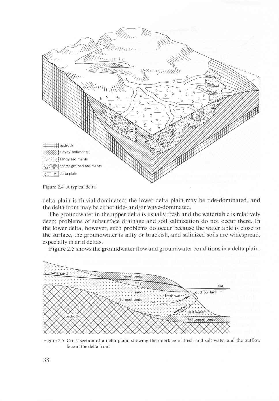
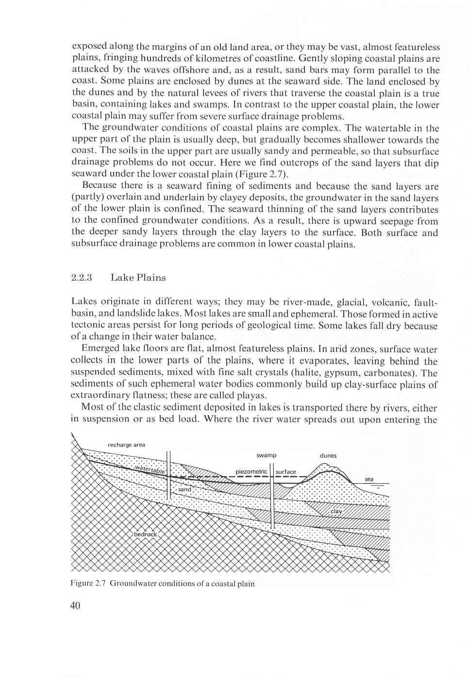
1 2 Groundwater Investigations N.A. de Ridder'? 2.1 Introduction Successful drainage depends largely on a proper diagnosis of the causes of the excess water. For this diagnosis, one must consider: climate, topography, pedology, surface water hydrology, irrigation, and groundwater hydrology (or hydrogeology). Each of these factors -either separately, or more often in combination - may create a surface drainage problem (flooding, ponding) or a subsurface drainage problem (shallow watertable, waterlogging), or a combination of these problems. Most of these factors are treated separately elsewhere in this book. In this chapter, we shall concentrate on some hydrogeological aspects of drainage problems, particularly those of subsurface drainage. Although each area has its own specific groundwater conditions, a close relationship exists between an area's groundwater conditions and its geological history. So, first, we shall discuss this relationship. For more information reference is made to Davis and De Wiest 1966 and Freeze and Cherry We shall then explain how to conduct a groundwater investigation, describing how to collect, process, and evaluate the groundwater data that are pertinent to subsurface drainage, for more details see UN For further reading Mandel and Shiftan 1981, Matthess 1982, Nielsen 1991, Price 1985 and Todd 1980 are recommended. 2.2 Land Forms Land forms are the most common features encountered by anyone engaged in drainage investigations. If land forms are properly interpreted, they can shed light upon an area's geological history and its groundwater conditions. The two major land forms on earth are mountains and plains. Plains are areas of low relief and have our main interest because they usually have rich agricultural resources that can be developed, provided their water management problems are solved. This does not mean that the drainage engineer can neglect the mountains bordering many such plains. Mountain ranges are the source of the sediments occurring in the plains. They are also the source of the rivers that carry the detritus to the plains where it is deposited when the rivers flood. Not all plains are of the same type; their source area, transporting agent, and depositional environment will differ. We recognize the following types of plains: - Alluvial plains, formed by rivers; - Coastal plains, formed by the emergence of the sea floor; - Lake plains, formed by the emergence of a lake floor; - Glacial plains, formed by glacial ice. ' International Institute for Land Reclamation and Improvement 33
2 The above list is not complete but covers the types of plains that are important for agriculture; they are also areas where drainage problems are common. Their main geological features and groundwater conditions will now be briefly described. For more information on land forms reference is made to Thornbury Alluvial Plains Alluvial plains are formed by rivers and usually have a horizontal structure. The larger alluvial plains, however, are downwarped and often faulted. They may contain alluvial sediments that are hundreds or even thousands of metres thick. Along the course of the river, from the mountains to the sea, we recognize three types of alluvial plains: - Alluvial fan; - River plain; - Delta plain. Alluvial Fans An alluvial fan is a cone-like body of alluvial materials laid down by a river debouching from a mountain range into lowland (Figure 2.1). Alluvial fans are found in both the humid and the arid zones. They occur in all sizes, the size being largely determined by the size and geology of the river catchment and the flow regime of the river. Boulders, gravel, and very coarse sand dominate the sediments at the fan head. The sediments usually become finer towards the distal end of the fan, where they may be silt or fine sandy loam. Because of the variability of a river s flow regime, alluvial fans are subject to rapid changes, with channels shifting laterally over a wide area, and channels alternating, cutting, and filling themselves. The mud-flow deposits extend as a continuous sheet over large areas, whereas the sand and gravel deposits are usually restricted to former channels. Because of the very coarse materials at the head of the fan and the many diverging stream channels, substantial quantities of river water percolate to the underground. The head of the fan is therefore a recharge zone. The middle part of the fan is mainly a transmission zone. The distal end of the fan is a zone of groundwater discharge. Owing to the presence of mud-flow deposits of low permeability, the groundwater in the deep sand and gravel deposits is confined (i.e. the water level in a well that penetrates the sand and gravel layers stands above these layers). The watertable, which is deep in the head of the fan, gradually becomes shallower towards the distal end, where it may be at, or close to, the surface. In arid zones, substantial quantities of groundwater are lost here by capillary rise and evaporation, which may turn the distal fan into a true salt desert. Whereas subsurface drainage problems are restricted to the distal fan, surface drainage problems may occasionally affect major parts of an alluvial fan, especially when heavy rains evacuate highly sediment-charged masses of water from the mountains. River Plains River plains are usually highly productive agricultural areas. Rivers occur in different 34
3
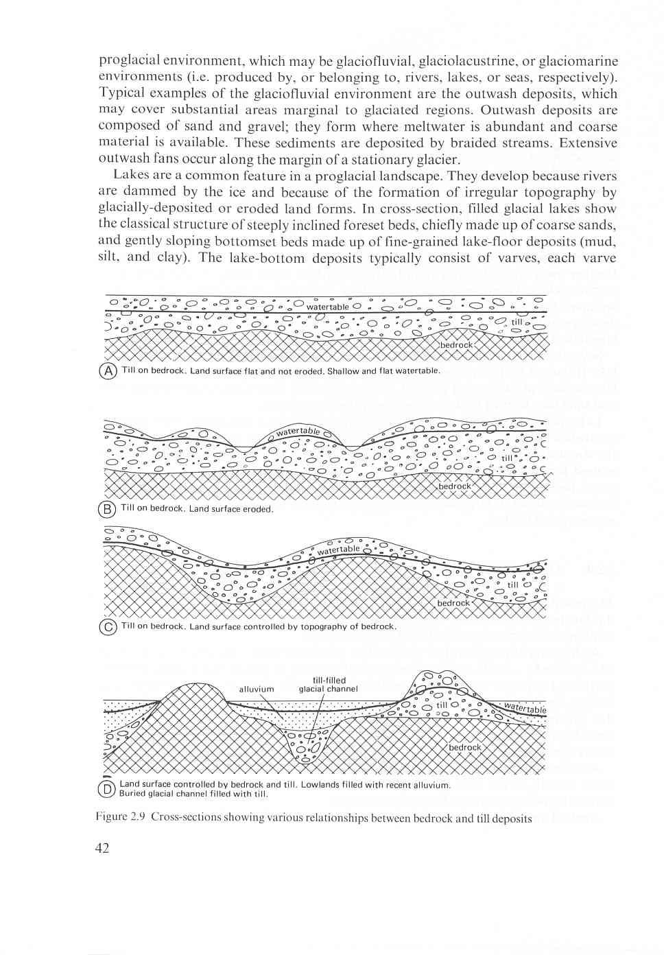
4 sizes and stages of development (Strahler 1965), but a common type is the graded river, which has reached a state of balance between the average supply of rock waste to the river and the average rate at which the river can transport the load. At this stage, the river meanders, cutting only sideways into its banks, thus forming a flat valley floor. In the humid zones, most of the large rivers have formed wide flood plains. Typical morphological features of a flood plain are the following (Figure 2.2): Immediately adjacent to the river are the natural levees or the highest ground on the flood plain; On the slip-off slope of a meander bend are point bars of sandy materials; Oxbow lakes or cut-off meander bends contain water; Some distance away from the river are backswamps or basin-like depressions; Terraces along the valley walls represent former flood plains of the river. Flood plain deposits vary from coarse sand and gravel immediately adjacent to the river, to peat and very heavy clays in the backswamps or basins (Figure 2.3A). In the quiet-water environments of these basins, layers of peat, peaty clay, and clay are deposited; they may be some 5 to 10 m thick. In many flood plains in the humid climates, a coarsening of sediments downward can be observed; continuous layers of coarse sand and gravel underlie most of those plains. These coarse materials were deposited under climatological conditions that differ from those of the present. At that time, the river was supplied with more rock waste than it could carry. Instead of flowing in a single channel, the river divided into numerous threads that coalesced and redivided. Such a river is known as a braided river. The channels shift laterally over a wide area; existing channels are filled with predominantly coarse sand and gravel, and new ones are cut. In cross-section, the sediments of braided rivers show a characteristic cut-and-fill structure (Figure 2.3B). A flood plain, as the name implies, is regularly flooded at high river stages, unless it is protected by artificial levees (dikes). Deforestation in the catchment area of the river aggravates the floodings. Subsurface drainage problems are common in such plains, especially in those of the humid climates. Shallow watertables and marshy conditions prevail in the poorly drained backswamps and other depressions. Seepage Figure 2.2 A broad river valley plain of the humid zone, with its typical morphological features 36
5
6
7
8
9
10
11 consisting of a lower coarse layer of very fine sand-to-silt and an upper layer of clay. Both climatic instability and powerful winds contribute to aeolian activity around a glacier or ice sheet. Sand reworked from glacial deposits is shaped into aeolian dunes. Silt is also readily picked up from glacial outwash and is deposited down-wind as loess, which is generally well-sorted and poorly stratified or non-stratified. Loess deposits can form blankets up to tens of metres thick and can extend hundreds of kilometres from the ice margin. Young glacial plains are often characterized by poor drainage. This is mainly due to the low permeability of the till deposits and the undeveloped drainage systems. Once a drainage system has developed, the drainage of the higher grounds will be better. Excess water from rainfall and from surface runoff may collect in local depressions and lowlands, causing flooding and high watertables. 2.3 Definitions Basic Concepts The water in the zone of saturation, called groundwater, occurs under different conditions. Where groundwater only partly fills an aquifer (a permeable layer), the upper surface of the saturated zone, known as the watertable, is free to rise and fall. The groundwater in such a layer is said to be unconfined, or to be under phreatic or watertable conditions (Figure 2.10A). Where groundwater completely fills a permeable layer that is overlain and underlain by aquicludes (i.e. impermeable layers), the upper surface of the saturated zone is fixed. Groundwater in such a layer is said to be confined, or to be under confined or artesian conditions (Figure 2.10B). The water level in a well or borehole that penetrates into the permeable layer stands above the top of that layer, or, if the artesian pressure is high, even above the land surface. Relative to a chosen reference level, piezometric level -----c- -- H o Figure 2.10 Different groundwater conditions: A: Unconfined (watertable, phreatic) conditions; B: Confined (artesian) conditions; C: Semiconfined conditions 43
12 the height of the water column in the well is called hydraulic head, being the sum of pressure head and elevation head. (This will be discussed further in Chapter 7.) Truly impermeable layers are not common in nature; most fine-textured layers possess a certain, though low, permeability. Where groundwater completely fills a permeable layer that is overlain by an aquitard (a poorly permeable layer) and underlain by an aquiclude or aquitard, the groundwater in the permeable layer is said to be semi-confined (Figure 2. loc). In the overlying aquitard, the groundwater is under unconfined conditions because it is free to rise and fall. The water level in a well or borehole that penetrates the permeable layer stands above the top of that layer or even above the land surface if the pressure is high. This type of groundwater condition is very common in nature. Three different situations can be recognized: - The water level in the well stands at the same height as the watertable in the overlying aquitard, which means that there is no exchange of water between the two layers; - The water level stands above the watertable in the aquitard, which means that there is an exchange of water between the two layers, with the permeable layer losing water to the aquitard; here, one speaks of upward seepage through the aquitard; - The watertable stands below the watertable in the aquitard; here, the permeable layer receives water from the aquitard, and one speaks of downward seepage (or natural drainage) through the aquitard. These three groundwater conditions can also occur in combination (e.g. in stratified soils, where permeable and less permeable layers alternate, or, besides seepage through the poorly permeable top layer, there may also be seepage through an underlying layer). In some areas, drainage problems can be caused by a perched watertable. The watertable may be relatively deep, but a hardpan or other impeding layer in the soil profile creates a local watertable above that layer or hardpan. It will be clear by now that an area s groundwater conditions are closely related to its geological history. As the geology of an area is usually variable, so too are its groundwater conditions. In a practical sense, the problem is one of identifying and evaluating the significance of boundaries that separate layers of different permeability. In subsurface drainage studies, we are interested primarily in the spatial distribution and continuity of permeability. In solutions to groundwater problems, permeable, poorly permeable, or impermeable layers are usually assumed to be infinite in extent. Obviously, no such layers exist in nature; all water-transmitting and confining layers terminate somewhere and have boundaries. Hydraulically, we recognize four types of boundaries: - Impermeable boundaries; - Head-controlled boundaries; - Flow-controlled boundaries; - Free-surface boundaries. An impermeable boundary is one through which no flow occurs or, in a practical sense, a boundary through which the flow is so small that it can be neglected. A 44
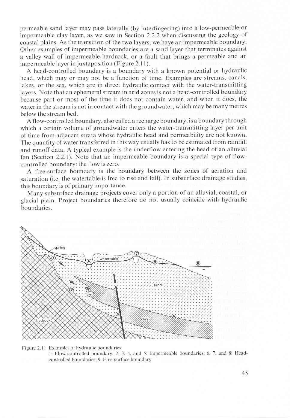
13
14 2.3.2 Physical Properties To describe the flow of water through the different layers, one needs data on the following physical properties: hydraulic conductivity, saturated thickness, transmissivity, drainable pore space, storativity, specific storage, hydraulic resistance, and the leakage factor. These will be briefly explained. Hydraulic Conductivity The hydraulic conductivity, K, is the constant of proportionality in Darcy s law and is defined as the volume of water that will move through a porous medium in unit time under a unit hydraulic gradient through a unit area measured at right angles to the direction of flow. Hydraulic conductivity can have any units of length/time (e.g. m/d). Its order of magnitude depends on the texture of the soil (Chapter 3) and is affected by the density and viscosity of the groundwater (Chapter 7). Saturated Thickness For confined aquifers, the saturated thickness, H, is equal to the physical thickness. of the aquifer between the aquicludes above and below it (Figure 2.10B). The same is true for a semi-confined aquifer bounded by an aquiclude and an aquitard (Figure 2.10C). In both these cases, the saturated thickness is a constant. Its order ofmagnitude can range from several metres to hundreds or even thousands of metres. For unconfined aquifers (Figure 2. loa), the saturated thickness, D, is equal to the difference in level between the watertable and the aquiclude. Because the watertable is free to rise and fall, the saturated thickness of an unconfined aquifer is not constant, but variable. It may range from a few metres to some tens of metres. Transmissivity The transmissivity, KH, is the product of the average hydraulic conductivity, K, and the saturated thickness of the aquifer, H. Consequently, the transmissivity is the rate of flow under a hydraulic gradient equal to unity through a cross-section of unit width and over the whole saturated thickness of the water-bearing layer. It has the dimensions of length2/time and can, for example, be expressed in m2/d. Its order of magnitude can be derived from those of K and H. Drainable Pore Space The drainable pore space, p, is the volume of water that an unconfined aquifer releases from storage per unit surface area of aquifer per unit decline of the watertable. Small pores do not contribute to the drainable pore space because the retention forces in them are greater than the weight of water. Hence, no groundwater will be released from small pores by gravity drainage. Drainable pore space is sometimes called specific yield, drainable porosity, or effective porosity. It is a dimensionless quantity, normally expressed as a percentage. Its value ranges from less than 5 per cent for clayey materials to 35 per cent for coarse sands and gravelly sands (Chapter 3). Storativity The storativity, S, of a saturated confined aquifer is the volume of water released 46
RIVERS, GROUNDWATER, AND GLACIERS
 RIVERS, GROUNDWATER, AND GLACIERS Delta A fan-shaped deposit that forms when a river flows into a quiet or large body of water, such as a lake, an ocean, or an inland sea. Alluvial Fan A sloping triangle
WATER ON AND UNDER GROUND. Objectives. The Hydrologic Cycle
 WATER ON AND UNDER GROUND Objectives Define and describe the hydrologic cycle. Identify the basic characteristics of streams. Define drainage basin. Describe how floods occur and what factors may make
Erosion Surface Water. moving, transporting, and depositing sediment.
 + Erosion Surface Water moving, transporting, and depositing sediment. + Surface Water 2 Water from rainfall can hit Earth s surface and do a number of things: Slowly soak into the ground: Infiltration
Streams. Water. Hydrologic Cycle. Geol 104: Streams
 Streams Why study streams? Running water is the most important geologic agent in erosion, transportation and deposition of sediments. Water The unique physical and chemical properties of water make it
11/22/2010. Groundwater in Unconsolidated Deposits. Alluvial (fluvial) deposits. - consist of gravel, sand, silt and clay
 deposits. - consist of gravel, sand, silt and clay") Groundwater in Unconsolidated Deposits Alluvial (fluvial) deposits - consist of gravel, sand, silt and clay - laid down by physical processes in rivers and flood plains - major sources for water supplies
Groundwater in Unconsolidated Deposits Alluvial (fluvial) deposits - consist of gravel, sand, silt and clay - laid down by physical processes in rivers and flood plains - major sources for water supplies
Surface Processes Focus on Mass Wasting (Chapter 10)
") Surface Processes Focus on Mass Wasting (Chapter 10) 1. What is the distinction between weathering, mass wasting, and erosion? 2. What is the controlling force in mass wasting? What force provides resistance?
Surface Processes Focus on Mass Wasting (Chapter 10) 1. What is the distinction between weathering, mass wasting, and erosion? 2. What is the controlling force in mass wasting? What force provides resistance?
Prof. Stephen A. Nelson EENS 111. Groundwater
 Page 1 of 8 Prof. Stephen A. Nelson EENS 111 Tulane University Physical Geology This page last updated on 20-Oct-2003 is water that exists in the pore spaces and fractures in rock and sediment beneath
Soils, Hydrogeology, and Aquifer Properties. Philip B. Bedient 2006 Rice University
 Soils, Hydrogeology, and Aquifer Properties Philip B. Bedient 2006 Rice University Charbeneau, 2000. Basin Hydrologic Cycle Global Water Supply Distribution 3% of earth s water is fresh - 97% oceans 1%
Prentice Hall EARTH SCIENCE
 Prentice Hall EARTH SCIENCE Tarbuck Lutgens Chapter 7 Glaciers, Desert, and Wind 7.1 Glaciers Types of Glaciers A glacier is a thick ice mass that forms above the snowline over hundreds or thousands of
Groundwater Hydrology
 EXERCISE 12 Groundwater Hydrology INTRODUCTION Groundwater is an important component of the hydrologic cycle. It feeds lakes, rivers, wetlands, and reservoirs; it supplies water for domestic, municipal,
Surface Water and Stream Development
 Surface Water and Stream Development Surface Water The moment a raindrop falls to earth it begins its return to the sea. Once water reaches Earth s surface it may evaporate back into the atmosphere, soak
Earth Science Chapter 9. Day 6 - Finish Capillary Action Lab - Quiz over Notes - Review Worksheets over Sections 9.2 and 9.3
 Earth Science Chapter 9 Day 1 Day 2 Day 3 Read Section 9.1 Surface Water Chapter 9 Term Sheet Notes over Section 9.1 Surface Water Section 9.1 Review Worksheets Quiz over Section 9.1 Notes Virtual Lab
EROSION AND DEPOSITION
 CHAPTER 8 EROSION AND DEPOSITION SECTION 8 1 Changing Earth s Surface (pages 252-255) This section explains how sediment is carried away and deposited elsewhere to wear down and build up Earth s surface.
,Baynes Lake. TO...?&.?...A 2...KO.?'!!&... Sr. *logical Engineer
 > i evernment OF BRITISH COLUMBIA a TO...?&.?...A 2....KO.?'!!&... Sr. *logical Engineer... Grou,,water. Section Hydrology Division Wat.er... In~.~s.tiga.ti.On.s..Branck.... 5 u BJECT...C;.roun.dw.ater...Snve
STUDY GUIDE FOR CONTENT MASTERY. Surface Water Movement
 Surface Water SECTION 9.1 Surface Water Movement In your textbook, read about surface water and the way in which it moves sediment. Complete each statement. 1. An excessive amount of water flowing downslope
Bell Ringer. Are soil and dirt the same material? In your explanation be sure to talk about plants.
 Bell Ringer Are soil and dirt the same material? In your explanation be sure to talk about plants. 5.3 Mass Movements Triggers of Mass Movements The transfer of rock and soil downslope due to gravity is
 12 10 8 6 4 2 0 40-50 50-60 60-70 70-80 80-90 90-100 Fresh Water What we will cover The Hydrologic Cycle River systems Floods Groundwater Caves and Karst Topography Hot springs Distribution of water in
What we will cover. The Hydrologic Cycle. River systems. Floods. Groundwater. Caves and Karst Topography. Hot springs
 Fresh Water What we will cover The Hydrologic Cycle River systems Floods Groundwater Caves and Karst Topography Hot springs On a piece of paper, put these reservoirs of water in to order from largest to
ES 105 Surface Processes I. Hydrologic cycle A. Distribution % in oceans 2. >3% surface water a. +99% surface water in glaciers b.
 ES 105 Surface Processes I. Hydrologic cycle A. Distribution 1. +97% in oceans 2. >3% surface water a. +99% surface water in glaciers b. >1/3% liquid, fresh water in streams and lakes~1/10,000 of water
GEOL 1121 Earth Processes and Environments
 GEOL 1121 Earth Processes and Environments Wondwosen Seyoum Department of Geology University of Georgia e-mail: seyoum@uga.edu G/G Bldg., Rm. No. 122 Seyoum, 2015 Chapter 6 Streams and Flooding Seyoum,
6.1 Water. The Water Cycle
 6.1 Water The Water Cycle Water constantly moves among the oceans, the atmosphere, the solid Earth, and the biosphere. This unending circulation of Earth s water supply is the water cycle. The Water Cycle
11/12/2014. Running Water. Introduction. Water on Earth. The Hydrologic Cycle. Fluid Flow
 Introduction Mercury, Venus, Earth and Mars share a similar history, but Earth is the only terrestrial planet with abundant water! Mercury is too small and hot Venus has a runaway green house effect so
Essentials of Geology, 11e
 Essentials of Geology, 11e Groundwater Chapter 10 Instructor Jennifer Barson Spokane Falls Community College Geology 101 Stanley Hatfield Southwestern Illinois Co Jennifer Cole Northeastern University
Section I: Multiple Choice Select the best answer to each question. Mark your final answer on the answer sheet. (1 pt each)
") Sedimentary Rocks & Surface Processes Quest Name: Earth Science 2013 Block: Date: Section I: Multiple Choice Select the best answer to each question. Mark your final answer on the answer sheet. (1 pt each)
Sedimentary Rocks & Surface Processes Quest Name: Earth Science 2013 Block: Date: Section I: Multiple Choice Select the best answer to each question. Mark your final answer on the answer sheet. (1 pt each)
Summary. Streams and Drainage Systems
 Streams and Drainage Systems Summary Streams are part of the hydrologic cycle and the chief means by which water returns from the land to the sea. They help shape the Earth s surface and transport sediment
Chapter 3 Erosion and Deposition. The Big Question:
 Chapter 3 Erosion and Deposition The Big Question: 1 Design a way to represent and describe the 4 types of mass movement. You may use pictures, diagrams, list, web, chart, etc 2 Chapter 3: Erosion and
Erosion and Deposition
 Erosion and Deposition Erosion Sediment natural forces move rock/soil from one place to another. gravity, water, wind, glaciers, waves are causes material moved by erosion Deposition when erosion lays
Sediment and sedimentary rocks Sediment
 Sediment and sedimentary rocks Sediment From sediments to sedimentary rocks (transportation, deposition, preservation and lithification) Types of sedimentary rocks (clastic, chemical and organic) Sedimentary
EARTH S CHANGING SURFACE
 EARTH S CHANGING SURFACE Weathering Together, weathering and erosion work continuously to wear down the material on Earth s surface. weathering process that breaks down rock and other substances of Earth
Pre-Lab Reading Questions ES202
 ES202 The are designed to encourage students to read lab material prior to attending class during any given week. Reading the weekly lab prior to attending class will result in better grade performance
Weathering, Erosion, Deposition, and Landscape Development
 Weathering, Erosion, Deposition, and Landscape Development I. Weathering - the breakdown of rocks into smaller particles, also called sediments, by natural processes. Weathering is further divided into
Lecture Outlines PowerPoint. Chapter 5 Earth Science 11e Tarbuck/Lutgens
 Lecture Outlines PowerPoint Chapter 5 Earth Science 11e Tarbuck/Lutgens 2006 Pearson Prentice Hall This work is protected by United States copyright laws and is provided solely for the use of instructors
Prentice Hall EARTH SCIENCE
 Prentice Hall EARTH SCIENCE Tarbuck Lutgens Running Water and Groundwater Running Water The Water Cycle Water constantly moves among the oceans, the atmosphere, the solid Earth, and the biosphere. This
27. Running Water I (p ; )
") 27. Running Water I (p. 424-436; 440-444) Hydrosphere How much of the Earth s surface is covered by water? Earth's water is collectively called the and is stored in a number of so-called as follows: 1.
27. Running Water I (p. 424-436; 440-444) Hydrosphere How much of the Earth s surface is covered by water? Earth's water is collectively called the and is stored in a number of so-called as follows: 1.
Final Exam. Running Water Erosion and Deposition. Willamette Discharge. Running Water
 Final Exam Running Water Erosion and Deposition Earth Science Chapter 5 Pages 120-135 Scheduled for 8 AM, March 21, 2006 Bring A scantron form A calculator Your 3 x 5 paper card of formulas Review questions
Chapter 13. Groundwater
 Chapter 13 Groundwater Introduction Groundwater is all subsurface water that completely fills the pores and other open spaces in rocks, sediments, and soil. Groundwater is responsible for forming beautiful
Land subsidence due to groundwater withdrawal in Hanoi, Vietnam
 Land Subsidence (Proceedings of the Fifth International Symposium on Land Subsidence, The Hague, October 1995). 1AHS Publ. no. 234, 1995. 55 Land subsidence due to groundwater withdrawal in Hanoi, Vietnam
Geology and New England Landscapes
 Geology and New England Landscapes Jim Turenne, CPSS USDA-NRCS Warwick, RI. http://nesoil.com Why Geology? Provides the big picture of site conditions. Major part of soil formation (parent material and
Fresh Water: Streams, Lakes Groundwater & Wetlands
 Fresh Water:, Lakes Groundwater & Wetlands Oct 27 Glaciers and Ice Ages Chp 13 Nov 3 Deserts and Wind and EXAM #3 Slope hydrologic cycle P = precip I = precip intercepted by veg ET = evapotranspiration
Laboratory Exercise #4 Geologic Surface Processes in Dry Lands
 Page - 1 Laboratory Exercise #4 Geologic Surface Processes in Dry Lands Section A Overview of Lands with Dry Climates The definition of a dry climate is tied to an understanding of the hydrologic cycle
Surface Processes. Water Cycle. Evaporation Transpiration Condenstation Precipitation Infiltration Runoff
 s e s s roce S P e c urfa s e s s e c o r P e s c d r a a f C r Su iew Note v e R Water Cycle Evaporation Transpiration Condenstation Precipitation Infiltration Runoff Runoff The moving of water along
Chapter 5: Glaciers and Deserts
 I. Glaciers and Glaciation Chapter 5: Glaciers and Deserts A. A thick mass of ice that forms over land from the compaction and recrystallization of snow and shows evidence of past or present flow B. Types
Chapter 8: Learning objectives
 Chapter 8: Learning objectives Understand concept of sedimentary facies Signinifance of lateral and vertical facies associations Walther s Law Understand the sedimentary facies of alluvial fans, eolian
UGRC 144 Science and Technology in Our Lives/Geohazards
 UGRC 144 Science and Technology in Our Lives/Geohazards Flood and Flood Hazards Dr. Patrick Asamoah Sakyi Department of Earth Science, UG, Legon College of Education School of Continuing and Distance Education
Running Water Earth - Chapter 16 Stan Hatfield Southwestern Illinois College
 Running Water Earth - Chapter 16 Stan Hatfield Southwestern Illinois College Hydrologic Cycle The hydrologic cycle is a summary of the circulation of Earth s water supply. Processes involved in the hydrologic
Jim Turenne. Soils on Social Media
 Jim Turenne USDA-NRCS 60 Quaker Lane, Suite 46 Warwick, RI. 02886 401-822-8832 Jim.turenne@ri.usda.gov Soils on Social Media www.twitter.com/soilsne www.fb.com/soilsne www.nesoil.com U.S. Department of
Earth Science Chapter 6 Section 2 Review
 Name: Class: Date: Earth Science Chapter 6 Section Review Multiple Choice Identify the choice that best completes the statement or answers the question. 1. Most streams carry the largest part of their
Topic 6: Weathering, Erosion and Erosional-Deposition Systems (workbook p ) Workbook Chapter 4, 5 WEATHERING
 Workbook Chapter 4, 5 WEATHERING") Topic 6: Weathering, Erosion and Erosional-Deposition Systems (workbook p. 95-125) Workbook Chapter 4, 5 THE BIG PICTURE: Weathering, erosion and deposition are processes that cause changes to rock material
Topic 6: Weathering, Erosion and Erosional-Deposition Systems (workbook p. 95-125) Workbook Chapter 4, 5 THE BIG PICTURE: Weathering, erosion and deposition are processes that cause changes to rock material
Evolution of the conceptual hydrogeologic and ground-water flow model for Las Vegas Valley, Clark County, Nevada
 Evolution of the conceptual hydrogeologic and ground-water flow model for Las Vegas Valley, Clark County, Nevada Geological Society of America Annual Meeting November 14, 2 David J. Donovan Southern Nevada
Streams. Stream Water Flow
 CHAPTER 14 OUTLINE Streams: Transport to the Oceans Does not contain complete lecture notes. To be used to help organize lecture notes and home/test studies. Streams Streams are the major geological agents
1.72, Groundwater Hydrology Prof. Charles Harvey Lecture Packet #5: Groundwater Flow Patterns. Local Flow System. Intermediate Flow System
 1.72, Groundwater Hydrology Prof. Charles Harvey Lecture Packet #5: Groundwater Flow Patterns c Local Flow System 10,000 feet Intermediate Flow System Regional Flow System 20,000 feet Hydrologic section
Which map shows the stream drainage pattern that most likely formed on the surface of this volcano? A) B)
 B)") 1. When snow cover on the land melts, the water will most likely become surface runoff if the land surface is A) frozen B) porous C) grass covered D) unconsolidated gravel Base your answers to questions
1. When snow cover on the land melts, the water will most likely become surface runoff if the land surface is A) frozen B) porous C) grass covered D) unconsolidated gravel Base your answers to questions
Laboratory Exercise #3 The Hydrologic Cycle and Running Water Processes
 Laboratory Exercise #3 The Hydrologic Cycle and Running Water Processes page - 1 Section A - The Hydrologic Cycle Figure 1 illustrates the hydrologic cycle which quantifies how water is cycled throughout
Appendix I SOIL RATING CHART. (Storie soil Index Rating = factor A* factor B* factor C* factor X) FACTOR A- Rating on character of Physical Profile
 FACTOR A- Rating on character of Physical Profile") Appendix I SOIL RATING CHART (Storie soil Index Rating = factor A* factor B* factor C* factor X) FACTOR A- Rating on character of Physical Profile Sr. No Particulars Percentage I Soil on recent alluvial
Appendix I SOIL RATING CHART (Storie soil Index Rating = factor A* factor B* factor C* factor X) FACTOR A- Rating on character of Physical Profile Sr. No Particulars Percentage I Soil on recent alluvial
GEOL.3250 Geology for Engineers Glacial Geology
 GEOL.3250 Geology for Engineers Glacial Geology NAME Part I: Continental Glaciation Continental glaciers are large ice sheets that cover substantial portions of the land area. In the region of accumulation
Essential Questions. What is erosion? What is mass wasting?
 Erosion Essential Questions What is erosion? What is mass wasting? What is Erosion? Erosion The transportation of sediment from one area to another Caused mainly by running water but also caused by glaciers,
What are the different ways rocks can be weathered?
 Romano - 223 What are the different ways rocks can be weathered? Weathering - the breakdown of rocks and minerals at the Earth s surface 1. 2. PHYSICAL WEATHERING Rock is broken into smaller pieces with
Impact of the Danube River on the groundwater dynamics in the Kozloduy Lowland
 GEOLOGICA BALCANICA, 46 (2), Sofia, Nov. 2017, pp. 33 39. Impact of the Danube River on the groundwater dynamics in the Kozloduy Lowland Peter Gerginov Geological Institute, Bulgarian Academy of Sciences,
mountain rivers fixed channel boundaries (bedrock banks and bed) high transport capacity low storage input output
 high transport capacity low storage input output") mountain rivers fixed channel boundaries (bedrock banks and bed) high transport capacity low storage input output strong interaction between streams & hillslopes Sediment Budgets for Mountain Rivers Little
mountain rivers fixed channel boundaries (bedrock banks and bed) high transport capacity low storage input output strong interaction between streams & hillslopes Sediment Budgets for Mountain Rivers Little
UNIT 4: Earth Science Chapter 21: Earth s Changing Surface (pages )
") CORNELL NOTES Directions: You must create a minimum of 5 questions in this column per page (average). Use these to study your notes and prepare for tests and quizzes. Notes will be turned in to your teacher
CORNELL NOTES Directions: You must create a minimum of 5 questions in this column per page (average). Use these to study your notes and prepare for tests and quizzes. Notes will be turned in to your teacher
Mark S. Nordberg Geology and Groundwater Investigations Section North Central Region Office California Department of Water Resources
 Mark S. Nordberg Geology and Groundwater Investigations Section North Central Region Office California Department of Water Resources Ukiah Drought Workshop July 29, 2009 Groundwater 101 Groundwater is
Conceptual Model of Stream Flow Processes for the Russian River Watershed. Chris Farrar
 Conceptual Model of Stream Flow Processes for the Russian River Watershed Chris Farrar Several features of creeks affect the interactions between surface and groundwater. This conceptual model uses the
Landscape Development
 Landscape Development Slopes Dominate Natural Landscapes Created by the interplay of tectonic and igneous activity and gradation Deformation and uplift Volcanic activity Agents of gradation Mass wasting
FLUVIAL LANDFORMS. Floodplains
 FLUVIAL LANDFORMS Floodplains fairly flat & continuous surface occupying much of a valley bottom normally underlain by unconsolidated sediments subject to periodic flooding (usually once every year or
EXTERNAL LAND FORMING PROCESSES
 NAME SCHOOL INDEX NUMBER DATE EXTERNAL LAND FORMING PROCESSES WEATHERING 1 1998 Q 7 (a) (i) What is the difference between weathering and mass wasting (ii) List five processes involved in chemical weathering
Chapter 14: Groundwater. Fig 14.5b
 Chapter 14: Groundwater Fig 14.5b OBJECTIVES Recognize that groundwater is a vital source of accessible freshwater. Describe how groundwater forms below the water table. Explain the origin of aquifers,
Maggie Payne Jim Turenne
 Maggie Payne Jim Turenne USDA-NRCS 60 Quaker Lane, Suite 46 Warwick, RI. 02886 401-822-8832 maggie.payne@ri.usda.gov U.S. Department of Agriculture 1935: Soil Conservation Service (SCS) Natural Resources
Lab 7: Sedimentary Structures
 Name: Lab 7: Sedimentary Structures Sedimentary rocks account for a negligibly small fraction of Earth s mass, yet they are commonly encountered because the processes that form them are ubiquitous in the
STUDY GUIDE FOR CONTENT MASTERY. Movement and Storage of Groundwater
 Groundwater SECTION 10.1 Movement and Storage of Groundwater In your textbook, read about the hydrosphere, precipitation and groundwater, and groundwater storage. Use the following terms to complete the
Lecture Outlines PowerPoint. Chapter 6 Earth Science 11e Tarbuck/Lutgens
 Lecture Outlines PowerPoint Chapter 6 Earth Science 11e Tarbuck/Lutgens 2006 Pearson Prentice Hall This work is protected by United States copyright laws and is provided solely for the use of instructors
every continent has an extensive dry region! " deserts are as much as 1/3 of Earth s surface!
 deserts! deserts! every continent has an extensive dry region! " deserts are as much as 1/3 of Earth s surface! Hollywood portrayal of vast stretches of sand dune! " Sahara has only 10% covered by sand!
4. The map below shows a meandering stream. Points A, B, C, and D represent locations along the stream bottom.
 1. Sediment is deposited as a river enters a lake because the A) velocity of the river decreases B) force of gravity decreases C) volume of water increases D) slope of the river increases 2. Which diagram
Chapter 2. Wearing Down Landforms: Rivers and Ice. Physical Weathering
 Chapter 2 Wearing Down Landforms: Rivers and Ice Physical Weathering Weathering vs. Erosion Weathering is the breakdown of rock and minerals. Erosion is a two fold process that starts with 1) breakdown
Groundwater. (x 1000 km 3 /y) Oceans Cover >70% of Surface. Groundwater and the. Hydrologic Cycle
 Oceans Cover >70% of Surface. Groundwater and the. Hydrologic Cycle") Chapter 17 Oceans Cover >70% of Surface Groundwater and the Hydrologic Cycle Vasey s Paradise, GCNP Oceans are only 0.025% of Mass Groundwater Groundwater is liquid water that lies in the subsurface in
Chapter 17 Oceans Cover >70% of Surface Groundwater and the Hydrologic Cycle Vasey s Paradise, GCNP Oceans are only 0.025% of Mass Groundwater Groundwater is liquid water that lies in the subsurface in
1/6/ th Grade Earth s Surface. Chapter 3: Erosion and Deposition. Lesson 1 (Mass Movement)
") Lesson 1 (Mass Movement) 7 th Grade Earth s Surface Chapter 3: Erosion and Deposition Weathering the chemical and physical processes that break down rock at Earth s surface Mechanical weathering when rock
Lesson 1 (Mass Movement) 7 th Grade Earth s Surface Chapter 3: Erosion and Deposition Weathering the chemical and physical processes that break down rock at Earth s surface Mechanical weathering when rock
Mass Movements, Wind, and Glaciers
 Mass Movements,, and Glaciers SECTION 8.1 Mass Movement at Earth s Surface In your textbook, read about mass movement. Use each of the terms below just once to complete the passage. avalanche creep landslide
MASS MOVEMENTS, WIND, AND GLACIERS
 Date Period Name MASS MOVEMENTS, WIND, AND GLACIERS SECTION.1 Mass Movements In your textbook, read about mass movements. Use each of the terms below just once to complete the passage. avalanche creep
Depositional Environment
 Depositional Environment Sedimentary depositional environment describes the combination of physical, chemical and biological processes associated with the deposition of a particular type of sediment. Types
1. Any process that causes rock to crack or break into pieces is called physical weathering. Initial product = final product
 Weathering 1. Any process that causes rock to crack or break into pieces is called physical weathering. Initial product = final product End Result of physical weathering is increased surface area. 2. Physical
Enhanced Characterization of the Mississippi River Valley Alluvial Aquifer Using Surface Geophysical Methods
 Photo by Shane Stocks, U.S. Geological Survey Enhanced Characterization of the Mississippi River Valley Alluvial Aquifer Using Surface Geophysical Methods Presented by Ryan F. Adams US Geological Survey
Class Notes: Surface Processes
 Name: Date: Period: Surface Processes The Physical Setting: Earth Science Class Notes: Surface Processes I. Weathering and Soils Weathering -! Sediments -! Weathering occurs when rocks are exposed to:
Year 6. Geography. Revision
 Year 6 Geography Revision November 2017 Rivers and World knowledge How the water cycle works and the meaning of the terms evaporation, condensation, precipitation, transpiration, surface run-off, groundwater
Page 1. Name:
 Name: 1) Which event is the best example of erosion? dissolving of rock particles on a limestone gravestone by acid rain breaking apart of shale as a result of water freezing in a crack rolling of a pebble
Soil Formation. Lesson Plan: NRES B2-4
 Soil Formation Lesson Plan: NRES B2-4 1 Anticipated Problems 1. What are five different factors that affect soil formation? 2. What are some different types of parent material that affect soils? 3. What
1 Water Beneath the Surface
 CHAPTER 16 1 Water Beneath the Surface SECTION Groundwater KEY IDEAS As you read this section, keep these questions in mind: What are two properties of aquifers? How is the water table related to the land
Name. 4. The diagram below shows a soil profile formed in an area of granite bedrock. Four different soil horizons, A, B, C, and D, are shown.
 Name 1. In the cross section of the hill shown below, which rock units are probably most resistant to weathering? 4. The diagram below shows a soil profile formed in an area of granite bedrock. Four different
Chapter 7 Permeability and Seepage
 Permeability and Seepage - N. Sivakugan (2005) 1 7.1 INTRODUCTION Chapter 7 Permeability and Seepage Permeability, as the name implies (ability to permeate), is a measure of how easily a fluid can flow
The future of the Lowland Belizean Savannas?.
 The future of the Lowland Belizean Savannas?. Using cluster analysis to explore multivariate spatial patterns in savanna soils PETER FURLEY & SARAH BEADLE UK Belize association 15 th November 2014 Outline
Sediment and Sedimentary rock
 Sediment and Sedimentary rock Sediment: An accumulation of loose mineral grains, such as boulders, pebbles, sand, silt or mud, which are not cemented together. Mechanical and chemical weathering produces
The Hydrologic Cycle
 CONTINENTAL DEPOSITIONAL ENVIRONMENTS fluvial desert lacustrine (lake) Glacial KEY PARAMETERS (VARIABLES) 1. Climate (Hydrologic Cycle) Annual Precip vs. Seasonality 2. Tectonics (Mountains) The Hydrologic
Chapter 14. Groundwater
 Chapter 14 Groundwater Importance of groundwater! Groundwater is water found in the pores of soil and sediment, plus narrow fractures in bedrock! Groundwater is the largest reservoir of fresh water that
STREAM SYSTEMS and FLOODS
 STREAM SYSTEMS and FLOODS The Hydrologic Cycle Precipitation Evaporation Infiltration Runoff Transpiration Earth s Water and the Hydrologic Cycle The Hydrologic Cycle The Hydrologic Cycle Oceans not filling
Precipitation Evaporation Infiltration Earth s Water and the Hydrologic Cycle. Runoff Transpiration
 STREAM SYSTEMS and FLOODS The Hydrologic Cycle Precipitation Evaporation Infiltration Earth s Water and the Hydrologic Cycle Runoff Transpiration The Hydrologic Cycle The Hydrologic Cycle Oceans not filling
Ms. A. Mormando's Class *
 8 th Grade Science Essential Standard: 8.E.1.1 Explain the structure of the hydrosphere including: Water distribution on Earth; Local river basin and water availability Stream - A stream is a body of water
Erosion and Deposition
 CHAPTER 3 LESSON 2 Erosion and Deposition Landforms Shaped by Water and Wind Key Concepts What are the stages of stream development? How do water erosion and deposition change Earth s surface? How do wind
Rivers T. Perron
 1 Rivers T. Perron 12.001 After our discussions of large-scale topography, how we represent topography in maps, and how topography interacts with geologic structures, you should be frothing at the mouth
Science EOG Review: Landforms
 Mathematician Science EOG Review: Landforms Vocabulary Definition Term canyon deep, large, V- shaped valley formed by a river over millions of years of erosion; sometimes called gorges (example: Linville
Lowland Glaciation North Wales
 Lowland Glaciation North Wales Background Although there have been many glaciations and advances in ice, the most significant for this are was the Dimlington Stadial which was a period of glacial advance
MASS WASTING/MASS MOVEMENTS; GROUNDWATER; RIVERS; Glaciation and Deserts
 DATE DUE: Ms. Terry J. Boroughs Geology 305 Name: LANDSCAPES MASS WASTING/MASS MOVEMENTS; GROUNDWATER; RIVERS; Glaciation and Deserts Instructions: Read each question carefully before selecting the BEST
GEOL Introductory Geology: Exploring Planet Earth Fall 2010 Test #2 October 18, 2010
 GEOL 101 - Introductory Geology: Exploring Planet Earth Fall 2010 Test #2 October 18, 2010 Name KEY ID# KEY Multiple choice questions (2 points each). 1. What type of metamorphic rock is formed over large