URANIUM GEOLOGY NIGER, WEST AFRICA
|
|
|
- Abigayle McCarthy
- 5 years ago
- Views:
Transcription
1 URANIUM GEOLOGY NIGER, WEST AFRICA Exploration History The starting point of uranium history in Niger can be set at 1957 with the discovery of uranium showings at Azelik by the Bureau Minier de la France d'outre-mer. The French Commissariat à l'energie Atomique, informed about this discovery when uranium was actively being sought, almost immediately started a detailed study of the showings and launched an airborne survey. Then, a succession of discoveries followed: Azelik and Abokorum in 1959; Madaouela in 1963; Arlette, Ariège, Artois, Taza, Tamou and Takriza in 1965; Imouraren in 1966; and Akouta in At the same time, Niger, as a country, experienced several major milestones in its history with the creation of the Republic of Niger in 1958, followed by its independence from France in August To some extent, one can say that the history of modern Niger coincides with the history of its uranium industry. The Société des Mines de l'aïr (Somaïr) was the first uranium company to be incorporated in February 1968 after the discovery and development in 1965 of the Ariège, Artois and Arlette deposits. Its mill started in 1970 and two production lines, with a total capacity of 2,300 tu per year, have been added since La Compagnie Minière d Akouta (Cominak) was set up as a company in 1974, after the discovery in 1967 of the Akouta and Akola deposits. Cominak is an underground mine and its entrance at Akouta provides access to the producing stopes at a depth of about 250 meters. The current production capacity of the mill is about 2,500 tu per year. Regional Geology Aïr Massif The Aïr Massif, the Hoggar and the Adrar des Iforas form the Touareg Shield, which along with the Benin-Nigerian Shield, is part of the Central African mobile belt, deformed by the Panafrican orogeny about 600 million years ago. The crystalline basement of the Aïr is composed of a central, highly metamorphosed core intruded by panafrican granitoïds. The crystalline core is separated from only slightly metamorphosed terrain by the important overthrust sheets of Tafadek to the west and Aouzegeur to the east. The molasse formations of the "Proche-Tenere" are supposedly Infracambrian in age. They are sub-horizontal, only slightly metamorphosed and lie discordant on the Suggarian basement. Subvolcanic ring complexes of Paleozoic age, intruding through the Suggarian basement, constitute the northern extremity of the younger granites that extends into neighboring Nigeria.
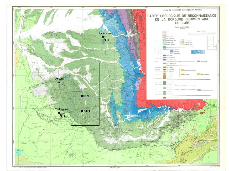
2 The Aïr Massif structure is an anticlinorium with kilometric isoclinal folds dipping to the east. The north-south thrusts, inwardly dipping, characterize a panafrican collision between the West African Craton and the Central African Mobile Zone after an oceanic enclosure. Iullemmeden Basin The Iullemmeden Basin, to the west of the Aïr Massif, is a vast structural depression of about 360,000 km² covering virtually all of western Niger and with extensions in Algeria, Mali, Benin and Nigeria. It is filled with 1,500 to 2,000 meters of Cambrian to Pleistocene sediments of alternating marine and continental origin. The Paleozoic formations outcrop in the Tim Mersoï Basin near Tamesna-Talak area, along the western margin of the Aïr Massif. Upper Carboniferous units, especially the Guezouman, the Tarat and the Madaouela sandstones host uranium occurrences. Carboniferous units also host coal deposits in the Anou Araren area. A thick sequence of Permian to Lower Cretaceous age sandstones and shales form what is known as the Middle Continental series, or Continental intercalaire, which outcrops main1y in the Tamesna, Irhazer and Tegama areas. These formations host uranium- and copper-rich horizons as well as saline-rich horizons mineable for salt. The Upper Cretaceous and the Lower Tertiary are marine in origin and composed of a succession of argillites, marls, and fossiliferous limestones with silty, sandy and gritty horizons. These formations outcrop essentially in the Ader Douchi and the Daergou. Local Geology The Irhazer and In Gall concessions are located in a desert plain about 80 kilometers to the west of the Aïr Massif. The Irhazer shales cover almost entirely the perimeter of the concessions; few mounds of sandstone appear near some faults. Formations from the Tegama are present in the southwest corner of the Irhazer concession. The major tectonic features are the Arlit fault to the east, the Teguida N Adrar fault crossing the northern part of the In Gall concession and two zones of fractures across the concessions that are oriented N30 to N45. The zones of fractures could be particularly favorable to the concentration of uranium mineralization. The geological targets are lenses of sandstone and conglomerate within the lower part of the Irhazer formation. Most of the economic uranium mineralization in the Tim Mersoï Basin is within sandstone and conglomerate formations inserted between layers of siltstone and shale, rich in organic plants, or over a surface of discontinuity resulting from major erosion. The crystalline basement of the Aïr Massif, and more particularly plutonic granite, is likely the source of the mineralization, which is structurally controlled by the Arlit fault and its satellite fracture zones.
3 The host rocks are more recent to the south and to the west; indeed the uranium showings north of latitude N19 are from Devonian-Carboniferous formations, whereas the Arlit and Akouta deposits further south are within Permian-Carboniferous units. The Abokorum-Azelik deposits further west are in lenses of sandstone at the base of the Irhazer formation from the Lower Cretaceous. Economic Geology Sources of Uranium Mineralization Niger's main uranium resources are all contained in the sediments of the Tim Mersoï sub-basin, which is mainly the continental part of the sedimentary layers of the Iullemmeden Basin. The large deposits currently mined by Cominak and Somaïr are located respectively in the Guezouman conglomeratic formation, supposedly of a Visean age, and in the Tarat sandstone formation, which is younger and supposedly of a Namurian age. Upward in the sedimentary pile, other mineralizations and deposits have been identified, the most important one being the Imouraren deposit located in the Tchirezrine sandstone of a Jurassic age. To describe the deposits in a very simple way, one can characterize them as belonging to the sandstone type uranium deposits. In situ leaching mining methods are considered for the low-grade mineralization of the Imouraren orebody. The currently mined deposits are recovered through conventional mining methods. Uranium Mining In 2005, Niger uranium production reached 3,093tU, making Niger one of the world s largest uranium producers. Niger is one of the most important uranium-bearing provinces of the world. Its contribution to past uranium production has already been mentioned as one of the few showing a cumulative production in the range of 100,000 tu. Its remaining uranium resources recoverable at less than US$15 per pound of U3O8 (uranium oxide) are estimated at more than 200,000 tu. Total reserves (tu recoverable as concentrates) are: Mine/Project Total reserves (tu) Average grade (Kg U/t) Cominak 29,050 5 Somaïr 14,160 3 Imouraren 80, Shares in the Cominak mine are held by Cogema-France (65%), OURD-Japan (25%) and ENUSA-Spain (10%). Shares in the Somaïr mine are held by Cogema (64%) and Onarem (36%).

4
5
URANIUM, FROM EXPLORATION TO MINING- NIGER REPUBLIC
 URANIUM, FROM EXPLORATION TO MINING- NIGER REPUBLIC TECHNICAL MEETING ON URANIUM FROM UNCONVENTIONAL RESOURCES IAEA HEADQUATER, VIENNA, AUSTRIA 4 7 NOVEMBER 2014 By NA-ALLAH MAMANE (MINING ENGINEER, Ag.
Official languages: French and Arabic.
 Location: Chad is a landlocked Country located in the center of Africa, between 7 o and 23 o North Latitude, 13 o and 24 o East Longitude. Neighbour Country: Libya to the North; Central African Republic
Structural Geology of the Mountains
 Structural Geology of the Mountains Clinton R. Tippett Shell Canada Limited, Calgary, Alberta clinton.tippett@shell.ca INTRODUCTION The Southern Rocky Mountains of Canada (Figure 1) are made up of several
GEOLOGY GL1 Foundation Unit
 Candidate Name Centre Number Candidate Number 2 General Certificate of Education Advanced Subsidiary/Advanced 451/01 GEOLOGY GL1 Foundation Unit P.M. THURSDAY, 10 January 2008 (1 hour) Examiner Question
BALOCHISTAN FOLDBELT BASIN
 INTRODUCTION BALOCHISTAN FOLDBELT BASIN The Kharan-3 block is located in the Kharan Trough of Balochistan Basin. GEOLOGICAL SETTING The Balochistan Province is an Upper Cretaceous to Recent structurally
Regional GIS based exploration targeting studies in data poor environments
 Regional GIS based exploration targeting studies in data poor environments A case study of gold prospectivity mapping in Nigeria Matthew Greentree, Mathieu Lacorde and Bert De Waele Acknowledgements Australian
EXISTING GEOLOGICAL INFORMATION
 CHAPER 3 EXISTING GEOLOGICAL INFORMATION 3-1 General Geology of the Surrounding Area (1) General geology and ore deposits in Mongolia Geographically, Mongolia is a country located between Russia to the
The Building of the NYC Region
 The Building of the NYC Region Definitions Fall Line marks the area where an upland region (continental bedrock) and a coastal plain meet Piedmont the plateau region of the eastern United States which
MUHAMMAD S TAMANNAI, DOUGLAS WINSTONE, IAN DEIGHTON & PETER CONN, TGS Nopec Geological Products and Services, London, United Kingdom
 Geological and Geophysical Evaluation of Offshore Morondava Frontier Basin based on Satellite Gravity, Well and regional 2D Seismic Data Interpretation MUHAMMAD S TAMANNAI, DOUGLAS WINSTONE, IAN DEIGHTON
REPUBLIC OF CHAD. Ministry of Oil,Mines and Energy
 REPUBLIC OF CHAD Ministry of Oil,Mines and Energy presented by: Mr. DJEDOUBOUM Emmanuel Ambroise and Mr. BRAHIM ABDERAMANE YACINE E-mail: djed_emma@yahoo.fr/brahimyacine93@yahoo.fr 10-14 November,2014/Johannesburg
Mesozoic Earth History
 Mesozoic Earth History The Mesozoic Era 251-66 MYA Breakup of Pangea Changes in air and oceanic currents Evolution of new terrestrial and marine life Opening of the Atlantic Ocean Basin Rocky Mountains
Tu D Understanding the Interplay of Fractures, Stresses & Facies in Unconventional Reservoirs - Case Study from Chad Granites
 Tu D201 04 Understanding the Interplay of Fractures, Stresses & Facies in Unconventional Reservoirs - Case Study from Chad Granites D. Lirong (Chinese National Petroleum Company Ltd. (Chad)), C. Shrivastava*
ENVI.2030L Geologic Time
 Name ENVI.2030L Geologic Time I. Introduction There are two types of geologic time, relative and absolute. In the case of relative time geologic events are arranged in their order of occurrence. No attempt
Geologic History of Texas: The Making of Texas Over 1.5 Billion Years
 # 4 Geologic History of Texas: The Making of Texas Over 1.5 Billion Years Dr. Richard Kyle March 24, 2000 Produced by and for Hot Science - Cool Talks by the Environmental Science Institute. We request
entered a rapid development phase. Annual increased proven reserves are above 500 billion cubic meters (bcm) from 2003, and annual natural gas product
 from 2003, and annual natural gas product") (), entered a rapid development phase. Annual increased proven reserves are above 500 billion cubic meters (bcm) from 2003, and annual natural gas production has increased from 50bcm in 2000 to nearly
(), entered a rapid development phase. Annual increased proven reserves are above 500 billion cubic meters (bcm) from 2003, and annual natural gas production has increased from 50bcm in 2000 to nearly
Copyright McGraw-Hill Education. All rights reserved. No reproduction or distribution without the prior written consent of McGraw-Hill Education
 Copyright McGraw-Hill Education. All rights reserved. No reproduction or distribution without the prior written consent of McGraw-Hill Education Tibetan Plateau and Himalaya -southern Asia 11.00.a VE 10X
Prepare by: Pars Geological Research Center (Arian Zamin) August 2012
 August 2012") Prepare by: Pars Geological Research Center (Arian Zamin) August 2012 Position, boundaries and area of Iran Iran is located in southwest of the Continent of Asia like a bridge connecting three continents
Prepare by: Pars Geological Research Center (Arian Zamin) August 2012 Position, boundaries and area of Iran Iran is located in southwest of the Continent of Asia like a bridge connecting three continents
NI TECHNICAL REPORT
 NI 43-101 TECHNICAL REPORT DASA Uranium Project Mineral Resource Update, Central Niger For Global Atomic Corporation CSA Global Report: Nº R317.2018 30 June 2018 www.csaglobal.com Report prepared for Client
Meandering Miocene Deep Sea Channel Systems Offshore Congo, West Africa
 Meandering Miocene Deep Sea Channel Systems Offshore Congo, West Africa S. Baer* (PGS), J. E. Comstock (PGS), K. Vrålstad (PGS), R. Borsato (PGS), M. Martin (PGS), J.P. Saba (SNPC), B. Débi-Obambé (SNPC)
Unconformities are depositional contacts that overlie rocks distinctly older than they are. They are often called gaps in the sedimentary record.
 UNCONFORMITIES Unconformities are depositional contacts that overlie rocks distinctly older than they are. They are often called gaps in the sedimentary record. The contact represents time when no sediment
Strike-Slip Faults. ! Fault motion is parallel to the strike of the fault.
 Strike-Slip Faults! Fault motion is parallel to the strike of the fault.! Usually vertical, no hanging-wall/footwall blocks.! Classified by the relative sense of motion. " Right lateral opposite block
Chapter 3. Geology & Tectonics
 Chapter 3 Geology & Tectonics 3.1 Geology The general geological features of Indonesia are shown in Figure 3.1. The basement formation is metamorphic and it is intruded with plutonic formations. They are
Earth History Exam. The remains of an early dinosaur could be found at reference point A. A B. B C. C D. D. page 1
 Name: Date: 1. Base your answer(s) to the following question(s) on the Earth Science Reference Tables and your knowledge of Earth science. The accompanying cross section shows undisturbed sedimentary bedrock.
1. The timeline below represents time on Earth from the beginning of the Paleozoic Era Ato the present B.
 Name Roy G Biv 1. The timeline below represents time on Earth from the beginning of the Paleozoic Era Ato the present B. Which numbered position best represents the time when humans first appeared in the
GY 112L Earth History
 GY 112L Earth History Lab 2 Vertical Successions and Sequences of Events GY 112L Instructors: Douglas Haywick, James Connors, Mary Anne Connors Department of Earth Sciences, University of South Alabama
TECHNICAL REPORT: REGIONAL GEOLOGY AND TECTONICS Resume. Huachon Project, Cerro de Pasco departments, Peru. By: AFC Logistic SAC
 TECHNICAL REPORT: REGIONAL GEOLOGY AND TECTONICS Resume Huachon Project, Cerro de Pasco departments, Peru By: AFC Logistic SAC December 2016 1. INTRODUCTION GPM Metals Peru, in its portfolio of generating
History of Earth. Chapter 9: HISTORY OF EARTH. The Solar System. Early Earth: A Giant Impact! Early Earth. Formation of the Solar System
 Chapter 9: HISTORY OF EARTH The Essential Earth, 2 nd Edition Thomas H. Jordan & John Grotzinger History of Earth Earth is 4.56 Billion Years Old Earth has experienced a rich and diverse history that we
Fossils, Geologic Time, Absolute & Relative Dating, and Natural Resources. Chapters 5 & 6
 Fossils, Geologic Time, Absolute & Relative Dating, and Natural Resources Chapters 5 & 6 How Do Fossils Form? Fossils are found in sedimentary rocks like sandstone, limestone, and shale In Virginia, most
COMPAGNIE MINIÈRE CONGOLAISE S.P.R.L. - CoMiCo
 COMPAGNIE MINIÈRE CONGOLAISE S.P.R.L. - CoMiCo assets in the Cuvette Centrale (Busira and Lokoro Sub-Basins) of the Democratic Republic of Congo March 2008 Prepared by HRT - HIGH RESOLUTION TECHNOLOGY
Why is it called the "Inland Basins" Region?
 Learning Series: Rocks of the Southeastern U. S. The BIG Picture Why is it called the "Inland Basins" Region? Inland from the mountains, the Earth s crust was buckled (downwarped) into a series of depressions
Nortec Minerals announces Option to acquire 100% interest in the Cottonwood Vanadium-Uranium Project, Utah
 Nortec Minerals announces Option to acquire 100% interest in the Cottonwood Vanadium-Uranium Project, Utah Vancouver, BC / The Newswire / March 8, 2019 (the Company or Nortec ) (TSXV: NVT): Nortec announces
Virginia T. McLemore, New Mexico Bureau of Geology and Mineral Resources, New Mexico Institute of Mining and Technology, Socorro, NM 87801,
 Virginia T. McLemore, New Mexico Bureau of Geology and Mineral Resources, New Mexico Institute of Mining and Technology, Socorro, NM 87801, ginger@gis.nmt.edu U2011, Casper, Wy September 20, 2011 Acknowledgments
Plan of Development Mountain Valley Pipeline Project. APPENDIX P Plan for Unanticipated Discovery of Paleontological Resources
 APPENDIX P Plan for Unanticipated Discovery of Paleontological Resources Appendix P Plan for Unanticipated Discovery of Paleontological Resources Prepared by: TABLE OF CONTENTS 1.0 INTRODUCTION... 1 1.1
Anthill Resources Yukon - An Update on the Einarson Project
 Anthill Resources Yukon - An Update on the Einarson Project The Eastern Extension of a Carlin-type Gold Trend in the Selwyn Basin Anthill Resources Ltd Yukon Claim Holdings Over 2400 km 2 Property Location
Outline 16: The Mesozoic World: Formation of Oil Deposits (with a side trip to the Devonian Marcellus Shale)
") Outline 16: The Mesozoic World: Formation of Oil Deposits (with a side trip to the Devonian Marcellus Shale) The first commercial oil well was drilled by Colonel Edwin Drake in Titusville, Pennsylvania,
Outline 16: The Mesozoic World: Formation of Oil Deposits (with a side trip to the Devonian Marcellus Shale) The first commercial oil well was drilled by Colonel Edwin Drake in Titusville, Pennsylvania,
Results of Preliminary Study of Shale Gas and Shale Oil Perspectives in Georgia
 World Experience in Shale Oil & Gas Industry and prospects of its Development in Georgia Results of Preliminary Study of Shale Gas and Shale Oil Perspectives in Georgia By: Archil Magalashvili Murman Margvelashvili
Geology 12 FINAL EXAM PREP. Possible Written Response Exam Questions
 Geology 12 FINAL EXAM PREP Possible Written Response Exam Questions Use this study guide to prepare for the written response portion of the final exam. Name FINAL EXAM - POSSIBLE WRITTEN RESPONSE QUESTIONS
Answers: Internal Processes and Structures (Isostasy)
") Answers: Internal Processes and Structures (Isostasy) 1. Analyse the adjustment of the crust to changes in loads associated with volcanism, mountain building, erosion, and glaciation by using the concept
Answers: Internal Processes and Structures (Isostasy) 1. Analyse the adjustment of the crust to changes in loads associated with volcanism, mountain building, erosion, and glaciation by using the concept
As compaction and cementation of these sediments eventually occur, which area will become siltstone? A) A B) B C) C D) D
 A B) B C) C D) D") 1. A student obtains a cup of quartz sand from a beach. A saltwater solution is poured into the sand and allowed to evaporate. The mineral residue from the saltwater solution cements the sand grains together,
1. A student obtains a cup of quartz sand from a beach. A saltwater solution is poured into the sand and allowed to evaporate. The mineral residue from the saltwater solution cements the sand grains together,
GEOLOGY - GL4 INTERPRETING THE GEOLOGICAL RECORD
 Candidate Name Centre Number 2 Candidate Number GCE A level 1214/01 GEOLOGY - GL4 INTERPRETING THE GEOLOGICAL RECORD A.M. MONDAY, 21 June 2010 2 hours Section A 1. 2. 3. 15 15 15 1214 01 01 4. 15 Section
Presented at The AusIMM Bulletin International Uranium Conference 2013, Darwin, June 2013
 The Miriam case: A new type of uranium deposit within the Carboniferous sandstonehosted Uranium Mineralisation of the Arlit Agadez province, Tim Mersoi Basin, Niger Henri Sanguinetti, Exploration Manager,
GEOLOGIC MAPS PART II
 EARTH AND ENVIRONMENT THROUGH TIME LABORATORY - EES 1005 LABORATORY FIVE GEOLOGIC MAPS PART II Introduction Geologic maps of orogenic belts are much more complex than maps of the stable interior. Just
Section 7. Reading the Geologic History of Your Community. What Do You See? Think About It. Investigate. Learning Outcomes
 Chapter 3 Minerals, Rocks, and Structures Section 7 Reading the Geologic History of Your Community What Do You See? Learning Outcomes In this section, you will Goals Text Learning Outcomes In this section,
Structural Styles and Geotectonic Elements in Northwestern Mississippi: Interpreted from Gravity, Magnetic, and Proprietary 2D Seismic Data
 Structural Styles and Geotectonic Elements in Northwestern Mississippi: Interpreted from Gravity, Magnetic, and Proprietary 2D Seismic Data Nick Loundagin 1 and Gary L. Kinsland 2 1 6573 W. Euclid Pl.,
Unit 5: Earth s History Practice Problems
 Name: Date: 1. Which bedrock would be most likely to contain fossils? A. Precambrian granite B. Cambrian shale C. Pleistocene basalt D. Middle-Proterozoic quartzite 6. Base your answer(s) to the following
Section 5. Rock Units and Your Community. What Do You See? Think About It. Investigate. Learning Outcomes
 Chapter 3 Minerals, Rocks, and Structures Section 5 Rock Units and Your Community What Do You See? Learning Outcomes In this section, you will Recognize that rocks are arranged in Earth s crust as well-defined
Uranium Resources in Canada. Presentation to the Bureau d audiences publiques sur l environnement Quebec City, September 8, 2014
 1 Uranium Resources in Canada Presentation to the Bureau d audiences publiques sur l environnement Quebec City, September 8, 2014 2 Recoverable Resources based on Confidence of Estimates: A Few Terms (IAEA/NEA
Structural Geology Lab. The Objectives are to gain experience
 Geology 2 Structural Geology Lab The Objectives are to gain experience 1. Drawing cross sections from information given on geologic maps. 2. Recognizing folds and naming their parts on stereoscopic air
Petroleum Systems (Part One) Source, Generation, and Migration
 Source, Generation, and Migration") Petroleum Systems (Part One) Source, Generation, and Migration GEOL 4233 Class January 2008 Petroleum Systems Elements Source Rock Migration Route Reservoir Rock Seal Rock Trap Processes Generation Migration
Petroleum Systems (Part One) Source, Generation, and Migration GEOL 4233 Class January 2008 Petroleum Systems Elements Source Rock Migration Route Reservoir Rock Seal Rock Trap Processes Generation Migration
Vail et al., 1977b. AAPG 1977 reprinted with permission of the AAPG whose permission is required for further use.
 Well 5 Well 4 Well 3 Well 2 Well 1 Vail et al., 1977b AAPG 1977 reprinted with permission of the AAPG whose permission is required for further use. Well 5 Well 4 Well 3 Well 2 Well 1 Vail et al., 1977b
ASX Company Announcement
 ASX Company Announcement Yellow Rock Resources ACN: 116 221 740 35 Great Eastern Highway Rivervale WA 6103 Telephone: (08) 9361 5400 Facsimile: (08) 9361 5900 Email: info@aurium.com.au Companies Announcement
GLY 155 Introduction to Physical Geology, W. Altermann. Press & Siever, compressive forces. Compressive forces cause folding and faulting.
 Press & Siever, 1995 compressive forces Compressive forces cause folding and faulting. faults 1 Uplift is followed by erosion, which creates new horizontal surface. lava flows Volcanic eruptions cover
3/5/05 Dr. Stewart 1
 I. Physiography of Appalachian Mountains A. Introduction 1. These mountains extend from NE Canada to Georgia 2. They are the remains of a deeply eroded, ancient mountain chain once larger than the Himalayans
Name. GEOL.5220 Structural Geology Faults, Folds, Outcrop Patterns and Geologic Maps. I. Properties of Earth Materials
 I. Properties of Earth Materials GEOL.5220 Structural Geology Faults, Folds, Outcrop Patterns and Geologic Maps Name When rocks are subjected to differential stress the resulting build-up in strain can
Potential for Shale Gas in Georgia:
 Potential for Shale Gas in Georgia: Preliminary Study for Feasibility Analysis of Shale Gas Exploration in Georgia Prepared for: AEAI under Grant Agreement #ECI GA R2 48 Georgia Energy Capacity Initiative
Continental Landscapes
 Continental Landscapes Landscape influenced by tectonics, climate & differential weathering Most landforms developed within the last 2 million years System moves toward an equilibrium Continental Landscapes
Ministry of Oil and Minerals Petroleum Exploration & Production Authority BLOCK 85 (Al Uqlah North)
") Ministry of Oil and Minerals Petroleum Exploration & Production Authority BLOCK 85 (Al Uqlah North) The Al Uqlah North Block (85) occupies an area of 597 km 2 in the Sabatayn Basin in the province of Shabwah
Ministry of Oil and Minerals Petroleum Exploration & Production Authority BLOCK 85 (Al Uqlah North) The Al Uqlah North Block (85) occupies an area of 597 km 2 in the Sabatayn Basin in the province of Shabwah
Overview of Selected Shale Plays in New Mexico*
 Overview of Selected Shale Plays in New Mexico* Ron Broadhead 1 Search and Discovery Article #10627 (2014)** Posted August 18, 2014 *Adapted from presentation at RMAG luncheon meeting, Denver, Colorado,
COAL MINING IN ZIMBABWE
 COAL MINING IN ZIMBABWE by MabasaTemba HAWADI, Director, ZIMBABWE GEOLOGICAL SURVEY Ministry of Mines and Mining Development 30 March, 2012 CONTENTS 1. INTRODUCTION 2. OUTLINE OF GEOLOGY 3. COAL RESOURCES
TIBESTI COPPER DEVELOPMENT PROJECT REPUBLIC OF CHAD
 TIBESTI COPPER DEVELOPMENT PROJECT REPUBLIC OF CHAD TIBESTI COPPER PROJECT SCOPING STUDY HIGHLIGHTS A long-term significant cash-flow Pre-feasibility study to begin to evaluate the project optimisations,
Petroleum geology framework, West Coast offshore region
 Petroleum geology framework, West Coast offshore region James W. Haggart* Geological Survey of Canada, Vancouver, BC jhaggart@nrcan.gc.ca James R. Dietrich Geological Survey of Canada, Calgary, AB and
Geologic Trips San Francisco and the Bay Area
 Excerpt from Geologic Trips San Francisco and the Bay Area by Ted Konigsmark ISBN 0-9661316-4-9 GeoPress All rights reserved. No part of this book may be reproduced without written permission in writing,
EAS 233 Geologic Structures and Maps Winter Miscellaneous practice map exercises. 1. Fault and separation:
 Miscellaneous practice map exercises 1. Fault and separation: With respect to Map 1, what are (a) the orientation of the fault, and (b) the orientation of bedding in the units cut by the fault. (c) Mark
Sediment and sedimentary rocks Sediment
 Sediment and sedimentary rocks Sediment From sediments to sedimentary rocks (transportation, deposition, preservation and lithification) Types of sedimentary rocks (clastic, chemical and organic) Sedimentary
Ministry of Oil and Minerals Petroleum Exploration & Production Authority BLOCK 6 (Iryam)
") Ministry of Oil and Minerals Petroleum Exploration & Production Authority BLOCK 6 (Iryam) The Iryam Block (6) occupies an area of 3,911 km 2 in the Sabatayn Basin in the province of Shabwah in central
Ministry of Oil and Minerals Petroleum Exploration & Production Authority BLOCK 6 (Iryam) The Iryam Block (6) occupies an area of 3,911 km 2 in the Sabatayn Basin in the province of Shabwah in central
3. GEOLOGY. 3.1 Introduction. 3.2 Results and Discussion Regional Geology Surficial Geology Mine Study Area
 3. GEOLOGY 3.1 Introduction This chapter discusses the baseline study of the geology and mineralization characteristics of the mine study area. The study consolidates existing geological data and exploration
A TRIP THROUGH VIRGINIA GEOLOGY FROM AN ENGINEER S PERSPECTIVE
 A TRIP THROUGH VIRGINIA GEOLOGY FROM AN ENGINEER S PERSPECTIVE Bob Moss, PE Principal Engineer ECS Mid Atlantic, LLC The Engineer Parent WHY IS AN UNDERSTANDING OF LOCAL GEOLOGY IMPORTANT? It provides
December 21, Chapter 11 mountain building E.notebook. Feb 19 8:19 AM. Feb 19 9:28 AM
 Mountains form along convergent plate boundaries. Typically (usually) if you look at a mountain range, you know that it is at a plate boundary (active continental margin) or has been some time in the past
Sedimentary Rocks. Origin, Properties and Identification. Physical Geology GEOL 101 Lab Ray Rector - Instructor
 Sedimentary Rocks Origin, Properties and Identification Physical Geology GEOL 101 Lab Ray Rector - Instructor Sedimentary Rock Origin and Identification Lab Pre-Lab Internet Link Resources 1) http://www.rockhounds.com/rockshop/rockkey/index.html
Topics Laramide Orogeny: Late Cretaceous to Early Eocene Reading: GSA DNAG volume 3, Ch. 6
 Topics Laramide Orogeny: Late Cretaceous to Early Eocene Reading: GSA DNAG volume 3, Ch. 6 Late Cretaceous to early Eocene New patterns developed 5 main regions Tectonic interpretations Post-Laramide events
Earth Science, (Tarbuck/Lutgens) Chapter 10: Mountain Building
 Chapter 10: Mountain Building") Earth Science, (Tarbuck/Lutgens) Chapter 10: Mountain Building 1) A(n) fault has little or no vertical movements of the two blocks. A) stick slip B) oblique slip C) strike slip D) dip slip 2) In a(n) fault,
Earth Science, (Tarbuck/Lutgens) Chapter 10: Mountain Building 1) A(n) fault has little or no vertical movements of the two blocks. A) stick slip B) oblique slip C) strike slip D) dip slip 2) In a(n) fault,
L.K. Carr 1, R.J. Korsch 1, A.J. Mory 2, R.M. Hocking 2, S.K. Marshall 1, R.D. Costelloe 1, J. Holzschuh 1, J.L. Maher 1. Australia.
 STRUCTURAL AND STRATIGRAPHIC ARCHITECTURE OF WESTERN AUSTRALIA S FRONTIER ONSHORE SEDIMENTARY BASINS: THE WESTERN OFFICER AND SOUTHERN CARNARVON BASINS L.K. Carr 1, R.J. Korsch 1, A.J. Mory 2, R.M. Hocking
SEDIMENTARY BASINS BASIN TYPES ACCORDING TO TECTONIC. by Prof. Dr. Abbas Mansour
 SEDIMENTARY BASINS BASIN TYPES ACCORDING TO TECTONIC by Prof. Dr. Abbas Mansour B. Convergent plate margins 10. STABLE CONTINENTAL INTERIOR BASIN E.g. Lake Eyre Basin Intracratonic (= within stable continental
Geologic Structures. Changes in the shape and/or orientation of rocks in response to applied stress
 Geologic Structures Changes in the shape and/or orientation of rocks in response to applied stress Figure 15.19 Can be as big as a breadbox Or much bigger than a breadbox Three basic types Fractures >>>
Lab 7: Sedimentary Structures
 Name: Lab 7: Sedimentary Structures Sedimentary rocks account for a negligibly small fraction of Earth s mass, yet they are commonly encountered because the processes that form them are ubiquitous in the
Unit 5 Possible Test Questions Mesozoic and Cenozoic Eras HISTORICAL GEOLOGY
 Revised 8/16 Unit 5 Possible Test Questions Mesozoic and Cenozoic Eras HISTORICAL GEOLOGY Mesozoic Era Eons, Eras and Periods 1. List the Mesozoic periods in order (oldest to youngest). End of the Paleozoic
PLATE TECTONICS THEORY
 PLATE TECTONICS THEORY Continental drift Sea floor spreading CONTINENTAL DRIFT CONTINENTAL DRIFT 1. The fitness of continents and Continental Reconstruction Earth ~200 million years ago 1.1 Geometrical
GEOLOGY OF PRAGUE ITS INTERACTION WITH THE PRAGUE METRO
 Underground M3 meeting, November 3-5, 2008, Prague GEOLOGY OF PRAGUE ITS INTERACTION WITH THE PRAGUE METRO Svatoslav Chamra Department of Geotechnics Faculty of Civil Engineering Czech Technical University
Name: Date: Period: Page 1
 Name: Date: Period: Base your answers to questions 1 through 4 on the three bedrock outcrops below and on your knowledge of Earth science. The outcrops, labeled I, II, and III, are located within 15 kilometers
NAME HOMEWORK ASSIGNMENT #3 MATERIAL COVERS CHAPTERS 8, 9, 10, 11
 NAME HOMEWORK ASSIGNMENT #3 MATERIAL OVERS HAPTERS 8, 9, 10, 11 Assignment is due the beginning of the class period on November 23, 2004. Answers for each chapter will be discussed in class, as Exam #3
Geology (Mellow) Hike, Santa Lucia Memorial Park February 16, I. Overview of Santa Lucia Range geology and tectonic history
 Hike, Santa Lucia Memorial Park February 16, I. Overview of Santa Lucia Range geology and tectonic history") Geology (Mellow) Hike, Santa Lucia Memorial Park February 16, 2015 I. Overview of Santa Lucia Range geology and tectonic history A. Basement Rocks 1. Salinian Block Rocks Sierra Nevada Type, continental
Geology (Mellow) Hike, Santa Lucia Memorial Park February 16, 2015 I. Overview of Santa Lucia Range geology and tectonic history A. Basement Rocks 1. Salinian Block Rocks Sierra Nevada Type, continental
3. The diagram below shows how scientists think some of Earth's continents were joined together in the geologic past.
 1. The map below shows the present-day locations of South America and Africa. Remains of Mesosaurus, an extinct freshwater reptile, have been found in similarly aged bedrock formed from lake sediments
454/01 GEOLOGY GL4 EXTENSION GEOLOGY. P.M. FRIDAY, 14 June (2 Hours)
") WELSH JOINT EDUCATION COMMITTEE General Certificate of Education Advanced CYD-BWYLLGOR ADDYSG CYMRU Tystysgrif Addysg Gyffredinol Uwch 454/01 GEOLOGY GL4 EXTENSION GEOLOGY P.M. FRIDAY, 14 June 2002 (2
WELSH JOINT EDUCATION COMMITTEE General Certificate of Education Advanced CYD-BWYLLGOR ADDYSG CYMRU Tystysgrif Addysg Gyffredinol Uwch 454/01 GEOLOGY GL4 EXTENSION GEOLOGY P.M. FRIDAY, 14 June 2002 (2
Sedimentary Rocks. Origin, Properties and Identification. Geology Laboratory GEOL 101 Lab Ray Rector - Instructor
 Sedimentary Rocks Origin, Properties and Identification Geology Laboratory GEOL 101 Lab Ray Rector - Instructor Sedimentary Rock Origin and Identification Lab Pre-Lab Internet Link Resources 1) http://www.rockhounds.com/rockshop/rockkey/index.html
Amador Canyon Silver Mining Property Lander County, NV
 Amador Canyon Silver Mining Property Lander County, NV Over $1 million worth of exploration and evaluation work performed Favorable drill results including a return of 286 g/ton silver over 12.2 meters
PALEOGEOGRAPHY of NYS. Definitions GEOLOGIC PROCESSES. Faulting. Folding 9/6/2012. TOPOGRAPHIC RELIEF MAP of NYS GRADATIONAL TECTONIC
 TOPOGRAPHIC RELIEF MAP of NYS PALEOGEOGRAPHY of NYS Prof. Anthony Grande AFG 2012 Definitions GEOLOGIC PROCESSES Geography: study of people living on the surface of the earth. Geology: the scientific study
GY111 Earth Materials Practice Final Exam
 I. True/False Questions: circle a T for true or F for false (10% total -or- 0.5 per) 1. (T F) The Uranium used in nuclear power plants may explode if not controlled properly. 2. (T F) Natural Gas is an
GCE AS/A level 1211/01 GEOLOGY GL1 Foundation Unit
 Surname Centre Number Candidate Number Other Names 2 GCE AS/A level 1211/01 GEOLOGY GL1 Foundation Unit S15-1211-01 A.M. MONDAY, 11 May 2015 1 hour For s use Question Maximum Mark 1. 15 2. 14 Mark Awarded
L.O: HOW GEOLOGISTS SEQUENCE EVENTS IN EARTH'S GEOLOGIC HISTORY IF NOT OVERTURNED, OLDEST ON BOTTOM, YOUNGEST ON TOP
 L.O: HOW GEOLOGISTS SEQUENCE EVENTS IN EARTH'S GEOLOGIC HISTORY IF NOT OVERTURNED, OLDEST ON BOTTOM, YOUNGEST ON TOP 1. Unless a series of sedimentary rock layers has been overturned, the bottom rock layer
EVALUATION OF AQUIFER CHARACTERISTICS FOR SELECTED NEW METHOD OF THE UM RUWABA FORMATION: NORTH KORDOFAN STATE, SUDAN
 EVALUATION OF AQUIFER CHARACTERISTICS FOR SELECTED NEW METHOD OF THE UM RUWABA FORMATION: NORTH KORDOFAN STATE, SUDAN ELHAGA.B *1; ELZIENS.M*2 ANDLISSANN.H*3 *1Department of C i v i l E n g i n e e r i
Before Plate Tectonics: Theory of Continental Drift
 Before Plate Tectonics: Theory of Continental Drift Predecessor to modern plate tectonics Shape and fit of the continents was the initial evidence Snider-Pelligrini (1858) Taylor (1908) Wegner (1915) Fig.
The Geology of Pacific Northwest Rocks & Minerals Activity 1: Geologic Time
 Name: Age: I. Introduction There are two types of geologic time, relative and absolute. In the case of relative time geologic events are arranged in their order of occurrence. No attempt is made to determine
Page 1. Name:
 Name: Questions 1 through 3 refer to the following: The diagrams below represent two rock outcrops found several miles apart in New York State. Individual rock layers are lettered, and fossils and rock
Central West Greenland. 2. Lead
 Locality/Name: Region: Longitude: Latitude: Commodities: Economic significance: Maarmorillik, Black Angel Central West Greenland 51 15'9.2''W 71 9'14.6''N 1. Zinc 2. Lead Mine, closed Geological setting:
KEY CHAPTER 12 TAKE-HOME QUIZ INTERNAL STRUCTURES AND PROCESSES Score Part B = / 55 PART B
 GEOLOGY 12 KEY CHAPTER 12 TAKE-HOME QUIZ INTERNAL STRUCTURES AND PROCESSES Score Part B = / 55 PART B CHAPTER 12 Isostacy and Structural Geology 1. Using the terms below, label the following diagrams and
Metamorphic fluids, Naxos, Greece
 Field trip Naxos, Greece, course B, SS 2014: Prof. Dr. J. Urai Metamorphic fluids, Naxos, Greece Tilman Scheele Applied Geosciences EMR, RWTH Aachen Introduction Naxos is located in the central Aegean
C) Trenton limestone
 Trenton limestone") 1. Base your answer to the following question on the Earth Science Reference Tables, the core section below, and your knowledge of Earth Science. The core section shows the subsurface bedrock geology for
1. Base your answer to the following question on the Earth Science Reference Tables, the core section below, and your knowledge of Earth Science. The core section shows the subsurface bedrock geology for
North Greenland collection of oblique aerial photographs - (Twin Otter photos)
") North Greenland collection of oblique aerial photographs - (Twin Otter photos) The Geological Survey of Greenland (now part of the Geological Survey of Denmark and Greenland: GEUS) carried out a systematic
North Greenland collection of oblique aerial photographs - (Twin Otter photos) The Geological Survey of Greenland (now part of the Geological Survey of Denmark and Greenland: GEUS) carried out a systematic
1. Base your answer to the following question on The diagram below represents a part of the crystal structure of the mineral kaolinite.
 1. Base your answer to the following question on The diagram below represents a part of the crystal structure of the mineral kaolinite. An arrangement of atoms such as the one shown in the diagram determines
Phanerozoic (last 0.54 by) Tectonics Climate Life
 Tectonics Climate Life") Phanerozoic (last 0.54 by) Tectonics Climate Life Tools for Locating Past Continent Positions Fossils depending on climate Alignment of geological features Geometrical fit of continental margins Similarity
Phanerozoic (last 0.54 by) Tectonics Climate Life Tools for Locating Past Continent Positions Fossils depending on climate Alignment of geological features Geometrical fit of continental margins Similarity