AEOLIAN FEATURES STS ISS017 E ISS016 E 6986 STS STS ISS012 E ISS016 E ISS013 E 18533
|
|
|
- Patricia Parker
- 5 years ago
- Views:
Transcription


1 1 2 ISS017 E STS ISS016 E 6986 STS Expedition Earth and Beyond ARES Education Program Images courtesy of: Image Science & Analysis Laboratory AEOLIAN FEATURES 5 6 ISS012 E STS ISS016 E ISS013 E 18533
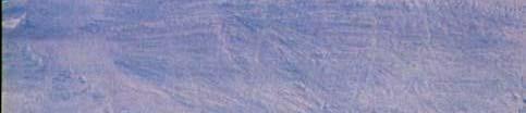
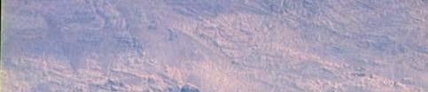
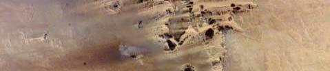
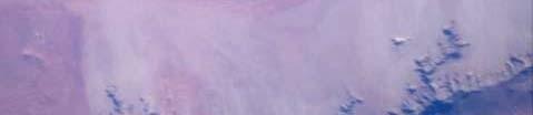
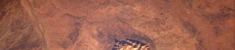
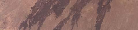
2 AEOLIAN FEATURE: SAND DUNES Geographic Location: ALGERIA Image ID#: STS AEOLIAN FEATURE: SAND DUNES Geographic Location: EGYPT Image ID#: ISS017 E This astronaut image is showing a large area of orange colored sand dunes in Algeria called the Tifernine Dunes. This area is part of the Sahara desert. Drainage channels show where water once flowed through the area when the climate was wetter. OTHER VISIBLE FEATURE(S): Drainage channels This astronaut image is taken of an area in northern Egypt almost completely covered in sand dunes. This area, west of Cairo, is part of the Sahara Desert. OTHER VISIBLE FEATURE(S): Clouds, cloud shadows AEOLIAN FEATURE: YARDANGS Geographic Location: NAMIBIA Image ID#: STS AEOLIAN FEATURE: SAND DUNES Geographic Location: UNITED STATES Image ID#: ISS016 E This astronaut image is taken of yardangs in an area along the northern coast of Namibia called the Skeleton Coast. This astronaut image is taken of the Sangre de Cristo Mountains and sand dunes located in Great Sand Dunes National Park in Colorado. OTHER VISIBLE FEATURE(S): Coastline The mountains areoutlined by dark green forests atlower elevations and white, snow capped peaks at the highest elevations. OTHER VISIBLE FEATURE(S): Mountains, forests, snow AEOLIAN FEATURES AEOLIAN FEATURE: YARDANGS AEOLIAN FEATURE: YARDANGS 6 5 Geographic Location: NIGER Image ID#: STS SS0 Image ID#: ISS012 E This astronaut image is taken of yardangs in the Djado plateau of This astronaut image is taken of wind eroded ridges (yardangs) that Niger. This area is located in the Sahara and is heavily eroded by wind. have modified a multi ringed impact crater called Aorounga. The Aorounga crater is located to the southeast of Emi Koussi (a volcano not seen in this image) on the Tibesti mountains in Chad. OTHER VISIBLE FEATURE(S): Impact crater AEOLIAN FEATURE: WIND STREAKS AEOLIAN FEATURE: WIND STREAKS 8 7 Geographic Location: SUDAN Image ID#: ISS013 E Image ID#: ISS016 E This astronaut image showing numerous wind streaks is taken of an This astronaut image is taken of an area where a channel once flowed area affected by strong winds in the northern part of Sudan. that is now affected by strong winds on the Tibesti mountains in Chad. OTHER VISIBLE FEATURE(S): Escarpments This image is dominated by features created by effects of wind erosion. OTHER VISIBLE FEATURE(S): Channel (visible in the center of image)


3 1 2 ISS014 E ISS018 E ISS012 E ISS010 E 5070 Expedition Earth and Beyond ARES Education Program Images courtesy of: Image Science & Analysis Laboratory FLUVIAL features FEATURES on Earth 5 6 ISS007 E STS STS STS
4 FLUVIAL FEATURE: DRAINAGE NETWORK FLUVIAL FEATURE: DRAINAGE NETWORK 2 1 Geographic Location: CHINA Image ID#: ISS018 E 7208 Image ID#: ISS014 E This astronaut image is centered on a set of valley or drainage networks in Chad, Africa. In arid regions these drainage networks consist of a network of wadis. Wadis are channel like features that are dry but have intermittent streamflow during periods of rain. FLUVIAL FEATURE: CHANNEL This astronaut image is centered on valley or drainage networks located in China. The dendritic pattern as seen in this image is common for these networks. OTHER VISIBLE FEATURE(S): Snow FLUVIAL FEATURE: CHANNEL 4 3 Geographic Location: ARGENTINA Geographic Location: ARGENTINA Image ID#: ISS010 E 5070 Image ID#: ISS012 E This astronaut image is centered on the Parana River in northern Argentina just to the south of Paraguay. The Parana River is the third largest river in South America. Sun glint on the river gives it a silvery glow and allows varying currents to be visible. OTHER VISIBLE FEATURE(S): Urban area, channel islands, meander scars l d ll i b iibl agricultural areas. This astronaut image is centered on the Bermejo River in northern Argentina. This river meanders along the dark green dense forests visible on both sides of its banks. The lighter green squares are i l l OTHER VISIBLE FEATURE(S): Forests, agricultural areas FLUVIAL features FEATURES on Earth FLUVIAL FEATURE: DELTA FLUVIAL FEATURE: CHANNEL 6 5 Geographic Location: INDIA Geographic Location: PERU Image ID#: STS SS032 2 Image ID#: ISS007 E This astronaut image highlights a portion of the Krishna River Delta that flows into the Bay of Bengal in India. Sediment deposits are tan to brownish in color. OTHER VISIBLE FEATURE(S): River channel, sediment deposits, bay This astronaut image is centered on the Ucayali River east of the Andes Mountains in Peru. This river is one of four rivers considered as the main headwater of the Amazon River. OTHER VISIBLE FEATURE(S): Oxbow lakes, meander scars FLUVIAL FEATURE: DELTA FLUVIAL FEATURE: DELTA 8 7 Geographic Location: EGYPT Geographic Location: RUSSIA Image ID#: STS Image ID#: STS This astronaut image is centered on the Nile River Delta in Egypt. This This astronautimageis is centered on the Selenga River Deltaflowing area is where the Nile River spreads out and drains into the into Lake Baikal in Russia. Sunglint gives a silver white sheen to the Mediterranean Sea. water surface of Lake Baikal. The Selenga River is the main river that OTHER VISIBLE FEATURE(S): River channel, sea, clouds stretches between Mongolia and Russia. OTHER VISIBLE FEATURE(S): Lake, river channels, clouds


5 1 2 ISS006 E ISS012 E ISS014 E ISS014 E Expedition Earth and Beyond ARES Education Program Images courtesy of: Image Science & Analysis Laboratory IMPACT FEATURES 5 6 ISS014 E ISS015 E ISS018 E ISS018 E
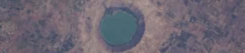
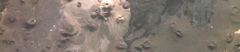
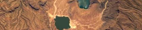
6 2 1 Geographic Location: CANADA Geographic Location: NAMIBIA Image ID#: ISS012 E Image ID#: ISS006 E This astronaut image is centered on the Manacouagan Impact Crater located in Quebec, Canada. The rim of the crater is now filled with water and referred to as the Manacouagan reservoir. Part of the central mound of the crater is still visible. OTHER VISIBLEFEATURE(S): Reservoir or lakes This astronaut image is taken of the Roter Kamm Impact Crater, found in the Namib Desert in Namibia. OTHER VISIBLE FEATURE(S): Sand dunes, mountains 4 3 Geographic Location: UNITED STATES Geographic Location: LIBYA Image ID#: ISS014 E Image ID#: ISS014 E This astronaut image is centered on Barringer Crater (also know as Meteor Crater) located in northern Arizona. It is one of the bestknown impact craters in the world. OTHER VISIBLE FEATURE(S): River channel, wind streak This astronaut image is centered on the Oasis Impact Crater found in the Sahara Desert in Libya. IMPACT FEATURES 6 5 Geographic Location: AUSTRALIA Geographic Location: ALGERIA Image ID#: ISS015 E Image ID#: ISS014 E This astronaut image is centered on Gosses Bluff, an impact crater located in Australia s Northern Territory. OTHER VISIBLE FEATURE(S): River channel This astronaut image shows the Quarkziz Impact Crater and sedimentary layers located in western Algeria close to the border of Morocco. OTHER VISIBLE FEATURE(S): Sedimentary rocks & layers, small circular hills 8 7 Geographic Location: INDIA Geographic Location: MAURITANIA Image ID#: ISS018 E Image ID#: ISS018 E This astronaut timage is centered on the Lonar Impact tcrater located This astronaut timage is centered on the Tenoumer Impact tcrater in Central India. The central portion of this crater is now filled with located in the Sahara Desert in Mauritania. water. OTHER VISIBLE FEATURE(S): Lake, agricultural fields, urban area


7 1 2 ISS013 E STS61A ISS016 E ISS016 E 8402 Expedition Earth and Beyond ARES Education Program Images courtesy of: Image Science & Analysis Laboratory VOLCANIC FEATURES 5 6 ISS018 E 6051 ISS017 E ISS017 E 5656 ISS016 E
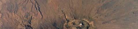
8 VOLCANIC FEATURE: VOLCANOES VOLCANIC FEATURE: VOLCANOES 2 1 Geographic Location: RUSSIA Geographic Location: UNITED STATES Image ID#: STS61A Image ID#: ISS013 E This astronaut image includes two of more than 100 volcanoes that exist in this region. These snow covered volcanoes are located in the Kamchatka Penninsula in Russia. This area is part of the Ring of Fire and has many active volcanoes. OTHER VISIBLEFEATURE(S): Caldera, lava drainage channels, snow, lake VOLCANIC FEATURES: VOLCANO, CALDERA, LAVA FLOWS Image ID#: ISS016 E 8402 This astronaut image captured the beginning of an eruption of a stratovolcano in Alaska called the Cleveland Volcano. Carlisle Island, another volcano, is visible in the upper left hand portion of the image. OTHER VISIBLE FEATURE(S): Ash plume, central vent, ocean, snow VOLCANIC FEATURES: VOLCANOES, LAVA FLOWS 4 3 Geographic Location: SAUDI ARABIA Image ID#: ISS016 E This astronaut image is taken of a volcanic field in Saudi Arabia. There are volcanoes of different sizes, shapes, and chemical compositions. This astronaut image shows the Emi Koussi Volcano located at the Lava flows vary in color. Features that look like impact craters were south end of the Tibesti Mountains in Chad. Extensive lava flows are actually caused by volcanic eruptions in the presence of water (some visible all around the volcano. of which are now filled with light colored sand and silt). VOLCANIC FEATURES VOLCANIC FEATURES: LAVA FLOWS, CALDERA VOLCANIC FEATURE: CALDERA 6 5 Geographic Location: SUDAN Image ID#: ISS018 E Geographic Location: UNITED STATES Image ID#: ISS017 E This astronaut timage shows lava flows on either side of the summit caldera of the tallest volcano on Earth. Mauna Loa, located on the Big Island of Hawaii rises ~9 km (~5.6 mi) above the sea floor. OTHER VISIBLE FEATURE(S): Clouds VOLCANIC FEATURE: LAVA FLOWS This astronaut images is taken of the Deriba Caldera, a dormant volcanic structure located at the top of the Marra Mountains in western Sudan. Numerous drainage networks are visible iibl around the caldera. Within the caldera are two inner volcanic depressions called craters. OTHER VISIBLE FEATURE(S): Drainage networks, inner crater lakes VOLCANIC FEATURE: LAVA FLOWS 8 7 Geographic Location: ETHIOPIA Image ID#: ISS016 E Image ID#: ISS017 E 5656 This astronaut image shows distinct, dark lava flows of the Tousside This astronaut image shows distinct, dark lava flows in the Afar Peak Volcano in Chad. The Tousside Peak Volcano (not shown in this volcanic region of Ethiopia. Although not visible in this image, three image) is the westernmost volcano of the Tibesti Mountains in large volcanoes are located to the north of these lava flows. northwestern Chad.
A bowl shaped depression formed by the collapse of a volcano is called a. Magma that has left the vent of a volcano is known as. Lava.
 Magma that has left the vent of a volcano is known as Lava A bowl shaped depression formed by the collapse of a volcano is called a Caldera This can form in a caldera when magma starts to come back up
Geologic Landforms Seen on Aerial Photos Instructor Notes
 1.5 hours Exercise Two Geologic Landforms Instructor Notes Suggested Correlation of Topics Geomorphology, gradation, impact cratering, tectonism, volcanism, photography Purpose The objective of this exercise
Physical Geology, 15/e
 Lecture Outlines Physical Geology, 15/e Plummer, Carlson & Hammersley Deserts & Wind Action Physical Geology 15/e, Chapter 13 Deserts Desert any arid region that receives less than 25 cm of precipitation
TAKE HOME EXAM 8R - Geology
 Name Period Date TAKE HOME EXAM 8R - Geology PART 1 - Multiple Choice 1. A volcanic cone made up of alternating layers of lava and rock particles is a cone. a. cinder b. lava c. shield d. composite 2.
UNIT 2 WARM UP. List the OCEANS. Bonus: Name the Largest LAKE on Earth
 UNIT 2 WARM UP List the OCEANS Bonus: Name the Largest LAKE on Earth Land Forms Land Mountain Hill Cliff Butte Mesa Plateau Cave Volcano Desert Plains Prairie Steppe Marsh Swamp Tundra Glacier Continent
Earth, the Lively* Planet. * not counting the life on the planet!
 Earth, the Lively* Planet * not counting the life on the planet! What We Will Learn Today What are planet Earth s features? What processes shape planetary surfaces? How does Earth s surface move? How did
Map Skills Test. 1. What do we call a person who makes maps? a. mapographer b. cartographer c. geologist d. archaeologist
 Map Skills Test 1. What do we call a person who makes maps? a. mapographer b. cartographer c. geologist d. archaeologist 2. What is the name of the 0 latitude line? a. Equator b. Arctic Circle c. First
discussion of North America s physical features, including its landforms and bodies of
 Chapter 7 Natural Environments of North America Chapter 7 focuses on the natural environments of North America. The chapter opens with a discussion of North America s physical features, including its landforms
Year 6. Geography. Revision
 Year 6 Geography Revision November 2017 Rivers and World knowledge How the water cycle works and the meaning of the terms evaporation, condensation, precipitation, transpiration, surface run-off, groundwater
CANADA S LANDFORM REGIONS
 CANADA S LANDFORM REGIONS Canada s Regions Canada is divided into Eight major regions. A Region is an area that is defined on the basis of the presence or absence of certain characteristics: Age of rock
South, Southeast, and East Asia. Physical Geography
 South, Southeast, and East Asia Physical Geography Mountains v Mountains are important in Asia because they influence: A. Population patterns B. Movement of people and goods C. Climate Mountains v The
WHAT IS THE EARTH MADE OF? LITHOSPHERE AND HYDROSPHERE
 UNIT 8 WHAT IS THE EARTH MADE OF? LITHOSPHERE AND HYDROSPHERE TABLE OF CONTENTS 1 THE STRUCTURE OF THE EARTH... 2 2 THE FORMATION OF THE RELIEF: INTERNAL AND EXTERNAL FORCES.... 2 2.1 Internal forces:
Earth s Layers. Earth s Surface
 CHAPTER 1 LESSON 3 Earth s Layers Earth s Surface Key Concepts What are Earth s major landforms and how do they compare? What are the major landform regions of the United States? What do you think? Read
What is a landform? These shapes (except for bodies of water) on the earth s surface are all examples of landforms.
 on the earth s surface are all examples of landforms.") Landforms What is a landform? These shapes (except for bodies of water) on the earth s surface are all examples of landforms. archipelago a large group of many islands. The Hawaiian Islands Lighthouse
Landforms What is a landform? These shapes (except for bodies of water) on the earth s surface are all examples of landforms. archipelago a large group of many islands. The Hawaiian Islands Lighthouse
12. The diagram below shows the collision of an oceanic plate and a continental plate.
 Review 1. Base your answer to the following question on the cross section below, which shows the boundary between two lithospheric plates. Point X is a location in the continental lithosphere. The depth
A ventifact. is a crescent-shaped sand dune lying at right angles to the prevailing wind.
 1. Match the definition to the process or landform. Hot environments processes and landforms is where unconsolidated, fine-grained particles are bounced along the ground by the wind. A ventifact is a form
COSMORPHOLOGY - May 2009
 Name COSMORPHOLOGY - May 2009 Geologic landforms Purpose: By studying aerial photographs you will learn to identify different kinds of geologic features based on their different morphologies and learn
A physical feature of the Earth s surface
 Earth s Landforms A physical feature of the Earth s surface A physical feature of the Earth s surface LANDFORM Highest of Earth s physical features Highest of Earth s physical features MOUNTAIN Low area
Unit 7.2 W.E.D. & Topography Test
 Name: Score: Unit 7.2 W.E.D. & Topography Test 1. 2. 3. 4. 5. 6. 7. 8. 9. 10. 11. 12. 13. 14. 15. 16. 17. 18. 19. 20. 21. 22. 23. 24. 25. 1. The formation of mountains is due mainly to while the destruction
Chapter 6, Part Colonizers arriving in North America found extremely landscapes. It looked different to region showing great.
 Social Studies 9 Unit 1 Worksheet Chapter 6, Part 1. 1. Colonizers arriving in North America found extremely landscapes. It looked different to region showing great. 2. The Earth is years old and is composed
netw rks Guided Reading Activity Essential Question: How does geography influence the way people live? Earth's Physical Geography
 Guided Reading Activity Lesson 1 Earth and the Sun Essential Question: How does geography influence the way people live? Looking at Earth Directions: What are the layers that make up Earth? Use your textbook
The structure of the Earth and how its motion creates the seasons. The landforms of the earth and the forces that shape the land.
 The structure of the Earth and how its motion creates the seasons. The landforms of the earth and the forces that shape the land. The role of wind and water in creating climate. The different climate and
Tropical Moist Rainforest
 Tropical or Lowlatitude Climates: Controlled by equatorial tropical air masses Tropical Moist Rainforest Rainfall is heavy in all months - more than 250 cm. (100 in.). Common temperatures of 27 C (80 F)
Chapter 1 Section 2. Land, Water, and Climate
 Chapter 1 Section 2 Land, Water, and Climate Vocabulary 1. Landforms- natural features of the Earth s land surface 2. Elevation- height above sea level 3. Relief- changes in height 4. Core- most inner
Examining the Terrestrial Planets (Chapter 20)
") GEOLOGY 306 Laboratory Instructor: TERRY J. BOROUGHS NAME: Examining the Terrestrial Planets (Chapter 20) For this assignment you will require: a calculator, colored pencils, a metric ruler, and your geology
GEOLOGY 306 Laboratory Instructor: TERRY J. BOROUGHS NAME: Examining the Terrestrial Planets (Chapter 20) For this assignment you will require: a calculator, colored pencils, a metric ruler, and your geology
 Page 1 of 9 Name: Base your answer to the question on the diagram below. The arrows show the direction in which sediment is being transported along the shoreline. A barrier beach has formed, creating a
Constructive and Destructive Forces. Processes That Act Upon Earth s Surface Features
 Constructive and Destructive Forces Processes That Act Upon Earth s Surface Features What are Constructive and Destructive Forces? Constructive Force A constructive force is a process that raises or builds
Physical Geography. Ariel view of the Amazon Rainforest. A Look at the Seven Continents
 Physical Geography In this unit you will learn about general physical geography. The study of the Earth s surface features provides the setting for the human-environmental interactions and for the human
(version 3) I. HumAN -Environment Interaction
 I. HumAN -Environment Interaction") (version 3) I. HumAN -Environment Interaction A. Landforms 1. Earth s topography is made up of many different types of landforms. 2. While the planet is covered primarily with water, the four major types
(version 3) I. HumAN -Environment Interaction A. Landforms 1. Earth s topography is made up of many different types of landforms. 2. While the planet is covered primarily with water, the four major types
Social Studies 9 UNIT 2 GEOGRAPHIC INFLUENCES ON IDENTITY: PLACE AND PEOPLE
 Social Studies 9 UNIT 2 GEOGRAPHIC INFLUENCES ON IDENTITY: PLACE AND PEOPLE The Structure of the Earth To understand the forces that create Canada's physical landscape we must understand the structure
Volcanoes. Presented by Kesler Science
 Presented by Kesler Science Essential Questions: 1. What are the parts of a volcano? 2. What are the four types? 3. What processes form volcanoes? 4. Where are volcanoes located on earth? What is a Volcano?
The Indian Ocean. Copyright 2010 LessonSnips
 The Indian Ocean One of the five major geographic divisions of the world s ocean, the Indian Ocean is located in the Eastern Hemisphere. The Indian Ocean is bounded by three continents: Africa to the west,
Read Across America. Listen as I read for facts about Volcanoes. In the Shadow of the Volcano
 Read Across America Listen as I read for facts about Volcanoes. In the Shadow of the Volcano Constructive & Destructive Processes Earth s surface is always changing. Blowing wind and flowing water causes
Chapter 1: The Geography of the Western Hemisphere
 Chapter 1: The Geography of the Western Hemisphere Chapter 1, Lesson 1: The Changing Earth Objectives: - You will be able to identify the major natural events that cause the earth to change. - You will
REFERENCE: The Blue Planet An Introduction to Earth System Science. Brian J. Skinner and Barbara W. Murck (2011) Third Edition. John Wiley and Sons
 Third Edition. John Wiley and Sons") REFERENCE: The Blue Planet An Introduction to Earth System Science. Brian J. Skinner and Barbara W. Murck (2011) Third Edition. John Wiley and Sons Inc. PLATE BOUNDARIES OCEAN FLOOR SEISMIC ACTIVITY WORLD'S
REFERENCE: The Blue Planet An Introduction to Earth System Science. Brian J. Skinner and Barbara W. Murck (2011) Third Edition. John Wiley and Sons Inc. PLATE BOUNDARIES OCEAN FLOOR SEISMIC ACTIVITY WORLD'S
7/4/2018. Deserts and Winds
 1 2 3 4 5 6 7 8 9 10 11 12 13 14 15 16 17 18 Deserts and Winds Earth Chapter 19 Chapter 19 Deserts & Winds What Is Meant by Dry? A dry climate is one where yearly precipitation is not as great as the potential
Volcanoes. Table of Contents Volcanoes and Plate Tectonics Volcanic Eruptions Volcanic Landforms
 Volcanoes Table of Contents Volcanoes and Plate Tectonics Volcanic Eruptions Volcanic Landforms What is a volcano? cone Conduit Or Pipe vent Side vent Central vent Crater A volcano is a vent or 'chimney'
Exploring Geography. Chapter 1
 Exploring Geography Chapter 1 The Study of Geography Geography is the study of where people, places, and things are located and how they relate to each other. Greek meaning writing about or describing
Developed in Consultation with Florida Educators
 Developed in Consultation with Florida Educators Table of Contents Next Generation Sunshine State Standards Correlation Chart... 7 Benchmarks Chapter 1 The Practice of Science...................... 11
4. The map below shows a meandering stream. Points A, B, C, and D represent locations along the stream bottom.
 1. Sediment is deposited as a river enters a lake because the A) velocity of the river decreases B) force of gravity decreases C) volume of water increases D) slope of the river increases 2. Which diagram
Geog Lecture 19
 Geog 1000 - Lecture 19 Fluvial Geomorphology and River Systems http://scholar.ulethbridge.ca/chasmer/classes/ Today s Lecture (Pgs 346 355) 1. What is Fluvial Geomorphology? 2. Hydrology and the Water
Name. 4. The diagram below shows a soil profile formed in an area of granite bedrock. Four different soil horizons, A, B, C, and D, are shown.
 Name 1. In the cross section of the hill shown below, which rock units are probably most resistant to weathering? 4. The diagram below shows a soil profile formed in an area of granite bedrock. Four different
Tips for Success on a Test
 Number of Incorrect: Final Grade: Parent Signature: Top Tips for Success on a Test 1. Read the following statements at least two times. 2. Circle the key words in each question/ or statement. (*Remember
Landscape. Review Note Cards
 Landscape Review Note Cards Last Ice Age Pleistocene Epoch that occurred about 22,000 Years ago Glacier A large, long lasting mass of ice which forms on land and moves downhill because of gravity. Continental
1. Which type of climate has the greatest amount of rock weathering caused by frost action? A) a wet climate in which temperatures remain below
 a wet climate in which temperatures remain below") 1. Which type of climate has the greatest amount of rock weathering caused by frost action? A) a wet climate in which temperatures remain below freezing B) a wet climate in which temperatures alternate
1. Which type of climate has the greatest amount of rock weathering caused by frost action? A) a wet climate in which temperatures remain below freezing B) a wet climate in which temperatures alternate
Chapter 2 Planet Earth
 Chapter 2 Planet Earth Section Notes Earth and the Sun s Energy Water on Earth The Land Close-up The Water Cycle World Almanac Major Eruptions in the Ring of Fire Quick Facts Chapter 2 Visual Summary Video
Introduction to Earth s s Spheres The Benchmark
 Introduction to Earth s s Spheres The Benchmark Volcanism Volcanic eruptions Effusive: lavas (e.g., Kilauea) Volcanism Volcanic eruptions Explosive: pyroclastic rocks (e.g., Krakatau) Factors Governing
Geology 0800 Review for Third Exam, Fall 2014 Please read all the questions very carefully.
 Geology 0800 Name Review for Third Exam, Fall 2014 Please read all the questions very carefully. 1. The slope of a stream bed measured at some point along its course is the. a. base level b. floodplain
Physical Geography A Living Planet
 Physical Geography A Living Planet The geography and structure of the earth are continually being changed by internal forces, like plate tectonics, and external forces, like the weather. Iguaçu Falls at
Chapter 21 Southwest Asia: Harsh & Arid Lands
 Name Hour Chapter 21 Southwest Asia: Harsh & Arid Lands Essential Question: How has the physical geography of Asia influenced the development of these regions (i.e. history, population distribution, &
Folding. Faulting. Volcanoes
 Folding Faulting Volcanoes Most major global mountain ranges were formed by the collision of continental (tectonic) plates Fold mountains are actually formed by crust which have been uplifted and folded
Volcanoes. Volcanic eruptions can be more powerful than the explosion of an atomic bomb.
 Ch. 13 Volcanoes Volcanoes Volcanic eruptions can be more powerful than the explosion of an atomic bomb. Many of these eruptions are caused by the movement of tectonic plates. Volcanism Volcanism-any activity
A. What is a volcano?
 VOLCANISM THE ROCK CYCLE I. Introduction From: Roman god of fire, Vulcan A. What is a volcano? A conical mountain formed around a vent where lava, pyroclastic materials, and gases are erupted. I. Introduction
Earth Structures and Processes Teacher Notes
 Aleutian Islands String of islands resulting from volcanic activity Part of the Pacific Ring of Fire Coast is very jagged and rocky with steep cliffs and mountains Underwater eruptions form new landforms
EXTERNAL LAND FORMING PROCESSES
 NAME SCHOOL INDEX NUMBER DATE EXTERNAL LAND FORMING PROCESSES WEATHERING 1 1998 Q 7 (a) (i) What is the difference between weathering and mass wasting (ii) List five processes involved in chemical weathering
UNIT 3 GEOLOGY VOCABULARY FLASHCARDS THESE KEY VOCABULARY WORDS AND PHRASES APPEAR ON THE UNIT 3 CBA
 UNIT 3 GEOLOGY VOCABULARY FLASHCARDS THESE KEY VOCABULARY WORDS AND PHRASES APPEAR ON THE UNIT 3 CBA A map that shows Earth s Topographic Map surface topography, which is Earth s shape and features Contour
What is the largest country in the world? Russia
 What is the largest country in the world? #1 Russia CSCOPE 2007 2 Russia Dimensions #2-3 Spans 11 Time Zones From East to West: Gulf of Finland to Alaska From North to South: Above the Arctic Circle to
6. In the diagram below, letters A and B represent locations near the edge of a continent.
 1. Base your answer to the following question on the cross section below and on your knowledge of Earth science. The cross section represents the distance and age of ocean-floor bedrock found on both sides
Effects of Eruptions. Most active in the world Kilauea, Hawaii.
 Inside of Old Smokey, All covered with snow, Lurk tons of hot magma, Getting ready to blow, Objectives: From deep in the chamber, Describe how volcanoes can affect people. Up a vent to the top, Describe
water erosion lithosphere Describe the process of erosion and deposition. chemical weathering Dissolving limestone is an example of.
 At one time, there was one large island off the coast of Mississippi and now it is two separate islands. What caused the island to be split into two? water erosion The crust and the top part of the upper
3/24/2016. Geology 12 Mr. M. Gauthier 24 March 2016
 Geology 12 Mr. M. Gauthier 24 March 2016 Introduction: Mt. St. Helens Before 1980 Mt. St Helens, in Southern Washington State, had not erupted since 1857 On March 27,1980 minor ashand eruptions were due
Unit 4 Lesson 4 Volcanoes. Copyright Houghton Mifflin Harcourt Publishing Company
 Magma Magic What is a volcano? A volcano is any place where gas, ash, or melted rock come out of the ground. Many volcanoes are dormant, meaning an eruption has not occurred in a long period of time. What
Automatic Recognition Of Crater-Like Structures In Terrestrial Images
 Automatic Recognition Of Crater-Like Structures In Terrestrial Images J.Earl 1, A.Chicarro 2, C.Koeberl 3, P.G.Marchetti 4, M.Milnes 1 22 nd March 2005 1 LogicaCMG UK (Space & Defence), 2 ESA/ESTEC Scientific
every continent has an extensive dry region! " deserts are as much as 1/3 of Earth s surface!
 deserts! deserts! every continent has an extensive dry region! " deserts are as much as 1/3 of Earth s surface! Hollywood portrayal of vast stretches of sand dune! " Sahara has only 10% covered by sand!
Refer to the map on page 173 to answer the following questions.
 Chapter 8-1 Plate Tectonics 1. Brainstorm the type of evidence that would indicate a climate change and how this evidence supports the theory of continental drift. Tropical fossils in cold regions Evidence
core mantle crust the center of the Earth the middle layer of the Earth made up of molten (melted) rock
 rock") core the center of the Earth mantle the middle layer of the Earth made up of molten (melted) rock crust the surface layer of the Earth that includes the continents and oceans 1 continental drift the theory
core the center of the Earth mantle the middle layer of the Earth made up of molten (melted) rock crust the surface layer of the Earth that includes the continents and oceans 1 continental drift the theory
A Living Planet. The Earth Inside and Out
 A Living Planet The Earth Inside and Out Planet Earth Earth s Rotation, Revolution, and Tilt Most of Earth s energy comes from the Sun, which we call solar energy. Imagine that the Earth has an imaginary
Glacial landscape. Arid Landscape. Geological feature. Extreme drainage. In this location you should find the following features:
 Glacial landscape In this location you should find the following features: Alluvial fan Braided river End moraines Glacial niche Talus cone U-valley Try to determine the altitude of the tree limit in the
Changes to the Earth Study Guide
 Changes to the Earth Study Guide Earth has a core, crust, and mantle. The core is made of a solid inner region and a liquid outer region. The mantle is the middle layer of earth made up of molten rock.
Impact Craters on Earth and in the Solar System
 Impact Craters on Earth and in the Solar System Christian KOEBERL Natural History Museum & University of Vienna, Austria The importance of impact cratering on terrestrial planets is obvious from the abundance
Major Domain of the Earth
 Major Domain of the Earth The surface of the earth is a complex zone in which three main components of the environment meet, overlap and interact. The solid portion of the earth on which we live is called
TABLE OF CONTENTS. Student Letter Exploring the Strategies Unit One: Play Unit Two: Fantasy Unit Three: Mystery...
 TABLE OF CONTENTS Student Letter........................................... 2 Exploring the Strategies................................... 3 Unit One: Play........................................... 4 Unit
Objectives: Describe how volcanoes can affect people. Describe conditions that cause volcanoes. Describe the relationship between volcanoes and Earth
 Objectives: Describe how volcanoes can affect people. Describe conditions that cause volcanoes. Describe the relationship between volcanoes and Earth s moving plates. Inside of Old Smokey, All covered
Science EOG Review: Landforms
 Mathematician Science EOG Review: Landforms Vocabulary Definition Term canyon deep, large, V- shaped valley formed by a river over millions of years of erosion; sometimes called gorges (example: Linville
Grade 9 Social Studies Canadian Identity. Chapter 2 Review Canada s Physical Landscape
 Grade 9 Social Studies Canadian Identity Chapter 2 Review Canada s Physical Landscape Name: Unit 1: Empowerment Terms (notes or textbook) 1. Core 2. Crust 3. Mantle 4. Magma 5. Continental drift 6. Plate
Name: Answer Key Date: Period:
 Name: Answer Key Date: Period: Earth Science Final Exam Study Guide Ch 1: Mapping 1. On the global grid, the equator is at 0 degrees. Is the equator a line of longitude or latitude? Latitude 2. What type
A) B) C) D) 4. Which diagram below best represents the pattern of magnetic orientation in the seafloor on the west (left) side of the ocean ridge?
 B) C) D) 4. Which diagram below best represents the pattern of magnetic orientation in the seafloor on the west (left) side of the ocean ridge?") 1. Crustal formation, which may cause the widening of an ocean, is most likely occurring at the boundary between the A) African Plate and the Eurasian Plate B) Pacific Plate and the Philippine Plate C)
1. Crustal formation, which may cause the widening of an ocean, is most likely occurring at the boundary between the A) African Plate and the Eurasian Plate B) Pacific Plate and the Philippine Plate C)
PHYSICAL GEOGRAPHY. By Brett Lucas
 PHYSICAL GEOGRAPHY By Brett Lucas FLUVIAL PROCESSES Fluvial Processes The Impact of Fluvial Processes on the Landscape Streams and Stream Systems Stream Channels Structural Relationships The Shaping and
27. Running Water I (p ; )
") 27. Running Water I (p. 424-436; 440-444) Hydrosphere How much of the Earth s surface is covered by water? Earth's water is collectively called the and is stored in a number of so-called as follows: 1.
27. Running Water I (p. 424-436; 440-444) Hydrosphere How much of the Earth s surface is covered by water? Earth's water is collectively called the and is stored in a number of so-called as follows: 1.
GLOBAL CLIMATES FOCUS
 which you will learn more about in Chapter 6. Refer to the climate map and chart on pages 28-29 as you read the rest of this chapter. FOCUS GLOBAL CLIMATES What are the major influences on climate? Where
with Mrs. Raup s Class
 with Mrs. Raup s Class 2005-06 Mt.Godwin(K2) Interesting Fact Did you know Mt. Godwin is the second highest peak in the world? Where? Mt.Godwin is located on the southern border of China near Pakistan.
OUR COUNTRY INDIA LOCATIONAL SETTING
 7 India is a country of vast geographical expanse. In the north, it is bound by the lofty Himalayas. The Arabian Sea in the west, the Bay of Bengal in the east and the Indian Ocean in the south, wash the
Chapter Twelve: Earthquakes
 The Changing Earth Chapter Twelve: Earthquakes 12.1 Earthquakes 12.2 Volcanoes Investigation 12B Volcanoes How are volcanoes and plate boundaries related? 12.2 Looking inside a volcano A volcano is where
Constructive & Destructive Forces
 Constructive & Destructive Forces Intro: Constructive Forces Processes that create landforms. Destructive Forces Processes that destroy landforms. Intro: Constructive Forces Volcanoes Deposition Landslides
What type of land feature is located at Point A? A Cliff B Delta C Mountain D Valley
 1 What type of land feature is located at Point A? A Cliff B Delta C Mountain D Valley Alfred Wegener s theory of continental drift was 2 not accepted by scientists when the theory was first proposed.
NATIONAL SPORTS SCHOOL ST BENEDICT COLLEGE
 NATIONAL SPORTS SCHOOL ST BENEDICT COLLEGE Mark HALF-YEARLY EXAMINATION 2013/14 FORM 2 GEOGRAPHY (Levels 8 7 6 5) TIME: 1h 30 min Name: Class: Answer ALL the questions. 1. TRUE or FALSE? Put a in the correct
Name Date Class. Directions: Use the diagram below to answer question Florida Progress Monitoring and Benchmark Assessments
 b e n c h m a r k t e s t : e a r t h a n d s p a c e s c i e n c e Multiple Choice 1. Geologists obtain indirect evidence about Earth s interior by A measuring pressure differences at Earth s surface.
Surface Events & Landforms. Mrs. Green
 Surface Events & Landforms Mrs. Green Bell Work 1) Which event MOST likely causes the slowest change to the surface of Earth? a) Earthquake b) Landslide c) Volcano d) Wind 2) When cold weather freezes
Changes to Land 5.7B. landforms: features on the surface of Earth such as mountains, hills, dunes, oceans and rivers
 All the landforms on Earth have changed over time and continue to change. Many of the changes were caused by wind, moving water, and moving ice. Mountains have grown and shrunk. Rivers have cut away land
3. The map below shows an eastern portion of North America. Points A and B represent locations on the eastern shoreline.
 1. Most tornadoes in the Northern Hemisphere are best described as violently rotating columns of air surrounded by A) clockwise surface winds moving toward the columns B) clockwise surface winds moving
LANDFORMS CREATED AND CHANGED?
 HOW ARE LANDFORMS CREATED AND CHANGED? Landforms are created by different natural forces. Some are within Earth, and some are on the surface of Earth. Landforms can also be changed by humans. These changes
Think about the landforms where you live. How do you think they have changed over time? How do you think they will change in the future?
 reflect All the landforms on Earth have changed over time and continue to change. Many of the changes were caused by wind, moving water, and moving ice. Mountains have grown and shrunk. Rivers have cut
The Sea Floor. Chapter 2
 The Sea Floor Chapter 2 Geography of the Ocean Basins World ocean is the predominant feature on the Earth in total area Northern Hemisphere = 61% of the total area is ocean. Southern Hemisphere = about
A Volcano is An opening in Earth s crust through
 Volcanoes A Volcano is An opening in Earth s crust through which molten rock, gases, and ash erupt. Also, the landform that develops around this opening. Kinds of Eruptions Geologists classify volcanic
Space. Earth. EARTH and EARTH and SPACE SPACE. Earth. William B. Rice
 Space Earth rth EARTH and EARTH and SPACE SPACE SCIENCE Earth is covered with mountains, canyons, and oceans. These landforms change over time. Mountains are made. Valleys may become deeper. Earth s landforms
Sample. Our Earth RED4001. Earth Science themes for 9 12 year olds. ISBN
 RED4001 Our Earth Earth Science themes for 9 12 year olds. Written by Judy Gabrovec. Illustrated by Melinda Parker. Typesetting and Design by Shay Howard. Published by Ready-Ed Publications (2006) Ready-Ed
Official languages: French and Arabic.
 Location: Chad is a landlocked Country located in the center of Africa, between 7 o and 23 o North Latitude, 13 o and 24 o East Longitude. Neighbour Country: Libya to the North; Central African Republic
Science Read. 10 July. About Volcanoes
 Issue 13 Science Read 10 July Career Guidance Interesting Science Real Life Application Real Time News Upper Secondary About Volcanoes U.S. Geological survey 14 December 2017 Volcanoes are openings, or
3.2 Notes: Volcanoes Form as Molten Rock Erupts
 3.2 Notes: Volcanoes Form as Molten Rock Erupts Think about What happens when a volcano erupts? Volcanoes erupt many types of material Earth s thin outer layer is, but most of Earth is extremely hot rock