ATTACHMENT F Transportation Management Plan
|
|
|
- Alexina Virginia Ford
- 6 years ago
- Views:
Transcription
1 ATTACHMENT F Transportation Management Plan
2 State of California DEPARTMENT OF TRANSPORTATION California State Transportation Agency TRANSPORTATION MANAGEMENT PLAN To: CARLON SCHRIEVE Date: January 22, 2016 Design Engineer File: DN-101 PM 13.4/22.8 District 1 Advance Planning EA: 01-0F280K EFIS: From: KEVIN CHURCH, Chief District 1 Office of Traffic Operations Project Information Location: Type of Work: Anticipated Traffic Control: Estimated Maximum Delay: Last Chance Grade In Del Norte County, near Crescent City, from 0.9 miles north of the Wilson Creek Bridge (# ) to Hamilton Rd. Construct a bypass. Reversing traffic control Intermittent closure Shoulder closure 10 minutes during flagging 25 minutes during intermittent closure 600 vph Peak Hour Traffic Volumes: Lane Requirement Charts Included: Yes Closure During Night Hours: Required during tie-ins Number of Working Days: 2 seasons PID Date: June 1, 2016 RTL Date: June 19, 2020 District Traffic Manager/ TMP Manager: Kevin Church (707) TMP Coordinator: Paul Hailey (707) Anticipated Traffic Impacts Significant traffic impacts are not anticipated provided that the following recommendations and requirements are incorporated into the project. In conformance with Deputy Directive-60, District Lane Closure Review Committee approval is not required for projects with anticipated traffic delay less than 30 minutes.
3 01-DN /22.8 January 22, F280K/ Page 2 Last Chance Grade Hours of Work See Chart no. 1 Conventional Highway Lane Requirements for work hour restrictions. The full width of the traveled way must be open for use by public traffic for the following Special Days: Event Event Date Special Days Sea Cruise First Weekend in October Friday through Sunday The contractor must verify the actual dates for this Special Event. See Chart no. 2 Lane Closure Restrictions for Designated Holidays and Special Days for work day restrictions. Public Notice Upon receipt of notice that the total roadway width, including paved shoulder, will be narrowed to less than 16 ft or there is a change in vertical clearance, the Resident Engineer must promptly notify the HQ District 1 Construction Liaison D Ann Watanabe-Gulling at (916) so annual permit holders can be notified of restrictions. The District Public Information Office, (707) , must be contacted two weeks in advance of the start of construction. Each closure must be entered in the Lane Closure System (LCS; Every Monday by noon, submit a schedule of planned closures for the next week period. The next week period is defined as Friday midnight through the following Friday midnight. Closures must be statused daily with first cone down (1097) and last cone up (1098) or cancelled (1022). Statusing can be accomplished through: Status With Day Time Contact Number LCS Any Any - District 1 Dispatch Monday-Friday 6am-6pm (707) District 3 Dispatch Monday-Friday 6pm-6am (916) District 3 Dispatch Saturday and Sunday Any (916) To access the LCS you will need an account. Contact Jeannette Candalot at (707) to get set up with an account.
4 01-DN /22.8 January 22, F280K/ Page 3 Last Chance Grade Any emergency service agency whose ability to respond to incidents will be affected by any lane closure must be notified prior to that closure. Impacts to tribal land during the construction phase must be coordinated with the affected local tribal government and other entities during the design phase. Contact Jaime Hostler, District 1 Native American Liaison, (707) Work must be coordinated with the local busing system (including school buses and public systems) to minimize impact on their bus schedules. The Resident Engineer must provide information to residents and businesses before and during project work that may represent a negative impact on commerce and travel surrounding the zone of construction. Funding must be included in supplemental funds for public information (Item Traffic Management Plan Public Information; consider $70,000). Consider incorporating supplemental funds into the cost estimate for this project for an open house public meeting prior to the construction phase. Regarding Traffic Management System (TMS) elements, provide Traffic Electrical and Traffic Census representatives 14 days notice before the preconstruction and post-construction operational status checks. Contact Traffic Electrical at (707) and Traffic Census at (707) Traffic Control One lane closure is permitted within the project limits. If stationary mounted construction area signs are used, the W11-1 vehicular traffic sign (bicycle symbol) and the W16-1p supplemental plaque (SHARE THE ROAD) must be placed, in each direction of travel, prior to the construction zone. Reversing traffic control must be in conformance with the attached traffic handling plan, Reversing Control THP. A minimum of 11 ft of paved roadway must be open for use by public traffic. The maximum length of a reversing traffic control closure is 2,500 ft. Advance flaggers are required during daylight hours. All flaggers must have continuous radio contact with personnel in the work area. Full matrix PCMS boards with the capability of displaying a flagger symbol must be used during hours of darkness when advance flaggers are not present.
5 01-DN /22.8 January 22, F280K/ Page 4 Last Chance Grade Work that requires a shoulder closure on a conventional highway with approach speeds greater than 50 mph must be in conformance with the Caltrans Revised Standard Plan T-10, TRAFFIC CONTROL SYSTEM FOR LANE CLOSURE ON FREEWAYS AND EXPRESSWAYS. Work that requires a lane closure on a multilane conventional highway with approach speeds greater than 50 mph must be in conformance with the Caltrans Revised Standard Plan T-10, TRAFFIC CONTROL SYSTEM FOR LANE CLOSURE ON FREEWAYS AND EXPRESSWAYS. A minimum of 14 ft of paved roadway in each direction of travel must be open for use by public traffic. During the construction of tie-ins between the new bypass and existing Route 101, when reversing traffic control is in effect, the road may be closed and public traffic stopped for periods not to exceed 15 min. After each closure, all accumulated traffic must be allowed to pass through the work before another closure is made. A minimum of one PCMS in advance of both ends of the construction site must be required to notify the public of the closures related to this project. Start displaying the message on the PCMS 15 minutes before closing the lane. Access to businesses, side roads and residences must be maintained at all times. When work or traffic queues extend through an intersection, additional traffic control will be required at the intersection. This section of Highway 101 is part of the Pacific Coast Bike Route. Bicyclists must be accommodated through the work zone. Signage must be used to alert vehicles of the possible presence of bicyclists. During reversing traffic control, bicyclists must be instructed to join the vehicle queue. During lane reduction traffic control, bicyclists must be provided space adjacent to the open traffic lane to traverse through the work zone. COZEEP is required for this project during the construction of tie-ins between the new bypass and existing Route 101. The COZEEP requirement is based on risk factors associated with this project and the COZEEP Guidelines (CA DOT Construction Manual Section 2-215C). The associated risk factors include: workers exposed to traffic, night construction activities, speed management, and significant truck volumes. The following table lists projects that are anticipated to have closures near this project and must be used to assess cumulative corridor delay.
6 01-DN /22.8 January 22, F280K/ Page 5 Last Chance Grade Contract No. Co-Rte-PM Type of Work Est. Delay (min) 01-0B0904 DN-101-R8.2/8.7 Replace 2 Bridges C6604 DN /27.3 Crescent City Gateway TBD 01-0F3104 DN Construct Bridge F6104 DN Construct bridge 0 (Lane Reduction) DN /36.5 Bridge Replacement 10 Contingency Plan The contractor must prepare a contingency plan for reopening closures to public traffic. The Contractor must submit the contingency plan for a given operation to the Engineer within one working day of the Engineer s request. Contingencies for unanticipated delays, emergencies, etc. must be coordinated between the RE and the Contractor. Approval Approved by: Approved by: Transportation Management Plan Coordinator District Traffic/ TMP Manager KBC/jnl CC: 1)KBChurch, 2)JCandalot SCohen THodgson JMcGee Traffic Safety PIO
7 01-DN /22.8 January 22, F280K/ Page 6 Last Chance Grade Chart no. 1 Conventional Highway Lane Requirements County: Del Norte Route/Direction: 101 NB/SB PM: 13.4/22.8 Closure limits: From hour to hour Mondays through Thursdays I I I I I I I R R R R R R R R R R R R R I I I I Fridays Saturdays I I I I I I I R R R R R R R R Sundays I I I I Legend: Provide at least one 11 ft through traffic lane for use by both directions of travel (Reversing Control). The R maximum closure length is 2,500 ft. I Provide at least one 11 ft through traffic lane for use by both directions of travel (Reversing Control). The maximum closure length is 2,500 ft. A 15 minute intermittent closure is allowed during the tie-in of the new bypass to existing Route 101. No lane and/or shoulder closures allowed. REMARKS: The full width of the traveled way must be open for use by public traffic when construction operations are not actively in progress.
8 01-DN /22.8 January 22, F280K/ Page 7 Last Chance Grade Chart no. 2: Lane Closure Restrictions for Designated Holidays and Special Days Thu Fri Sat Sun Mon Tues Wed Thu Fri Sat Sun H SD H SD H SD H Legend: Refer to lane requirement charts The full width of the traveled way must be open for use by public traffic. H Designated Holiday SD Special Day H H H
9 01-DN /22.8 January 22, F280K/ Page 8 Last Chance Grade
10 ATTACHMENT G Preliminary Geotechnical Report
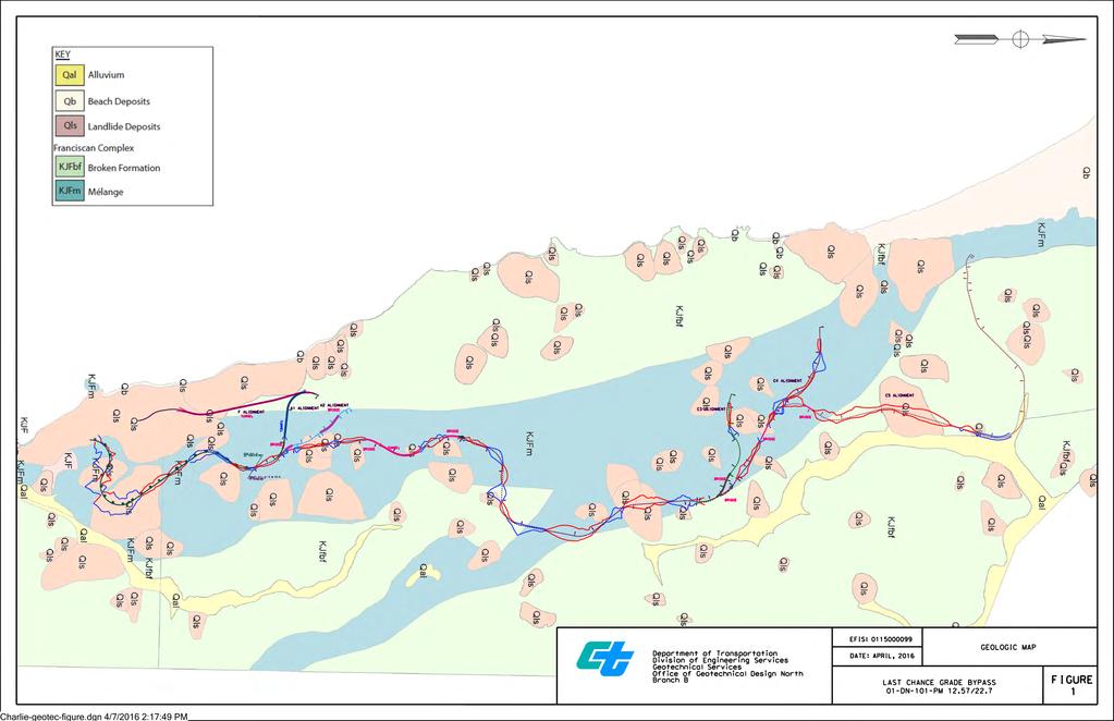
11 State of California DEPARMENT OF TRANSPORTATION Business, Transportation and Housing Agency M e m o r a n d u m Serious drought. Help Save Water! To: Talitha Hodgson Date: April 08, 2016 Project Manager File: 01-DN-101-PM 12.0/15.5 EA: 01-0F280K EFIS ID: Last Chance Grade Bypass Attn: Jeffrey Pimentel, Project Engineer Advance Planning From: DEPARTMENT OF TRANSPORTATION DIVISION OF ENGINEERING SERVICES GEOTECHNICAL SERVICES OFFICE OF GEOTECHNICAL DESIGN WEST Subject: Preliminary Geotechnical Report for Last Chance Grade Bypass 1. Introduction This memorandum summarizes the results of a preliminary geotechnical evaluation of six alternative alignments of Highway 101 currently being considered in order to bypass Last Chance Grade in Del Norte County. The bypass alternatives are A-1, A-2, F, C-3, C-4, and C-5. A map showing the location of the proposed alternatives is provided in Attachment A. A layout and profile of the existing alignment is provided in Attachment B. Plan maps and profiles of the six alternatives are provided in Attachments C, D, E, and F1 through F4. The information contained in this memorandum is based on a review of existing Caltrans reports, California Geological Survey Special Report 184 (Wills, 2000), existing geomorphic maps, a landslide map provided by Green Diamond Resource Company, and plan maps, profiles and typical cross sections of the proposed alignments. No field investigation was conducted in preparation of this Memorandum. Preliminary foundation recommendations for the bridges along the proposed alignments are provided in the Structures Preliminary Geotechnical Report for Last Chance Grade Bypass dated February 24 th, Provide a safe, sustainable, integrated and efficient transportation system to enhance California s economy and livability
12 Talitha Hodgson 01-DN-101-PM April 08, 2017 EFIS: Site Geology California Geological Survey Special Report 184, Landslides in the Highway 101 Corridor between Wilson Creek and Crescent City, Del Norte County, California (2000) includes geologic and landslide maps that encompass the proposed alignments. The maps are based on a compilation of previous mapping, interpretation of aerial photographs and field mapping. The landslides identified in the landslide map are classified and mapped based on their geomorphology. Detailed geotechnical data required to evaluate the probability of movement of the landslides was not collected as part of the investigation. A geologic map showing the proposed alignments is provided in Figure 1. The geologic map indicates bedrock beneath the proposed alignments is either Franciscan Complex Broken Formation or Melange. The Broken formation typically consists of hard sandstone blocks separated by weak beds of shale and shear zones. Landslides within the Broken formation tend to be deep seated. The Northern and Southern Last Chance Grade Landslides along the existing alignment are located within the Broken Formation. The Melange typically consists of highly sheared shale and argillite. Landslides in the Melange are typically earthflows. The existing alignment between Wilson Creek (PM 12.7) and approximately PM 14.4 is located within the limits of an active earthflow. A geologic map showing geomorphic features related to landsliding is provided in Figure 2. The map shows the locations of what are interpreted to be landslides as well as amphitheater slopes, features formed by landslide processes. The map also depicts disrupted ground, irregular ground surfaces formed by complex landsliding. 3. Geotechnical Investigation A preliminary geotechnical investigation will be required in order to evaluate the feasibility of the proposed alignments based on geotechnical considerations and develop preliminary recommendations. Initially the investigation will be focused in areas of known or probable instability to aid in determining the extent to which landslide mitigation may be required. Geotechnical information collected during the preliminary investigation will aid in determining the preferred alternative or alternatives. Additional field investigation will be required during the design phase of the project in order to develop final geotechnical recommendations for the planned alternative. The geotechnical investigation will include field mapping, geotechnical drilling, instrumentation and monitoring, seismic refraction surveys, and laboratory testing. Where possible, geotechnical drilling will occur on existing park and logging roads that intersect or are in close proximity to the alternative alignments. Temporary access roads will be constructed to access some locations. Helicopters will be required to transport drilling equipment to areas where access is restricted. We recommend that airborne Lidar be collected along the alignments of the proposed alternatives. High-resolution digital elevation maps generated by airborne Lidar will facilitate Provide a safe, sustainable, integrated and efficient transportation system to enhance California s economy and livability
13 Talitha Hodgson 01-DN-101-PM April 08, 2017 EFIS: geologic and geomorphic mapping and identifying areas where detailed field investigations are warranted. A resource estimate for Geotechnical Services for the preliminary geotechnical investigation will be provided in a separate memorandum. 4. Discussion of Alternatives Existing Alignment The existing alignment between Wilson Creek (PM 12.7) and approximately PM 14.4 is within the limits of an active earthflow and requires frequent grinding and paving due to ongoing deformation of the roadway. The proposed alternatives do not bypass the earthflow. The existing alignment within the limits of the earthflow will still need to be maintained after the bypass is constructed. Geologic mapping of this area and a subsurface investigation including instrumentation and monitoring should be considered in order to evaluate options for mitigation of the earthflow. Alternatives A-1, A-2 and C3-C5 All the alternatives with the exception of Alternative F, have the same alignment between Station 0+00 and approximately Station Between Station 0+00 and approximately Station 16+00, Alternatives A-1, A-2, and C3-C5 are located within the limits of an active earthflow. The proposed roadway will be prone to deformation similar to what is occurring along the existing alignment between PM 12.7 and Investigation of this area will be required in order to evaluate options for mitigation of the earthflow. Alternatives A-1, A-2, and C3-C5 between approximately Station and Station are located within the limits of what are mapped as probable dormant mature landslides. Large cuts and fills are proposed throughout this section. In addition to the landslides located between Stations and 76+00, alternatives A-1, A-2 and C3-C5 traverse numerous mapped landslides along the proposed alignments. With the exception of the existing active earthflow located between Stations 0+00 and 16+00, almost all the landslides that the proposed alignments traverse are mapped as probable or questionable, dormant-mature, deep ( >50 feet) rockslides. Whether or not landslide mitigation will be required for a given landslide will depend on the stability of the existing slope, the magnitude of the proposed cuts and fills within the limits of the mapped landslide and the location of the cuts and fills with respect to the head or toe of the landslide. Areas of known or probable instability along the proposed alignments will be investigated in order to determine if landslide mitigation is required. Based on existing geologic mapping and review of preliminary cross sections, the alignment of the tunnel proposed in Alternative A-1 is outside the limits of the Northern Last Chance Grade Provide a safe, sustainable, integrated and efficient transportation system to enhance California s economy and livability

14 Talitha Hodgson 01-DN-101-PM April 08, 2017 EFIS: Landslide. A detailed field investigation will be required in order to verify the location of the proposed tunnel with respect to the Northern Last Chance Grade Landslide. Alternative F Alternative F is a tunnel alignment that parallels the existing highway. Alternative F departs the existing alignment at approximately PM Based on existing geologic mapping and a review of preliminary cross sections, the tunnel is outside the limits of the Wilson Creek Landslide and the Southern and Northern Last Chance Grade Landslides. However, the southern portal and a portion of the tunnel are within the limits of an active earthflow. A detailed field investigation will be required in order to verify the location of the tunnel with respect to the aforementioned landslides and to evaluate options for stabilization the earthflow. This alternative may not be viable unless the potential impacts of the earthflow can be mitigated. If you have any questions or require additional assistance, please contact me at (707) CHARLIE NARWOLD Senior Engineering Geologist Office of Geotechnical Design West Branch F References Davenport, C.W., 1984, DMG Open-File Report 84-07, Geology and Geomorphic Features Related to Landsliding, Childs Hill 7.5' Quadrangle, Del Norte County, California Scale 1:24,000. Davenport, C.W., 1984, DMG Open-File Report 84-08, Geology and Geomorphic Features Related to Landsliding, Requa 7.5' Quadrangle, Del Norte County, California Scale 1:24,000. Wills, C. J., California Geological Survey Special Report 184, Landslides in the Highway 101 Corridor between Wilson Creek and Crescent City, Del Norte County, California, List of Figures Figure 1 - Geologic Map. Figure 2 - Geomorphic Map. Provide a safe, sustainable, integrated and efficient transportation system to enhance California s economy and livability
15 Talitha Hodgson 01-DN-101-PM April 08, 2017 EFIS: Attachments Attachment A - Location Map Attachment B - Layout and Profile of Existing Grade Attachment C - Layout and Profile Alternative A-1 Attachment D - Layout and Profile Alternative A-2 Attachment E - Layout and Profile Alternative F Attachment F1 - Layout and Profile Alternatives C3, C4, and C5 Sheet 1 of 4 Attachment F2 - Layout and Profile Alternative C3, C4, and C5 Sheet 2 of 4 Attachment F3 - Layout and Profile Alternative C3, C4, and C5 Sheet 3 of 4 Attachment F4 - Layout and Profile Alternative C3, C4, and C5 Sheet 4 of 4 C: Project File Provide a safe, sustainable, integrated and efficient transportation system to enhance California s economy and livability

16


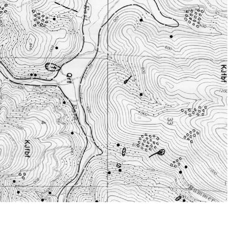


17 Note: alignments are slightly offset with respect to the underlying topographic map. LastChanceGEO2-t.dgn 4/7/2016 6:26:25 PM
City of Saginaw Right of Way Division Snow and Ice Removal Policy January 18, 2016
 Snow and Ice Removal Policy January 18, 2016 It is the policy of the to provide snowplowing and ice removal services in order to: Provide safe traveling conditions for motorists and pedestrians Assist
IOWA COUNTY ORDINANCE NO. 22 IOWA COUNTY SNOW & ICE POLICY
 IOWA COUNTY ORDINANCE NO. 22 IOWA COUNTY SNOW & ICE POLICY AN ORDINANCE REPEALING ESTABLISHING THE POLICY AND LEVEL OF SERVICE IN RESPECT TO CLEARANCE OF SNOW AND ICE AND MAINTENANCE OF IOWA COUNTY S SECONDARY
WEBER ROAD RESIDENTIAL DEVELOPMENT Single Family Residential Project
 WEBER ROAD RESIDENTIAL DEVELOPMENT Single Family Residential Project WEBER ROAD RESIDENTIAL DEVELOPMENT TRAFFIC IMPACT STUDY TABLE OF CONTENTS 1.0 Executive Summary Page 2.0 Introduction 2.1 DEVELOPMENT
CITY OF MINOT SNOW REMOVAL PLAN October 2018
 CITY OF MINOT SNOW REMOVAL PLAN October 2018 1.0 GENERAL This plan has been written to provide information regarding snow removal procedures and policies. The plan provides guidance, while maintaining
April 10, Mr. Curt Van De Walle, City Manager City of Castle Hills 209 Lemonwood Drive Castle Hills, Texas 78213
 Mr. Curt Van De Walle, City Manager City of Castle Hills 209 Lemonwood Drive Castle Hills, Texas 78213 Subject: Revised Castle Hills BASIS Charter School Traffic Impact Analysis Review City of Castle Hills,
Dunn County Snow Removal Policy
 Dunn County Snow Removal Policy OVERVIEW With the advent of another winter season in the northern plains comes the possibility of snow, freezing rain and slippery roadways, and area resident s concern
SLOPE STABILITY EVALUATION AND ACCEPTANCE STANDARDS
 INFORMATION BULLETIN / PUBLIC - BUILDING CODE REFERENCE NO.: LABC 7006.3, 7014.1 Effective: 01-01-2017 DOCUMENT NO.: P/BC 2017-049 Revised: 12-21-2016 Previously Issued As: P/BC 2014-049 SLOPE STABILITY
PW 001 SNOW REMOVAL AND SANDING FOR ROADWAYS AND SIDEWALKS October 6, 2014 (#223-14) Original October 19, 2015; October 15, 2018 Public Works
 Original October 19, 2015; October 15, 2018 Public Works") Policy Statement: The Village of Kitscoty will provide snow and ice control on municipal streets and sidewalks according to determined priorities. Purpose: To provide direction and information to employees
Policy Statement: The Village of Kitscoty will provide snow and ice control on municipal streets and sidewalks according to determined priorities. Purpose: To provide direction and information to employees
SLOPE STABILITY EVALUATION AND ACCEPTANCE STANDARDS
 INFORMATION BULLETIN / PUBLIC - BUILDING CODE REFERENCE NO.: LAMC 98.0508 Effective: 1-26-84 DOCUMENT NO. P/BC 2002-049 Revised: 11-1-02 Previously Issued As: RGA #1-84 SLOPE STABILITY EVALUATION AND ACCEPTANCE
Monroe County: Key West and Lower Keys
 FDOT PROJECT UPDATES June 15-21, 2015 Monroe County: Key West and Lower Keys Monroe County projects website: www.fdotmonroe.com Opt Out: If you no longer wish to receive these weekly notifications, please
Expanding the GSATS Model Area into
 Appendix A Expanding the GSATS Model Area into North Carolina Jluy, 2011 Table of Contents LONG-RANGE TRANSPORTATION PLAN UPDATE 1. Introduction... 1 1.1 Background... 1 1.2 Existing Northern Extent of
SNOW CONTROL OPERATIONS 2017 PUBLIC SERVICES DEPARTMENT MAINTENANCE DIVISION
 SNOW CONTROL OPERATIONS 2017 PUBLIC SERVICES DEPARTMENT MAINTENANCE DIVISION 1 SNOW CONTROL OPERATIONS The following are the standard operating procedures f snow removal operations. 1. Plowing operations
Flood Scenario Worksheet
 Flood Scenario Worksheet Scenario adapted from: http://www.epa.gov/watersecurity/tools/trainingcd/simple/source/scenario-8/ssc8-0.pdf Simple Tabletop Exercise, Interdependency Natural Disaster Scenario,
OXFORD HEIGHTS SUBDIVISION EMERGENCY EVACUATION PLAN
 OXFORD HEIGHTS SUBDIVISION EMERGENCY EVACUATION PLAN March 27, 2007 Oxford Heights Overview and Historical Conditions Oxford Heights is a medium sized community located on the southern side of Elizabeth
Date: June 19, 2013 Meeting Date: July 5, Consideration of the City of Vancouver s Regional Context Statement
 Section E 1.5 To: From: Regional Planning and Agriculture Committee Lee-Ann Garnett, Senior Regional Planner Planning, Policy and Environment Department Date: June 19, 2013 Meeting Date: July 5, 2013 Subject:
Geology, Soils, and Seismicity
 Section 3.8 Geology, Soils, and Seismicity Introduction This section generally evaluates the effects of the alternatives analyzed in this Supplemental DEIS with regard to geology, soils and seismicity.
COUNCIL POLICY MANUAL
 COUNCIL POLICY MANUAL SECTION: PUBLIC WORKS SUBJECT: SNOW & ICE CONTROL POLICY 2012/2013 GOAL: Pages: 1 of 10 Approval Date: Dec. 3, 2012 Res. # 1001/2012 To annually identify the winter maintenance costs
CITY OF NEW LONDON WINTER ROAD & SIDEWALK MAINTENANCE POLICY
 CITY OF NEW LONDON WINTER ROAD & SIDEWALK MAINTENANCE POLICY GENERAL The purpose of this policy is to set up acceptable procedures and policies for the winter maintenance of public areas in the City of
Guidelines for Site-Specific Seismic Hazard Reports for Essential and Hazardous Facilities and Major and Special-Occupancy Structures in Oregon
 Guidelines for Site-Specific Seismic Hazard Reports for Essential and Hazardous Facilities and Major and Special-Occupancy Structures in Oregon By the Oregon Board of Geologist Examiners and the Oregon
INCLEMENT WEATHER CLOSING CODES
 INCLEMENT WEATHER CLOSING CODES Code 0 Code 1 Code 2 Code 3 Code 4 Code 5 Code 6 ALL operations are closed and no employees should report to work. Transportation personnel, maintenance personnel, ALL custodial
JEP John E. Jack Pflum, P.E. Consulting Engineering 7541 Hosbrook Road, Cincinnati, OH Telephone:
 JEP John E. Jack Pflum, P.E. Consulting Engineering 7541 Hosbrook Road, Cincinnati, OH 45243 Email: jackpflum1@gmail.com Telephone: 513.919.7814 MEMORANDUM REPORT Traffic Impact Analysis Proposed Soccer
SNOW REMOVAL POLICY ITASCA COUNTY TRANSPORTATION DEPARTMENT
 ITASCA COUNTY TRANSPORTATION DEPARTMENT Effective Date: November 1, 1989 Revised: November 18, 2014 Policy Number: Operations 89-4 Distribution: Commissioner's Office Engineer's Office All Garages Number
Appendix C Final Methods and Assumptions for Forecasting Traffic Volumes
 Fairview Ave. and Main St. Improvements and Local Streets Plan Appendices Ada County Highway District Appendix C Final Methods and Assumptions for Forecasting Traffic Volumes January 3, 207 Appendices
2. Initial Summary of Preliminary Expert Opinion of Converse and Psomas Reports
 UNITED WALNUT TAXPAYERS PRELIMINARY REVIEW OF NEGATIVE GEOTECHNICAL AND GEOLOGICAL ASPECTS OF CONSTRUCTING EARTHFILL PAD FOR A SOLAR FARM ON THE WEST PARCEL - DRAFT 1. Introduction A licensed Engineering
MUNICIPALITY OF ANCHORAGE PUBLIC TRANSPORTATION DEPARTMENT AnchorRIDES TRANSPORTATION SYSTEM
 Purpose: The Public Transportation Department and contracted provider will provide safe transportation for AnchorRIDES customers and employees during severe weather or emergency conditions. AnchorRIDES
NATHAN HALE HIGH SCHOOL PARKING AND TRAFFIC ANALYSIS. Table of Contents
 Parking and Traffic Analysis Seattle, WA Prepared for: URS Corporation 1501 4th Avenue, Suite 1400 Seattle, WA 98101-1616 Prepared by: Mirai Transportation Planning & Engineering 11410 NE 122nd Way, Suite
TRAFFIC ALERT FOR WEEK OF February 4 8, 2008
 TRAFFIC ALERT FOR WEEK OF February 4 8, 2008 Highway work zones in the Staunton District The following is a list of highway work that might affect traffic in the Staunton transportation district during
GUIDELINES FOR FILMING IN TOMBALL, TEXAS
 GUIDELINES FOR FILMING IN TOMBALL, TEXAS I. PURPOSE The following guidelines are intended to protect the personal and property rights of our Tomball, Texas residents and businesses. The City Manager reserves
SNOW REMOVAL - REQUEST FOR PROPOSAL. Snow Removal/Clearing and Sanding/Salting for Winter Fundy Ocean Research Center for Energy
 Fundy Ocean Research Center for Energy SNOW REMOVAL - REQUEST FOR PROPOSAL Snow Removal/Clearing and Sanding/Salting for Winter 2016-17 Sites 1. FORCE Sub-Station Driveway (portion of Old Black Rock Road),
OREGON DEPARTMENT OF TRANSPORTATION STATEWIDE ROAD, WEATHER AND INCIDENT CONDITIONS 4/22/2019 4:20:05 AM
 OREGON DEPARTMENT OF TRANSPORTATION STATEWIDE ROAD, WEATHER AND INCIDENT CONDITIONS Incidents/: 4/22/2019 4:20:05 AM HWY372 22 22 Mount Bachelor Ski Area I-5 10 13 5 Mi S of Ashland Informational only
THE NEW DNR LANDSLIDE HAZARDS PROGRAM
 THE NEW DNR LANDSLIDE HAZARDS PROGRAM Kara Jacobacci, G.I.T. Landslide Hazards Program Washington Geological Survey Washington Department of Natural Resources LEGISLATIVE FUNDING 2015 session DNR requested
CITY OF MINOT SNOW REMOVAL PLAN November 2017
 CITY OF MINOT SNOW REMOVAL PLAN November 2017 1.0 GENERAL This plan has been written to provide information regarding snow removal procedures and policies. The plan provides guidance, while maintaining
Brea Olinda Unified School District
 Brea Olinda Unified School District Updated May 2, 2011 Olinda School Frequently Asked Questions 1. Will the new school will be breaking ground this Fall? YES! BOUSD held the Groundbreaking Ceremony on
Annual Collision Report
 2016 Annual Collision Report Contents The Annual Collision Report is a summary of statistics associated with traffic collisions that occurred in the City of Winnipeg. This information is provided by Manitoba
SNOW CONTROL OPERATIONS
 SNOW CONTROL OPERATIONS PUBLIC WORKS TEAM STREET MAINTENANCE DIVISION SNOW CONTROL OPERATIONS Standard Operating Procedures for Snow Removal Operations. 1. Plowing operations will be initiated when snow
CITY OF EAST PEORIA SNOW AND ICE CONTROL PROGRAM INTRODUCTION
 CITY OF EAST PEORIA SNOW AND ICE CONTROL PROGRAM INTRODUCTION The responsibility for providing snow and ice control on East Peoria s 240 lane miles of streets and alleys rests with the Street Divisions
Resolution Number: (2) Resolution Title: Snow Policy Date Signed: 11/26/12. DAVIS COUNTY Snow Policy Resolution
 Resolution Title: Snow Policy Date Signed: 11/26/12. DAVIS COUNTY Snow Policy Resolution") Resolution Number: 112612(2) Resolution Title: Snow Policy Signed: 11/26/12 DAVIS COUNTY Snow Policy Resolution A RESOLUTION TO ESTABLISH THE POLICY AND LEVEL OF SERVICE IN RESPECT TO CLEARANCE OF SNOW
Resolution Number: 112612(2) Resolution Title: Snow Policy Signed: 11/26/12 DAVIS COUNTY Snow Policy Resolution A RESOLUTION TO ESTABLISH THE POLICY AND LEVEL OF SERVICE IN RESPECT TO CLEARANCE OF SNOW
Tahlequah Public Schools Inclement Weather Transportation Plan
 Tahlequah Public Schools Inclement Weather Transportation Plan Inclement Weather with Ice and Snow From time to time throughout the school year, weather may force a change in the District s normal operating
Subject: Desert Palisades Specific Plan - Tram Way Access Sight Distance
 Endo Engineering Traffic Engineering Air Quality Studies Noise Assessments July 13, 2015 Mr. Ed Freeman Pinnacle View, LLC P.O. Box 1754 Lake Oswego, OR 97035-0579 Subject: Desert Palisades Specific Plan
WEEKLY WEATHER OUTLOOK BELIZE, CENTRAL AMERICA
 WEEKLY WEATHER OUTLOOK BELIZE, CENTRAL AMERICA PERIOD: Sunday, July 1 until Monday, July 9, 2012 DATE ISSUED: Sunday, July 1, 2012 3:00 pm RFrutos EcoSolutions & Services SYNOPSIS: The features of interest
Mountain View Community Shuttle Monthly Operations Report
 Mountain View Community Shuttle Monthly Operations Report October 9, 2018 Contents Passengers per Day, Table...- 3 - Passengers per Day, Chart...- 3 - Ridership Year-To-Date...- 4 - Average Daily Ridership
Temporary College Closure Due to Inclement Weather or Other Adverse Conditions.
 OTHER TOPICS Index No. X-1 PROCEDURES MEMORANDUM TO: FROM: SUBJECT: MCC Students and Staff Office of the President Temporary College Closure Due to Inclement Weather or Other Adverse Conditions. DATE:
GREEN SHEET. California Department of Forestry and Fire Protection (CAL FIRE)
") GREEN SHEET California Department of Forestry and Fire Protection (CAL FIRE) Informational Summary Report of Serious CAL FIRE Injuries, Illnesses, Accidents and Near Serious Accidents Fire Engine Rollover
GREEN SHEET California Department of Forestry and Fire Protection (CAL FIRE) Informational Summary Report of Serious CAL FIRE Injuries, Illnesses, Accidents and Near Serious Accidents Fire Engine Rollover
CITY OF ORILLIA POLICY MANUAL. Winter Operations. Table of Contents. WINTER CONTROL Objectives 2. WINTER CONTROL Season 3
 Page 1 of 12 Winter Operations Table of Contents WINTER CONTROL Objectives 2 WINTER CONTROL Season 3 SNOW ACCUMULATION Road Plowing 4,5 ICY ROADWAYS Application of Deicers/Abrasives 6 SNOW ACCUMULATION
MONTGOMERY COUNTY SNOW PLAN
 2018 2019 MONTGOMERY COUNTY SNOW PLAN COMMUNICATION DURING SNOW/ICE SITUATIONS Communication will be established prior/during all winter storms between the Sheriff s Office, Public Works Department, and
Focused Traffic Analysis for the One Lincoln Park Project
 September 15, 2015 Mr. Bill Johnson Coldwell Banker 511 Sir Francis Drake Boulevard Greenbrae, CA 94904 Focused Traffic Analysis for the One Lincoln Park Project Dear Mr. Johnson; As requested, W-Trans
California Urban Infill Trip Generation Study. Jim Daisa, P.E.
 California Urban Infill Trip Generation Study Jim Daisa, P.E. What We Did in the Study Develop trip generation rates for land uses in urban areas of California Establish a California urban land use trip
City of Laramie, Wyoming SNOW AND ICE POLICY
 City of Laramie, Wyoming SNOW AND ICE POLICY 11/02/89; rev 10/15/2007 I. INTRODUCTION The intention of this Policy is to set reasonable goals and general practices as a guide for the conduct of snow and
Organized Chain-Up and VSL
 Organized Chain-Up and VSL Jim Mahugh, PE WSDOT SC Region Traffic Engineer North/West Passage VSL Peer Exchange January 28, 2015 Snoqualmie Pass 2 Limits of VSL EB: MP 48.12 to 66.56 WB: MP 46.69 to 66.90
AASHTO Committee on Maintenance 2018 Annual Meeting July 25, Hurricane Irma- Preparation and Response
 AASHTO Committee on Maintenance 2018 Annual Meeting July 25, 2018 Hurricane Irma- Preparation and Response Rudy Powell Director, Office of Maintenance Satellite Aerial Image (September 10, 2017) Hurricane
Standard Highway Sign Border Specifications
 Standard Highway Sign Border Specifications A Radius Radius B C SIGN SIZE SIGN SIZE Variable Radius B C SIGN SIZE BORDER WIDTHS A B C CORNER RADIUS 18 4 30 36 48 60.375.375.375 1.375.375.438 1.5.5.375.65
WHITE POINT LANDSLIDE GEOTECHNICAL INVESTIGATION November 29, 2012 Status Report
 Gary Lee Moore, P.E., City Engineer Vince Jones, P.E., Deputy City Engineer WHITE POINT LANDSLIDE GEOTECHNICAL INVESTIGATION November 29, 2012 Status Report White Point Landslide Geotechnical Investigation
COMMENT CARD RESPONSES (SEISMIC)
") COMMENT CARD 1 1. Please explain once and for all why the original route isn t an option while it s safer and cheaper, instead of going under the high school? Response: Please refer to the November Community
COMMENT CARD 1 1. Please explain once and for all why the original route isn t an option while it s safer and cheaper, instead of going under the high school? Response: Please refer to the November Community
Town of Barnstable. Department of Public Work. Snow and Ice Control Operations Plan
 Town of Barnstable Department of Public Work Snow and Ice Control Operations Plan I. Mission: The mission of the Department of Public Works is to remove accumulations of snow and ice from town, county
REQUEST FOR PROPOSALS
 REQUEST FOR PROPOSALS 10782 Wattsburg Road Erie, PA 16509 The WATTSBURG AREA SCHOOL DISTRICT invites qualified vendors to submit proposals for CONTRACTED SNOW REMOVAL MANDATORY PRE-SUBMISSION MEETING All
Snow and Ice Removal
 Policy # 6.6 Procedure # - Replaces 5.10 & 5.10A Revises - Date Approved February 10, 2014 Method of Approval Resolution #17 1. PRINCIPLES The City of Dauphin desires to maintain the City streets, lanes,
Rock Scaling Recommendations Logan Creek Drive Cut Slope
 Rock Scaling Recommendations Logan Creek Drive Cut Slope US 50, Milepost DO 8.47 to DO 8.61 Douglas County, Nevada January 2008 MATERIALS DIVISION STATE OF NEVADA DEPARTMENT OF TRANSPORTATION MATERIALS
Slope Stability Evaluation Ground Anchor Construction Area White Point Landslide San Pedro District Los Angeles, California.
 Slope Stability Evaluation Ground Anchor Construction Area White Point Landslide San Pedro District Los Angeles, California Submitted To: Mr. Gene Edwards City of Los Angeles Department of Public Works
1. Major streets, Central Business District (CBD) and school bus routes. 2. Local streets 3. Downtown parking lots
 and school bus routes. 2. Local streets 3. Downtown parking lots") City of Mt. Pleasant Administrative Memo #1-85 Issued: January 1, 1985 SUBJECT: Snow and Ice Control Policy SUMMARY: The intent of this policy is to construct a basic guideline to effectively and efficiently
City of Mt. Pleasant Administrative Memo #1-85 Issued: January 1, 1985 SUBJECT: Snow and Ice Control Policy SUMMARY: The intent of this policy is to construct a basic guideline to effectively and efficiently
Responders Organized for Pass Emergencies (ROPE)
") Responders Organized for Pass Emergencies (ROPE) Miles H. Wagner Emergency Services Officer San Bernardino County Fire Department Office of Emergency Services Mark A. Hartwig Fire Chief/Fire Warden ROPE
Responders Organized for Pass Emergencies (ROPE) Miles H. Wagner Emergency Services Officer San Bernardino County Fire Department Office of Emergency Services Mark A. Hartwig Fire Chief/Fire Warden ROPE
TRAFFIC IMPACT STUDY. Platte Canyon Villas Arapahoe County, Colorado (Arapahoe County Case Number: Z16-001) For
 For") TRAFFIC IMPACT STUDY For Platte Canyon Villas Arapahoe County, Colorado (Arapahoe County Case Number: Z16-001) February 2015 Revised: August 2015 April 2016 July 2016 September 2016 Prepared for: KB Home
TRAFFIC IMPACT STUDY For Platte Canyon Villas Arapahoe County, Colorado (Arapahoe County Case Number: Z16-001) February 2015 Revised: August 2015 April 2016 July 2016 September 2016 Prepared for: KB Home
HALFF 16196? TRAFFIC MANAGEMENT PLAN. Richardson ISD Aikin Elementary School Dallas, Texas North Bowser Road Richardson, Texas 75081
 30280 16196? TRAFFIC MANAGEMENT PLAN Exhibit 572B Aikin Elementary School Planned Development District No. 572 Approved City Plan Commission October20, 2016 July 12, 2016 Prepared for HALFF AVO 31586 PHO1
Parking Regulations Dundas Street West, from Bathurst Street to Dovercourt Road
 STAFF REPORT ACTION REQUIRED Parking Regulations Dundas Street West, from Bathurst Street to Dovercourt Road Date: October 28, 2008 To: From: Toronto and East York Community Council Director, Transportation
Trip Generation Study: A 7-Eleven Gas Station with a Convenience Store Land Use Code: 945
 Trip Generation Study: A 7-Eleven Gas Station with a Convenience Store Land Use Code: 945 Introduction The Brigham Young University Institute of Transportation Engineers student chapter (BYU ITE) completed
City of Hailey Public Works - Street Division
 City of Hailey Public Works - Street Division Snow Removal Policy 2015-2016 PRESEASON The Public Works Department s primary objective during the winter storm season is to provide safe transportation, emergency
WORK SESSION AGENDA COMMITTEE-OF-THE-WHOLE APRIL 1, 2019 CITY COUNCIL CHAMBERS IMMEDIATELY FOLLOWING THE COUNCIL MEETING
 WORK SESSION AGENDA COMMITTEE-OF-THE-WHOLE APRIL 1, 2019 CITY COUNCIL CHAMBERS IMMEDIATELY FOLLOWING THE COUNCIL MEETING 1. Snow Removal Procedures Steven Lang 2. 2020 Budget Streets & Highways Tom Dankert
Traffic Impact Study
 Traffic Impact Study Statham DRI One University Parkway Prepared for: Barrow County Prepared by: October 2012 Table of Contents Executive Summary i Section 1. Introduction 1 Project Description 1 Methodology
COMMUNITY DEVELOPMENT DEPARTMENT POLICY & PROCEDURE
 COMMUNITY DEVELOPMENT DEPARTMENT POLICY & PROCEDURE Policy No: DSP-OO3 Release Date: January 1, 2014 Effective Date: January 1, 2014 Revision Date: March 1, 2018 TITLE: The City Policy for Site Specific
Hurricane Preparation and Recovery. October 11, 2011 Jon Nance, Chief Engineer, NCDOT
 Hurricane Preparation and Recovery October 11, 2011 Jon Nance, Chief Engineer, NCDOT North Carolina & Severe Weather Our state often bears the brunt of storms, which include: Ice storms Snow storms Heavy
Butte County Board of Supervisors Agenda Transmittal
 Butte County Board of Supervisors Agenda Transmittal Clerk of the Board Use Only Agenda Item: 3.38 Subject: Resolution to Establish the Butte County Groundwater Sustainability Agency in the West Butte
Information for File MVP RMM
 Information for File MVP-2013-03320-RMM Applicant: City of St. Cloud Corps Contact: Ryan Malterud Address: 180 Fifth Street East, Suite 700, St. Paul, MN 55101 E-Mail: Ryan.M.Malterud@usace.army.mil Phone:
ADMINISTRATIVE PROCEDURES
 PROCEDURES NO: A-AD-109-14 ADMINISTRATIVE PROCEDURES SUBJECT: A. Communications For the purpose of communicating the policies, regulations, administrative procedures, and parental expectations of Transportation
GIS ANALYSIS METHODOLOGY
 GIS ANALYSIS METHODOLOGY No longer the exclusive domain of cartographers, computer-assisted drawing technicians, mainframes, and workstations, geographic information system (GIS) mapping has migrated to
H IG HWAY WINTER OPERATIONS SNOW REMOVAL AND ICE CONTROL POLICY. Revised January 4, 2016
 ! H IG HWAY WINTER OPERATIONS SNOW REMOVAL AND ICE CONTROL POLICY Adopted January 11, 2010 Revised January 4, 2016 Pol icy It is the goal and intent of the Town of Sullivan to provide timely, efficient
I-10 East at Redd closes for 24 hours this Sunday, Feb 11. Then, I-10 West at Resler closes for 27 hours on Feb 25
 NEWS RELEASE a TxDOT Project For immediate release EL PASO DISTRICT Jennifer Wright (915) 790-4340 Jennifer.Wright3@txdot.gov February 9, 2018 I-10 East at Redd closes for 24 hours this Sunday, Feb 11
MINNESOTA DEPARTMENT OF TRANSPORTATION Engineering Services Division Technical Memorandum No MAT-02 October 7, 2014
 MINNESOTA DEPARTMENT OF TRANSPORTATION Engineering Services Division Technical Memorandum No. 14-10-MAT-02 To: From: Subject: Electronic Distribution Recipients Jon M. Chiglo, P.E. Division Director, Engineering
Minimum Standards for Wetland Delineations
 Minimum Standards for Wetland Delineations Jason Gipson Chief, Utah/Nevada Regulatory Branch Sacramento District Regulatory Program Workshop 16 Mar 2016 US Army Corps of Engineers Delineation Report Minimum
SEVERE WEATHER PLAN FOR INSTITUTE OF TECHNOLOGY TALLAGHT
 SEVERE WEATHER PLAN FOR INSTITUTE OF TECHNOLOGY TALLAGHT I. GENERAL A. This plan identifies IT Tallaght s response to severe weather warnings or conditions as experienced on campus or as communicated by
Chapter 1 Overview of Maps
 Chapter 1 Overview of Maps In this chapter you will learn about: Key points when working with maps General types of maps Incident specific maps Map legend and symbols Map sources A map is a navigational
CVS Derwood. Local Area Transportation Review
 CVS Derwood Montgomery County, Maryland May 27, 2016 Local Area Transportation Review Prepared for: JC Bar Properties, Inc. Steve Fleming, PE 415 Fallowfield Road, Suite 301 Camp Hill, Pennsylvania 17011
NOA ASSESSMENT HARRIS QUARRY MENDOCINO COUNTY, CALIFORNIA TABLE OF CONTENTS
 NOA ASSESSMENT HARRIS QUARRY MENDOCINO COUNTY, CALIFORNIA TABLE OF CONTENTS Introduction... 1 Scope of Services... 1 Project Location and Description... 1 Geologic Setting... 1 Regional Geology... 1 Site
III. FORECASTED GROWTH
 III. FORECASTED GROWTH In order to properly identify potential improvement projects that will be required for the transportation system in Milliken, it is important to first understand the nature and volume
Montmorency County Traffic Crash Data & Year Trends. Reporting Criteria
 June 2018 Revised 8/3/2018 2017 Reporting Criteria Please pay particular attention to the wording when interpreting the three levels of data gathered for this report. Crash The Crash Level analyzes data
OREGON DEPARTMENT OF TRANSPORTATION STATEWIDE ROAD, WEATHER AND INCIDENT CONDITIONS 4/24/2019 5:16:03 PM
 OREGON DEPARTMENT OF TRANSPORTATION STATEWIDE ROAD, WEATHER AND INCIDENT CONDITIONS Incidents/: 4/24/2019 5:16:03 PM HWY372 22 22 Mount Bachelor Ski Area I-5 10 13 5 Mi S of Ashland Informational only
CEDAR COUNTY ORDINANCE NO. 6
 CEDAR COUNTY ORDINANCE NO. 6 AN ORDINANCE TO ESTABLISH THE POLICY AND LEVEL OF SERVICE IN RESPECT TO CLEARANCE OF SNOW OR ICE AND MAINTENANCE OF THIS COUNTY'S SECONDARY ROADS DURING THE WINTER MONTHS.
MADISON, WI STONE HOUSE DEVELOPMENT 1000 E. WASHINGTON AVENUE REDEVELOPMENT TRANSPORTATION STUDY DECEMBER 14, 2015
 MADISON, WI STONE HOUSE DEVELOPMENT 1000 E. WASHINGTON AVENUE REDEVELOPMENT TRANSPORTATION STUDY DECEMBER 14, 2015 TABLE OF CONTENTS... 3 Proposed Development... 3 Methodology... 3 Phase 1 Development...
School Cancellation Procedures Due to Extreme Weather Conditions
 Due to Extreme Weather Conditions Revised October, 2016 The safety of students and staff is the primary consideration in the decision to cancel classes or bus routes. The decision is made by the Superintendent
PUBLIC SAFETY POWER SHUTOFF POLICIES AND PROCEDURES
 PACIFIC GAS AND ELECTRIC COMPANY PUBLIC SAFETY POWER SHUTOFF POLICIES AND PROCEDURES SEPTEMBER 2018 1 PACIFIC GAS AND ELECTRIC COMPANY PUBLIC SAFETY POWER SHUTOFF POLICIES AND PROCEDURES SEPTEMBER 2018
Montmorency County Traffic Crash Data & Year Trends. Reporting Criteria
 June 2017 Revised 10/3/17 2016 Reporting Criteria Please pay particular attention to the wording when interpreting the three levels of data gathered for this report. Crash The Crash Level analyzes data
Inclement Weather Preparedness. Tornadoes and Severe Thunderstorms
 Inclement Weather Preparedness Tornadoes and Severe Thunderstorms Let s find out How do we prepare ahead of time? What is the difference between a watch and a warning? What are the severe weather communications
VHD Daily Totals. Population 14.5% change. VMT Daily Totals Suffolk 24-hour VMT. 49.3% change. 14.4% change VMT
 6.9 Suffolk 6-54 VMT Population and Travel Characteristics Population 14.5% change 2014 1,529,202 VHD Daily Totals 2014 251,060 49.3% change 2040 1,788,175 2040 374,850 VMT Daily Totals 2014 39,731,990
West Tennessee Construction June 14-21, 2017
 FOR IMMEDIATE RELEASE Wednesday, June 14, 2017 CONTACT: Nichole Lawrence CELL: 731-225-6041 West Tennessee Construction June 14-21, 2017 BENTON COUNTY, I-40 Truck Climbing Lane Wednesday, June 7 through
Parking Study MAIN ST
 Parking Study This parking study was initiated to help understand parking supply and parking demand within Oneida City Center. The parking study was performed and analyzed by the Madison County Planning
1600 Prairie Drive , FAX
 Hennepin County Transportation Department Transportation Department 612-596-0300, Phone 1600 Prairie Drive 612-321-3410, FAX Medina, MN 55340-5421 www.hennepin.us December 30, 2015 Subject: Bottineau Boulevard
STAFF REPORT ACTION REQUIRED
 STAFF REPORT ACTION REQUIRED Appeal by Fast Signs of the Decision of the Chief Building Official for One Variance Respecting a Proposed First Party Wall Sign 10-21 Four Seasons Place Date: January 18,
Parish of Ascension. ASCENSION PARISH SITUATIONAL REPORT 06 August 2008 As of: 1600 Hours
 Parish of Ascension OFFICE OF HOMELAND SECURITY AND EMERGENCY PREPAREDNESS Tommy Martinez Parish President Richard A. Webre Director ASCENSION PARISH SITUATIONAL REPORT 06 August 2008 As of: 1600 Hours
Significant Events: A Multi-Level Approach to Significant Event Response
 Significant Events: A Multi-Level Approach to Significant Event Response Denise Markow, P.E. Administrator Bureau of Transportation Systems Management and Operations (TSMO) NHDOT Multi Level Approach to
INDOT Office of Traffic Safety
 Intro to GIS Spatial Analysis INDOT Office of Traffic Safety Intro to GIS Spatial Analysis INDOT Office of Traffic Safety Kevin Knoke Section 130 Program Manager Highway Engineer II Registered Professional
SNOW AND ICE REMOVAL. Policy i
 Table of Contents SNOW AND ICE REMOVAL Policy 828.1 PURPOSE... 1.2 APPLICABILITY... 1.4 GENERAL POLICIES... 1 4.1 WEATHER MONITORING... 1 4.2 EQUIPMENT PREPARATION... 2 4.3 EMPLOYEE NOTIFICATION AND SHIFTS...
Mountain View Community Shuttle Monthly Operations Report
 Mountain View Community Shuttle Monthly Operations Report December 6, 2018 Contents Passengers per Day, Table...- 3 - Passengers per Day, Chart...- 3 - Ridership Year-To-Date...- 4 - Average Daily Ridership