Rock Scaling Recommendations Logan Creek Drive Cut Slope
|
|
|
- Toby Wilkins
- 6 years ago
- Views:
Transcription


1 Rock Scaling Recommendations Logan Creek Drive Cut Slope US 50, Milepost DO 8.47 to DO 8.61 Douglas County, Nevada January 2008 MATERIALS DIVISION
2 STATE OF NEVADA DEPARTMENT OF TRANSPORTATION MATERIALS DIVISION GEOTECHNICAL SECTION GEOTECHNICAL REPORT ROCK SCALING RECOMMENDATIONS LOGAN CREEK DRIVE CUT SLOPE January 2008 DOUGLAS COUNTY, NEVADA Prepared by: Jeffrey A. Palmer, Ph.D., P.E. Principal Geotechnical Engineer Reviewed by: Parviz Noori, P.E. Assistant Chief Materials Engineer - Geotechnical Approved by: Dean Weitzel, P.E. Chief Materials Engineer
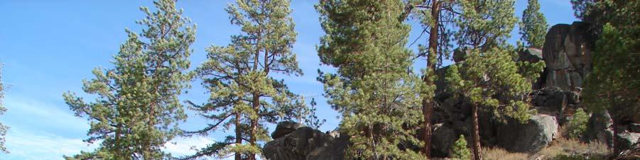
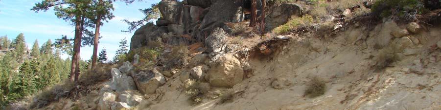
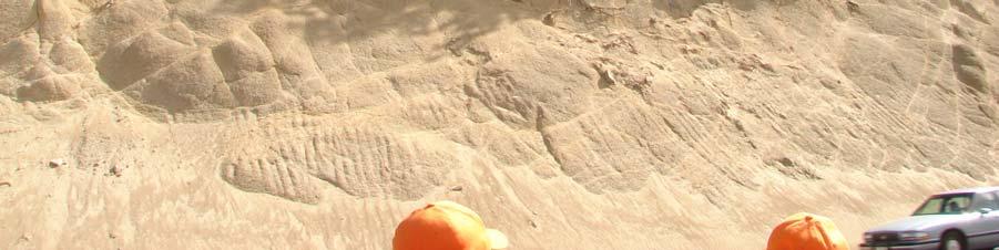
3 Project Overview The project consists of scaling loose rocks from a single slope above the roadway on US 50. Anchoring rocks or using rockfall meshes and fences are not being considered at this time. All scaled rocks and debris are to be removed from the project site. NDOT Maintenance forces will clean the bottom of the slope to remove any existing debris prior to work. Payment quantities are expected to be for scaled rock only and in-place soil on the slope should remain on the slope during the scaling process. Scaling work is to be done in a manner that keeps future erosion on the slope to a minimum. The slope is to be scaled prior to an overlay project planned to start in the spring or summer of The scaling project is planned to take approximately two weeks to scale plus one week to mobilize equipment and personnel to the site. The Rockfall Hazard Rating System (RHRS) study and report prepared by the University of Nevada (1993) identified this slope as Slope Number 13. This slope received a score of 305 and was the seventh from the top on the list of 62 slopes rated and ranked by Overall Detailed Rating Scores, where the slope at the top of the list has the greatest rockfall hazard potential. The slope is approximately forty feet high at its peak, consisting of granodiorite bedrock having a geologic character that is mainly erosional. The two factors that contributed the most to the RHRS score were the Average Vehicle Risk (based on the slope length and traffic speed limit) and Site Distance (based on reduced visibility due to the existence of a horizontal curve of the road at this location). The report recommends mitigating the slope by scaling mostly on the top and ends of the slope. The majority of the scaling work to be accomplished is at the crest of the slope where a soil cover layer has been exposed due to construction of the cut slope. This can be seen in the photos in this report. There are many rocks within the soil cover layer that are eroding out of the bedrock below the soil cover layer. Most of the slope face below this soil cover layer is bedrock and does not need scaling. 1
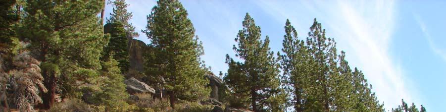
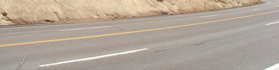
4 Site Location The slope is located just south of Logan Creek Drive on US 50 near Lake Tahoe. It is located from milepost DO 8.47 to DO 8.61 in Douglas County, Nevada on the east side of the road. The road at this location has four lanes, two northbound and two southbound. A pullout area exists on the west side of the road for about one-third of the slope length, directly across from the center of the slope. Recommendations Photos 4 through 8 show areas with circles around groups of rocks recommended for scaling. Some rocks that are circled in the photos may stay in place if determined during scaling attempts that they are firmly attached to bedrock. Other rocks on the slope that are not circled might need scaling, which have to be determined during construction and approved by the NDOT Engineer prior to scaling. There is a house that was built on top of rocks on the backside of the hill that may be impacted if the large rocks on the top of the hill above the slope are excessively disturbed. Caution must be exercised to not disturb the large rocks on top of the hill above the crest of the slope. Rocks scaled from the slope might possibly travel across the road and down the slope on the west side of the road. Several houses are located directly below the highway that could potentially be damaged if a rock were to travel over the road, down the west side and impact the house. A temporary moveable barrier must be placed on or at the edge of the roadway to control moving rocks. The moveable barrier must be of sufficient height and strength to capture nearly all material coming off the slope. Typical barriers used for roadway are not adequate for this application. Placing the moveable barrier in the center of the road would allow for quick cleanup of material from the road on the south bound side after scaling. Stopping traffic will only be allowed for a limited period of time, as specified in the Special Provisions for this project. The barrier allows traffic to continue quickly by keeping rocks off of the south bound travel lanes. 2
5 Rock splitting techniques should be expected for use, however no blasting, noticeably loud techniques or techniques that cause rocks to be thrown in the air are allowed. All methods of work shall be reviewed and accepted by the Engineer prior to use. The approximate volume of material expected to be generated by scaling is 400 cubic yards. The work will require specialized equipment and manpower including scalers in harnesses hanging from ropes attached to the top of the slope face (repelling), use of a man lift bucket to allow scalers to reach the slope face or other means that can place scalers directly on the slope face. Scaling may be performed by using hand tools such as power tools (hydraulic or other types of rock splitters approved by the Engineer, jackhammers, etc.), pulling cables, crowbars, prybars, jacks and shovels. Excavation using heavy equipment may be used, only if necessary, for slope sections where removing rocks, such as a boulder or overhanging bedrock outcrop, using hand scaling is not practical. Scraping the slope face or dragging heavy objects on the slope face is not allowed. Slope scaling should start at the top of the slope and proceed down slope while removing rocks. All material on the slope face that is loose, hanging or creating a dangerous condition will need to be removed or stabilized during or after completion of that section of slope. References 1. Application of the rockfall Hazard Rating System To the Rock Slopes Adjacent to US 50 and State Route 28 On the East Side of Lake Tahoe, Nevada (November 18, 1993), by Robert Flatland, Advisor Robert J. Watters, University of Nevada, Reno. 2. Rockfall Hazard Rating System Participant Manual, Publication No. FHWA SA , November 1993, National Highway Institute. 3


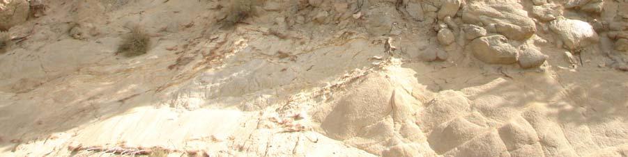
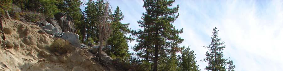
6 Photos 1 and 2. US 50 slope just south of Logan Creek Drive. 4


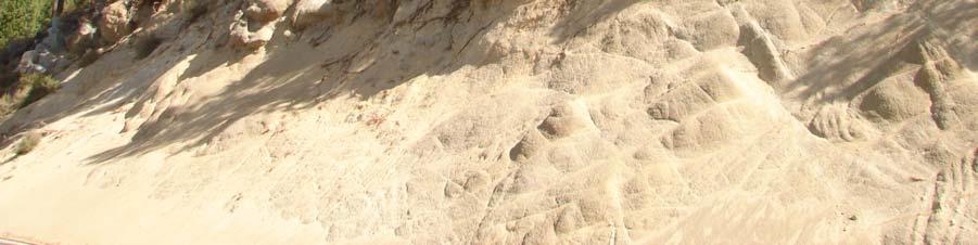
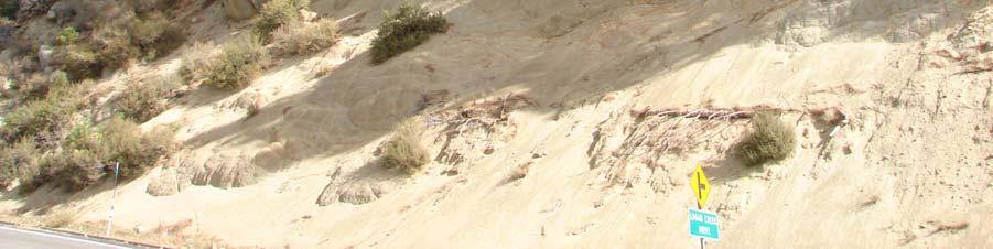
7 Photos 3 and 4. North end of slope showing recommended rocks to be removed. 5


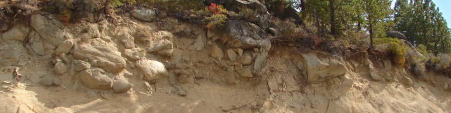
8 Photos 5 and 6. Center of slope showing recommended rocks to be removed. 6


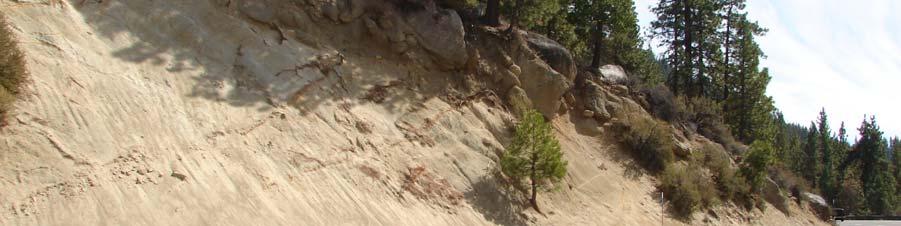
9 Photos 7 and 8. South end of slope showing recommended rocks to be removed. 7
3.12 Geology and Topography Affected Environment
 3 Affected Environment and Environmental Consequences 3.12 Geology and Topography 3.12.1 Affected Environment 3.12.1.1 Earthquakes Sterling Highway MP 45 60 Project Draft SEIS The Kenai Peninsula is predisposed
SEISMIC REFRACTION SURVEY RIPPABILITY STUDY
 SEISMIC REFRACTION SURVEY RIPPABILITY STUDY US 95A SILVER SPRINGS to FERNLEY LYON COUNTY August 2008 E.A. 73455 MATERIALS DIVISION SEISMIC REFRACTION SURVEY RIPPABILITY STUDY LYON COUNTY US 95A SILVER
August 10, 2007 File:
 August 10, 2007 File: 15-85-72 Alberta Infrastructure and Transportation Room 301, Provincial Building 9621-96 Avenue Peace River, AB T8S 1T4 Attention: Mr. Ed Szmata PEACE REGION (PEACE HIGH LEVEL AREA)
Construction Exits Vibration grids
 Construction Exits Vibration grids SEDIMENT CONTROL TECHNIQUE Type 1 System Sheet Flow Sandy Soils Type 2 System Concentrated Flow Clayey Soils [1] Type 3 System Supplementary Trap Dispersive Soils [1]
U-Shaped Sediment Traps
 U-Shaped Sediment Traps SEDIMENT CONTROL TECHNIQUE Type 1 System Sheet Flow Sandy Soils Type 2 System Concentrated Flow Clayey Soils [1] Type 3 System Supplementary Trap Dispersive Soils [1] Generally
Resolution Number: (2) Resolution Title: Snow Policy Date Signed: 11/26/12. DAVIS COUNTY Snow Policy Resolution
 Resolution Title: Snow Policy Date Signed: 11/26/12. DAVIS COUNTY Snow Policy Resolution") Resolution Number: 112612(2) Resolution Title: Snow Policy Signed: 11/26/12 DAVIS COUNTY Snow Policy Resolution A RESOLUTION TO ESTABLISH THE POLICY AND LEVEL OF SERVICE IN RESPECT TO CLEARANCE OF SNOW
Resolution Number: 112612(2) Resolution Title: Snow Policy Signed: 11/26/12 DAVIS COUNTY Snow Policy Resolution A RESOLUTION TO ESTABLISH THE POLICY AND LEVEL OF SERVICE IN RESPECT TO CLEARANCE OF SNOW
US82 ROCKFALL MITIGATION PROJECT May, BY Mohammed Ghweir Engineering Geologist Geotechnical Design Section New Mexico DOT
 US82 ROCKFALL MITIGATION PROJECT May, 2009 BY Mohammed Ghweir Engineering Geologist Geotechnical Design Section New Mexico DOT SACRAMENTO MTS Rock Fall Signs Back Ground US82 Connects the Town of Alamogordo,
Rock & Aggregate Drop Inlet Protection
 Rock & Aggregate Drop Inlet Protection SEDIMENT CONTROL TECHNIQUE Type 1 System Sheet Flow Sandy Soils Type 2 System [1] Concentrated Flow Clayey Soils Type 3 System Supplementary Trap Dispersive Soils
B805 TEMPORARY EROSION AND SEDIMENT CONTROL MEASURES - OPSS 805
 B805 MEASURES - OPSS 805 805.1 GENERAL Construction activities frequently remove protective cover and expose soil to accelerated rates of erosion. Sediments generated thereby can be conveyed via runoff
Construction Exits Rock pads
 Construction Exits Rock pads SEDIMENT CONTROL TECHNIQUE Type 1 System Sheet Flow Sandy Soils Type 2 System Concentrated Flow [1] Clayey Soils Type 3 System Supplementary Trap Dispersive Soils [1] Minor
Dust Storms in Arizona: The Challenge to Ensure Motorist Safety Jennifer Toth, P.E. Deputy Director for Transportation
 Dust Storms in Arizona: The Challenge to Ensure Motorist Safety Jennifer Toth, P.E. Deputy Director for Transportation Arizona Department of Transportation AASHTO Extreme Weather Event Symposium May 21,
Materials. Use materials meeting the following.
 208.01 Section 208. SOIL EROSION AND SEDIMENTATION CONTROL 208.01 Description. Install and maintain erosion and sedimentation controls to minimize soil erosion and to control sedimentation from affecting
IOWA COUNTY ORDINANCE NO. 22 IOWA COUNTY SNOW & ICE POLICY
 IOWA COUNTY ORDINANCE NO. 22 IOWA COUNTY SNOW & ICE POLICY AN ORDINANCE REPEALING ESTABLISHING THE POLICY AND LEVEL OF SERVICE IN RESPECT TO CLEARANCE OF SNOW AND ICE AND MAINTENANCE OF IOWA COUNTY S SECONDARY
DELAWARE COUNTY ORDINANCE NO. 3
 DELAWARE COUNTY ORDINANCE NO. 3 AN ORDINANCE TO ESTABLISH THE POLICY AND LEVEL OF SERVICE IN RESPECT TO CLEARANCE OF SNOW OR ICE AND MAINTENANCE OF THIS COUNTY'S SECONDARY ROADS DURING THE WINTER MONTHS.
Geotechnical Risks and Slope Management Systems: An FHWA Perspective
 August 20, 2010 10 th Annual Technical Forum Geohazards Impacting Transportation in the Appalachian Region Geotechnical Risks and Slope Management Systems: An FHWA Perspective Silas C. Nichols, PE, Senior
Geotechnical Risks and Management Systems: An FHWA Perspective
 October 13, 2010 2010 STGE Conference Charleston, WV Geotechnical Risks and Management Systems: An FHWA Perspective Silas C. Nichols, PE, Senior Bridge Engineer - Geotechnical Federal Highway Administration
Oktoberforum 2005: Case Histories in Engineering Geology and Geotechnical Engineering,, 4 th Oct. 2005, Petaling Jaya
 IEM-GSM Oktoberforum 2005: Case Histories in Engineering Geology and Geotechnical Engineering,, 4 th Oct. 2005, Petaling Jaya DISCONTINUITIES STUDY AND ROCK SLOPES STABILITY ANALYSIS FOR ROCK MASS AT DAMANSARA
Coarse Sediment Traps
 Coarse Sediment Traps SEDIMENT CONTROL TECHNIQUE Type 1 System Sheet Flow Sandy Soils Type 2 System [1] Concentrated Flow Clayey Soils [2] Type 3 System Supplementary Trap Dispersive Soils [1] Though primarily
Early Exploration Permit Activity Information
 Early Exploration Permit Activity Information Activities That Require an Early Exploration Permit: Line cutting that is a width greater than 1.5 metres Mechanized stripping of a total surface area of greater
CEDAR COUNTY ORDINANCE NO. 6
 CEDAR COUNTY ORDINANCE NO. 6 AN ORDINANCE TO ESTABLISH THE POLICY AND LEVEL OF SERVICE IN RESPECT TO CLEARANCE OF SNOW OR ICE AND MAINTENANCE OF THIS COUNTY'S SECONDARY ROADS DURING THE WINTER MONTHS.
Canadian Consulting Engineering Awards 2017 Southern Alberta Rock Slope Stabilization & Other Work Amec Foster Wheeler
 Southern Alberta Rock Slope Stabilization & Other Work Amec Foster Wheeler To: Mr. Doug Picklyk Editor, Canadian Consulting Engineer magazine Date April 20, 2017 From: Chelsea Johnson, P.Eng. Amec Foster
January 16, Re: Soo Line Dump Site 2018 Annual Soil Cover Inspection. Dear Mr. Nichols:
 January 16, 2019 Mr. Andrew Nichols Minnesota Pollution Control Agency Voluntary Investigation and Cleanup Program 520 Lafayette Road Saint Paul, Minnesota 55155 Re: Soo Line Dump Site 2018 Annual Soil
 265 Dalewood Way alteration permit #2016/02/17/9761 June 30, 2016 Appeal #16-109 Deck at Rear due to conflict with Slope Protection Act A. Executive Summary: We are in receipt of the Notification of Structural
POTENTIAL USE OF GROUND PENETRATING RADAR IN HIGHWAY ROCK CUT STABILITY Norbert H. Maerz* and Wooyoung Kim^ ABSTRACT INTRODUCTION
 Geophysics 2000, Dec. 11-15, 2000, St. Louis, MO, 9 pp. POTENTIAL USE OF GROUND PENETRATING RADAR IN HIGHWAY ROCK CUT STABILITY Norbert H. Maerz* and Wooyoung Kim^ *Rock Mechanics and Explosives Research
1. Major streets, Central Business District (CBD) and school bus routes. 2. Local streets 3. Downtown parking lots
 and school bus routes. 2. Local streets 3. Downtown parking lots") City of Mt. Pleasant Administrative Memo #1-85 Issued: January 1, 1985 SUBJECT: Snow and Ice Control Policy SUMMARY: The intent of this policy is to construct a basic guideline to effectively and efficiently
City of Mt. Pleasant Administrative Memo #1-85 Issued: January 1, 1985 SUBJECT: Snow and Ice Control Policy SUMMARY: The intent of this policy is to construct a basic guideline to effectively and efficiently
CHAPTER FIVE 5.0 STABILITY OF CUT SLOPES IN THE STUDY AREA. them limited by a thick canopy of vegetation and steep slope angles.
 CHAPTER FIVE 5.0 STABILITY OF CUT SLOPES IN THE STUDY AREA 5.1. Introduction Ukay Perdana area is a developing community with continuous building activities and road construction. There are thus only left
Wells Truck Climbing Lane Elko County
 Wells Truck Climbing Lane Elko County August 23, 2018 STATE OF NEVADA DEPARTMENT OF TRANSPORTATION MATERIALS DIVISION GEOTECHNICAL SECTION GEOTECHNICAL REPORT WELLS TRUCK CLIMBING LANE ELKO COUNTY August
COUNCIL POLICY MANUAL
 COUNCIL POLICY MANUAL SECTION: PUBLIC WORKS SUBJECT: SNOW & ICE CONTROL POLICY 2012/2013 GOAL: Pages: 1 of 10 Approval Date: Dec. 3, 2012 Res. # 1001/2012 To annually identify the winter maintenance costs
3.12 Geology and Topography Affected Environment
 3 Affected Environment and Environmental Consequences 3.12 Geology and Topography 3.12.1 Affected Environment 3.12.1.1 Earthquakes Sterling Highway MP 45 60 Project Final EIS The Kenai Peninsula is predisposed
PENNSYLVANIA DEPARTMENT OF TRANSPORTATION ENGINEERING DISTRICT 3-0
 PENNSYLVANIA DEPARTMENT OF TRANSPORTATION ENGINEERING DISTRICT 3-0 LYCOMING COUNTY S.R.15, SECTION C41 FINAL HYDROLOGIC AND HYDRAULIC REPORT STEAM VALLEY RUN STREAM RELOCATION DATE: June, 2006 REVISED:
Preliminary Geotechnical Review, Angels Crest Rock Fall, Stawamus Chief, Squamish, BC
 GeoPacific #215 1200 West 73 rd Avenue, Vancouver, BC, V6P 6G5 Consultants Ltd. Phone (604) 439-0922 / Fax (604) 439-9189 District of Squamish May 5, 2015 37955 Second Avenue File: 12942 P.O. Box 310 V8B
General. High Winds. High winds are a common hazard in the UAE.
 General guidance for employers and workers in inclement weather conditions Date: March 2017 OSHAD 2017 This document is and shall remain the property of OSHAD. The document may only be used for the purposes
SNOW REMOVAL POLICY ITASCA COUNTY TRANSPORTATION DEPARTMENT
 ITASCA COUNTY TRANSPORTATION DEPARTMENT Effective Date: November 1, 1989 Revised: November 18, 2014 Policy Number: Operations 89-4 Distribution: Commissioner's Office Engineer's Office All Garages Number
February 18, 2003 File: NORTH CENTRAL REGION LANDSLIDE ASSESSMENT HWY 43:16 WHITECOURT EAST HILL (NC1) 2002 ANNUAL INSPECTION REPORT
 2002 ANNUAL INSPECTION REPORT") February 18, 2003 File: 15-76-11 Alberta Transportation Room 223, Provincial Building 4709 44 Avenue Stony Plain, Alberta T7Z 1N4 Attention: Mr. Rob Lonson, P.Eng. NORTH CENTRAL REGION LANDSLIDE ASSESSMENT
February 18, 2003 File: 15-76-11 Alberta Transportation Room 223, Provincial Building 4709 44 Avenue Stony Plain, Alberta T7Z 1N4 Attention: Mr. Rob Lonson, P.Eng. NORTH CENTRAL REGION LANDSLIDE ASSESSMENT
Dunn County Snow Removal Policy
 Dunn County Snow Removal Policy OVERVIEW With the advent of another winter season in the northern plains comes the possibility of snow, freezing rain and slippery roadways, and area resident s concern
GOAL 7 AREAS SUBJECT TO NATURAL DISASTERS AND HAZARDS. To protect life and property from natural disasters and hazards.
 GOAL 7 AREAS SUBJECT TO NATURAL DISASTERS AND HAZARDS A. GOALS: To protect life and property from natural disasters and hazards. B. POLICIES: 1. Floodplains shall be maintained as natural drainage-ways.
The last three sections of the main body of this report consist of:
 Threatened and Endangered Species Geological Hazards Floodplains Cultural Resources Hazardous Materials A Cost Analysis section that provides comparative conceptual-level costs follows the Environmental
DRAFT. PRELIMINARY LANDSLIDE MODELING for KRAMER AVENUE LANDSLIDE SITKA, ALASKA. Prepared for: Andrew Friske 210 Kramer Ave. Sitka, Alaska 99835
 PRELIMINARY LANDSLIDE MODELING for KRAMER AVENUE LANDSLIDE SITKA, ALASKA Prepared for: Andrew Friske 210 Kramer Ave. Sitka, Alaska 99835 Prepared by: Northern Geotechnical Engineering, Inc. d.b.a. Terra
Field Trip Workbook G200 Field Studies Sec 001 (Mt St. Helens north) Fall, 2018 Professor in charge: Alex Ruzicka TA : Secana Goudy
 Fall, 2018 Professor in charge: Alex Ruzicka TA : Secana Goudy") Field Trip Workbook NAME: G200 Field Studies Sec 001 (Mt St. Helens north) Fall, 2018 Professor in charge: Alex Ruzicka TA : Secana Goudy Use this workbook to answer the following questions about the geology
Field Trip Workbook NAME: G200 Field Studies Sec 001 (Mt St. Helens north) Fall, 2018 Professor in charge: Alex Ruzicka TA : Secana Goudy Use this workbook to answer the following questions about the geology
3/8/17. #20 - Landslides: Mitigation and Case Histories. Questions for Thought. Questions for Thought
 #20 - Landslides: Mitigation and Case Histories Web Exercise #3 (Volcanoes) Due Wednesday There is a 2-point penalty for every day the assignment is late. Exam 1 Scores Scores and exam key are posted Vaiont
Town of Windsor. Department of Public Works
 Town of Windsor Department of Public Works 860.285.1855 TOWN OF WINDSOR PUBLIC WORKS SNOW REMOVAL PLAN In Windsor, as throughout the New England states, winter can bring a variety of weather conditions
City of Camrose Winter Road Maintenance Policy
 City of Camrose Winter Road Maintenance Policy The purpose of this policy is to outline the level of service that the City of Camrose delivers regarding the maintenance of roads in winter conditions. 1.
ADDENDA #1 CONTRACT # C May 3, 2013 Page 1 of 1
 State of California Natural Resources Agency Edmund G. Brown Jr., Governor DEPARTMENT OF PARKS AND RECREATION Major General Anthony L. Jackson, USMC (Ret), Director ADDENDA #1 CONTRACT # C1247040 May 3,
CUSTER COUNTY SNOW REMOVAL PROCEDURES
 CUSER COUNY SNOW REMOVAL PROCEDURES Prioritization of Plow Routes County-maintained roads are plowed based upon the following prioritization criteria: 1. Arterial Roadways and School Bus routes: Arterial
Snow Removal Policy WARREN COUNTY ENGINEER S OFFICE (WCEO) WARREN COUNTY HIGHWAY DEPARTMENT. October 16, 2014
 WARREN COUNTY HIGHWAY DEPARTMENT. October 16, 2014") Snow Removal Policy WARREN COUNTY ENGINEER S OFFICE (WCEO) October 16, 2014 Presented by: Neil F. Tunison, Warren County Engineer Snow Removal Policy OPERATIONS SAFETY WARREN COUNTY ENGINEER S OFFICE (WCEO)
Snow Removal Policy WARREN COUNTY ENGINEER S OFFICE (WCEO) October 16, 2014 Presented by: Neil F. Tunison, Warren County Engineer Snow Removal Policy OPERATIONS SAFETY WARREN COUNTY ENGINEER S OFFICE (WCEO)
Physics 1A, Summer 2011, Summer Session 1 Quiz 3, Version A 1
 Physics 1A, Summer 2011, Summer Session 1 Quiz 3, Version A 1 Closed book and closed notes. No work needs to be shown. 1. Three rocks are thrown with identical speeds from the top of the same building.
Project (Project No. US-CA-62-2) Maintenance Inspection and Reports (Subtask 14.1) Inspection Report No.2
 Maintenance Inspection and Reports (Subtask 14.1) Inspection Report No.2") MEMORANDUM TO: FROM: Jim Well, Ducks Unlimited Mike Harvey, PhD, PG SUBJECT: M&T/ Llano Seco Fish Screen Project (Project No. US-CA-62-2) Maintenance Inspection and Reports (Subtask 14.1) Inspection Report
MEMORANDUM TO: FROM: Jim Well, Ducks Unlimited Mike Harvey, PhD, PG SUBJECT: M&T/ Llano Seco Fish Screen Project (Project No. US-CA-62-2) Maintenance Inspection and Reports (Subtask 14.1) Inspection Report
APPENDIX IV MODELLING
 APPENDIX IV MODELLING Kingston Transportation Master Plan Final Report, July 2004 Appendix IV: Modelling i TABLE OF CONTENTS Page 1.0 INTRODUCTION... 1 2.0 OBJECTIVE... 1 3.0 URBAN TRANSPORTATION MODELLING
2. Initial Summary of Preliminary Expert Opinion of Converse and Psomas Reports
 UNITED WALNUT TAXPAYERS PRELIMINARY REVIEW OF NEGATIVE GEOTECHNICAL AND GEOLOGICAL ASPECTS OF CONSTRUCTING EARTHFILL PAD FOR A SOLAR FARM ON THE WEST PARCEL - DRAFT 1. Introduction A licensed Engineering
Snow and Ice Control POLICY NO. P-01/2015. CITY OF AIRDRIE Snow and Ice Control Policy
 Page 1 CITY OF AIRDRIE Snow and Ice Control Effective Date: Approved By: Approved On: March 17, 2015 City Council March 16, 2015 Revision Date: Resolution #: ------ PURPOSE: The City of Airdrie is responsible
BOONE COUNTY Snow Removal Program and Policy SECTION 1, INTRODUCTION:
 BOONE COUNTY Snow Removal Program and Policy SECTION 1, INTRODUCTION: The Roads Department of Boone County is responsible for providing snow removal for approximately 1100 miles of county roads. The Roads
1. PROJECT BACKGROUND. July 18, Alberta Infrastructure & Transportation Central Region #401, Street Red Deer, Alberta T4N 6K8
 July 18, 2005 Alberta Infrastructure & Transportation Central Region #401, 4902 51 Street Red Deer, Alberta T4N 6K8 Mr. Alain Momedi, P.Eng. Project Engineer Dear Mr. Momedi: H11:04 km 11.1 Erosion along
H IG HWAY WINTER OPERATIONS SNOW REMOVAL AND ICE CONTROL POLICY. Revised January 4, 2016
 ! H IG HWAY WINTER OPERATIONS SNOW REMOVAL AND ICE CONTROL POLICY Adopted January 11, 2010 Revised January 4, 2016 Pol icy It is the goal and intent of the Town of Sullivan to provide timely, efficient
INSTALLATION INSTRUCTIONS ATV Plow Blade Part Number: (50 ), (54 ), or (60 ) Application: All Terrain Vehicles
, (54 ), or (60 ) Application: All Terrain Vehicles") INSTALLATION INSTRUCTIONS ATV Plow Blade Part Number: 78950 (50 ), 78954 (54 ), or 78960 (60 ) Application: All Terrain Vehicles Your safety, and the safety of others, is very important. To help you make
INSTALLATION INSTRUCTIONS ATV Plow Blade Part Number: 78950 (50 ), 78954 (54 ), or 78960 (60 ) Application: All Terrain Vehicles Your safety, and the safety of others, is very important. To help you make
ROCK EXCAVATION (GRADING) OPSS 206 INDEX
 OPSS 206 INDEX") 206-2 - OPSS 206 INDEX 206-2.1 GENERAL 206-2.1.1 Classification of Rock Materials 206-2.1.2 Tender Items 206-2.1.3 Other Excavation Tender Items 206-2.1.4 Specifications 206-2.1.5 Special Provisions 206-2.1.6
206-2 - OPSS 206 INDEX 206-2.1 GENERAL 206-2.1.1 Classification of Rock Materials 206-2.1.2 Tender Items 206-2.1.3 Other Excavation Tender Items 206-2.1.4 Specifications 206-2.1.5 Special Provisions 206-2.1.6
Woodford County Erosion Prevention Plan and Permit. Application #
 Woodford County Erosion Prevention Plan and Permit Application # Date Instructions: Applicant will complete Parts A and B, and attach a proposed site diagram. This diagram must be completed in accordance
TRAFFIC ALERT FOR WEEK OF February 4 8, 2008
 TRAFFIC ALERT FOR WEEK OF February 4 8, 2008 Highway work zones in the Staunton District The following is a list of highway work that might affect traffic in the Staunton transportation district during
1 PROJECT BACKGROUND. August 14, Alberta Transportation Central Region #401, Street Red Deer, Alberta T4N 6K8
 August 14, 2013 Alberta Transportation Central Region #401, 4902 51 Street Red Deer, Alberta T4N 6K8 Mr. Dennis Grace, P.Eng. Construction Engineer Dear Mr. Grace: Central Region Geohazard Assessment 2013
AASHTO Extreme Weather Events Symposium Vermont s Road and Rivers - Managing for the Future
 AASHTO Extreme Weather Events Symposium Vermont s Road and Rivers - Managing for the Future May 22, 2013 PLANET EARTH 2 2 MANY MANYYEARS AGO 23,000 years ago there was more than 8,000 feet of glacier over
SNOWPLOWING/ICE CONTROL POLICY
 SNOWPLOWING/ICE CONTROL POLICY BACKGROUND: The Town of White Bear, Minnesota, finds that in the best interest of the residents of the Town to assume basic responsibility for the control of snow and ice
Town of Oconomowoc Snow & Ice Control Policy
 Town of Oconomowoc Snow & Ice Control Policy Introduction The purpose of this policy is to provide a detailed overview of the Town s snow & ice control operations including its goals and objectives. All
 TYPE YEAR PROJECT NO. SHEET NO. 4-203.02 D. TRANS ITIONAL MATERIALS TENNESSEE D.O.T. DESIGN DIVISION FILE NO. REPRESENTATIVE OF STATION 14+75 TO STATION 19+00 THIS MATERIAL IS THAT MATERIAL COMPRISED OF
FOR PROJECTS INITIATED AFTER NOVEMBER 1, 2008 ITEM 716 EMBANKMENT EARTH OUTLET SEDIMENT TRAP
 AFTER NOVEMBER 1, 2008 ITEM 716 EMBANKMENT EARTH OUTLET SEDIMENT TRAP 716.1 Description. This work shall consist of furnishing, installing, maintaining, and removing temporary erosion protection and sediment
Active Traffic & Safety Management System for Interstate 77 in Virginia. Chris McDonald, PE VDOT Southwest Regional Operations Director
 Active Traffic & Safety Management System for Interstate 77 in Virginia Chris McDonald, PE VDOT Southwest Regional Operations Director Interstate 77 at Fancy Gap Mountain Mile markers 0-15 Built in late
Minnesota Local Road Research Board Local Operational Research Assistance Program (OPERA)
") Minnesota Local Road Research Board Local Operational Research Assistance Program (OPERA) June 18, 2012 Evaluation of De-Icing and Anti-Icing Technologies OPERA Project Number: 2010-2 Project Sponsor:
Minnesota Local Road Research Board Local Operational Research Assistance Program (OPERA) June 18, 2012 Evaluation of De-Icing and Anti-Icing Technologies OPERA Project Number: 2010-2 Project Sponsor:
Prepared for: U.S. Army Corps of Engineers, Mobile District 109 St. Joseph Street, Mobile, Alabama Prepared by:
 Final Site-Specific Unexploded Ordnance Safety Plan Attachment Site Investigation at Artillery and Mortar Impact Areas South of Bains Gap Road, Parcels 138Q-X, 139Q-X, 140Q-X, 141Q-X, and 142Q-X Fort McClellan,
Wyoming State Operations Center
 Wyoming State Operations Center Updated Situation Report, Bordeaux Tornado site 14: 36 hrs 8 June 2012 Wyoming Office of Homeland Security (WOHS) arrived at the incident command post at the corner of Olson
CITY OF EAST PEORIA SNOW AND ICE CONTROL PROGRAM INTRODUCTION
 CITY OF EAST PEORIA SNOW AND ICE CONTROL PROGRAM INTRODUCTION The responsibility for providing snow and ice control on East Peoria s 240 lane miles of streets and alleys rests with the Street Divisions
The Sunland Park flyover ramp is set to close the week of March 19 until early summer
 March 2, 2018 The Sunland Park flyover ramp is set to close the week of March 19 until early summer GO 10 is targeting the week of March 19 to close the Sunland Park Drive flyover entrance ramp to I 10
POLICY MANUAL. Hamlets/Residential named hamlets within the County of Grande Prairie whose roads are hard surfaced.
 POLICY MANUAL Legal References: Policy department: Public Works Department Cross References: N7 Adoption Date: January 19, 2005 Revision Date: June 20, 2005 Motion# 06/662/2005 October 20, 2014 Motion#
MANUAL FOR ROCKFALL INVENTORY PREPARED BY:
 MANUAL FOR ROCKFALL INVENTORY PREPARED BY: THE OHIO DEPARTMENT OF TRANSPORTATION OFFICE OF GEOTECHNICAL ENGINEERING 1980 WEST BROAD STREET COLUMBUS, OHIO 43223 DECEMBER 2016 TABLE OF CONTENTS SECTION 100
Tornadoes. Be able to define what a tornado is. Be able to list several facts about tornadoes.
 Tornadoes Be able to define what a tornado is. Be able to list several facts about tornadoes. 1. Where do tornadoes most U.S. is # 1 occur in the world? Tornadoes are most common in Tornado Alley. Tornado
October 26, Ms. Aimee Zack Canadian Pacific 120 S. Sixth Street Suite 900 Minneapolis, Minnesota 55402
 October 26, 2017 Ms. Aimee Zack Canadian Pacific 120 S. Sixth Street Suite 900 Minneapolis, Minnesota 55402 Re: Soo Line Dump Site 2017 Annual Soil Cover Inspection Dear Aimee: The purpose of this letter
Advanced Geologic Exploration, Inc.
 Advanced Geologic Exploration, Inc. Scientists of the Earth PO Box 1956, Chester, CA 96020 Voice: (530) 258-4228 Fax (530) 258-4339 www.advancedgeologic.com January 23, 2009 Job No. G-081201 Terri Barber,
OREGON DEPARTMENT OF TRANSPORTATION STATEWIDE ROAD, WEATHER AND INCIDENT CONDITIONS 4/22/2019 4:20:05 AM
 OREGON DEPARTMENT OF TRANSPORTATION STATEWIDE ROAD, WEATHER AND INCIDENT CONDITIONS Incidents/: 4/22/2019 4:20:05 AM HWY372 22 22 Mount Bachelor Ski Area I-5 10 13 5 Mi S of Ashland Informational only
ENGINEERING EVALUATION OF THE STANLEY MINE ADVENTURE PARK AREA CLEAR CREEK COUNTY, COLORADO. Prepared for:
 braun Braun Consulting Engineers ENGINEERING EVALUATION OF THE STANLEY MINE ADVENTURE PARK AREA CLEAR CREEK COUNTY, COLORADO Prepared for: STANLEY MINES ADENTURE PARK 3375 W. POWERS CIRCLE LITTLETON, COLORADO
[1] Performance of the sediment trap depends on the type of outlet structure and the settling pond surface area.
![[1] Performance of the sediment trap depends on the type of outlet structure and the settling pond surface area.](/thumbs/76/74245181.jpg "[1] Performance of the sediment trap depends on the type of outlet structure and the settling pond surface area.") Sediment Trench SEDIMENT CONTROL TECHNIQUE Type 1 System Sheet Flow Sandy Soils Type 2 System [1] Concentrated Flow Clayey Soils Type 3 System [1] Supplementary Trap Dispersive Soils [1] Performance of
Sediment Trench SEDIMENT CONTROL TECHNIQUE Type 1 System Sheet Flow Sandy Soils Type 2 System [1] Concentrated Flow Clayey Soils Type 3 System [1] Supplementary Trap Dispersive Soils [1] Performance of
April 10, Mr. Curt Van De Walle, City Manager City of Castle Hills 209 Lemonwood Drive Castle Hills, Texas 78213
 Mr. Curt Van De Walle, City Manager City of Castle Hills 209 Lemonwood Drive Castle Hills, Texas 78213 Subject: Revised Castle Hills BASIS Charter School Traffic Impact Analysis Review City of Castle Hills,
WORK SESSION AGENDA COMMITTEE-OF-THE-WHOLE APRIL 1, 2019 CITY COUNCIL CHAMBERS IMMEDIATELY FOLLOWING THE COUNCIL MEETING
 WORK SESSION AGENDA COMMITTEE-OF-THE-WHOLE APRIL 1, 2019 CITY COUNCIL CHAMBERS IMMEDIATELY FOLLOWING THE COUNCIL MEETING 1. Snow Removal Procedures Steven Lang 2. 2020 Budget Streets & Highways Tom Dankert
STREUVER FIDELCO CAPPELLI, LLC YONKERS DOWNTOWN DEVELOPMENT PHASE 1. DRAFT ENVIRONMENTAL IMPACT STATEMENT For: PALISADES POINT
 STREUVER FIDELCO CAPPELLI, LLC YONKERS DOWNTOWN DEVELOPMENT PHASE 1 DRAFT ENVIRONMENTAL IMPACT STATEMENT For: PALISADES POINT Prepared by: PAULUS, SOKOLOWSKI & SARTOR STORMWATER MANAGEMENT 1. Methodology
AP Physics 1 Work Energy and Power Practice Test Name
 AP Physics 1 Work Energy and Power Practice Test Name MULTIPLE CHOICE. Choose the one alternative that best completes the statement or answers the question. 1) Two objects, one of mass m and the other
HISTORY OF CONSTRUCTION FOR EXISTING CCR SURFACE IMPOUNDMENT PLANT GASTON ASH POND 40 CFR (c)(1)(i) (xii)
(1)(i) (xii)") HISTORY OF CONSTRUCTION FOR EXISTING CCR SURFACE IMPOUNDMENT PLANT GASTON ASH POND 40 CFR 257.73(c)(1)(i) (xii) (i) Site Name and Ownership Information: Site Name: E.C. Gaston Steam Plant Site Location:
HISTORY OF CONSTRUCTION FOR EXISTING CCR SURFACE IMPOUNDMENT PLANT GASTON ASH POND 40 CFR 257.73(c)(1)(i) (xii) (i) Site Name and Ownership Information: Site Name: E.C. Gaston Steam Plant Site Location:
SLOPE STABILITY EVALUATION AND ACCEPTANCE STANDARDS
 INFORMATION BULLETIN / PUBLIC - BUILDING CODE REFERENCE NO.: LABC 7006.3, 7014.1 Effective: 01-01-2017 DOCUMENT NO.: P/BC 2017-049 Revised: 12-21-2016 Previously Issued As: P/BC 2014-049 SLOPE STABILITY
Chapter 5 THE DEVELOPMENT OF VOLCANIC EMERGENCY PLANS. 5.1 Introduction
 Chapter 5 THE DEVELOPMENT OF VOLCANIC EMERGENCY PLANS 5.1 Introduction It will be assumed in this chapter: (0) That in any community exposed to volcanic hazards there is general awareness of the hazard
Section 3. Slopes and Landscapes. What Do You See? Think About It. Investigate. Learning Outcomes
 Chapter 4 Surface Processes Section 3 Slopes and Landscapes What Do You See? Learning Outcomes In this section, you will Calculate the angle of repose for different kinds of soils and other granular materials.
Sediment Control Practices. John Mathews Ohio Dept. of Natural Resources, Division of Soil and Water Resources
 Sediment Control Practices John Mathews Ohio Dept. of Natural Resources, Division of Soil and Water Resources Practices Treat the Largest Soil Particles Sand Sand Silt Clay Treated Untreated Settleable
PW 001 SNOW REMOVAL AND SANDING FOR ROADWAYS AND SIDEWALKS October 6, 2014 (#223-14) Original October 19, 2015; October 15, 2018 Public Works
 Original October 19, 2015; October 15, 2018 Public Works") Policy Statement: The Village of Kitscoty will provide snow and ice control on municipal streets and sidewalks according to determined priorities. Purpose: To provide direction and information to employees
Policy Statement: The Village of Kitscoty will provide snow and ice control on municipal streets and sidewalks according to determined priorities. Purpose: To provide direction and information to employees
Mitigation of Gypsum Mine Voids Under SR-2 in Ottawa County, Ohio
 Subsurface Investigation and Conceptual Alternatives Mitigation of Gypsum Mine Voids Under SR-2 in Ottawa County, Ohio Presented By: Ohio Department of Transportation CH2M HILL CTL Engineering Technos,
Updating the Urban Boundary and Functional Classification of New Jersey Roadways using 2010 Census data
 Updating the Urban Boundary and Functional Classification of New Jersey Roadways using 2010 Census data By: Glenn Locke, GISP, PMP 1 GIS-T May, 2013 Presentation Overview Purpose of Project Methodology
Yoshinori KAWAMURA, Oriental Consultants Global Co., Ltd.
 Landslides along National Roads in Central Highland in Sri Lanka: Review on Current Situation and Suggestion for Further Development of Landslide Mitigation along Highways in Sri Lanka Yoshinori KAWAMURA,
Central Queensland Coal Project Appendix 4b Geotechnical Assessment. Environmental Impact Statement
 Central Queensland Coal Project Appendix 4b Geotechnical Assessment Environmental Impact Statement GEOTECHNICAL ASSESSMENT OF OPEN CUT MINING ADJACENT TO THE BRUCE HIGHWAY, CENTRAL QUEENSLAND COAL PROJECT
Tom Blackman Project Lead. Mékell Mikell Communications Representative
 Sediment Cleanup Middle River Complex, 2016-17 Season 1 Project Photo Tour Updated November 15, 2016 Tom Blackman Project Lead Mékell Mikell Communications Representative 1 Sediment Cleanup - Season 1
3.18 GEOLOGY AND SOILS
 3.18 GEOLOGY AND SOILS This section discusses geologic resource concerns as they relate to the environment, public safety, and project design both during construction and after completion of the project.
Landslide Mitigation (BYUI)
") Landslide Mitigation (BYUI) The general principle behind landslide mitigation is stabilization. Slopes that are too steep are shallowed or strengthened. Loose rocks can be bolted or cemented into place.
Landslide Mitigation (BYUI) The general principle behind landslide mitigation is stabilization. Slopes that are too steep are shallowed or strengthened. Loose rocks can be bolted or cemented into place.
CITY OF NEW LONDON WINTER ROAD & SIDEWALK MAINTENANCE POLICY
 CITY OF NEW LONDON WINTER ROAD & SIDEWALK MAINTENANCE POLICY GENERAL The purpose of this policy is to set up acceptable procedures and policies for the winter maintenance of public areas in the City of
CHAPTER GEOLOGICALLY HAZARDOUS AREAS Applicability Regulations.
 CHAPTER 19.07 GEOLOGICALLY HAZARDOUS AREAS 19.07.010 Applicability. Geologically hazardous areas may pose a threat to the health and safety of citizens when incompatible development is sited in areas of
Appendix M Preliminary Geotechnical Report, SR 32 Widening Project Study Report
 Appendix M Preliminary Geotechnical Report, SR 32 Widening Project Study Report November 3, 2005 Mr. Chris Rockway 7300 Folsom Boulevard, Suite 203 Sacramento, California 95826 Attention: Matt Brogan
Glacial Geology of Moose Point State Park, ME
 Geologic Site of the Month May, 2013 Glacial Geology of Moose Point State Park, Maine 44 o 25 59.18"N, 68 o 56 37.11"W Text and photos by Woodrow B. Thompson, Department of Agriculture, Conservation &
OXFORD HEIGHTS SUBDIVISION EMERGENCY EVACUATION PLAN
 OXFORD HEIGHTS SUBDIVISION EMERGENCY EVACUATION PLAN March 27, 2007 Oxford Heights Overview and Historical Conditions Oxford Heights is a medium sized community located on the southern side of Elizabeth
WEBER ROAD RESIDENTIAL DEVELOPMENT Single Family Residential Project
 WEBER ROAD RESIDENTIAL DEVELOPMENT Single Family Residential Project WEBER ROAD RESIDENTIAL DEVELOPMENT TRAFFIC IMPACT STUDY TABLE OF CONTENTS 1.0 Executive Summary Page 2.0 Introduction 2.1 DEVELOPMENT