Project Proposal. Lyme Brook. Newcastle-under-Lyme. 3 rd July 2015
|
|
|
- Madeline Taylor
- 5 years ago
- Views:
Transcription

1 Project Proposal Lyme Brook Newcastle-under-Lyme 3 rd July 2015
2 Contents Page 1.0 Introduction Background and rationale Proposed measures Summary of Recommendations Disclaimer Appendix
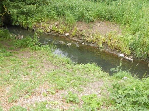
3 1.0 Introduction This report is the output of a site visit undertaken by Gareth Pedley of the Wild Trout Trust to Lyme Brook, Newcastle-under-Lyme. The visit was requested as a follow up to a previous visit undertaken by Dr Paul Gaskell of the Wild Trout Trust and the resulting practical project that was implemented at Lyme Valley Park and aims to extend the scope of that previous work. Normal convention is applied throughout the report with respect to bank identification, i.e. the banks are designated left bank (LB) or right bank (RB) whilst looking downstream. 2.0 Background and rationale As described in the previous report, Lyme Brook lies within an urbanised catchment where straightening and dredging have created a greatly simplified channel with a steepened gradient and a lack of natural substrate. Rock armouring of the banks in many places has prevented the Brook from eroding and naturally increasing its sinuosity, while also removing the Brook s natural mechanism for developing new bed material. The lack of erosion and scour also creates a channel that is greatly lacking in deeper pool features, and a bed comprised of oversized cobble and rubble on the steeper, narrower sections and fine silt and sand on the lower gradient, wider sections. There is also a general lack of in-channel structure (logs, fallen trees, and trailing branches) within many areas of the Brook, features that are required for both fish and invertebrates to thrive. Work resulting from the previous report, undertaken by Groundwork West Midlands and the Wild Trout Trust, has greatly improved habitat in the initial section. Upstream log deflectors have created enhanced flow diversity, increased depth and sinuosity (Fig. 1) and, in conjunction with introduced gravels (Figs. 1 & 2), now create potential spawning areas by providing the substrate that is missing from the realigned un-natural channel. The brash berms installed create valuable narrowing in wider sections, again, increasing flow diversity and velocity which will help to maintain the bed free from finer sediments, improving the quality of substrate for fish spawning and invertebrates (Fig 3). 3


4 Figure 1. Upstream flow deflectors increase flow diversity and the scour produced creates areas of deeper water. These deeper areas will be maintained by subsequent high flows. Also note the introduced gravels. Figure 2. Introduced gravels providing excellent potential fish spawning riffles. 4
 and the New Section (immediately downstream). 3.")
5 Figure 3. Brash berm, creating valuable narrowing, flow diversity and cover. 3.0 Proposed measures To capitalise on the work already undertaken, Groundwork would like to improve habitat in two further sections of the Brook. These are: The Extension Section (immediately upstream of the previous work) and the New Section (immediately downstream). 3.1 Extension Section (upstream of the original section) This section is very similar in character to the section already worked upon, being straight and of uniform depth, with relatively coarse substrate (Figs. 4 & 5). The areas are located immediately up and downstream of the footbridge at NGR: SJ It is proposed that an extension to the previous Flood Defence Consent be sought to undertake this work as it would only mean extending the upstream limit of the original works by a few hundred metres. Work would consist of installing upstream facing flow deflectors upstream of the bridge (Fig. 4), with the addition of gravel, if available. Downstream of the bridge, a brash berm and gravel could also be employed to accelerate flows for a short section (Fig. 5). 5
 flow deflectors (brown) would help to")
, a brash berm (brown and green hashed D")
6 Figure 4. Extension section (upstream of the bridge) flow deflectors (brown) would help to sort bed materials and diversify flows. Figure 5. Extension Section (downstream of the bridge), a brash berm (brown and green hashed D ) would be beneficial to accelerate flows under the RB canopy and trap fine sediment that can become vegetated. 6
7 3.2 New Section (downstream of the original section) (NGR : SJ SJ ) In the New section, the prescription is largely the same as in the upstream sections; however, as the channel is wider in many places, and the substrate is generally of a much finer nature (silt and sand), it is recommended to concentrate upon reinstating more natural channel dimensions (narrowing with berms and deflectors) before any gravel introductions are undertaken. Coarser substrate may then be revealed by natural scouring and sorting of the bed materials. In this section, it is also recommended that goat willow (Salix caprea - which will grow but stay small as they are a shrub species) and potentially other species (that will not grow) are installed as tree kickers (See Appendix 1). These are a very quick and easy way of pinching the channel to accelerate flows, while the structure in the river margin traps fine sediment. In some areas, the channel is already starting to recover with bed material accumulating in the river margins, often around existing structure (Fig. 6). These areas could easily be capitalised upon with the aforementioned techniques (berms, deflectors or kickers ) to further increase deposition in those areas and diversify the channel. Where the channel is already more sinuous, natural substrate berms (bars) are beginning to form, with a definite gradient from the shallow water on the inside of the bend, to deeper water on the outside (Fig. 7). These too could be improved by increasing the channel roughness in those areas to encourage additional deposition that will improve flows maintain the depth of the deeper channel to the outside of the bend. Pinned brash in the margin or a brash berm would work well, as would one medium tree kicker (which would be the quickest option to install. The impact of a channel with greater geomorphological diversity is already plain to see, with shoals of dace (Leuciscus leuciscus) present in those areas, taking advantage of the deeper water pool features (Fig. 8). Accelerating flows to clean and sort the substrate further, in discrete areas, will also benefit the dace, and other coarse fish, as they too require silt free gravels on which to spawn, albeit finer gravels than trout (Salmo trutta). 7


8 Figure 6. Natural deposition in the margin, probably around some rougher structure in the channel. This could be improved upon with further increased structure. Figure 7. Shallowing on the inside of the bend where sediment is beginning to accumulate and take up some of the excess channel capacity (red outline) and a deeper area beginning to form on the outside of the bend (blue arrow). 8
, for the installation of pre-agreed habitat improvements including")
9 Figure 8. A shoal of small dace, taking advantage of the deeper pool areas. It is recommended that a Flood Defence Consent is sought to cover the entirety of the New Section (SJ SJ ), for the installation of pre-agreed habitat improvements including brash berms, log deflectors and tree kickers. This will have to be done through liaison with the consenting officer, but as the techniques are all simple and low impact, and to be undertaken in a low flood risk area, this would be the most efficient way to reduce bureaucracy and maximise the ecological gains. As the consent will be valid for 3 years, it also allows the work to be done in stages, providing that the consenting officer is notified within a week of the work being undertaken. 9
10 4.0 Summary of Recommendations Extension Section Downstream Section Recommendations Seek an extension to the original Flood Defence Consent to install two flow deflectors and brash berms u/s and d/s of the footbridge, within 100m either side. Gravel introduction would also be beneficial around the structures, as in the original section. Seek a new Flood Defence Consent to install a number of flow deflectors, berms and tree kickers throughout the section. This may require a site visit with the consenting officer to assess the works already undertaken and discuss the exact scope of the work. Grid Reference SJ SJ SJ Refer to the previous report which should be submitted in conjunction with this report as part of the Flood Defence Consent application to highlight the proposed measures for the New and Extension sections. 5.0 Disclaimer This report is produced for guidance only and should not be used as a substitute for full professional advice. Accordingly, no liability or responsibility for any loss or damage can be accepted by the Wild Trout Trust as a result of any other person, company or organisation acting, or refraining from acting, upon comments made in this report. 10


11 Appendix A Examples of habitat enhancements Figure A. A tree kicker in place on a large river. Figure B. Tree kickers on alternate banks to increase flow diversity and sinuosity within a straight channel. 11
Project Proposal. River Derwent (Upper catchment) Cumbria. July 2016
 Cumbria. July 2016") Project Proposal River Derwent (Upper catchment) Cumbria July 2016 Undertaken by Gareth Pedley 1.0 Introduction This report is the output of site visits undertaken to several sites around the upper Derwent
Project Proposal River Derwent (Upper catchment) Cumbria July 2016 Undertaken by Gareth Pedley 1.0 Introduction This report is the output of site visits undertaken to several sites around the upper Derwent
Advisory Visit. River Avon. Stirlingshire
 Advisory Visit River Avon Stirlingshire Undertaken by Gareth Pedley Key findings The main impact upon the river in this area is dredging, with clear evidence of straightening in many areas, particularly
Pont and Blyth Investigation. River Blyth from Bellasis Bridge to Hartford Bridge. Date 23/02/12
 Pont and Blyth Investigation River Blyth from Bellasis Bridge to Hartford Bridge (Waterbody ID - GB103022077050) Date 23/02/12 1.0 Introduction This report is the output of a site visit undertaken by Gareth
Advisory Visit. Blumer Beck Cumbria 17/11/2016
 Advisory Visit Blumer Beck Cumbria 17/11/2016 Key findings The general habitat observed on Blumer Beck is assessed to be of a high quality in most areas and capable of supporting all freshwater stages
In-channel coarse sediment trap Best Management Practice
 In-channel coarse sediment trap Best Management Practice By Henry R. Hudson July 2002 Environmental Management Associates Ltd., Christchurch Complexity Environmental Value Cost Low Moderate High Low Moderate
6.11 Naas River Management Unit
 6.11 Naas River Management Unit 6.11.1 Site 41 Issue: Bed and bank erosion Location: E 0685848 N 6058358 Waterway: Naas River Management Unit: Naas River Facing downstream from Bobeyan Rd bridge Facing
Restoring Meanders to Straightened Rivers 1.7 Reconnecting remnant meanders
 .7 Reconnecting remnant meanders River Little Ouse Location - Thetford, Norfolk TL87082 Date of construction - 994 Length 900m Cost 5,000 Maximum extent of flooding during winter floods BTO boundary Small
DETAILED DESCRIPTION OF STREAM CONDITIONS AND HABITAT TYPES IN REACH 4, REACH 5 AND REACH 6.
 DETAILED DESCRIPTION OF STREAM CONDITIONS AND HABITAT TYPES IN REACH 4, REACH 5 AND REACH 6. The Eklutna River was divided into study reaches (figure 1) prior to this site visit. Prominent geologic or
The River Restoration Centre therrc.co.uk. Understanding Fluvial Processes: supporting River Restoration. Dr Jenny Mant
 The River Restoration Centre therrc.co.uk Understanding Fluvial Processes: supporting River Restoration Dr Jenny Mant Jenny@therrc.co.uk Understanding your catchment Hydrology Energy associated with the
Stream Geomorphology. Leslie A. Morrissey UVM July 25, 2012
 Stream Geomorphology Leslie A. Morrissey UVM July 25, 2012 What Functions do Healthy Streams Provide? Flood mitigation Water supply Water quality Sediment storage and transport Habitat Recreation Transportation
Habitat Assessment. Peggy Compton UW-Extension Water Action Volunteers Program Coordinator
 Habitat Assessment Peggy Compton UW-Extension Water Action Volunteers Program Coordinator Adapted from a presentation by Jean Unmuth, Water Quality Biologist, WI DNR dnr.wi.gov www.uwex.edu erc.cals.wisc.edu
Strategies for managing sediment in dams. Iwona Conlan Consultant to IKMP, MRCS
 Strategies for managing sediment in dams Iwona Conlan Consultant to IKMP, MRCS 1 Sediment trapping by dams Active storage capacity Dead storage coarse material (bed load) Fine materials (suspension) Francis
GEOL 652. Poudre River Fieldtrip
 GEOL 652. Poudre River Fieldtrip One of the more difficult variables to measure and/or estimate when studying flow in natural channels is that of roughness. Roughness, usually approximated with Manning
Advisory Visit. River Lymn, Lincolnshire
 Advisory Visit River Lymn, Lincolnshire December 2015 1.0 Introduction This report is the output of a site visit undertaken by Tim Jacklin of the Wild Trout Trust to the River Lymn, near Spilsby, Lincolnshire,
Teacher s Pack Key Stage 3 GEOGRAPHY
 Teacher s Pack Key Stage 3 GEOGRAPHY Geography Key Stage 3 Fieldwork Worksheet Rivers: 1. Is the water fresh or salty? (test its resistance or specific gravity) 2. Do you know where the water is coming
Step 5: Channel Bed and Planform Changes
 Step 5: Channel Bed and Planform Changes When disturbed, streams go through a series of adjustments to regain equilibrium with the flow and sediment supply of their watersheds. These adjustments often
The RRC would like to thank the sponsors of the RRC Annual Conference 2015 who support discounted places
 16 TH ANNUAL NETWORK CONFERENCE Tweet us using #RRC2015 People and Process-Based River Management: Restoring River Processes; Natural Flood Management; Healthy Catchments The RRC would like to thank the
Upper Mississippi River Basin Environmental Management Program Workshop
 Presentation to the Upper Mississippi River Basin Environmental Management Program Workshop by Michael Rodgers River Engineer US Army Corps of Engineers, St. Louis District August 17, 2007 Engineering
Aquifer an underground zone or layer of sand, gravel, or porous rock that is saturated with water.
 Aggradation raising of the streambed by deposition that occurs when the energy of the water flowing through a stream reach is insufficient to transport sediment conveyed from upstream. Alluvium a general
Dolores River Watershed Study
 CHAPTER 4: RIVER AND FLOODPLAIN ISSUES The Dolores River falls into a category of streams in Colorado that share some unique characteristics. Like some other mountain streams in the state, it has a steep
Fish Passage at Road Crossings
 Fish Passage at Road Crossings 1 Crossing Design Workshop Outline 1:00 to 2:00 Intro, Design Overview, Channel Width 2:00 to 2:15 Break 2:15 to 3:15 No-Slope, Stream Simulation Design 3:15 to 3:30 Break
Flood and Stream Restoration
 2 3 4 Pedestrian bridge under construction 3 CSPs perched on DS side Large area of sand deposition Bottom layer of gabions has been scoured out large bar of gabion stone Gabions slumping bank slope failure
STUDY PERFORMANCE REPORT
 STUDY PERFORMANCE REPORT State: Michigan Project No.: F-80-R-8 Study No.: 230702 Title: Effects of sediment traps on Michigan river channels Period Covered: October 1, 2006 to September 30, 2007 Study
Stream Restoration and Environmental River Mechanics. Objectives. Pierre Y. Julien. 1. Peligre Dam in Haiti (deforestation)
") Stream Restoration and Environmental River Mechanics Pierre Y. Julien Malaysia 2004 Objectives Brief overview of environmental river mechanics and stream restoration: 1. Typical problems in environmental
Stream Restoration and Environmental River Mechanics Pierre Y. Julien Malaysia 2004 Objectives Brief overview of environmental river mechanics and stream restoration: 1. Typical problems in environmental
Restoring Rivers in Cumbria Online Story Map of a case study on the River Lyvennet
 Restoring Rivers in Cumbria Online Story Map of a case study on the River Lyvennet Summary This Story Map presents a river restoration case study for the River Eden Catchment, Cumbria. Students can learn
Do you think sediment transport is a concern?
 STREAM RESTORATION FRAMEWORK AND SEDIMENT TRANSPORT BASICS Pete Klingeman 1 What is Your Restoration Project Like? k? Do you think sediment transport is a concern? East Fork Lewis River, WA Tidal creek,
33. Eroding downstream left bank, new bridge, Attlebridge (TG ).
.") 33. Eroding downstream left bank, new bridge, Attlebridge (TG 12831675). 58 34. Eroding upstream right bank at Attlebridge Hall (TG 13871557), ford and cattle crossing. 35. Eroding upstream left bank at
33. Eroding downstream left bank, new bridge, Attlebridge (TG 12831675). 58 34. Eroding upstream right bank at Attlebridge Hall (TG 13871557), ford and cattle crossing. 35. Eroding upstream left bank at
BUREAU OF CLEAN WATER. Appendix C Biological Field Methods C1. Habitat Assessment DECEMBER 2013
 BUREAU OF CLEAN WATER Appendix C Biological Field Methods C1. Assessment DECEMBER 2013 HABITAT ASSESSMENT The Department has adopted the habitat assessment methods outlined in EPA s Rapid Bioassessment
Stream Simulation: A Simple Example
 Stream Simulation: A Simple Example North Thompson Creek, CO Paul T. Anderson U.S.D.A. Forest Service Here s How We Started May 2011 2-1 USDA-Forest Service Here s How We Finished Forest Service Aquatic
APPENDIX A REACH DECRIPTIONS. Quantico Creek Watershed Assessment April 2011
 APPENDIX A REACH DECRIPTIONS Basin 615, South Fork of Quantico Creek - Project Reach Descriptions Reach Name: 615-A Coordinates (NAD 83, Virginia State Plane North): 11796510.57, 6893938.95 to 11801555.79,
HAW CREEK, PIKE COUNTY, MISSOURI-TRIB TO SALT RIVER ERODING STREAM THREATHENING COUNTY ROAD #107, FOURTEEN FT TALL ERODING BANK WITHIN 4 FT OF THE
 HAW CREEK, PIKE COUNTY, MISSOURI-TRIB TO SALT RIVER ERODING STREAM THREATHENING COUNTY ROAD #107, FOURTEEN FT TALL ERODING BANK WITHIN 4 FT OF THE ROAD, PROJECT CONSTRUCTED IN 1 DAY, MARCH 10, 2009 BY
Technical Memorandum. To: From: Copies: Date: 10/19/2017. Subject: Project No.: Greg Laird, Courtney Moore. Kevin Pilgrim and Travis Stroth
 Technical Memorandum To: From: Greg Laird, Courtney Moore Kevin Pilgrim and Travis Stroth 5777 Central Avenue Suite 228 Boulder, CO 80301 www.otak.com Copies: [Electronic submittal] Date: 10/19/2017 Subject:
Restoring Meanders to Straightened Rivers 1.5 New meandering channel replacing concrete weirs
 .5 New meandering channel replacing concrete weirs River Marden Location Town centre at Calne, Wiltshire ST99870 Date of construction 999 Length 00m Cost not available River course prior to works New shopping
24.0 Mineral Extraction
 Chapter 24 - Mineral Extraction 24.0 Mineral Extraction 24.1 Introduction Apart from gravel, sand, rock, limestone and salt extraction in relatively small quantities mineral extraction is not a strong
Why Geomorphology for Fish Passage
 Channel Morphology - Stream Crossing Interactions An Overview Michael Love Michael Love & Associates mlove@h2odesigns.com (707) 476-8938 Why Geomorphology for Fish Passage 1. Understand the Scale of the
Design and Construction
 Design and Construction Stream Simulation With power point slides shamelessly stolen from: Forest Service AOP Training Course Bob Gubernick Paul Anderson John Kattell USDA Forest Service Interim Directive
Tom Ballestero University of New Hampshire. 1 May 2013
 Tom Ballestero University of New Hampshire 1 May 2013 1 Hydrology 2 Basic Hydrology Low flows most common Flows that fill the stream to the banks and higher are much less common Filling the stream to the
HYDROLOGY AND HYDRAULICS MUSKEG RIVER BRIDGE
 PUBLIC WORKS CANADA HYDROLOGY AND HYDRAULICS MUSKEG RIVER BRIDGE KILOMETRE 207.9, LIARD HIGKWAY December 1978 I I f I I I I # Bolter Parish Trimble Ltd. ONLIULTINO Public Works, Canada, 9925-109 Street,
Teacher s Pack Key Stages 1 and 2 GEOGRAPHY
 Teacher s Pack Key Stages 1 and 2 GEOGRAPHY Geography Key Stage 1 & 2 Fieldwork Worksheet Rivers: 1. Is the water fresh or salty? (test its resistance or specific gravity) FRESH 2. Do you know where the
River Nith restoration, cbec UK Ltd, October 2013 APPENDIX A
 APPENDIX A FLUVIAL AUDIT METHOD STATEMENT Fluvial Audit Methodology INTRODUCTION The procedure used to characterize the geomorphic and sedimentary regimes of the River Till is an adaptation of the Fluvial
C. STUDENT FIELD DATA SHEETS
 C. STUDENT FIELD DATA SHEETS Student Name Date Time Stream Location Parameter to find Your Group s Results Units trial trial average Transparency cm Water Temperature Air Temperature Weather N sunny N
Instream Erosion Control General
 Instream Erosion Control General EROSION CONTROL TECHNIQUES Revegetation Temperate Climates Short-Term Non Vegetation Wet Tropics Long-Term Weed Control [1] Semi-Arid Zones Permanent [1] Weed control attributes
Estimated Sediment Volume: Bridge Street Dam Impoundment, Royal River, Yarmouth, Maine
 University of Southern Maine USM Digital Commons Publications Casco Bay Estuary Partnership (CBEP) 2015 Estimated Sediment Volume: Bridge Street Dam Impoundment, Royal River, Yarmouth, Maine Stantec Follow
RAILWAYS AND FISH: HOW TO PROTECT AND ENHANCE FISH HABITAT VALUES AT STREAM CROSSINGS THROUGH PROJECT DESIGN AND CONSTRUCTION
 RAILWAYS AND FISH: HOW TO PROTECT AND ENHANCE FISH HABITAT VALUES AT STREAM CROSSINGS THROUGH PROJECT DESIGN AND CONSTRUCTION Rail Environment Conference November 2016 AGENDA Objective Background Benefits
Sediment management plans in French mountainous catchments with illustrations from emblematic projects Dr. Benoit Terrier
 Sediment management plans in French mountainous catchments with illustrations from emblematic projects Dr. Benoit Terrier Agence de l Eau Rhône Méditerranée et Corse, FRANCE Presentation layout 1. The
Rapid Geomorphic Assessments: RGA s
 Establishing Current Reference Conditions Rates and concentrations of suspended-sediment transport vary over time and space due to factors such as precipitation characteristics and discharge, geology,
Page 1. Name:
 Name: 1) Which event is the best example of erosion? dissolving of rock particles on a limestone gravestone by acid rain breaking apart of shale as a result of water freezing in a crack rolling of a pebble
Step 6: Rapid Habitat Assessment (RHA)
") Step 6: Rapid Habitat Assessment (RHA) Background Physical processes, combined with chemical constituents and biological interactions, are what determine biological productivity and diversity; and, in
Step 6: Rapid Habitat Assessment (RHA) Background Physical processes, combined with chemical constituents and biological interactions, are what determine biological productivity and diversity; and, in
Project (Project No. US-CA-62-2) Maintenance Inspection and Reports (Subtask 14.1) Inspection Report No.2
 Maintenance Inspection and Reports (Subtask 14.1) Inspection Report No.2") MEMORANDUM TO: FROM: Jim Well, Ducks Unlimited Mike Harvey, PhD, PG SUBJECT: M&T/ Llano Seco Fish Screen Project (Project No. US-CA-62-2) Maintenance Inspection and Reports (Subtask 14.1) Inspection Report
MEMORANDUM TO: FROM: Jim Well, Ducks Unlimited Mike Harvey, PhD, PG SUBJECT: M&T/ Llano Seco Fish Screen Project (Project No. US-CA-62-2) Maintenance Inspection and Reports (Subtask 14.1) Inspection Report
Bishopville Prong Study
 Bathymetric and Sediment Assessment in the Bishopville Prong of St. Martin River Darlene V. Wells, Richard A. Ortt, Jr., and Stephen Van Ryswick Funded by MCBP 2011-2012 Implementation Grant Objectives
Use of benthic invertebrate biological indicators in evaluating sediment deposition impairment on the Middle Truckee River, California
 Use of benthic invertebrate biological indicators in evaluating sediment deposition impairment on the Middle Truckee River, California David B. Herbst Sierra Nevada Aquatic Research Laboratory University
NATURAL RIVER. Karima Attia Nile Research Institute
 NATURAL RIVER CHARACTERISTICS Karima Attia Nile Research Institute NATURAL RIVER DEFINITION NATURAL RIVER DEFINITION Is natural stream of water that flows in channels with ih more or less defined banks.
ADDRESSING GEOMORPHIC AND HYDRAULIC CONTROLS IN OFF-CHANNEL HABITAT DESIGN
 ADDRESSING GEOMORPHIC AND HYDRAULIC CONTROLS IN OFF-CHANNEL HABITAT DESIGN Conor Shea - Hydrologist U.S. Fish and Wildlife Service Conservation Partnerships Program Arcata, CA Learning Objectives Examine
SCOPE OF PRESENTATION STREAM DYNAMICS, CHANNEL RESTORATION PLANS, & SEDIMENT TRANSPORT ANALYSES IN RELATION TO RESTORATION PLANS
 DESIGN METHODS B: SEDIMENT TRANSPORT PROCESSES FOR STREAM RESTORATION DESIGN PETER KLINGEMAN OREGON STATE UNIVERSITY CIVIL ENGINEERING DEPT., CORVALLIS 2 ND ANNUAL NORTHWEST STREAM RESTORATION DESIGN SYMPOSIUM
Degradation Concerns related to Bridge Structures in Alberta
 Degradation Concerns related to Bridge Structures in Alberta Introduction There has been recent discussion regarding the identification and assessment of stream degradation in terms of how it relates to
Appendix A Flood Damages in 2013
 Appendix A Flood Damages in 2013 RPT2-2014-07-09-App_A_Highwood_River_Flood_Damage_In_2013.Docx Table of Contents page Sign-Off 1. Flood Damage in 2013... 1 1.1 Background... 1 1.2 Town of High River...
Resource Consent Application Form 14A
 Resource Consent Application Form 14A To extract gravel from the bed of a river This application is made under Section 88 of the Resource Management Act 1991 (as amended) Phone: 0800 474 082 Website: www.orc.govt.nz
The Effects of Geomorphology and Watershed Land Use on Spawning Habitat
 The Effects of Geomorphology and Watershed Land Use on Spawning Habitat By Evan Buckland INTRODUCTION The distribution and frequency of large geomorphic features in a watershed govern where suitable spawning
Dam Removal Analysis Guidelines for Sediment
 A review of: Dam Removal Analysis Guidelines for Sediment Joe Rathbun (Retired) rathbunj@sbcglobal.net Some Potential Sediment Issues Reservoir restoration Downstream water quality Downstream deposition
Physical landscapes River landscapes in the UK
 Physical landscapes River landscapes in the UK The shape of river valleys change s as rivers flow downstream - PROCESSES Erosion Abrasion or corrasion Attrition Hydraulic Action Solution or corrosion Deposition
Appendix E Rosgen Classification
 Appendix E Stream Type s Using the morphometric parameters described above, stream reaches are classified into 7 major stream types (Aa+ through G) based on s (1996) criteria. The relevant stream classifications
EAGLES NEST AND PIASA ISLANDS
 EAGLES NEST AND PIASA ISLANDS HABITAT REHABILITATION AND ENHANCEMENT PROJECT MADISON AND JERSEY COUNTIES, ILLINOIS ENVIRONMENTAL MANAGEMENT PROGRAM ST. LOUIS DISTRICT FACT SHEET I. LOCATION The proposed
Working with Natural Stream Systems
 Working with Natural Stream Systems Graydon Dutcher Delaware County Soil & Water Conservation District Stream Corridor Management Program Tropical Storm Sandy October 29,2012 What is a Watershed?
Limitation to qualitative stability indicators. the real world is a continuum, not a dichotomy ~ 100 % 30 % ~ 100 % ~ 40 %
 Stream Stability Assessment & BEHI Surveys Joe Rathbun MDEQ Water Resources Division rathbunj@michigan.gov 517--373 517 373--8868 Stability Stream can transport its water and sediment inputs without changing
Appendix O. Sediment Transport Modelling Technical Memorandum
 Appendix O Sediment Transport Modelling Technical Memorandum w w w. b a i r d. c o m Baird o c e a n s engineering l a k e s design r i v e r s science w a t e r s h e d s construction Final Report Don
NATURE OF RIVERS B-1. Channel Function... ALLUVIAL FEATURES. ... to successfully carry sediment and water from the watershed. ...dissipate energy.
 1 2 Function... Sevier River... to successfully carry sediment and water from the watershed....dissipate energy. 3 ALLUVIAL FEATURES 4 CHANNEL DIMENSION The purpose of a stream is to carry water and sediment
West Branch of the St. Mary s River Restoration Project 2017 Post Construction Report
 West Branch of the St. Mary s River Restoration Project 2017 Post Construction Report Department of Fisheries and Oceans Small Craft Harbours Branch August, 2017 Charles MacInnis, B.Sc. MacInnis Natural
The effectiveness of check dams in controlling upstream channel stability in northeastern Taiwan
 Erosion, Debris Mows and Environment in Mountain Regions (Proceedings of the Chengdu Symposium, July 1992). IAHS Publ. no. 209, 1992. 423 The effectiveness of check dams in controlling upstream channel
(3) Sediment Movement Classes of sediment transported
 Sediment Movement Classes of sediment transported") 9/17/15 (3) Sediment Movement Classes of sediment transported Dissolved load Suspended load Important for scouring algae Bedload (5-10% total load) Moves along bed during floods Source of crushing for
9/17/15 (3) Sediment Movement Classes of sediment transported Dissolved load Suspended load Important for scouring algae Bedload (5-10% total load) Moves along bed during floods Source of crushing for
UPPER KETTLE CREEK FISH HABITAT CONSERVATION PLAN TRIBUTARIES ADDENDUM
 UPPER KETTLE CREEK FISH HABITAT CONSERVATION PLAN TRIBUTARIES ADDENDUM For: Kettle Creek Watershed Association and Trout Unlimited March 2005 1000 Commerce Park Drive Williamsport, PA 17701 Phone (570)
Water quality needs: Flow, velocity. Fish biologists need: Critical depth or velocity. Hydrology gives flows m 3 /s or day
 Environmental Water Allocation Hydraulics Dr L Beevers Heriot Watt University, it UK l.beevers@hw.ac.uk Overview Why hydraulics in EWA? Different types of flows Theory Case studies Review Why do we need
Experimental Study of the Sediment Trap Effect of Steel Grid-Type Sabo Dams
 Experimental Study of the Sediment Trap Effect of Steel Grid-Type Sabo Dams Teruyoshi TAKAHARA 1 and Kazuki MATSUMURA 1 1 Graduate school of Agriculture, Kyoto Pref. University (1-5 Shimogamonakaragicyo,
1 INTRODUCTION AND MAJOR FINDINGS... 1
 Memorandum To: Lindsey Clark, Stillwater Valley Watershed Council Coordinator From: Chad Raisland, Pioneer Technical Services, Inc. and Karin Boyd, Applied Geomorphology, Inc. CC: Tanya Lester, Stillwater
Morphology and Sedimentology of Panther Creek, Montgomery County Preserve
 Morphology and Sedimentology of Panther Creek, Montgomery County Preserve, Ph.D. Houston, Texas February, 2014 This guide is for educational use. The author gives permission to reproduce this guide for
DREDGING A land manager s guide to the rules
 DREDGING A land manager s guide to the rules Introduction Farmers have long practised sediment management, commonly referred to as dredging. The introduction of controls on these activities in 2006 was
Flooding in Dolgellau
 Flooding in Dolgellau Graham Hall MMath, PhD University of Wales, Bangor Background Flooding has historically been a cause for concern in Dolgellau. Following a serious flood in December 1964 when shops
Lower South Fork McKenzie River Floodplain Enhancement Project
 Lower South Fork McKenzie River Floodplain Enhancement Project McKenzie River Ranger District Willamette National Forest Project Location The project is located in the South Fork McKenzie River Watershed,
New Forest SSSI Geomorphological Survey Overview
 Natural England Commissioned Report NECR140 New Forest SSSI Geomorphological Survey Overview Annex C: Amberwood / Alderhill Restoration Plan - SSSI Unit 66 First published 06 March 2014 www.naturalengland.org.uk
Woodstock, Route 26 Stream Relocation Project
 MAINE DEPARTMENT OF TRANSPORTATION 2006 POST - CONSTRUCTION MONITORING REPORT: Woodstock, Route 26 Stream Relocation Project Year 1 of 5 Compensation for the Woodstock, Route 26 Highway Reconstruction
Important Copyright Information
 Important Copyright Information The following content is provided for educational purposes by the workshop presenter. This content may or may not have been peer reviewed. Information, opinions and recommendations
Upper Manistee River Instream Fish Habitat Assessment
 1 Upper Manistee River Instream Fish Habitat Assessment Michigan Trout Unlimited January 216 Kristin Thomas Dr. Bryan Burroughs 2 Table of Contents INTRODUCTION... 4 Table 1. Michigan stream and river
Gully Erosion Part 1 GULLY EROSION AND ITS CAUSES. Introduction. The mechanics of gully erosion
 Gully Erosion Part 1 GULLY EROSION AND ITS CAUSES Gully erosion A complex of processes whereby the removal of soil is characterised by incised channels in the landscape. NSW Soil Conservation Service,
Coarse Sediment Augmentation on Regulated Rivers. Scott McBain McBain & Trush, Inc.
 Coarse Sediment Augmentation on Regulated Rivers Scott McBain McBain & Trush, Inc. scott@mcbaintrush.com Components Some geomorphic and ecological considerations Conceptual approach at understanding augmentation
APPENDIX E. GEOMORPHOLOGICAL MONTORING REPORT Prepared by Steve Vrooman, Keystone Restoration Ecology September 2013
 APPENDIX E GEOMORPHOLOGICAL MONTORING REPORT Prepared by Steve Vrooman, Keystone Restoration Ecology September 2 Introduction Keystone Restoration Ecology (KRE) conducted geomorphological monitoring in
Figure 1. Map of drainages above Beatty s property.
 July 13, 2011, corrected Observations of post-monument Fire flows at, Miller Canyon, Coronado National Forest, July 11 th, 2011 Ann Youberg, AZGS Tom Beatty reported 1.05 of rain at his house on July 10
Island Design. UMRS EMP Regional Workshop. Presentation for the
 Island Design Presentation for the UMRS EMP Regional Workshop by Jon Hendrickson Hydraulic Engineer Regional Technical Specialist, Water Quality and Habitat Restoration August 17 19, 2005 Project Delivery
SELBY CREEK STREAM HABITAT RESTORATION AND RIPARIAN REVEGETATION PROJECT: GEOMORPHIC ANALYSIS AND REVIEW
 SELBY CREEK STREAM HABITAT RESTORATION AND RIPARIAN REVEGETATION PROJECT: GEOMORPHIC ANALYSIS AND REVIEW Submitted to Bioengineering Institute P.O. Box 1554 Laytonville, CA 95454 By Matthew O Connor, PhD,
GENERAL SUMMARY BIG WOOD RIVER GEOMORPHIC ASSESSMENT BLAINE COUNTY, IDAHO
 GENERAL SUMMARY BIG WOOD RIVER GEOMORPHIC ASSESSMENT BLAINE COUNTY, IDAHO Prepared For Trout Unlimited 300 North Main Street, Hailey, Idaho, 83333 Prepared By P. O. Box 8578, 140 E. Broadway, Suite 23,
Carmel River Bank Stabilization at Rancho San Carlos Road Project Description and Work Plan March 2018
 Carmel River Bank Stabilization at Rancho San Carlos Road Project Description and Work Plan March 2018 EXISTING CONDITION The proposed Carmel River Bank Stabilization at Rancho San Carlos Road Project
Geomorphic Importance of Winter Peak Flows and Annual Snowmelt Hydrographs in a Sierra Nevada Boulder-Bedrock River
 Geomorphic Importance of Winter Peak Flows and Annual Snowmelt Hydrographs in a Sierra Nevada Boulder-Bedrock River Scott McBain and Bill Trush McBain & Trush, Inc. Clavey River and Cherry Creek vicinity
Streams. Water. Hydrologic Cycle. Geol 104: Streams
 Streams Why study streams? Running water is the most important geologic agent in erosion, transportation and deposition of sediments. Water The unique physical and chemical properties of water make it
Geomorphology. considerations
 Environmental Flows Geomorphology considerations Dr Beevers, Heriot Watt University: Dr A Crosato UNESCO IHE Hydraulics Summary Water components important for ecology etc (depth, velocity, innundation
Fluvial Geomorphic Guidelines
 Fluvial Geomorphic Guidelines FACT SHEET I: GEOMORPHOLOGICAL HAZARDS CONFINED AND UNCONFINED WATERCOURSES Channel migration and erosion can create substantial risk to inappropriately located infrastructure
27. Running Water I (p ; )
") 27. Running Water I (p. 424-436; 440-444) Hydrosphere How much of the Earth s surface is covered by water? Earth's water is collectively called the and is stored in a number of so-called as follows: 1.
27. Running Water I (p. 424-436; 440-444) Hydrosphere How much of the Earth s surface is covered by water? Earth's water is collectively called the and is stored in a number of so-called as follows: 1.
!"#$%&&'()*+#$%(,-./0*)%(!
*+#$%(,-./0*)%(!") 8:30 Sign in Hoosic River Revival Coalition!"#$%&&'()*+#$%(,-./0*)%(! 12-#30+4/#"5-(60 9:00 Welcome and Introductions 9:15 Goals for Today s Program: A Description of the Planning Process 9:30 First Session:
8:30 Sign in Hoosic River Revival Coalition!"#$%&&'()*+#$%(,-./0*)%(! 12-#30+4/#"5-(60 9:00 Welcome and Introductions 9:15 Goals for Today s Program: A Description of the Planning Process 9:30 First Session:
Stream Classification
 Stream Classification Why Classify Streams? Communication Tool Describe Existing Conditions & Trends Describe Restoration Goals Research Tool Morphologic Stream Classification Systems Schumm (1977) Alluvial
Geo 302D: Age of Dinosaurs. LAB 2: Sedimentary rocks and processes
 Geo 302D: Age of Dinosaurs LAB 2: Sedimentary rocks and processes Last week we covered the basic types of rocks and the rock cycle. This lab concentrates on sedimentary rocks. Sedimentary rocks have special
Environmental Value. Low Moderate High
 Boulder Clusters by Craig Fischenich and Rebecca Seal February Complexity Environmental Value Cost Low Moderate High Low Moderate High Low Moderate High OVERVIEW Boulder clusters are groups of large rocks
Appendix F Channel Grade Control Structures
 Stream Simulation Appendix F Channel Grade Control Structures This appendix briefly describes permanent grade control structures that are sometimes needed in the upstream and/or downstream reaches adjacent
MaxDepth Aquatics, Inc.
 MaxDepth Aquatics, Inc. Bathymetry of Mirror Pond From Newport Bridge to Galveston Bridge Prepared for the City of Bend By Joseph Eilers & Benn Eilers MaxDepth Aquatics, Inc. Bend, OR June 2005 INTRODUCTION