Appendix A Flood Damages in 2013
|
|
|
- Calvin Kelley
- 5 years ago
- Views:
Transcription
1 Appendix A Flood Damages in 2013 RPT App_A_Highwood_River_Flood_Damage_In_2013.Docx
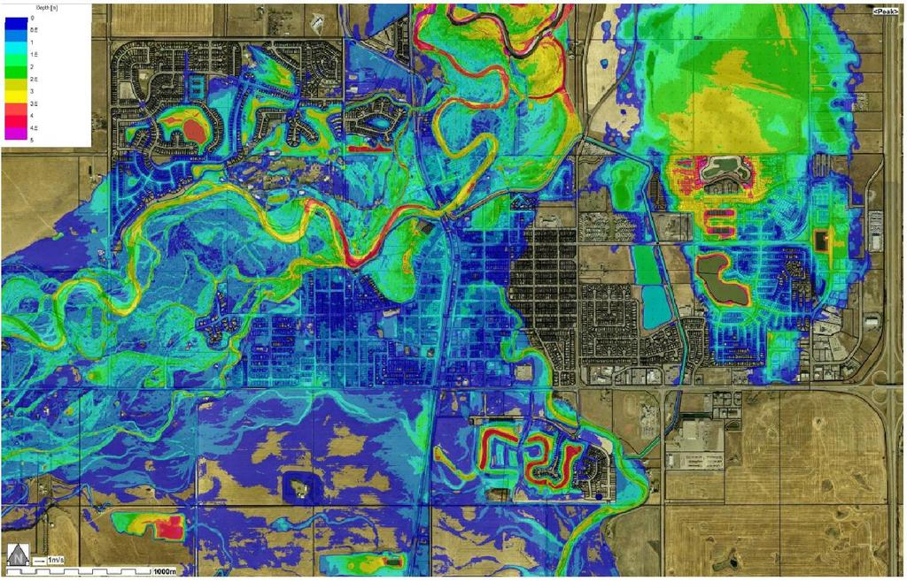
2 Table of Contents page Sign-Off 1. Flood Damage in Background Town of High River Summary of Flood Damage Costs in River Basin... 2 List of Figures Figure 1-1: Depth of flooding in Town of High River in June (From Figure 15 in "2013 Flood Mitigation Master Plan - Town of High River, Alberta" by WorleyParsons Canada for Town of High River, 1 October 2013)... 3 List of Tables Table 1-1: Provincial Disaster Recovery Program Claims... 1 Table 1-2: Municipal DRP and Erosion Control Grants... 2 RPT App_A_Highwood_River_Flood_Damage_In_2013.Docx


3
4 1. Flood Damage in Background The Town of High River is the largest community in the Highwood River basin, with a population of 12,920 (2011 census). Large floods occurred in 1894, 1899, 1902, 1908, 1912, 1923, 1929, 1932, 1942, 1995 and The June 2013 flood caused the most costly damages to date in the Town of High River and also caused significant erosion along the entire river. The magnitude of the damage in 2013 is directly related to extent and location of the development of the town compared to earlier years. During the 2013 flood, significant erosion and sediment deposition occurred along the Highwood River. However, river channel erosion and deposition is a natural evolutionary process of rivers and should be allowed to progress as far as practical. 1.2 Town of High River The June 2013 flood covered a very large part of the town and forced the evacuation of the entire town. Three people drowned in the Highwood River during the flood. The Town of High River suffered extensive damages during the June 2013 flood. Under the Provincial Disaster Recovery Program, the following number of claims had been submitted by the end of 2013: Table 1-1: Provincial Disaster Recovery Program Claims Claim Type Number of Claims Small Businesses 362 Condominiums 21 Homes 2,739 Institutions 27 Landlords 305 Tenants 1,106 During the flood, the Highwood River channel eroded significantly and caused lateral shifts along the river channel. The river bed was re-shaped by scour and deposition and by August 2013, scalping of the depositions were in progress at several locations to remove more than 60,000 m 3 of gravel and cobbles from the river channel. Highway 2A crosses the Highwood River in the middle of the town and an abandoned CP railway crosses the river parallel to and immediately upstream (west) of the highway bridge. During the flood, the railway bridge caused a constriction and the south approach to the bridge was partly washed out, thereby threatening the highway. Immediately downstream of the highway bridge is the off-take structure for the Little Bow River diversion. This diversion diverts up to 8 m 3 /s into the Little Bow Canal system for irrigation purposes. During the 2013 flood, the flood waters overtopping the right river bank washed out parts of the dykes along the Little Bow Canal. RPT App_A_Highwood_River_Flood_Damage_In_2013.Docx 1
5 1.3 Summary of Flood Damage Costs in River Basin The Alberta Government assists communities in their re-construction through their Municipal Disaster Recovery Program (DRP) and Erosion Control Grant program. The DRP covers repairs and restoration of existing infrastructure to a pre-disaster state. Table 1-2: Municipal DRP and Erosion Control Grants Type Location Amount (million) Municipal DRP Submissions Town of High River Various locations within MD of Foothills $79.7 $1.5 Erosion Control Grant Applications Town of High River Various locations within MD of Foothills $10.4 $2.6 All combined Highwood River basin $94.2 It should be noted that the above costs are those available to AECOM at the time of preparation of this report. The cost for MD of Foothills is specific to the Highwood River basin and was estimated from a summary report for the MD provided by the Flood Recovery Task Force. At the time of preparation of this report, the costs incurred by individuals and businesses were unavailable to AECOM. RPT App_A_Highwood_River_Flood_Damage_In_2013.Docx 2
6
HYDROLOGY AND HYDRAULICS MUSKEG RIVER BRIDGE
 PUBLIC WORKS CANADA HYDROLOGY AND HYDRAULICS MUSKEG RIVER BRIDGE KILOMETRE 207.9, LIARD HIGKWAY December 1978 I I f I I I I # Bolter Parish Trimble Ltd. ONLIULTINO Public Works, Canada, 9925-109 Street,
Pirai river (Bolivia)
") Pirai river (Bolivia) Confluent of the Amazon river which average discharge is only 6 m3/s, but with peak discharge over 5000 m3/s, a challenge for river basin management and for flood control HYDROEUROPE
Pirai river (Bolivia) Confluent of the Amazon river which average discharge is only 6 m3/s, but with peak discharge over 5000 m3/s, a challenge for river basin management and for flood control HYDROEUROPE
APPENDIX A M&T/Llano Seco Long-Term Water Reliability Study These photos are examples of rock spurs in use throughout the United States
 APPENDIX A M&T/Llano Seco Long-Term Water Reliability Study These photos are examples of rock spurs in use throughout the United States Glenn Colusa Irrigation District completed a Sacramento River project
RAILWAYS AND FISH: HOW TO PROTECT AND ENHANCE FISH HABITAT VALUES AT STREAM CROSSINGS THROUGH PROJECT DESIGN AND CONSTRUCTION
 RAILWAYS AND FISH: HOW TO PROTECT AND ENHANCE FISH HABITAT VALUES AT STREAM CROSSINGS THROUGH PROJECT DESIGN AND CONSTRUCTION Rail Environment Conference November 2016 AGENDA Objective Background Benefits
Experimental Study on Effect of Houses on Debris-Flow Flooding and Deposition in Debris Flow Fan Areas
 DATA ACQUISITION AND MODELLING (MONITORING, PROCESSES, TECHNOLOGIES, MODELS) Experimental Study on Effect of Houses on Debris-Flow Flooding and Deposition in Debris Flow Fan Areas Kana Nakatani, Dr. 1
Dolores River Watershed Study
 CHAPTER 4: RIVER AND FLOODPLAIN ISSUES The Dolores River falls into a category of streams in Colorado that share some unique characteristics. Like some other mountain streams in the state, it has a steep
Field Observations and One-Dimensional Flow Modeling of Summit Creek in Mack Park, Smithfield, Utah
 Intermountain Center for River Rehabilitation and Restoration, Utah State University 31 July 2018 Field Observations and One-Dimensional Flow Modeling of Summit Creek in Mack Park, Smithfield, Utah I.
The last three sections of the main body of this report consist of:
 Threatened and Endangered Species Geological Hazards Floodplains Cultural Resources Hazardous Materials A Cost Analysis section that provides comparative conceptual-level costs follows the Environmental
Grant 0299-NEP: Water Resources Project Preparatory Facility
 Document Produced under Grant Project Number: 45206 May 2016 Grant 0299-NEP: Water Resources Project Preparatory Facility Final Report Volume 3 East Rapti (1 of 9) Prepared by Pvt. Ltd. For Ministry of
Flood Forecasting Methodology in Alberta
 Flood Forecasting Methodology in Alberta Evan Friesenhan, M.Eng., P.Eng Alberta Environment and Sustainable Resource Development March 17, 2014 River Forecast Team Mandate To provide Albertans with information
Project Proposal. Lyme Brook. Newcastle-under-Lyme. 3 rd July 2015
 Project Proposal Lyme Brook Newcastle-under-Lyme 3 rd July 2015 Contents Page 1.0 Introduction... 1.0 2.0 Background and rationale... 2.0 3.0 Proposed measures... 5 4.0 Summary of Recommendations... 10
The Great Flood: Alberta s biblical deluge of Jon Noad
 The Great Flood: Alberta s biblical deluge of 2013 Jon Noad CSPG October 22, 2014 Brief note Tens of thousands have been killed worldwide in floods this decade; we were relatively lucky in Alberta. EUROPE
Assessment. Assessment
 2001 SPRINGBROOK CREEK RESTORATION - THREE YEAR POST-CONSTRUCTION REVIEW - Presented by Bruce Henderson and Andy Harris 2005 River Restoration Northwest Symposium Skamania Lodge, Washington www.hendersonlandservices.com
Stream Geomorphology. Leslie A. Morrissey UVM July 25, 2012
 Stream Geomorphology Leslie A. Morrissey UVM July 25, 2012 What Functions do Healthy Streams Provide? Flood mitigation Water supply Water quality Sediment storage and transport Habitat Recreation Transportation
Section 5. Low-Gradient Streams. What Do You See? Think About It. Investigate. Learning Outcomes
 Chapter 4 Surface Processes Section 5 Low-Gradient Streams What Do You See? Learning Outcomes In this section, you will Use models and real-time streamflow data to understand the characteristics of lowgradient
R.M.HARW & ASSOCIATES LTD. GEOTECHNICAL INVESTIGATION PROPOSED BRIDGE SITE. HELAVA CREEKl MILE MACKENZIE HIGHWAY E-2510 OCTOBER 16, 1973
 El R.M.HARW & ASSOCIATES LTD. GEOTECHNICAL INVESTIGATION PROPOSED BRIDGE SITE HELAVA CREEKl MILE 616.4 MACKENZIE HIGHWAY E-2510 OCTOBER 16, 1973 R,M,HARDV & ASSOCIATES LTD. CONSULTING ENGINEERING & TESTING
Flood Forecasting Methodology in Alberta
 Flood Forecasting Methodology in Alberta Colleen Walford, P.Eng Alberta Environment and Sustainable Resource Development March 24, 2014 River Forecast Team Mandate To provide Albertans with information
Flood Forecasting Methodology in Alberta
 Flood Forecasting Methodology in Alberta Evan Friesenhan, M.Eng., P.Eng Alberta Environment and Sustainable Resource Development February 18, 2014 River Forecast Team Mandate To provide Albertans with
Appendix E Rosgen Classification
 Appendix E Stream Type s Using the morphometric parameters described above, stream reaches are classified into 7 major stream types (Aa+ through G) based on s (1996) criteria. The relevant stream classifications
Physical landscapes River landscapes in the UK
 Physical landscapes River landscapes in the UK The shape of river valleys change s as rivers flow downstream - PROCESSES Erosion Abrasion or corrasion Attrition Hydraulic Action Solution or corrosion Deposition
Hydro-engineers.ch HEC-RAS ANALAYSIS. River: L Aïre Mesfin Tewolde. Hydro-engineers.ch 23 oct. 2017
 Hydro-engineers.ch HEC-RAS ANALAYSIS River: L Aïre Mesfin Tewolde 17 Hydro-engineers.ch 23 oct. 2017 PREPARED BY MESFIN TEWOLDE [TEMPORARY MISSION] Hydro-engineers.ch HEC-RAS ANALYSIS [January- March 2014]
Chapter 3 Erosion in the Las Vegas Wash
 Chapter 3 Erosion in the Las Vegas Wash Introduction As described in Chapter 1, the Las Vegas Wash (Wash) has experienced considerable change as a result of development of the Las Vegas Valley (Valley).
SCOUR AND EROSION ALONGSIDE BANK PROTECTION WORK: CASE STUDIES FROM BANGLADESH
 SCOUR AND EROSION ALONGSIDE BANK PROTECTION WORK: CASE STUDIES FROM BANGLADESH KNUT OBERHAGEMANN Northwest Hydraulic Consultants Lt. 4823 99 th Street Edmonton, Alberta T6E 4Y1, Canada ABDUN NOOR Bangladesh
AASHTO Extreme Weather Events Symposium Vermont s Road and Rivers - Managing for the Future
 AASHTO Extreme Weather Events Symposium Vermont s Road and Rivers - Managing for the Future May 22, 2013 PLANET EARTH 2 2 MANY MANYYEARS AGO 23,000 years ago there was more than 8,000 feet of glacier over
6.11 Naas River Management Unit
 6.11 Naas River Management Unit 6.11.1 Site 41 Issue: Bed and bank erosion Location: E 0685848 N 6058358 Waterway: Naas River Management Unit: Naas River Facing downstream from Bobeyan Rd bridge Facing
CR AAO Bridge. Dead River Flood & Natural Channel Design. Mitch Koetje Water Resources Division UP District
 CR AAO Bridge Dead River Flood & Natural Channel Design Mitch Koetje Water Resources Division UP District Old County Road AAO Bridge Map courtesy of Marquette County Silver Lake Basin McClure Basin
Field Trip Number One. By: Pat Dryer. Geography 360
 Field Trip Number One By: Pat Dryer Geography 360 Table of Contents Introduction. Page 1 Stop One... Page 2 Stop Two... Page 4 Stop Three... Page 5 Stop Four... Page 7 Bibliography Page 8 Campus Map Source:
MATHEMATICAL MODELING OF FLUVIAL SEDIMENT DELIVERY, NEKA RIVER, IRAN. S.E. Kermani H. Golmaee M.Z. Ahmadi
 JOURNAL OF ENVIRONMENTAL HYDROLOGY The Electronic Journal of the International Association for Environmental Hydrology On the World Wide Web at http://www.hydroweb.com VOLUME 16 2008 MATHEMATICAL MODELING
Indigenous technical knowledge for bank erosion and flood management
 2017 APEC Typhoon Symposium, May 2 4, 2017, GIS NTU Convention Center, Taipei Indigenous technical knowledge for bank erosion and flood management Hao Zhang 1) and Hajime Nakagawa 2) 1) Associate Professor,
Learning Objectives: I can identify and interpret river flows and directions.
 Learning Objectives: I can identify and interpret river flows and directions. Bellringer Review: Check for Understanding Questions: 1 2 What Are The Key Parts Of A River s Anatomy? In your data notebooks
Strategies for managing sediment in dams. Iwona Conlan Consultant to IKMP, MRCS
 Strategies for managing sediment in dams Iwona Conlan Consultant to IKMP, MRCS 1 Sediment trapping by dams Active storage capacity Dead storage coarse material (bed load) Fine materials (suspension) Francis
Effects of extreme rainfall on geotechnical hazards in the Canadian Rocky Mountains
 NGM 2016 Reykjavik Proceedings of the 17 th Nordic Geotechnical Meeting Challenges in Nordic Geotechnic 25 th 28 th of May Effects of extreme rainfall on geotechnical hazards in the Canadian Rocky Mountains
Project (Project No. US-CA-62-2) Maintenance Inspection and Reports (Subtask 14.1) Inspection Report No.2
 Maintenance Inspection and Reports (Subtask 14.1) Inspection Report No.2") MEMORANDUM TO: FROM: Jim Well, Ducks Unlimited Mike Harvey, PhD, PG SUBJECT: M&T/ Llano Seco Fish Screen Project (Project No. US-CA-62-2) Maintenance Inspection and Reports (Subtask 14.1) Inspection Report
MEMORANDUM TO: FROM: Jim Well, Ducks Unlimited Mike Harvey, PhD, PG SUBJECT: M&T/ Llano Seco Fish Screen Project (Project No. US-CA-62-2) Maintenance Inspection and Reports (Subtask 14.1) Inspection Report
Water flowing in the stream can move sediments along the stream channel because of an exchange of energy from the
 1. Base your answer(s) to the following question(s) on the Earth Science Reference Tables, the diagram below, and your knowledge of Earth science. The diagram represents a laboratory stream table. Water
A STUDY OF LOCAL SCOUR AT BRIDGE PIERS OF EL-MINIA
 A STUDY OF LOCAL SCOUR AT BRIDGE PIERS OF EL-MINIA Dr. Gamal A. Sallam 1 and Dr. Medhat Aziz 2 ABSTRACT Bridges are critical structures that require a substantial investment to construct and serve an important
Island 32 Erosion. prepared for Ministry of Environment, Lands and Parks A Street Surrey, British Columbia, V3R 7P8. and
 Island 32 Erosion prepared for Ministry of Environment, Lands and Parks 10334 152A Street Surrey, British Columbia, V3R 7P8 and District of Chilliwack 8550 Young Road Chilliwack, British Columbia, V2P
Hydraulics Prof. Dr. Arup Kumar Sarma Department of Civil Engineering Indian Institute of Technology, Guwahati
 Hydraulics Prof. Dr. Arup Kumar Sarma Department of Civil Engineering Indian Institute of Technology, Guwahati Module No. # 04 Gradually Varied Flow Lecture No. # 07 Rapidly Varied Flow: Hydraulic Jump
Intense Precipitation Events and Flooding
 Intense Precipitation Events and Flooding Climate Disruption & Our Water Future: Mitigate, Adapt or Suffer A Call for New Strategies Middle Rio Grande Water Assembly Saturday, March 21, 2015 Michael Jensen
LOCATIONS OF SELECTED MITIGATION SITES IN JAPAN
 LOCATIOS OF SELECTED MITIGATIO SITES I JAPA Hyogo prefecture near Kobe, Japan Hyogo province Gifu province Osaka Kobe Gifu prefecture near Takayama, Japan akao Kamikochi ational Park Mount Yake Tateyama
Summary of Hydraulic and Sediment-transport. Analysis of Residual Sediment: Alternatives for the San Clemente Dam Removal/Retrofit Project,
 Appendix N SUMMARY OF HYDRAULIC AND SEDIMENT-TRANSPORT ANALYSIS OF RESIDUAL SEDIMENT: ALTERNATIVES FOR THE SAN CLEMENTE DAM REMOVAL/RETROFIT PROJECT, CALIFORNIA the San Clemente Dam Removal/Retrofit Project,
June 9, R. D. Cook, P.Eng. Soils Engineer Special Services Western Region PUBLIC WORKS CANADA WESTERN REGION REPORT ON
 PUBLIC WORKS CANADA WESTERN REGION REPORT ON GEOTECHNICAL INVESTIGATION PROPOSED MARTIN RIVER BRIDGE MILE 306.7 MACKENZIE HIGHWAY Submitted by : R. D. Cook, P.Eng. Soils Engineer Special Services Western
GEOMORPHIC CHANGES IN LOWER CACHE CREEK 2012
 GEOMORPHIC CHANGES IN LOWER CACHE CREEK 2012 Eric W. Larsen Technical Memorandum Prepared for Cache Creek Technical Advisory Committee Natural Resources Program Yolo County Board of Supervisors 2012 Prepared
CFD Modeling for Structure Designs in Environmental Impacts Mitigation
 CFD Modeling for Structure Designs in Environmental Impacts Mitigation June 05 Navid Nekouee, Hugo Rodriguez and Steven Davie Environmental Impact Mitigation Design Savannah Harbor Expansion Project (SHEP)
Technical Memorandum No
 Pajaro River Watershed Study in association with Technical Memorandum No. 1.2.10 Task: Evaluation of Four Watershed Conditions - Sediment To: PRWFPA Staff Working Group Prepared by: Gregory Morris and
ERDC/LAB TR-0X-X 100. Figure 7-3 Maximum velocity magnitudes for existing conditions for 100-year flood event
 ERDC/LAB TR-0X-X 100 Figure 7-3 Maximum velocity magnitudes for existing conditions for 100-year flood event ERDC/LAB TR-0X-X 101 Figure 7-4 Model schematization of Option 1 Figure 7-5 Bed displacement
In-channel coarse sediment trap Best Management Practice
 In-channel coarse sediment trap Best Management Practice By Henry R. Hudson July 2002 Environmental Management Associates Ltd., Christchurch Complexity Environmental Value Cost Low Moderate High Low Moderate
Floods Lecture #21 20
 Floods 20 Lecture #21 What Is a Flood? Def: high discharge event along a river! Due to heavy rain or snow-melt During a flood, a river:! Erodes channel o Deeper & wider! Overflows channel o Deposits sediment
APPENDIX B Hydraulic Considerations for Pipeline Crossings of Stream Channels
 APPENDIX B Hydraulic Considerations for Pipeline Crossings of Stream Channels B-1 B-2 APPENDIX B HYDRAULIC CONSIDERATIONS FOR PIPELINE CROSSINGS OF STREAM CHANNELS Pipeline crossings of perennial, intermittent,
Technical note about the monitoring of hydromorphological restoration/management of the Drava River in Slovenia
 Technical note about the monitoring of hydromorphological restoration/management of the Drava River in Slovenia 1 Project: HyMoCARES Work package: WPC. Communication Activity: Web Site Deliverable: Case
PR206 NARRATIVE Updated 16 June 2015
 PR206 NARRATIVE Updated 16 June 2015 Cross section PR206 was established in 1977 in a fairly straight reach of Powder River about a kilometer downriver of the Highway 212 bridge at Broadus. The section
Annotated Bibliography of River Avulsions Pat Dryer Geography 364 5/14/2007
 Annotated Bibliography of River Avulsions Pat Dryer Geography 364 5/14/2007 1 Table of Contents Introduction 2 Annotations I. River avulsions and their deposits 2 II. Channel avulsion on alluvial fans
1. INTRODUCTION. EXAMPLE OF SECHILIENNE ROCKFALL (France)
") FORM OSE POST-GRADUATE COURSE Landslide vulnerability and risk 1 FORM OSE POST-GRADUATE COURSE Landslide vulnerability and risk 2 FORM OSE POST-GRADUATE COURSE Landslide vulnerability and risk 3 Christophe
FORM OSE POST-GRADUATE COURSE Landslide vulnerability and risk 1 FORM OSE POST-GRADUATE COURSE Landslide vulnerability and risk 2 FORM OSE POST-GRADUATE COURSE Landslide vulnerability and risk 3 Christophe
Earth Science Floods
 Non-fiction: Earth Science - Floods Earth Science Floods When dry land is covered by water, we call it a flood. Floods are very dangerous. If they are very bad, homes can be destroyed, and people can die.
Managing Floods at Boscastle. Learning Objective: Examine the benefits of managing floods
 Managing Floods at Boscastle Learning Objective: Examine the benefits of managing floods Learning Outcomes: Describe how Boscastle has been affected by flooding Explain strategies to reduce the risk Evaluate
Working with Natural Stream Systems
 Working with Natural Stream Systems Graydon Dutcher Delaware County Soil & Water Conservation District Stream Corridor Management Program Tropical Storm Sandy October 29,2012 What is a Watershed?
Countermeasure Calculations and Design
 Countermeasure Calculations and Design Summarized from Bridge Scour and Stream Instability Countermeasures, Experience, Selection, and Design Guidance, Second Edition, Publication No. FHWA NHI 01-003,
Controlling Processes That Change Land
 1 Name Date Controlling Processes That Change Land People try to control some of the processes that change land. To do this, people apply technology- the use of science to solve problems in everyday life.
Bowen Collinsville Enterprise Don River Sand and Flooding Briefing Report Prepared and presented by John Finlay April 9 th 2013
 Bowen Collinsville Enterprise Don River Sand and Flooding Briefing Report Prepared and presented by John Finlay April 9 th 2013 1 Bowen Collinsville Enterprise Briefing Report on Don River 1. The Don River
Technical Memorandum No Sediment Model
 Pajaro River Watershed Study in association with Technical Memorandum No. 1.2.9 Sediment Model Task: Development of Sediment Model To: PRWFPA Staff Working Group Prepared by: Gregory Morris and Elsie Parrilla
Rebuilding Flood-Conscious Society
 A zone where strong flood flow or river bank erosion by levee breach are anticipated, which likely to occur collapsing/washing away of house. Set up the joint councils by relative stakeholders(river managers,
EFFECT OF STREAM-WISE SPACING OF BRIDGE PIERS ON SCOUR DEPTH
 EFFECT OF STREAM-WISE SPACING OF BRIDGE PIERS ON SCOUR DEPTH ASHISH KUMAR Ph. D. Student UMESH C. KOTHYARI Professor Department of Civil Engineering Indian Institute of Technology, (formerly: University
Effect of the barrage and embankments on flooding and channel avulsion case study Koshi River, Nepal
 Effect of the barrage and embankments on flooding and channel avulsion case study Koshi River, Nepal Lochan Devkota 1, Alessandra Crosato 2, Sanjay Giri 3 1 Mott MacDonald Singapore Pte Ltd Grange Road,
A3 RIVER BASIN AND RIVER CHANNEL
 Part-A: Existing Conditions A3 RIVER BASIN AND RIVER CHANNEL A3.1 Basin The Limboto-Bolango-Bone (LBB) basin has a total catchment area of about 27 km 2 and is shaped rectangle extending about 1 km from
The Lynmouth Flood 1952 Student Assignment
 The Lynmouth Flood 1952 Student Assignment Name Group Section Points Score Where is Lynmouth? 7 The Weather 10 Exmoor 8 The East Lyn Valley 11 Human Factors 10 Bridges 14 Changes in Lynmouth 12 Flood defences
Evaluation of Scour Depth around Bridge Piers with Various Geometrical Shapes
 Evaluation of Scour Depth around Bridge Piers with Various Geometrical Shapes Dr. P. D. Dahe * Department of Civil Engineering, SGGSIE&T, Vishnupuri, Nanded (Maharashtra) S. B. Kharode Department of Civil
ICHE 2014, Hamburg - Lehfeldt & Kopmann (eds) Bundesanstalt für Wasserbau ISBN
 Bundesanstalt für Wasserbau ISBN") ICHE 2014, Hamburg - Lehfeldt & Kopmann (eds) - 2014 Bundesanstalt für Wasserbau ISBN 978-3-939230-32-8 Comparison of Physical Model Predictions and Prototype Measurements of Fluvial Morphodynamics in
ICHE 2014, Hamburg - Lehfeldt & Kopmann (eds) - 2014 Bundesanstalt für Wasserbau ISBN 978-3-939230-32-8 Comparison of Physical Model Predictions and Prototype Measurements of Fluvial Morphodynamics in
33. Eroding downstream left bank, new bridge, Attlebridge (TG ).
.") 33. Eroding downstream left bank, new bridge, Attlebridge (TG 12831675). 58 34. Eroding upstream right bank at Attlebridge Hall (TG 13871557), ford and cattle crossing. 35. Eroding upstream left bank at
33. Eroding downstream left bank, new bridge, Attlebridge (TG 12831675). 58 34. Eroding upstream right bank at Attlebridge Hall (TG 13871557), ford and cattle crossing. 35. Eroding upstream left bank at
APPENDIX A REACH DECRIPTIONS. Quantico Creek Watershed Assessment April 2011
 APPENDIX A REACH DECRIPTIONS Basin 615, South Fork of Quantico Creek - Project Reach Descriptions Reach Name: 615-A Coordinates (NAD 83, Virginia State Plane North): 11796510.57, 6893938.95 to 11801555.79,
Hazard Resilience Index (HRI) Earthquakes, Tsunamis, and Volcanoes
 Earthquakes, Tsunamis, and Volcanoes") Hazard Index (HRI) Earthquakes, Tsunamis, and Volcanoes Earthquakes Tsunamis Volcano-Ash Falls, Projectiles and Lateral Blasts, Pyroclastic Flows and Lava Flows Earthquakes, Tsunamis and Volcanoes Please
Hazard Index (HRI) Earthquakes, Tsunamis, and Volcanoes Earthquakes Tsunamis Volcano-Ash Falls, Projectiles and Lateral Blasts, Pyroclastic Flows and Lava Flows Earthquakes, Tsunamis and Volcanoes Please
SUPPLEMENTARY INFORMATION
 SUPPLEMENTARY INFORMATION Supplementary Information Rapid formation of a modern bedrock canyon by a single flood event Michael P. Lamb 1 and Mark A. Fonstad 2 1 California Institute of Technology, Geological
CHAPTER FIVE: THE LOWER MISSISSIPPI REGION AND PLAQUEMINES PARISH
 CHAPTER FIVE: THE LOWER MISSISSIPPI REGION AND PLAQUEMINES PARISH 5.1 Overview Plaquemines Parish is the area where the last portion of the Mississippi River flows out into the Gulf of Mexico (see Figures
7.3 Sediment Delivery Analysis
 7.3 Sediment Delivery Analysis In order to evaluate potential changes in sedimentation patterns that could occur due to impacts from the FCP and LPP alignments, sediment assessment models were constructed
Rivers and Streams. Streams. Hydrologic Cycle. Drainage Basins and Divides. Colorado River Drainage Basin. Colorado Drainage Basins.
 Chapter 14 Hydrologic Cycle Rivers and Streams Streams A stream is a body of water that is confined in a channel and moves downhill under the influence of gravity. This definition includes all sizes of
The effectiveness of check dams in controlling upstream channel stability in northeastern Taiwan
 Erosion, Debris Mows and Environment in Mountain Regions (Proceedings of the Chengdu Symposium, July 1992). IAHS Publ. no. 209, 1992. 423 The effectiveness of check dams in controlling upstream channel
BUILDING STRUCTURES ON OR NEAR STEEP SLOPES
 BUILDING STRUCTURES ON OR NEAR STEEP SLOPES Benefits of Building Structures on or Near Steep Slopes Why would you ever do this? In some instances, it is the steep slope that people want to be near. Like
EAGLES NEST AND PIASA ISLANDS
 EAGLES NEST AND PIASA ISLANDS HABITAT REHABILITATION AND ENHANCEMENT PROJECT MADISON AND JERSEY COUNTIES, ILLINOIS ENVIRONMENTAL MANAGEMENT PROGRAM ST. LOUIS DISTRICT FACT SHEET I. LOCATION The proposed
Step 5: Channel Bed and Planform Changes
 Step 5: Channel Bed and Planform Changes When disturbed, streams go through a series of adjustments to regain equilibrium with the flow and sediment supply of their watersheds. These adjustments often
Use of Geospatial data for disaster managements
 Use of Geospatial data for disaster managements Source: http://alertsystemsgroup.com Instructor : Professor Dr. Yuji Murayama Teaching Assistant : Manjula Ranagalage What is GIS? A powerful set of tools
GENERAL SUMMARY BIG WOOD RIVER GEOMORPHIC ASSESSMENT BLAINE COUNTY, IDAHO
 GENERAL SUMMARY BIG WOOD RIVER GEOMORPHIC ASSESSMENT BLAINE COUNTY, IDAHO Prepared For Trout Unlimited 300 North Main Street, Hailey, Idaho, 83333 Prepared By P. O. Box 8578, 140 E. Broadway, Suite 23,
Black Gore Creek 2013 Sediment Source Monitoring and TMDL Sediment Budget
 Black Gore Creek 2013 Sediment Source Monitoring and TMDL Sediment Budget Prepared for: Prepared By: - I. Introduction The Black Gore Creek Total Maximum Daily Load (TMDL) was developed in collaboration
Solutions to Flooding on Pescadero Creek Road
 Hydrology Hydraulics Geomorphology Design Field Services Photo courtesy Half Moon Bay Review Solutions to Flooding on Pescadero Creek Road Prepared for: San Mateo County Resource Conservation District
The Effects of Hydraulic Structures on Streams Prone to Bank Erosion in an Intense Flood Event: A Case Study from Eastern Hokkaido
 Symposium Proceedings of the INTERPRAENENT 2018 in the Pacific Rim The Effects of Hydraulic Structures on Streams Prone to Bank Erosion in an Intense Flood Event: A Case Study from Eastern Hokkaido Daisuke
An environmentally sensitive erosion control technique in the Mekong River Delta: 10 years on
 7 th Australian Stream Management Conference - Full Paper An environmentally sensitive erosion control technique in the Mekong River Delta: 10 years on John Tilleard 1, Tony Ladson 2 1 Moroka Pty Ltd,
CHANGES OF RUNOFF MECHANISM OF THE BRANTAS RIVER OVER THE PAST 30 YEARS
 CHANGES OF RUNOFF MECHANISM OF THE BRANTAS RIVER OVER THE PAST 30 YEARS TOSHIKATSU OMACHI Infrastructure Development Institute KATUMI MUSIAKE Fukushima University The Brantas River in the East Java originates
3/3/2013. The hydro cycle water returns from the sea. All "toilet to tap." Introduction to Environmental Geology, 5e
 Introduction to Environmental Geology, 5e Running Water: summary in haiku form Edward A. Keller Chapter 9 Rivers and Flooding Lecture Presentation prepared by X. Mara Chen, Salisbury University The hydro
Fluvial Geomorphology Assessment of Northern Connecticut River Tributaries
 Fluvial Geomorphology Assessment of Northern Connecticut River Tributaries Final Report Upper Ammonoosuc River in Stark, NH Prepared for Connecticut River Joint Commissions Charlestown, New Hampshire Prepared
Tom Ballestero University of New Hampshire. 1 May 2013
 Tom Ballestero University of New Hampshire 1 May 2013 1 Hydrology 2 Basic Hydrology Low flows most common Flows that fill the stream to the banks and higher are much less common Filling the stream to the
Some Known Dam Failures in British Columbia
 Some Known Dam Failures in British Columbia This list contains the some known failures of manmade dams in British Columbia. It does not list failures of beaver dams (which can have severe consequences),
Degradation Concerns related to Bridge Structures in Alberta
 Degradation Concerns related to Bridge Structures in Alberta Introduction There has been recent discussion regarding the identification and assessment of stream degradation in terms of how it relates to
PR122A NARRATIVE Updated 25 July 2014
 PR122A NARRATIVE Updated 25 July 2014 Cross section PR122A was established in 1979 across a new cutoff channel that had formed during the 1978 flood across the neck of a meander bend in Powder River at
2. PRESENT CONDITION OF THE RESERVOIR 2.1 View of Wonogiri Reservoir (1/3)
") 2.1 View of Wonogiri Reservoir (1/3) Wonogiri dam abutment on the left side of dam Spillway forebay on thet left side of dam Bank erosion around Wonogiri reservoir. Wonogiri Dam view from chersonese. An
2.1 View of Wonogiri Reservoir (1/3) Wonogiri dam abutment on the left side of dam Spillway forebay on thet left side of dam Bank erosion around Wonogiri reservoir. Wonogiri Dam view from chersonese. An
CONTENT. Guillermo Soto Conde Ingeciencia. Emilio Arturo Hernández Chaupis Compañia Operadora de Gas del Amazonas
 Emilio Arturo Hernández Chaupis Compañia Operadora de Gas del Amazonas CLICK TO EDIT Edward MASTER Francisco Oliveros TITLE Montes STYLE Compañia Operadora de Gas del Amazonas Guillermo Soto Conde Ingeciencia
UGRC 144 Science and Technology in Our Lives/Geohazards
 UGRC 144 Science and Technology in Our Lives/Geohazards Flood and Flood Hazards Dr. Patrick Asamoah Sakyi Department of Earth Science, UG, Legon College of Education School of Continuing and Distance Education
Effectiveness of Gabions Dams on Sediment Retention: A Case Study
 Journal of Environmental Science and Engineering A 5 (2016) 516-521 doi:10.17265/2162-5298/2016.10.004 D DAVID PUBLISHING Effectiveness of Gabions Dams on Sediment Retention: A Case Study Leandro Velázquez-Luna
Suspended sediment yields of rivers in Turkey
 Erosion and Sediment Yield: Global and Regional Perspectives (Proceedings of the Exeter Symposium, July 1996). IAHS Publ. no. 236, 1996. 65 Suspended sediment yields of rivers in Turkey FAZLI OZTURK Department
A SIMPLE GIS METHOD FOR OBTAINING FLOODED AREAS
 A SIMPLE GIS METHOD FOR OBTAINING FLOODED AREAS ROMAN P., I. 1, OROS C., R. 2 ABSTRACT. A simple GIS method for obtaining flooded areas. This paper presents a method for obtaining flooded areas near to
STABILIZATION OF THE H&CT RAILWAY STONE DAM WALTER E. SKIPWITH, PE, JOYCE CRUM, AIA AND JOHN BAUMGARTNER, PE. Introduction.
 STABILIZATION OF THE H&CT RAILWAY STONE DAM WALTER E. SKIPWITH, PE, JOYCE CRUM, AIA AND JOHN BAUMGARTNER, PE I. A. Introduction General The Old Stone Dam is located in the upper reach of Cottonwood Creek
CONSIDERATIONS ON URBAN AREAS AND FLOATING DEBRIS IN DAM -BREAK FLOOD MODELLING. Peter Reiter *)
") 1 CONSIDERATIONS ON URBAN AREAS AND FLOATING DEBRIS IN DAM -BREAK FLOOD MODELLING. Peter Reiter *) 1. SUMMARY Every model is a story, describing real-life and more or less significant simplifications are
1 CONSIDERATIONS ON URBAN AREAS AND FLOATING DEBRIS IN DAM -BREAK FLOOD MODELLING. Peter Reiter *) 1. SUMMARY Every model is a story, describing real-life and more or less significant simplifications are
APPENDIX E. GEOMORPHOLOGICAL MONTORING REPORT Prepared by Steve Vrooman, Keystone Restoration Ecology September 2013
 APPENDIX E GEOMORPHOLOGICAL MONTORING REPORT Prepared by Steve Vrooman, Keystone Restoration Ecology September 2 Introduction Keystone Restoration Ecology (KRE) conducted geomorphological monitoring in
Born in Unzen The World s First Unmanned Construction of Multilayer Sediment Control Dam Using Sediment Forms Unzen Restoration Project Office
 Born in Unzen The World s First Unmanned Construction of Multilayer Sediment Control Dam Using Sediment Forms Unzen Restoration Project Office Unzen Restoration Project Office Kyushu Regional Construction