COMINCO LTD. GRID A VINE CLAIM GROUP. Fort Steele Mining Division 82G/5. Sulilnit t ed by :
|
|
|
- Gervais Mitchell
- 5 years ago
- Views:
Transcription
1 COMNCO LTD. EXPLORATON DVSON WESTERN DSTRCT REPORT ON GEOCHEMCAL SURVEY GRD A VNE CLAM GROUP Fort Steele Mining Division 82G/5 Sulilnit t ed by : E.W. BATCHELOR Cominco Ltd. Kootenay Exploration 2450 Cranbrook Street Cranbrook, B.C. Under the supervision of: D.W. HEDDLE, P. Eng.
2 COMNCO LTD. EXPLORATON DVSON WESTERN DSTRCT - J REPORT ON GEOCHEMCAL SURVEY GRD A VNE CLAM GROUP Fort Steele Mining Division 82G/5 Submitted by: E.W. BATCHELOR Under the supervision of:
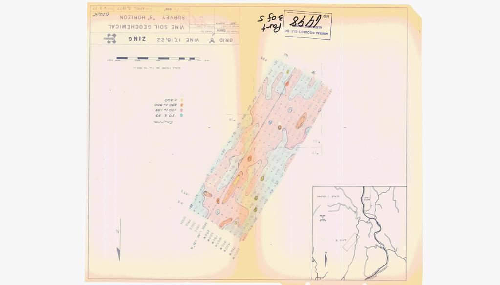
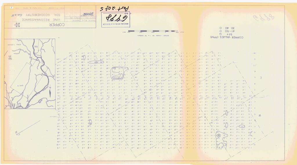
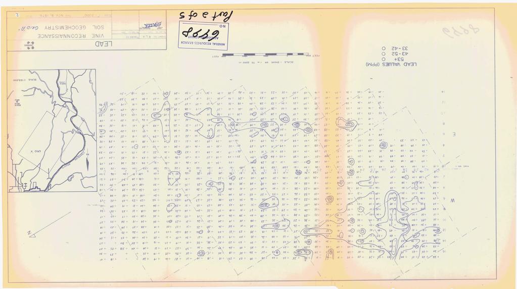
3 COMNCO LTD. EXPLORATON DVSON WESTERN DSTRC3 TABLE OF CONTENTS PAGE 1.00 SUMMARY NTRODUCTON Status of Ownership LocationandAccess Topography and Vegetation Objective GEOCHEMSTRY Sampling Procedure Sample Preparation and Analysis NTERPRETATON AND RESULTS STATEMENT OF EXPENDTURES STATEMENT OF QUfkFCATONS PLATE 1. Location Map. FGURE 1. Cu - Cummulative Frequency Distribution FGURE 2. FGURE 3. Pb - Cumulative Frequency Distribution Zn - Cummulative Frequency Distribution
4 COMNCO LTD. EXPLOR4TON DVSON WESTERN DSTRCT 1.00 SUMMARY Grid l1al1 covers a portion of the Vine claims and is centered approximately 4 miles south of Cranbrook, B.C. A total of 931 reconnaissance soil samples were collected from the grid. The line spacing was 1000 feet and the sample spacing along lines was 500 feet. The -80 mesh fraction of the samples were analyzed for Cu/Pb/Zn by atomic absorption at Comincols Assay Lab in Kimberley, B.C. Threshold values were obtained by plotting percent cummulative frequency vs. concentration in ppm on log probability paper. The 97.5 percentile value was selected as a reasonable figure for threshold. Therefore, values above 62, 42 and 170 ppm for Cu, Pb and Zn respectively, are considered anomalous. Total expenditures on this survey were $8, An Affidavit including $ of this total was submitted, as assessment work, to the Mining Recorder, in Cranbrook, B.C., on September 1, The remaining expenditures will be recorded on the appropriate claims as they come due for assessment work NTRODUCTON 2.10 Status of Ownership Grid l1al1 covers all or part of Vine claims 1, 8, 9, 12, 13, 14, 16, 17, 18, 19, 21 and 22 which total 178 units. The Vine claims are 100% Cominco owned Location and Access Reconnaissance soil geochemistry Grid "A" is centered approximately 4 miles SSW of Cranbrook. Access is via old bush roads from Highway 3/95 or the Jap Lake-Peavine Creek road. Plate 1 is a location map of the claim group showing the boundaries of Grid l1al Topography and Vegetation The grid is situated in an area of moderate relief at an elevation 3400 to 4500 feet above sea level. The majority of the area is covered by immature stands of lodgepole pine, fir and larch Objective The survey was undertaken to explore for Cu/Pb/Zn deposits in Aldridge Formation sediments GEOCHEMSTRY 3.10 Sampling Procedure A 32,000 ft. baseline, azimuth 03Z0, was established and sample lines at 1000 ft. intervals were extended 7000 ft. to the southeast and 8500 ft. to the northwest.. The sample interval along the lines was 500 ft. Sampling was carried out during October and November, Samples were collected with a grub hoe. An attempt was made to consistently sample the "B" soil horizon. Difficulties were encountered in
5 separating llb" horizon from leached lta1l horizon in low areas with thicker accumulations of organic material. Consequently, some lla1l horizon soil may have been sampled in these areas. A total of 931 samples were collected Sample Preparation and Analysis Samples were dried at atmospheric temperature and then sieved through a -80 mesh nylon screen. The -80 mesh fraction was shipped to Cominco's Assay Lab in Kimberley for analysis. Two grams of the -80 mesh fraction were digested in concentrated NC1 and HNO3 by heating a hot plate. The sample was then taken up in 10% HC1, bulked to 100 m l with distilled water, and analyzed by atomic absorption methods NTERPRETATON AM) RESULTS Thresholds were derived by N. Szabo (Cominco Geochemist, Vancouver), from graphs of cumulative frequency vs. concentration in ppm (Figure 1, 2, 3). n the case of lead and zinc, the cumulative frequency plots yield a straight line with slight upwards curves in the upper concentration range. The plot for copper yields a curve indicating at least two populations. Szabo suggests that the 97.5 percentile represents a reasonable figure for threshold; thus yielding the following threshold values: Cu Pb Zn 62 PP 42 PPm 170 Ppm Plates 1, 2 and 3 show the distribution of Cu, Pb, and Zn in soils on Grid lla1l. Areas of elevated metal content should be further investigated by geological mapping and more detailed soil sampling STATEMENT OF EXPENDTURES Salaries : R.L. Hauser E.D. McCartney, Geologists; (intermittent days, Oct., Nov. 1976) 46 man $44.30/day.... R. Shanks N. Kaniak, Assistants; $ 2, (intermittent days, Oct., Nov. 1976) 40 man $35.60/day... 1, P~xicilc: 8Eraiidays G &L,'.l-y Transportation: 20 days rental of 4 x $32/day Materials: flaggging, sample bags, etc Assays: 931 samples for $2.50/sample... 2, Supervision: E.A.U. Parviainen, E.W. Batchelor; Geologists Planning, supervising and report preparation 7 man $150/day.... 1, $ 8,589.30
6 An "Affidavit on Application for Certificate of Work" on Vine claims 1, 25 and 27 was filed with the Mining Recorder in Cranbrook, B.C., on September 1, The proportion of Grid "A" expenditures on these claims was $ The remaining expenditures will be applied to the appropriate claims as they come due for assessment work. SUBMTTED BY: ENDORSED BY: 19-2-J. D.W. HEDOLE, P. Eng., Assistant Manager, Exploration Western District APPROVED BY: 0 Manager, Explorat Western District
7 EXHBT "A" STATEMENT OF EXPENDTURES Geochemical Survey - Vine Group (Grid A) Salaries : R.L. Hauser 6.D. McCartney, Geologists: (intermittent days, Oct., Nov. 1976) 46 man $44.30/day. $ 2, Domicile :... R. Shanks 6 N. Kaniak, Assistants: (intermittent days, Oct., Nov. 1976) $35.60/day.... 1, man $10/day Transportation: 20 days rental of 4 x $32/day Materials : Flagging, sample bags, etc Assays : 931 samples for $2.50/sample... 2, Supervision: E.A.U. Parviainen, E.W. Batchelor; Geologists: Planning, supervising and report preparation 7 man $15O/day.... 1, TOTAL, EXPENSES. $8, SGNED: This is Exhibit "A" to the Statutory Declaration of E.W. Batchelor declared before me this a day of -G~RE&~/~P, 1977.
8 N THE MAlTER OF THE B.C. MNERAL ACT AND N THE MAlTER OF A GEOCHEMCAL PROGFWME CARRED OUT ON THE VNE MNERAL, CLAMS (GRD A) h the Fort Steele Mining Division of the Province of British Columbia More Particularly N.T. S. 82G/5 AFFDAVT, E.W. BATCHELOR, of the City of Cranbrook in the Province of British Columbia, make Oath and say: 1. That am employed as a Geologist with Cominco Ltd. and as such, have a personal knowledge of the facts to which hereinafter depose; 2. That annexed hereto and marked as Exhibit "A" to this my Affidavit is a true copy of expenditures incurred on a geochemical survey program, on the Vine Group of mineral claims. 3. That the said expenditures were incurred between the 1st day of October, 1976 and the 30th day of November, 1976, for the purpose of mineral exploration on the above noted claims. Sworn BeforeMe at ~~4~kbdW in the Province of British Columbia, this a - dayof stbzz'~ffir,
9 COMTNCO LTD. EXPLORATON DVSON WESTERN DSTRC' STATEMEN' OF QUALFCATONS E.W. BAT(3ELOR graduated from U.B.C. during 1966 with a B.A.Sc. degree in Geological Engineering. Since that time he has been employed in various phases of base metal exploration. q D.. HEDDLE, P. Eng., Assistant Manager, Exploration Western District

10 0. m h. m r) t n 'c h.n C) t n N Drawn by: Revised by Dab Traced by: Roviwd by Da. E 4 P a FGURE 1 Cu - Cumulative Frequency Distribution VNE PROPERTY - Grid "A" NC. 112A - CL Scale: Date: Sept. 23, 1977 (Plate:

11 Drawn by: Revised by Date NC- 1lZA-CL 1 1 Traced by: Revised by loate - - E F4 i2 FGURE 2 %= Cammcr Pb - Curmrrulative Frequency Distribution vine property - GRD "All Scale: ldate: Sept. 23, 1977 'Plate: PlOWlD

12 Drawn by: Traced by: FGURE 3 c Rev~sed by Dale Revlwd by 1~ate Zn - Gmnulative Frequency Distribution VNE PROPERTY - GRD "A"

13
14

15
16
17

18
Cominco ltd. REPORT OF GRID "C" GEOCHEMICAL SURVEY ON VINE 1 CLAIM, VINE 1, 25, 27 CLAIM GROUP Fort Steele Mining Division
 GOVERNMENT OFFICE Cominco ltd. EXPLORATION DIVISION REPORT OF GRID "C" GEOCHEMICAL SURVEY ON VINE 1 CLAIM, VINE 1, 25, 27 CLAIM GROUP Fort Steele Mining Division Submitted by: E.W. BATCHELOR Cominco Ltd.
- LONGITUDE : 128'06 'W
 COMINCO LTD. WESTERN DISTRICT MARCH 1977 SOIL GEOCHEMICAL SURVEY SAND 1 and SAND 2 CLAIMS HIDDEN VALLEY AREA LIARD MINING DIVISION LATITUDE : 59'03' - LONGITUDE : 128'06 'W JUNE 20/76-JULY 12/76 REPORT
DIAMOND DRILLING REPORT VINE NO. 29 CLAIM. Fort Steele Mining Division OCTOBER Report by : G.L. WEBBER Geologist
 EXPLORATON DVSON DAMOND DRLLNG REPORT VNE NO. 29 CLAM Fort Steele Mining Division OCTOBER 1978 Latitude: 115O 53' Longitude: 490 21' Report by : G.L. WEBBER Geologist Kootenay Exploration 2450 Cranbrook
Work performed between August 1 and December 1, 1975 COMINCO LTD. WESTERN DISTRICT NTS 93 '(~15 EXPLORATION GEOCHEMICAL SURVEY THE CRY AND CAB CLAIMS
 COMINCO LTD. EXPLORATION WESTERN DISTRICT NTS 93 '(~15 GEOCHEMICAL SURVEY ON THE CRY AND CAB CLAIMS CRIN PROPERTY Work performed between August 1 and December 1, 1975 NICHOLAS L. SZABO TABLE OF CONTENTS
51 46'N Latitude, 119'44'1;!
 COMI)!CO LTD. EXPLORATION NTS: 82 1'1/13E GEOCHEKICAL ASSESSMENT REPORT ON THE SI 1 MINERAL CLAIM in the Kamloops Mining Division 51 46'N Latitude, 119'44'1;! Longitude Work Period: June 25, 1979 - July
REPORT ON A GEOLOGICAL MAPPING AND PROSPECTING PROGRAM LOOK PROPERTY
 b KOKANEE EXPLORATIONS LTDI I WNO. 0 I- n c/ REPORT ON A GEOLOGICAL MAPPING AND PROSPECTING PROGRAM LOOK PROPERTY LOOK 1-31, 36-43 CLAIMS FORT STEELE MINING DIVISION CRANBROOK AREA N.T.S. 82G/5W + 4E E:
of Youbou, V.I. on Work Done between Aulqust 10 and November four miles north 4a0w0 NE J.H. Mcmtqomery, Ph.D. P. Enq. GEOCHEMICAL SEPORT
 GEOCHEMCAL SEPORT on Work Done between Aulqust 10 and November 19. 1969, on Anne 23-3Ze 35-40 0.--...-, Mineral,..-... ~. -. -...: ::,;./.,....... ;; ' ',Claims.. owned::by Hlbernla Mlnlnq Co. Ltd.,' '..'
49" 3-4 I4 I \ Y 59 tj
 ASSESSMENT REPORT Mary 4 FORT STEELE M.D. NTS 82G/5W 49" 3-4 4 \ Y 59 tj Owner: St. Eugene Mining Corporation Limited Operator : St. Eugene Mining Corporation Limited Author: John R. Wilson Date Submitted:
COMINCO LTD. DIAMOND DRILLING REPORT GRAVE LAKE GROUP NO. 1 82G/ 1 5W. Fort Steele Mining Division. Report by: G. L. Webber
 COMNCO LTD. EXPLORATON DVSON WESTERN DSTRCT DAMOND DRLLNG REPORT on GRAVE LAKE GROUP NO. 1 82G/ 1 5W Fort Steele Mining Division 5 6 Report by: G. L. Webber Cominco Ltd. Kootenay Exploration 2450 Cranbrook
COMINCO LTD. GEOPHYSICAL REPORT ON AN INDUCED POLARIZATION SURVEY RIM PROPERTY RAFT RIVER AREA KAMLOOPS MINING DIVISION,
 COMNCO LTD. EX PLORAT ON WESTERN DSTRCT NTS: 82M/13E 25 JUNE 1981 GEOPHYSCAL REPORT ON AN NDUCED POLARZATON SURVEY RM PROPERTY RAFT RVER AREA KAMLOOPS MNNG DVSON, B.C. LATTUDE: 51'52'N LONGTUDE : 11 9'45
COMINCO LTD. HORIZONTAL LOOP EM AND MAGNETIC SURVEYS ON SHA. CLAIMS 1, 2, 7 and 8 NELSON AND FORT STEELE MINING DIVISIONS, B.C.
 COMINCO LTD. EXPLORATION WESTERN DISTRICT NTS: 82-F/1 HORIZONTAL LOOP EM AND MAGNETIC SURVEYS ON SHA CLAIMS 1, 2, 7 and 8 - ASSESSMENT REPORT - NELSON AND FORT STEELE MINING DIVISIONS, B.C. Latitude Longitude
GRANGES EXPLORATION AB CANADIAN DIVISION
 GRANGES EXPLORATON AB CANADAN DVSON GEOCHEMCAL REPORT ON "B" and "D" CLAMS OMNECA MNNG DEVSON FAWNE NOSE AREA LATTUDE: 53O 19' LONGTUDE: 125O 1' MNERAL RESOURCES BRANCH N.T.S 93F/6 E Owner and Operator
GEOCHEMICAL STREAM SAMPLING. on the PLACER LEASES NO. Jordan River/Bear Creek Area. Victoria Mining Division. Latitude 48 degrees 32 minutes N.T.S.
 GEOCHEMCAL STREAM SAMPLNG on the PLACER LEASES NO P. 8149, 8150, 8151, 8152, 8161, 8162, 8163, 8400, 10844, 10845 Jordan River/Bear Creek Area Victoria Mining Division Latitude 48 degrees 32 minutes Longitude
ASSESShAENT REPORT Mines and Petroleum Resources. Department of. No* JIMMY MINERAL CLAIM FRANKLIN CREEK AREA, GREENWOOD M. D.
 GEOCHEMICAL REPORT ON JIMMY MINERAL CLAIM FRANKLIN CREEK AREA, GREENWOOD M. D. Lat. 49'35' OON, N.T.S. Long. 118O22' 00W 82-E-9 July 18-21, 1974 Vancouver, B.C. J.J. McDougall, P.Eng. July 21, 1974 * Department
3 I1 I I Ill 111 II! II 111 II Ill I IlE I I P I
 -7 3 1 1 11111111111111111111111111111111 ll 111! 111 111 111 111 111111111111111 ll 1111111 1 11111111111111 le P GEOCHEMCAL SURVEY OF THE KE AND D'ARCY CLAM GROUPS.. Similkameen Mining Division, B.C.
PHYSICAL WORK REPORT. the BAY CLAIMS. Omineca Mining Division Smithers, British Columbia N.T.S. 93E 13E/W
 PHYSICAL WORK REPORT the BAY CLAIMS Omineca Mining Division Smithers, British Columbia a N.T.S. 93E 13E/W LATITUDE: 53 57 00 N I LONGITUDE: 127 45 OO W for Home Ventures Ltd. 1201-675 West Hastings Street
SOIL GEOCHEMISTRY. OK-ll AND OK-Ill MINERAL CLAIMS MOUNT THOEN AREA OMINECA MINING DIVISION, B.C. NTS 93 MI6 E & 7 W
 SOIL GEOCHEMISTRY OK-ll AND OK-Ill MINERAL CLAIMS MOUNT THOEN AREA OMINECA MINING DIVISION, B.C. NTS 93 MI6 E & 7 W LATITUDE 55O23'N, LONGITUDE 127 01W Locke B. Goldsmith, P.Eng. Consulting Geologist December
The SL group is located 10 miles east of Lac La Hache and can be reached by good secondary roads.
 0 Summary Soil samples were collected and analyzed for trace mercury vapour content over a magnetic and electromagnetic anomaly. Weak positive evidence of base metal mineralization was obtained. Location
BALFOUR MINING LTD. (N.P.L.) HAM GROUP 92-P-6, CLINTON M. D.8 B. C. Lat 51 17'N, GEOCHEMICAL REPORT. V. CUKOR, P. Eng.
 HAM GROUP 92-P-6, CLINTON M. D.8 B. C. Lat 51 17'N, GEOCHEMICAL REPORT. V. CUKOR, P. Eng.") 34q '7 BALFOUR MINING LTD. (N.P.L.) HAM GROUP 92-P-6, CLINTON M. D.8 B. C. Lat 51 17'N, Long 12lo14'W GEOCHEMICAL REPORT, V. CUKOR, P. Eng. January 31, 1972 TABLE OF CONTENTS 1. INTRODUCTION 2. PROPERTY,
34q '7 BALFOUR MINING LTD. (N.P.L.) HAM GROUP 92-P-6, CLINTON M. D.8 B. C. Lat 51 17'N, Long 12lo14'W GEOCHEMICAL REPORT, V. CUKOR, P. Eng. January 31, 1972 TABLE OF CONTENTS 1. INTRODUCTION 2. PROPERTY,
1 i I.; :<7 6EOLOGICAL BRANCH ASSESSMENT REPORT HLEM, VLF-EM AND MAGNETOMETER TEST SURVEY ON THE ARC PROPERTY FOR SURVEY BY SJ GEOPHYSICS LTD.
 f - ~ --- j LOG NO: MAR 2 a 1992,,, -- - - - -- L$TiC'P;: I.; 1 i HLEM, VLF-EM AND MAGNETOMETER TEST SURVEY ON THE ARC PROPERTY FOR SURVEY BY SJ GEOPHYSICS LTD. SLOCAN M.D., B.C. N.T.S. 88 F/10 d 2- :
NTS 93L/9W GEOCHEMICAL AND GEOPHYSICAL REPORT MONA CLAIM OMINICA MINING DIVISION. Lati tude 54036'N; Longitude 'W
 GEOCHEMICAL AND GEOPHYSICAL REPORT ON MONA CLAIM OMINICA MINING DIVISION Lati tude 54036'N; Longitude 126018'W NTS 93L/9W April 1981 Paul Plicka Consulting Geologist LOCATION MAP INTRODUCTION TABLE OF
PRECIOUS METALS. owner. JMT Services Corp. GEOCHPlICAL SAMPLING CHELASLIE WCE, NORTH CENTRAL, B.C. OMINECA MINING DIVISION NTS 93F/5E & 6W
 PRECIOUS METALS REPORT ON 1980 RECONNAISSANCE GEOCHPlICAL SAMPLING CHELASLIE WCE, NORTH CENTRAL, B.C. OMINECA MINING DIVISION NTS 93F/5E & 6W LATITUDE 53O28 N LONGITUDE 125O31 W DATES Qp WORK: JULY 10
COMINCO LTD. REPORT OF GEOCHEMICAL SURVEY ON THE CEDAR EXTN. GROUP FORT STEELE MINING DIVISION. Report by. D.L. Pighin. Exploration Technician
 COMINCO LTD. EXPLORATION DIVISION WESTERN DISTRICT t REPORT OF GEOCHEMICAL SURVEY ON THE CEDAR EXTN. GROUP FORT STEELE MINING DIVISION I LAT. 49' 44' - LONG. 1 I 5O 29' N.T.S. 82G/11 & 82G/12 I Report
UNION MINIERE EXPLORATIONS AND MINING CORPORATION LIMITED ASSESSMENT REPORT ON FITINAT MINERAL CLAIM. Alberni Mining Division Record No.
 M F )( UNION MINIERE EXPLORATIONS AND MINING CORPORATION LIMITED Suite 200, 4299 Canada Way, Burnaby, B.C. V5G 1 H4 Telephone (604) 437-9491 ASSESSMENT REPORT ON GEOCHEMICAL SOIL SURVEYS AND ROCKSAMPLING
GEOCHEMICAL REPORT ON THE YEP CLAIMS, Clinton Mining Division. P.E. Fox, PhD. P.Eng.
 CLNTON 1 MNNG RECORDER GEOCHEMCAL REPORT ON THE YEP CLAMS, Clinton Mining Division P.E. Fox, PhD. P.Eng. Fox Geological Consultants Ltd 204-635 Victoria St. Kamloops, B. C. August 5, 1974 Work done: Juge
R.A. COMINCO LTD. EXPLORATION NTS: 92H/16. WESTERN DISTRICT January 6, 1982 ASSESSMENT REPORT 1981 SOIL GEOCHEMISTRY ON THE TROUT PROPERTY
 COMINCO LTD. EXPLORATION NTS: 92H/16 WESTERN DISTRICT January 6, 1982 ASSESSMENT REPORT 1981 SOIL GEOCHEMISTRY ON THE TROUT PROPERTY (Trout 1 and 6 Claims) SIWASH LAKE AREA, SIMILKAMEEN M.D., B.C. (Work
REPORT SOIL GEOCHEMICAL SURVEY. ATTYCELLEY NO. 2 GROUP (Attycelley Mineral Claims No. 7-10)
") REPORT SOIL GEOCHEMICAL SURVEY ATTYCELLEY NO. 2 GROUP (Attycelley Mineral Claims No. 7-10) Situated 7 miles east of north end of Thutade Lake, Omineca Mining Division British Columbia I Department of I
REPORT SOIL GEOCHEMICAL SURVEY ATTYCELLEY NO. 2 GROUP (Attycelley Mineral Claims No. 7-10) Situated 7 miles east of north end of Thutade Lake, Omineca Mining Division British Columbia I Department of I
ASSESSMENT REPORT I.P./RESISTIVITY AND MAGNETICS SURVEY ON THE HAUTETE PROPERTY LATITUDE: 55O 12' N LONGITUDE: 126O 07' W
 NTS: 93W1 ASSESSMENT REPORT I.P./RESISTIVITY AND MAGNETICS SURVEY ON THE HAUTETE PROPERTY LATITUDE: 55O 12' N LONGITUDE: 126O 07' W OMINECA MINING DISTRICI'. B.C. CLAIMS COVERED : TET 1-8 TIME PERIOD:
GEOLOGICAL BRANCH ASSESSMTNF REPORT
 A GEOCHEMICAL REPORT on the 49 CR. GROUP APPROX. 9 mi SW OF NELSON, B.C 49 CREEK AREA NELSON NINING DIVISION BRITISH COLUNBIA NINERAL CLAIM MAP N. T.S. 82-~/6 WEST LATITUDE$ 49' 27'~ LONGITUDE : 117' 2j0w
GEOCHEMICAL REPORT THE 82M/12 FH GROUP BIRCH ISLAND, B.C. S1 119O NOW. ROYAL CANADIAN VENTUR 3S LTD. By: Vollo, P. Eng. N.B. Pay 28th, 1969.
 c GEOCHEMICAL REPORT ON THE 82M/12 FH GROUP AT BIRCH ISLAND, BC S1 119O NOW BY ROYAL CANADIAN VENTUR 3S LTD NB By: Vollo, P Eng Pay 28th, 1969 Approximately 700 samples were collected over 14 miles of
RECONNAISSANCE GEOCHEMICAL SURVEY
 RECONNAISSANCE GEOCHEMICAL SURVEY LEGAL, RITA, LOUISE FR. (CHAPLEAU GROUP) REVERTED CROWN GRANTS CHAPLEAU CREEK AREAJ, SLOC& MINING DIVISION 82 F/11W Lat: 49'44" Long: 117"22'W MINERAL RESOURCES BRANCH
UMEX UNION MlNlERE EXPLORATIONS. AND MINING CORPORATION LIMITED
 UMEX UNION MlNlERE EXPLORATIONS. AND MINING CORPORATION LIMITED SUITE 200 I 4299 CANADA WAY BURNABY. RC. vso in4 TELEPHONE 437-949 i GEOCHEMICAL SOIL SURVEY CLAW -20 MINEFULL CLAIlW (Record Numbers 70095-7002,
on the COMINCO LTD. WESTERN DISTRICT EXPLORATION N.T.S. 94L/3E GEOPHYSICAL SURVEYS LATITUDE: 58' 12' N; LONGITUDE: 127' 10' W
 COMNCO LTD. EXPLORATON N.T.S. 94L/3E WESTERN DSTRCT GEOPHYSCAL SURVEYS on the WEST GROUP, FROG RVER PROPERTY KECHKA AREA, LARD MNNG DVSON, B.C. LATTUDE: 58' 12' N; LONGTUDE: 127' 10' W WORK PERFORMED:
GEOPHYSICAL REPORT CHU CHUA PROJECT Green Mountain Group. KAMLOOPS MINING DIVISION NTS 92P/8E, 82M/5W Lat: 51'24' N Long: 120'00' w
 I GEOPHYSICAL REPORT CHU CHUA PROJECT Green Mountain Group KAMLOOPS MINING DIVISION NTS 92P/8E, 82M/5W Lat: 51'24' N Long: 120'00' w I rvm #.,_..._..._._._.- $...-...! 1 VANCOUVER, B.C. 1 G E 0 I, 0.G
6. E. Spencer Engineering Ltd. '1 iias k*-&-!
 6. E. Spencer Engineering Ltd. '1 iias k*-&-! CONSULTING GEOLOGICAL ENGINEER REPORT ON A GEOCHEMICAL SOIL SURVEY ON THE AXL 3 MINERAL CLAIM KAMLOOPS MINING DIVISION, N.T.S. 82,M/4 LATITUDE: 51O N, LONGITUDE:
m7m NO..._.. _... SELCO MINING CORPORATION LIMITED REPORT ON GEOCHEMICAL RECONNAISSANCE SOKEREIGN CREEK ... MAP
 u u 428.7 u U SELCO MNNG CORPORATON LMTED REPORT ON GEOCHEMCAL RECONNASSANCE AT m7m SOKEREGN CREEK u 0 0 u u u Ng7 NO...._.. _.............. MAP...-......- GEOLOGCAL RECONNASSANCE AT SOVEREGN CREEK, B.C.
SUMMl'l WlLS LIU. GEOPHYSICAL REPORT. W. CT. a~evenson Y I
 SUMMl'l WlLS LIU. GEOPHYSICAL REPORT W. CT. a~evenson Y3 qi@, 1970. I 2-90 9 CONTENTS - PAGE Introduction... 1 Property... 1 Location and Access... 1 Survey Specifications Survey Grid... 1 Induced Polarization
SOIL GEOCHEMISTRY ENTERPRISE MINE NTS 82 F/14 W ARCTEX ENGINEERING SERVICES CONSULTANT, OWNER, OPERATOR, AUTHOR JANUARY, 1.981
 SOIL GEOCHEMISTRY ENTERPRISE MINE t SLOCAN MINING DIVISION, Bn C, NTS 82 F/14 W LATITUDE 49'49') LONGITUDE 1'19' ARCTEX ENGINEERING SERVICES I L, B, GOLDSMITH, PiENG, CONSULTANT, OWNER, OPERATOR, AUTHOR
W. 1.NELSON Jr. P. ENG.
 GEOCHEMICAL AND GEOPHYSICAL SURVEY SNO GROUP CLAIMS W. 1.NELSON Jr. P. ENG. NORANDA EXPLORATION COMPANY, LIMITED OMINECA MINING DIVISION AUG. 17, 1971 - AUG. 29, 1971 TABLE OF CONTENTS - Page INTRODUCTION
Serengeti Resources Inc GEOCHEMICAL REPORT ON THE SHADOW PROPERTY a.
 Serengeti Resources Inc. 2004 GEOCHEMICAL REPORT ON THE SHADOW PROPERTY a. Located in the Johanson Lake Area Omenica Mining Division NTS 94D/9 6 degrees and 32 minutes North Latitude 126 degrees and 2
Geochemical Report. on the. Tuff No. 1 and No. 2 Mineral Claims. Beaverdell Area. Greenwood Mining Di vi si on. British Columbia.
 Geochemical Report on the Tuff No. 1 and No. 2 Mineral Claims 49'30 North Latitude, 119~00 West Longitude Beaverdell Area Greenwood Mining Di vi si on British Columbia behalf of Tal i sman Si 1 ver Mi
Geo chemi c a1 Rep or t SILVER KING FAST GROUP. H. S. Lazenby Geologist. Vancouver, B.C. 16 November 1967
 Geo chemi c a1 Rep or t on SILVER KING FAST GROUP 1967 Vancouver, B.C. 16 November 1967 H. S. Lazenby Geologist Contents Introduction P. 1 Method of Survey P. 1 Interpretation of Results p. L&2 Statement
VANCOUVER, B.C. Tri 082F/ F/059
 GEOCHEMCAL REPORT t MAY L, 2006 Whbpper Mineral Claims Ailsa Lake Area Gold comm~ss16fl8f"s Offim on Mining Division VANCOUVER, B.C. Tri 082F/058 082F/059 3792 E 5486438 N Operator Kootenay Gold nc. Suite
..!I AXE CLAIMS ON THE. for RICHCORE EXPLORATIONS LTO. GREENWOOD MINING DIVISION BRITISH COLUMBIA. Latitude 49O 30"; Longitude 118' 30'W NTS 82E/9W
 ON THE AXE CLAIMS for RICHCORE EXPLORATIONS LTO. GREENWOOD MINING DIVISION BRITISH COLUMBIA Latitude 49O 30"; Longitude 118' 30'W NTS 82E/9W... -... ~ i.,...._.'..!i Vancouver, B.C. September, 1980 P.
RE~ORT ON. J.F.V. MILLAR, P. Eng. GEOCHEMICAL SURVEY TIMBASKET AND MOGUL MINERAL CLAIMS. Kinbasket Lake, B. C. 51 degrees 118 degrees N.E.
 RE~ORT ON GEOCHEMICAL SURVEY TIMBASKET AND MOGUL MINERAL CLAIMS Kinbasket Lake, B. C. 51 degrees 118 degrees N.E. J.F.V. MILLAR, P. Eng. Lease held by J.F.V. MILLAR Work done Sept. 22 - Oct. 3, 1967. REPORT
46s9. on the. July 19, 1973 to July 24, October, Troup 92-P-8. i nc I u s ive
 N.T.S.= 92-P-8 GEOCHEMICAL REPORT on the 'DUM' CLAIM GROUP A.G. Troup October, 1.473 -.- Names - Record Numbers DUM 1-24 inclusive 122804 to 122827 LOCATION: Little Fort area, British Columbia N.T.S. 92-P-8
GEOLOGICAL MAPPING REPORT ON THE ASH MINERAL CLAIM OSOYOOS MINING DIVISION ASHNOLA RIVER MAP SHEET NTS M092,H019 MCBRIDE CREEK AREA, ASHNOLA RIVER,
 GEOLOGICAL MAPPING REPORT ON THE ASH MINERAL CLAIM OSOYOOS MINING DIVISION ASHNOLA RIVER MAP SHEET NTS M092,H019 LATITUDE 49 o O6, LONGITUDE 120 o 22 MCBRIDE CREEK AREA, ASHNOLA RIVER, KEREMEOS, B.C. CANADA
M.R.# _..._ $._. ' VANCOUVER, R.C
 COMINCO LTD. EXPLORATION NTS: 0G/ WESTERN CANADA 0 November ASSESSEMENT REPORT GEOCHEMICAL SURVEY ON THE SADDLEHORN PROPERTY LIARD MINING DIVISION BRITISH COLUMBIA M.R.# _....._ $._. ' VANCOUVER, R.C I
GEOCMCAL SURVEY LOOP PROPERTY NCRAIIDA EXPLORATION COMPANY, LIMITED OMINECA MINING DIVISION JULY 5, 1971 TO JULY 30, 1971
 GEOCMCAL SURVEY LOOP PROPERTY NCRAIIDA EXPLORATION COMPANY, LIMITED OMINECA MINING DIVISION JULY 5, 1971 TO JULY 30, 1971 TABLE OF CONTENTS INTRODUCTION 2 li Fig. A (Incation Map) GENERAL GEOLOGY GRID
GEOCHEMICAL REPORT. Skeena M.D. Latitude Longitude G-4Yd N.T.S. September 18-29, 1979
 GEOCHEMCAL REPORT On the QCSZ Claims Group (Snow #3 64 Claims) Skeena M.D. Latitude 53 13 Longitude 131 49 N.T.S. 103-G-4Yd September 18-29, 1979 Vancouver, B. C. January, 1980 S. Zastavnikovich TABLE
ASSES5dMENT REPORT. Department of. Sept. 15th, Mines and Petroleum Resource.: NO... s?.rk... MAP... I. GEOPHYSICAL mport
 GEOPHYSCAL mport ON THE 92~/2 FOSSELL CmEK GROUP OF COUS CmEK COPPER MNES LTD. AT PORT ALBERN, B. C. BY N.B. VOLLO, P.ENG Sept. 15th, 1976 t Department of Mines and Petroleum Resource.: ASSES5dMENT REPORT
cpw 6. E. Spencer Engineering Ltd. HANNA 9 M. C. 104 REP 0 RT DIAMOND DRILLING PROGRAMME LIARD MINING DISTRICT, K.T.S. FOR TAURUS RESOURCES LTD.
 6. E. Spencer Engineering Ltd. LlJ REP 0 RT ON DAMOND DRLLNG PROGRAMME cpw HANNA 9 M. C. LARD MNNG DSTRCT, K.T.S. 104 P@g FOR TAURUS RESOURCES LTD. BY B. E. SPENCER, P. ENG. B. E. SPENCER ENGNEERNG LTD.
MtNERAL EXPLORATION CONSULTANTS ASSESSMENT REPORT MT. MILLIGAN AREA OMINECA M.D. Latitude: 55' 07' N Longitude: 123" 56' W NTS : 93 0/4 W.
 D. L. COOKE AND ASSOCIATES LTD. MtNERAL EXPLORATION CONSULTANTS ASSESSMENT REPORT 1989 PRELIMINARY GEOCHEMICAL SURVEY KC MINERAL CLAIMS MT. MILLIGAN AREA OMINECA M.D. Latitude: 55' 07' N Longitude: 123"
T-1 Mines and Petroleum Resources
 Department of T-1 Mines and Petroleum Resources ASSESSfdEEdT REPORT NO..LC... 7.t... hlap... ... NTRODUCTON Y ' PERSONNEL.... GEOGRAPHY.... Location..... Access... Page 1 Page 2 Page 2 Page 2 Page 2 Topography...
7 MILES WEST OF PORT HARDY, B.C.
 GEOPHYSICAL REPORT VERTICAL INTENSITY MAGNETOMEER SURVEY ON LUK CLAIMS, 7 MILES WEST OF PORT HARDY, B.C. 50' 127O SE BY R. E. SHIELDS UNDER SUPERVISION OF J. R. BILLINGSLEY FOR SECOND0 MINING LTD. (N.
ASSESSMENT REPORT ON THE PEAVINE PROJECT. DGW & Associates # Alberni Street, Vancouver, British Columbia, V6E 4V2
 ASSESSMENT REPORT ON THE PEAVINE PROJECT KAMLOOPS MINING DIVISION BRITISH COLUMBIA NTS 082M 12 Latitude 51 36' 19.0"North -- Longitude --119 47' 27.0"West UTM Zone 11, NAD 83 5720827N 306744E Prepared
GEOLOGICAL BRANCH ASSESSMENT REPORT 12. FItE NO: ACTION: THE GOLDEN MINING DIVISION, GOLDEN, Including THE NTS MAP; M82K/15W
 ACTION: FItE NO: Including 1990 GEO-CHEM SURVEY RESULTS -- THE AVD CLAIMS - THE GOLDEN MINING DIVISION, GOLDEN, B.C. NTS MAP; M82K/15W Lat. 50 deg. 55 Min. Long 116 deg. 55 min. For GEOLOGICAL BRANCH ASSESSMENT
! I TULAMEEN AREA PROPERTY. Report on a Geological prospecting and Geochemical W-Survey. Northing m Easting m. Latitude 49' 34' 05" N
 ! I Report on a Geological prospecting and Geochemical W-Survey TULAMEEN AREA PROPERTY I I N.T.S. MO9W 1OW I ' OWNER Northing 5494000m Easting 658000 m Longitude 120O48' 48" W Latitude 49' 34' 05" N Henley
I G E 0 L 0 G I C A L B R A N C I3 ASSESSMENT REPORT A REPORT ON THE GEOCHEMICAL SURVEY ON SLEWESIN PROPERTY, NAKUSP AREA
 66-7-6 A REPORT ON THE GEOCHEMCAL SURVEY ON SLEWESN PROPERTY, NAKUSP AREA SLOCAN MNNG DVSON &,Jnqc/oypr&jF TLLCUM GOLD MNES LTD 730-580 HORNBY STREET VANCOUVER, BRTSH COLUMBA BY G E 0 L 0 G C A L B R A
FILE NO. ASSESSMENT REPORT VLF-EM GEOPHY S I CS BUCK CLAIMS. Moyie River and Perry Creek Area FORT STEELE MINING DIVISION. NTS 82 F/8 E and 82 G/5 W
 FILE NO. ASSESSMENT REPORT on - VLF-EM GEOPHY S I CS BUCK CLAIMS Moyie River and Perry Creek Area FORT STEELE MINING DIVISION NTS 82 F/8 E and 82 G/5 W Latitude 49 27' N Longitude 116 03' W PETER KLEWCHUK
Lat. 52' 43' N Long ' W
 &A exploration ltd MINING ENGINEERING GEOLOGY- GEOPHYSICS 4570 HOSKINS ROAD, NORTH VANCOUVER, 6. C. TELEPHONE (804) 985,7921 V7K 2R1 GEOLOGICAL AND GEOCHEMICAL REPORT on the BLUE CLAIMS Cariboo Mining
sq N & %%.& GEOPHYSICAL CONSULTING rr SERVICES LTD. $%& Long. 118o3OtW N.T.S. 82 E/15 -I- AUTROR: Glen E. Whi*e, B.Sc., P. %g.
 -\ GEOCHEMICAL EXPORT.,~.,~..'.. AMORE MINERALS 1NCORPOR;ITZC,' ~. 3rd fl5 Geo 3. and 2 mineral claims, Vernon- ~ $lining Division, B. C. Lat. 49 47'T?,,/ Long. 118o3OtW N.T.S. 82 E/15 -I- AUTROR: Glen
GEOCSZNICAL - SURVEY. ICAMLOOPS Kl.D. 2'' 6;kr. HY "'f. Alfred R. Allen,P.Eng. 1 NO.%=...,... 6"- 'I.
 t i.i GEOCSZNICAL - SURVEY i p' ICAMLOOPS Kl.D. 2'' 6;kr HY 50-64 +."'f 121-51 NE 5-10-70 : 19-10-70 Alfred R. Allen,P.Eng. I) ' 1 6"- 'I. 1 NO.%=...,..... Q.C. EXPLORATIONS LTD. 2Cl- 535 Kowe Street Vancouver
Prospecting Report 'S Office i DB Property, B.C. -J Negro Creek Nelson Mining District NTS 82F.050. Operator: Kootenay Gold Inc.
 . '.' I"' i9 12 Prospecting Report 'S Office i DB Property, B.C. -J Negro Creek Nelson Mining District NTS 82F.050 Operator: Kootenay Gold Inc. Owner: Darlene Lavoie Work Performed Summer of 2007 Report
0.. HUDSON BAY EXPLORATION AND DEVELOPMENT COMPANY LIMITED OMINECA MINING DIVISION BRITISH COLUMBIA REPORT ON EXPLORATION PROGRAM
 'I '0; 63 HUDSON BAY EXPLORATION AND DEVELOPMENT COMPANY LIMITED LSD CLAIM PROPERTY OMINECA MINING DIVISION Q. i!' p BRITISH COLUMBIA REPORT ON EXPLORATION PROGRAM - 972 BY R. A. FREBERG, P. ENG. SEPTEMBER
COMINCO LTD. GEOPHYSICAL REPORT FOR THE UTEM ELECTROMAGNETIC SURVEY ON THE CLAIR 4 CLAIM FORT STEELE MINING DIVISION, B.C. 4g037'N : 116O15'W
 EXPLORATION NTS.: 82F/9 I COMINCO LTD. WESTERN DISTRICT 1 I P '1 I GEOPHYSICAL REPORT FOR THE UTEM ELECTROMAGNETIC SURVEY ON THE CLAIR 4 CLAIM FORT STEELE MINING DIVISION, B.C. Latitude Longitude 4g037'N
GRISWOLD CREEK, B.C. 6 " GEOCHJ3lICAL REPORT
 GRISWOLD CREEK, B.C. 6 " GEOCHJ3lICAL REPORT AUTROR: W. Meyer, BSc. ENDORSED El!: John De Leen, BASc.* NASc., E.M., P. Eng. No. 3675 Vancouver, B.C. January 22nd, 1965. -I- During the period of July 27th
5540 M&,p... -*--- REPOAT *I_:IIY(RT. Mines and Petroleum Resources. on Claims COMINCO LTD. EXPLORATION WESTERN DISTRICT
 COMNCO LTD. EXPLORATON WESTERN DSTRCT NDUCED POLARZATON, RESSTVTY AND MAGNETC SURVEYS JEAN PROPERTY OMNECA M.D., B.C. Work performed during June 27-July 14, 1975 on Claims Mines and Petroleum Resources
510 W. HASTINGS STREET
 GEOCHEMICAL SOIL SURVEY OF THE DILLARD & MABEL AREAS BRITISH COLUMBIA PREPARED FOR : CYPRUS EXPLORATION CORPORATION LIMITED 510 W. HASTINGS STREET VANCOUVER,B.C. PREPARED BY: BARRINGER RESEARCH LIMITED
a 93 J GEOLOGICAL BRANCH ON THE COMINCO LTD. EXPLORATION WESTERN DISTRICT ASSESSMENT REPORT GEOPHYSICAL SURVEYS WEE 4,5,8,12 MINERAL CLAIMS
 COMNCO LTD. EXPLORATON a 93 J 10111 WESTERN DSTRCT ASSESSMENT REPORT ON GEOPHYSCAL SURVEYS ON THE WEE 4,5,8,12 MNERAL CLAMS Record No's 9568, 9569, 10219, 10512 Cariboo Mining Division Latitude: 54 den.
CONSULTING GEOLOGICAL & MINING ENGINEERS 1000 GUINNESS TOWER VANCOUVER I, B.C. GEOCHEMICAL AND GEOLOGICAL RE PORT
 DOLMAGE CAMPBELL & ASSOCIATES LTD. CONSULTING GEOLOGICAL & MINING ENGINEERS 1000 GUINNESS TOWER VANCOUVER I, B.C. GEOCHEMICAL AND GEOLOGICAL RE PORT on RAVEN MINERAL CLAIMS Nos. 1-10 and 17-21 Claim Sheet
490 20' 30" North Latitude ' 30" West Longitude
 _._.. I CONSULTING GEOLOGISTS 605-602 WEST HASTINGS STREET, VANCOUVER, B.C. V6B 1P2 TELEPHONE: (604) 689-5533 6 I F: ASSESSMENT REPORT ON THE PATSY 1 MINERAL CLAIM ' '?%2% I WHISTLE CREEK, HEDLEY ARE L-l-
for the Greenwood Mining Division, B.C. NTS 82E/7W Latitude 49' 27' W, Longitude 118' 5 Prepared by a= D. Dylan Watt, B.Sc.
 t. b LOGnO: 37~ -08 m. ACTIO#: for the AMP AMP 2 AMP 3 t AMP 4 CLAIMS Greenwood Mining Division, B.C. NTS 82E/7W Latitude 49' 27' W, Longitude 8' 5 %E c,w zc *& a w Prepared by a= -4c. D. Dylan Watt, B.Sc.
compietea since tnat date, and wnicn comprisea btage I ot tne recommended
 compietea since tnat date, and wnicn comprisea btage I ot tne recommended four-stage program. GEOLOGY & MINERALIZATION The property situate6 on the southeast slope of Nickel Plate Mtn., and within the
May 5th - July llth, 1972
 May 5th - July llth, 1972 Wendy Claims Logan Lake Area, Kamloops M.D., B.C. Including Allan 2Afr, 2Bfr, 4, 6, and 8 Wendy 23-28 (incl,) Wendy 30, 31, 32, 33fr, and 34 C opper 7 f r. Located 2 miles west
GEOPHYSICAL REPORT THE CAVZ CLAIMS
 GEOPHYSICAL REPORT Magnetometer Survey on THE CAVZ CLAIMS CAVZ M.C.'s 1 to 12, 15 to 26, 29 to 40, 45 to 54 Trail Peak, Omineca M.D. 13 miles northeast of Fort Babine 550 ) 126 S.E. by G.Podolsky J.Russell
GEOPHYSICAL REPORT ON AN INDUCED POLAR.IZATION SURVEY
 GEOPHYSICAL REPORT ON AN INDUCED POLAR.IZATION SURVEY T & V Claim Groups some 12 miles Northwest of Babine Lake, B.C. Latitude 55' 26'N Longitude 126' 35'W AUTHOR: Glen E. White, Chief Geophysicist,a,
PERCUSSION DRILLING REPORT ON THE MARA #1 CLAIM. Sirnilkameen Mining Division, B.C. for
 PERCUSSION DRILLING REPORT ON THE MARA #1 CLAIM Sirnilkameen Mining Division, B.C. for PARA MINERALS ti OILS INC. 770 McFarlane Tower, 700-4th Avenue S.W. Calgary, Alberta T2P 354 J.P. ELWELL, P. Eng.
CANEX. PLACEE LIMITE-D
 P- CANEX. PLACEE LIMITE-D EhTDA KO MINES D IWSI OiV PHONE: FRASER LA'KE 699-6211 ENDAKO, B.C. CANADA VOJ ILO PERCUSSION DRILLING REPORT FOR NU. 2 GROUP OF MINERAL CLAINS CANEX PLACER LIMITED ENDAKO MINES
Longitude: 'W. Latitude: 50 13'N. GEOCHEnICAL REPORT CANDY CLAIM GOLDEN MINING DIYISION NTS 825/3E. C. Graf October 1981
 GEOCHEnCAL REPORT CANDY CLAM GOLDEN MNNG DYSON NTS 825/3E C. Graf October 1981 A a WORK PERFORMED ON: RECORD NO. DATE RECORDED CANDY CLAM 183 13 October 1977 Latitude: 50 13'N Longitude: 115 08'W TABLE
REPORT ON Y ~L/~E A TURAM ELECTROMAGNETIC SURVE'Y HOUSTON AREA, BRITISH COLUMBIA ON BEHALF OF PERRY, KNOX AND KAUFMAN, INC
 REPORT ON Y ~L/~E A TURAM ELECTROMAGNETC SURVE'Y HOUSTON AREA, BRTSH COLUMBA ON BEHALF OF PERRY, KNOX AND KAUFMAN, NC TABLE OF CONTENTS Page No., NTRODUCTON DESCRPTON OF METHOD AND NSTRUMENTATON GEOLOGY
REPORT ON MAGNETOMETER SURVEY TIK-1 CLAIM e&f KAMLOOPS MINING DTVISION. by D. Hendry D. C. MILLER. February 3, for
 REPORT ON MAGNETOMETER SURVEY TIK-1 CLAIM 92-1-14 e&f KAMLOOPS MINING DTVISION lat. 50 57 ' 12" long. 121O23 ' 37" OWNER: ST. JOSEPH EXPLORATIONS LIMITED OPERATIOR: ST. JOSEPH EXPLORATIONS LIMITED by D.
PHYSICAL WORK REPORT ON THE. KINGDOMlwINERAL LILLOOET MINING DIVISION. NTS Map Sheet 92J/15W. Co-Ordinates North: East
 PHYSICAL WORK REPORT ON THE KINGDOMlwINERAL CLAIM LILLOOET MINING DIVISION NTS Map Sheet 92J/15W Co-Ordinates North: 50 48 East 120 48 For Assessment Work BY Edward Skoda October 15,2002 Vancouver, British
3304 Cambie bt. Vancouver, B.C.
 KEPOKT OF GEOCHEMICAL 5UKVEY KING GKOUP LILLUOET MINING DIVISION for BENN EXPLORATIONS LTD. 3304 Cambie bt. Vancouver, B.C. by E. J. Schutz June 15 - August 10,1966 bupervised by + F. C. Tomlinson, P.EWT.
ASSESSMENT REPORT ON THE VLF-EM SURVEY. Trail Creek Mining Division NTS: 82 F/4 W Longitude: 1 17' 49' 50" Latitude: 49O 03' 40"
 ASSESSMENT REPORT ON THE JERO 5 MINERAL CLAIM ROSSLAND, BRJTISH COLUMBIA VLF-EM SURVEY Trail Creek Mining Division NTS: 82 F/4 W Longitude: 1 17' 49' 50" Latitude: 49O 03' 40" Owner: Operator: Author:
Mines and,3efro!sgrn Resources
 on the JO ANN MINERAL C LAIMS 35 Miles Northwest of Germansen Landing, B.C. Omineca Mining Division British Columbia MineralClaimMap 93N/13E, 14W Latitude: 55O 57' Longitude: 125O 28' by Douglas Stelling,
GEOLOGICAL SURVEY BRANCH ASSESSMENT REPORT
 GEOLOGICAL SURVEY BRANCH ASSESSMENT REPORTS DATE RECEIVED NOV 1 3 1996 ASSESSMENT REPORT -. on LINE CUTTING and DIAMOND DRILLING ABITIBI MINING CORPORATION BARR PROPERTY Palmer Bar Creek Area Fort Steele
GEOLOGICAL BRAN ASSESS
 TITLE PAGE This report covers assessment work performed on the Mundy group, located in the Boundary Creek area, north of Greenwood, British Columbia. The work comprises of THM soil testing, trenching and
FEB '54' 9 miles North of Germansen Ldg. Sub-Mining Recorder REOEIVED THE. Latitude: Longitude t 124'42 *
 A GEOCHEPICAL REPORT ON THE SHEILA M.C. GROUP 9 miles North of Germansen Ldg OMINECA MINING DIVISION British Columbia Mineral Claim Map Latitude: 55'54' 93N/15E Longitude t 124'42 * Field workt October
on the Diamond Drilling done on the LAKESIOE GROUP of Mineral Claims SLOCAN MINING DIVISION 82-F-14-W Long ' Lat '
 Assessment Work Report on the Diamond Drilling done on the LAKESIOE GROUP of Mineral Claims SLOCAN MINING DIVISION 82-F-14-W Long 117 22' Lat. 49 58' ADRIAN KESLER SILVERTON, B.C. operator LEVON RESOURCES
ASSESSMENT REPORT GRID LOCATION SOIL GEOCHEMICAL SURVEY CAT TRAIL CONSTRUCTION. at Mohawk Creek, B. c.
 ASSESSMENT REPORT GRID LOCATION SOIL GEOCHEMICAL SURVEY CAT TRAIL CONSTRUCTION at Mohawk Creek, B. c. _....,.. :lii I. 50"46'N, 118O36'W Claims: Mohawk 1, 8 Ff, 9 Fr, 10 Fr. Hawk 2, 3 Pool 3, 5 Fr Fiver
CanAlaska Uranium Details Extensive Rare Earth Mineralization at NE Wollaston
 FOR IMMEDIATE RELEASE NEWS RELEASE CanAlaska Uranium Details Extensive Rare Earth Mineralization at NE Wollaston Vancouver, Canada, October 20 th, 2009 CanAlaska Uranium Ltd. (CVV TSX.V) (the Company )
OSOYOOS UINING DIVISION. 49% - 20' North Latitude 120% - 05' West Longitude. GOOD HOPE RESOURCES LTD West Hastings Street Vancouver, B. C.
 REPORT ON HORSEFLY PROPERTY DIAMOND DRILLING - 1982 OSOYOOS UINING DIVISION 49% - 20' North Latitude 120% - 05' West Longitude 9 x It/YG FOR GOOD HOPE RESOURCES LTD. 1518-1177 West Hastings Street Vancouver,
CONSULTING GEOLOGICAL 8: MINING ENGINEERS STINGS STREET DA V6E 2E9 GEOPHYSICAL SURVEY SILVER QUEEN 2 ZEBALLOS AREA. B.C.
 DOLMAGE CAMPBELL & ASSOCIATES (1 975) LTD. CONSULTING GEOLOGICAL 8: MINING ENGINEERS STINGS STREET DA V6E 2E9 '' 1E O L 0 G I C A.L B'x;&a:f2:#& 'SESSMENT REPObT 12, Assessment RESOURCES LTD. 111 ReDort
A B C PAD A HIGHLIGHTS
 Murchison Minerals Intercepts 12.30% Zinc, 0.70% Copper, 0.18% Lead and 42.03 g/t Silver 14.97% ZnEq over 6.37 Metres and Extends Known Limits of Brabant McKenzie VMS Deposit June 25, 2018 (Toronto, Ontario):
DEVELOPMENT REPORT. Lone I Mineral Claim Group. Wild Horse River Area Cranbrook, B.C.
 DEVELOPMENT REPORT Lone I Mineral Claim Group Wild Horse River Area Cranbrook, B.C. Fort Steele Mining District NTS 82G/12E 49 38 35 Latitude 115 38 00 Longitude LONE PEAK PLACER LTD. 514-13th Avenue South
FOLLOW-UP GEOCHEMICAL REPORT ON THE PM CLAIM OMINECA MINING DIVISION N.T.S. 93 5/ degrees 123 degrees
 FOLLOW-UP GEOCHEMICAL REPORT ON THE PM CLAIM OMINECA MINING DIVISION N.T.S. 93 5/3 PO mm w o Latitude: Longitude: 54 degrees 3 degrees 59" 44'W NORANDA EXPLORATION COMPANY, LIMITED (NO PERSONAL LIABILITY)
OSISKO METALS INTERSECTS 10.49% ZINC+LEAD OVER METRES AND 12.15% ZINC+LEAD OVER METRES AT PINE POINT
 OSISKO METALS INTERSECTS 10.49% ZINC+LEAD OVER 22.84 METRES AND 12.15% ZINC+LEAD OVER 17.00 METRES AT PINE POINT (Montreal November 19, 2018) Osisko Metals Incorporated (the Company or Osisko Metals )
GIANT MASCOT MINES LIMITED ~nen~z~s~11~uumsn~ SURRARD STREET VANCOUVER 1, B. C. June 4, 1968
 NtNI OFFICE; P. 0. BOX 820. HOPE. 8. C. TELEP*ON
JUNE 12, 1974 '. " 6. A. Noel, (P. Eng.) Geologist, EOLOGICAL - GEOCHEMICAL RE ON THE CLAIM GROUP
 Geologist, EOLOGICAL - GEOCHEMICAL RE ON THE CLAIM GROUP") 't EOLOGICAL - GEOCHEMICAL RE ON THE +E I B R U C E CLAIM GROUP LOCATED: Eight miles due west of McLeod Lake Indian Reserve No. 5, McLeod Lake Area, CARIB00 MINING DIVISION 1 I 8 % ~~\;;'l~3;?s 1";>.;;.l.,;.s.,.,.,.,
't EOLOGICAL - GEOCHEMICAL RE ON THE +E I B R U C E CLAIM GROUP LOCATED: Eight miles due west of McLeod Lake Indian Reserve No. 5, McLeod Lake Area, CARIB00 MINING DIVISION 1 I 8 % ~~\;;'l~3;?s 1";>.;;.l.,;.s.,.,.,.,