7 MILES WEST OF PORT HARDY, B.C.
|
|
|
- Winifred Hines
- 5 years ago
- Views:
Transcription
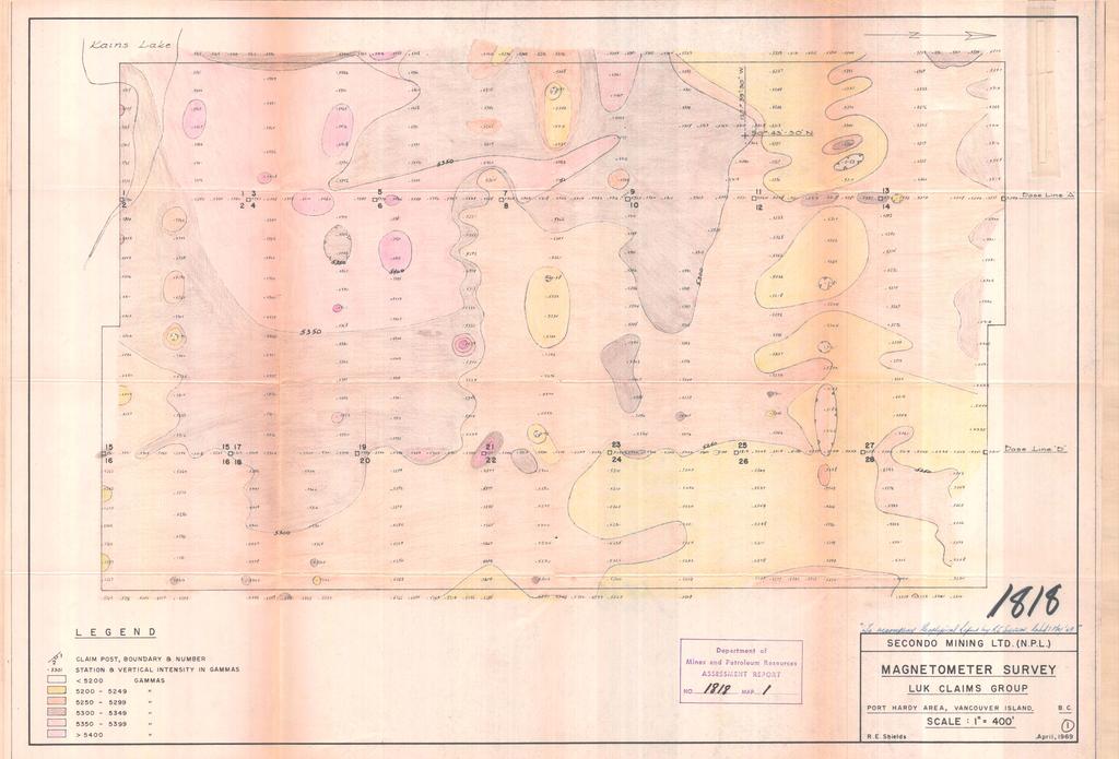
1 GEOPHYSICAL REPORT VERTICAL INTENSITY MAGNETOMEER SURVEY ON LUK CLAIMS, 7 MILES WEST OF PORT HARDY, B.C. 50' 127O SE BY R. E. SHIELDS UNDER SUPERVISION OF J. R. BILLINGSLEY FOR SECOND0 MINING LTD. (N. P.L. ) DURING MARCH 28, 1969 to APRIL 8, a-
2 TABLE OF CONTENTS - Page SUMMARY INTRODUCTION... 2 LOCATION AND ACCESS... 2 GEOLOGY... 2 MAGNETOMETER SURVEY... 3 SURVEY RESULTS... 3 APPENDIX 1 APPENDIX I1 CERTIFICATE ) I Department of Mines and Petroleum Res. AS;E;S, izi:41t REPC NO.... Il/f... MAP... a
3 SUMMARY A reconnaissance magnetometer survey was conducted on the LLIK 1-to 28 claims during March and April, The results revealed low magnetic relief with no encouraging anomalies. a
4 ... 2 INTRODUCTION This report describes the procedures and results of a reconnaissance vertical intensity magnetometer survey carried out for Second0 Mining Ltd. (N.P.L.) on the LUK mineral claims in the Port Hardy area of Vancouver Island. The survey was carried out by the author and one assistant during the period March 28, 1969 to April 8, The object was to detect and map any deviations in the magnetic field over the claims area which might indicate the presence of an intrusive body. Due to deteriorating snow conditions, only the LUK 1 to 28 claims could be surveyed. LOCATION AND ACCESS The LUK claims consist of 48 contiguous mineral claims situated (50 43'N 127O 38'W) 7 miles west of Port Hardy, B.C. Access is by logging road from Port Hardy. See copy of N.T.S. Sheet 92 L accompanying this report. PROPERTY The following constitute the LUK mineral claims: Claim Name Record Numbers LUK # GEOLOGY "he geology as suggested by a 1957 map, published by J. E. Muller from information mapped by G.S.C. and the B.C. Dept. of Mines and Mineral Resources, indicates the claim group is underlain by the Karmutsen Formation of the Vancouver Group. This formation strikes northwest and consists of basic volcanic rocks. Outcrop is less than 5% and where encountered it consisted of fine grained basic lava.
5 ......I3 MAGNETOMETER SURVEY The reconnaissance magnetometer survey was conducted with the possibility that such survey might indicate the presence of any sizeable granitic intrusives which are a possible pre-requisite for ore. The survey was controlled by two north-south baselines surveyed in by compass and chain. Traverses were east-west at 800 foot intervals with readings taken at marked stations every 200 feet. Each traverse was tied into a baseline station to enable diurnal corrections. The vertical magnetic field intensity, in gammas, recorded at each station, is shown on the map accompanying.this report. The survey covers LUK 1-28 claims. The magnetometers used for this survey were Geotronics Model 0100's. SURVEY RESULTS The survey indicates an area of low magnetic relief with 90% of the readings in the gamrange. The general trend of high relief in the southeast, decreasing to lower relief in the northwest, and a northwest lineation suggests that the trend may be due to the strike of the underlying volcanics. The east-west low in the north sector, although possibly valid, is suspect because all readings were taken during one traverse. If valid this linear could suggest a fault. However, an inspection of aerial photographs of the particular area revealed no evidence of faulting. anomalies. In conclusion, the magnetic survey reveals no encouraging
6 ~i APPENDIX I - PERSONNEL The following personnel were employed on the property during the time indicated. Personne 1 Occupation Period Employed Mr. L. Bell, Alberni St., Instrument Operator March 28 - April 8, 1969 Vancouver, B.C. Mr. R. E. Shields, E. Hastings St., Mining Technologist March 28 - April 8, 1969 Burnaby 2, B.C.
7 a APPENDIX I1 The following is a statement of expenditures incurred in the performance of the work described in this report. Wages - 2 men March 28 - April 8 Professional fees, report writing, drafting ' Instrument Rental muck Rental Gas Room and Meals - Seagate Hotel, Port Hardy, March 28 - April 8 Miscellaneous Equipment $ , I hereby swear that the above statement is, to the best of my knowledge, correct. SECOND0 MINING LTD. (N.P.L.) / '?l;a day of Vancouver, British Columbia this -7fl
8 CERTIFICATE I, ROGER E. SHIELDS, hereby certify: 1. THAT I am a Mining Technologist and reside at 5900 East Hastings, Burnaby 2, B.C. 2. THAT I am a graduate of the British Columbia Institute of Technology, May 1968, and have been continuously engaged in my technology since that time. 3. THAT the geophysical aspects' of the foregoing report is based on my personal supervision of the project as described. 4. THAT I do not have, nor do I expect to receive, directly or indirectly, any interest in the properties or securities of Second0 Mining Ltd. (N.P.L.) DATED THIS /' DAY OF APRIL, 1969 IN THE CITY OF VANCOUVER, BRITISH COLUMBIA. / Mining Technologist. a
9

10
I PRELIMINARY MAGNETOMETER SURVEY
 .REPORT O N I PRELIMINARY MAGNETOMETER SURVEY and GEOLOGICAL RECONNAISSANCE L AND K GROUP OF CLAIMS Located 8 Miles East of Princeton, B. C. Similkameen Mining Division Lat. 49' 27' N. Long. 120' 16' W
BALFOUR MINING LTD. (N.P.L.) HAM GROUP 92-P-6, CLINTON M. D.8 B. C. Lat 51 17'N, GEOCHEMICAL REPORT. V. CUKOR, P. Eng.
 HAM GROUP 92-P-6, CLINTON M. D.8 B. C. Lat 51 17'N, GEOCHEMICAL REPORT. V. CUKOR, P. Eng.") 34q '7 BALFOUR MINING LTD. (N.P.L.) HAM GROUP 92-P-6, CLINTON M. D.8 B. C. Lat 51 17'N, Long 12lo14'W GEOCHEMICAL REPORT, V. CUKOR, P. Eng. January 31, 1972 TABLE OF CONTENTS 1. INTRODUCTION 2. PROPERTY,
34q '7 BALFOUR MINING LTD. (N.P.L.) HAM GROUP 92-P-6, CLINTON M. D.8 B. C. Lat 51 17'N, Long 12lo14'W GEOCHEMICAL REPORT, V. CUKOR, P. Eng. January 31, 1972 TABLE OF CONTENTS 1. INTRODUCTION 2. PROPERTY,
1 CLAIMS GEOPHYSICAL REPORT ON BOYAL SITUATE NORTHEAST OF TILLICUM MOUNTAIN GOLD AREA BURTON - NAKUSP SIQCAEJ MINING DIVISION
 GEOPHYSICAL REPORT ON BOYAL 1 CLAIMS SITUATE NORTHEAST OF TILLICUM MOUNTAIN GOLD AREA BURTON - NAKUSP SIQCAEJ MINING DIVISION CONSULTING GEOLOGIST AUGUST 1983 VANCOUVER B *C INDEX INTRODUCTION ooa,.eoaaa.aaaoaaooaoa~ao~o
CONSULTING GEOLOGICAL 8: MINING ENGINEERS STINGS STREET DA V6E 2E9 GEOPHYSICAL SURVEY SILVER QUEEN 2 ZEBALLOS AREA. B.C.
 DOLMAGE CAMPBELL & ASSOCIATES (1 975) LTD. CONSULTING GEOLOGICAL 8: MINING ENGINEERS STINGS STREET DA V6E 2E9 '' 1E O L 0 G I C A.L B'x;&a:f2:#& 'SESSMENT REPObT 12, Assessment RESOURCES LTD. 111 ReDort
PROSPECTING REPORT THE WALLACE CLAIM OMENICA MINING DIVISION. 54" x6" 3.d d. for. Reako Exlorat ions Ltd. Wallace Rev. C.G.
 PROSPECTING REPORT ON THE WALLACE CLAIM OMENICA MINING DIVISION 54"44 14 1x6" 3.d d by David A. Howard P.Eng. for Reako Exlorat ions Ltd. Claim Locat ion Wallace Rev. C.G. #1560 Dome Mountain Area 9 3
NICOLA M.D King Street West, April, 1969 AMALG 1-44 MINERAL CLAIMS 1. OWNER: Dr. F. R. Burton, W. M. Sirola, P. Eng.
 REPORT ON ' MAGNETIC AND ELECTROMAGNETIC SURVEY AMALG 1-44 MINERAL CLAIMS 1. NICOLA M.D. 49'501 N - 12Oo57f W OWNER: Dr. F. R. Burton, 1506-44 King Street West, Toronto 1, Ontario. by W. M. Sirola, P.
J.D. Mason, Prof. Engineer. Report on the Reconnaissance Magnetometer Survey. Completed for. North American Platinum Corporation Ltd.
 Report on the Reconnaissance Magnetometer Survey Completed for North American Platinum Corporation Ltd. Olivine Mountain Property, Tulameen, B.C. J.D. Mason, Prof. Engineer. November 28, 1967. Certificate
COMINCO LTD. HORIZONTAL LOOP EM AND MAGNETIC SURVEYS ON SHA. CLAIMS 1, 2, 7 and 8 NELSON AND FORT STEELE MINING DIVISIONS, B.C.
 COMINCO LTD. EXPLORATION WESTERN DISTRICT NTS: 82-F/1 HORIZONTAL LOOP EM AND MAGNETIC SURVEYS ON SHA CLAIMS 1, 2, 7 and 8 - ASSESSMENT REPORT - NELSON AND FORT STEELE MINING DIVISIONS, B.C. Latitude Longitude
GEOPHYSICAL REPORT. Airborne Magnetometer Survey. of the SHEEP-GOAT GROUP OF MINERAL CLAIMS. near Li l looet, B.C.
 GEOPHYSICAL REPORT 977 Airborne Magnetometer Survey of the SHEEP-GOAT GROUP OF MINERAL CLAIMS near Li l looet, B.C. Lillooet Mining Division (Lat.51 'lot Long. 122 40' 7 5t0[2L05E. for DUFFEY LAKES MINES
'-7' REPORT ON A MAGNETOMETER SURVEY OVER PART OF THE MAX CLAIM GROUP 1-20 LAC LE JEUNE AREA KAMLOOPS MINING DIVISION KAMLOOPS, BRITISH COLUMBIA
 I,., - SUITE 102. 222 BELLEVUE WES t ANCOUVER, B. '-7' REPORT ON A I MAGNETOMETER SURVEY OVER PART OF THE MAX CLAIM GROUP 1-20 LAC LE JEUNE AREA KAMLOOPS MINING DIVISION KAMLOOPS, BRITISH COLUMBIA 50-30
PHOENIX GEOPHYSICS LIMITED REPORT ON THE VLF-EM AND TOTAL FIELD MAGNETOMETER SURVEYS ON THE
 PHOENIX GEOPHYSICS LIMITED REPORT ON THE VLF-EM AND TOTAL FIELD MAGNETOMETER SURVEYS ON THE TAN CLAIMS, CHILLIWACK AREA NEW WESTMINSTER MINING DIVISION, BRITISH COLUMBIA FOR LORNEX MINING CORPORATION LIMITED
PIOTR LUTYNSKI VANCOUVER, BRITISH COLUMBIA
 AN ASSESSMENT REPORT ON GROUND MAGNETIC SURVEYING CHUCHI PROPERTY FORT ST. JAMES AREA, BRITISH COLUMBIA OMINECA M.D. 55 17 N, 124 31 W NTS 93N/ 7&8 Claims Surveyed: 597976, 597878-597880 Survey Dates:
ASSESSMENT REPORT MAGNETOMETER SURVEY GOLDEN ROD, GOLDEN ROD #2. Long.: General Delivery, Vananda, B. C.
 ASSESSMENT REPORT MAGNETOMETER SURVEY GOLDEN ROD, GOLDEN ROD #2 t=/ NTS 92~110w Lat.: Long.: 49O 44' N 124O 34' W Owner: E. Johanson General Delivery, Vananda, B. C. Operator: Rhyolite Resources I nc.
_.----." 2) Gravimetric Profiles... In Pocket TABLE OF CONTENTS PAGE - SUMMARY AN0 CONCLUSIONS... 1A GRAVIMETRIC SURVEY Field Procedures...
 Gravimetric Profiles... In Pocket TABLE OF CONTENTS PAGE - SUMMARY AN0 CONCLUSIONS... 1A GRAVIMETRIC SURVEY Field Procedures...") _.----." TABLE OF CONTENTS PAGE - SUMMARY AN0 CONCLUSIONS... 1A GRAVIMETRIC SURVEY... 1 Field Procedures... 1 Elevation and Horizontal Control... 2 Meter Procedures... 2 Computing Procedures... 2 Plotting...
_.----." TABLE OF CONTENTS PAGE - SUMMARY AN0 CONCLUSIONS... 1A GRAVIMETRIC SURVEY... 1 Field Procedures... 1 Elevation and Horizontal Control... 2 Meter Procedures... 2 Computing Procedures... 2 Plotting...
GEOPHYSICAL REPORT ON AN INDUCED POLAR.IZATION SURVEY
 GEOPHYSICAL REPORT ON AN INDUCED POLAR.IZATION SURVEY T & V Claim Groups some 12 miles Northwest of Babine Lake, B.C. Latitude 55' 26'N Longitude 126' 35'W AUTHOR: Glen E. White, Chief Geophysicist,a,
REPORT ON MAGNETOMETER SURVEY TIK-1 CLAIM e&f KAMLOOPS MINING DTVISION. by D. Hendry D. C. MILLER. February 3, for
 REPORT ON MAGNETOMETER SURVEY TIK-1 CLAIM 92-1-14 e&f KAMLOOPS MINING DTVISION lat. 50 57 ' 12" long. 121O23 ' 37" OWNER: ST. JOSEPH EXPLORATIONS LIMITED OPERATIOR: ST. JOSEPH EXPLORATIONS LIMITED by D.
compietea since tnat date, and wnicn comprisea btage I ot tne recommended
 compietea since tnat date, and wnicn comprisea btage I ot tne recommended four-stage program. GEOLOGY & MINERALIZATION The property situate6 on the southeast slope of Nickel Plate Mtn., and within the
490 20' 30" North Latitude ' 30" West Longitude
 _._.. I CONSULTING GEOLOGISTS 605-602 WEST HASTINGS STREET, VANCOUVER, B.C. V6B 1P2 TELEPHONE: (604) 689-5533 6 I F: ASSESSMENT REPORT ON THE PATSY 1 MINERAL CLAIM ' '?%2% I WHISTLE CREEK, HEDLEY ARE L-l-
Assessment Work Report. on the Geophysical Surveys carried out over the
 Assessment Work Report on the Geophysical Surveys carried out over the PINE GROUP of Mineral Claims 951-J-15-W Lillooet Mining Division Goldbridge, B.C. Long 122 48' Lat. 50 48' by Levon Resources Ltd.
The survey covered claims, in part or in full, DUCKLING 3, 4, 5, 4 fraction, and 5 fraction.
 514 687-6671 XXX- 602 West Hastin~a StroeP, Vata;sn@ouver, BritlsA fhlum~b~a, Garaadsa B81apphgtaa DISCUSS ION OF MAGNETOMETER SURVEY ON DUCKLING CLAIMS FOR DONNA MINES LTD. (N0P.L.) Submitted to: DONNA
UNION MINIERE EXPLORATIONS AND MINING CORPORATION LIMITED ASSESSMENT REPORT ON FITINAT MINERAL CLAIM. Alberni Mining Division Record No.
 M F )( UNION MINIERE EXPLORATIONS AND MINING CORPORATION LIMITED Suite 200, 4299 Canada Way, Burnaby, B.C. V5G 1 H4 Telephone (604) 437-9491 ASSESSMENT REPORT ON GEOCHEMICAL SOIL SURVEYS AND ROCKSAMPLING
t+o...&zz!. ASSESSMENT REPORT Department of Miner and Petroleum Resources MAP.,- INDUCED POLAKIZATION SURVEY OVER THE BROOKS PROSPECT
 5873 INDUCED POLAKIZATION SURVEY OVER THE BROOKS PROSPECT BROOKS PENINSULA AREA VANCOUVER ISLAND, B.C. NANAIMO AND ALBERNI MINING DIVISIONS BY Z. B. DOBORZYNSKI JANUARY, 1976 Department of Miner and Petroleum
A Prospecting Report on the Leo d Or Mineral Claims
 A Prospecting Report on the Leo d Or Mineral Claims Hnvilah Gold Mines Ltd. John Devlin Ande Rychter Leo d Or Claims 2202 C63 NTS, 32 L/7NNippkish 1264 W W, 508) 23$J o f Owner: M.S. Madnri /nay 25, 1987
SUMMl'l WlLS LIU. GEOPHYSICAL REPORT. W. CT. a~evenson Y I
 SUMMl'l WlLS LIU. GEOPHYSICAL REPORT W. CT. a~evenson Y3 qi@, 1970. I 2-90 9 CONTENTS - PAGE Introduction... 1 Property... 1 Location and Access... 1 Survey Specifications Survey Grid... 1 Induced Polarization
I 4.w.g //old. Lat. 5Oo35T Long T. for. By: James R. Glass, P. Eng. June 6, DUSTY MAC MINES LTD. (N.P.L.)
") 440 6 REPORT ON MAGNETOMETER SURVEY POD GROU'OF CLAIMS HIGHLAND VALLEY KAMLOOPS MINING DIVISION Lat. 5Oo35T Long. 120 55T 9.2 1 //old for DUSTY MAC MINES LTD. (N.P.L.) By: James R. Glass, P. Eng. June
440 6 REPORT ON MAGNETOMETER SURVEY POD GROU'OF CLAIMS HIGHLAND VALLEY KAMLOOPS MINING DIVISION Lat. 5Oo35T Long. 120 55T 9.2 1 //old for DUSTY MAC MINES LTD. (N.P.L.) By: James R. Glass, P. Eng. June
GEOPHYSICAL REPORT of the GROUND MAGNETO METER S U RVEY. on the LOC MINERAL CLAIMS SELISH MOUNTAIN AREA, B. C. NICOLA MINING DIVISION
 f -. GEOPHYSICAL REPORT of the GROUND MAGNETO METER S U RVEY on the LOC MINERAL CLAIMS SELISH MOUNTAIN AREA, B. C. NICOLA MINING DIVISION Latitude: 49'49" Longitude: 120'48'W N.T.S. 92H/15 on behalf of
 ..m,"f.k*"--v- A tot,al of 18 line miles of magnetometer surveying was completed on the "B" and "J" claim groups during August of 197. Approximately two-thirds of the area covered by the survey is glaciated,
ASSESSMENT' REPORT GEOPHYSICAL REPORT ON THE ATTORNEY 2 CLAIM (4 UNITS) OMINECA MINING DIVISION SHEILA A. CRAWFORD.
 OMINECA MINING DIVISION SHEILA A. CRAWFORD.") ASSESSMENT' REPORT GEOPHYSICAL REPORT ON THE ATTORNEY 2 CLAIM (4 UNITS) OMINECA MINING DIVISION by SHEILA A. CRAWFORD LOCATION: 57z17' N Latitude 127 11' W Longitude N.T.S. 94E/6E OWNER/OPERATOR: SEREM
ASSESSMENT' REPORT GEOPHYSICAL REPORT ON THE ATTORNEY 2 CLAIM (4 UNITS) OMINECA MINING DIVISION by SHEILA A. CRAWFORD LOCATION: 57z17' N Latitude 127 11' W Longitude N.T.S. 94E/6E OWNER/OPERATOR: SEREM
GEOCHEMICAL REPORT ON A SOIL SAMPLING SURVEY OF PORTIONS OF THE KR GROUP OF MINERAL CLAIMS OF PLATEAU METALS LIMITED.
 GEOCHEMICAL REPORT ON A SOIL SAMPLING SURVEY OF PORTIONS OF THE KR GROUP OF MINERAL CLAIMS OF PLATEAU METALS LIMITED By Kol Lovang Christopher Riley, P. Eng., Supervisor c Vancouver, B. c. Work Performed:
ASSES5dMENT REPORT. Department of. Sept. 15th, Mines and Petroleum Resource.: NO... s?.rk... MAP... I. GEOPHYSICAL mport
 GEOPHYSCAL mport ON THE 92~/2 FOSSELL CmEK GROUP OF COUS CmEK COPPER MNES LTD. AT PORT ALBERN, B. C. BY N.B. VOLLO, P.ENG Sept. 15th, 1976 t Department of Mines and Petroleum Resource.: ASSES5dMENT REPORT
Introducti on. Land Survey. Geomagnetic Survey. Geomagnetic Results and Interpretati ons - Conclusions and Recommendations C
 m M 42A86SW8281 63.42 PRICE 010 C O H T E H l 42A86SW828I 63.42 PRICE 010C Introducti on Land Survey Geomagnetic Survey Geomagnetic Results and Interpretati ons - Conclusions and Recommendations - - -
on the Diamond Drilling done on the LAKESIOE GROUP of Mineral Claims SLOCAN MINING DIVISION 82-F-14-W Long ' Lat '
 Assessment Work Report on the Diamond Drilling done on the LAKESIOE GROUP of Mineral Claims SLOCAN MINING DIVISION 82-F-14-W Long 117 22' Lat. 49 58' ADRIAN KESLER SILVERTON, B.C. operator LEVON RESOURCES
EWS PETROLEUM CORPCWAT~ WEST HASTINGS STREET VANCOUVER, 8. C. V6C 186
 EWS PETROLEUM CORPCWAT~ 613-837 WEST HASTINGS STREET VANCOUVER, 8. C. V6C 186 GEOPHYSICAL REPORT on a VLF - ELECTROkAGNETlC SURVEY on the SHEBA MINERAL CLAIM CARIBOO MINING OIVISION NTS 93 H/3 Lat. 53
RECONNAISSANCE GEOCHEMICAL SURVEY
 RECONNAISSANCE GEOCHEMICAL SURVEY LEGAL, RITA, LOUISE FR. (CHAPLEAU GROUP) REVERTED CROWN GRANTS CHAPLEAU CREEK AREAJ, SLOC& MINING DIVISION 82 F/11W Lat: 49'44" Long: 117"22'W MINERAL RESOURCES BRANCH
TOPOGRAPHICAL SURVEY REPORT ON THE GREENDROP PROPERTY NEAR CHILLIWACK, B.C. 92-H-3/W
 TOPOGRAPHICAL SURVEY REPORT ON THE GREENDROP PROPERTY NEW WESTMINSTER M.D. NEAR CHILLIWACK, B.C. 92-H-3/W Location: The central pap of the claims is located at coordinates 49 08'N, latitude by 121 26'W,
on the SALAL CREEK MOLYBDENUM PROPERTY, SALAL CREEK, B.C. LILLOOET MINING DIVISION, BRITISH COLUMBIA
 on the J PLUG 9-12, PLUG 19-24, BAT 10-14, BAT 15 Fr., BAT 16 Fr. MINERAL CLAIMS, SALAL CREEK MOLYBDENUM PROPERTY, SALAL CREEK, B.C. LILLOOET MINING DIVISION, BRITISH COLUMBIA N.T.S. 92 J 14 LATITUDE 50
GEOPHYSICAL REPORT THE CAVZ CLAIMS
 GEOPHYSICAL REPORT Magnetometer Survey on THE CAVZ CLAIMS CAVZ M.C.'s 1 to 12, 15 to 26, 29 to 40, 45 to 54 Trail Peak, Omineca M.D. 13 miles northeast of Fort Babine 550 ) 126 S.E. by G.Podolsky J.Russell
ASSESSMENT REPORT N 0. REPORT ON HORIZONTAL COPLANAR LOOP ELECTROMAGNETIC SURVEY HOUSTON AREA OF BRITISH COLUMBIA AQUITAINE COMPANY OF CANADA DURING
 tf 62 33 REPORT ON HORIZONTAL COPLANAR LOOP ELECTROMAGNETIC SURVEY IN THE HOUSTON AREA OF BRITISH COLUMBIA BY AQUITAINE COMPANY OF CANADA c DURING MARCH 21 - MARCH 25, 1977 MINERAL RESOURCES BRANCH ASSESSMENT
PHYSICAL WORK REPORT. the BAY CLAIMS. Omineca Mining Division Smithers, British Columbia N.T.S. 93E 13E/W
 PHYSICAL WORK REPORT the BAY CLAIMS Omineca Mining Division Smithers, British Columbia a N.T.S. 93E 13E/W LATITUDE: 53 57 00 N I LONGITUDE: 127 45 OO W for Home Ventures Ltd. 1201-675 West Hastings Street
PROSPECTORS ASSISTANCE PROGRAM MINISTRY OF ENERGY AND MINES
 BRITISH COLUMBIA PROSPECTORS ASSISTANCE PROGRAM MINISTRY OF ENERGY AND MINES GEOLOGICAL SURVEY BRANCH PROGRAM YEAR: 1999/2000 REPORT #: PAP 99-l 6 NAME: KIM ANSCHETZ PROSPECTORS TlEPORT on the 99 LOUIS
1 i I.; :<7 6EOLOGICAL BRANCH ASSESSMENT REPORT HLEM, VLF-EM AND MAGNETOMETER TEST SURVEY ON THE ARC PROPERTY FOR SURVEY BY SJ GEOPHYSICS LTD.
 f - ~ --- j LOG NO: MAR 2 a 1992,,, -- - - - -- L$TiC'P;: I.; 1 i HLEM, VLF-EM AND MAGNETOMETER TEST SURVEY ON THE ARC PROPERTY FOR SURVEY BY SJ GEOPHYSICS LTD. SLOCAN M.D., B.C. N.T.S. 88 F/10 d 2- :
COMINCO LTD. GEOPHYSICAL REPORT ON AN INDUCED POLARIZATION SURVEY RIM PROPERTY RAFT RIVER AREA KAMLOOPS MINING DIVISION,
 COMNCO LTD. EX PLORAT ON WESTERN DSTRCT NTS: 82M/13E 25 JUNE 1981 GEOPHYSCAL REPORT ON AN NDUCED POLARZATON SURVEY RM PROPERTY RAFT RVER AREA KAMLOOPS MNNG DVSON, B.C. LATTUDE: 51'52'N LONGTUDE : 11 9'45
ASSESSMENT REPORT I.P./RESISTIVITY AND MAGNETICS SURVEY ON THE HAUTETE PROPERTY LATITUDE: 55O 12' N LONGITUDE: 126O 07' W
 NTS: 93W1 ASSESSMENT REPORT I.P./RESISTIVITY AND MAGNETICS SURVEY ON THE HAUTETE PROPERTY LATITUDE: 55O 12' N LONGITUDE: 126O 07' W OMINECA MINING DISTRICI'. B.C. CLAIMS COVERED : TET 1-8 TIME PERIOD:
GIANT MASCOT MINES LIMITED ~nen~z~s~11~uumsn~ SURRARD STREET VANCOUVER 1, B. C. June 4, 1968
 NtNI OFFICE; P. 0. BOX 820. HOPE. 8. C. TELEP*ON
for the Greenwood Mining Division, B.C. NTS 82E/7W Latitude 49' 27' W, Longitude 118' 5 Prepared by a= D. Dylan Watt, B.Sc.
 t. b LOGnO: 37~ -08 m. ACTIO#: for the AMP AMP 2 AMP 3 t AMP 4 CLAIMS Greenwood Mining Division, B.C. NTS 82E/7W Latitude 49' 27' W, Longitude 8' 5 %E c,w zc *& a w Prepared by a= -4c. D. Dylan Watt, B.Sc.
HELICOPTER MAGNETIC SURVEY MISINCHINKA RANGE AREA, B.C. ONINECA MINING DIVISION. on behalf of STOKES EXPLORATION MANAGEMENT LTD.
 HELICOPTER MAGNETIC SURVEY MISINCHINKA RANGE AREA, B.C. ONINECA MINING DIVISION on behalf of STOKES EXPLORATION MANAGEMENT LTD. Claims : FALCON $1, FALCON #2 Location: Dated: About 7% kilometers N.E. of
GEOCSZNICAL - SURVEY. ICAMLOOPS Kl.D. 2'' 6;kr. HY "'f. Alfred R. Allen,P.Eng. 1 NO.%=...,... 6"- 'I.
 t i.i GEOCSZNICAL - SURVEY i p' ICAMLOOPS Kl.D. 2'' 6;kr HY 50-64 +."'f 121-51 NE 5-10-70 : 19-10-70 Alfred R. Allen,P.Eng. I) ' 1 6"- 'I. 1 NO.%=...,..... Q.C. EXPLORATIONS LTD. 2Cl- 535 Kowe Street Vancouver
Gold Mountain Group Gold Mtn. A, B, C & D Mineral Claims Record Nos. 697, 698, 699 & 700. Island Mountain Cariboo Mining Division British Columbia
 GOLD POINT RESOURCES LTD. Geophysical Survey Gold Mountain Group Gold Mtn. A, B, C & D Mineral Claims Record Nos. 697, 698, 699 & 700 Island Mountain Cariboo Mining Division British Columbia Vancouver,
REPORT ON A GEOLOGICAL MAPPING AND PROSPECTING PROGRAM LOOK PROPERTY
 b KOKANEE EXPLORATIONS LTDI I WNO. 0 I- n c/ REPORT ON A GEOLOGICAL MAPPING AND PROSPECTING PROGRAM LOOK PROPERTY LOOK 1-31, 36-43 CLAIMS FORT STEELE MINING DIVISION CRANBROOK AREA N.T.S. 82G/5W + 4E E:
Trout Lake Area, British Columbia (500, 50' N., 117O 40' t?) Claims surveyed: WE, VIK. Survey Dates: June 6th - " 12th, 84 FOR
 Claims surveyed: WE, VIK. Survey Dates: June 6th - 12th, 84 FOR") PETER E. WALCOTT Rr ASSOC. LTD. P ~ L C ~ \%%95 GEOLOGICAL BRANCH ASSb:fiSMENT REPOPT A GEOPlIYSICAL REPORT Trout Lake Area, British Columbia (500, 50' N., 117O 40' t?) Claims surveyed: WE, VIK Survey
PETER E. WALCOTT Rr ASSOC. LTD. P ~ L C ~ \%%95 GEOLOGICAL BRANCH ASSb:fiSMENT REPOPT A GEOPlIYSICAL REPORT Trout Lake Area, British Columbia (500, 50' N., 117O 40' t?) Claims surveyed: WE, VIK Survey
Fox 2-Record No. 2524
 F HELICOPTER E.M. AND MAGNETOMETER SURVEY OVER THE FOX CLAIMS, OMINECA MINING DISTRICT BRITISH COLUMBIA ON BEHALF OF OWNER MR. MIKE BOYLE Claims: Fox l-record No. 2523 Fox 2-Record No. 2524 Location 126'
PRECIOUS METALS. owner. JMT Services Corp. GEOCHPlICAL SAMPLING CHELASLIE WCE, NORTH CENTRAL, B.C. OMINECA MINING DIVISION NTS 93F/5E & 6W
 PRECIOUS METALS REPORT ON 1980 RECONNAISSANCE GEOCHPlICAL SAMPLING CHELASLIE WCE, NORTH CENTRAL, B.C. OMINECA MINING DIVISION NTS 93F/5E & 6W LATITUDE 53O28 N LONGITUDE 125O31 W DATES Qp WORK: JULY 10
of Youbou, V.I. on Work Done between Aulqust 10 and November four miles north 4a0w0 NE J.H. Mcmtqomery, Ph.D. P. Enq. GEOCHEMICAL SEPORT
 GEOCHEMCAL SEPORT on Work Done between Aulqust 10 and November 19. 1969, on Anne 23-3Ze 35-40 0.--...-, Mineral,..-... ~. -. -...: ::,;./.,....... ;; ' ',Claims.. owned::by Hlbernla Mlnlnq Co. Ltd.,' '..'
r Department of Mines and P,1Pr2!sum Resources I ... ' AS f 5 5 E t.! T R E p (J RT Mt, Sicker, Duncan Area, Vancouver Island, B.C.
 45- I A REPORT - ON AN ELECTROMAGNETIC SURVEY Mt, Sicker, Duncan Area, Vancouver Island, B.C. DUCANEX RESOURCES LIMITED Vancouver, British Columbia r Department of Mines and P,1Pr2!sum Resources I AS f
Rail Lake Copper Property (WB Claims) G.M. Depaoli, B.Sc. Geophysicist J.F. ALl.an, P.Eng. (B.C.! July 1973
 G.M. Depaoli, B.Sc. Geophysicist J.F. ALl.an, P.Eng. (B.C.! July 1973") 1973 Geophysical Report TITLE AUTHORS DATE, COI"4ODITY LOCATION-A rea -Mining Division -Coordinates -NTS Rail Lake Copper Property (WB Claims) GM Depaoli, BSc Geophysicist JF ALlan, PEng (BC! July 1973
1973 Geophysical Report TITLE AUTHORS DATE, COI"4ODITY LOCATION-A rea -Mining Division -Coordinates -NTS Rail Lake Copper Property (WB Claims) GM Depaoli, BSc Geophysicist JF ALlan, PEng (BC! July 1973
Canadian National Railways tracks from the foot bridge across the. Thompson River from the Trans Canada Highway. A pick-up truck was used
 Canadian National Railways tracks from the foot bridge across the Thompson River from the Trans Canada Highway. A pick-up truck was used on the highway side and a h-wheel drive Jeep was transported by
GEOPHYSICAL REPORT ON THE PRINCE GEORGE PORPHYRY PROJECT LYNX PROPERTY
 GEOPHYSICAL REPORT ON THE PRINCE GEORGE PORPHYRY PROJECT LYNX PROPERTY Lynx Property Omenica Mining Division British Columbia Tenure # 841107, 742942, 741962 NTS Sheet 093K MTO Event Number - 5434711 UTM
A REPORT. Bear Lake, British Columbia (56' 13'N, ~) N.T.S. 94 D U& Claims surveyed: BL 1, units 2
 N.T.S. 94 D U& Claims surveyed: BL 1, units 2") I PETER E. WALCOTl' Rr ASSOC. LTD. A REPORT AN INDUCED POLARIZATION SURVEY T.?. d." Bear Lake, British Columbia rnk (56' 13'N, 1270 49~) N.T.S. 94 D U& *o Claims surveyed: BL 1, units 2 *a* & 3 BL 2, units
I PETER E. WALCOTl' Rr ASSOC. LTD. A REPORT AN INDUCED POLARIZATION SURVEY T.?. d." Bear Lake, British Columbia rnk (56' 13'N, 1270 49~) N.T.S. 94 D U& *o Claims surveyed: BL 1, units 2 *a* & 3 BL 2, units
VLF and GRADIOMETER SURVEY OVER THE CAT GROUP, INVERMERE AREA GOLDEN MINING DIVISION, BRITISH COLUMBIA NTS 82K/O8W LAT/LONG 50 29' ' FOR
 VLF and GRADIOMETER SURVEY OVER THE CAT GROUP, INVERMERE AREA GOLDEN MINING DIVISION, BRITISH COLUMBIA NTS 82K/O8W LAT/LONG 50 29' - 116 15' FOR W. POCHYLKO STETTLER, ALBERTA BY T.R.B. DUNDAS ISOGEOS EXPLORATION
SELF POTENTIAL SURVEY OVER THE JAY GROUP, INVERMERE AREA GOLDEN MINING DIVISION, BFUTISH COLUMBIA NTS 82W8W7 82W9W LATLONG 50 30' ' FOR
 - GEOLOGICAL SURVEY BRANCH ASSESSMENT REPORTS -- -- DATE RECEI?/::D 06T 10 1996 - SELF POTENTIAL SURVEY OVER THE JAY GROUP, INVERMERE AREA GOLDEN MINING DIVISION, BFUTISH COLUMBIA NTS 82W8W7 82W9W LATLONG
REPORT. on the. Omineca Mining Division, British Columbia. Latitude N., Longitude W. NTS map sheet 93F/7E. James W. McLeod, P.Geo.
 REPORT on the CHU MOLYBDENUM PROPERTY Omineca Mining Division, British Columbia Latitude 53 21 N., Longitude 124 37 W. NTS map sheet 93F/7E James W. McLeod, P.Geo. on behalf of Mr. Chris Delorme TABLE
Geo chemi c a1 Rep or t SILVER KING FAST GROUP. H. S. Lazenby Geologist. Vancouver, B.C. 16 November 1967
 Geo chemi c a1 Rep or t on SILVER KING FAST GROUP 1967 Vancouver, B.C. 16 November 1967 H. S. Lazenby Geologist Contents Introduction P. 1 Method of Survey P. 1 Interpretation of Results p. L&2 Statement
GROUND GEOPHYSICAL SURVEYS Magnetometer and Horizontal Loop EM. KoKoKo Project Ferrim Lake and Tasse Lake Grids. PANTHEON VENTURES LTD.
 NTS 31 M/4 GROUND GEOPHYSCAL SURVEYS Magnetometer and Horizontal Loop EM KoKoKo Project Ferrim Lake and Tasse Lake Grids PANTHEON VENTURES LTD. September 2007,..-- :. 57 RECEVED JAN 16 ~'2:n GEOSCENCf
3 I1 I I Ill 111 II! II 111 II Ill I IlE I I P I
 -7 3 1 1 11111111111111111111111111111111 ll 111! 111 111 111 111 111111111111111 ll 1111111 1 11111111111111 le P GEOCHEMCAL SURVEY OF THE KE AND D'ARCY CLAM GROUPS.. Similkameen Mining Division, B.C.
GEOLOGICAL BRANCH ASSESSMENT REPORT 12. FItE NO: ACTION: THE GOLDEN MINING DIVISION, GOLDEN, Including THE NTS MAP; M82K/15W
 ACTION: FItE NO: Including 1990 GEO-CHEM SURVEY RESULTS -- THE AVD CLAIMS - THE GOLDEN MINING DIVISION, GOLDEN, B.C. NTS MAP; M82K/15W Lat. 50 deg. 55 Min. Long 116 deg. 55 min. For GEOLOGICAL BRANCH ASSESSMENT
GEOPHYSICAL SURVEY WHITEY AND H GROUP MINERAL CLAIMS KEEN CREEK AREA, SLOCAN MINING DIVISION ANDEX MINES LTD. VANCOWER, B.C.
 R E P O R T ON THE GEOPHYSICAL SURVEY WHITEY AND H GROUP MINERAL CLAIMS KEEN CREEK AREA, B.C. SLOCAN MINING DIVISION ANDEX MINES LTD. VANCOWER, B.C. Andex Mines Ltd., 315-543 Granville Street, Vancouver,
- LONGITUDE : 128'06 'W
 COMINCO LTD. WESTERN DISTRICT MARCH 1977 SOIL GEOCHEMICAL SURVEY SAND 1 and SAND 2 CLAIMS HIDDEN VALLEY AREA LIARD MINING DIVISION LATITUDE : 59'03' - LONGITUDE : 128'06 'W JUNE 20/76-JULY 12/76 REPORT
B.C. Vancouver, Sritish Columbia. Ragas Claims, Omenica M.D., A GEOPHYSICAL REPORT. A GROUKD NAGMETIC 6: ELECTRO?.IAGr\TETIC SURVEY FOR
 A GEOPHYSICAL REPORT A GROUKD NAGMETIC 6: ELECTRO?.IAGr\TETIC SURVEY Ragas Claims, Omenica M.D., B.C. FOR CATRE - 3EK JOINT VENTURE PETER E. WALCOTT & ASSOC. LIPIITED Vancouver, Sritish Columbia OCTOEEEt
..!I AXE CLAIMS ON THE. for RICHCORE EXPLORATIONS LTO. GREENWOOD MINING DIVISION BRITISH COLUMBIA. Latitude 49O 30"; Longitude 118' 30'W NTS 82E/9W
 ON THE AXE CLAIMS for RICHCORE EXPLORATIONS LTO. GREENWOOD MINING DIVISION BRITISH COLUMBIA Latitude 49O 30"; Longitude 118' 30'W NTS 82E/9W... -... ~ i.,...._.'..!i Vancouver, B.C. September, 1980 P.
ASSESSMENT REPORT ON THE VLF-EM SURVEY. Trail Creek Mining Division NTS: 82 F/4 W Longitude: 1 17' 49' 50" Latitude: 49O 03' 40"
 ASSESSMENT REPORT ON THE JERO 5 MINERAL CLAIM ROSSLAND, BRJTISH COLUMBIA VLF-EM SURVEY Trail Creek Mining Division NTS: 82 F/4 W Longitude: 1 17' 49' 50" Latitude: 49O 03' 40" Owner: Operator: Author:
REPORT ON THE MAGNETOMETER SURVEYOF THE SO0 MINERAL CLAIMS MERRITT, B. C.
 336 REPORT ON THE MAGNETOMETER SURVEYOF THE SO0 MINERAL CLAIMS MERRITT, B. C. To: The Directore Copper Soo Mining Syndicate OSO~OOS, B. C. R. C. Clough hglneering Ltd. Harvey H. Cohen, P. Pmg. TABLE OF
Daiwan Engineering Ltd Granville strees V.ncouver, B. C. cuudr WY 1GS. M e : (604) PROSPECTING REPORT ON THE KING MINERAL CLAIMS
 PROSPECTING REPORT ON THE KING MINERAL CLAIMS") 1030-609 Granville strees V.ncouver, B. C. cuudr WY 1GS M e : (604) 688-1508 PROSPECTING REPORT ON THE KING MINERAL CLAIMS NORTH VANCOUVER ISLAND, BRITISH COLUMBIA NTS: 92Lj13E Latitude: 50" 47' Longitude:
1030-609 Granville strees V.ncouver, B. C. cuudr WY 1GS M e : (604) 688-1508 PROSPECTING REPORT ON THE KING MINERAL CLAIMS NORTH VANCOUVER ISLAND, BRITISH COLUMBIA NTS: 92Lj13E Latitude: 50" 47' Longitude:
INDUCED POLARIZATION AND MAGNETOMETER SURVEYS GREENWOOD AREA, BRITISH COLUMBIA ON BEHALF OF GREYHOUND MINES LIMITED. Jon G. Baird, B.Sc.
 ~ C, )... ~, ~ ~..., < MAP.,,... REPORT ON NDUCED POLARZATON AND MAGNETOMETER SURVEYS GREENWOOD AREA, BRTSH COLUMBA ON BEHALF OF GREYHOUND MNES LMTED by i Jon G. Baird, B.Sc., P.Eng., October 5, 1970 LOCATON
NO. MAP..._._..._...,,..,.
 KERR- ADDISON GOLD MINES LIMITED SELF-POTENTIAL SURVEY OWL!i- 12 1 Dwner ) NAOINA 1-4 ) MINERAL CLAIMS W. F. McGowan, ) 3262 Marine Orive, ANGUS 1-4 ) west Vancouver, 8. c. LOCATED AT 5. E. ENO OF OWEN
sq N & %%.& GEOPHYSICAL CONSULTING rr SERVICES LTD. $%& Long. 118o3OtW N.T.S. 82 E/15 -I- AUTROR: Glen E. Whi*e, B.Sc., P. %g.
 -\ GEOCHEMICAL EXPORT.,~.,~..'.. AMORE MINERALS 1NCORPOR;ITZC,' ~. 3rd fl5 Geo 3. and 2 mineral claims, Vernon- ~ $lining Division, B. C. Lat. 49 47'T?,,/ Long. 118o3OtW N.T.S. 82 E/15 -I- AUTROR: Glen
Lat. 52' 43' N Long ' W
 &A exploration ltd MINING ENGINEERING GEOLOGY- GEOPHYSICS 4570 HOSKINS ROAD, NORTH VANCOUVER, 6. C. TELEPHONE (804) 985,7921 V7K 2R1 GEOLOGICAL AND GEOCHEMICAL REPORT on the BLUE CLAIMS Cariboo Mining
2013 GEOLOGICAL ASSESSMENT REPORT SHERIDAN HILL PROPERTY
 2013 GEOLOGICAL ASSESSMENT REPORT ON THE SHERIDAN HILL PROPERTY NEW WESTMINSTER MINING DIVISION BRITISH COLUMBIA NTS 092G07 49 16 31 NORTH LATITUDE, 122 39 48 WEST LONGITUDE PREPARED FOR Sheridan Hill
A Report on a Magnetometer Survey. Division, British Columbia. Gypsy 1-32 and Gypsy 1 Fr-9 Fr. 27 miles north of Smithers
 - A Report on a Magnetometer Survey on the Gypsy Claims, Omineca Mining Division, British Columbia Covering: Gypsy 1-32 and Gypsy 1 Fr-9 Fr Located: 27 miles north of Smithers Latitude 55O11' N Longitude
R.A. COMINCO LTD. EXPLORATION NTS: 92H/16. WESTERN DISTRICT January 6, 1982 ASSESSMENT REPORT 1981 SOIL GEOCHEMISTRY ON THE TROUT PROPERTY
 COMINCO LTD. EXPLORATION NTS: 92H/16 WESTERN DISTRICT January 6, 1982 ASSESSMENT REPORT 1981 SOIL GEOCHEMISTRY ON THE TROUT PROPERTY (Trout 1 and 6 Claims) SIWASH LAKE AREA, SIMILKAMEEN M.D., B.C. (Work
SUPPLEMENT TO MAGNETOMETER 6 ELECTROMAGNETIC SURVEY REPORT. DATED NOVEMBER l, 1973 CIGLEN INVESTMENTS LIMITED CLAIMS GROUP BAD VERMILLION LAKE AREA
 ^ A R l ^ 1974 010 PROJECTS UNIT SUPPLEMENT TO MAGNETOMETER 6 ELECTROMAGNETIC SURVEY REPORT DATED NOVEMBER l, 1973 CIGLEN INVESTMENTS LIMITED CLAIMS GROUP BAD VERMILLION LAKE AREA DISTRICT OF RAINY RIVER
S 7 P #. Y.lC-4y5Y/ GEOPHYSICAL REPORT. Doe. Dill. Daf and Po mineral claims. DATE OF WORK: Narch 1-21, 1978 DATE OF WPOHT: April 21, 1978
 r GEOPHYSICAL REPORT S 7 P #. Y.lC-4y5Y/ Doe. Dill. Daf and Po mineral claims ~~ Grandforks area, Greenwood I\?ining Division Lat. 49 03t30'tN Long. 118 24t'd N.T.S. 82 E/l AUTHOR: Glen E. White, B.Sc.,
--_- A GEOPHYSICAL REPORT AN INDUCED POLARIZATION-SURVEY EQUITY SILVER MINES LIMITED_. John Wesley Ma11 Daniel Morice Merkley Gloria May Merkley
 --_- PETER E. WALCOTI' & ASSOC. LTD. A GEOPHYSICAL REPORT ON AN INDUCED POLARIZATION-SURVEY Houston Area, British Columbia 54O 27'N, 126" 39'W N.T.S. 93L/7E Claims sur-ed: HD 3 & 4 Survey Dates: Sept 16th
We are committed to providing accessible customer service. If you need accessible formats or communications supports, please contact us.
 We are committed to providing accessible customer service. If you need accessible formats or communications supports, please contact us. Nous tenons à améliorer l accessibilité des services à la clientèle.
TABLE OF CONTENTS. Tntroduction Location. Property Location Map -fl' Claim Map & Y% Gso1oe;ical Summary. Method of Survey. Geo10,oical *
 TABLE OF CONTENTS Tntroduction Location Property Location Map -fl' Claim Map & Y% Gso1oe;ical Summary Method of Survey Geo10,oical Map @ *
May 5th - July llth, 1972
 May 5th - July llth, 1972 Wendy Claims Logan Lake Area, Kamloops M.D., B.C. Including Allan 2Afr, 2Bfr, 4, 6, and 8 Wendy 23-28 (incl,) Wendy 30, 31, 32, 33fr, and 34 C opper 7 f r. Located 2 miles west
REPORT OF WORK GEOPHYSICRL SURVEYS ON THE HENK MINERRL CLRIM N. T. S. 93L/2,3 ( ', 54 85' ) Omineca Mining Division
 Omineca Mining Division") REPORT OF WORK GEOPHYSICRL SURVEYS ON THE HENK MINERRL CLRIM N. T. S. 93L/2,3 ( 126 49', 54 85' ) Omineca Mining Division 1 L/$\ GEOLOGICAId BRANCH ASSESSMENT BEPORT -- Submitted by : L. Eradish Division
REPORT OF WORK GEOPHYSICRL SURVEYS ON THE HENK MINERRL CLRIM N. T. S. 93L/2,3 ( 126 49', 54 85' ) Omineca Mining Division 1 L/$\ GEOLOGICAId BRANCH ASSESSMENT BEPORT -- Submitted by : L. Eradish Division
-KERR-ADDISON GOLD MINES LTD. 6EOPHYSICAL & GEOCHEMICAL INVESTIGATION. Of 24 CLAIMS Of THE FAULT GROUP OF MINERAL CLAIMS
 -KERR-ADDISON GOLD MINES LTD. 6EOPHYSICAL & GEOCHEMICAL INVESTIGATION Of 24 CLAIMS Of THE FAULT GROUP OF MINERAL CLAIMS Located About 3 Miles West Of Merritt, B.C. In Nicola M.D. 50 N - 120 w BY W. M.
ASSESSMENT REPORT ON THE PEAVINE PROJECT. DGW & Associates # Alberni Street, Vancouver, British Columbia, V6E 4V2
 ASSESSMENT REPORT ON THE PEAVINE PROJECT KAMLOOPS MINING DIVISION BRITISH COLUMBIA NTS 082M 12 Latitude 51 36' 19.0"North -- Longitude --119 47' 27.0"West UTM Zone 11, NAD 83 5720827N 306744E Prepared
RECEIVED. tn r-"t."' Magnetometer and VLF-EM Surveys Assessment Report. South Cobalt Silver Project South Lorrain Twp. Mhakari Gold Corp.
 RECEVED APR 1 5 111 OOSC!C! AESSMET tn r-"t. Magnetometer and VLF-EM Surveys Assessment Report South Cobalt Silver Project South Lorrain Twp. Mhakari Gold Corp. March 211 TS 31 M/3-4 Meegwich Consultants
B. M. WLSON, P.ENG. FOR CUMONT MINES LIMITED ( N.P.L.)
") RFpoF3 COVERING M&GiTETOMEX'ER AND GEOCREMICAL SURvaYS ON TI-IE BEM GROUP MINERAL CL5IMS PRINCEL'ON, B.C. SIMILlWi4EtEN MINING~DIVISION 49 DEGm - 120 DEGREBS S.E. + SLJ BY B. M. WLSON, P.ENG. FOR CUMONT
RFpoF3 COVERING M&GiTETOMEX'ER AND GEOCREMICAL SURvaYS ON TI-IE BEM GROUP MINERAL CL5IMS PRINCEL'ON, B.C. SIMILlWi4EtEN MINING~DIVISION 49 DEGm - 120 DEGREBS S.E. + SLJ BY B. M. WLSON, P.ENG. FOR CUMONT
Summary of Rover Metals Geologic Mapping Program at the Up Town Gold Project, Northwest Territories
 October 13, 2017 Summary of Rover Metals Geologic Mapping Program at the Up Town Gold Project, Northwest Territories Vancouver, British Columbia, Canada - Rover Metals Corp., Rover, is pleased to provide
MERCURY EXPLORATIONS LIMITED. (N.P.L.) INDUCED POLARIZATION GEOPHYSICAL SURVEY ON THE SITUATED FIFTEEN MILES NORTHWEST N.T.S. 921/7W IN THE PERIOD
 INDUCED POLARIZATION GEOPHYSICAL SURVEY ON THE SITUATED FIFTEEN MILES NORTHWEST N.T.S. 921/7W IN THE PERIOD") MERCURY EXPLORATIONS LIMITED. (N.P.L.) INDUCED POLARIZATION GEOPHYSICAL SURVEY ON THE SPA, SKU, ALTA, SCAT, JEFF, & LARK CLAIMS SITUATED FIFTEEN MILES NORTHWEST OF MERRITT IN THE KAMLOOPS M.D., 50'N. 120"W.
MERCURY EXPLORATIONS LIMITED. (N.P.L.) INDUCED POLARIZATION GEOPHYSICAL SURVEY ON THE SPA, SKU, ALTA, SCAT, JEFF, & LARK CLAIMS SITUATED FIFTEEN MILES NORTHWEST OF MERRITT IN THE KAMLOOPS M.D., 50'N. 120"W.
NTS 93L/9W GEOCHEMICAL AND GEOPHYSICAL REPORT MONA CLAIM OMINICA MINING DIVISION. Lati tude 54036'N; Longitude 'W
 GEOCHEMICAL AND GEOPHYSICAL REPORT ON MONA CLAIM OMINICA MINING DIVISION Lati tude 54036'N; Longitude 126018'W NTS 93L/9W April 1981 Paul Plicka Consulting Geologist LOCATION MAP INTRODUCTION TABLE OF
Toronto, Ontario November 16, This report may not be reproduced, in whole or in part, without the written permission of Derry, Michener S Booth.
 13 2.1354 L ITTLE 010 GEOPHYSICAL SURVEYS, LITTLE TOWNSHIP CLAIM GROUP OB-F TIMMINS AREA PORCUPINE MINING DIVISION, ONTARIO Toronto, Ontario November 16, 1973 This report may not be reproduced, in whole
GEOPHYSICAL REPORT INDUCED POLARIZATION/RESISTMTY SURVEYS. on behalf of TEESHIN REOURCES LTD Argus Road. Oakville, Ontario L6J 354
 GEOPHYSICAL REPORT INDUCED POLARIZATION/RESISTMTY SURVEYS DOME MOUNTAIN PROPERTY, SMITHERS AREA CHRIS, APRIL 1, APRIL 2, APRIL 3, AND MAG 1 CLAIMS CMINECA MINING DMSION, BRITISH COLUMBIA Latitude: 546
51 46'N Latitude, 119'44'1;!
 COMI)!CO LTD. EXPLORATION NTS: 82 1'1/13E GEOCHEKICAL ASSESSMENT REPORT ON THE SI 1 MINERAL CLAIM in the Kamloops Mining Division 51 46'N Latitude, 119'44'1;! Longitude Work Period: June 25, 1979 - July
... corrcluslons... 4 OF CONTENTS FOLD R AT M.CK OF REPORT. 1 Pl.AM*VlEW - APPARENT REStSTlVITY
 ;c ' t,..' A0,! 3-41 NO TA)tE OF CONTENTS... HSTORY... 2 PROCEDURE FOR NDUCED POLARZATON RECOW1 SSANCE SURVEY...*...~..~... 3 RESULTS. 0 0 1 0 rn. 0. 0 0 4 corrcluslons... 4 RECOMMENDATlOMS... 4 COSTS
for the Greenwood Mining Division, B.C. NTS 82E/7W 29' W, Longitude 118' 53' N Prepared by D. Dylan Watt, B.Sc.
 for the FltE NO: u VOLT 1, VOLT 2, VOLT 3, & VOLT 4 CLAIMS Greenwood Mining Division, B.C. NTS 82E/7W Latitude 49' 29' W, Longitude 118' 53' N Prepared by D. Dylan Watt, B.Sc. #309-1996 Trutch Street Vancouver,
PERCY CONTRACTING SERVICES LTD.
 GEOLOGICAL REPORT ON TEN PLACER LEASES (3139, 3140, 3141, 3142, 3143, 3144, 3145, 3146, 3147, 3148) MOREHEAD CREEK CARIB00 MINING DIVISION, B.C. 938/12W (52 38 N, 121 47 W) For PERCY CONTRACTING SERVICES
GEOLOGICAL REPORT and MAGNETOMETER SURVEY 1-34 December 1 to.3, 1973 SIMILKAMEEN MINING DIVISION 'W, 49O 36'N.
 4 03' GEOLOGICAL REPORT and MAGNETOMETER SURVEY on @CLAIMS 1-34 December 1 to.3, 1973 SIMILKAMEEN MINING DIVISION 120 21'W, 49O 36'N w f Cepartmcnt of Mines 22.2 Pe>rsi-.um Resources I.., A43~J~lr,~r.'F