GEOPHYSICAL REPORT ON THE PRINCE GEORGE PORPHYRY PROJECT LYNX PROPERTY
|
|
|
- Bethany Harper
- 5 years ago
- Views:
Transcription
1 GEOPHYSICAL REPORT ON THE PRINCE GEORGE PORPHYRY PROJECT LYNX PROPERTY Lynx Property Omenica Mining Division British Columbia Tenure # , , NTS Sheet 093K MTO Event Number UTM NAD 83 Zone E, N (Centre) XSTRATA CANADA CORPORATION By Troy Miller and Gordon Maxwell April 9 th, 2013
2 TABLE OF CONTENTS 1.0 INTRODUCTION REGIONAL GEOLOGY PROPERTY DESCRIPTION AND LOCATION HISTORY Ground Magnetic Survey STATEMENT OF COSTS RECOMMENDATIONS AND CONCLUSIONS REFERENCES STATEMENT OF QUALIFICATIONS... 7 LIST OF FIGURES Figure 1 - Regional location and access of Lynx property... 3 Figure 2 - Mineral tenure location for Lynx property... 4 Figure 3 - Target of Lynx property ground magnetic survey... 6 LIST OF TABLES Table 1 - Mineral tenure details for Lynx property... 2 Table 2 - Historic work completed on Lynx property... 5 LIST OF APPENDICES Appendix A Geophysical Reports Appendix B Statement of Expenditures 1

3 1.0 INTRODUCTION The Lynx property is one of several properties in the Fort St James area belonging to Xstrata Copper Canada s (XCC) Prince George Porphyry Project focused on the discovery of a large Cu-Au porphyry deposit in the Quesnel Terrane of central British Columbia. The Lynx property was one of five properties that were part of an option agreement between XCC and Uwe Schmidt. This report summarizes the ground based magnetic geophysical survey program completed between February 13 th and 16 th, 2013 which consisted of 12.3 line kilometers over 10 lines on the Lynx property. 2.0 REGIONAL GEOLOGY The Quesnel Terrane is an accreted arc Terrane lining the eastern margin of the Intermontane Belt at its tectonic boundary with the Omineca Belt. The Quesnel Terrane formed in an island arc setting outboard to the ancestral North American continental margin in the Early Jurassic (Panteleyev et al., 1996). Early Mesozoic, alkaline and calc-alkaline island arc magmatism generated many porphyry copper deposits including: Mount Milligan, Mouse Mountain, Mont Polley, Copper Mountain, etc. The Quesnel Terrane near Prince George is fault-bounded to the east by Late Paleozoic meta-sedimentary (volcanic and plutonic) oceanic rocks of the Slide Mountain Accreted Complex and the Cache Creek Accreted Complex to the west (forearc). This is most likely due to the southern extension of the Pinchi fault system (Bailey, 1988). In the Prince George region, the Quesnel Terrane is composed of Takla Group and/or Nicola group Mesozoic strata consisting of fine clastic sediments overlain by a thick sequence of Late Triassic alkaline volcanic and volcaniclastic rocks. Alkaline and calc-alkaline intrusions are sourced from magmatism in the Early Jurassic, Middle Jurassic and Mid-Cretaceous. 3.0 PROPERTY DESCRIPTION AND LOCATION Lynx property is located in central British Columbia, approximately 47 kilometers north of the town of Fort St James. The property covers an area of hectares within the Omineca Mining Division. It is centered at north latitude and west longitude within the limits of NTS sheets 93K/16. Lynx consists of three contiguous mineral tenures. The Lynx property is part of an option agreement between Uwe Schmidt and Xstrata Copper. At this stage in the option agreement, the tenures are being operated by Xstrata and have been transferred into Xstrata s name in trust of the agreement. A regional property location map and a claim tenure map are provided below in Figures 2 and 3. Table 1 lists the mineral tenures included in the Lynx property. Table 1 - Mineral tenure details for Lynx property 2

4 Figure 1 - Regional location and access of Lynx property 3

5 Figure 2 - Mineral tenure location for Lynx property 4
6 4.0 HISTORY Historical work was completed on the Lynx property in 1992 by Rio Algom Exploration Inc. This work includes six IP lines that outlined a broad anomaly and was followed up with four drill holes totaling approximately 384 meters. Refer to Table 4.1 for a summary of historical work. Regional geochemical surveys (rock, soil, stream, lake, etc) and geophysical surveys have also been carried out in this area as part of the QuestBC geosciences initiative. Table 2 - Historic work completed on Lynx property 5.0 Ground Magnetic Survey The ground based magnetic survey was conducted by Peter E. Walcott & Associates and consisted of 10 lines for approximately 12.3 line kilometers. The targeted of the survey was to further define the nature and any smaller scale targets in the magnetic intrusive unit identified in a Figure 3. The location of the lines, survey specifications, data processing, discussion and display of the results are located in completed is detailed in the report from Peter E. Walcott & Associates located in Appendix A. 6.0 STATEMENT OF COSTS A total cost of $ was incurred to conducted and report this program. Details of expenditures are in Appendix B. 7.0 RECOMMENDATIONS AND CONCLUSIONS The survey identified a central relative magnetic high zone approximately 400m by 400 m within the anomaly targeted magnetic anomaly. Due to the size of the anomaly the follow up work recommended is to map the area that coincides with the anomaly and to complete a compilation of interpretation of historical data relevant to the Lynx property. Due to the size of the anomaly it no longer falls within the scope of the XCC exploration program and no further work is planned. 8.0 REFERENCES Bailey, D.G (1988): Geology of the central Quesnel belt, Swift River, south-central British Columbia (93B/16, 93A/12, 93G/1); in Geological Fieldwork 2005, BC Ministry of Energy, Mines and Petroleum Resources, Paper , pages Panteleyev, A., Bailey, D.G., Bloodgood, M.A. and Hancock, K.D. (1996): Geology and mineral deposits of the Quesnel River Horsefly map area, central Quesnel Trough, British Columbia; BC Ministry of Energy, Mines and Petroleum Resources, Bulletin 97, 156 pages. 5

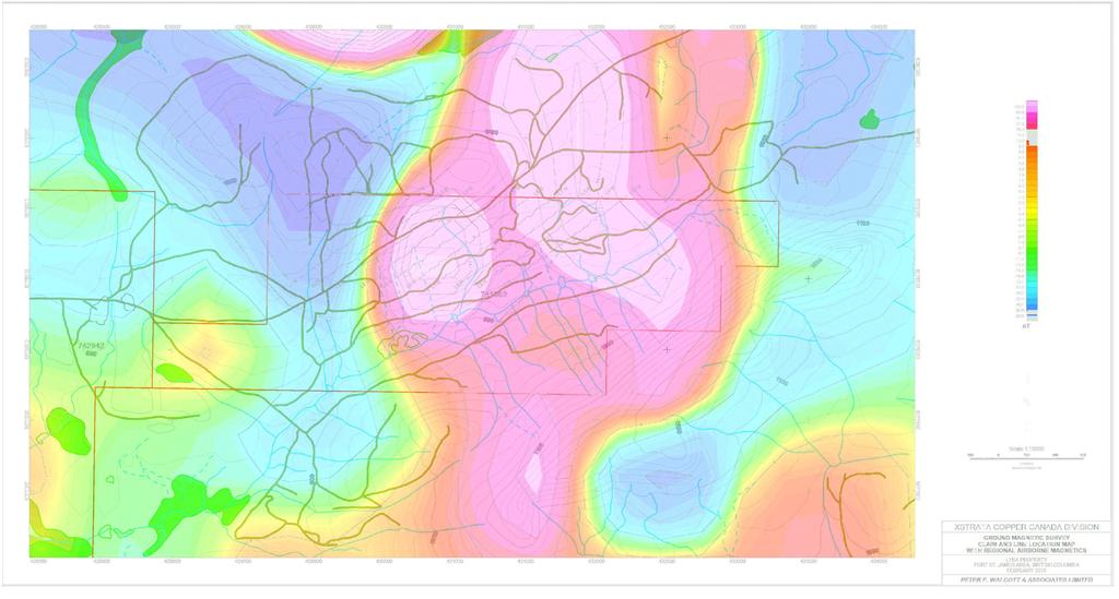
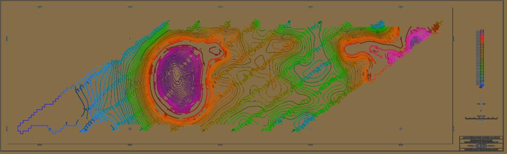
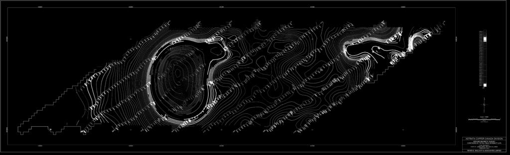
7 Figure 3 - Target of Lynx property ground magnetic survey 6
8 9.0 STATEMENT OF QUALIFICATIONS 4. Dated at Timmins, ON April 9 th, 2013 Gordon Maxwell Exploration Manager Xstrata Canada Corporation 7
9 Appendix A Geophysical Report
10 AN ASSESSMENT REPORT ON GROUND MAGNETIC SURVEYING LYNX PROPERTY FORT ST. JAMES AREA, BRITISH COLUMBIA OMINECA M.D N, W NTS 93 K/16 Claims Surveyed: Survey Dates: February 13 th 16 th, 2013 FOR XSTRATA COPPER CANADA DIVISION Timmins, Ontario BY PETER E. WALCOTT & ASSOCIATES LIMITED Coquitlam, British Columbia APRIL 2013 APPENDIX A OF MAIN ASSESSMENT REPORT BY XSTRATA
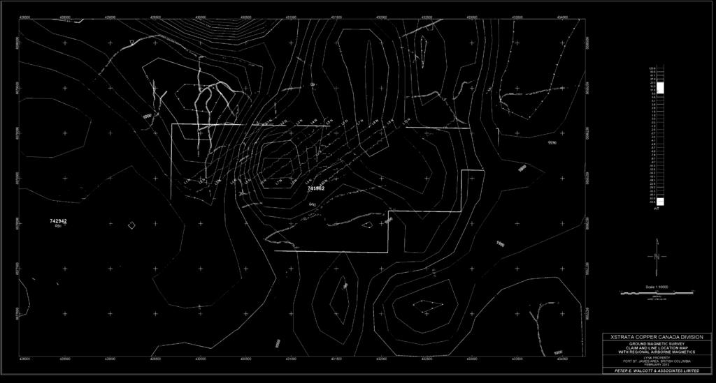
11 2 TABLE OF CONTENTS Page INTRODUCTION.. 3 PROPERTY, LOCATION AND ACCESS... 4 PURPOSE.. 7 SURVEY SPECIFICATIONS.. 8 DISCUSSION OF RESULTS 9 SUMMARY, CONCLUSIONS & RECOMMENDATIONS 10 APPENDIX I Cost of Survey Personnel Employed on Survey Certification ACCOMPANYING MAPS Claim and Line Location Map Scale 1:10,000 Line Location Map with Airborne Magnetics Scale 1:10,000 Contour of Total Field Intensity Scale 1: 2,000 Peter E. Walcott & Associates Limited Geophysical Services 2013 Magnetic Surveying Lynx Property, B.C.
12 3 INTRODUCTION. Between February 13 th and 16 th, 2013, Peter E. Walcott & Associates Limited undertook 12.3 kilometres of magnetic surveying over part of Lynx Property, located in the Fort St. James area of British Columbia, for Xstrata Copper Canada. The surveying was carried out over 10 lines, orientated in a northeasterlydirection, proximal to the Lynx showing. Measurements were made a one second interval utilizing GSM-19W GPS walking magnetometers. Peter E. Walcott & Associates Limited Geophysical Services 2013 Magnetic Surveying Lynx Property, B.C.

13 4 PROPERTY LOCATION AND ACCESS The Lynx property is located some 57 kilometres north of the community of Ft. St. James, British Columbia. Access to the property was obtained via the Germansen Road from Ft. St James, and then via the Germansen-Cripple FSR. Property Location Map Peter E. Walcott & Associates Limited Geophysical Services 2013 Magnetic Surveying Lynx Property, B.C.

14 5 PROPERTY LOCATION AND ACCESS con t Claim Location Map Peter E. Walcott & Associates Limited Geophysical Services 2013 Magnetic Surveying Lynx Property, B.C.

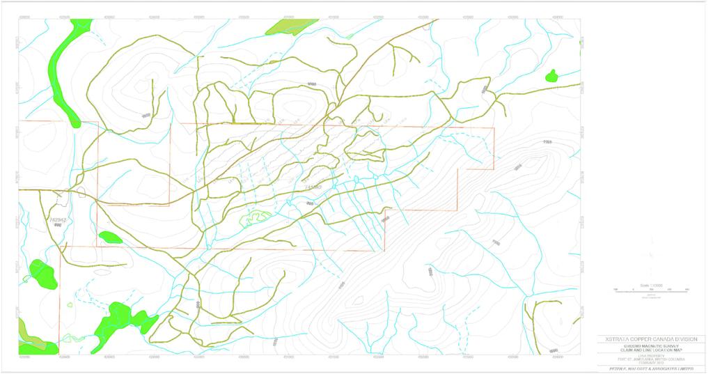
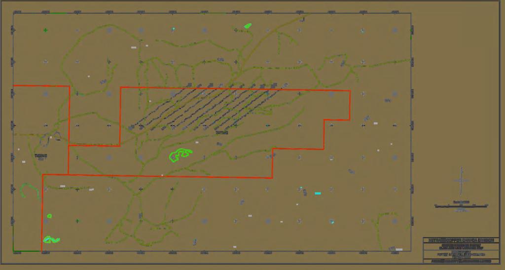
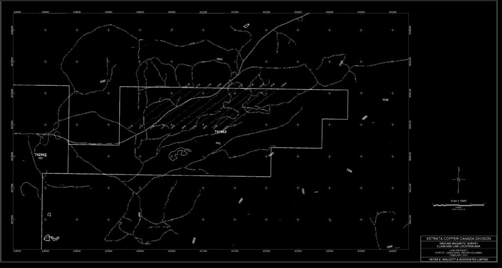
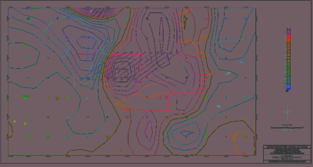
15 6 PROPERTY LOCATION AND ACCESS con t Claim and Line Location Map Peter E. Walcott & Associates Limited Geophysical Services 2013 Magnetic Surveying Lynx Property, B.C.
16 7 PURPOSE. The purpose of the survey was to fulfill assessment requirements on the property as well as to detail a small magnetic feature on the southwestern flank of a broad magnetic high, proximal to the Lynx showing. Peter E. Walcott & Associates Limited Geophysical Services 2013 Magnetic Surveying Lynx Property, B.C.
17 8 SURVEY SPECIFICATIONS. The Magnetic Survey. The magnetic survey was conducted using a GSM-19W proton precession walking magnetometer equipped with GPS manufactured by Gem Systems of Markham, Ontario, Canada. The system consisted of a rover and base magnetometers. Field Procedure A base station was established and data recorded daily at 5 second intervals, in order to monitor variations in the magnetic field over the course of the day. The lines were established using a handheld Garmin GPS, and subsequently surveyed using a GSM-19W GPS equipped magnetometer. Reading were synchronized to the onboard GPS, and obtained at 1 second intervals. Data Processing. The field data was subsequently downloaded from the respective instruments, utilizing GemLink. Rover data was then post processed using the base data in order to account for variations within the magnetic field during the course of the day. The data was subsequently loaded into to Geosoft, for additional processing and presentation. The data is presented in plan map form of Contours of Total Magnetic Intensity at a scale of 1:2,000. Peter E. Walcott & Associates Limited Geophysical Services 2013 Magnetic Surveying Lynx Property, B.C.
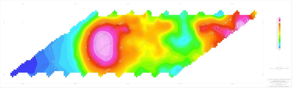
18 9 DISCUSSION OF RESULTS. The 2013 ground magnetic survey conducted over portions of Xstrata Copper s Lynx property identified a plug like magnetic anomaly some 400 meters in diameter centred at E, N. This feature has an elevated magnetic response of some 1000 nt at its centre relative the surrounding magnetic relief. Given the limited coverage of the magnetic survey meaningful interpretation of the data is severely restricted at this time.. Peter E. Walcott & Associates Limited Geophysical Services 2013 Magnetic Surveying Lynx Property, B.C.
19 10 SUMMARY, CONCLUSIONS & RECOMMENDATIONS. Between February 13 th and 16 th, 2013, Peter E. Walcott & Associates Limited conducted ground magnetic surveying on the Lynx property, located in the Ft. St. James area of British Columbia, and held by Xstrata Copper Canada. Some 12.3 kilometres of surveying was carried out over 10 northeast orientated lines. The survey identified a discrete magnetic feature some 400 metres in diameter in the western portion of the survey grid. Given the limited area covered by the magnetic survey, a detailed compilation of historic work proximal to the Lynx showing and magnetic anomaly should be undertaken in order to evaluate whether additional work should be undertaken to further examine the aforementioned feature. Respectfully submitted, PETER E. WALCOTT & ASSOCIATES LTD. Alexander Walcott Geophysicist Peter E. Walcott, P.Eng. Geophysicist Vancouver, B.C. April 2013 Peter E. Walcott & Associates Limited Geophysical Services 2013 Magnetic Surveying Lynx Property, B.C.
20 11 APPENDIX I Peter E. Walcott & Associates Limited Geophysical Services 2013 Magnetic Surveying Lynx Property, B.C.
21 12 COST OF SURVEY. Peter E. Walcott & Associates Limited undertook the survey programme on a daily basis providing two geophysicists, magnetometers, a GPS unit, and 4x4 trucks at a daily rate of $1, Accommodation and fuel costs were $1,256.71, while mobilization, split with another small project in the area, was billed at $2, Reporting costs of $ were incurred so that the total cost of services provided was $7, Peter E. Walcott & Associates Limited Geophysical Services 2013 Magnetic Surveying Lynx Property, B.C.
22 13 PERSONNEL EMPLOYED ON SURVEY. Name Occupation Address Dates Peter E. Walcott Geophysicist Fawcett Rd. April 4, 2013 Coquitlam, B.C. V3K 6V2 A. Walcott " " April 4, 2013 M. Welz " " Feb. 13th-16th, 2013 P. Young " " " Peter E. Walcott & Associates Limited Geophysical Services 2013 Magnetic Surveying Lynx Property, B.C.
23 14 CERTIFICATION. I, Peter E. Walcott, of 605 Rutland Court, Coquitlam, British Columbia, hereby certify that: 1. I am a graduate of the University of Toronto in 1962 with a B.A.Sc. in Engineering Physics, Geophysics Option. 2. I have been practicing my profession for the last fifty years. 3. I am a member of the Association of Professional Engineers of British Columbia and Ontario. 4. I hold no interest, direct or indirect, in Xstrata Copper Canada, nor do I expect to receive any. Peter E.Walcott, P.Eng. Vancouver, B.C. April 2013 Peter E. Walcott & Associates Limited Geophysical Services 2013 Magnetic Surveying Lynx Property, B.C.
24
25
26
27 Appendix B Statement of Expenditures
28 Statement of Expenditures Geophysical Survey Cost Total Peter E. Walcott and Associates $7, $7, Report Preparation Days Rate Cost Total T. Miller 1 $ $ $ Office Management Overhead Rate Cost Total Prince George Field Office & Timmins Head Office 15.00% $1, $1, Grand Total $8,690.22
PIOTR LUTYNSKI VANCOUVER, BRITISH COLUMBIA
 AN ASSESSMENT REPORT ON GROUND MAGNETIC SURVEYING CHUCHI PROPERTY FORT ST. JAMES AREA, BRITISH COLUMBIA OMINECA M.D. 55 17 N, 124 31 W NTS 93N/ 7&8 Claims Surveyed: 597976, 597878-597880 Survey Dates:
GEOPHYSICAL REPORT ON THE PRINCE GEORGE PORPHYRY PROJECT HOBBES PROPERTY
 GEOPHYSICAL REPORT ON THE PRINCE GEORGE PORPHYRY PROJECT HOBBES PROPERTY CARIBOO MINING DIVISION, British Columbia NTS: 093J/06, 093J/11 Latitude 54 30 23 N, Longitude 123 7 52 W MTO Event Numbers 4997107;
Airborne Geophysical TOTAL COST: $8, ,
 Ministry of Energy, Mines & Petroleum Resources Mining & Minerals Division BC Geological Survey Assessment Report Title Page and Summary TYPE OF REPORT [type of survey(s)]: Airborne Geophysical TOTAL COST:
ASSESSMENT REPORT ON THE PEAVINE PROJECT. DGW & Associates # Alberni Street, Vancouver, British Columbia, V6E 4V2
 ASSESSMENT REPORT ON THE PEAVINE PROJECT KAMLOOPS MINING DIVISION BRITISH COLUMBIA NTS 082M 12 Latitude 51 36' 19.0"North -- Longitude --119 47' 27.0"West UTM Zone 11, NAD 83 5720827N 306744E Prepared
, , ,
 Ministry of Energy and Mines BC Geological Survey Assessment Report Title Page and Summary TYPE OF REPORT [type of survey(s)]: Airborne Geophysic TOTAL COST: 9,4. AUTHOR(S): Walcott, A. Walcott, P SIGNATURE(S):
CAZADOR RESOURCES LTD.
 1 AN ASSESSMENT REPORT - ON INDUCED POLARIZATION SURVEYING Hit Property Aspen Grove Area, SIMILKAMEEN M.D., B.C. 49" 42" 120" 31'W 92H/lOE. For CAZADOR RESOURCES LTD. KEWWNA, BRITISH COLUMBIA \ BY PETER
, ,
 Ministry of Energy, Mines & Petroleum Resources Mining & Minerals Division BC Geological Survey Assessment Report Title Page and Summary TYPE OF REPORT [type of survey(s)]: Airborne Magnetic Survey TOTAL
LLOYD MINERALS INC. VANCOUVER, BRITISH COLUMBIA
 EVENT # 836 AN ASSESSMENT REPORT ON HELIBORNE MAGNETIC SURVEYING BIG ONION PROPERTY SMITHERS AREA, BRITISH COLUMBIA OMINECA M.D. 4 48.8 N, 6 3.76 W NTS 94L/W Claims: 374,37,376,6867,76,88893,63,64467,64468
B.C. Vancouver, Sritish Columbia. Ragas Claims, Omenica M.D., A GEOPHYSICAL REPORT. A GROUKD NAGMETIC 6: ELECTRO?.IAGr\TETIC SURVEY FOR
 A GEOPHYSICAL REPORT A GROUKD NAGMETIC 6: ELECTRO?.IAGr\TETIC SURVEY Ragas Claims, Omenica M.D., B.C. FOR CATRE - 3EK JOINT VENTURE PETER E. WALCOTT & ASSOC. LIPIITED Vancouver, Sritish Columbia OCTOEEEt
Serengeti Resources Inc GEOCHEMICAL REPORT ON THE SHADOW PROPERTY a.
 Serengeti Resources Inc. 2004 GEOCHEMICAL REPORT ON THE SHADOW PROPERTY a. Located in the Johanson Lake Area Omenica Mining Division NTS 94D/9 6 degrees and 32 minutes North Latitude 126 degrees and 2
EVENT # AN ASSESSMENT REPORT INDUCED POLARIZATION SURVEYING
 EVENT # 55345 AN ASSESSMENT REPORT ON INDUCED POLARIZATION SURVEYING Fort St. James Area, Omineca M.D., B.C. 54 56 N, 4 ' W NTS: 93N/6 Claims Surveyed: 53537, 5353, 5354, 534 Survey Dates: October st November
A REPORT. Bear Lake, British Columbia (56' 13'N, ~) N.T.S. 94 D U& Claims surveyed: BL 1, units 2
 N.T.S. 94 D U& Claims surveyed: BL 1, units 2") I PETER E. WALCOTl' Rr ASSOC. LTD. A REPORT AN INDUCED POLARIZATION SURVEY T.?. d." Bear Lake, British Columbia rnk (56' 13'N, 1270 49~) N.T.S. 94 D U& *o Claims surveyed: BL 1, units 2 *a* & 3 BL 2, units
I PETER E. WALCOTl' Rr ASSOC. LTD. A REPORT AN INDUCED POLARIZATION SURVEY T.?. d." Bear Lake, British Columbia rnk (56' 13'N, 1270 49~) N.T.S. 94 D U& *o Claims surveyed: BL 1, units 2 *a* & 3 BL 2, units
We are committed to providing accessible customer service. If you need accessible formats or communications supports, please contact us.
 We are committed to providing accessible customer service. If you need accessible formats or communications supports, please contact us. Nous tenons à améliorer l accessibilité des services à la clientèle.
--_- A GEOPHYSICAL REPORT AN INDUCED POLARIZATION-SURVEY EQUITY SILVER MINES LIMITED_. John Wesley Ma11 Daniel Morice Merkley Gloria May Merkley
 --_- PETER E. WALCOTI' & ASSOC. LTD. A GEOPHYSICAL REPORT ON AN INDUCED POLARIZATION-SURVEY Houston Area, British Columbia 54O 27'N, 126" 39'W N.T.S. 93L/7E Claims sur-ed: HD 3 & 4 Survey Dates: Sept 16th
'?a October 31, 1990 COMINCO LTD. EXPLORATION NTS: 93 G-6. Cariboo Mining Division. Latitude: 53 deg. 16' N Longitude: 123 deg.
 COMINCO LTD. EXPLORATION NTS: 93 G-6 WESTERN DISTR CT Cariboo Mining Division Latitude: 53 deg. 16' N Longitude: 123 deg. 13' W Work Dates: June 7-8, 1990 '?a October 31, 1990 D.J. Holcombe ....... A ASSESSMENT
GEOLOGICAL MAPPING REPORT ON THE ASH MINERAL CLAIM OSOYOOS MINING DIVISION ASHNOLA RIVER MAP SHEET NTS M092,H019 MCBRIDE CREEK AREA, ASHNOLA RIVER,
 GEOLOGICAL MAPPING REPORT ON THE ASH MINERAL CLAIM OSOYOOS MINING DIVISION ASHNOLA RIVER MAP SHEET NTS M092,H019 LATITUDE 49 o O6, LONGITUDE 120 o 22 MCBRIDE CREEK AREA, ASHNOLA RIVER, KEREMEOS, B.C. CANADA
UNION MINIERE EXPLORATIONS AND MINING CORPORATION LIMITED ASSESSMENT REPORT ON FITINAT MINERAL CLAIM. Alberni Mining Division Record No.
 M F )( UNION MINIERE EXPLORATIONS AND MINING CORPORATION LIMITED Suite 200, 4299 Canada Way, Burnaby, B.C. V5G 1 H4 Telephone (604) 437-9491 ASSESSMENT REPORT ON GEOCHEMICAL SOIL SURVEYS AND ROCKSAMPLING
BALFOUR MINING LTD. (N.P.L.) HAM GROUP 92-P-6, CLINTON M. D.8 B. C. Lat 51 17'N, GEOCHEMICAL REPORT. V. CUKOR, P. Eng.
 HAM GROUP 92-P-6, CLINTON M. D.8 B. C. Lat 51 17'N, GEOCHEMICAL REPORT. V. CUKOR, P. Eng.") 34q '7 BALFOUR MINING LTD. (N.P.L.) HAM GROUP 92-P-6, CLINTON M. D.8 B. C. Lat 51 17'N, Long 12lo14'W GEOCHEMICAL REPORT, V. CUKOR, P. Eng. January 31, 1972 TABLE OF CONTENTS 1. INTRODUCTION 2. PROPERTY,
34q '7 BALFOUR MINING LTD. (N.P.L.) HAM GROUP 92-P-6, CLINTON M. D.8 B. C. Lat 51 17'N, Long 12lo14'W GEOCHEMICAL REPORT, V. CUKOR, P. Eng. January 31, 1972 TABLE OF CONTENTS 1. INTRODUCTION 2. PROPERTY,
1 CLAIMS GEOPHYSICAL REPORT ON BOYAL SITUATE NORTHEAST OF TILLICUM MOUNTAIN GOLD AREA BURTON - NAKUSP SIQCAEJ MINING DIVISION
 GEOPHYSICAL REPORT ON BOYAL 1 CLAIMS SITUATE NORTHEAST OF TILLICUM MOUNTAIN GOLD AREA BURTON - NAKUSP SIQCAEJ MINING DIVISION CONSULTING GEOLOGIST AUGUST 1983 VANCOUVER B *C INDEX INTRODUCTION ooa,.eoaaa.aaaoaaooaoa~ao~o
Geology of Quesnel and Stikine terranes and associated porphyry deposits. Jim Logan Paul Schiarizza
 Geology of Quesnel and Stikine terranes and associated porphyry deposits Jim Logan Paul Schiarizza Quesnel and Stikine terranes Major cordilleran terranes characterized by similar Late Triassic Early Jurassic
Report of Gridding and Magnetic Surveys. On the. Munro Property. Munro and Beatty Townships, Ontario. Larder Lake Mining Division
 Report of Gridding and Magnetic Surveys On the Munro Property Munro and Beatty Townships, Ontario Larder Lake Mining Division Claims: 39 4244 For Big Red Diamond Corporation October 3, 2 Timmins, Ontario
QUALITATIVE INTERPRETATION OF POTENTIAL FIELD PROFILES: SOUTHERN NECHAKO BASIN
 QUALITATIVE INTERPRETATION OF POTENTIAL FIELD PROFILES: SOUTHERN NECHAKO BASIN By Melvyn E. Best Bemex Consulting International 5288 Cordova Bay Road Victoria, B.C. V8Y 2L4 KEYWORDS: potential fields,
PHYSICAL WORK REPORT. the BAY CLAIMS. Omineca Mining Division Smithers, British Columbia N.T.S. 93E 13E/W
 PHYSICAL WORK REPORT the BAY CLAIMS Omineca Mining Division Smithers, British Columbia a N.T.S. 93E 13E/W LATITUDE: 53 57 00 N I LONGITUDE: 127 45 OO W for Home Ventures Ltd. 1201-675 West Hastings Street
for the Greenwood Mining Division, B.C. NTS 82E/7W 29' W, Longitude 118' 53' N Prepared by D. Dylan Watt, B.Sc.
 for the FltE NO: u VOLT 1, VOLT 2, VOLT 3, & VOLT 4 CLAIMS Greenwood Mining Division, B.C. NTS 82E/7W Latitude 49' 29' W, Longitude 118' 53' N Prepared by D. Dylan Watt, B.Sc. #309-1996 Trutch Street Vancouver,
The survey covered claims, in part or in full, DUCKLING 3, 4, 5, 4 fraction, and 5 fraction.
 514 687-6671 XXX- 602 West Hastin~a StroeP, Vata;sn@ouver, BritlsA fhlum~b~a, Garaadsa B81apphgtaa DISCUSS ION OF MAGNETOMETER SURVEY ON DUCKLING CLAIMS FOR DONNA MINES LTD. (N0P.L.) Submitted to: DONNA
for the Greenwood Mining Division, B.C. NTS 82E/7W Latitude 49' 27' W, Longitude 118' 5 Prepared by a= D. Dylan Watt, B.Sc.
 t. b LOGnO: 37~ -08 m. ACTIO#: for the AMP AMP 2 AMP 3 t AMP 4 CLAIMS Greenwood Mining Division, B.C. NTS 82E/7W Latitude 49' 27' W, Longitude 8' 5 %E c,w zc *& a w Prepared by a= -4c. D. Dylan Watt, B.Sc.
Fox 2-Record No. 2524
 F HELICOPTER E.M. AND MAGNETOMETER SURVEY OVER THE FOX CLAIMS, OMINECA MINING DISTRICT BRITISH COLUMBIA ON BEHALF OF OWNER MR. MIKE BOYLE Claims: Fox l-record No. 2523 Fox 2-Record No. 2524 Location 126'
We are committed to providing accessible customer service. If you need accessible formats or communications supports, please contact us.
 We are committed to providing accessible customer service. If you need accessible formats or communications supports, please contact us. Nous tenons à améliorer l accessibilité des services à la clientèle.
Geological & Geophysical Interpretation of ZTEM EM and Magnetic Survey. Kemess Project, BC. for AuRico Metals Inc. September, 2016 Nicole Pendrigh
 Geological & Geophysical Interpretation of ZTEM EM and Magnetic Survey Kemess Project, BC for AuRico Metals Inc. September, 2016 Nicole Pendrigh SUMMARY REPORT Regional setting Located in North central
7 MILES WEST OF PORT HARDY, B.C.
 GEOPHYSICAL REPORT VERTICAL INTENSITY MAGNETOMEER SURVEY ON LUK CLAIMS, 7 MILES WEST OF PORT HARDY, B.C. 50' 127O SE BY R. E. SHIELDS UNDER SUPERVISION OF J. R. BILLINGSLEY FOR SECOND0 MINING LTD. (N.
GEOPHYSICAL ASSESSMENT REPORT ON THE CATALAN COPPER PROPERTY
 GEOPHYSICAL ASSESSMENT REPORT ON THE CATALAN COPPER PROPERTY McLeese Lake Area, B.C. NTS Map No. 93B/09 52"30'N Latitude 122"lO'W Longitude For: Operator, Stikine Gold Corporation 490-1 122 Mainland St.
A GEOPHYSICAL REPORT INDUCED POLARIZATION & MAGNETIC SURVEYING
 I A GEOPHYSICAL REPORT INDUCED POLARIZATION & MAGNETIC SURVEYING Bluff Property,,- Cariboo Mining District, B.G4 52"Ol'N, 121" 187W%\% 1,-. N.T.S. 93A004(\? c, ',
GOLDCLIFF TULAMEEN PORPHYRY COPPER PROJECT COPPER MOUNTAIN CAMP, BRITISH COLUMBIA THE TROJAN-CONDOR COPPER TARGET HIGHLIGHTS
 Suite 350-885 Dunsmuir Street PF 250 764 8879 TF 866 769 4802 Vancouver, BC, Canada FX604 261 8994 info@goldcliff.com V6C 1N5 GCN.TSXV www.goldcliff.com GOLDCLIFF TULAMEEN PORPHYRY COPPER PROJECT COPPER
490 20' 30" North Latitude ' 30" West Longitude
 _._.. I CONSULTING GEOLOGISTS 605-602 WEST HASTINGS STREET, VANCOUVER, B.C. V6B 1P2 TELEPHONE: (604) 689-5533 6 I F: ASSESSMENT REPORT ON THE PATSY 1 MINERAL CLAIM ' '?%2% I WHISTLE CREEK, HEDLEY ARE L-l-
PRECIOUS METALS. owner. JMT Services Corp. GEOCHPlICAL SAMPLING CHELASLIE WCE, NORTH CENTRAL, B.C. OMINECA MINING DIVISION NTS 93F/5E & 6W
 PRECIOUS METALS REPORT ON 1980 RECONNAISSANCE GEOCHPlICAL SAMPLING CHELASLIE WCE, NORTH CENTRAL, B.C. OMINECA MINING DIVISION NTS 93F/5E & 6W LATITUDE 53O28 N LONGITUDE 125O31 W DATES Qp WORK: JULY 10
NOTICE OF WORK PERMIT NUMBER(S)/DATE(S):
/DATE(S):") Ministry of Energy, Mines & Petroleum Resources Mining & Minerals Division BC Geological Survey Assessment Report Title Page and Summary TYPE OF REPORT [type of survey(s)]: Airborne Magnetic Survey TOTAL
Ministry of Energy, Mines & Petroleum Resources Mining & Minerals Division BC Geological Survey Assessment Report Title Page and Summary TYPE OF REPORT [type of survey(s)]: Airborne Magnetic Survey TOTAL
COMINCO LTD. HORIZONTAL LOOP EM AND MAGNETIC SURVEYS ON SHA. CLAIMS 1, 2, 7 and 8 NELSON AND FORT STEELE MINING DIVISIONS, B.C.
 COMINCO LTD. EXPLORATION WESTERN DISTRICT NTS: 82-F/1 HORIZONTAL LOOP EM AND MAGNETIC SURVEYS ON SHA CLAIMS 1, 2, 7 and 8 - ASSESSMENT REPORT - NELSON AND FORT STEELE MINING DIVISIONS, B.C. Latitude Longitude
ASSESSMENT' REPORT GEOPHYSICAL REPORT ON THE ATTORNEY 2 CLAIM (4 UNITS) OMINECA MINING DIVISION SHEILA A. CRAWFORD.
 OMINECA MINING DIVISION SHEILA A. CRAWFORD.") ASSESSMENT' REPORT GEOPHYSICAL REPORT ON THE ATTORNEY 2 CLAIM (4 UNITS) OMINECA MINING DIVISION by SHEILA A. CRAWFORD LOCATION: 57z17' N Latitude 127 11' W Longitude N.T.S. 94E/6E OWNER/OPERATOR: SEREM
ASSESSMENT' REPORT GEOPHYSICAL REPORT ON THE ATTORNEY 2 CLAIM (4 UNITS) OMINECA MINING DIVISION by SHEILA A. CRAWFORD LOCATION: 57z17' N Latitude 127 11' W Longitude N.T.S. 94E/6E OWNER/OPERATOR: SEREM
Trout Lake Area, British Columbia (500, 50' N., 117O 40' t?) Claims surveyed: WE, VIK. Survey Dates: June 6th - " 12th, 84 FOR
 Claims surveyed: WE, VIK. Survey Dates: June 6th - 12th, 84 FOR") PETER E. WALCOTT Rr ASSOC. LTD. P ~ L C ~ \%%95 GEOLOGICAL BRANCH ASSb:fiSMENT REPOPT A GEOPlIYSICAL REPORT Trout Lake Area, British Columbia (500, 50' N., 117O 40' t?) Claims surveyed: WE, VIK Survey
PETER E. WALCOTT Rr ASSOC. LTD. P ~ L C ~ \%%95 GEOLOGICAL BRANCH ASSb:fiSMENT REPOPT A GEOPlIYSICAL REPORT Trout Lake Area, British Columbia (500, 50' N., 117O 40' t?) Claims surveyed: WE, VIK Survey
REPORT. on the. Omineca Mining Division, British Columbia. Latitude N., Longitude W. NTS map sheet 93F/7E. James W. McLeod, P.Geo.
 REPORT on the CHU MOLYBDENUM PROPERTY Omineca Mining Division, British Columbia Latitude 53 21 N., Longitude 124 37 W. NTS map sheet 93F/7E James W. McLeod, P.Geo. on behalf of Mr. Chris Delorme TABLE
PHOENIX GEOPHYSICS LIMITED REPORT ON THE VLF-EM AND TOTAL FIELD MAGNETOMETER SURVEYS ON THE
 PHOENIX GEOPHYSICS LIMITED REPORT ON THE VLF-EM AND TOTAL FIELD MAGNETOMETER SURVEYS ON THE TAN CLAIMS, CHILLIWACK AREA NEW WESTMINSTER MINING DIVISION, BRITISH COLUMBIA FOR LORNEX MINING CORPORATION LIMITED
2013 GEOLOGICAL ASSESSMENT REPORT SHERIDAN HILL PROPERTY
 2013 GEOLOGICAL ASSESSMENT REPORT ON THE SHERIDAN HILL PROPERTY NEW WESTMINSTER MINING DIVISION BRITISH COLUMBIA NTS 092G07 49 16 31 NORTH LATITUDE, 122 39 48 WEST LONGITUDE PREPARED FOR Sheridan Hill
GEOPHYSICAL REPORT THE CAVZ CLAIMS
 GEOPHYSICAL REPORT Magnetometer Survey on THE CAVZ CLAIMS CAVZ M.C.'s 1 to 12, 15 to 26, 29 to 40, 45 to 54 Trail Peak, Omineca M.D. 13 miles northeast of Fort Babine 550 ) 126 S.E. by G.Podolsky J.Russell
r Department of Mines and P,1Pr2!sum Resources I ... ' AS f 5 5 E t.! T R E p (J RT Mt, Sicker, Duncan Area, Vancouver Island, B.C.
 45- I A REPORT - ON AN ELECTROMAGNETIC SURVEY Mt, Sicker, Duncan Area, Vancouver Island, B.C. DUCANEX RESOURCES LIMITED Vancouver, British Columbia r Department of Mines and P,1Pr2!sum Resources I AS f
PROSPECTING REPORT THE WALLACE CLAIM OMENICA MINING DIVISION. 54" x6" 3.d d. for. Reako Exlorat ions Ltd. Wallace Rev. C.G.
 PROSPECTING REPORT ON THE WALLACE CLAIM OMENICA MINING DIVISION 54"44 14 1x6" 3.d d by David A. Howard P.Eng. for Reako Exlorat ions Ltd. Claim Locat ion Wallace Rev. C.G. #1560 Dome Mountain Area 9 3
Gold Mountain Group Gold Mtn. A, B, C & D Mineral Claims Record Nos. 697, 698, 699 & 700. Island Mountain Cariboo Mining Division British Columbia
 GOLD POINT RESOURCES LTD. Geophysical Survey Gold Mountain Group Gold Mtn. A, B, C & D Mineral Claims Record Nos. 697, 698, 699 & 700 Island Mountain Cariboo Mining Division British Columbia Vancouver,
Serengeti Resources Inc GEOCHEMICAL REPORT ON THE DARBY PROPERTY
 Serengeti Resources Inc. 2005 GEOCHEMICAL REPORT ON THE DARBY PROPERTY Located in the Johanson Lake Area Omenica Mining Division NTS 94D/9 56 degrees and 34 minutes North Latitude 126 degrees and 9 minutes
HELICOPTER MAGNETIC SURVEY MISINCHINKA RANGE AREA, B.C. ONINECA MINING DIVISION. on behalf of STOKES EXPLORATION MANAGEMENT LTD.
 HELICOPTER MAGNETIC SURVEY MISINCHINKA RANGE AREA, B.C. ONINECA MINING DIVISION on behalf of STOKES EXPLORATION MANAGEMENT LTD. Claims : FALCON $1, FALCON #2 Location: Dated: About 7% kilometers N.E. of
Introducti on. Land Survey. Geomagnetic Survey. Geomagnetic Results and Interpretati ons - Conclusions and Recommendations C
 m M 42A86SW8281 63.42 PRICE 010 C O H T E H l 42A86SW828I 63.42 PRICE 010C Introducti on Land Survey Geomagnetic Survey Geomagnetic Results and Interpretati ons - Conclusions and Recommendations - - -
GEOPHYSICAL REPORT INDUCED POLARIZATION/RESISTMTY SURVEYS. on behalf of TEESHIN REOURCES LTD Argus Road. Oakville, Ontario L6J 354
 GEOPHYSICAL REPORT INDUCED POLARIZATION/RESISTMTY SURVEYS DOME MOUNTAIN PROPERTY, SMITHERS AREA CHRIS, APRIL 1, APRIL 2, APRIL 3, AND MAG 1 CLAIMS CMINECA MINING DMSION, BRITISH COLUMBIA Latitude: 546
Beekeeper Property The Geology South of Mint Lake. Cariboo Mining Division
 Beekeeper Property The Geology South of Mint Lake NTS: 93A/6 Cariboo Mining Division Claims: Beekeeper 1 #I2055 Beekeeper 2 #3892 Beekeeper 3 #7895 Beekeeper 4 #8503 Latitude: Longitude: 52 degrees 24
GRAVITY AND MAGNETIC SURVEY NECHAKO BASIN STUDY ACQUISITION AND PROCESSING PHASE
 GRAVITY AND MAGNETIC SURVEY NECHAKO BASIN STUDY ACQUISITION AND PROCESSING PHASE Report prepared for the B.C. Ministry of Energy and Mines Resource Development Division New Ventures Branch by Bemex Consulting
PROSPECTORS ASSISTANCE PROGRAM MINISTRY OF ENERGY AND MINES
 BRITISH COLUMBIA PROSPECTORS ASSISTANCE PROGRAM MINISTRY OF ENERGY AND MINES GEOLOGICAL SURVEY BRANCH PROGRAM YEAR: 1999/2000 REPORT #: PAP 99-l 6 NAME: KIM ANSCHETZ PROSPECTORS TlEPORT on the 99 LOUIS
SUMMARY REPORT. RE-ESTABLISH CLAIM BOUNDARY (Claim ) CARR TOWNSHIP (Larder Lake Mining Division) NTS (42 Al09) FOR
 CARR TOWNSHIP (Larder Lake Mining Division) NTS (42 Al09) FOR") 2.44330 " SUMMARY REPORT RE-ESTABLISH CLAIM BOUNDARY (Claim 3002288) CARR TOWNSHIP (Larder Lake Mining Division) NTS (42 Al09) FOR ST ANDREW GOLDFIELDS LTD. ""'1,.I Les 1. Kovacs, P. Geo For: St Andrew
2.44330 " SUMMARY REPORT RE-ESTABLISH CLAIM BOUNDARY (Claim 3002288) CARR TOWNSHIP (Larder Lake Mining Division) NTS (42 Al09) FOR ST ANDREW GOLDFIELDS LTD. ""'1,.I Les 1. Kovacs, P. Geo For: St Andrew
A New Direction. Copper-Gold Deposit at Thor TSX.V:COL. August 11, May 2013
 A New Direction Copper-Gold Deposit at Thor August 11, 2016 May 2013 TSX.V:COL FORWARD LOOKING STATEMENTS This presentation includes certain forward-looking information or forward-looking statements for
We are committed to providing accessible customer service. If you need accessible formats or communications supports, please contact us.
 We are committed to providing accessible customer service. If you need accessible formats or communications supports, please contact us. Nous tenons à améliorer l accessibilité des services à la clientèle.
ON THE LOST GOLD PROPERTY
 ON THE LOST GOLD PROPERTY NELSON MINING DIVISION BRITISH COLUMBIA Latitude: 49 18 North Longitude: 117 29.West TRIM MAPS: 82F1023,033 NTS: 8tF/5,6 By: Fred Critchlow . TABLE OF CONTENTS r PAGE lutroduction
Mineral Claims. Aspen Grove Area Nicola Mining Division, British Columbia. Latitude N., Longitude W. NTS Map Sheet 92H/lSE
 Mineral Claims Aspen Grove Area Nicola Mining Division, British Columbia Latitude 49 51 N., Longitude 120 35 W. NTS Map Sheet 92H/lSE James P. Balmer, B.SC., P.Geo. on behalf of Gary Brown November 26,2003
Total Magnetic Field and VLF Surveys on the Swayze Property. Claim Swayze Township. Porcupine Mining Division
 1 January, 016 NTS: 041 O 15 Total Magnetic Field and VLF Surveys on the Swayze Property Claim 475471 Swayze Township Porcupine Mining Division 380850E, 599450N UTM Z17N NAD83 Report Prepared for: 540
CONTENTS. Location, Access and History...6. Tenure Status and Geology Regional Andy Property Geology Map...9
 TYPE OFWORK IN THIS REPORT EXTENT OF WORK (rn METRTC UNITS) ON WHICH CLAIMS PROJECT COSTS APPORTIONED (incl. support) GEOLOGICAL (scale, area) Ground, mapping Photo interpretation GEOPHYSICAL (line-kilometres)
TIGER GOLD EXPLORATION CORPORATION. Prospecting Over the HARKER HERITAGE PROPERTY AREA 10. Harker Township, Ontario
 PO Box 219, 14579 Government Road, Larder Lake, Ontario, P0K 1L0, Canada Phone (705) 643-2345 Fax (705) 643-2191 www.cxsltd.com TIGER GOLD EXPLORATION CORPORATION Prospecting Over the HARKER HERITAGE PROPERTY
NTS 93L/9W GEOCHEMICAL AND GEOPHYSICAL REPORT MONA CLAIM OMINICA MINING DIVISION. Lati tude 54036'N; Longitude 'W
 GEOCHEMICAL AND GEOPHYSICAL REPORT ON MONA CLAIM OMINICA MINING DIVISION Lati tude 54036'N; Longitude 126018'W NTS 93L/9W April 1981 Paul Plicka Consulting Geologist LOCATION MAP INTRODUCTION TABLE OF
BRY PLACER GROUP. Assessment Report Gravel,silt sampling and panning on. Claims: , , Located on map sheet 093A 062
 BRY PLACER GROUP Assessment Report 2012 Gravel,silt sampling and panning on Claims: 523068, 522278, 589718 Located on map sheet 093A 062 5~2 57'3/A/ / 31 Hi' 9 " )Aj Cariboo D/viS''on Owner-operator Egil
REPORT ON MAGNETOMETER SURVEY TIK-1 CLAIM e&f KAMLOOPS MINING DTVISION. by D. Hendry D. C. MILLER. February 3, for
 REPORT ON MAGNETOMETER SURVEY TIK-1 CLAIM 92-1-14 e&f KAMLOOPS MINING DTVISION lat. 50 57 ' 12" long. 121O23 ' 37" OWNER: ST. JOSEPH EXPLORATIONS LIMITED OPERATIOR: ST. JOSEPH EXPLORATIONS LIMITED by D.
A Report on a Magnetometer Survey. Division, British Columbia. Gypsy 1-32 and Gypsy 1 Fr-9 Fr. 27 miles north of Smithers
 - A Report on a Magnetometer Survey on the Gypsy Claims, Omineca Mining Division, British Columbia Covering: Gypsy 1-32 and Gypsy 1 Fr-9 Fr Located: 27 miles north of Smithers Latitude 55O11' N Longitude
1 i I.; :<7 6EOLOGICAL BRANCH ASSESSMENT REPORT HLEM, VLF-EM AND MAGNETOMETER TEST SURVEY ON THE ARC PROPERTY FOR SURVEY BY SJ GEOPHYSICS LTD.
 f - ~ --- j LOG NO: MAR 2 a 1992,,, -- - - - -- L$TiC'P;: I.; 1 i HLEM, VLF-EM AND MAGNETOMETER TEST SURVEY ON THE ARC PROPERTY FOR SURVEY BY SJ GEOPHYSICS LTD. SLOCAN M.D., B.C. N.T.S. 88 F/10 d 2- :
September 23rd-26th, 2016,May 18th, 2017 YEAR OF WORK: 16/ , , ,
 Ministry of Energy and Mines BC Geological Survey Assessment Report Title Page and Summary TYPE OF REPORT [type of survey(s)]: induced polarization/airborne magnetic TOTAL COST: 23,4 AUTHOR(S): Walcott,
SUPPLEMENT TO MAGNETOMETER 6 ELECTROMAGNETIC SURVEY REPORT. DATED NOVEMBER l, 1973 CIGLEN INVESTMENTS LIMITED CLAIMS GROUP BAD VERMILLION LAKE AREA
 ^ A R l ^ 1974 010 PROJECTS UNIT SUPPLEMENT TO MAGNETOMETER 6 ELECTROMAGNETIC SURVEY REPORT DATED NOVEMBER l, 1973 CIGLEN INVESTMENTS LIMITED CLAIMS GROUP BAD VERMILLION LAKE AREA DISTRICT OF RAINY RIVER
Lat. 52' 43' N Long ' W
 &A exploration ltd MINING ENGINEERING GEOLOGY- GEOPHYSICS 4570 HOSKINS ROAD, NORTH VANCOUVER, 6. C. TELEPHONE (804) 985,7921 V7K 2R1 GEOLOGICAL AND GEOCHEMICAL REPORT on the BLUE CLAIMS Cariboo Mining
ASSESSMENT REPORT TITLE PAGE AND SUMMARY
 ASSESSMENT REPORT TITLE PAGE AND SUMMARY TITLE OF REPORT: Assessment Report on Andys Bridge Mineral Claim, Turnagain River Area TOTAL COST: $2,100 AUTHOR(S): Bruce w Downing SIGNATURE(S): Bruce W Downing
SUMMl'l WlLS LIU. GEOPHYSICAL REPORT. W. CT. a~evenson Y I
 SUMMl'l WlLS LIU. GEOPHYSICAL REPORT W. CT. a~evenson Y3 qi@, 1970. I 2-90 9 CONTENTS - PAGE Introduction... 1 Property... 1 Location and Access... 1 Survey Specifications Survey Grid... 1 Induced Polarization
J.D. Mason, Prof. Engineer. Report on the Reconnaissance Magnetometer Survey. Completed for. North American Platinum Corporation Ltd.
 Report on the Reconnaissance Magnetometer Survey Completed for North American Platinum Corporation Ltd. Olivine Mountain Property, Tulameen, B.C. J.D. Mason, Prof. Engineer. November 28, 1967. Certificate
TOPOGRAPHICAL SURVEY REPORT ON THE GREENDROP PROPERTY NEAR CHILLIWACK, B.C. 92-H-3/W
 TOPOGRAPHICAL SURVEY REPORT ON THE GREENDROP PROPERTY NEW WESTMINSTER M.D. NEAR CHILLIWACK, B.C. 92-H-3/W Location: The central pap of the claims is located at coordinates 49 08'N, latitude by 121 26'W,
BALTO RESOURCES LTD. (Owner & Operator) GEOPHYSICAL ASSESSMENT REPORT. (Event Number ) on the SED MINERAL CLAIM.
 GEOPHYSICAL ASSESSMENT REPORT. (Event Number ) on the SED MINERAL CLAIM.") BALTO RESOURCES LTD. (Owner & Operator) GEOPHYSICAL ASSESSMENT REPORT (Event Number 5173274) on the SED MINERAL CLAIM (Tenure 392163) Kamloops Mining Division NTS 092I.047 Centre of Work 5589550N, 667600E
BALTO RESOURCES LTD. (Owner & Operator) GEOPHYSICAL ASSESSMENT REPORT (Event Number 5173274) on the SED MINERAL CLAIM (Tenure 392163) Kamloops Mining Division NTS 092I.047 Centre of Work 5589550N, 667600E
GEOPHYSICAL REPORT. Airborne Magnetometer Survey. of the SHEEP-GOAT GROUP OF MINERAL CLAIMS. near Li l looet, B.C.
 GEOPHYSICAL REPORT 977 Airborne Magnetometer Survey of the SHEEP-GOAT GROUP OF MINERAL CLAIMS near Li l looet, B.C. Lillooet Mining Division (Lat.51 'lot Long. 122 40' 7 5t0[2L05E. for DUFFEY LAKES MINES
For personal use only
 VICTORIAN PORPHYRY COPPER GOLD TENEMENTS GRANTED ASX ANNOUNCEMENT 13 AUGUST 2013 Mantle Mining Corporation Limited (ASX: MNM) is pleased to report that three exploration licences highly prospective for
GEOLOGICAL BRANCH ASSESSMENT REPORT
 GEOLOGICAL BRANCH ASSESSMENT REPORT REPORT ON GEOPHYSICAL GROUND SURVEYS ON THE CHILI CLAIM MAGNETIC, VLF DIP ANGLE ELECTROMAGNETIC, AND VLF RESISTIVITY SURVEYS BY HI LIMION SEPTEMBER 12, 1986 &! FILMED
SELF POTENTIAL SURVEY OVER THE JAY GROUP, INVERMERE AREA GOLDEN MINING DIVISION, BFUTISH COLUMBIA NTS 82W8W7 82W9W LATLONG 50 30' ' FOR
 - GEOLOGICAL SURVEY BRANCH ASSESSMENT REPORTS -- -- DATE RECEI?/::D 06T 10 1996 - SELF POTENTIAL SURVEY OVER THE JAY GROUP, INVERMERE AREA GOLDEN MINING DIVISION, BFUTISH COLUMBIA NTS 82W8W7 82W9W LATLONG
a 93 J GEOLOGICAL BRANCH ON THE COMINCO LTD. EXPLORATION WESTERN DISTRICT ASSESSMENT REPORT GEOPHYSICAL SURVEYS WEE 4,5,8,12 MINERAL CLAIMS
 COMNCO LTD. EXPLORATON a 93 J 10111 WESTERN DSTRCT ASSESSMENT REPORT ON GEOPHYSCAL SURVEYS ON THE WEE 4,5,8,12 MNERAL CLAMS Record No's 9568, 9569, 10219, 10512 Cariboo Mining Division Latitude: 54 den.
Verification Rock Geochemical Survey on the Casino Property
 Verification Rock Geochemical Survey on the Casino Property Trail Creek Mining Division British Columbia NTS 082F04 Latitude 49 04 40.3 North Longitude 117 39 1.4 West UTM Zone 11, NAD 83 5436320N 452500E
CONSULTING GEOLOGICAL 8: MINING ENGINEERS STINGS STREET DA V6E 2E9 GEOPHYSICAL SURVEY SILVER QUEEN 2 ZEBALLOS AREA. B.C.
 DOLMAGE CAMPBELL & ASSOCIATES (1 975) LTD. CONSULTING GEOLOGICAL 8: MINING ENGINEERS STINGS STREET DA V6E 2E9 '' 1E O L 0 G I C A.L B'x;&a:f2:#& 'SESSMENT REPObT 12, Assessment RESOURCES LTD. 111 ReDort
News Release No GOLD AND COPPER MINERALIZATION DISCOVERED DURING PHASE 2 EXPLORATION AT THE MCBRIDE PROPERTY
 November 19, 2018 TSX Venture Exchange Listed Frankfurt Exchange Listed News Release No. 303-2018 GOLD AND COPPER MINERALIZATION DISCOVERED DURING PHASE 2 EXPLORATION AT THE MCBRIDE PROPERTY Vancouver,
Structural Analysis Using Hillshade Imagery. on the. LLC Property
 Structural Analysis Using Hillshade Imagery on the LLC Property Liard Mining Division NTS 104F/16W Latitude: 57 53' 47'' N Longitude: 132 03' 06'' W Owner Garry John Payie 3714 Raymond Street South, Victoria,
ASSESSMENT REPORT TITLE PAGE AND SUMMARY
 ASSESSMENT REPORT TITLE PAGE AND SUMMARY TITLE OF REPORT: Assessment Report on An Induced Polarization, Lac La Hache, in the Lac La Hache area, westcentral British Columbia Clinton Mining Division TOTAL
ASSESSMENT REPORT. including. IP and MMI Sampling. on the MP PROPERTY
 ASSESSMENT REPORT including IP and MMI Sampling on the MP PROPERTY CARIBOO MINING DIVISION, British Columbia NTS: 93G/09 Latitude 53 41' N, Longitude 122 24' W Prepared for Operators: FJORDLAND EXPLORATION
GEOPHYSICAL REPORT ON AN INDUCED POLAR.IZATION SURVEY
 GEOPHYSICAL REPORT ON AN INDUCED POLAR.IZATION SURVEY T & V Claim Groups some 12 miles Northwest of Babine Lake, B.C. Latitude 55' 26'N Longitude 126' 35'W AUTHOR: Glen E. White, Chief Geophysicist,a,
WORK REPORT. on the ALEXO PROPERTY DUNDONALD TOWNSHIP PORCUPINE MINING DIVISION. for LIBERTY MINES INC.
 GEOSCIE CE AS r::;ss lent OFFICE WORK REPORT on the ALEXO PROPERTY DUNDONALD TOWNSHIP PORCUPINE MINING DIVISION for LIBERTY MINES INC. 2. 340 51 Submitted by: Steve Anderson VISION EXPLORATION 2041663
BALTO RESOURCES LTD. (Owner & Operator) GEOPHYSICAL ASSESSMENT REPORT. (Event Number ) on the SED MINERAL CLAIM.
 GEOPHYSICAL ASSESSMENT REPORT. (Event Number ) on the SED MINERAL CLAIM.") BALTO RESOURCES LTD. (Owner & Operator) GEOPHYSICAL ASSESSMENT REPORT (Event Number 4829051) on the SED MINERAL CLAIM (Tenure 392163) Kamloops Mining Division NTS 092I.047 Centre of Work 5590150N, 678800E
BALTO RESOURCES LTD. (Owner & Operator) GEOPHYSICAL ASSESSMENT REPORT (Event Number 4829051) on the SED MINERAL CLAIM (Tenure 392163) Kamloops Mining Division NTS 092I.047 Centre of Work 5590150N, 678800E
R.A. COMINCO LTD. EXPLORATION NTS: 92H/16. WESTERN DISTRICT January 6, 1982 ASSESSMENT REPORT 1981 SOIL GEOCHEMISTRY ON THE TROUT PROPERTY
 COMINCO LTD. EXPLORATION NTS: 92H/16 WESTERN DISTRICT January 6, 1982 ASSESSMENT REPORT 1981 SOIL GEOCHEMISTRY ON THE TROUT PROPERTY (Trout 1 and 6 Claims) SIWASH LAKE AREA, SIMILKAMEEN M.D., B.C. (Work
Mines Act Permit MX km East of Dease Lake, B.C. in the Skeena Mining Division. NTS Location at 1:50,000 Scale NAD 27 Base Map 104I 7
 TECHNICAL ASSESSMENT REPORT on the JEDWAY PROPERTY Mines Act Permit MX-1-904 62 km East of Dease Lake, B.C. in the Skeena Mining Division NTS Location at 1:50,000 Scale NAD 27 Base Map 104I 7 Centered
MtNERAL EXPLORATION CONSULTANTS ASSESSMENT REPORT MT. MILLIGAN AREA OMINECA M.D. Latitude: 55' 07' N Longitude: 123" 56' W NTS : 93 0/4 W.
 D. L. COOKE AND ASSOCIATES LTD. MtNERAL EXPLORATION CONSULTANTS ASSESSMENT REPORT 1989 PRELIMINARY GEOCHEMICAL SURVEY KC MINERAL CLAIMS MT. MILLIGAN AREA OMINECA M.D. Latitude: 55' 07' N Longitude: 123"
NTS 082F03SW N W U E N
 Prospecting Report JOCELYN CLAIM NTS 082F03SW N49 09 51 W 117 14 04 11U 482906E 5445737N NELSON MINING DIVISION Martin Ross PO Box 323 Salmo BC V0G 1Z0 Jan 31, 2012 PROSPECTING REPORT JOCELYN MINERAL CLAIM
PROSPECTING Survey Over the AULD PROPERTY Auld Township, Ontario
 PO Box 219, 14579 Government Road, Larder Lake, Ontario, P0K 1L0, Canada Phone (705) 643-2345 Fax (705) 643-2191 www.cxsltd.com PROSPECTING Survey Over the AULD PROPERTY C Jason Ploeger, B.Sc, P.Geo August
ASSESSMENT REPORT MAGNETOMETER SURVEY GOLDEN ROD, GOLDEN ROD #2. Long.: General Delivery, Vananda, B. C.
 ASSESSMENT REPORT MAGNETOMETER SURVEY GOLDEN ROD, GOLDEN ROD #2 t=/ NTS 92~110w Lat.: Long.: 49O 44' N 124O 34' W Owner: E. Johanson General Delivery, Vananda, B. C. Operator: Rhyolite Resources I nc.
REPORT ON DIAMOND DRILLING SUBSTITUTION EAST PROPERTY CLAIMS AND HEBERT TOWNSHIP ONTARIO, CANADA
 REPORT ON DIAMOND DRILLING SUBSTITUTION EAST PROPERTY CLAIMS 1248920 AND 1248921 HEBERT TOWNSHIP ONTARIO, CANADA Adroit Resources Inc. Suite #610-1111 Melville Street Vancouver, British Columbia, Canada
GEOCSZNICAL - SURVEY. ICAMLOOPS Kl.D. 2'' 6;kr. HY "'f. Alfred R. Allen,P.Eng. 1 NO.%=...,... 6"- 'I.
 t i.i GEOCSZNICAL - SURVEY i p' ICAMLOOPS Kl.D. 2'' 6;kr HY 50-64 +."'f 121-51 NE 5-10-70 : 19-10-70 Alfred R. Allen,P.Eng. I) ' 1 6"- 'I. 1 NO.%=...,..... Q.C. EXPLORATIONS LTD. 2Cl- 535 Kowe Street Vancouver
 Assessment Report Geophysical Technical Report on Placer Claim: 897 BC Geological Survey Assessment Report 68 Cariboo Mining Division British Columbia Latitude 8 N. Longitude W NTS map sheet, 09A/E Owner:
ASSESSMENT REPORT I.P./RESISTIVITY AND MAGNETICS SURVEY ON THE HAUTETE PROPERTY LATITUDE: 55O 12' N LONGITUDE: 126O 07' W
 NTS: 93W1 ASSESSMENT REPORT I.P./RESISTIVITY AND MAGNETICS SURVEY ON THE HAUTETE PROPERTY LATITUDE: 55O 12' N LONGITUDE: 126O 07' W OMINECA MINING DISTRICI'. B.C. CLAIMS COVERED : TET 1-8 TIME PERIOD:
Prospecting Report Grandpa Claim Group
 2010 2011 Prospecting Report Grandpa Claim Group TENURE NUMBER: 705523 EVENT NUMBER: 4825383 TENURE NAME: GRANDPA Lillooet Mining Division Map 092I Central Coordinate Reference 50 57 30 N Latitude 121
'-7' REPORT ON A MAGNETOMETER SURVEY OVER PART OF THE MAX CLAIM GROUP 1-20 LAC LE JEUNE AREA KAMLOOPS MINING DIVISION KAMLOOPS, BRITISH COLUMBIA
 I,., - SUITE 102. 222 BELLEVUE WES t ANCOUVER, B. '-7' REPORT ON A I MAGNETOMETER SURVEY OVER PART OF THE MAX CLAIM GROUP 1-20 LAC LE JEUNE AREA KAMLOOPS MINING DIVISION KAMLOOPS, BRITISH COLUMBIA 50-30