Serengeti Resources Inc GEOCHEMICAL REPORT ON THE SHADOW PROPERTY a.
|
|
|
- Denis Norton
- 5 years ago
- Views:
Transcription
1 Serengeti Resources Inc GEOCHEMICAL REPORT ON THE SHADOW PROPERTY a. Located in the Johanson Lake Area Omenica Mining Division NTS 94D/9 6 degrees and 32 minutes North Latitude 126 degrees and 2 minutes West *Lo 4' - prepared for- SERENGETI RESOURCES INC. Suite 40, 800 West Pender Street Vancouver, B.C., Canada V6C 2V6
2 TABLE OF CONTENTS Summary... 3 Introduction... 3 Location and Access... 3 Property Title... 3 Property Exploration History... 4 Regional Geology... 4 Property Geology... 4 Geochemistry... Conclusions... 2
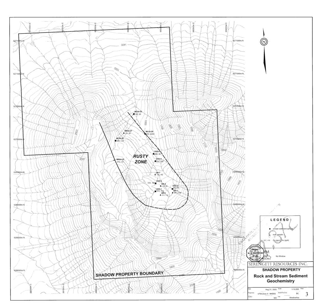
3 SUMMARY The Shadow property covers 80 hectares in mountainous terrain in north-central British Columbia, approximately 20 kilometers northwest of Fort St. James. Access to the property is currently by helicopter, with the nearest road two kilometers to the north of the property. Serengeti is earning a 0 percent in the property. The property is located in the Quesnel Trough which hosts numerous alkalic porphyry copper-gold mines and deposits from southern to northern B.C., in dioritic and monzonitic plugs and stocks. The main ones in the area of the property are the Kemess mine and the Lorraine and Mt.Milligan deposits. In 2004, Serengeti Resources carried out a program of stream sediment sampling and rock sampling. This work confirmed a previous reported stream sediment copper and gold anomaly by the B.C. Regional Geochemical Survey with the anomalous values associated with a zone of pyritic and propylititized andesite and diorite that is at least 1,200m long by 0Om wide. The best rock sample was 997 copper and 1,336ppb gold in a rusty, pyritic, chloritized diorite with epidote veinlets. 1.0 INTRODUCTION The Shadow property was acquired to cover a copper-gold stream sediment anomaly reported from B.C. Regional Geochemical Survey. 2.0 LOCATION AND ACCESS The Shadow property is situated in the Omenica Mining Division just south of Johanson Lake, approximately 20 kilometers northwest of Fort St. James (Plate 1). It is located on NTS map sheet 94D/9, at latitude 6 degrees 32 minutes North and longitude 126 degrees and 2 minutes West and between UTM 68GmE and 68300mE and 62670GmN and 6271OOOmN(NAD 83, Zone 9). The Omenica Mining Road passes two kilometers north of the property with access to the property by helicopter from the Road or the Bergie Camp at the northern end of Johanson Lake. The property is in mountainous terrain with moderate to steep slopes rising from about 1,600m to 2,300m. It is alpine for the most part. 3.0 PROPERTY TITLE The Shadow property consists of two contiguous mineral claims (73hectares, Plate 2) which are owned by Serengeti Resources Inc. Additional records show that Serengeti Resources Inc. has entered into an agreement to earn a 0 percent interest in the Shadow claims from the Mine Match Partnership Ltd.: 3
4
5 SERENGETI RESOURCES INC. CLAIM MAP
6 Shadow March 11, PROPERTY EXPLORATION HISTORY 4.1 Previous Work No previous work has been filed in the assessment records Exploration Program A progam of stream sediment and rock sampling was carried out on the Shadow property on October 1, 2004 to substantiate a stream sediment copper and gold anomaly reported by the B.C. Regional Geochemical survey. This progam was based fiom the Bergie Camp at the north end of Johanson Lake and helicopter supported. A total of eight stream sediment and six rock samples were collected to follow up the anomalous B.C. Regional Geochemical Survey sample..0 REGIONAL GEOLOGY The Shadow property lies in the 1,300km long by 3km wide Quesnel Trough which hosts numerous alkalic porphyry copper-gold deposits fiom southern to northern B.C. In the area of the property the Kemess Mine is located 7km to the northwest while the Lorraine and Mt.Milligan deposits are found 70km and 200km to the southeast respectively. To the west, deformed and uplifted Permian Cache Creek Group rocks are separated fiom Quesnel Trough by the Pinchi fault. To the east, the Manson fault zone separates this belt from the uplifted Proterozoic/early Paleozoic Wolverine metamorphic complex and the Mississippian-Permian Slide Mountain and Cache Creek Groups. In the Johanson Lake area the Takla Group sequence (Quesnel Trough)is dominated by alkalic to subalkalic dark green tuffs, andesitic to basaltic volcanic breccias and flows of similar composition. These volcanic rocks are intruded by syenite, monzonite, monzodiorite and diorite plug and stocks, which are associated with the porphyry coppergold mineralization, and are coeval with the volcanic rocks. 6.0 PROPERTY GEOLOGY The geology of the Shadow property consists of fine gained diorite plugs cutting Takla Group andesite. In the central part of the property a greater than 1,200m long by 0Om wide rusty zone was mapped that shows dioritic plugs and andesite that are variously chloritized and epidotized(some epidote vein1ets)with disseminated and fiacturescontolled pyrite and pyrrhotite. No copper sulfides were observed but must be present to account for the anomalous copper in stream sediment and rock samples. 4
7 7.0 GEOCHEMISTRY The analytical results for copper and gold in stream sediment and rock samples taken are shown in Plate 3 with all the results in Appendix 1.All samples were analyzed in TeckCominco s Global Discovery Labs in Vancouver. The stream sediment samples were taken from the active parts of the stream beds..rock description are in Appendix 2. All the stream sediment samples are anomalous for copper (142 to 333, background less than O from the Regional Geochemical Survey). All but one the samples are anomalous for gold (2Oppb to 2,2OOppb, background less than ppb). Of the six rock samples three are anomalous for copper (217 to 996, background less than 1O) while three are anomalous for gold (2Oppb to 1,336ppb, background less than ppb). The best rock sample was 996 copper and 1,336ppb gold from a chloritized diorite with epidote veinlets and disseminatedfracture-controlled pyrite and pyrrhotite. 8.0 CONCLUSIONS The Shadow property lies in part of the Quesnel Trough that hosts the alkalic porphyry copper-gold Kemess mine and two significant porphyry copper-gold deposits at Lorraine and Mt. Milligan. Serengeti s stream sediment sampling confirms the anomalous copper and gold values reported by the B.C. Regional Geochemical Survey with these anomalies being derived fiom large, rusty, altered zone. The rock types and associated alteration seen are consistent with the type of situation which elsewhere in the Quesnel Trough host important porphyry copper-gold deposits. As the Shadow property has received only very limited, early stage exploration further geological mapping and rock sampling is recommended. Respectfblly submitted, My& Osatenko, P.Geo. Serengeti Resources Inc. Vancouver, British Columbia August, 200
8 APPENDIX 1 ROCK AND STREAM SEDIMENT GEOCHEMICAL RESULTS FOR THE SHADOW PROPERTY Rock Geochemistry Lab No Field No. Au ppb Wt Au gram cu Zn Ag Ba Cd co Ni Fe % Mo Cr Bi R OR-2 <I <.4 18 <I c2 29 c R OR < < R OR <I < R OR-7 c c.4 19 Cl c R MR04-2 <I c c R MR <.4 20 <I < Lab No Field No. Sb v Sn Sr Y Mn MQ % Ti AI Ca Na K % % % % % P R OR-2 < R OR-3 c 32 c R OR- < R OR-7 c oo R MR04-2 < R MR04-27 c Stream Sediment Geochemistry Lab No Field No. AU ppb wt Au gram cu Pb Zn Ag Ba Cd Co Ni Fe % Mo Cr SO4112 oss-1 < <.4 12 < SO OSS <I SO oss c SO oss <I SO oss c.4 4 < SO ML c.4 16 cl SO ML c.4 97 < SO ML c.4 76 Cl
9 Stream Sediment Geochemistry Lab No Field No. Sb V Sn W Sr Y La Mn Mg % Ti Al Ca Na K % % % % % P SO4112 OSS-1 < 122 c SO OSS-4 c SO OSS-6 < SO oss-8 < SO oss-9 E SO ML04-26 c c SO ML04-28 < 61 c SO ML04-29 < ANALYTICAL METHODS: Au Aqua regia decomposition I solvent extraction / AAS Wt Au The weight of sample taken to analyse for gold (geochem) ICP PACKAGE : 0. gram sample digested in hot reverse aqua regia (soi1,silt) or hot Aqua Regia(rocks). ROCK DESCRIPTIONS SarnDle number TvuelLenqth Description OR-2 Grab Rusty andesite. 3%py, chloritized OR-3 Grab Rusty diorite. epidote veinlets, chloritized, 4%py OR- Grab Rusty diorite, epidote veinlets, chloritized, 3%py Rusty diorite, num. ablbite-epidote venlets, chloritized, OR-7 Grab 3%py MR04-2 Grab Rusty diorite, I-2% diss py-po,qtz veinlets MR04-27 Selected chip(l0m) Rusty andesite, tr-2% py-po
10 APPENDIX 2 GEOLOGIST S CERTIFICATE I, Myron Osatenko, of 48 Wildwood Crescent, Delta, B.C., in the Province of British Columbia, DO HEREBY CERTIFY: 1. THAT I am Chief Geologist with Serengeti Resources Inc., a junior mining company. 2. THAT I am a graduate of the University of British Columbia with Bachelor and Master of Science degrees in Honours Geology. 3. THAT I am a Professional Geoscientist registered and good standing with the Association of Professional Engineers and Geoscientists of the Province of British Columbia(#22,12). 4. THAT this report is based on fieldwork carried out be me on October 1,2004 and on publicly- available reports on the Darby property. DATED at Delta, British Columbia, t hisl day of (E?I&rk,
11 APPENDIX 3 STATEMENT OF EXPENDITURES FOR THE SHADOW PROPERTY October 1,2004 8
12
Serengeti Resources Inc GEOCHEMICAL REPORT ON THE DARBY PROPERTY
 Serengeti Resources Inc. 2005 GEOCHEMICAL REPORT ON THE DARBY PROPERTY Located in the Johanson Lake Area Omenica Mining Division NTS 94D/9 56 degrees and 34 minutes North Latitude 126 degrees and 9 minutes
PHYSICAL WORK REPORT. the BAY CLAIMS. Omineca Mining Division Smithers, British Columbia N.T.S. 93E 13E/W
 PHYSICAL WORK REPORT the BAY CLAIMS Omineca Mining Division Smithers, British Columbia a N.T.S. 93E 13E/W LATITUDE: 53 57 00 N I LONGITUDE: 127 45 OO W for Home Ventures Ltd. 1201-675 West Hastings Street
PROSPECTING REPORT THE WALLACE CLAIM OMENICA MINING DIVISION. 54" x6" 3.d d. for. Reako Exlorat ions Ltd. Wallace Rev. C.G.
 PROSPECTING REPORT ON THE WALLACE CLAIM OMENICA MINING DIVISION 54"44 14 1x6" 3.d d by David A. Howard P.Eng. for Reako Exlorat ions Ltd. Claim Locat ion Wallace Rev. C.G. #1560 Dome Mountain Area 9 3
The Cobalt Rainbow. Airborne geophysical maps show that a north trending aeromagnetic high suggests further undiscovered mineralisation.
 The Cobalt Rainbow The property is located on Greenstone Creek, approximately 4.8 kilometres south west of the creek mouth. The property is located about 24 km due west of Campbell River, in the east-central
PRECIOUS METALS. owner. JMT Services Corp. GEOCHPlICAL SAMPLING CHELASLIE WCE, NORTH CENTRAL, B.C. OMINECA MINING DIVISION NTS 93F/5E & 6W
 PRECIOUS METALS REPORT ON 1980 RECONNAISSANCE GEOCHPlICAL SAMPLING CHELASLIE WCE, NORTH CENTRAL, B.C. OMINECA MINING DIVISION NTS 93F/5E & 6W LATITUDE 53O28 N LONGITUDE 125O31 W DATES Qp WORK: JULY 10
GRANGES EXPLORATION AB CANADIAN DIVISION
 GRANGES EXPLORATON AB CANADAN DVSON GEOCHEMCAL REPORT ON "B" and "D" CLAMS OMNECA MNNG DEVSON FAWNE NOSE AREA LATTUDE: 53O 19' LONGTUDE: 125O 1' MNERAL RESOURCES BRANCH N.T.S 93F/6 E Owner and Operator
ASSESSMENT REPORT ON THE PEAVINE PROJECT. DGW & Associates # Alberni Street, Vancouver, British Columbia, V6E 4V2
 ASSESSMENT REPORT ON THE PEAVINE PROJECT KAMLOOPS MINING DIVISION BRITISH COLUMBIA NTS 082M 12 Latitude 51 36' 19.0"North -- Longitude --119 47' 27.0"West UTM Zone 11, NAD 83 5720827N 306744E Prepared
REPORT. on the. Omineca Mining Division, British Columbia. Latitude N., Longitude W. NTS map sheet 93F/7E. James W. McLeod, P.Geo.
 REPORT on the CHU MOLYBDENUM PROPERTY Omineca Mining Division, British Columbia Latitude 53 21 N., Longitude 124 37 W. NTS map sheet 93F/7E James W. McLeod, P.Geo. on behalf of Mr. Chris Delorme TABLE
Daiwan Engineering Ltd Granville strees V.ncouver, B. C. cuudr WY 1GS. M e : (604) PROSPECTING REPORT ON THE KING MINERAL CLAIMS
 PROSPECTING REPORT ON THE KING MINERAL CLAIMS") 1030-609 Granville strees V.ncouver, B. C. cuudr WY 1GS M e : (604) 688-1508 PROSPECTING REPORT ON THE KING MINERAL CLAIMS NORTH VANCOUVER ISLAND, BRITISH COLUMBIA NTS: 92Lj13E Latitude: 50" 47' Longitude:
1030-609 Granville strees V.ncouver, B. C. cuudr WY 1GS M e : (604) 688-1508 PROSPECTING REPORT ON THE KING MINERAL CLAIMS NORTH VANCOUVER ISLAND, BRITISH COLUMBIA NTS: 92Lj13E Latitude: 50" 47' Longitude:
MtNERAL EXPLORATION CONSULTANTS ASSESSMENT REPORT MT. MILLIGAN AREA OMINECA M.D. Latitude: 55' 07' N Longitude: 123" 56' W NTS : 93 0/4 W.
 D. L. COOKE AND ASSOCIATES LTD. MtNERAL EXPLORATION CONSULTANTS ASSESSMENT REPORT 1989 PRELIMINARY GEOCHEMICAL SURVEY KC MINERAL CLAIMS MT. MILLIGAN AREA OMINECA M.D. Latitude: 55' 07' N Longitude: 123"
2013 GEOLOGICAL ASSESSMENT REPORT SHERIDAN HILL PROPERTY
 2013 GEOLOGICAL ASSESSMENT REPORT ON THE SHERIDAN HILL PROPERTY NEW WESTMINSTER MINING DIVISION BRITISH COLUMBIA NTS 092G07 49 16 31 NORTH LATITUDE, 122 39 48 WEST LONGITUDE PREPARED FOR Sheridan Hill
GOLDCLIFF TULAMEEN PORPHYRY COPPER PROJECT COPPER MOUNTAIN CAMP, BRITISH COLUMBIA THE TROJAN-CONDOR COPPER TARGET HIGHLIGHTS
 Suite 350-885 Dunsmuir Street PF 250 764 8879 TF 866 769 4802 Vancouver, BC, Canada FX604 261 8994 info@goldcliff.com V6C 1N5 GCN.TSXV www.goldcliff.com GOLDCLIFF TULAMEEN PORPHYRY COPPER PROJECT COPPER
The McPhillamys Gold Deposit, Discovery History & Geology. Presenter: Tara French
 The McPhillamys Gold Deposit, Discovery History & Geology. Presenter: Tara French Forward-Looking Statements This presentation contains forward-looking statements. without limitation: Estimates of future
1 CLAIMS GEOPHYSICAL REPORT ON BOYAL SITUATE NORTHEAST OF TILLICUM MOUNTAIN GOLD AREA BURTON - NAKUSP SIQCAEJ MINING DIVISION
 GEOPHYSICAL REPORT ON BOYAL 1 CLAIMS SITUATE NORTHEAST OF TILLICUM MOUNTAIN GOLD AREA BURTON - NAKUSP SIQCAEJ MINING DIVISION CONSULTING GEOLOGIST AUGUST 1983 VANCOUVER B *C INDEX INTRODUCTION ooa,.eoaaa.aaaoaaooaoa~ao~o
GEOPHYSICAL REPORT ON THE PRINCE GEORGE PORPHYRY PROJECT LYNX PROPERTY
 GEOPHYSICAL REPORT ON THE PRINCE GEORGE PORPHYRY PROJECT LYNX PROPERTY Lynx Property Omenica Mining Division British Columbia Tenure # 841107, 742942, 741962 NTS Sheet 093K MTO Event Number - 5434711 UTM
Mineral Claims. Aspen Grove Area Nicola Mining Division, British Columbia. Latitude N., Longitude W. NTS Map Sheet 92H/lSE
 Mineral Claims Aspen Grove Area Nicola Mining Division, British Columbia Latitude 49 51 N., Longitude 120 35 W. NTS Map Sheet 92H/lSE James P. Balmer, B.SC., P.Geo. on behalf of Gary Brown November 26,2003
UNION MINIERE EXPLORATIONS AND MINING CORPORATION LIMITED ASSESSMENT REPORT ON FITINAT MINERAL CLAIM. Alberni Mining Division Record No.
 M F )( UNION MINIERE EXPLORATIONS AND MINING CORPORATION LIMITED Suite 200, 4299 Canada Way, Burnaby, B.C. V5G 1 H4 Telephone (604) 437-9491 ASSESSMENT REPORT ON GEOCHEMICAL SOIL SURVEYS AND ROCKSAMPLING
News Release No GOLD AND COPPER MINERALIZATION DISCOVERED DURING PHASE 2 EXPLORATION AT THE MCBRIDE PROPERTY
 November 19, 2018 TSX Venture Exchange Listed Frankfurt Exchange Listed News Release No. 303-2018 GOLD AND COPPER MINERALIZATION DISCOVERED DURING PHASE 2 EXPLORATION AT THE MCBRIDE PROPERTY Vancouver,
Lat. 52' 43' N Long ' W
 &A exploration ltd MINING ENGINEERING GEOLOGY- GEOPHYSICS 4570 HOSKINS ROAD, NORTH VANCOUVER, 6. C. TELEPHONE (804) 985,7921 V7K 2R1 GEOLOGICAL AND GEOCHEMICAL REPORT on the BLUE CLAIMS Cariboo Mining
A New Direction. Copper-Gold Deposit at Thor TSX.V:COL. August 11, May 2013
 A New Direction Copper-Gold Deposit at Thor August 11, 2016 May 2013 TSX.V:COL FORWARD LOOKING STATEMENTS This presentation includes certain forward-looking information or forward-looking statements for
GEOLOGY AND LITHOGEOCHEMISTRY OF THE CHILKO-TASEKO LAKES AREA* BY G.
 B Ministry of Energy, Mines and Petroleum Resources GEOLOGICAL BRANCH MINERAL RESOURCES DIVISION NOTES TO ACCOMPANY OPEN FILE - GEOLOGY AND LITHOGEOCHEMISTRY OF THE CHILKO-TASEKO LAKES AREA* BY G. P. McLAREN
PROSPECTORS ASSISTANCE PROGRAM MINISTRY OF ENERGY AND MINES
 BRITISH COLUMBIA PROSPECTORS ASSISTANCE PROGRAM MINISTRY OF ENERGY AND MINES GEOLOGICAL SURVEY BRANCH PROGRAM YEAR: 1999/2000 REPORT #: PAP 99-l 6 NAME: KIM ANSCHETZ PROSPECTORS TlEPORT on the 99 LOUIS
GEOCHEMICAL STREAM SAMPLING. on the PLACER LEASES NO. Jordan River/Bear Creek Area. Victoria Mining Division. Latitude 48 degrees 32 minutes N.T.S.
 GEOCHEMCAL STREAM SAMPLNG on the PLACER LEASES NO P. 8149, 8150, 8151, 8152, 8161, 8162, 8163, 8400, 10844, 10845 Jordan River/Bear Creek Area Victoria Mining Division Latitude 48 degrees 32 minutes Longitude
Structural Analysis Using Hillshade Imagery. on the. LLC Property
 Structural Analysis Using Hillshade Imagery on the LLC Property Liard Mining Division NTS 104F/16W Latitude: 57 53' 47'' N Longitude: 132 03' 06'' W Owner Garry John Payie 3714 Raymond Street South, Victoria,
BLURTON CREEK NICKEL PROPERTY. (Minfile # 082LNW-039)
") 5489153 BLURTON CREEK NICKEL PROPERTY (Minfile # 082LNW-039) Mara Lake Area / Salmon Arm B.C NTS - 82L-11 (UTM 83/Z10, 357690E, 5614220N) Prepared by: Jim Cuttle, B.Sc., P.Geo. 86 Cloudburst Road Whistler,
5489153 BLURTON CREEK NICKEL PROPERTY (Minfile # 082LNW-039) Mara Lake Area / Salmon Arm B.C NTS - 82L-11 (UTM 83/Z10, 357690E, 5614220N) Prepared by: Jim Cuttle, B.Sc., P.Geo. 86 Cloudburst Road Whistler,
MAYO LAKE MINERALS INC
 MAYO LAKE MINERALS INC FOR IMMEDIATE RELEASE Press release 2014-05 Gold-Arsenic-Antimony Anomalies on Anderson Claim Group Follow-up Sampling on Davidson, Edmonton and Roop Claim Groups OTTAWA, ONTARIO,
Timberline Completes Technical Reports on the Elder Creek and Paiute Porphyry Copper-Gold Projects, Nevada
 FOR IMMEDIATE RELEASE Timberline Completes Technical Reports on the Elder Creek and Paiute Porphyry Copper-Gold Projects, Nevada Coeur d Alene, Idaho November 29, 2018 Timberline Resources Corporation
for the Greenwood Mining Division, B.C. NTS 82E/7W Latitude 49' 27' W, Longitude 118' 5 Prepared by a= D. Dylan Watt, B.Sc.
 t. b LOGnO: 37~ -08 m. ACTIO#: for the AMP AMP 2 AMP 3 t AMP 4 CLAIMS Greenwood Mining Division, B.C. NTS 82E/7W Latitude 49' 27' W, Longitude 8' 5 %E c,w zc *& a w Prepared by a= -4c. D. Dylan Watt, B.Sc.
Elephant Mountain, Alaska Intrusive Related Gold Project July Option to Earn 100%
 Elephant Mountain, Alaska Intrusive Related Gold Project July 2018 Option to Earn 100% CORPORATE Corporate DISCLOSURE Disclosure The information contained herein, while obtained from sources which we believe
Pacific Empire Minerals Provides Copper King RC Drilling Results
 Pacific Empire Minerals Provides Copper King RC Drilling Results November 1, 2018 - Vancouver, BC, Canada - Pacific Empire Minerals Corp. (TSXV: PEMC) ( Pacific Empire, PEMC or the Company ), a hybrid
GEOLOGICAL MAPPING REPORT ON THE ASH MINERAL CLAIM OSOYOOS MINING DIVISION ASHNOLA RIVER MAP SHEET NTS M092,H019 MCBRIDE CREEK AREA, ASHNOLA RIVER,
 GEOLOGICAL MAPPING REPORT ON THE ASH MINERAL CLAIM OSOYOOS MINING DIVISION ASHNOLA RIVER MAP SHEET NTS M092,H019 LATITUDE 49 o O6, LONGITUDE 120 o 22 MCBRIDE CREEK AREA, ASHNOLA RIVER, KEREMEOS, B.C. CANADA
SECOND and THIRD YEAR ASSESSMENT REPORT PROSPECTING LICENCE M, ROCK CUT PROPERTY, NTS 1N/12, NEWFOUNDLAND. ROY FRENCH (licence holder )
") SECOND and THIRD YEAR ASSESSMENT REPORT Of PROSPECTING On LICENCE 013704M, ROCK CUT PROPERTY, NTS 1N/12, NEWFOUNDLAND. By ROY FRENCH (licence holder ) Work Conducted: Sept. 17, 2008 Nov. 03, 2009 Total
SECOND and THIRD YEAR ASSESSMENT REPORT Of PROSPECTING On LICENCE 013704M, ROCK CUT PROPERTY, NTS 1N/12, NEWFOUNDLAND. By ROY FRENCH (licence holder ) Work Conducted: Sept. 17, 2008 Nov. 03, 2009 Total
49" 3-4 I4 I \ Y 59 tj
 ASSESSMENT REPORT Mary 4 FORT STEELE M.D. NTS 82G/5W 49" 3-4 4 \ Y 59 tj Owner: St. Eugene Mining Corporation Limited Operator : St. Eugene Mining Corporation Limited Author: John R. Wilson Date Submitted:
REPORT ON A GEOLOGICAL MAPPING AND PROSPECTING PROGRAM LOOK PROPERTY
 b KOKANEE EXPLORATIONS LTDI I WNO. 0 I- n c/ REPORT ON A GEOLOGICAL MAPPING AND PROSPECTING PROGRAM LOOK PROPERTY LOOK 1-31, 36-43 CLAIMS FORT STEELE MINING DIVISION CRANBROOK AREA N.T.S. 82G/5W + 4E E:
TOPOGRAPHICAL SURVEY REPORT ON THE GREENDROP PROPERTY NEAR CHILLIWACK, B.C. 92-H-3/W
 TOPOGRAPHICAL SURVEY REPORT ON THE GREENDROP PROPERTY NEW WESTMINSTER M.D. NEAR CHILLIWACK, B.C. 92-H-3/W Location: The central pap of the claims is located at coordinates 49 08'N, latitude by 121 26'W,
PIOTR LUTYNSKI VANCOUVER, BRITISH COLUMBIA
 AN ASSESSMENT REPORT ON GROUND MAGNETIC SURVEYING CHUCHI PROPERTY FORT ST. JAMES AREA, BRITISH COLUMBIA OMINECA M.D. 55 17 N, 124 31 W NTS 93N/ 7&8 Claims Surveyed: 597976, 597878-597880 Survey Dates:
BALFOUR MINING LTD. (N.P.L.) HAM GROUP 92-P-6, CLINTON M. D.8 B. C. Lat 51 17'N, GEOCHEMICAL REPORT. V. CUKOR, P. Eng.
 HAM GROUP 92-P-6, CLINTON M. D.8 B. C. Lat 51 17'N, GEOCHEMICAL REPORT. V. CUKOR, P. Eng.") 34q '7 BALFOUR MINING LTD. (N.P.L.) HAM GROUP 92-P-6, CLINTON M. D.8 B. C. Lat 51 17'N, Long 12lo14'W GEOCHEMICAL REPORT, V. CUKOR, P. Eng. January 31, 1972 TABLE OF CONTENTS 1. INTRODUCTION 2. PROPERTY,
34q '7 BALFOUR MINING LTD. (N.P.L.) HAM GROUP 92-P-6, CLINTON M. D.8 B. C. Lat 51 17'N, Long 12lo14'W GEOCHEMICAL REPORT, V. CUKOR, P. Eng. January 31, 1972 TABLE OF CONTENTS 1. INTRODUCTION 2. PROPERTY,
for the Greenwood Mining Division, B.C. NTS 82E/7W 29' W, Longitude 118' 53' N Prepared by D. Dylan Watt, B.Sc.
 for the FltE NO: u VOLT 1, VOLT 2, VOLT 3, & VOLT 4 CLAIMS Greenwood Mining Division, B.C. NTS 82E/7W Latitude 49' 29' W, Longitude 118' 53' N Prepared by D. Dylan Watt, B.Sc. #309-1996 Trutch Street Vancouver,
EXPLOR INTERSECTS MULTIPLE COPPER ZONES GRADES UP TO 3.65% CU OVER 5.35 METERS ON THE CHESTER COPPER PROPERTY
 15 Gamble East Street - Suite 204 - Rouyn-Noranda (Canada) J9X 3B6 Listing (TSX-V = EXS) (OTCQB = EXSFF) (FSE & BE = E1H1) EXPLOR INTERSECTS MULTIPLE COPPER ZONES GRADES UP TO 3.65% CU OVER 5.35 METERS
Beekeeper Property The Geology South of Mint Lake. Cariboo Mining Division
 Beekeeper Property The Geology South of Mint Lake NTS: 93A/6 Cariboo Mining Division Claims: Beekeeper 1 #I2055 Beekeeper 2 #3892 Beekeeper 3 #7895 Beekeeper 4 #8503 Latitude: Longitude: 52 degrees 24
The survey covered claims, in part or in full, DUCKLING 3, 4, 5, 4 fraction, and 5 fraction.
 514 687-6671 XXX- 602 West Hastin~a StroeP, Vata;sn@ouver, BritlsA fhlum~b~a, Garaadsa B81apphgtaa DISCUSS ION OF MAGNETOMETER SURVEY ON DUCKLING CLAIMS FOR DONNA MINES LTD. (N0P.L.) Submitted to: DONNA
CONSULTING GEOLOGICAL 8: MINING ENGINEERS STINGS STREET DA V6E 2E9 GEOPHYSICAL SURVEY SILVER QUEEN 2 ZEBALLOS AREA. B.C.
 DOLMAGE CAMPBELL & ASSOCIATES (1 975) LTD. CONSULTING GEOLOGICAL 8: MINING ENGINEERS STINGS STREET DA V6E 2E9 '' 1E O L 0 G I C A.L B'x;&a:f2:#& 'SESSMENT REPObT 12, Assessment RESOURCES LTD. 111 ReDort
NTS 93L/9W GEOCHEMICAL AND GEOPHYSICAL REPORT MONA CLAIM OMINICA MINING DIVISION. Lati tude 54036'N; Longitude 'W
 GEOCHEMICAL AND GEOPHYSICAL REPORT ON MONA CLAIM OMINICA MINING DIVISION Lati tude 54036'N; Longitude 126018'W NTS 93L/9W April 1981 Paul Plicka Consulting Geologist LOCATION MAP INTRODUCTION TABLE OF
CAMBRIAN INTRUSION-RELATED COPPER MINERALISATION AT THE THOMAS CREEK PROSPECT, SOUTHWESTERN TASMANIA
 CAMBRIAN INTRUSION-RELATED COPPER MINERALISATION AT THE THOMAS CREEK PROSPECT, SOUTHWESTERN TASMANIA UN I VF.RS TTY OF TASMANIA By Robert Reid (B.Sc. Hons) A thesis submitted in partial fulfillment of
DSM SYNDICATE DISCOVERS POLYMETALLIC MINERALIZATION WITH TALUS GRAB SAMPLES CONTAINING UP TO PERCENT LEAD AND 18
 DSM SYNDICATE DISCOVERS POLYMETALLIC MINERALIZATION WITH TALUS GRAB SAMPLES CONTAINING UP TO 92.8 GRAMS PER TONNE GOLD, 13,643 GRAMS PER TONNE SILVER, 13.85 PERCENT LEAD AND 18.65 PERCENT COPPER FROM DIFFERENT
CHIVAS A New Large Scale Au-Ag-Te-Cu Target
 Northwest British Columbia April 4, 2017 CHIVAS A New Large Scale Au-Ag-Te-Cu Target The Kamloops Exploration Group 2017 30 YEARS OF DISCOVERY 1 Gary R. Thompson, P.Geo. SAFE HARBOUR STATEMENT Information
..!I AXE CLAIMS ON THE. for RICHCORE EXPLORATIONS LTO. GREENWOOD MINING DIVISION BRITISH COLUMBIA. Latitude 49O 30"; Longitude 118' 30'W NTS 82E/9W
 ON THE AXE CLAIMS for RICHCORE EXPLORATIONS LTO. GREENWOOD MINING DIVISION BRITISH COLUMBIA Latitude 49O 30"; Longitude 118' 30'W NTS 82E/9W... -... ~ i.,...._.'..!i Vancouver, B.C. September, 1980 P.
RECONNAISSANCE GEOCHEMICAL SURVEY
 RECONNAISSANCE GEOCHEMICAL SURVEY LEGAL, RITA, LOUISE FR. (CHAPLEAU GROUP) REVERTED CROWN GRANTS CHAPLEAU CREEK AREAJ, SLOC& MINING DIVISION 82 F/11W Lat: 49'44" Long: 117"22'W MINERAL RESOURCES BRANCH
R.A. COMINCO LTD. EXPLORATION NTS: 92H/16. WESTERN DISTRICT January 6, 1982 ASSESSMENT REPORT 1981 SOIL GEOCHEMISTRY ON THE TROUT PROPERTY
 COMINCO LTD. EXPLORATION NTS: 92H/16 WESTERN DISTRICT January 6, 1982 ASSESSMENT REPORT 1981 SOIL GEOCHEMISTRY ON THE TROUT PROPERTY (Trout 1 and 6 Claims) SIWASH LAKE AREA, SIMILKAMEEN M.D., B.C. (Work
Seafield Announces the Discovery of a New Porphyry-Style Drill Target at its Quinchía Gold Project in Risaralda, Colombia
 For Immediate Release Seafield Announces the Discovery of a New Porphyry-Style Drill Target at its Quinchía Gold Project in Risaralda, Colombia Toronto, Ontario, September 27, 2012 - Seafield Resources
1 FILMED 1. FILE NO:!..rsrru -* -. GRAND TWO CLAIM
 FILE NO:!..rsrru -* -. GRAND TWO CLAIM REPORT ON 1993 ASSESSMENT WORK GRAND TWO CLAIM REC. NO. 301849 NELSON MINING DIVISION NTS MAP SHEET 82F6/W 49 25'51" NORTH 117 18'08" WEST 1 FILMED 1 AUTHOR: R. Jordan,
Project Copper CBC. Bahia Brazil -August
 Project Copper CBC Bahia Brazil -August - 2016 The Company The CBC Mineração Ltda is a company of BETONITA group created to develop this project copper. It s a solid group in the brasilian market very
Geology of Quesnel and Stikine terranes and associated porphyry deposits. Jim Logan Paul Schiarizza
 Geology of Quesnel and Stikine terranes and associated porphyry deposits Jim Logan Paul Schiarizza Quesnel and Stikine terranes Major cordilleran terranes characterized by similar Late Triassic Early Jurassic
7 miles West of Kamloops, B.C.
 MINERAL RESOURCES BRANCH ASSEWAENT RiPORT of hole # 78-11 NO. drilled on the ZZ # 18 Claim of China Commercial Corporation Ltd situated 7 miles West of Kamloops, B.C. in the Kamloops Mining Division D.R.
SOIL GEOCHEMISTRY. OK-ll AND OK-Ill MINERAL CLAIMS MOUNT THOEN AREA OMINECA MINING DIVISION, B.C. NTS 93 MI6 E & 7 W
 SOIL GEOCHEMISTRY OK-ll AND OK-Ill MINERAL CLAIMS MOUNT THOEN AREA OMINECA MINING DIVISION, B.C. NTS 93 MI6 E & 7 W LATITUDE 55O23'N, LONGITUDE 127 01W Locke B. Goldsmith, P.Eng. Consulting Geologist December
Rich Saddle North Au-Cu-Ag Porphyry Expands by 275m Along Strike and 250m Down-Dip
 GT Gold Drills 281 Metres of 0.65 g/t Au, 0.38% Cu, 1.38 g/t Ag (1.24 g/t AuEq 1 ) Within 685 Metres 2 of 0.40 g/t Au, 0.26% Cu, 1.03 g/t Ag (0.81 g/t AuEq) in Step-out Hole TTD098 Rich Saddle North Au-Cu-Ag
TERA 1-4; reccrd no s Clifford McNeill TENA 5-10; record no s Owner: lrnest G. Olfert
 GEOCHENIC-:-I, SURVEY REPORT ON MINXAL CLAIMS TERA 1-4; reccrd no s 9107-9110 Owner: Clifford McNeill TENA 5-10; record no s 9399-9404 Owner: lrnest G. Olfert Located in the Orineca Mining Division of
BGND 2-7 CLAIMS, KELOWNA, B.C.
 GEOLOGICAL EVALUATION of BGND 2-7 CLAIMS, KELOWNA, B.C. 5"'33"N; 9"33'3"W:NTS 82L/4E BEAR CREEK: 4Km NNW of Kelowna Vernon Mining Div., British Columbia by N. C., P.Geol., P. Eng. Consulting Geologist,
NTS 082F03SW N W U E N
 Prospecting Report JOCELYN CLAIM NTS 082F03SW N49 09 51 W 117 14 04 11U 482906E 5445737N NELSON MINING DIVISION Martin Ross PO Box 323 Salmo BC V0G 1Z0 Jan 31, 2012 PROSPECTING REPORT JOCELYN MINERAL CLAIM
ASSESSMENT REPORT. Geochemical and Geological Surveys. on the. Gooch#1-4. Mineral Claims. Omenica Mining District NTS 93L/7W
 f- GEOLOGICAL BRANCH ASSESSMENT REPORT ASSESSMENT REPORT Geochemical and Geological Surveys on the Gooch#1-4 Mineral Claims Omenica Mining District NTS 93L/7W LAT: 54O25'W LONG: 126O26'W Operator: SMD
Northern Chile, 85 Km NE of La Serena 125 km S of Relincho (Nueva Union Teck-Goldcorp)
") July 2017 Mirador lies along the southern extensions of the highly productive Paleocene Mineral Belt in northern Chile that contains numerous important copper, gold and silver mines and projects. Mirador
July 2017 Mirador lies along the southern extensions of the highly productive Paleocene Mineral Belt in northern Chile that contains numerous important copper, gold and silver mines and projects. Mirador
sq N & %%.& GEOPHYSICAL CONSULTING rr SERVICES LTD. $%& Long. 118o3OtW N.T.S. 82 E/15 -I- AUTROR: Glen E. Whi*e, B.Sc., P. %g.
 -\ GEOCHEMICAL EXPORT.,~.,~..'.. AMORE MINERALS 1NCORPOR;ITZC,' ~. 3rd fl5 Geo 3. and 2 mineral claims, Vernon- ~ $lining Division, B. C. Lat. 49 47'T?,,/ Long. 118o3OtW N.T.S. 82 E/15 -I- AUTROR: Glen
First Year assessment Report on Prospecting and Rock sampling, King George property, License M NTS 12A/05 Newfoundland and Labrador.
 First Year assessment Report on Prospecting and Rock sampling, King George property, License 016679M NTS 12A/05 Newfoundland and Labrador. Submitted by Shawn Rose For Shawn Rose January 2011 Work year
REPORT SOIL GEOCHEMICAL SURVEY. ATTYCELLEY NO. 2 GROUP (Attycelley Mineral Claims No. 7-10)
") REPORT SOIL GEOCHEMICAL SURVEY ATTYCELLEY NO. 2 GROUP (Attycelley Mineral Claims No. 7-10) Situated 7 miles east of north end of Thutade Lake, Omineca Mining Division British Columbia I Department of I
REPORT SOIL GEOCHEMICAL SURVEY ATTYCELLEY NO. 2 GROUP (Attycelley Mineral Claims No. 7-10) Situated 7 miles east of north end of Thutade Lake, Omineca Mining Division British Columbia I Department of I
COMMANDER RESOURCES LTD.
 COMMANDER RESOURCES LTD. October Dome Gold Skarn Mt Polley Core Facility February 2016 1 August 2016 CORPORATE DISCLOSURE Disclaimer The information contained herein, while obtained from sources which
Goliath Reports Grams Per Tonne Gold Equivalent Over 2 Metres Channel Cut at Golddigger in the Golden Triangle; Bulk Sample Recommended
 Goliath Reports 22.83 Grams Per Tonne Gold Equivalent Over 2 Metres Channel Cut at Golddigger in the Golden Triangle; Bulk Sample Recommended November 28, 2017 Goliath Resources Ltd. (TSX-V: GOT) (the
121 deg 44' W and 53 deg 07' N
 M.R. #. R... VANCOUVER, B.C. REPORT ON THE WILLOW AND WILLOW I CLAIMS RECORD NO. 8475 AND 8476 CARIBOO MINING DIVISION NTS 93 H/4 121 deg 44' W and 53 deg 07' N 'W OWNER AND OPERATOR: RUZA RESOURCES LTD.
GEOCHEMICAL REPORT. Skeena M.D. Latitude Longitude G-4Yd N.T.S. September 18-29, 1979
 GEOCHEMCAL REPORT On the QCSZ Claims Group (Snow #3 64 Claims) Skeena M.D. Latitude 53 13 Longitude 131 49 N.T.S. 103-G-4Yd September 18-29, 1979 Vancouver, B. C. January, 1980 S. Zastavnikovich TABLE
FOLLOW-UP GEOCHEMICAL REPORT ON THE PM CLAIM OMINECA MINING DIVISION N.T.S. 93 5/ degrees 123 degrees
 FOLLOW-UP GEOCHEMICAL REPORT ON THE PM CLAIM OMINECA MINING DIVISION N.T.S. 93 5/3 PO mm w o Latitude: Longitude: 54 degrees 3 degrees 59" 44'W NORANDA EXPLORATION COMPANY, LIMITED (NO PERSONAL LIABILITY)
ASSESSMENT REPORT TITLE PAGE AND SUMMARY
 ASSESSMENT REPORT TITLE PAGE AND SUMMARY TITLE OF REPORT: Assessment Report on Andys Bridge Mineral Claim, Turnagain River Area TOTAL COST: $2,100 AUTHOR(S): Bruce w Downing SIGNATURE(S): Bruce W Downing
AND HORSEFLY PROSPECTS, N.W. BRITISH COLUMBIA NTS, 103H/ll, 14 FOR ATNA RESOURCES LTD DELTA GEOSCIENCE LTD
 AND HORSEFLY PROSPECTS, N.W. BRITISH COLUMBIA NTS, 103H/ll, 14 FOR ATNA RESOURCES LTD BY DELTA GEOSCIENCE LTD FE T A. HENDRICKSON, P.GEO. 1 . TABLE OF CONTENTS Introduction............. Page 1. Personnel..........
REPORT ON DIAMOND DRILLING SUBSTITUTION EAST PROPERTY CLAIMS AND HEBERT TOWNSHIP ONTARIO, CANADA
 REPORT ON DIAMOND DRILLING SUBSTITUTION EAST PROPERTY CLAIMS 1248920 AND 1248921 HEBERT TOWNSHIP ONTARIO, CANADA Adroit Resources Inc. Suite #610-1111 Melville Street Vancouver, British Columbia, Canada
VANCOUVER, B.C. Tri 082F/ F/059
 GEOCHEMCAL REPORT t MAY L, 2006 Whbpper Mineral Claims Ailsa Lake Area Gold comm~ss16fl8f"s Offim on Mining Division VANCOUVER, B.C. Tri 082F/058 082F/059 3792 E 5486438 N Operator Kootenay Gold nc. Suite
For personal use only
 22 June 2012 The Manager ASX Announcements NEW SURVEY DEFINES PRECIOUS & BASE METAL PROSPECTS ON SA s NORTHERN EYRE PENISULA A suite of new epithermal gold, silver and base metals prospects has been defined
SALAZAR REPORTS OUTCROPPING GOLD MINERALIZATION AT RUMIÑAHUI, ECUADOR
 #1305-1090 West Georgia Street Vancouver, BC Canada V6E 3V7 Tel: (604) 685-9316 Fax: (604) 683-1585 TSX Venture Exchange: SRL Frankfurt Stock Exchange: CCG NEWS RELEASE MAY 25, 2007 SALAZAR REPORTS OUTCROPPING
COMINCO LTD. HORIZONTAL LOOP EM AND MAGNETIC SURVEYS ON SHA. CLAIMS 1, 2, 7 and 8 NELSON AND FORT STEELE MINING DIVISIONS, B.C.
 COMINCO LTD. EXPLORATION WESTERN DISTRICT NTS: 82-F/1 HORIZONTAL LOOP EM AND MAGNETIC SURVEYS ON SHA CLAIMS 1, 2, 7 and 8 - ASSESSMENT REPORT - NELSON AND FORT STEELE MINING DIVISIONS, B.C. Latitude Longitude
GEOCSZNICAL - SURVEY. ICAMLOOPS Kl.D. 2'' 6;kr. HY "'f. Alfred R. Allen,P.Eng. 1 NO.%=...,... 6"- 'I.
 t i.i GEOCSZNICAL - SURVEY i p' ICAMLOOPS Kl.D. 2'' 6;kr HY 50-64 +."'f 121-51 NE 5-10-70 : 19-10-70 Alfred R. Allen,P.Eng. I) ' 1 6"- 'I. 1 NO.%=...,..... Q.C. EXPLORATIONS LTD. 2Cl- 535 Kowe Street Vancouver
LINGIG PORPHYRY COPPER DISCOVERY
 MEDUSA MINING LIMITED ABN: 60 099 377 849 Unit 7, 11 Preston Street Como WA 6152 PO Box 860 Canning Bridge WA 6153 Telephone: 618-9367 0601 Facsimile: 618-9367 0602 Email: admin@medusamining.com.au Internet:
National Geochemical Reconnaissance Surveys in the BC Cordillera Identify New Mineral Exploration Targets
 National Geochemical Reconnaissance Surveys in the BC Cordillera Identify New Mineral Exploration Targets By Ray Lett 1 and Peter Friske 2 KEYWORDS: Geochemistry, mineral exploration, multi-element, stream
NEW HAZELTON, OMINECA M.D.,
 PROSPECTING REPORT JUDI 1 TO 6 MINERAL CLAIMS NEW HAZELTON, OMINECA M.D., B.C. MAP 93M/4E, LAT. SS014'N, LONG. 127'33'W OWNED BY: A. L'ORSA ANTHONY L'ORSA Smithers, B.C. 21 February, 1981 TABLE OF CONTENTS
Jedway Enterprises Ltd st Ave, Surrey, BC V3S 3M3
 Jedway Enterprises Ltd. 104-19286 21 st Ave, Surrey, BC V3S 3M3 Prospecting Report on the Den (Den#1 to #4) Property, Takla Landing Area, Omineca Mining Division, British Columbia NTS 93N/12 Trim 093N052,093N062
3. GEOLOGY. 3.1 Introduction. 3.2 Results and Discussion Regional Geology Surficial Geology Mine Study Area
 3. GEOLOGY 3.1 Introduction This chapter discusses the baseline study of the geology and mineralization characteristics of the mine study area. The study consolidates existing geological data and exploration
490 20' 30" North Latitude ' 30" West Longitude
 _._.. I CONSULTING GEOLOGISTS 605-602 WEST HASTINGS STREET, VANCOUVER, B.C. V6B 1P2 TELEPHONE: (604) 689-5533 6 I F: ASSESSMENT REPORT ON THE PATSY 1 MINERAL CLAIM ' '?%2% I WHISTLE CREEK, HEDLEY ARE L-l-
BIOGEOCHEMISTRY Discovery Using Metal Concentrations in Plants Mule Canyon Mine Introduction
 Mule Canyon Mine BIOGEOCHEMISTRY Discovery Using Metal Concentrations in Plants Shea Clark Smith /MEG, Inc. P.O. Box 18325 Reno, Nevada 89511 www.sheaclarksmith.com SheaClarkSmith@aol.com Copyright: Shea
Prospecting Report 'S Office i DB Property, B.C. -J Negro Creek Nelson Mining District NTS 82F.050. Operator: Kootenay Gold Inc.
 . '.' I"' i9 12 Prospecting Report 'S Office i DB Property, B.C. -J Negro Creek Nelson Mining District NTS 82F.050 Operator: Kootenay Gold Inc. Owner: Darlene Lavoie Work Performed Summer of 2007 Report
Lustdust Introduction
 Lustdust Introduction N 126º 18 W Kemess Cirque Akie 230kV POWER LINE BEAR LAKE 56º 22 N Sustut Williston Lake CN. RAIL Lorraine 29 Lustdust TAKLA LANDING Kwanika GERMANSEN LANDING MACKENZIE Bell Granisle
'-7' REPORT ON A MAGNETOMETER SURVEY OVER PART OF THE MAX CLAIM GROUP 1-20 LAC LE JEUNE AREA KAMLOOPS MINING DIVISION KAMLOOPS, BRITISH COLUMBIA
 I,., - SUITE 102. 222 BELLEVUE WES t ANCOUVER, B. '-7' REPORT ON A I MAGNETOMETER SURVEY OVER PART OF THE MAX CLAIM GROUP 1-20 LAC LE JEUNE AREA KAMLOOPS MINING DIVISION KAMLOOPS, BRITISH COLUMBIA 50-30
BCGold Corp. Discovery Driven
 BCGold Corp. Discovery Driven Sickle-Sofia Property Copper-Gold Porphyry Discovery in the Toodoggone Camp! Cautionary Statement This presentation does not constitute an offer to sell or solicitation of
ASSESSMENT REPORT TITLE PAGE AND SUMMARY
 ASSESSMENT REPORT TITLE PAGE AND SUMMARY TITLE OF REPORT: Assessment Report on An Induced Polarization, Lac La Hache, in the Lac La Hache area, westcentral British Columbia Clinton Mining Division TOTAL
Bellhaven Adds Gold at the El Limon Target at the La Mina Project, Colombia
 Bellhaven Adds Gold at the El Limon Target at the La Mina Project, Colombia Denver, Colorado December 27, 2012. Bellhaven Copper & Gold Inc. (TSX-Venture: BHV) ( Bellhaven or the Company ) is pleased to
ASSESSMENT REPORT GEOLOGICAL BRANCH. 50' 23 'North. GEOLOGICAL and GEOCHEMICAL SURVEYS ON THE. PUTNAM PROPERTY (Putnam Mineral Claim)
") GEOLOGICAL and GEOCHEMICAL SURVEYS ON THE PUTNAM PROPERTY (Putnam Mineral Claim) VERNON MINING DIVISION, B.C. GEOLOGICAL BRANCH ASSESSMENT REPORT NTS : Latitude: 82L17W 50' 23 'North LOCATION, ACCESS,
GEOLOGICAL and GEOCHEMICAL SURVEYS ON THE PUTNAM PROPERTY (Putnam Mineral Claim) VERNON MINING DIVISION, B.C. GEOLOGICAL BRANCH ASSESSMENT REPORT NTS : Latitude: 82L17W 50' 23 'North LOCATION, ACCESS,
June 24 and From August 26 to September 13, 1969
 e GEOLOGCAL REPORT June 24 and From August 26 to September 13, 1969 on THE GARNET CLAM GROUP TOODOGGONE RVER AREA (N. T. S. 94E) OMNECA MNNG DVSON, BRTSH COLUMBA 57' 28' N latitude, 126" 55' W longitude
vox 1wo LOG NO: SEP 1 019% RD. &CTlON. JG-1, PILOT GOLD, PILOT GOLD 1 h 2. AND GOLD WING 1 TO 6 CLAIMS for HAROLD ADAMS Box 1329 Princeton, B.C.
 LOG NO: SEP 1 019% RD. &CTlON. JG-1, PLOT GOLD, PLOT GOLD 1 h 2. AND GOLD WNG 1 TO 6 CLAMS r Weyrnan Creek Area Kamloops Mining Division 82L-5W (50O22' N. Lat., 119O59' W. Long.) for HAROLD ADAMS Box 1329
ASSESSMENT REPORT PROSPECTING PROGRAM ION/DIRTY JACK PROPERTY NELSON MINING DIVISION N.T.S. MAP SHEET 82F.023 UTM COORDINATES N E
 ASSESSMENT REPORT PROSPECTING PROGRAM ION/DIRTY JACK PROPERTY NELSON MINING DIVISION N.T.S. MAP SHEET 82F.023 UTM COORDINATES 5454800N - 0455235E Work Performed Summer 2007 OWNER >* ' Tom Kennedy >8 404-22
GEOCHEMICAL AND PROSPECTING REPORT. RC ly 2,3,4 CLAIMS
 p- ON GEOLOGlCAL SURVEY BRANCH ASSESSMENT REPORTS - DATE RECFl'dFD AFR 0 1 19% GEOCHEMICAL AND PROSPECTING REPORT THE RC ly 2,3,4 CLAIMS IARD MINING DIVISION BRIT1 S H COLUMBIA 94E/EI W LATITUDE 57" 48'
ASSESSMENT REPORT MAGNETOMETER SURVEY GOLDEN ROD, GOLDEN ROD #2. Long.: General Delivery, Vananda, B. C.
 ASSESSMENT REPORT MAGNETOMETER SURVEY GOLDEN ROD, GOLDEN ROD #2 t=/ NTS 92~110w Lat.: Long.: 49O 44' N 124O 34' W Owner: E. Johanson General Delivery, Vananda, B. C. Operator: Rhyolite Resources I nc.
Magmatic-Hydrothermal Gold Systems in the Archean of Northern Ontario, Canada: Examples of Syenite-Associated and Porphyry-Type Au-(Cu) Deposits
 Deposits") Magmatic-Hydrothermal Gold Systems in the Archean of Northern Ontario, Canada: Examples of Syenite-Associated and Porphyry-Type Au-(Cu) Deposits By Dr. Daniel J. Kontak Department of Earth Sciences Laurentian
Magmatic-Hydrothermal Gold Systems in the Archean of Northern Ontario, Canada: Examples of Syenite-Associated and Porphyry-Type Au-(Cu) Deposits By Dr. Daniel J. Kontak Department of Earth Sciences Laurentian
April Exploring for Canadian Gold in the Rainy River District of Ontario
 April 2013 Exploring for Canadian Gold in the Rainy River District of Ontario 1 Forward Looking Statements This presentation may contain forward-looking statements including but not limited to comments
DÉCOUVERTE Positioned for Discovery in James Bay, Quebec. Investor Presentation, January 2018 by Danae Voormeij, MSc, PGeo
 DÉCOUVERTE Positioned for Discovery in James Bay, Quebec Investor Presentation, January 2018 by Danae Voormeij, MSc, PGeo Location Maps and Infrastructure Location: Durango Resources 100% owned Découverte
LH Property Update: Magnum Goldcorp Hits High Grade Gold 16.9 m of g/t, including 10.9 m of g/t, and as well, 11 m of 20.
 Trading symbol: TSX-V: IBC News Release No. 15-04 2489 BELLEVUE AVENUE WEST VANCOUVER, BC V7V 1E1 TEL 604 922 2030 FAX 604 922 2037 TOLL FREE (CANADA) 1 888 888 9122 TOLL FREE (USA) 1 888 888 9123 LH Property