Geo chemi c a1 Rep or t SILVER KING FAST GROUP. H. S. Lazenby Geologist. Vancouver, B.C. 16 November 1967
|
|
|
- Carmel Daniel
- 5 years ago
- Views:
Transcription

1
2 Geo chemi c a1 Rep or t on SILVER KING FAST GROUP 1967 Vancouver, B.C. 16 November 1967 H. S. Lazenby Geologist
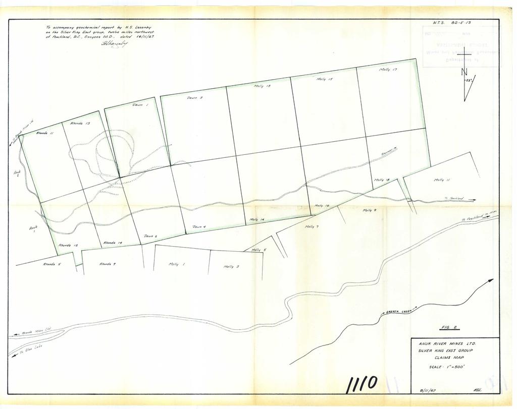
3 Contents Introduction P. 1 Method of Survey P. 1 Interpretation of Results p. L&2 Statement of Work Done P. 3 Statement of Qualifications P. 4 Statement of Professional Experience P. 4 Statement of Qualifications - W.S. Read P. 5 Illustrations Location Map Fig Frontispiece -+ Claim Map Fig In pocket #- -g Geochemical Plan Fig In pocket -#-.L

4
5 Geochemical Survey of Silver King East group of Mineral Claims 1967 Introduction The Silver King East group of mineral claims is located approximately 12 miles northwest of Peachland, B.C., in the Osoyoos Mining Division. Between 4th April and 8th July, 1967, lines were cut and a geochemical survey was run covering parts of claims Ehonda 11, 12, 13, 14, Dawn 1, 2, 3, 4, and Molly 13, 14, 15, 16, 17, 18. The geochemical work was done by a surveyor and his helpers under the supervision of a geologist. Lines trending north-south were cut through the bush and were tied in by chain and transit surveys. Together with the base line, the total line cut on this particular part of the property is in excess of 41,000 ft. The relation of the lines to the claim boundaries is shown on fig. 3 accompanying this report. Method of Survey Samples of the sub-humus soil layer were collected at 200 ft. intervals on all the north-south lines. The samples were put into paper sample bags and their locations marked on the bags. Alternating samples on each line were assayed for copper and molybdenum by Technical Service Laboratories Ltd. and their results plotted. The assays for copper were done by the hot HC1-acid extraction method and those for molybdenum by the Zn - dithiol method. The purpose in assaying every second sample was to keep the assay costs to a minimum. It was felt that any anomalous areas would still be picked up and that they then could be further delineated by assaying the remaining samples from the particular area. Interpretation of Results The area being discussed is underlain by the Nicola Group, an intermixture of altesed greenstones and sediments. Much of the area is covered by glacial debris. Previous tests illustrate that values up to 100 ppm copper and 3 ppm molybdenum are not uncmon and should be interpreted as being background values.
6 .~~ ~ ~ ~ ~ - 3 -? DOMINION OF CANADA: 1 PRoVINCE OF BRrTrsH columsu~ TO WIT: i I 1 In f@ &ffk?r nf Geochemical work on the Silver King East group of mineral claims 4. H. S. Lazenby of Anuk River Mines Ltd., West Hastings Street in the Province of British Columbia, do solemnly declare that the following work was done miles of line cutting at a cost of $70.00 per mile G.E. Garraway - Surveyor and Soil Sampler 4 April-8 July, $30.00 S. Feist - Surveyors helper and soil sampler 4 April-8 July, $ R. Wilkinson - Surveyors helper and soil sampler 4 April-8 July, $20.00 H. S. Lazenby - Geologist 4 April-8 July, $30.00 T.S.L. Ltd , $1, to be applied as follows: $ to each of the following claims: Rhonda 11, 12, 13, 14 Dawn 1, 2, 3, 4 Molly 13, 14, 15, 16, 17, 18 -, And I make this solemn declaration conscientiously believing it to be true, and knowing that it is of /. the same force and effect as if made under oath and by virtue of the "Canada Evidence Act." Declared before me at the 2 1 of 4, in the I I ~&Lu.-,- de* 5 67, A.D. J : Province of British Columbia, this / 6 T-" day of *o
7 - 2 - Results of the assaying failed to reveal any meaningful geochemical pattern (fig. 3). The one area which at first glance appears to be anomalous, in fact contains only background values in copper. The hillside is fairly steep in this area and the soils present are generally residual, containing small, highly fractured fragments of limey volcanics. Minor specks of chalcopyrite along fracture planes were noted on this slope and probably account for the higher assays.
8 - 4 - Statement of Qualifications Graduated B.A. Columbia in May, in geology from the University of British Professional ExDerience Geologist, Rio Canadian Exploration Ltd. engaged in mineral exploration in B.C. and Quebec Geologist, Rio Tinto Finance & Exploration Ltd. engaged in mineral exploration in British Guiana Geologist, Northspan Uranium Mines Ltd. Lacnor mine, engaged in ore reserve calculations, mapping, grade control, diamond drill supervision Geologist, Quebec Metallurgical Industries Ltd., Frobisher Ltd., Ventures Ltd., Falconbridge Nickel Mines Ltd. engaged in property development and mineral exploration in British Columbia Geologist, Anuk River Mines Ltd. engaged in mineral exploration and property development in British Columbia. Vancouver, B.C. 16 November 1967 Geolog&t /
9 - 5 - November 16, 1967 The Mining Recorder Vancouver, B.C. Dear Sir: This is to certify that the work and report of H.S. Lazenby covering the geochemical survey on the Silver King East group was done under my supervision. Mr. Lazenby is fully qualified as a geologist with 12 years field and underground experience since graduation. Mr. G. E. Garraway is a fully qualified surveyor with many years experience in the field and underground. Yours truly,

10
11
ASSESShAENT REPORT Mines and Petroleum Resources. Department of. No* JIMMY MINERAL CLAIM FRANKLIN CREEK AREA, GREENWOOD M. D.
 GEOCHEMICAL REPORT ON JIMMY MINERAL CLAIM FRANKLIN CREEK AREA, GREENWOOD M. D. Lat. 49'35' OON, N.T.S. Long. 118O22' 00W 82-E-9 July 18-21, 1974 Vancouver, B.C. J.J. McDougall, P.Eng. July 21, 1974 * Department
- LONGITUDE : 128'06 'W
 COMINCO LTD. WESTERN DISTRICT MARCH 1977 SOIL GEOCHEMICAL SURVEY SAND 1 and SAND 2 CLAIMS HIDDEN VALLEY AREA LIARD MINING DIVISION LATITUDE : 59'03' - LONGITUDE : 128'06 'W JUNE 20/76-JULY 12/76 REPORT
NTS 93L/9W GEOCHEMICAL AND GEOPHYSICAL REPORT MONA CLAIM OMINICA MINING DIVISION. Lati tude 54036'N; Longitude 'W
 GEOCHEMICAL AND GEOPHYSICAL REPORT ON MONA CLAIM OMINICA MINING DIVISION Lati tude 54036'N; Longitude 126018'W NTS 93L/9W April 1981 Paul Plicka Consulting Geologist LOCATION MAP INTRODUCTION TABLE OF
GEOCHEMICAL REPORT THE 82M/12 FH GROUP BIRCH ISLAND, B.C. S1 119O NOW. ROYAL CANADIAN VENTUR 3S LTD. By: Vollo, P. Eng. N.B. Pay 28th, 1969.
 c GEOCHEMICAL REPORT ON THE 82M/12 FH GROUP AT BIRCH ISLAND, BC S1 119O NOW BY ROYAL CANADIAN VENTUR 3S LTD NB By: Vollo, P Eng Pay 28th, 1969 Approximately 700 samples were collected over 14 miles of
NICOLA M.D King Street West, April, 1969 AMALG 1-44 MINERAL CLAIMS 1. OWNER: Dr. F. R. Burton, W. M. Sirola, P. Eng.
 REPORT ON ' MAGNETIC AND ELECTROMAGNETIC SURVEY AMALG 1-44 MINERAL CLAIMS 1. NICOLA M.D. 49'501 N - 12Oo57f W OWNER: Dr. F. R. Burton, 1506-44 King Street West, Toronto 1, Ontario. by W. M. Sirola, P.
Work performed between August 1 and December 1, 1975 COMINCO LTD. WESTERN DISTRICT NTS 93 '(~15 EXPLORATION GEOCHEMICAL SURVEY THE CRY AND CAB CLAIMS
 COMINCO LTD. EXPLORATION WESTERN DISTRICT NTS 93 '(~15 GEOCHEMICAL SURVEY ON THE CRY AND CAB CLAIMS CRIN PROPERTY Work performed between August 1 and December 1, 1975 NICHOLAS L. SZABO TABLE OF CONTENTS
NO. MAP..._._..._...,,..,.
 KERR- ADDISON GOLD MINES LIMITED SELF-POTENTIAL SURVEY OWL!i- 12 1 Dwner ) NAOINA 1-4 ) MINERAL CLAIMS W. F. McGowan, ) 3262 Marine Orive, ANGUS 1-4 ) west Vancouver, 8. c. LOCATED AT 5. E. ENO OF OWEN
GRISWOLD CREEK, B.C. 6 " GEOCHJ3lICAL REPORT
 GRISWOLD CREEK, B.C. 6 " GEOCHJ3lICAL REPORT AUTROR: W. Meyer, BSc. ENDORSED El!: John De Leen, BASc.* NASc., E.M., P. Eng. No. 3675 Vancouver, B.C. January 22nd, 1965. -I- During the period of July 27th
0.. HUDSON BAY EXPLORATION AND DEVELOPMENT COMPANY LIMITED OMINECA MINING DIVISION BRITISH COLUMBIA REPORT ON EXPLORATION PROGRAM
 'I '0; 63 HUDSON BAY EXPLORATION AND DEVELOPMENT COMPANY LIMITED LSD CLAIM PROPERTY OMINECA MINING DIVISION Q. i!' p BRITISH COLUMBIA REPORT ON EXPLORATION PROGRAM - 972 BY R. A. FREBERG, P. ENG. SEPTEMBER
SUMMl'l WlLS LIU. GEOPHYSICAL REPORT. W. CT. a~evenson Y I
 SUMMl'l WlLS LIU. GEOPHYSICAL REPORT W. CT. a~evenson Y3 qi@, 1970. I 2-90 9 CONTENTS - PAGE Introduction... 1 Property... 1 Location and Access... 1 Survey Specifications Survey Grid... 1 Induced Polarization
7 miles West of Kamloops, B.C.
 MINERAL RESOURCES BRANCH ASSEWAENT RiPORT of hole # 78-11 NO. drilled on the ZZ # 18 Claim of China Commercial Corporation Ltd situated 7 miles West of Kamloops, B.C. in the Kamloops Mining Division D.R.
A PRELIMINARY REPORT ON THE ZYMOST2 CLAIM GROtP, TERRACE, B.C.
 NATIVE EXPLORATIONS LTD. A PRELIMINARY REPORT ON THE ZYMOST2 CLAIM GROtP, TERRACE, B.C. INTRODUCTION': The Zymoetz claim group is, at present, held under option by Native Explorations Ltd.. On the 19th
BALFOUR MINING LTD. (N.P.L.) HAM GROUP 92-P-6, CLINTON M. D.8 B. C. Lat 51 17'N, GEOCHEMICAL REPORT. V. CUKOR, P. Eng.
 HAM GROUP 92-P-6, CLINTON M. D.8 B. C. Lat 51 17'N, GEOCHEMICAL REPORT. V. CUKOR, P. Eng.") 34q '7 BALFOUR MINING LTD. (N.P.L.) HAM GROUP 92-P-6, CLINTON M. D.8 B. C. Lat 51 17'N, Long 12lo14'W GEOCHEMICAL REPORT, V. CUKOR, P. Eng. January 31, 1972 TABLE OF CONTENTS 1. INTRODUCTION 2. PROPERTY,
34q '7 BALFOUR MINING LTD. (N.P.L.) HAM GROUP 92-P-6, CLINTON M. D.8 B. C. Lat 51 17'N, Long 12lo14'W GEOCHEMICAL REPORT, V. CUKOR, P. Eng. January 31, 1972 TABLE OF CONTENTS 1. INTRODUCTION 2. PROPERTY,
3 I1 I I Ill 111 II! II 111 II Ill I IlE I I P I
 -7 3 1 1 11111111111111111111111111111111 ll 111! 111 111 111 111 111111111111111 ll 1111111 1 11111111111111 le P GEOCHEMCAL SURVEY OF THE KE AND D'ARCY CLAM GROUPS.. Similkameen Mining Division, B.C.
M.K.Lorimer, B.A.s~.,P.B~~.
 P! 1.,..,.... * JIM AND HOY GROUPS.8' ",., -. M.K.Lorimer, B.A.s~.,P.B~~. Kellex fining CO. ~ t d.(n.p.l.) August 28-- November 4, 1%6....... t I :'. ~ ww HILL, MANNING & ASSOCIATES LTD. CONSULTINO MINING
7 MILES WEST OF PORT HARDY, B.C.
 GEOPHYSICAL REPORT VERTICAL INTENSITY MAGNETOMEER SURVEY ON LUK CLAIMS, 7 MILES WEST OF PORT HARDY, B.C. 50' 127O SE BY R. E. SHIELDS UNDER SUPERVISION OF J. R. BILLINGSLEY FOR SECOND0 MINING LTD. (N.
CONSULTING GEOLOGICAL & MINING ENGINEERS 1000 GUINNESS TOWER VANCOUVER I, B.C. GEOCHEMICAL AND GEOLOGICAL RE PORT
 DOLMAGE CAMPBELL & ASSOCIATES LTD. CONSULTING GEOLOGICAL & MINING ENGINEERS 1000 GUINNESS TOWER VANCOUVER I, B.C. GEOCHEMICAL AND GEOLOGICAL RE PORT on RAVEN MINERAL CLAIMS Nos. 1-10 and 17-21 Claim Sheet
GEOLOGICAL MAPPING REPORT ON THE ASH MINERAL CLAIM OSOYOOS MINING DIVISION ASHNOLA RIVER MAP SHEET NTS M092,H019 MCBRIDE CREEK AREA, ASHNOLA RIVER,
 GEOLOGICAL MAPPING REPORT ON THE ASH MINERAL CLAIM OSOYOOS MINING DIVISION ASHNOLA RIVER MAP SHEET NTS M092,H019 LATITUDE 49 o O6, LONGITUDE 120 o 22 MCBRIDE CREEK AREA, ASHNOLA RIVER, KEREMEOS, B.C. CANADA
OSOYOOS UINING DIVISION. 49% - 20' North Latitude 120% - 05' West Longitude. GOOD HOPE RESOURCES LTD West Hastings Street Vancouver, B. C.
 REPORT ON HORSEFLY PROPERTY DIAMOND DRILLING - 1982 OSOYOOS UINING DIVISION 49% - 20' North Latitude 120% - 05' West Longitude 9 x It/YG FOR GOOD HOPE RESOURCES LTD. 1518-1177 West Hastings Street Vancouver,
PROSPECTING REPORT THE WALLACE CLAIM OMENICA MINING DIVISION. 54" x6" 3.d d. for. Reako Exlorat ions Ltd. Wallace Rev. C.G.
 PROSPECTING REPORT ON THE WALLACE CLAIM OMENICA MINING DIVISION 54"44 14 1x6" 3.d d by David A. Howard P.Eng. for Reako Exlorat ions Ltd. Claim Locat ion Wallace Rev. C.G. #1560 Dome Mountain Area 9 3
J.D. Mason, Prof. Engineer. Report on the Reconnaissance Magnetometer Survey. Completed for. North American Platinum Corporation Ltd.
 Report on the Reconnaissance Magnetometer Survey Completed for North American Platinum Corporation Ltd. Olivine Mountain Property, Tulameen, B.C. J.D. Mason, Prof. Engineer. November 28, 1967. Certificate
1 NO. I I ...U. 03 MAP...~...w.,... April 23, ASSZS Sr'ii E I4 T RE FORT. Mines and Petruleurn iiecaurces. Department of
 3" Zork dore by f 1 NO. Department of Mines and Petruleurn iiecaurces ASSZS Sr'ii E I4 T RE FORT 03 MAP...~....w.,......U I I April 23, 1973 AGILIS EXPLORATION SERVICES LTD. CONSULTING ENGINEERS & GEOLOGISTS
49" 3-4 I4 I \ Y 59 tj
 ASSESSMENT REPORT Mary 4 FORT STEELE M.D. NTS 82G/5W 49" 3-4 4 \ Y 59 tj Owner: St. Eugene Mining Corporation Limited Operator : St. Eugene Mining Corporation Limited Author: John R. Wilson Date Submitted:
CONSULTING GEOLOGICAL 8: MINING ENGINEERS STINGS STREET DA V6E 2E9 GEOPHYSICAL SURVEY SILVER QUEEN 2 ZEBALLOS AREA. B.C.
 DOLMAGE CAMPBELL & ASSOCIATES (1 975) LTD. CONSULTING GEOLOGICAL 8: MINING ENGINEERS STINGS STREET DA V6E 2E9 '' 1E O L 0 G I C A.L B'x;&a:f2:#& 'SESSMENT REPObT 12, Assessment RESOURCES LTD. 111 ReDort
s4sd HAP 2- V/< CH I N 00 K CONSTRUCTION LOCATION AND CLAIMS MAP Hammer Seismic Lines SCALE - I " = b2 MILE APPROX. May / 75 " d' LHk# (6
 Carpenter -0.e Hammer Seismic Lines N I V/< " d' LHk# (6 /..,Adr4,..8/ "".."/"" f dd..~#cbb /// CH I N 00 K CONSTRUCTION LOCATION AND CLAIMS MAP SCALE - I " = b2 MILE APPROX. s4sd HAP 2- May / 75 INTRODUCTION
PRECIOUS METALS. owner. JMT Services Corp. GEOCHPlICAL SAMPLING CHELASLIE WCE, NORTH CENTRAL, B.C. OMINECA MINING DIVISION NTS 93F/5E & 6W
 PRECIOUS METALS REPORT ON 1980 RECONNAISSANCE GEOCHPlICAL SAMPLING CHELASLIE WCE, NORTH CENTRAL, B.C. OMINECA MINING DIVISION NTS 93F/5E & 6W LATITUDE 53O28 N LONGITUDE 125O31 W DATES Qp WORK: JULY 10
compietea since tnat date, and wnicn comprisea btage I ot tne recommended
 compietea since tnat date, and wnicn comprisea btage I ot tne recommended four-stage program. GEOLOGY & MINERALIZATION The property situate6 on the southeast slope of Nickel Plate Mtn., and within the
..!I AXE CLAIMS ON THE. for RICHCORE EXPLORATIONS LTO. GREENWOOD MINING DIVISION BRITISH COLUMBIA. Latitude 49O 30"; Longitude 118' 30'W NTS 82E/9W
 ON THE AXE CLAIMS for RICHCORE EXPLORATIONS LTO. GREENWOOD MINING DIVISION BRITISH COLUMBIA Latitude 49O 30"; Longitude 118' 30'W NTS 82E/9W... -... ~ i.,...._.'..!i Vancouver, B.C. September, 1980 P.
Pacific Empire Minerals Provides Copper King RC Drilling Results
 Pacific Empire Minerals Provides Copper King RC Drilling Results November 1, 2018 - Vancouver, BC, Canada - Pacific Empire Minerals Corp. (TSXV: PEMC) ( Pacific Empire, PEMC or the Company ), a hybrid
The SL group is located 10 miles east of Lac La Hache and can be reached by good secondary roads.
 0 Summary Soil samples were collected and analyzed for trace mercury vapour content over a magnetic and electromagnetic anomaly. Weak positive evidence of base metal mineralization was obtained. Location
EXPLOR INTERSECTS MULTIPLE COPPER ZONES GRADES UP TO 3.65% CU OVER 5.35 METERS ON THE CHESTER COPPER PROPERTY
 15 Gamble East Street - Suite 204 - Rouyn-Noranda (Canada) J9X 3B6 Listing (TSX-V = EXS) (OTCQB = EXSFF) (FSE & BE = E1H1) EXPLOR INTERSECTS MULTIPLE COPPER ZONES GRADES UP TO 3.65% CU OVER 5.35 METERS
CHIVAS A New Large Scale Au-Ag-Te-Cu Target
 Northwest British Columbia April 4, 2017 CHIVAS A New Large Scale Au-Ag-Te-Cu Target The Kamloops Exploration Group 2017 30 YEARS OF DISCOVERY 1 Gary R. Thompson, P.Geo. SAFE HARBOUR STATEMENT Information
6. E. Spencer Engineering Ltd. '1 iias k*-&-!
 6. E. Spencer Engineering Ltd. '1 iias k*-&-! CONSULTING GEOLOGICAL ENGINEER REPORT ON A GEOCHEMICAL SOIL SURVEY ON THE AXL 3 MINERAL CLAIM KAMLOOPS MINING DIVISION, N.T.S. 82,M/4 LATITUDE: 51O N, LONGITUDE:
GEOPHYSICAL REPORT THE CAVZ CLAIMS
 GEOPHYSICAL REPORT Magnetometer Survey on THE CAVZ CLAIMS CAVZ M.C.'s 1 to 12, 15 to 26, 29 to 40, 45 to 54 Trail Peak, Omineca M.D. 13 miles northeast of Fort Babine 550 ) 126 S.E. by G.Podolsky J.Russell
TOPOGRAPHICAL SURVEY REPORT ON THE GREENDROP PROPERTY NEAR CHILLIWACK, B.C. 92-H-3/W
 TOPOGRAPHICAL SURVEY REPORT ON THE GREENDROP PROPERTY NEW WESTMINSTER M.D. NEAR CHILLIWACK, B.C. 92-H-3/W Location: The central pap of the claims is located at coordinates 49 08'N, latitude by 121 26'W,
rmwr ON EXPLORATION PROGRAM
 NORTHLODOE COPPER MINES LTD. ALICE ARM, B.C. PROPERTY rmwr ON EXPLORATION PROGRAM 1966 OM BEHALF OF G.H.D. CONSULTAWPS LTD. by A. C. A. HOWE & ASSOCIATES LTD. TOROWN), OBITAR10 REPORT NO. 41 A. C. A. HOWE
InZinc Intersects 6.8m of 16.5% Zinc Focuses on Western Expansion of High Grades at West Desert Project
 InZinc Mining Ltd. 912 1112 West Pender Street P.O. Box 48268, Station Bentall Centre Vancouver, BC Canada V7X 1A2 1.604.687.7211 info@inzincmining.com inzincmining.com TSX-V: IZN August 27, 2018 News
Cominco ltd. REPORT OF GRID "C" GEOCHEMICAL SURVEY ON VINE 1 CLAIM, VINE 1, 25, 27 CLAIM GROUP Fort Steele Mining Division
 GOVERNMENT OFFICE Cominco ltd. EXPLORATION DIVISION REPORT OF GRID "C" GEOCHEMICAL SURVEY ON VINE 1 CLAIM, VINE 1, 25, 27 CLAIM GROUP Fort Steele Mining Division Submitted by: E.W. BATCHELOR Cominco Ltd.
.April 3, Jon G. Baird, B.Sc., P.Eng. LOCATION : One mile west of Mile 70 on the Haynes Road At lin Mining Division 135" 59 O SE
 , It I i REPORT ON MAGNETIC AND ELECTROMAGNETIC SURVEYS ON SOME LUNAR CLAIMS NADAHINI MOUNTAIN AREA NORTHERN BRITISH COLUMBIA ON BEHALF OF MAX FUERSTNER AND IRWIN DEFT 1 t Jon G. Baird, B.Sc., P.Eng..April
PHYSICAL WORK REPORT. the BAY CLAIMS. Omineca Mining Division Smithers, British Columbia N.T.S. 93E 13E/W
 PHYSICAL WORK REPORT the BAY CLAIMS Omineca Mining Division Smithers, British Columbia a N.T.S. 93E 13E/W LATITUDE: 53 57 00 N I LONGITUDE: 127 45 OO W for Home Ventures Ltd. 1201-675 West Hastings Street
GRANGES EXPLORATION AB CANADIAN DIVISION
 GRANGES EXPLORATON AB CANADAN DVSON GEOCHEMCAL REPORT ON "B" and "D" CLAMS OMNECA MNNG DEVSON FAWNE NOSE AREA LATTUDE: 53O 19' LONGTUDE: 125O 1' MNERAL RESOURCES BRANCH N.T.S 93F/6 E Owner and Operator
PROSPECTORS ASSISTANCE PROGRAM MINISTRY OF ENERGY AND MINES
 BRITISH COLUMBIA PROSPECTORS ASSISTANCE PROGRAM MINISTRY OF ENERGY AND MINES GEOLOGICAL SURVEY BRANCH PROGRAM YEAR: 1999/2000 REPORT #: PAP 99-l 6 NAME: KIM ANSCHETZ PROSPECTORS TlEPORT on the 99 LOUIS
ASSESSMENT REPORT ON THE PEAVINE PROJECT. DGW & Associates # Alberni Street, Vancouver, British Columbia, V6E 4V2
 ASSESSMENT REPORT ON THE PEAVINE PROJECT KAMLOOPS MINING DIVISION BRITISH COLUMBIA NTS 082M 12 Latitude 51 36' 19.0"North -- Longitude --119 47' 27.0"West UTM Zone 11, NAD 83 5720827N 306744E Prepared
GEOPHYSICAL REPORT of the GROUND MAGNETO METER S U RVEY. on the LOC MINERAL CLAIMS SELISH MOUNTAIN AREA, B. C. NICOLA MINING DIVISION
 f -. GEOPHYSICAL REPORT of the GROUND MAGNETO METER S U RVEY on the LOC MINERAL CLAIMS SELISH MOUNTAIN AREA, B. C. NICOLA MINING DIVISION Latitude: 49'49" Longitude: 120'48'W N.T.S. 92H/15 on behalf of
sq N & %%.& GEOPHYSICAL CONSULTING rr SERVICES LTD. $%& Long. 118o3OtW N.T.S. 82 E/15 -I- AUTROR: Glen E. Whi*e, B.Sc., P. %g.
 -\ GEOCHEMICAL EXPORT.,~.,~..'.. AMORE MINERALS 1NCORPOR;ITZC,' ~. 3rd fl5 Geo 3. and 2 mineral claims, Vernon- ~ $lining Division, B. C. Lat. 49 47'T?,,/ Long. 118o3OtW N.T.S. 82 E/15 -I- AUTROR: Glen
Update on Columbus Gold's Eastside Gold Discovery in Nevada
 Columbus Gold Corporation 1090 Hamilton Street Vancouver, B.C. V6B 2R9 Phone: (604) 634-0970 Fax: (604) 634-0971 Toll Free: 1 888 818-1364 info@columbusgroup.com www.columbusgroup.com NEWS RELEASE Update
'-7' REPORT ON A MAGNETOMETER SURVEY OVER PART OF THE MAX CLAIM GROUP 1-20 LAC LE JEUNE AREA KAMLOOPS MINING DIVISION KAMLOOPS, BRITISH COLUMBIA
 I,., - SUITE 102. 222 BELLEVUE WES t ANCOUVER, B. '-7' REPORT ON A I MAGNETOMETER SURVEY OVER PART OF THE MAX CLAIM GROUP 1-20 LAC LE JEUNE AREA KAMLOOPS MINING DIVISION KAMLOOPS, BRITISH COLUMBIA 50-30
M.R.# _..._ $._. ' VANCOUVER, R.C
 COMINCO LTD. EXPLORATION NTS: 0G/ WESTERN CANADA 0 November ASSESSEMENT REPORT GEOCHEMICAL SURVEY ON THE SADDLEHORN PROPERTY LIARD MINING DIVISION BRITISH COLUMBIA M.R.# _....._ $._. ' VANCOUVER, R.C I
GOLDPLAY ANNOUNCES FURTHER SAMPLING RESULTS FROM SAN MARCIAL HISTORICAL CORE; CONFIRMS OPEN PIT TARGET NEAR SURFACE WITH gpt AgEq.
 GOLDPLAY ANNOUNCES FURTHER SAMPLING RESULTS FROM SAN MARCIAL HISTORICAL CORE; CONFIRMS OPEN PIT TARGET NEAR SURFACE WITH 46.0 METERS @ 129 gpt AgEq. August 28, 2018, Vancouver, BC - Goldplay Exploration
CAUTIONARY NOTE BHS: TSX-V
 CAUTIONARY NOTE The Company advises that the following presentation includes forward looking statements and contains information that is of a historic nature. Historic production estimates, drill information
News Release No GOLD AND COPPER MINERALIZATION DISCOVERED DURING PHASE 2 EXPLORATION AT THE MCBRIDE PROPERTY
 November 19, 2018 TSX Venture Exchange Listed Frankfurt Exchange Listed News Release No. 303-2018 GOLD AND COPPER MINERALIZATION DISCOVERED DURING PHASE 2 EXPLORATION AT THE MCBRIDE PROPERTY Vancouver,
GEOPHYSICAL REPORT CHU CHUA PROJECT Green Mountain Group. KAMLOOPS MINING DIVISION NTS 92P/8E, 82M/5W Lat: 51'24' N Long: 120'00' w
 I GEOPHYSICAL REPORT CHU CHUA PROJECT Green Mountain Group KAMLOOPS MINING DIVISION NTS 92P/8E, 82M/5W Lat: 51'24' N Long: 120'00' w I rvm #.,_..._..._._._.- $...-...! 1 VANCOUVER, B.C. 1 G E 0 I, 0.G
MtNERAL EXPLORATION CONSULTANTS ASSESSMENT REPORT MT. MILLIGAN AREA OMINECA M.D. Latitude: 55' 07' N Longitude: 123" 56' W NTS : 93 0/4 W.
 D. L. COOKE AND ASSOCIATES LTD. MtNERAL EXPLORATION CONSULTANTS ASSESSMENT REPORT 1989 PRELIMINARY GEOCHEMICAL SURVEY KC MINERAL CLAIMS MT. MILLIGAN AREA OMINECA M.D. Latitude: 55' 07' N Longitude: 123"
COMINCO LTD. GRID A VINE CLAIM GROUP. Fort Steele Mining Division 82G/5. Sulilnit t ed by :
 COMNCO LTD. EXPLORATON DVSON WESTERN DSTRCT REPORT ON GEOCHEMCAL SURVEY GRD A VNE CLAM GROUP Fort Steele Mining Division 82G/5 Sulilnit t ed by : E.W. BATCHELOR Cominco Ltd. Kootenay Exploration 2450 Cranbrook
ASSESSMENT REPORT MAGNETOMETER SURVEY GOLDEN ROD, GOLDEN ROD #2. Long.: General Delivery, Vananda, B. C.
 ASSESSMENT REPORT MAGNETOMETER SURVEY GOLDEN ROD, GOLDEN ROD #2 t=/ NTS 92~110w Lat.: Long.: 49O 44' N 124O 34' W Owner: E. Johanson General Delivery, Vananda, B. C. Operator: Rhyolite Resources I nc.
April Exploring for Canadian Gold in the Rainy River District of Ontario
 April 2013 Exploring for Canadian Gold in the Rainy River District of Ontario 1 Forward Looking Statements This presentation may contain forward-looking statements including but not limited to comments
REPORT SOIL GEOCHEMICAL SURVEY. ATTYCELLEY NO. 2 GROUP (Attycelley Mineral Claims No. 7-10)
") REPORT SOIL GEOCHEMICAL SURVEY ATTYCELLEY NO. 2 GROUP (Attycelley Mineral Claims No. 7-10) Situated 7 miles east of north end of Thutade Lake, Omineca Mining Division British Columbia I Department of I
REPORT SOIL GEOCHEMICAL SURVEY ATTYCELLEY NO. 2 GROUP (Attycelley Mineral Claims No. 7-10) Situated 7 miles east of north end of Thutade Lake, Omineca Mining Division British Columbia I Department of I
GEOCMCAL SURVEY LOOP PROPERTY NCRAIIDA EXPLORATION COMPANY, LIMITED OMINECA MINING DIVISION JULY 5, 1971 TO JULY 30, 1971
 GEOCMCAL SURVEY LOOP PROPERTY NCRAIIDA EXPLORATION COMPANY, LIMITED OMINECA MINING DIVISION JULY 5, 1971 TO JULY 30, 1971 TABLE OF CONTENTS INTRODUCTION 2 li Fig. A (Incation Map) GENERAL GEOLOGY GRID
Blox, Inc. Announces New Drilling Target Defined at Mansounia Gold Project.
 Blox, Inc. Announces New Drilling Target Defined at Mansounia Gold Project. Vancouver, British Columbia, July 6, 2018 Blox, Inc. (OTCQB: BLXX), ( Blox or the Company ) is pleased to announce that a new
46s9. on the. July 19, 1973 to July 24, October, Troup 92-P-8. i nc I u s ive
 N.T.S.= 92-P-8 GEOCHEMICAL REPORT on the 'DUM' CLAIM GROUP A.G. Troup October, 1.473 -.- Names - Record Numbers DUM 1-24 inclusive 122804 to 122827 LOCATION: Little Fort area, British Columbia N.T.S. 92-P-8
on the Diamond Drilling done on the LAKESIOE GROUP of Mineral Claims SLOCAN MINING DIVISION 82-F-14-W Long ' Lat '
 Assessment Work Report on the Diamond Drilling done on the LAKESIOE GROUP of Mineral Claims SLOCAN MINING DIVISION 82-F-14-W Long 117 22' Lat. 49 58' ADRIAN KESLER SILVERTON, B.C. operator LEVON RESOURCES
DRILLING REPORT ON THE HIGHLAND VALLEY, KAMLOOPS MINING DIVISION, OWNED BY GAZA MINES LTD., NEW JERICHO DEVELOPMENT AND TECK CORPORATION
 DRILLING REPORT ON THE GAZA 1 AND JERICHO 1 AND 2 MINERAL CLAIMS / (RECORD NUMBERS 159, 492 AND 161) HIGHLAND VALLEY, KAMLOOPS MINING DIVISION, LATITUDE 50' 26' N; LONGITUDE 120' 55' W; NTS 92-I/7W OWNED
SOIL GEOCHEMISTRY. OK-ll AND OK-Ill MINERAL CLAIMS MOUNT THOEN AREA OMINECA MINING DIVISION, B.C. NTS 93 MI6 E & 7 W
 SOIL GEOCHEMISTRY OK-ll AND OK-Ill MINERAL CLAIMS MOUNT THOEN AREA OMINECA MINING DIVISION, B.C. NTS 93 MI6 E & 7 W LATITUDE 55O23'N, LONGITUDE 127 01W Locke B. Goldsmith, P.Eng. Consulting Geologist December
510 W. HASTINGS STREET
 GEOCHEMICAL SOIL SURVEY OF THE DILLARD & MABEL AREAS BRITISH COLUMBIA PREPARED FOR : CYPRUS EXPLORATION CORPORATION LIMITED 510 W. HASTINGS STREET VANCOUVER,B.C. PREPARED BY: BARRINGER RESEARCH LIMITED
51 46'N Latitude, 119'44'1;!
 COMI)!CO LTD. EXPLORATION NTS: 82 1'1/13E GEOCHEKICAL ASSESSMENT REPORT ON THE SI 1 MINERAL CLAIM in the Kamloops Mining Division 51 46'N Latitude, 119'44'1;! Longitude Work Period: June 25, 1979 - July
t+o...&zz!. ASSESSMENT REPORT Department of Miner and Petroleum Resources MAP.,- INDUCED POLAKIZATION SURVEY OVER THE BROOKS PROSPECT
 5873 INDUCED POLAKIZATION SURVEY OVER THE BROOKS PROSPECT BROOKS PENINSULA AREA VANCOUVER ISLAND, B.C. NANAIMO AND ALBERNI MINING DIVISIONS BY Z. B. DOBORZYNSKI JANUARY, 1976 Department of Miner and Petroleum
BRITISH NEWFOUNDLAND EXPLORATION LIMITED PROSPECTING REPORT JR AND MARK CLAIMS LIARD MINING DIVISION, B. C. By: Michael G.
 BRITISH NEWFOUNDLAND EXPLORATION LIMITED PROSPECTING REPORT JR AND MARK CLAIMS LIARD MINING DIVISION, B. C. By: Michael G. Willia 6- "t f I - -- ---- --.--. Department af I Brinex Report No. ~74546,- NTS
SOIL GEOCHEMISTRY ENTERPRISE MINE NTS 82 F/14 W ARCTEX ENGINEERING SERVICES CONSULTANT, OWNER, OPERATOR, AUTHOR JANUARY, 1.981
 SOIL GEOCHEMISTRY ENTERPRISE MINE t SLOCAN MINING DIVISION, Bn C, NTS 82 F/14 W LATITUDE 49'49') LONGITUDE 1'19' ARCTEX ENGINEERING SERVICES I L, B, GOLDSMITH, PiENG, CONSULTANT, OWNER, OPERATOR, AUTHOR
of Youbou, V.I. on Work Done between Aulqust 10 and November four miles north 4a0w0 NE J.H. Mcmtqomery, Ph.D. P. Enq. GEOCHEMICAL SEPORT
 GEOCHEMCAL SEPORT on Work Done between Aulqust 10 and November 19. 1969, on Anne 23-3Ze 35-40 0.--...-, Mineral,..-... ~. -. -...: ::,;./.,....... ;; ' ',Claims.. owned::by Hlbernla Mlnlnq Co. Ltd.,' '..'
GOLD REACH (GRV) ANNOUNCES A 141% INCREASE IN INDICATED AND 91% INCREASE IN INFERRED RESOURCES AT SEEL
 ANNOUNCES A 141% INCREASE IN INDICATED AND 91% INCREASE IN INFERRED RESOURCES AT SEEL") GOLD REACH (GRV) ANNOUNCES A 141% INCREASE IN INDICATED AND 91% INCREASE IN INFERRED RESOURCES AT SEEL New Resource at Seel Contains 2.81 Billion lbs of Cu Eq Inferred Plus 0.58 Billion lbs of Cu Eq Indicated
GOLD REACH (GRV) ANNOUNCES A 141% INCREASE IN INDICATED AND 91% INCREASE IN INFERRED RESOURCES AT SEEL New Resource at Seel Contains 2.81 Billion lbs of Cu Eq Inferred Plus 0.58 Billion lbs of Cu Eq Indicated
VANCOUVER, B.C. Tri 082F/ F/059
 GEOCHEMCAL REPORT t MAY L, 2006 Whbpper Mineral Claims Ailsa Lake Area Gold comm~ss16fl8f"s Offim on Mining Division VANCOUVER, B.C. Tri 082F/058 082F/059 3792 E 5486438 N Operator Kootenay Gold nc. Suite
Haoma Mining NL A.B.N
 Haoma Mining NL A.B.N 12 008 676 177 Registered Office & Head Office: 411 Collins Street, Melbourne, Vic., 3000, GPO Box 2282U, Melbourne, Vic., 3001. Telephone (03) 9629 6888, Facsimile (03) 9629 1250
UNION MINIERE EXPLORATIONS AND MINING CORPORATION LIMITED ASSESSMENT REPORT ON FITINAT MINERAL CLAIM. Alberni Mining Division Record No.
 M F )( UNION MINIERE EXPLORATIONS AND MINING CORPORATION LIMITED Suite 200, 4299 Canada Way, Burnaby, B.C. V5G 1 H4 Telephone (604) 437-9491 ASSESSMENT REPORT ON GEOCHEMICAL SOIL SURVEYS AND ROCKSAMPLING
Horizonte Minerals plc / Index: AIM / Epic: HZM / Sector: Mining 22 April Horizonte Minerals plc, ( the Company or Horizonte )
") Horizonte Minerals plc / Index: AIM / Epic: HZM / Sector: Mining 22 April 2008 Horizonte Minerals plc, ( the Company or Horizonte ) Further Drilling Results from Nickel Discovery at Lontra, Brazil Horizonte
Horizonte Minerals plc / Index: AIM / Epic: HZM / Sector: Mining 22 April 2008 Horizonte Minerals plc, ( the Company or Horizonte ) Further Drilling Results from Nickel Discovery at Lontra, Brazil Horizonte
Canadian National Railways tracks from the foot bridge across the. Thompson River from the Trans Canada Highway. A pick-up truck was used
 Canadian National Railways tracks from the foot bridge across the Thompson River from the Trans Canada Highway. A pick-up truck was used on the highway side and a h-wheel drive Jeep was transported by
MONETA PORCUPINE MINES, LIMITED
 MONETA PORCUPINE MINES, LIMITED VANCOUVER 3. B.C. Telephone: MIJtd 1.9721 The Mining Recorder, GRAND FORKS, B.C. Dear Sir:- The following is a record of salaries, wages, and expenses paid in connection
Vendetta Continues to Intersect High Grade Lead-Zinc from Zone 2 Open Pit Target, Pegmont Lead-Zinc Project
 FOR IMMEDIATE RELEASE November 15 th, 2017 (VTT2017 NR # 13) Vendetta Continues to Intersect High Grade Lead-Zinc from Zone 2 Open Pit Target, Pegmont Lead-Zinc Project Vancouver, BC November 15 th, 2017
2013 GEOLOGICAL ASSESSMENT REPORT SHERIDAN HILL PROPERTY
 2013 GEOLOGICAL ASSESSMENT REPORT ON THE SHERIDAN HILL PROPERTY NEW WESTMINSTER MINING DIVISION BRITISH COLUMBIA NTS 092G07 49 16 31 NORTH LATITUDE, 122 39 48 WEST LONGITUDE PREPARED FOR Sheridan Hill
-KERR-ADDISON GOLD MINES LTD. 6EOPHYSICAL & GEOCHEMICAL INVESTIGATION. Of 24 CLAIMS Of THE FAULT GROUP OF MINERAL CLAIMS
 -KERR-ADDISON GOLD MINES LTD. 6EOPHYSICAL & GEOCHEMICAL INVESTIGATION Of 24 CLAIMS Of THE FAULT GROUP OF MINERAL CLAIMS Located About 3 Miles West Of Merritt, B.C. In Nicola M.D. 50 N - 120 w BY W. M.
 ..m,"f.k*"--v- A tot,al of 18 line miles of magnetometer surveying was completed on the "B" and "J" claim groups during August of 197. Approximately two-thirds of the area covered by the survey is glaciated,
TSX.V: TR. Drilling in the Shadow of World-Class Deposits. TR: TSX.V January 2019
 TSX.V: TR Drilling in the Shadow of World-Class Deposits TR: TSX.V January 2019 1 Looking Forward Statement Investors are cautioned that, except for statements of historical fact certain information contained
W. 1.NELSON Jr. P. ENG.
 GEOCHEMICAL AND GEOPHYSICAL SURVEY SNO GROUP CLAIMS W. 1.NELSON Jr. P. ENG. NORANDA EXPLORATION COMPANY, LIMITED OMINECA MINING DIVISION AUG. 17, 1971 - AUG. 29, 1971 TABLE OF CONTENTS - Page INTRODUCTION
RECONNAISSANCE GEOCHEMICAL SURVEY
 RECONNAISSANCE GEOCHEMICAL SURVEY LEGAL, RITA, LOUISE FR. (CHAPLEAU GROUP) REVERTED CROWN GRANTS CHAPLEAU CREEK AREAJ, SLOC& MINING DIVISION 82 F/11W Lat: 49'44" Long: 117"22'W MINERAL RESOURCES BRANCH
CanAlaska Uranium Details Extensive Rare Earth Mineralization at NE Wollaston
 FOR IMMEDIATE RELEASE NEWS RELEASE CanAlaska Uranium Details Extensive Rare Earth Mineralization at NE Wollaston Vancouver, Canada, October 20 th, 2009 CanAlaska Uranium Ltd. (CVV TSX.V) (the Company )
Highlights from the four holes announced in this news release include:
 November 20, 2017 OTCQB: SVBL, TSX: SVB SILVER BULL INTERSECTS 9 METERS OF SULPHIDE MINERALIZATION GRADING 20.7% ZINC, 1% LEAD AND 98G/T SILVER, INCLUDING 3.65 METERS OF MASSIVE SULPHIDE MINERALIZATION
ASX RELEASE REVIEW OF GLANDORE DATA TO DEFINE DRILL PROGRAM
 ASX RELEASE 4 April 2007 REVIEW OF GLANDORE DATA TO DEFINE DRILL PROGRAM The Directors of Hemisphere Resources Limited ( Hemisphere or the Company ) are pleased to announce that a review has been conducted
REPORT. on the. Omineca Mining Division, British Columbia. Latitude N., Longitude W. NTS map sheet 93F/7E. James W. McLeod, P.Geo.
 REPORT on the CHU MOLYBDENUM PROPERTY Omineca Mining Division, British Columbia Latitude 53 21 N., Longitude 124 37 W. NTS map sheet 93F/7E James W. McLeod, P.Geo. on behalf of Mr. Chris Delorme TABLE
lat ' N Long ' W
 305 7 ec1;, REPORT ON THE JERY CLAIMS OF POLA RESOURCES LTD. NTS 93L/16 0 0 lat. 54 45' N Long. 126 22' W BABIXE LAKE AREA OMINECA MINING DIVISION, B.C. PAUL PLICKA CONSULTING GEOLOGIST DECEMBER 30, 1981
July Exploring for Canadian Gold in the Rainy River District of Ontario
 July 2013 Exploring for Canadian Gold in the Rainy River District of Ontario 1 Forward Looking Statements Some of the statements in this document may be deemed to be "forward-looking statements". All statements
82 Richmond Street East Toronto, ON M5C 1P1 T: E: W: eskaymining.com
 NEWS RELEASE FOR IMMEDIATE RELEASE: DECEMBER 7, 2018 Eskay Mining Corp. Reports on 2018 Exploration on the SIB Property, Northwest B.C. Drilling Intercepts Broad Zones of Gold Mineralization - Potential
1 CLAIMS GEOPHYSICAL REPORT ON BOYAL SITUATE NORTHEAST OF TILLICUM MOUNTAIN GOLD AREA BURTON - NAKUSP SIQCAEJ MINING DIVISION
 GEOPHYSICAL REPORT ON BOYAL 1 CLAIMS SITUATE NORTHEAST OF TILLICUM MOUNTAIN GOLD AREA BURTON - NAKUSP SIQCAEJ MINING DIVISION CONSULTING GEOLOGIST AUGUST 1983 VANCOUVER B *C INDEX INTRODUCTION ooa,.eoaaa.aaaoaaooaoa~ao~o
Precipitate s Geophysical Surveying Generates More Targets at Melchor and Peak Zones
 TSX VENTURE: PRG www.precipitategold.com 625 Howe Street, Suite 1020, Vancouver, BC, V6C 2T6 info@precipitategold.com Toll free: 855 558 0335 Direct: 604 558 0335 Precipitate s Geophysical Surveying Generates
GEOLOGICAL BRANCH ASSESSMENT REPORT 12. FItE NO: ACTION: THE GOLDEN MINING DIVISION, GOLDEN, Including THE NTS MAP; M82K/15W
 ACTION: FItE NO: Including 1990 GEO-CHEM SURVEY RESULTS -- THE AVD CLAIMS - THE GOLDEN MINING DIVISION, GOLDEN, B.C. NTS MAP; M82K/15W Lat. 50 deg. 55 Min. Long 116 deg. 55 min. For GEOLOGICAL BRANCH ASSESSMENT
GOLDPLAY OUTLINES FIVE NEW EXPLORATION TARGETS AT THE SAN MARCIAL PROJECT IN MEXICO
 January 18, 2019 GOLDPLAY OUTLINES FIVE NEW EXPLORATION TARGETS AT THE SAN MARCIAL PROJECT IN MEXICO Vancouver, BC - Goldplay Exploration Ltd. (TSXV: GPLY, FRANKFURT: GPE, OTCQB: GLYXF) ( Goldplay or the
A New Direction. Copper-Gold Deposit at Thor TSX.V:COL. August 11, May 2013
 A New Direction Copper-Gold Deposit at Thor August 11, 2016 May 2013 TSX.V:COL FORWARD LOOKING STATEMENTS This presentation includes certain forward-looking information or forward-looking statements for
Surface Trenching Highlights. Santos Target. To (m) Width (m) Au (g/t) Comment. (m) Santos (1)-includes internal dilution
 Width (m) Au (g/t) Comment. (m) Santos (1)-includes internal dilution") Goldplay Exploration announces surface trenching program results to date at the 100% owned El Habal Property: including 130 meters grading 1.86 g/t Au, 100 meters grading 1.20 g/t Au, 90 meters grading
Goldplay Exploration announces surface trenching program results to date at the 100% owned El Habal Property: including 130 meters grading 1.86 g/t Au, 100 meters grading 1.20 g/t Au, 90 meters grading
Serengeti Resources Inc GEOCHEMICAL REPORT ON THE SHADOW PROPERTY a.
 Serengeti Resources Inc. 2004 GEOCHEMICAL REPORT ON THE SHADOW PROPERTY a. Located in the Johanson Lake Area Omenica Mining Division NTS 94D/9 6 degrees and 32 minutes North Latitude 126 degrees and 2
The new sulphide mineralization lies within a 1.4 kilometer long east-west trending
 June 17, 2015 NYSE-MKT: SVBL, TSX: SVB SILVER BULL IDENTIFIES NEW MASSIVE SULPHIDE MINERALIZATION GRADING 690G/T SILVER, 1% COPPER, 4.8% LEAD AND 15.25% ZINC AT THE SIERRA MOJADA PROJECT, COAHUILA, MEXICO.
SALAZAR REPORTS OUTCROPPING GOLD MINERALIZATION AT RUMIÑAHUI, ECUADOR
 #1305-1090 West Georgia Street Vancouver, BC Canada V6E 3V7 Tel: (604) 685-9316 Fax: (604) 683-1585 TSX Venture Exchange: SRL Frankfurt Stock Exchange: CCG NEWS RELEASE MAY 25, 2007 SALAZAR REPORTS OUTCROPPING
GEOPHYSICAL REPORT. Airborne Magnetometer Survey. of the SHEEP-GOAT GROUP OF MINERAL CLAIMS. near Li l looet, B.C.
 GEOPHYSICAL REPORT 977 Airborne Magnetometer Survey of the SHEEP-GOAT GROUP OF MINERAL CLAIMS near Li l looet, B.C. Lillooet Mining Division (Lat.51 'lot Long. 122 40' 7 5t0[2L05E. for DUFFEY LAKES MINES