OSOYOOS UINING DIVISION. 49% - 20' North Latitude 120% - 05' West Longitude. GOOD HOPE RESOURCES LTD West Hastings Street Vancouver, B. C.
|
|
|
- Molly Hodge
- 5 years ago
- Views:
Transcription
1 REPORT ON HORSEFLY PROPERTY DIAMOND DRILLING OSOYOOS UINING DIVISION 49% - 20' North Latitude 120% - 05' West Longitude 9 x It/YG FOR GOOD HOPE RESOURCES LTD West Hastings Street Vancouver, B. C. A.D. WILMOT P. ENG. Kelowna, B.C. November 17, 1982 GEOLOGICAL BRANCH ASSESSMENT REPORT
2 TABLE OF CONTENTS PAGE Introduction... 1 (1) Location and Access... 1 (2) Property... 1 History... 1 Ownership... 1 Economic Assessment... 1 (3) Summary of Work Done... 1 Purpose of Drilling and Results... 1 (4) Notes on Drilling... 2 (5) Statement of Expenditures... 3 (6) Certificate of A.D. Wilmot P. Eng... 4 APPENDICES Key Map... Plate 1 Claim Map... Plate 2 Plan of Surface Drill Holes (in map pocket)... Plate 3 Drill Hole X. Sections L Assays D.D.H. HF Plate 4 D.D.Hs. HF - 2 L HF Plate 5 Drill Hole Logs (in map pocket)
3 -1- INTRODUCTION This report is a record of the diamond drill programme on the Horsefly M.C., during the summer of (1) LOCATION 6 ACCESS The property is located on Nickel Plate Mountain, 18 km. by road from Hedley, B.C. An index map, Plate 1, is appended. The Horsefly is one of 14 contiguous claims, known as the Cabin Group that adjoin to the South of property held by Mascot Gold Mines. HISTORY In 1937 the Trethewey syndicate did 1610 m. of diamond rilling on the property. During 1947 & 1948 Hedley Mascot Gold Mines drove 167 m. of underground workings from an adit and in 1967 Mascot Explorations did further work consisting mainly of surface and underground sampling. OWNERSHIP The property is owned by Good Hope Resources Ltd. of West Hastings Street, Vancouver, B.C. ECONOMIC ASSESSMENT The ore bodies explored by the recent (A drilling are irregular shaped, pods of massive, y a ' * sulphides consisting mainly of pyrohofite arsenopyrite with lessor amounts of chaleopyrite sphalerite with associated gold and silver. Further work will be required to determine the economic importance of the deposit. (111) SUMMARY OF WORK DONE Between September 15th and September 25th 1982, a total of meters of "BQ" wireline drilling was completed in 3 drill holes. The purpose of this drilling was to intersect at shallow depths, certain outcrops of massive sulphides that carry
4 -2- appreciable amounts of gold and silver. The results of this drilling did little more than confirm the irregular shape and tenor of the mineralization. (IV) NOTES ON DRILLING (a) The rock types encountered were a limey metasediment and sills of interbedded diorite. (b) Where massive sulphides were intersected, a sample was cut over the width of mineralization and a 1.5 m. sample taken from both the foot and hanging walls. In country rock the sample interval was 3 m. (c) The assaying was done by DANKOE MINES LTD. A.D. WILMOT P. ENG.
5 -3- (V) STATEMENT OF WPJZNDITURES (1) m. of "BQ" wireline per m...lo, (2) 65 gold 6.50 ea (3) Vehicle rental September 15 to September 30, per week per krn (4) Supervision A.D. Wilmot P. Eng per day... 2, TOTAL 14,508.75
6 -4- CERTIFICATE I, ASEILEY D. WILMOT of KELOWNA, B.C. CERTIFY TEIAT: I GRADUATED FROM QUEEN'S UNIVERSITY IN 1936 WITH A BACHELOR OF SCIENCE DEGREE IN MINING ENGINEERING. I AM A LIFE MEMBER OF THE B.C. PROFESSIONAL ENGINEERS, THE CANADIAN INSTITUTE OF MINING AND METALLURGY AND THE B.C. AND YUKON CHAMBER OF MINES. I HAVE PRACTICED MY PROFESSION FOR OVER FORTY YEARS. /2 A; ' LYl., A.D. WILMOT P. ENG.
7 1 I LOCATION * MAP

8
9 - Scole r I m.
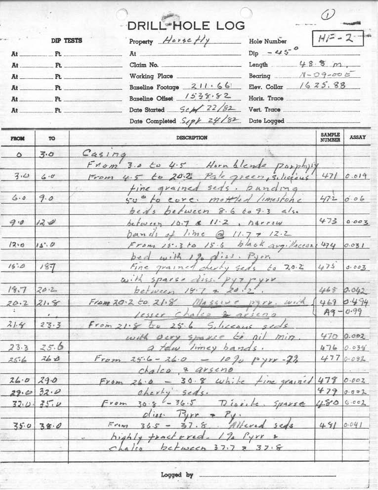
10 ,- - GOOD HOPE RESOURCES LTD. HORSEFLY M.C. X-SECTION 0.ll.H~. HF-2 HF-3 U e I i 0 5 I0 15m. i I PLATE- 5

11 .- Dip. - s-5~. At... Ft. At At Ft. Claim No. At R Working Place Becning. &~ At At ~:...-. R..._...-_I Baseline Footage... Ft. Baseline offset./.-4. Horie Trace?I- At. R._ Date Stcnted..&jE&.d~_- Vert. Trace... Length M A*~.../3..e 20z* 5% - Elev. Collar... L$.%k=,...$!-$-

12 m~. ~ DRILL HOLE LOG ~~~ ~ ~~~~~ ~~~~ ~~ ~~ ~~~ ~ i length DIP TFSTS Properly.- L.-. Hole Number ~ At... Ft.. At At Ft. Claim No..~ I Dip... L ~ At _. R.Working Place. B-g... :.. At - Ft. Baseline Footaye Elev. Collar R Baseline offset --_ Horie. Trace At... At Ft. Me Started Vert. Trace Date Completed._ Date Logged ~ ~~~~~ ~. Loggodby _.. I_--

13 ~ ~ ylr DRILL HOLE LOG TKc2 3- DP lepis hperly. Hole Number pz7-1 At... Ft.. At Dip. At Ft Claim No. Length... At - Ft working Place Eaaring... At Ft Baseline Footage Elev. Collar At Ft. Baseline Offset Horix. Trace At Ft _ Date Started. Vert. Trace Date Completed Date Logged. -- ~~~ ~. ~~.. ~~ Logged by - ~ '.~.!
14

15 I I I I

16

17
on the Diamond Drilling done on the LAKESIOE GROUP of Mineral Claims SLOCAN MINING DIVISION 82-F-14-W Long ' Lat '
 Assessment Work Report on the Diamond Drilling done on the LAKESIOE GROUP of Mineral Claims SLOCAN MINING DIVISION 82-F-14-W Long 117 22' Lat. 49 58' ADRIAN KESLER SILVERTON, B.C. operator LEVON RESOURCES
cpw 6. E. Spencer Engineering Ltd. HANNA 9 M. C. 104 REP 0 RT DIAMOND DRILLING PROGRAMME LIARD MINING DISTRICT, K.T.S. FOR TAURUS RESOURCES LTD.
 6. E. Spencer Engineering Ltd. LlJ REP 0 RT ON DAMOND DRLLNG PROGRAMME cpw HANNA 9 M. C. LARD MNNG DSTRCT, K.T.S. 104 P@g FOR TAURUS RESOURCES LTD. BY B. E. SPENCER, P. ENG. B. E. SPENCER ENGNEERNG LTD.
2013 GEOLOGICAL ASSESSMENT REPORT SHERIDAN HILL PROPERTY
 2013 GEOLOGICAL ASSESSMENT REPORT ON THE SHERIDAN HILL PROPERTY NEW WESTMINSTER MINING DIVISION BRITISH COLUMBIA NTS 092G07 49 16 31 NORTH LATITUDE, 122 39 48 WEST LONGITUDE PREPARED FOR Sheridan Hill
32?un North of Hope, B.C.,
 Geological Reconnaissance Assessment Report on portions of the Gilt Creek Group (Mike, C.G., Julie, and Gilt Mineral Claims) Situated 32?un North of Hope, B.C., New Westminster Mining Division N 'P 97H/11W
GEOLOGICAL MAPPING REPORT ON THE ASH MINERAL CLAIM OSOYOOS MINING DIVISION ASHNOLA RIVER MAP SHEET NTS M092,H019 MCBRIDE CREEK AREA, ASHNOLA RIVER,
 GEOLOGICAL MAPPING REPORT ON THE ASH MINERAL CLAIM OSOYOOS MINING DIVISION ASHNOLA RIVER MAP SHEET NTS M092,H019 LATITUDE 49 o O6, LONGITUDE 120 o 22 MCBRIDE CREEK AREA, ASHNOLA RIVER, KEREMEOS, B.C. CANADA
VAN SILVER EXPLORATIONS LTD. DRILLING REPORT. April 25, h:,*.i '... ~ ;do.
 1..- \.,I ~ ;do. 4339 VAN SILVER EXPLORATIONS LTD. DRILLING REPORT April 25, 1974. I 4939......... h:,*.i '....... -1- VAll SlVfR EXPlORfITlO~S LTD. (N. P. L.) TLLCPHONL (604) 687-4150 118-615 WEST HASTINGS
compietea since tnat date, and wnicn comprisea btage I ot tne recommended
 compietea since tnat date, and wnicn comprisea btage I ot tne recommended four-stage program. GEOLOGY & MINERALIZATION The property situate6 on the southeast slope of Nickel Plate Mtn., and within the
PROSPECTING REPORT THE WALLACE CLAIM OMENICA MINING DIVISION. 54" x6" 3.d d. for. Reako Exlorat ions Ltd. Wallace Rev. C.G.
 PROSPECTING REPORT ON THE WALLACE CLAIM OMENICA MINING DIVISION 54"44 14 1x6" 3.d d by David A. Howard P.Eng. for Reako Exlorat ions Ltd. Claim Locat ion Wallace Rev. C.G. #1560 Dome Mountain Area 9 3
Geo chemi c a1 Rep or t SILVER KING FAST GROUP. H. S. Lazenby Geologist. Vancouver, B.C. 16 November 1967
 Geo chemi c a1 Rep or t on SILVER KING FAST GROUP 1967 Vancouver, B.C. 16 November 1967 H. S. Lazenby Geologist Contents Introduction P. 1 Method of Survey P. 1 Interpretation of Results p. L&2 Statement
for the Greenwood Mining Division, B.C. NTS 82E/7W Latitude 49' 27' W, Longitude 118' 5 Prepared by a= D. Dylan Watt, B.Sc.
 t. b LOGnO: 37~ -08 m. ACTIO#: for the AMP AMP 2 AMP 3 t AMP 4 CLAIMS Greenwood Mining Division, B.C. NTS 82E/7W Latitude 49' 27' W, Longitude 8' 5 %E c,w zc *& a w Prepared by a= -4c. D. Dylan Watt, B.Sc.
1 CLAIMS GEOPHYSICAL REPORT ON BOYAL SITUATE NORTHEAST OF TILLICUM MOUNTAIN GOLD AREA BURTON - NAKUSP SIQCAEJ MINING DIVISION
 GEOPHYSICAL REPORT ON BOYAL 1 CLAIMS SITUATE NORTHEAST OF TILLICUM MOUNTAIN GOLD AREA BURTON - NAKUSP SIQCAEJ MINING DIVISION CONSULTING GEOLOGIST AUGUST 1983 VANCOUVER B *C INDEX INTRODUCTION ooa,.eoaaa.aaaoaaooaoa~ao~o
7 miles West of Kamloops, B.C.
 MINERAL RESOURCES BRANCH ASSEWAENT RiPORT of hole # 78-11 NO. drilled on the ZZ # 18 Claim of China Commercial Corporation Ltd situated 7 miles West of Kamloops, B.C. in the Kamloops Mining Division D.R.
490 20' 30" North Latitude ' 30" West Longitude
 _._.. I CONSULTING GEOLOGISTS 605-602 WEST HASTINGS STREET, VANCOUVER, B.C. V6B 1P2 TELEPHONE: (604) 689-5533 6 I F: ASSESSMENT REPORT ON THE PATSY 1 MINERAL CLAIM ' '?%2% I WHISTLE CREEK, HEDLEY ARE L-l-
TOPOGRAPHICAL SURVEY REPORT ON THE GREENDROP PROPERTY NEAR CHILLIWACK, B.C. 92-H-3/W
 TOPOGRAPHICAL SURVEY REPORT ON THE GREENDROP PROPERTY NEW WESTMINSTER M.D. NEAR CHILLIWACK, B.C. 92-H-3/W Location: The central pap of the claims is located at coordinates 49 08'N, latitude by 121 26'W,
HOWE COPPER MINE PROJECT HIGH GRADE Cu-Ag with Au
 HOWE COPPER MINE PROJECT HIGH GRADE Cu-Ag with Au The Howe Copper Mine property is located approximately 55 kilometres northwest of Vancouver, BC. It is situated at 1431 metres elevation on the eastern
BALMORAL INTERSECTS g/t GOLD OVER 7.99 METRES, BUG LAKE SOUTH, DETOUR GOLD TREND PROJECT, QUEBEC
 TSX: BAR / OTCQX: BALMF October 8, 2014 For Immediate Release NR14-24 BALMORAL INTERSECTS 12.50 g/t GOLD OVER 7.99 METRES, BUG LAKE SOUTH, DETOUR GOLD TREND PROJECT, QUEBEC Continues to Expand High Grade
UNION MINIERE EXPLORATIONS AND MINING CORPORATION LIMITED ASSESSMENT REPORT ON FITINAT MINERAL CLAIM. Alberni Mining Division Record No.
 M F )( UNION MINIERE EXPLORATIONS AND MINING CORPORATION LIMITED Suite 200, 4299 Canada Way, Burnaby, B.C. V5G 1 H4 Telephone (604) 437-9491 ASSESSMENT REPORT ON GEOCHEMICAL SOIL SURVEYS AND ROCKSAMPLING
DRILLING REPORT ON THE HIGHLAND VALLEY, KAMLOOPS MINING DIVISION, OWNED BY GAZA MINES LTD., NEW JERICHO DEVELOPMENT AND TECK CORPORATION
 DRILLING REPORT ON THE GAZA 1 AND JERICHO 1 AND 2 MINERAL CLAIMS / (RECORD NUMBERS 159, 492 AND 161) HIGHLAND VALLEY, KAMLOOPS MINING DIVISION, LATITUDE 50' 26' N; LONGITUDE 120' 55' W; NTS 92-I/7W OWNED
REPORT ON DIAMOND DRILLING AT THE PROPERTY OF CONSOLIDATED CINOLA MINES LTD. ENERGY RESERVES CANADA (METALS) LTD. NOVEMBER - DECEMBER 1984.
 LTD. NOVEMBER - DECEMBER 1984.") REPORT ON DIAMOND DRILLING AT THE PROPERTY OF CONSOLIDATED CINOLA MINES LTD. ENERGY RESERVES CANADA (METALS) LTD. NOVEMBER - DECEMBER 1984 03/8 ig; CINOLA CLAIM GROUP GRAHAM ISLAND, B.C. SKEENA MINING
REPORT ON DIAMOND DRILLING AT THE PROPERTY OF CONSOLIDATED CINOLA MINES LTD. ENERGY RESERVES CANADA (METALS) LTD. NOVEMBER - DECEMBER 1984 03/8 ig; CINOLA CLAIM GROUP GRAHAM ISLAND, B.C. SKEENA MINING
CERRO PRIETO PROJECT MINERAL CONCESSIONS LOCATION AND ACCESS
 Cerro Prieto CERRO PRIETO PROJECT MINERAL CONCESSIONS The Cerro Prieto Project is comprised of three mining exploitation concessions encompassing 2,723 hectares in northern Sonora, Mexico. Oroco holds
REPORT ON A GEOLOGICAL MAPPING AND PROSPECTING PROGRAM LOOK PROPERTY
 b KOKANEE EXPLORATIONS LTDI I WNO. 0 I- n c/ REPORT ON A GEOLOGICAL MAPPING AND PROSPECTING PROGRAM LOOK PROPERTY LOOK 1-31, 36-43 CLAIMS FORT STEELE MINING DIVISION CRANBROOK AREA N.T.S. 82G/5W + 4E E:
A PRELIMINARY REPORT ON THE ZYMOST2 CLAIM GROtP, TERRACE, B.C.
 NATIVE EXPLORATIONS LTD. A PRELIMINARY REPORT ON THE ZYMOST2 CLAIM GROtP, TERRACE, B.C. INTRODUCTION': The Zymoetz claim group is, at present, held under option by Native Explorations Ltd.. On the 19th
7 MILES WEST OF PORT HARDY, B.C.
 GEOPHYSICAL REPORT VERTICAL INTENSITY MAGNETOMEER SURVEY ON LUK CLAIMS, 7 MILES WEST OF PORT HARDY, B.C. 50' 127O SE BY R. E. SHIELDS UNDER SUPERVISION OF J. R. BILLINGSLEY FOR SECOND0 MINING LTD. (N.
RECONNAISSANCE GEOCHEMICAL SURVEY
 RECONNAISSANCE GEOCHEMICAL SURVEY LEGAL, RITA, LOUISE FR. (CHAPLEAU GROUP) REVERTED CROWN GRANTS CHAPLEAU CREEK AREAJ, SLOC& MINING DIVISION 82 F/11W Lat: 49'44" Long: 117"22'W MINERAL RESOURCES BRANCH
for the Greenwood Mining Division, B.C. NTS 82E/7W 29' W, Longitude 118' 53' N Prepared by D. Dylan Watt, B.Sc.
 for the FltE NO: u VOLT 1, VOLT 2, VOLT 3, & VOLT 4 CLAIMS Greenwood Mining Division, B.C. NTS 82E/7W Latitude 49' 29' W, Longitude 118' 53' N Prepared by D. Dylan Watt, B.Sc. #309-1996 Trutch Street Vancouver,
PHYSICAL WORK REPORT. the BAY CLAIMS. Omineca Mining Division Smithers, British Columbia N.T.S. 93E 13E/W
 PHYSICAL WORK REPORT the BAY CLAIMS Omineca Mining Division Smithers, British Columbia a N.T.S. 93E 13E/W LATITUDE: 53 57 00 N I LONGITUDE: 127 45 OO W for Home Ventures Ltd. 1201-675 West Hastings Street
DIAMOND DRILL REPORT ON THE LOCATED IN THE OMINECA MINING DIVISION FAWNIE NOSE AREA LATITUDE: 53O 17' LONGITUDE: 125O 10' NTS 93F 6E
 GRANGES EXPLORATION AB CANADIAN DIVISION DIAMOND DRILL REPORT ON THE G, H and I CLAIM BLOCKS LOCATED IN THE OMINECA MINING DIVISION FAWNIE NOSE AREA LATITUDE: 53O 17' LONGITUDE: 125O 10' NTS 93F 6E. -.
PROSPECTING REPORT. Silver Dollar Property. EVENT # TENURE # Tenure Name: GPEX Silver Dollar
 2008-2009 PROSPECTING REPORT Silver Dollar Property EVENT # 4267989 TENURE # 555462 Tenure Name: GPEX Silver Dollar Similkameen Mining Division Map 092H Central Coordinate Reference 120 06 26.9 W Longitude
HARMONY GOLD PROPERTY SHI 1-3 CLAIMS SKEENA MINING DIVISION BRITISH COLUMBIA CANADA. N.T.S. 103F/8W Latitude 53'1 9'N Longitude 132'25'W
 i - i RECEVED.-.- JUL23lga& Qold Commissioner's office VANCOUY ER, B.C. HARMONY GOLD PROPERTY 996 PROSPECTNG ASSESSMENT REPORT CLAM NAME SH-3 SH - 3 CLAMS SKEENA MNNG DVSON BRTSH COLUMBA CANADA N.T.S.
CONSULTING GEOLOGICAL 8: MINING ENGINEERS STINGS STREET DA V6E 2E9 GEOPHYSICAL SURVEY SILVER QUEEN 2 ZEBALLOS AREA. B.C.
 DOLMAGE CAMPBELL & ASSOCIATES (1 975) LTD. CONSULTING GEOLOGICAL 8: MINING ENGINEERS STINGS STREET DA V6E 2E9 '' 1E O L 0 G I C A.L B'x;&a:f2:#& 'SESSMENT REPObT 12, Assessment RESOURCES LTD. 111 ReDort
Assessment Work Report. on the Geophysical Surveys carried out over the
 Assessment Work Report on the Geophysical Surveys carried out over the PINE GROUP of Mineral Claims 951-J-15-W Lillooet Mining Division Goldbridge, B.C. Long 122 48' Lat. 50 48' by Levon Resources Ltd.
12Io - 25' West Longitude GEOLOGICAL ASSESSMENT REPORT ON THE AU 1 CLAIMS WEST NORSE RESOURCES LIMITED HOPE - YALE AREA
 GEOLOGCAL ASSESSMENT REPORT ON THE AU 1 CLAMS WEST NORSE RESOURCES LMTED HOPE - YALE AREA NEW WESTMNSTER MNNG DVSON R.E. Renshaw, P. Eng. Consulting Geologist 49O - 33' North Latitude 12o - 25' West Longitude
ASSESShAENT REPORT Mines and Petroleum Resources. Department of. No* JIMMY MINERAL CLAIM FRANKLIN CREEK AREA, GREENWOOD M. D.
 GEOCHEMICAL REPORT ON JIMMY MINERAL CLAIM FRANKLIN CREEK AREA, GREENWOOD M. D. Lat. 49'35' OON, N.T.S. Long. 118O22' 00W 82-E-9 July 18-21, 1974 Vancouver, B.C. J.J. McDougall, P.Eng. July 21, 1974 * Department
RISE ANNOUNCES #1 VEIN TARGET AT I-M MINE
 RISE ANNOUNCES #1 VEIN TARGET AT I-M MINE Two exploration drifts from 1942 show exploration target of #1 Vein to depth. Channel samples assay up to 14.0oz/ton (481gpt) over 3.8ft (1.2m). 89 channel samples
DIANOND DRILLING REPORT. NICOLA MINING DIVISION, B.C. Lat 'N, Long. 12O03O'W N.T.S. Map 921/1 W82E. for
 W DIANOND DRILLING REPORT MM #1, MM #2, MM #3, INEZ #1, INEZ #2, AND CROWN GRANTED CLAIMS NICOLA MINING DIVISION, B.C. Lat. 50 10'N, Long. 12O03O'W N.T.S. Map 921/1 W82E for FLAIR RESOURCES LTD. 1417-409
Geochemical Assessment Report. on the. Situated Nineteen Kilometres rth-northeast of Hope, B. C. in the. New Westminster Mining Division
 7 I Geochemical Assessment Report r on the r- I 1 Norm 1 to Norm 4 Mineral Claims c - I - 7 Situated Nineteen Kilometres rth-northeast of Hope, B. C. in the New Westminster Mining Division itude 49*32'N.,
INTRODUCTION ASHLU GROUP. The Ashlu Group is located in the Vancouver Mining Division on
 ; - ( NTRODUCTON ASHLU GROUP The Ashlu Group is located in the Vancouver Mining Division on 8 r ---- n --.. 2 3 120. ', -.. -.- P A C / F / C -- OCEAN -..-.. -.. -. FG. No. 1 REGONAL LOCATON MAP ASHLU
REPORT. on the. Omineca Mining Division, British Columbia. Latitude N., Longitude W. NTS map sheet 93F/7E. James W. McLeod, P.Geo.
 REPORT on the CHU MOLYBDENUM PROPERTY Omineca Mining Division, British Columbia Latitude 53 21 N., Longitude 124 37 W. NTS map sheet 93F/7E James W. McLeod, P.Geo. on behalf of Mr. Chris Delorme TABLE
HIXON CREEK PROJECT. 53 degrees 26 min North Latitude 122 degrees 33 min West Longitude Mineral Claim Map 93G7EJ8W
 HIXON CREEK PROJECT Exploration and Preliminary Diamond Drilling on the Hixon Creek Project situated on Hixon Creek in the Cariboo Mining Division British Columbia 53 degrees 26 min North Latitude 122
VAN SILVER EXPLORATIONS LTD. DRILLING KEP:'OR% April 25, 1974.
 VAN SILVER EXPLORATIONS LTD. (N.P.L.) I DRILLING KEP:'OR% April 25, 1974. Vfln SllVER f XPLORflTlOnS LTD. TELEPHONL (604) 6874150 lie el5 WEST HASTINGS STREET VANCOUVER 1. B.C. ITEPiIZED VALUATION OF WORK
REPORT ON THE MAGNETOMETER SURVEYOF THE SO0 MINERAL CLAIMS MERRITT, B. C.
 336 REPORT ON THE MAGNETOMETER SURVEYOF THE SO0 MINERAL CLAIMS MERRITT, B. C. To: The Directore Copper Soo Mining Syndicate OSO~OOS, B. C. R. C. Clough hglneering Ltd. Harvey H. Cohen, P. Pmg. TABLE OF
A B C PAD A HIGHLIGHTS
 Murchison Minerals Intercepts 12.30% Zinc, 0.70% Copper, 0.18% Lead and 42.03 g/t Silver 14.97% ZnEq over 6.37 Metres and Extends Known Limits of Brabant McKenzie VMS Deposit June 25, 2018 (Toronto, Ontario):
MARKET UPDATE ON URANIUM AND GOLD PROJECTS
 ASX Announcement 1 March 2011 MARKET UPDATE ON URANIUM AND GOLD PROJECTS HIGHLIGHTS 5,000 metre drilling programme to commence at Rio Puerco uranium project within the next two weeks. Drilling to commence
MINERAL MOUNTAIN CONFIRMS PROOF OF CONCEPT IN THE HOMESTAKE GOLD BELT
 MMV-TSX.V MNRLF-OTCQX News Release NR 2018 06 May 3, 2018 MINERAL MOUNTAIN CONFIRMS PROOF OF CONCEPT IN THE HOMESTAKE GOLD BELT STANDBY DRILLING RESULTS HAS IDENTIFIED A CLASSIC HOMESTAKE-STYLE, ALTERED
Gold c 8 Rl!TI I8 8 I0 n0 '8 Off VANCOUVER, B.C. btandard I Property
 ,- PROSPECTING REPORT For the 1 Gold c 8 Rl!TI I8 8 I0 n0 '8 Off ig@ VANCOUVER, B.C. btandard I Property I SALMON GOVERNMENT AGENT ARM I Tenure Number 554772 Revelstoke Mining Division, B.C. BCGS GRID
Copper Reef to Drill Massive Sulphide Targets in Flin Flon
 12 Mitchell Road Tel: (204) 687-3500 Flin Flon, MB, R8A 1N1 CZC.CSE Fax: (204) 687-4762 copperreef.com February 28, 2019. Copper Reef to Drill Massive Sulphide Targets in Flin Flon Copper Reef Mining Corporation
GEOPHYSICAL REPORT ON A VLF-EM SURVEY OVER THE BOSS 1 AND 2 CLAIMS HEDLEY AREA SIMILKAMEEN MINING DIVISION BRITISH COLUMBIA
 GEOPHYSICAL REPORT i ON A VLF-EM SURVEY OVER THE BOSS 1 AND 2 CLAIMS HEDLEY AREA SIMILKAMEEN MINING DIVISION BRITISH COLUMBIA PROPERTY SURVEYED BY : 11.0 h S60W of Bedley : 49' 120O SE : N.T.S. 92~18~
GEOLOGICAL BRANCH ASSESSMENT REPORT 12. FItE NO: ACTION: THE GOLDEN MINING DIVISION, GOLDEN, Including THE NTS MAP; M82K/15W
 ACTION: FItE NO: Including 1990 GEO-CHEM SURVEY RESULTS -- THE AVD CLAIMS - THE GOLDEN MINING DIVISION, GOLDEN, B.C. NTS MAP; M82K/15W Lat. 50 deg. 55 Min. Long 116 deg. 55 min. For GEOLOGICAL BRANCH ASSESSMENT
LUCKY BEN MINE PROJECT SEPTEMBER 2018 UPDATE
 LUCKY BEN MINE PROJECT SEPTEMBER 2018 UPDATE During the first week of July 2018 work was completed by our Geologist, Richard Morris, and support personnel to stake the Lucky Ben vein structure at surface
COPPERSTONE RESOURCES AB INTERCEPTS ZONE OF CHALCOPYRITE-ARSENOPYRITE- BORNITE MINERALIZATION AT SVARTLIDEN IN FIRST DEEP DRILLHOLE FROM 720m-810m
 COPPERSTONE RESOURCES AB INTERCEPTS ZONE OF CHALCOPYRITE-ARSENOPYRITE- BORNITE MINERALIZATION AT SVARTLIDEN IN FIRST DEEP DRILLHOLE FROM 720m-810m In mid-january 2017 Copperstone Resource published a geological
58 l'gr'n 'E. Date: January 23, 1979 ASSESSMENT REPORT PLACER SAMPLING & JADE BOULDER EVALUATION PLACER LEASE Liard Mining Divison 1041/7E
 ASSESSMENT REPORT PLACER SAMPLING & JADE BOULDER EVALUATION PLACER LEASE 1711 Liard Mining Divison 1041/7E 58 l'gr'n 18 38'E Owner & operator: Cry Lake Jade Mines Ltd. Author: A.M. Homenuke, P.Eng. Date:
PERCY CONTRACTING SERVICES LTD.
 GEOLOGICAL REPORT ON TEN PLACER LEASES (3139, 3140, 3141, 3142, 3143, 3144, 3145, 3146, 3147, 3148) MOREHEAD CREEK CARIB00 MINING DIVISION, B.C. 938/12W (52 38 N, 121 47 W) For PERCY CONTRACTING SERVICES
REPORT ON MAGNETOMETER SURVEY TIK-1 CLAIM e&f KAMLOOPS MINING DTVISION. by D. Hendry D. C. MILLER. February 3, for
 REPORT ON MAGNETOMETER SURVEY TIK-1 CLAIM 92-1-14 e&f KAMLOOPS MINING DTVISION lat. 50 57 ' 12" long. 121O23 ' 37" OWNER: ST. JOSEPH EXPLORATIONS LIMITED OPERATIOR: ST. JOSEPH EXPLORATIONS LIMITED by D.
*** January 9, 1981 DIK CLAIM. By : E. P, Sheppard, P.Eng. REPORT ON DIAMOND DRILL PROGRAM For FIVE M RESOURCES, INC. Sayward, Vancouver Island
 REPORT ON DAMOND DRLL PROGRAM For FVE M RESOURCES, NC. DK CLAM Sayward, Vancouver sland Vancouver, B. C. January 9, 1981 By : E. P, Sheppard, P.Eng. Consulting Geologist c- *** E, P. SHLPPARD. P. mo. NTRODUCTON
LH Property Update: Magnum Goldcorp Hits High Grade Gold 16.9 m of g/t, including 10.9 m of g/t, and as well, 11 m of 20.
 Trading symbol: TSX-V: IBC News Release No. 15-04 2489 BELLEVUE AVENUE WEST VANCOUVER, BC V7V 1E1 TEL 604 922 2030 FAX 604 922 2037 TOLL FREE (CANADA) 1 888 888 9122 TOLL FREE (USA) 1 888 888 9123 LH Property
Beekeeper Property The Geology South of Mint Lake. Cariboo Mining Division
 Beekeeper Property The Geology South of Mint Lake NTS: 93A/6 Cariboo Mining Division Claims: Beekeeper 1 #I2055 Beekeeper 2 #3892 Beekeeper 3 #7895 Beekeeper 4 #8503 Latitude: Longitude: 52 degrees 24
BALMORAL CONTINUES TO EXPAND GRASSET NI-CU-PGE DISCOVERY
 TSX: BAR / OTCQX: BALMF December 18, 2014 For Immediate Release NR14-32 BALMORAL CONTINUES TO EXPAND GRASSET NI-CU-PGE DISCOVERY Extends Horizon 3 Discovery to 400 metres vertical depth and confirms 400
GEOPHYSICAL REPORT CHU CHUA PROJECT Green Mountain Group. KAMLOOPS MINING DIVISION NTS 92P/8E, 82M/5W Lat: 51'24' N Long: 120'00' w
 I GEOPHYSICAL REPORT CHU CHUA PROJECT Green Mountain Group KAMLOOPS MINING DIVISION NTS 92P/8E, 82M/5W Lat: 51'24' N Long: 120'00' w I rvm #.,_..._..._._._.- $...-...! 1 VANCOUVER, B.C. 1 G E 0 I, 0.G
NEW COBAR-STYLE COPPER DISCOVERY IN NSW
 ASX / MEDIA RELEASE 2 AUGUST 2011 NEW COBAR-STYLE COPPER DISCOVERY IN NSW Broad zone of copper-polymetallic mineralisation intersected at 4-Mile prospect Highlights: Wide zone of copper-silver-gold-lead-zinc
..!I AXE CLAIMS ON THE. for RICHCORE EXPLORATIONS LTO. GREENWOOD MINING DIVISION BRITISH COLUMBIA. Latitude 49O 30"; Longitude 118' 30'W NTS 82E/9W
 ON THE AXE CLAIMS for RICHCORE EXPLORATIONS LTO. GREENWOOD MINING DIVISION BRITISH COLUMBIA Latitude 49O 30"; Longitude 118' 30'W NTS 82E/9W... -... ~ i.,...._.'..!i Vancouver, B.C. September, 1980 P.
For personal use only
 ABN 79 106 879 690 7 October 2011 The Manager Companies ASX Limited 20 Bridge Street SYDNEY NSW 2000 (6 pages by email) Dear Madam, Multiple zones intersected including 123 metres at 0.61 g/t Gold and
COMINCO LTD. HORIZONTAL LOOP EM AND MAGNETIC SURVEYS ON SHA. CLAIMS 1, 2, 7 and 8 NELSON AND FORT STEELE MINING DIVISIONS, B.C.
 COMINCO LTD. EXPLORATION WESTERN DISTRICT NTS: 82-F/1 HORIZONTAL LOOP EM AND MAGNETIC SURVEYS ON SHA CLAIMS 1, 2, 7 and 8 - ASSESSMENT REPORT - NELSON AND FORT STEELE MINING DIVISIONS, B.C. Latitude Longitude
Prospect Resources Signs Mining Agreement over Bucks Reef Gold Mine.
 Prospect Resources Signs Mining Agreement over Bucks Reef Gold Mine. HIGHLIGHTS Prospect Resources has secured the mining rights to the Bucks Reef Gold Mine, which lies some 600m west of its Prestwood
Golden Predator Intersects 6.86 m of g/t Gold at the 3 Aces Project; Jack and Ace of Spades Zones Merging
 NEWS RELEASE TSX.V: GPY July 10, 2017 NR 17-15 www.goldenpredator.com Golden Predator Intersects 6.86 m of 20.15 g/t Gold at the 3 Aces Project; Jack and Ace of Spades Zones Merging Vancouver, BC, July
Vendetta Reports Initial Results from 2017 Pegmont Program with High Grade Zone 3 Step Out Drilling
 FOR IMMEDIATE RELEASE July 25 th, 2017 (VTT2017 NR # 7) Vendetta Reports Initial Results from 2017 Pegmont Program with High Grade Zone 3 Step Out Drilling Vancouver, BC July 25 th, 2017 - Vendetta Mining
MINERAL MOUNTAIN RESOURCES LTD. MMV.TSX-V
 MINERAL MOUNTAIN RESOURCES LTD. 201-1416 West 8 th Avenue Vancouver, B.C. V6H 1E1 T: 604-714-0111 F: 604-714-1119 MMV.TSX-V NEWS RELEASE March 3, 2011 No. 2011-04 MINERAL MOUNTAIN DRILLS 3.17 g/t OVER
4. Geological maps published by the Ontario Department of Mines.
 52J08NWei45 S2J08NWa6B1 SMYE 010 AMALGAMATED RARE EARTH MINES LTD. *, SAVANT LAKE PROSPECT x ONTARIO INTRODUCTION t This Is a report on a group of 28 claims control led by Amalgamated Rare Earth Mines
ASSESSMENT REPORT N 0. REPORT ON HORIZONTAL COPLANAR LOOP ELECTROMAGNETIC SURVEY HOUSTON AREA OF BRITISH COLUMBIA AQUITAINE COMPANY OF CANADA DURING
 tf 62 33 REPORT ON HORIZONTAL COPLANAR LOOP ELECTROMAGNETIC SURVEY IN THE HOUSTON AREA OF BRITISH COLUMBIA BY AQUITAINE COMPANY OF CANADA c DURING MARCH 21 - MARCH 25, 1977 MINERAL RESOURCES BRANCH ASSESSMENT
IDM Mining s Underground Drilling Intersects g/t Au and g/t Ag over 6.80 Meters True Width at the Red Mountain Gold Project
 IDM Mining s Underground Drilling Intersects 18.70 g/t Au and 66.85 g/t Ag over 6.80 Meters True Width at the Red Mountain Gold Project November 22 nd, 2016, Vancouver, BC IDM Mining Ltd. (TSX.V:IDM) (
STEP-OUT DRILLING EXTENDS HIGH GRADE COPPER ZONE AT SYNDICATED S 100% BARBARA SOUTH LODE
 November 5th 2009 Manager Announcements Companies Announcements Office Australian Securities Exchange Limited Level 4, 20 Bridge Street Sydney NSW 2000 STEP-OUT DRILLING EXTENDS HIGH GRADE COPPER ZONE
ASSESSMENT' REPORT GEOPHYSICAL REPORT ON THE ATTORNEY 2 CLAIM (4 UNITS) OMINECA MINING DIVISION SHEILA A. CRAWFORD.
 OMINECA MINING DIVISION SHEILA A. CRAWFORD.") ASSESSMENT' REPORT GEOPHYSICAL REPORT ON THE ATTORNEY 2 CLAIM (4 UNITS) OMINECA MINING DIVISION by SHEILA A. CRAWFORD LOCATION: 57z17' N Latitude 127 11' W Longitude N.T.S. 94E/6E OWNER/OPERATOR: SEREM
ASSESSMENT' REPORT GEOPHYSICAL REPORT ON THE ATTORNEY 2 CLAIM (4 UNITS) OMINECA MINING DIVISION by SHEILA A. CRAWFORD LOCATION: 57z17' N Latitude 127 11' W Longitude N.T.S. 94E/6E OWNER/OPERATOR: SEREM
Reconnaissance. Of the. Denis mineral claims. Situated at Kilometer 844 of the Alaska Highway. Liard Mining Division. Northeastern British Columbia
 Reconnaissance Of the Denis mineral claims Situated at Kilometer 844 of the Alaska Highway Liard Mining Division Northeastern British Columbia N.T.S. 94M.075 Latitude 59 42 25 Longitude 127 13 12 Field
Highlights of the recent drilling results include:
 IDM Mining Intersects 9.82 meters Averaging 65.1 g/t Au and 313.1 g/t Ag at Newly Identified Lacasse Zone; Mineralization Expanded in Multiple Areas, and New Zones Discovered, Red Mountain Project January
1 FILMED 1. FILE NO:!..rsrru -* -. GRAND TWO CLAIM
 FILE NO:!..rsrru -* -. GRAND TWO CLAIM REPORT ON 1993 ASSESSMENT WORK GRAND TWO CLAIM REC. NO. 301849 NELSON MINING DIVISION NTS MAP SHEET 82F6/W 49 25'51" NORTH 117 18'08" WEST 1 FILMED 1 AUTHOR: R. Jordan,
Bass Metals records further positive drill results & progress at 3 prospects.
 16 March 2011 Bass Metals records further positive drill results & progress at 3 prospects. HIGHLIGHTS: New high-grade drilling intercept confirms Switchback potential; Drilling commences at Lake Margaret
Summary of Rover Metals Geologic Mapping Program at the Up Town Gold Project, Northwest Territories
 October 13, 2017 Summary of Rover Metals Geologic Mapping Program at the Up Town Gold Project, Northwest Territories Vancouver, British Columbia, Canada - Rover Metals Corp., Rover, is pleased to provide
Barsele Expansion drill hole AVA18013 at the Avan Zone intersects 21.0 metres grading 3.68 g/t gold.
 January 31, 2019 A Belcarra Group Company Barsele Expansion drill hole AVA18013 at the Avan Zone intersects 21.0 metres grading 3.68 g/t gold. Expansion drill hole AVA18012 cuts 16.0 metres grading 2.76
ASSESSMENT REPORT TITLE PAGE AND SUMMARY
 ASSESSMENT REPORT TITLE PAGE AND SUMMARY TITLE OF REPORT: 2016 Prospecting Report Sphynx Claim TOTAL COST: $167.56 AUTHOR(S): Giacomo Grassi SIGNATURE(S): NOTICE OF WORK PERMIT NUMBER(S)/DATE(S): STATEMENT
Geochemical Report. on the. Tuff No. 1 and No. 2 Mineral Claims. Beaverdell Area. Greenwood Mining Di vi si on. British Columbia.
 Geochemical Report on the Tuff No. 1 and No. 2 Mineral Claims 49'30 North Latitude, 119~00 West Longitude Beaverdell Area Greenwood Mining Di vi si on British Columbia behalf of Tal i sman Si 1 ver Mi
For personal use only
 ROX RESOURCES LIMITED 22 December 2011 ASX/MEDIA RELEASE OUTSTANDING FIRST DIAMOND HOLE ASSAYS Highlights Assays received for first diamond drill hole at Camelwood Hole MFED001, 11.4m @ 2.9% Ni from 282.6m,
NEWS RELEASE Ocean Park Ventures Identifies Large Multi-Structure Sulfide Mineralized System Trapper Gold Project, British Columbia
 Suite 302 750 West Pender St Vancouver, BC V6C 2T7 Tel: 604-681-0084 Fax: 604-681-0094 www.oceanparkventures.com TSX-V SYMBOL: OCP NEWS RELEASE Ocean Park Ventures Identifies Large Multi-Structure Sulfide
Vendetta Mining Intersects Meters of 11.91% Pb+Zn from Zone 5 at the Pegmont Lead-Zinc Deposit
 FOR IMMEDIATE RELEASE November 30 th, 2016 (VTT2016 NR # 9) Vendetta Mining Intersects 14.77 Meters of 11.91 Pb+Zn from Zone 5 at the Pegmont Lead-Zinc Deposit Vancouver, BC November 30 th, 2016 Vendetta
Highlights from the four holes announced in this news release include:
 November 20, 2017 OTCQB: SVBL, TSX: SVB SILVER BULL INTERSECTS 9 METERS OF SULPHIDE MINERALIZATION GRADING 20.7% ZINC, 1% LEAD AND 98G/T SILVER, INCLUDING 3.65 METERS OF MASSIVE SULPHIDE MINERALIZATION
\ 77 - A76i'~ * DIAMOND DRILLING REPORT SKI CLAIMS KAMLOOPS MINING DIVISION, Pd"
 \ 77 - A76i'~ * DIAMOND DRILLING REPORT RE: SKI CLAIMS KAMLOOPS MINING DIVISION, Pd" B.C. REPORT RE: DRILLING Percussion drilling on the optioned SKI property of Wavecom Development Ltd. started on June
SOIL GEOCHEMISTRY ENTERPRISE MINE NTS 82 F/14 W ARCTEX ENGINEERING SERVICES CONSULTANT, OWNER, OPERATOR, AUTHOR JANUARY, 1.981
 SOIL GEOCHEMISTRY ENTERPRISE MINE t SLOCAN MINING DIVISION, Bn C, NTS 82 F/14 W LATITUDE 49'49') LONGITUDE 1'19' ARCTEX ENGINEERING SERVICES I L, B, GOLDSMITH, PiENG, CONSULTANT, OWNER, OPERATOR, AUTHOR
GOLDEN RIDGE RESOURCES DRILLS 60.27m of 2.60 G/T AUEQ AT THE HANK PROJECT IN BC S GOLDEN TRIANGLE
 GOLDEN RIDGE RESOURCES DRILLS 60.27m of 2.60 G/T AUEQ AT THE HANK PROJECT IN BC S GOLDEN TRIANGLE Kelowna, British Columbia December 12, 17 - Golden Ridge Resources Ltd. ( Golden Ridge or the Company )
For personal use only
 ASX ANNOUNCEMENT 21 March 2017 New drill intercept extends Lomero deposit downwards HIGHLIGHTS New massive sulphide intercept in DDH L17-87 extends eastern end of Lomero deposit downwards 70m (40m vertical).
CHAMPION BEAR RESOURCES
 CHAMPION BEAR RESOURCES EXPLORING ADVANCED STAGE PRECIOUS METAL PROPERTIES IN ONTARIO Exploration Update January 2011 Forward Looking Statements This exploration update contains forward looking statements
Rockstar Gold Property Goudreau-Dog Lake Area, Wawa, Ontario. Argo Gold Inc. (ARQ)
") Rockstar Gold Property Goudreau-Dog Lake Area, Wawa, Ontario Argo Gold Inc. (ARQ) Location Map, Rockstar Gold Property Land Tenure, Rockstar Gold Property Regional Geology Michipicoten Greenstone Belt
Rockstar Gold Property Goudreau-Dog Lake Area, Wawa, Ontario Argo Gold Inc. (ARQ) Location Map, Rockstar Gold Property Land Tenure, Rockstar Gold Property Regional Geology Michipicoten Greenstone Belt
GEOLOGICAL MAPPING OF SKARNS ON THE SHEEP AND EWE CLAIMS, TURNAGAIN RIVER, B.C. DURING THE 1979 SUMMER SEASON
 GEOLOGICAL MAPPING OF SKARNS ON THE SHEEP AND EWE CLAIMS, TURNAGAIN RIVER, B.C. DURING THE 1979 SUMMER SEASON CLAIMS: Sheep 1 to 4 Ewe 1, 3, 4 to 8 Lamb 12 Fraction Liard Mining Division, B.C. NTS 104
Vendetta Reports Additional High Grade Drilling Results from Zones 2 and 3 at Pegmont Lead-Zinc Project
 FOR IMMEDIATE RELEASE August 24 th, 2017 (VTT2017 NR # 9) Vendetta Reports Additional High Grade Drilling Results from Zones 2 and 3 at Pegmont Lead-Zinc Project Vancouver, BC August 24 th, 2017 Vendetta
IDM Mining trenches Money Rock/Randell Vein over 300 meters along strike at Lost Valley, Red Mountain Gold Project
 IDM Mining trenches Money Rock/Randell Vein over 300 meters along strike at Lost Valley, Red Mountain Gold Project November 27, 2018, Vancouver, BC IDM Mining Ltd. (TSX-V:IDM) (OTCQB: IDMMF)( IDM or the
Carrapateena Mineral Resources Explanatory Notes April OZ Minerals Limited. Carrapateena Mineral Resources Statement April
 OZ Minerals Limited Carrapateena Mineral Resources Statement April 14 2011 CARRAPATEENA MINERAL RESOURCE STATEMENT April 14, 2011 The Carrapateena Resource Statement relates to an upgrading to an Inferred
Canadian National Railways tracks from the foot bridge across the. Thompson River from the Trans Canada Highway. A pick-up truck was used
 Canadian National Railways tracks from the foot bridge across the Thompson River from the Trans Canada Highway. A pick-up truck was used on the highway side and a h-wheel drive Jeep was transported by
PHOENIX GEOPHYSICS LIMITED REPORT ON THE VLF-EM AND TOTAL FIELD MAGNETOMETER SURVEYS ON THE
 PHOENIX GEOPHYSICS LIMITED REPORT ON THE VLF-EM AND TOTAL FIELD MAGNETOMETER SURVEYS ON THE TAN CLAIMS, CHILLIWACK AREA NEW WESTMINSTER MINING DIVISION, BRITISH COLUMBIA FOR LORNEX MINING CORPORATION LIMITED
October 8, 2015 News Release Brucejack Regional Drilling Intersects Over 8,000 Grams Per Tonne Gold
 October 8, 2015 News Release 15-24 Brucejack Regional Drilling Intersects Over 8,000 Grams Per Tonne Gold Vancouver, British Columbia October 8, 2015; Pretium Resources Inc. (TSX/NYSE:PVG) ( Pretivm or
PROSPECTORS ASSISTANCE PROGRAM MINISTRY OF ENERGY AND MINES
 BRITISH COLUMBIA PROSPECTORS ASSISTANCE PROGRAM MINISTRY OF ENERGY AND MINES GEOLOGICAL SURVEY BRANCH PROGRAM YEAR: 1999/2000 REPORT #: PAP 99-l 6 NAME: KIM ANSCHETZ PROSPECTORS TlEPORT on the 99 LOUIS
REPORT ON DIAMOND DRILLING SUBSTITUTION EAST PROPERTY CLAIMS AND HEBERT TOWNSHIP ONTARIO, CANADA
 REPORT ON DIAMOND DRILLING SUBSTITUTION EAST PROPERTY CLAIMS 1248920 AND 1248921 HEBERT TOWNSHIP ONTARIO, CANADA Adroit Resources Inc. Suite #610-1111 Melville Street Vancouver, British Columbia, Canada
GEOPHYSICAL ASSESSMENT REPORT (TOP & BOTTOM CLAIMS) MCINTYRE LAKE. VERNON MINING DIVISION, B-Cm
 MCINTYRE LAKE. VERNON MINING DIVISION, B-Cm") GEOPHYSICAL ASSESSMENT REPORT on the TOP PROPERTY (TOP & BOTTOM CLAIMS) MCINTYRE LAKE VERNON MINING DIVISION, B-Cm NTS : Latitude: 50'04' North Longitude: Owner: Consultant : Author : 118'33 ' West Brican
GEOPHYSICAL ASSESSMENT REPORT on the TOP PROPERTY (TOP & BOTTOM CLAIMS) MCINTYRE LAKE VERNON MINING DIVISION, B-Cm NTS : Latitude: 50'04' North Longitude: Owner: Consultant : Author : 118'33 ' West Brican
Bald Mountain APPENDIX A
 Bald Mountain APPENDIX A Figure 1 (Bald Mountain): Plan map of the Bald Mountain property outlined in blue (North and South areas) and black (JV area) highlighting 2016 drill programs at Saga, Vantage,