GEOLOGICAL BRANCH ASSESSMENT REPORT 12. FItE NO: ACTION: THE GOLDEN MINING DIVISION, GOLDEN, Including THE NTS MAP; M82K/15W
|
|
|
- Carol Nash
- 5 years ago
- Views:
Transcription
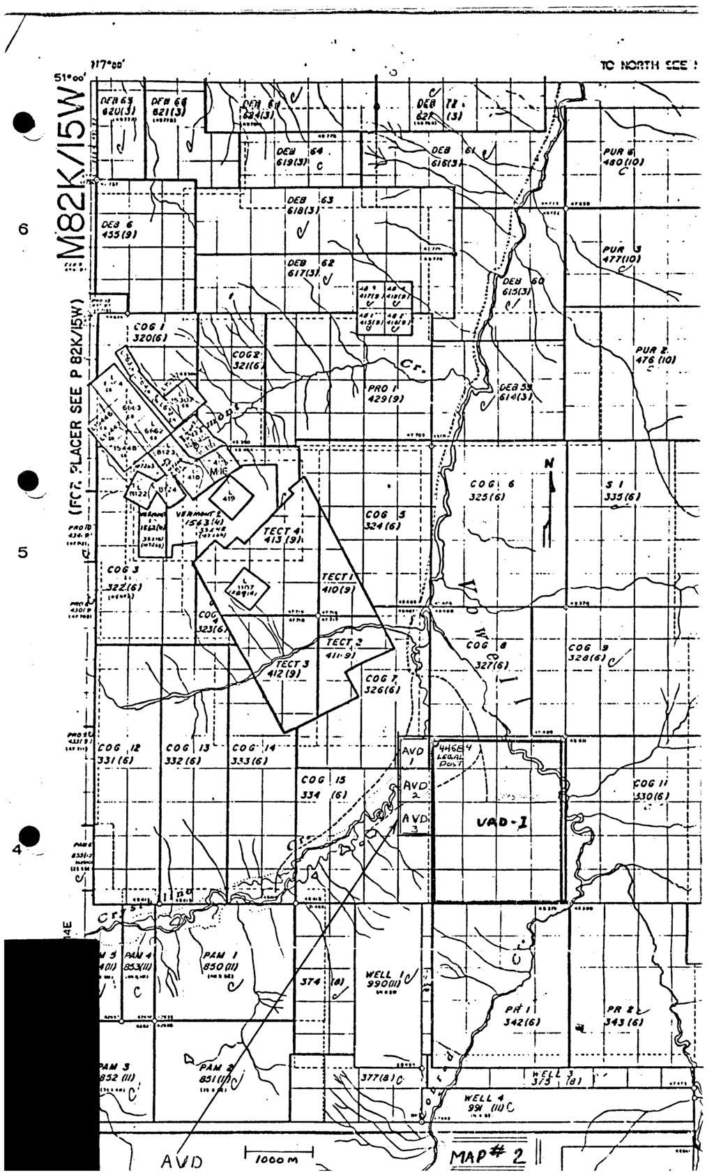
1 ACTION: FItE NO: Including 1990 GEO-CHEM SURVEY RESULTS -- THE AVD CLAIMS - THE GOLDEN MINING DIVISION, GOLDEN, B.C. NTS MAP; M82K/15W Lat. 50 deg. 55 Min. Long 116 deg. 55 min. For GEOLOGICAL BRANCH ASSESSMENT REPORT 12 fl James S. Adamson, done (Operator)- Paid for A ll Work James S. Adamson, Owner of the AVD Claims, _ Calgary, Alberta. Report prepared --- by H. T. Calvert - P. Geol.
2 TABLE - OF CONTENTS PROPERTY... 1 LOCATION AND - ACCESS... 1 ECONOMIC GEOLOGY... 1 GEOLOGY... 1 GEO-CHEM SURVEY... 2 CONCLUSIONS AND - RECOMMENDATIONS INCLUSIONS STATEMENT OF COSTS INDEX MAP - - CLAIM LOCATION MAP GEO-CHEM MAP ASSAY REPORT
3 - 1 - PROPERTY claims. The property consists of three unpatented two post mineral It is known as the AVD Mineral Claims. The above claims are owned by James S. Adamson of Calgary, Alberta. LOCATION AND - ACCESS The claims are located approximately 1500 meters south of the junction of Crystalline and Vowel1 Creeks. The claim area can be reached by 56km of all weather forestry 0 road from Parsons, B.C., which is served by the CPR and highway 95. The property lies on the east slope of the Crystalline Creek valley at an elevation of 1300 to 1800 meters. The property is accessable from the forestry road by 4 wheel drive vehicles, and 300 meters on foot. The claims are timbered and are quite steep. Overburden covers most of the claim area being investigated at this time. ECONOMIC GEOLOGY The AVD Mineral Claims appear to be on strike with the Columbia River Mines Property to the North West which was active and shipped ore during the mid 1970's. GEOLOGY The claims are in the Purcel Range. The area was mapped by J.E. Reesor (G.S.C.) Map 12, 1957, (Lardeau Half).
4 - 2 - The claims are underlain by rock of the Horsethief Creek Series, which consist of argillite, quartzite, pebble conglomerate and limestone of the late Precambrian age. The mineralization appears to have come from a large stock of granodiorite of the Mesozoic age which lies to the southeast. There are a number of folds in the area with dips of approximately 25 degrees. The ore body at the Columbia River Mines lies in a synclinal fold in a limestone band. The AVD claims are almost entirely in heavy forest limiting detailed geology to a few outcrops. 0 GEO-CHEM SURVEY The geo-chem survey on these claims has as its' location line, - the line running north and south between the initial and final posts of AVD -1-. All samples will be west of this line which corresponds to the 750W line of the geo-chem survey grid on the VAD -1- claim to the east. Samples were taken at 10 meter intervals at the west end of the 500m N line, to try and intersect the mineralized zone located on the VAD Claim to the east. The results are shown on map # 4 of this report. All samples were taken from the B - zone at a depth of 20 to 30cm. The samples were all assayed by Loring Laboratories Ltd., located in Calgary, Alberta. An 80 mesh screen was used with all samples. The analysis was done by hot acid digestion and atomic absorption spectroscopy. The sampling was done by James Adamson and Sodi Berar. Standard geo-chem bags were used as supplied by Loring Laboratories All bags were marked and tied at the sample location. All samples were paid for by James Adamson. The samping was done on Aug. 29th, 1990.
5 - 3 - CONCULSIONS - AND RECOMMENDATIONS The geo-chem was done along the west half of the 500m N line of the AVD -1- claim where it was expected to intersect the strike line of the mineralization on the VAD -1- claim. It would appear that the presence of gold values at six sample locations between 380W and 440W seems to bear this out. However as the distance to the last mineralized line on the VAD claim is almost 450m to the south, I would recommend additional geo-chem lines at the 200m, 300m and 400m N intervals to further confirm this extension of the mineralized zone.
6 - 4 - This is to certify that I, H. T. Calvert, 1. Am a resident of Calgary, Alberta, and live at # 1125 Casson Green N.W. T3B 2V6 2. Am a graduate of Brock University in Ontario, B. Sc. in Geology. (1983). 3. Have no interest direct or indirect in the properties known as the AVD Claims Have authorized this report after examination of the field data and the G.S.C. reports pertaining to the area. H. Thomas Calvert, P. Geol.
7 L STATEMENT OF COSTS FOR THE AVD CLAIMS, (3 UNITS) FOR Claims AVD - 3 Units Map -- No. 82K/15W Mi. -- Rec Rec. Nos. 2050, 2051, The above claims were recorded at Golden, B.C. on Sept. 16/89. Geo-Chem Assays... Labor:- Geo-Chem sampling, Hand trenching, hr.. Preparing Report and recording Geo-Chem... Board 2 man per day... Geo-Chem bags and supplies... 4 X per day... Travel in B.C per trip... Total Costs
8 - 6 - SUMMARY OF WORK DONE ON THE AVD CLAIMS FOR A geo-chem survey was done on the northwest end of the AVD claim. The survey line extended from 360 meter W. to 500 meters W. Samples were taken at ten meter intervals to deternmine the gold content in the soils. Some hand trenching was necessary to obtain clay samples below loose rock. 17 samples were taken and analyzed.
9
10

11
12 TO: MR. JIM ADAMSON File No ' th Avenue S.W., Date September 7, 1990 Calgary, Alberga OTZJ lc5 Samples Soil Certificate of Assa LORING LABORATORIES {TD. SAMPLE NO. G32 "GEOCHEMICAL ANALYSES" AVD 340 WEST Middle fallen trees Herebi Certifl that the above. results,are those assays ade by e upon the herein described samples... ejects retained one month. ulps retained one month unless specific arrangements are made in advance. 1Assa ar
13
SELF POTENTIAL SURVEY OVER THE JAY GROUP, INVERMERE AREA GOLDEN MINING DIVISION, BFUTISH COLUMBIA NTS 82W8W7 82W9W LATLONG 50 30' ' FOR
 - GEOLOGICAL SURVEY BRANCH ASSESSMENT REPORTS -- -- DATE RECEI?/::D 06T 10 1996 - SELF POTENTIAL SURVEY OVER THE JAY GROUP, INVERMERE AREA GOLDEN MINING DIVISION, BFUTISH COLUMBIA NTS 82W8W7 82W9W LATLONG
VLF and GRADIOMETER SURVEY OVER THE CAT GROUP, INVERMERE AREA GOLDEN MINING DIVISION, BRITISH COLUMBIA NTS 82K/O8W LAT/LONG 50 29' ' FOR
 VLF and GRADIOMETER SURVEY OVER THE CAT GROUP, INVERMERE AREA GOLDEN MINING DIVISION, BRITISH COLUMBIA NTS 82K/O8W LAT/LONG 50 29' - 116 15' FOR W. POCHYLKO STETTLER, ALBERTA BY T.R.B. DUNDAS ISOGEOS EXPLORATION
RECONNAISSANCE GEOCHEMICAL SURVEY
 RECONNAISSANCE GEOCHEMICAL SURVEY LEGAL, RITA, LOUISE FR. (CHAPLEAU GROUP) REVERTED CROWN GRANTS CHAPLEAU CREEK AREAJ, SLOC& MINING DIVISION 82 F/11W Lat: 49'44" Long: 117"22'W MINERAL RESOURCES BRANCH
Prospecting Report 'S Office i DB Property, B.C. -J Negro Creek Nelson Mining District NTS 82F.050. Operator: Kootenay Gold Inc.
 . '.' I"' i9 12 Prospecting Report 'S Office i DB Property, B.C. -J Negro Creek Nelson Mining District NTS 82F.050 Operator: Kootenay Gold Inc. Owner: Darlene Lavoie Work Performed Summer of 2007 Report
..!I AXE CLAIMS ON THE. for RICHCORE EXPLORATIONS LTO. GREENWOOD MINING DIVISION BRITISH COLUMBIA. Latitude 49O 30"; Longitude 118' 30'W NTS 82E/9W
 ON THE AXE CLAIMS for RICHCORE EXPLORATIONS LTO. GREENWOOD MINING DIVISION BRITISH COLUMBIA Latitude 49O 30"; Longitude 118' 30'W NTS 82E/9W... -... ~ i.,...._.'..!i Vancouver, B.C. September, 1980 P.
Reconnaissance. Of the. Denis mineral claims. Situated at Kilometer 844 of the Alaska Highway. Liard Mining Division. Northeastern British Columbia
 Reconnaissance Of the Denis mineral claims Situated at Kilometer 844 of the Alaska Highway Liard Mining Division Northeastern British Columbia N.T.S. 94M.075 Latitude 59 42 25 Longitude 127 13 12 Field
SOIL GEOCHEMISTRY ENTERPRISE MINE NTS 82 F/14 W ARCTEX ENGINEERING SERVICES CONSULTANT, OWNER, OPERATOR, AUTHOR JANUARY, 1.981
 SOIL GEOCHEMISTRY ENTERPRISE MINE t SLOCAN MINING DIVISION, Bn C, NTS 82 F/14 W LATITUDE 49'49') LONGITUDE 1'19' ARCTEX ENGINEERING SERVICES I L, B, GOLDSMITH, PiENG, CONSULTANT, OWNER, OPERATOR, AUTHOR
1 FILMED 1. FILE NO:!..rsrru -* -. GRAND TWO CLAIM
 FILE NO:!..rsrru -* -. GRAND TWO CLAIM REPORT ON 1993 ASSESSMENT WORK GRAND TWO CLAIM REC. NO. 301849 NELSON MINING DIVISION NTS MAP SHEET 82F6/W 49 25'51" NORTH 117 18'08" WEST 1 FILMED 1 AUTHOR: R. Jordan,
A PRELIMINARY REPORT ON THE ZYMOST2 CLAIM GROtP, TERRACE, B.C.
 NATIVE EXPLORATIONS LTD. A PRELIMINARY REPORT ON THE ZYMOST2 CLAIM GROtP, TERRACE, B.C. INTRODUCTION': The Zymoetz claim group is, at present, held under option by Native Explorations Ltd.. On the 19th
cpw 6. E. Spencer Engineering Ltd. HANNA 9 M. C. 104 REP 0 RT DIAMOND DRILLING PROGRAMME LIARD MINING DISTRICT, K.T.S. FOR TAURUS RESOURCES LTD.
 6. E. Spencer Engineering Ltd. LlJ REP 0 RT ON DAMOND DRLLNG PROGRAMME cpw HANNA 9 M. C. LARD MNNG DSTRCT, K.T.S. 104 P@g FOR TAURUS RESOURCES LTD. BY B. E. SPENCER, P. ENG. B. E. SPENCER ENGNEERNG LTD.
for the Greenwood Mining Division, B.C. NTS 82E/7W Latitude 49' 27' W, Longitude 118' 5 Prepared by a= D. Dylan Watt, B.Sc.
 t. b LOGnO: 37~ -08 m. ACTIO#: for the AMP AMP 2 AMP 3 t AMP 4 CLAIMS Greenwood Mining Division, B.C. NTS 82E/7W Latitude 49' 27' W, Longitude 8' 5 %E c,w zc *& a w Prepared by a= -4c. D. Dylan Watt, B.Sc.
2013 GEOLOGICAL ASSESSMENT REPORT SHERIDAN HILL PROPERTY
 2013 GEOLOGICAL ASSESSMENT REPORT ON THE SHERIDAN HILL PROPERTY NEW WESTMINSTER MINING DIVISION BRITISH COLUMBIA NTS 092G07 49 16 31 NORTH LATITUDE, 122 39 48 WEST LONGITUDE PREPARED FOR Sheridan Hill
RE~ORT ON. J.F.V. MILLAR, P. Eng. GEOCHEMICAL SURVEY TIMBASKET AND MOGUL MINERAL CLAIMS. Kinbasket Lake, B. C. 51 degrees 118 degrees N.E.
 RE~ORT ON GEOCHEMICAL SURVEY TIMBASKET AND MOGUL MINERAL CLAIMS Kinbasket Lake, B. C. 51 degrees 118 degrees N.E. J.F.V. MILLAR, P. Eng. Lease held by J.F.V. MILLAR Work done Sept. 22 - Oct. 3, 1967. REPORT
NTS 082F03SW N W U E N
 Prospecting Report JOCELYN CLAIM NTS 082F03SW N49 09 51 W 117 14 04 11U 482906E 5445737N NELSON MINING DIVISION Martin Ross PO Box 323 Salmo BC V0G 1Z0 Jan 31, 2012 PROSPECTING REPORT JOCELYN MINERAL CLAIM
UNION MINIERE EXPLORATIONS AND MINING CORPORATION LIMITED ASSESSMENT REPORT ON FITINAT MINERAL CLAIM. Alberni Mining Division Record No.
 M F )( UNION MINIERE EXPLORATIONS AND MINING CORPORATION LIMITED Suite 200, 4299 Canada Way, Burnaby, B.C. V5G 1 H4 Telephone (604) 437-9491 ASSESSMENT REPORT ON GEOCHEMICAL SOIL SURVEYS AND ROCKSAMPLING
BALFOUR MINING LTD. (N.P.L.) HAM GROUP 92-P-6, CLINTON M. D.8 B. C. Lat 51 17'N, GEOCHEMICAL REPORT. V. CUKOR, P. Eng.
 HAM GROUP 92-P-6, CLINTON M. D.8 B. C. Lat 51 17'N, GEOCHEMICAL REPORT. V. CUKOR, P. Eng.") 34q '7 BALFOUR MINING LTD. (N.P.L.) HAM GROUP 92-P-6, CLINTON M. D.8 B. C. Lat 51 17'N, Long 12lo14'W GEOCHEMICAL REPORT, V. CUKOR, P. Eng. January 31, 1972 TABLE OF CONTENTS 1. INTRODUCTION 2. PROPERTY,
34q '7 BALFOUR MINING LTD. (N.P.L.) HAM GROUP 92-P-6, CLINTON M. D.8 B. C. Lat 51 17'N, Long 12lo14'W GEOCHEMICAL REPORT, V. CUKOR, P. Eng. January 31, 1972 TABLE OF CONTENTS 1. INTRODUCTION 2. PROPERTY,
3 I1 I I Ill 111 II! II 111 II Ill I IlE I I P I
 -7 3 1 1 11111111111111111111111111111111 ll 111! 111 111 111 111 111111111111111 ll 1111111 1 11111111111111 le P GEOCHEMCAL SURVEY OF THE KE AND D'ARCY CLAM GROUPS.. Similkameen Mining Division, B.C.
58 l'gr'n 'E. Date: January 23, 1979 ASSESSMENT REPORT PLACER SAMPLING & JADE BOULDER EVALUATION PLACER LEASE Liard Mining Divison 1041/7E
 ASSESSMENT REPORT PLACER SAMPLING & JADE BOULDER EVALUATION PLACER LEASE 1711 Liard Mining Divison 1041/7E 58 l'gr'n 18 38'E Owner & operator: Cry Lake Jade Mines Ltd. Author: A.M. Homenuke, P.Eng. Date:
49" 3-4 I4 I \ Y 59 tj
 ASSESSMENT REPORT Mary 4 FORT STEELE M.D. NTS 82G/5W 49" 3-4 4 \ Y 59 tj Owner: St. Eugene Mining Corporation Limited Operator : St. Eugene Mining Corporation Limited Author: John R. Wilson Date Submitted:
GRANGES EXPLORATION AB CANADIAN DIVISION
 GRANGES EXPLORATON AB CANADAN DVSON GEOCHEMCAL REPORT ON "B" and "D" CLAMS OMNECA MNNG DEVSON FAWNE NOSE AREA LATTUDE: 53O 19' LONGTUDE: 125O 1' MNERAL RESOURCES BRANCH N.T.S 93F/6 E Owner and Operator
NTS 93L/9W GEOCHEMICAL AND GEOPHYSICAL REPORT MONA CLAIM OMINICA MINING DIVISION. Lati tude 54036'N; Longitude 'W
 GEOCHEMICAL AND GEOPHYSICAL REPORT ON MONA CLAIM OMINICA MINING DIVISION Lati tude 54036'N; Longitude 126018'W NTS 93L/9W April 1981 Paul Plicka Consulting Geologist LOCATION MAP INTRODUCTION TABLE OF
GEOLOGICAL BRANCH ASSESSMTNF REPORT
 A GEOCHEMICAL REPORT on the 49 CR. GROUP APPROX. 9 mi SW OF NELSON, B.C 49 CREEK AREA NELSON NINING DIVISION BRITISH COLUNBIA NINERAL CLAIM MAP N. T.S. 82-~/6 WEST LATITUDE$ 49' 27'~ LONGITUDE : 117' 2j0w
EXPLORATION and DEVELOPMENT REPORT. Conrad Creek. PLACER and MINERAL CLAIMS SOUTHEAST BRITISH COLUMBIA
 EXPLORATION and DEVELOPMENT REPORT on Conrad Creek PLACER and MINERAL CLAIMS in SOUTHEAST BRITISH COLUMBIA Ed Friesen, BSc.E.E., P. Eng 8 Lake Placid Rise SE Calgary, Alberta T2J 5B5 April 2009 1 P age
J.D. Mason, Prof. Engineer. Report on the Reconnaissance Magnetometer Survey. Completed for. North American Platinum Corporation Ltd.
 Report on the Reconnaissance Magnetometer Survey Completed for North American Platinum Corporation Ltd. Olivine Mountain Property, Tulameen, B.C. J.D. Mason, Prof. Engineer. November 28, 1967. Certificate
ASSESShAENT REPORT Mines and Petroleum Resources. Department of. No* JIMMY MINERAL CLAIM FRANKLIN CREEK AREA, GREENWOOD M. D.
 GEOCHEMICAL REPORT ON JIMMY MINERAL CLAIM FRANKLIN CREEK AREA, GREENWOOD M. D. Lat. 49'35' OON, N.T.S. Long. 118O22' 00W 82-E-9 July 18-21, 1974 Vancouver, B.C. J.J. McDougall, P.Eng. July 21, 1974 * Department
ASSESSMENT REPORT TITLE PAGE AND SUMMARY
 ASSESSMENT REPORT TITLE PAGE AND SUMMARY TITLE OF REPORT: 2016 Prospecting Report Sphynx Claim TOTAL COST: $167.56 AUTHOR(S): Giacomo Grassi SIGNATURE(S): NOTICE OF WORK PERMIT NUMBER(S)/DATE(S): STATEMENT
_.----." 2) Gravimetric Profiles... In Pocket TABLE OF CONTENTS PAGE - SUMMARY AN0 CONCLUSIONS... 1A GRAVIMETRIC SURVEY Field Procedures...
 Gravimetric Profiles... In Pocket TABLE OF CONTENTS PAGE - SUMMARY AN0 CONCLUSIONS... 1A GRAVIMETRIC SURVEY Field Procedures...") _.----." TABLE OF CONTENTS PAGE - SUMMARY AN0 CONCLUSIONS... 1A GRAVIMETRIC SURVEY... 1 Field Procedures... 1 Elevation and Horizontal Control... 2 Meter Procedures... 2 Computing Procedures... 2 Plotting...
_.----." TABLE OF CONTENTS PAGE - SUMMARY AN0 CONCLUSIONS... 1A GRAVIMETRIC SURVEY... 1 Field Procedures... 1 Elevation and Horizontal Control... 2 Meter Procedures... 2 Computing Procedures... 2 Plotting...
Date Submitted: June General Nature of Report: Examination of Placer Samples
 General Nature of Report: Examination of Placer Samples Claim: Gold Channel, Record Number 3775!8 1 (Gold Channel Placer Property) Mining Division: Cariboo NTS 093 G 09 W and E Latitude 520 23 N' Longitude1210
PERCY CONTRACTING SERVICES LTD.
 GEOLOGICAL REPORT ON TEN PLACER LEASES (3139, 3140, 3141, 3142, 3143, 3144, 3145, 3146, 3147, 3148) MOREHEAD CREEK CARIB00 MINING DIVISION, B.C. 938/12W (52 38 N, 121 47 W) For PERCY CONTRACTING SERVICES
REPORT ON A GEOLOGICAL MAPPING AND PROSPECTING PROGRAM LOOK PROPERTY
 b KOKANEE EXPLORATIONS LTDI I WNO. 0 I- n c/ REPORT ON A GEOLOGICAL MAPPING AND PROSPECTING PROGRAM LOOK PROPERTY LOOK 1-31, 36-43 CLAIMS FORT STEELE MINING DIVISION CRANBROOK AREA N.T.S. 82G/5W + 4E E:
GEOPHYSICAL REPORT CHU CHUA PROJECT Green Mountain Group. KAMLOOPS MINING DIVISION NTS 92P/8E, 82M/5W Lat: 51'24' N Long: 120'00' w
 I GEOPHYSICAL REPORT CHU CHUA PROJECT Green Mountain Group KAMLOOPS MINING DIVISION NTS 92P/8E, 82M/5W Lat: 51'24' N Long: 120'00' w I rvm #.,_..._..._._._.- $...-...! 1 VANCOUVER, B.C. 1 G E 0 I, 0.G
I PRELIMINARY MAGNETOMETER SURVEY
 .REPORT O N I PRELIMINARY MAGNETOMETER SURVEY and GEOLOGICAL RECONNAISSANCE L AND K GROUP OF CLAIMS Located 8 Miles East of Princeton, B. C. Similkameen Mining Division Lat. 49' 27' N. Long. 120' 16' W
REPORT ON APPLICATION TO RECORD WORK. on the CLAIM GROUP. BY Owners. issued at Penticton, B.C. Jan 19,1976. issued at Rossland B.C. Jan.
 --.. REPORT ON APPLICATION TO RECORD WORK on the CLAIM GROUP 1976 2133 meters North-North-East Okanagan I- Falls Post Office 0,// --7 L Lat. 493 21 N., Long. 119 33 W
Lat. 52' 43' N Long ' W
 &A exploration ltd MINING ENGINEERING GEOLOGY- GEOPHYSICS 4570 HOSKINS ROAD, NORTH VANCOUVER, 6. C. TELEPHONE (804) 985,7921 V7K 2R1 GEOLOGICAL AND GEOCHEMICAL REPORT on the BLUE CLAIMS Cariboo Mining
7 MILES WEST OF PORT HARDY, B.C.
 GEOPHYSICAL REPORT VERTICAL INTENSITY MAGNETOMEER SURVEY ON LUK CLAIMS, 7 MILES WEST OF PORT HARDY, B.C. 50' 127O SE BY R. E. SHIELDS UNDER SUPERVISION OF J. R. BILLINGSLEY FOR SECOND0 MINING LTD. (N.
ASSESSMENT REPORT GEOLOGICAL BRANCH. 50' 23 'North. GEOLOGICAL and GEOCHEMICAL SURVEYS ON THE. PUTNAM PROPERTY (Putnam Mineral Claim)
") GEOLOGICAL and GEOCHEMICAL SURVEYS ON THE PUTNAM PROPERTY (Putnam Mineral Claim) VERNON MINING DIVISION, B.C. GEOLOGICAL BRANCH ASSESSMENT REPORT NTS : Latitude: 82L17W 50' 23 'North LOCATION, ACCESS,
GEOLOGICAL and GEOCHEMICAL SURVEYS ON THE PUTNAM PROPERTY (Putnam Mineral Claim) VERNON MINING DIVISION, B.C. GEOLOGICAL BRANCH ASSESSMENT REPORT NTS : Latitude: 82L17W 50' 23 'North LOCATION, ACCESS,
ASSESSMENT REPORT ON THE PEAVINE PROJECT. DGW & Associates # Alberni Street, Vancouver, British Columbia, V6E 4V2
 ASSESSMENT REPORT ON THE PEAVINE PROJECT KAMLOOPS MINING DIVISION BRITISH COLUMBIA NTS 082M 12 Latitude 51 36' 19.0"North -- Longitude --119 47' 27.0"West UTM Zone 11, NAD 83 5720827N 306744E Prepared
GEOLOGICAL BRAN ASSESS
 TITLE PAGE This report covers assessment work performed on the Mundy group, located in the Boundary Creek area, north of Greenwood, British Columbia. The work comprises of THM soil testing, trenching and
GEOLOGICAL MAPPING REPORT ON THE ASH MINERAL CLAIM OSOYOOS MINING DIVISION ASHNOLA RIVER MAP SHEET NTS M092,H019 MCBRIDE CREEK AREA, ASHNOLA RIVER,
 GEOLOGICAL MAPPING REPORT ON THE ASH MINERAL CLAIM OSOYOOS MINING DIVISION ASHNOLA RIVER MAP SHEET NTS M092,H019 LATITUDE 49 o O6, LONGITUDE 120 o 22 MCBRIDE CREEK AREA, ASHNOLA RIVER, KEREMEOS, B.C. CANADA
Cominco ltd. REPORT OF GRID "C" GEOCHEMICAL SURVEY ON VINE 1 CLAIM, VINE 1, 25, 27 CLAIM GROUP Fort Steele Mining Division
 GOVERNMENT OFFICE Cominco ltd. EXPLORATION DIVISION REPORT OF GRID "C" GEOCHEMICAL SURVEY ON VINE 1 CLAIM, VINE 1, 25, 27 CLAIM GROUP Fort Steele Mining Division Submitted by: E.W. BATCHELOR Cominco Ltd.
PRECIOUS METALS. owner. JMT Services Corp. GEOCHPlICAL SAMPLING CHELASLIE WCE, NORTH CENTRAL, B.C. OMINECA MINING DIVISION NTS 93F/5E & 6W
 PRECIOUS METALS REPORT ON 1980 RECONNAISSANCE GEOCHPlICAL SAMPLING CHELASLIE WCE, NORTH CENTRAL, B.C. OMINECA MINING DIVISION NTS 93F/5E & 6W LATITUDE 53O28 N LONGITUDE 125O31 W DATES Qp WORK: JULY 10
PROSPECTING REPORT. re. Minera.1 C laims
 PROSPECTING REPORT re. Minera.1 C laims P R 1 Record #3052 (6) P R 2 Record #3053 (6) p R 3 Record #3054 (6) at Ilong.129, Latt. 58 20' in the Two Mile Creek area of Turnagain River drainage system in
32?un North of Hope, B.C.,
 Geological Reconnaissance Assessment Report on portions of the Gilt Creek Group (Mike, C.G., Julie, and Gilt Mineral Claims) Situated 32?un North of Hope, B.C., New Westminster Mining Division N 'P 97H/11W
GEOCSZNICAL - SURVEY. ICAMLOOPS Kl.D. 2'' 6;kr. HY "'f. Alfred R. Allen,P.Eng. 1 NO.%=...,... 6"- 'I.
 t i.i GEOCSZNICAL - SURVEY i p' ICAMLOOPS Kl.D. 2'' 6;kr HY 50-64 +."'f 121-51 NE 5-10-70 : 19-10-70 Alfred R. Allen,P.Eng. I) ' 1 6"- 'I. 1 NO.%=...,..... Q.C. EXPLORATIONS LTD. 2Cl- 535 Kowe Street Vancouver
PROSPECTORS ASSISTANCE PROGRAM MINISTRY OF ENERGY AND MINES
 BRITISH COLUMBIA PROSPECTORS ASSISTANCE PROGRAM MINISTRY OF ENERGY AND MINES GEOLOGICAL SURVEY BRANCH PROGRAM YEAR: 1999/2000 REPORT #: PAP 99-l 6 NAME: KIM ANSCHETZ PROSPECTORS TlEPORT on the 99 LOUIS
Survey. Prospecting, Geological Mapping. and E-M GOLDEN MINING DIVISION. Report on. RAD Mineral Claims. NTS Location - 82K/8W
 GOLDEN MINING DIVISION Report on Prospecting, Geological Mapping and E-M Survey RAD Mineral Claims NTS Location - 82K/8W Coordinates 116O 20' W, 50 20' N Operator - Cochrane Oil & Gas Ltd. Author - R.G.
ASSESSMENT REPORT TITLE PAGE AND SUMMARY
 ASSESSMENT REPORT TITLE PAGE AND SUMMARY TITLE OF REPORT: 2016 Prospecting Report Midas Claim TOTAL COST: $314.61 AUTHOR(S): Giacomo Grassi SIGNATURE(S): NOTICE OF WORK PERMIT NUMBER(S)/DATE(S): STATEMENT
Golden Predator Intersects 6.86 m of g/t Gold at the 3 Aces Project; Jack and Ace of Spades Zones Merging
 NEWS RELEASE TSX.V: GPY July 10, 2017 NR 17-15 www.goldenpredator.com Golden Predator Intersects 6.86 m of 20.15 g/t Gold at the 3 Aces Project; Jack and Ace of Spades Zones Merging Vancouver, BC, July
PHYSICAL WORK REPORT ON THE. KINGDOMlwINERAL LILLOOET MINING DIVISION. NTS Map Sheet 92J/15W. Co-Ordinates North: East
 PHYSICAL WORK REPORT ON THE KINGDOMlwINERAL CLAIM LILLOOET MINING DIVISION NTS Map Sheet 92J/15W Co-Ordinates North: 50 48 East 120 48 For Assessment Work BY Edward Skoda October 15,2002 Vancouver, British
ASSESSMENT REPORT MAGNETOMETER SURVEY GOLDEN ROD, GOLDEN ROD #2. Long.: General Delivery, Vananda, B. C.
 ASSESSMENT REPORT MAGNETOMETER SURVEY GOLDEN ROD, GOLDEN ROD #2 t=/ NTS 92~110w Lat.: Long.: 49O 44' N 124O 34' W Owner: E. Johanson General Delivery, Vananda, B. C. Operator: Rhyolite Resources I nc.
BGND 2-7 CLAIMS, KELOWNA, B.C.
 GEOLOGICAL EVALUATION of BGND 2-7 CLAIMS, KELOWNA, B.C. 5"'33"N; 9"33'3"W:NTS 82L/4E BEAR CREEK: 4Km NNW of Kelowna Vernon Mining Div., British Columbia by N. C., P.Geol., P. Eng. Consulting Geologist,
on the Diamond Drilling done on the LAKESIOE GROUP of Mineral Claims SLOCAN MINING DIVISION 82-F-14-W Long ' Lat '
 Assessment Work Report on the Diamond Drilling done on the LAKESIOE GROUP of Mineral Claims SLOCAN MINING DIVISION 82-F-14-W Long 117 22' Lat. 49 58' ADRIAN KESLER SILVERTON, B.C. operator LEVON RESOURCES
PROSPECTING REPORT. Broken Hill Property. EVENT # TENURE # Tenure Name: Broken Hill. New Westminster Mining Division Map 092H
 2009-2010 PROSPECTING REPORT Broken Hill Property EVENT # 4514071 TENURE # 600988 Tenure Name: Broken Hill New Westminster Mining Division Map 092H Central Coordinate Reference 121 24 26.2 W Longitude
EWS PETROLEUM CORPCWAT~ WEST HASTINGS STREET VANCOUVER, 8. C. V6C 186
 EWS PETROLEUM CORPCWAT~ 613-837 WEST HASTINGS STREET VANCOUVER, 8. C. V6C 186 GEOPHYSICAL REPORT on a VLF - ELECTROkAGNETlC SURVEY on the SHEBA MINERAL CLAIM CARIBOO MINING OIVISION NTS 93 H/3 Lat. 53
121 deg 44' W and 53 deg 07' N
 M.R. #. R... VANCOUVER, B.C. REPORT ON THE WILLOW AND WILLOW I CLAIMS RECORD NO. 8475 AND 8476 CARIBOO MINING DIVISION NTS 93 H/4 121 deg 44' W and 53 deg 07' N 'W OWNER AND OPERATOR: RUZA RESOURCES LTD.
GEOPHYSICAL REPORT ON AN INDUCED POLAR.IZATION SURVEY
 GEOPHYSICAL REPORT ON AN INDUCED POLAR.IZATION SURVEY T & V Claim Groups some 12 miles Northwest of Babine Lake, B.C. Latitude 55' 26'N Longitude 126' 35'W AUTHOR: Glen E. White, Chief Geophysicist,a,
1 CLAIMS GEOPHYSICAL REPORT ON BOYAL SITUATE NORTHEAST OF TILLICUM MOUNTAIN GOLD AREA BURTON - NAKUSP SIQCAEJ MINING DIVISION
 GEOPHYSICAL REPORT ON BOYAL 1 CLAIMS SITUATE NORTHEAST OF TILLICUM MOUNTAIN GOLD AREA BURTON - NAKUSP SIQCAEJ MINING DIVISION CONSULTING GEOLOGIST AUGUST 1983 VANCOUVER B *C INDEX INTRODUCTION ooa,.eoaaa.aaaoaaooaoa~ao~o
N. T G/12 Cranbrook
 Boulder Creek Road Exploration Project Cranbrook, B. C. Soil Sampling Programme Fort Steele Mining District N. T. 9. 82 G/12 Cranbrook Placer Leases Ole I1 PC-21 P61697 Ole I2 PC-20 P61696 Ole (3 PC-66
A REPORT. Bear Lake, British Columbia (56' 13'N, ~) N.T.S. 94 D U& Claims surveyed: BL 1, units 2
 N.T.S. 94 D U& Claims surveyed: BL 1, units 2") I PETER E. WALCOTl' Rr ASSOC. LTD. A REPORT AN INDUCED POLARIZATION SURVEY T.?. d." Bear Lake, British Columbia rnk (56' 13'N, 1270 49~) N.T.S. 94 D U& *o Claims surveyed: BL 1, units 2 *a* & 3 BL 2, units
I PETER E. WALCOTl' Rr ASSOC. LTD. A REPORT AN INDUCED POLARIZATION SURVEY T.?. d." Bear Lake, British Columbia rnk (56' 13'N, 1270 49~) N.T.S. 94 D U& *o Claims surveyed: BL 1, units 2 *a* & 3 BL 2, units
PHYSICAL WORK REPORT. the BAY CLAIMS. Omineca Mining Division Smithers, British Columbia N.T.S. 93E 13E/W
 PHYSICAL WORK REPORT the BAY CLAIMS Omineca Mining Division Smithers, British Columbia a N.T.S. 93E 13E/W LATITUDE: 53 57 00 N I LONGITUDE: 127 45 OO W for Home Ventures Ltd. 1201-675 West Hastings Street
---.,- A.S. ASH'TON, P. ENG. Delta, B.C. REPORT AMORE GROUP VICTORIA MINING DIVISION 32 KM S.S.W. OF NANAIMO, B.C. N.T.S.
 REPORT ON AMORE GROUP VICTORIA MINING DIVISION 32 KM S.S.W. OF NANAIMO, B.C. LATITUDE 48O57' N LONGITUDE 124O18' W N.T.S. 92C/16 W FOR AQUARIUS RESOURCES LTD. 11450-124 Street, Edmonton, Alberta. T5M OK3
We are committed to providing accessible customer service. If you need accessible formats or communications supports, please contact us.
 We are committed to providing accessible customer service. If you need accessible formats or communications supports, please contact us. Nous tenons à améliorer l accessibilité des services à la clientèle.
PROSPECTING REPORT. Deneau Creek. EVENT # TENURE # Tenure Name: Deneau Creek. New Westminster Mining Division Map 092H
 2010-2011 PROSPECTING REPORT Deneau Creek EVENT # 4844921 TENURE # 578616 Tenure Name: Deneau Creek New Westminster Mining Division Map 092H Central Coordinate Reference 121 18 04.5 W Longitude 49 26 13.9
REPORT ON MAGNETOMETER SURVEY TIK-1 CLAIM e&f KAMLOOPS MINING DTVISION. by D. Hendry D. C. MILLER. February 3, for
 REPORT ON MAGNETOMETER SURVEY TIK-1 CLAIM 92-1-14 e&f KAMLOOPS MINING DTVISION lat. 50 57 ' 12" long. 121O23 ' 37" OWNER: ST. JOSEPH EXPLORATIONS LIMITED OPERATIOR: ST. JOSEPH EXPLORATIONS LIMITED by D.
490 20' 30" North Latitude ' 30" West Longitude
 _._.. I CONSULTING GEOLOGISTS 605-602 WEST HASTINGS STREET, VANCOUVER, B.C. V6B 1P2 TELEPHONE: (604) 689-5533 6 I F: ASSESSMENT REPORT ON THE PATSY 1 MINERAL CLAIM ' '?%2% I WHISTLE CREEK, HEDLEY ARE L-l-
NEW HAZELTON, OMINECA M.D.,
 PROSPECTING REPORT JUDI 1 TO 6 MINERAL CLAIMS NEW HAZELTON, OMINECA M.D., B.C. MAP 93M/4E, LAT. SS014'N, LONG. 127'33'W OWNED BY: A. L'ORSA ANTHONY L'ORSA Smithers, B.C. 21 February, 1981 TABLE OF CONTENTS
REPORT OF GEOLOGICAL MAPPING ON THE MICHEL COAL LICENSE #5177. LOCATION: KOOTENAY LAND DISTRICT NTS 82-G-7 4Y028 Lat f Long.
 i *. REPORT OF GEOLOGICAL MAPPING ON THE MICHEL COAL LICENSE #5177 LOCATION: KOOTENAY LAND DISTRICT NTS 82-G-7 4Y028 Lat. 114 40f Long. ESSO RESOURCES CANADA LIMITED WARD E. KILBY WORK: OCTOBER 17 - OCTOBER
Report of Gridding and Magnetic Surveys. On the. Munro Property. Munro and Beatty Townships, Ontario. Larder Lake Mining Division
 Report of Gridding and Magnetic Surveys On the Munro Property Munro and Beatty Townships, Ontario Larder Lake Mining Division Claims: 39 4244 For Big Red Diamond Corporation October 3, 2 Timmins, Ontario
SUMMARY REPORT. RE-ESTABLISH CLAIM BOUNDARY (Claim ) CARR TOWNSHIP (Larder Lake Mining Division) NTS (42 Al09) FOR
 CARR TOWNSHIP (Larder Lake Mining Division) NTS (42 Al09) FOR") 2.44330 " SUMMARY REPORT RE-ESTABLISH CLAIM BOUNDARY (Claim 3002288) CARR TOWNSHIP (Larder Lake Mining Division) NTS (42 Al09) FOR ST ANDREW GOLDFIELDS LTD. ""'1,.I Les 1. Kovacs, P. Geo For: St Andrew
2.44330 " SUMMARY REPORT RE-ESTABLISH CLAIM BOUNDARY (Claim 3002288) CARR TOWNSHIP (Larder Lake Mining Division) NTS (42 Al09) FOR ST ANDREW GOLDFIELDS LTD. ""'1,.I Les 1. Kovacs, P. Geo For: St Andrew
for the Greenwood Mining Division, B.C. NTS 82E/7W 29' W, Longitude 118' 53' N Prepared by D. Dylan Watt, B.Sc.
 for the FltE NO: u VOLT 1, VOLT 2, VOLT 3, & VOLT 4 CLAIMS Greenwood Mining Division, B.C. NTS 82E/7W Latitude 49' 29' W, Longitude 118' 53' N Prepared by D. Dylan Watt, B.Sc. #309-1996 Trutch Street Vancouver,
4. Geological maps published by the Ontario Department of Mines.
 52J08NWei45 S2J08NWa6B1 SMYE 010 AMALGAMATED RARE EARTH MINES LTD. *, SAVANT LAKE PROSPECT x ONTARIO INTRODUCTION t This Is a report on a group of 28 claims control led by Amalgamated Rare Earth Mines
GEOPHYSICAL REPORT. Airborne Magnetometer Survey. of the SHEEP-GOAT GROUP OF MINERAL CLAIMS. near Li l looet, B.C.
 GEOPHYSICAL REPORT 977 Airborne Magnetometer Survey of the SHEEP-GOAT GROUP OF MINERAL CLAIMS near Li l looet, B.C. Lillooet Mining Division (Lat.51 'lot Long. 122 40' 7 5t0[2L05E. for DUFFEY LAKES MINES
PHOENIX GEOPHYSICS LIMITED REPORT ON THE VLF-EM AND TOTAL FIELD MAGNETOMETER SURVEYS ON THE
 PHOENIX GEOPHYSICS LIMITED REPORT ON THE VLF-EM AND TOTAL FIELD MAGNETOMETER SURVEYS ON THE TAN CLAIMS, CHILLIWACK AREA NEW WESTMINSTER MINING DIVISION, BRITISH COLUMBIA FOR LORNEX MINING CORPORATION LIMITED
L FILMED I GEOLOGICAL BRANCH ASSESSMENT REPORT. on the. in the. A Geological Report. situated. Nelson Mining Division
 A Geological Report on the GOV 5 Claim situated 4 km north of Creston, B.C. in the Nelson Mining Division N.T.S. 82pF/7tEf Lat: 49m1 N Long: 116'4.5'W 24.8' Dates of Work: 11-1 September 1986 Date of Report:
PROSPECTING REPORT THE WALLACE CLAIM OMENICA MINING DIVISION. 54" x6" 3.d d. for. Reako Exlorat ions Ltd. Wallace Rev. C.G.
 PROSPECTING REPORT ON THE WALLACE CLAIM OMENICA MINING DIVISION 54"44 14 1x6" 3.d d by David A. Howard P.Eng. for Reako Exlorat ions Ltd. Claim Locat ion Wallace Rev. C.G. #1560 Dome Mountain Area 9 3
A Report on a Magnetometer Survey. Division, British Columbia. Gypsy 1-32 and Gypsy 1 Fr-9 Fr. 27 miles north of Smithers
 - A Report on a Magnetometer Survey on the Gypsy Claims, Omineca Mining Division, British Columbia Covering: Gypsy 1-32 and Gypsy 1 Fr-9 Fr Located: 27 miles north of Smithers Latitude 55O11' N Longitude
FILE NO. ASSESSMENT REPORT VLF-EM GEOPHY S I CS BUCK CLAIMS. Moyie River and Perry Creek Area FORT STEELE MINING DIVISION. NTS 82 F/8 E and 82 G/5 W
 FILE NO. ASSESSMENT REPORT on - VLF-EM GEOPHY S I CS BUCK CLAIMS Moyie River and Perry Creek Area FORT STEELE MINING DIVISION NTS 82 F/8 E and 82 G/5 W Latitude 49 27' N Longitude 116 03' W PETER KLEWCHUK
41,a* h0.iiii*bll*i2l,i DEADWOOD CREEK. for. James R. on the BOMBINI GROUP OF CLAIMS. GREENWOOD, British Columbia. Lat. 49'07' Long. 118'43 f.
 GEOLOGCAL REPORT on the BOMBN GROUP OF CLAMS DEADWOOD CREEK GREENWOOD, British Columbia Lat. 49'07' Long. 118'43 f in the GREENWOOD MNNG DVSON for FURY EXPLORATONS LTD. (N. P. L. ) Vancouver, B. C. December
REPORT SOIL GEOCHEMICAL SURVEY. ATTYCELLEY NO. 2 GROUP (Attycelley Mineral Claims No. 7-10)
") REPORT SOIL GEOCHEMICAL SURVEY ATTYCELLEY NO. 2 GROUP (Attycelley Mineral Claims No. 7-10) Situated 7 miles east of north end of Thutade Lake, Omineca Mining Division British Columbia I Department of I
REPORT SOIL GEOCHEMICAL SURVEY ATTYCELLEY NO. 2 GROUP (Attycelley Mineral Claims No. 7-10) Situated 7 miles east of north end of Thutade Lake, Omineca Mining Division British Columbia I Department of I
Gold Mountain Group Gold Mtn. A, B, C & D Mineral Claims Record Nos. 697, 698, 699 & 700. Island Mountain Cariboo Mining Division British Columbia
 GOLD POINT RESOURCES LTD. Geophysical Survey Gold Mountain Group Gold Mtn. A, B, C & D Mineral Claims Record Nos. 697, 698, 699 & 700 Island Mountain Cariboo Mining Division British Columbia Vancouver,
Amboy Iron Mines, Bristol Mountains, San Bernardino County, California. Gregg Wilkerson 2017
 Amboy Iron Mines, Bristol Mountains, San Bernardino County, California Gregg Wilkerson 2017 Acknowledgement and Disclaimer The information in this paper is taken largely from published sources. I have
RECONNAISSANCE GEOPHYSICAL SURVEY HELICOPTER - BORNE V. L.F. ELECTROMAGNETIC AND MAGNETIC GALLOWAY AREA FORT STEELE M.D., B.C.
 RECONNAISSANCE GEOPHYSICAL SURVEY HELICOPTER - BORNE V. L.F. ELECTROMAGNETIC AND MAGNETIC GALLOWAY AREA FORT STEELE M.D., B.C. Balsam 1-4 & 5-12 Cedar 1 & 2 Cedar South 1 & 2 Elderberry 1 Elderberry South
Geochemical Assessment Report. on the. Situated Nineteen Kilometres rth-northeast of Hope, B. C. in the. New Westminster Mining Division
 7 I Geochemical Assessment Report r on the r- I 1 Norm 1 to Norm 4 Mineral Claims c - I - 7 Situated Nineteen Kilometres rth-northeast of Hope, B. C. in the New Westminster Mining Division itude 49*32'N.,
'-7' REPORT ON A MAGNETOMETER SURVEY OVER PART OF THE MAX CLAIM GROUP 1-20 LAC LE JEUNE AREA KAMLOOPS MINING DIVISION KAMLOOPS, BRITISH COLUMBIA
 I,., - SUITE 102. 222 BELLEVUE WES t ANCOUVER, B. '-7' REPORT ON A I MAGNETOMETER SURVEY OVER PART OF THE MAX CLAIM GROUP 1-20 LAC LE JEUNE AREA KAMLOOPS MINING DIVISION KAMLOOPS, BRITISH COLUMBIA 50-30
sq N & %%.& GEOPHYSICAL CONSULTING rr SERVICES LTD. $%& Long. 118o3OtW N.T.S. 82 E/15 -I- AUTROR: Glen E. Whi*e, B.Sc., P. %g.
 -\ GEOCHEMICAL EXPORT.,~.,~..'.. AMORE MINERALS 1NCORPOR;ITZC,' ~. 3rd fl5 Geo 3. and 2 mineral claims, Vernon- ~ $lining Division, B. C. Lat. 49 47'T?,,/ Long. 118o3OtW N.T.S. 82 E/15 -I- AUTROR: Glen
51 46'N Latitude, 119'44'1;!
 COMI)!CO LTD. EXPLORATION NTS: 82 1'1/13E GEOCHEKICAL ASSESSMENT REPORT ON THE SI 1 MINERAL CLAIM in the Kamloops Mining Division 51 46'N Latitude, 119'44'1;! Longitude Work Period: June 25, 1979 - July
SPUZZUM CREEK AREA PROSPECTING REPORT. on the NTS 92H/12E. Lat. 49" 44' Long. 121" 43' for H.J. Forsyth & J.D.
 PROSPECTING REPORT on the WREN GROUP of MINERAL CLAIMS SPUZZUM CREEK AREA NEW WESTMINSTER MINING DIVISION NTS 92H/12E Lat. 49" 44' Long. 121" 43' for H.J. Forsyth & J.D. Murphy Owners by Jay 0. Murphy,
Magnetic Field and VLF Surveys on the Shining Tree Property. Claims: , , , , , , , ,
 December 29, 2014 NTS: 041P11 Magnetic Field and VLF Surveys on the Shining Tree Property Claims: 1203361, 4251801, 4251803, 4251805, 4263067, 4263068, 4270940, 4270436, 4276740 Churchill and Asquith Townships
CONSULTING GEOLOGICAL 8: MINING ENGINEERS STINGS STREET DA V6E 2E9 GEOPHYSICAL SURVEY SILVER QUEEN 2 ZEBALLOS AREA. B.C.
 DOLMAGE CAMPBELL & ASSOCIATES (1 975) LTD. CONSULTING GEOLOGICAL 8: MINING ENGINEERS STINGS STREET DA V6E 2E9 '' 1E O L 0 G I C A.L B'x;&a:f2:#& 'SESSMENT REPObT 12, Assessment RESOURCES LTD. 111 ReDort
SOIL GEOCHEMISTRY. OK-ll AND OK-Ill MINERAL CLAIMS MOUNT THOEN AREA OMINECA MINING DIVISION, B.C. NTS 93 MI6 E & 7 W
 SOIL GEOCHEMISTRY OK-ll AND OK-Ill MINERAL CLAIMS MOUNT THOEN AREA OMINECA MINING DIVISION, B.C. NTS 93 MI6 E & 7 W LATITUDE 55O23'N, LONGITUDE 127 01W Locke B. Goldsmith, P.Eng. Consulting Geologist December
We are committed to providing accessible customer service. If you need accessible formats or communications supports, please contact us.
 We are committed to providing accessible customer service. If you need accessible formats or communications supports, please contact us. Nous tenons à améliorer l accessibilité des services à la clientèle.
R.A. COMINCO LTD. EXPLORATION NTS: 92H/16. WESTERN DISTRICT January 6, 1982 ASSESSMENT REPORT 1981 SOIL GEOCHEMISTRY ON THE TROUT PROPERTY
 COMINCO LTD. EXPLORATION NTS: 92H/16 WESTERN DISTRICT January 6, 1982 ASSESSMENT REPORT 1981 SOIL GEOCHEMISTRY ON THE TROUT PROPERTY (Trout 1 and 6 Claims) SIWASH LAKE AREA, SIMILKAMEEN M.D., B.C. (Work
ASSESSMENT REPORT PROSPECTING PROGRAM ION/DIRTY JACK PROPERTY NELSON MINING DIVISION N.T.S. MAP SHEET 82F.023 UTM COORDINATES N E
 ASSESSMENT REPORT PROSPECTING PROGRAM ION/DIRTY JACK PROPERTY NELSON MINING DIVISION N.T.S. MAP SHEET 82F.023 UTM COORDINATES 5454800N - 0455235E Work Performed Summer 2007 OWNER >* ' Tom Kennedy >8 404-22
ON THE LOST GOLD PROPERTY
 ON THE LOST GOLD PROPERTY NELSON MINING DIVISION BRITISH COLUMBIA Latitude: 49 18 North Longitude: 117 29.West TRIM MAPS: 82F1023,033 NTS: 8tF/5,6 By: Fred Critchlow . TABLE OF CONTENTS r PAGE lutroduction
GEOPHYSICAL ASSESSMENT REPORT (TOP & BOTTOM CLAIMS) MCINTYRE LAKE. VERNON MINING DIVISION, B-Cm
 MCINTYRE LAKE. VERNON MINING DIVISION, B-Cm") GEOPHYSICAL ASSESSMENT REPORT on the TOP PROPERTY (TOP & BOTTOM CLAIMS) MCINTYRE LAKE VERNON MINING DIVISION, B-Cm NTS : Latitude: 50'04' North Longitude: Owner: Consultant : Author : 118'33 ' West Brican
GEOPHYSICAL ASSESSMENT REPORT on the TOP PROPERTY (TOP & BOTTOM CLAIMS) MCINTYRE LAKE VERNON MINING DIVISION, B-Cm NTS : Latitude: 50'04' North Longitude: Owner: Consultant : Author : 118'33 ' West Brican
GEOCHEMICAL REPORT ON A SOIL SAMPLING SURVEY OF PORTIONS OF THE KR GROUP OF MINERAL CLAIMS OF PLATEAU METALS LIMITED.
 GEOCHEMICAL REPORT ON A SOIL SAMPLING SURVEY OF PORTIONS OF THE KR GROUP OF MINERAL CLAIMS OF PLATEAU METALS LIMITED By Kol Lovang Christopher Riley, P. Eng., Supervisor c Vancouver, B. c. Work Performed:
compietea since tnat date, and wnicn comprisea btage I ot tne recommended
 compietea since tnat date, and wnicn comprisea btage I ot tne recommended four-stage program. GEOLOGY & MINERALIZATION The property situate6 on the southeast slope of Nickel Plate Mtn., and within the
CONTENTS. Location, Access and History...6. Tenure Status and Geology Regional Andy Property Geology Map...9
 TYPE OFWORK IN THIS REPORT EXTENT OF WORK (rn METRTC UNITS) ON WHICH CLAIMS PROJECT COSTS APPORTIONED (incl. support) GEOLOGICAL (scale, area) Ground, mapping Photo interpretation GEOPHYSICAL (line-kilometres)
A Prospecting Report on the Leo d Or Mineral Claims
 A Prospecting Report on the Leo d Or Mineral Claims Hnvilah Gold Mines Ltd. John Devlin Ande Rychter Leo d Or Claims 2202 C63 NTS, 32 L/7NNippkish 1264 W W, 508) 23$J o f Owner: M.S. Madnri /nay 25, 1987
ASSES5dMENT REPORT. Department of. Sept. 15th, Mines and Petroleum Resource.: NO... s?.rk... MAP... I. GEOPHYSICAL mport
 GEOPHYSCAL mport ON THE 92~/2 FOSSELL CmEK GROUP OF COUS CmEK COPPER MNES LTD. AT PORT ALBERN, B. C. BY N.B. VOLLO, P.ENG Sept. 15th, 1976 t Department of Mines and Petroleum Resource.: ASSES5dMENT REPORT