PHYSICAL WORK REPORT ON THE. KINGDOMlwINERAL LILLOOET MINING DIVISION. NTS Map Sheet 92J/15W. Co-Ordinates North: East
|
|
|
- Florence Short
- 5 years ago
- Views:
Transcription
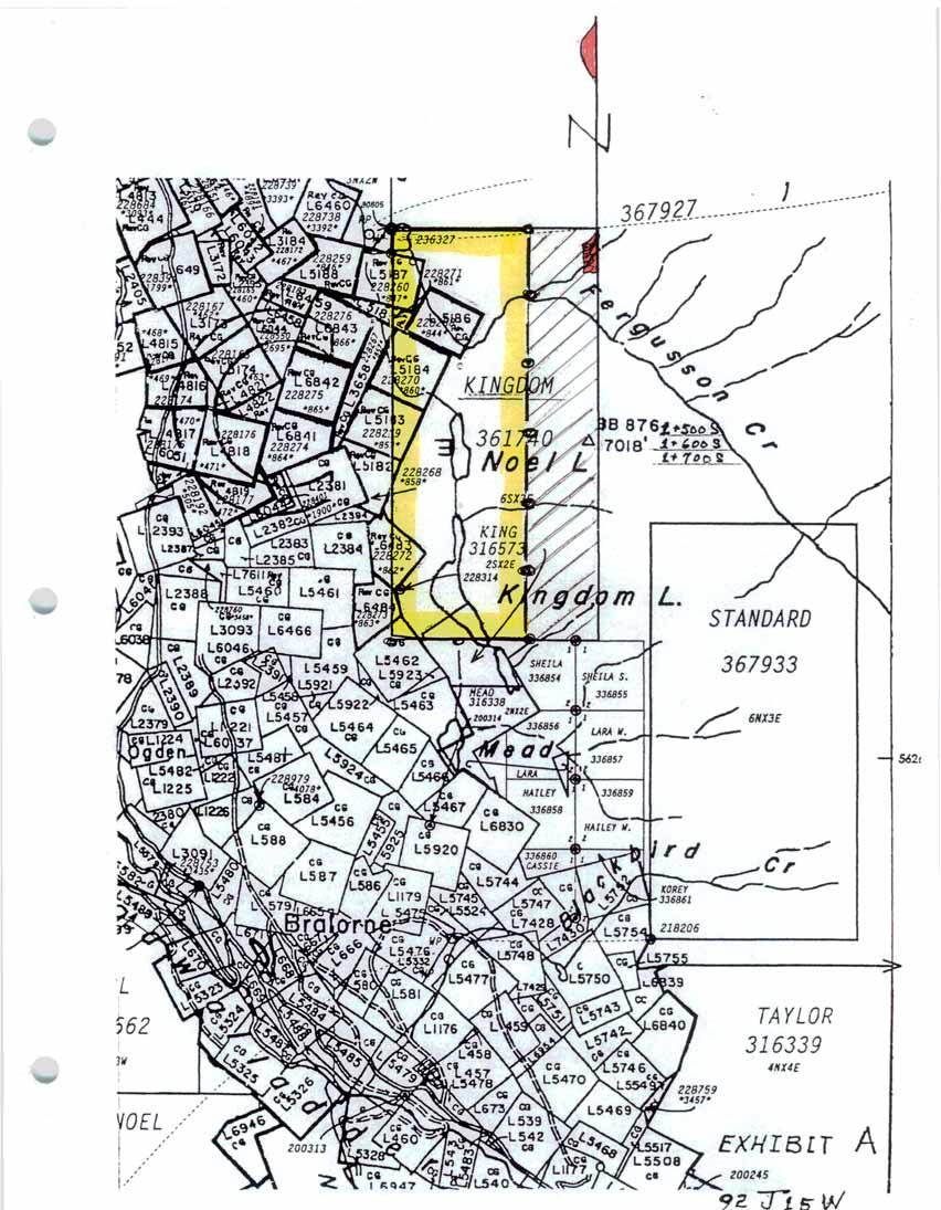
1 PHYSICAL WORK REPORT ON THE KINGDOMlwINERAL CLAIM LILLOOET MINING DIVISION NTS Map Sheet 92J/15W Co-Ordinates North: East For Assessment Work BY Edward Skoda October 15,2002 Vancouver, British Columbia
2 TABLE OF CONTENT Page Number Introduction Land Tenure Access and location Physiography Previous work Technical data and interpretation Recommendations 0 Itemized cost statement Statement of qualifications Maps: Mineral claim map Grid layout Assays: Chemex Labs Exhibit A Exhibit B Exhibit C 0
3 0 INTRODUCTION REPORT ON THE KINGDOM MINERAL CLAIM The KINGDOM mineral claim was laid out and staked to encompass the Kingdom Lake, Noel Lake and Lost Lake waterway system. The objective of this annual physical program is to commence soil sampling along the baseline and two grid lines. A total budget of $ was expensed on this project. LAND TENURE The KINGDOM mineral claim was located and staked by Mr. Ed Skoda on March 17, 1999 and is presently in good standing. The claim block was originally staked as 18 units, but has now been reduced to 12 units totaling 300 hectares. ACCESS AND LOCATION t, The legal corner post (LCP) is located on the north shore of Lost Lake. The Lost Lake access road, which is a spur of the Kingdom Lake logging road, which in turn junctions five kilometers south of Gold Bridge on the Bralome access road. The Kingdom Lake logging road is not active in the winter. Access to the three grids is by snowmobile during the winter months and vehicle during the summer months. PHYSIOGRAPHY The topography on the eastern claim boundary is extreme. The remaining claim area is rolling topography with a system of lakes trending northward through the claim. Grid elevation is approximately 1,250 meter location. The southwest segment of the claim block is second growth timber and the balance of the KINGDOM claim block is covered by a lake system and a moderate growth of pine. The climate is typified by hot, dry summers and cold snowy winters. PREVIOUS WORK In February 2000, SJV Geophysics conducted a two line Induced Polarization survey over a segment of the Kingdom Lake. This geophysical work was not filed in time for assessment credit. The results of this limited survey confirmed a fault structure, trending northward, on the west shore of the Kingdom Lake.
4 Old trenches were located near a gossan on the west shore of Noel Lake. A small temporary localized grid was established. Soil samples were collected and assayed for gold content using the AU-ICP21 assay procedure. TECHNICAL DATA AND INTERPRETATIONS The KINGDOM claim is underlain by the Fergusson Group Rock unit which consists of Paleozoic ribbon cherts and fine grained amphibolites. Forty geochemical soil samples were collected on the permanent grid system. All of these samples tested the B horizon located about 60 cm to 100 cm below the surface ash layer. Twenty-five geochemical soil samples were collected on the baseline between 1+5OOS to 2+5OOS, at sample stations 20 meters apart. Fifteen geochemical soil samples were collected on two grid lines, s and on 20 meter stations. Only fifteen grid line soil samples were submitted to ASL Chemex for assaying using the Au-ICP21 procedure. The balance of the soil samples will be submitted for geochemical analysis with the proposed 2003 field sampling program. RECOMMENDATIONS The complete grid should be soil sampled and assayed for gold content, using the standard AU-ICP2 1 assay procedure, before the results are interpreted.
5 . ITEMIZED COST STATEMENT October 1.5,2002 Kingdom Mineral Claim Bralome Gold Camp British Columbia 1. Fees for service 6 days at $ per day $ 1,800.OO 2. Accommodation 4 days c, Board Transportation (AVIS) Field supplies ,ll Assays: Chemex Labs TOTAL COST $
6 STATEMENT OF QUALIFICATIONS I, Edward F. Skoda, do hereby certify that: 1. I am a contract Mine Technologist with a business address at: 2. My qualification are: Melville Street Vancouver, British Columbia V6E 4A6 l BCIT, Bumaby Campus, l 2 year Diploma in Business Administration 0 School of Mines, Haileybury, Ontario, year Diploma in Mining Technology l Free Miners Certificate No l Placer and Gravel Supervision No l Underground Shift Boss No I have been active in my mining career throughout Canada, USA, Ireland, Australia and New Zealand since I conducted the soil sampling program on the KINGDOM mineral claim for the physical work program from October 4 to October 9,2002. iy dward Skoda October 15,2002
7
8
9 A EXCELLENCE Al-5 c ALS CRemex IN ANALYTICAL CHEMISTRY ALS Cnnada u* 212 Elrooksbank Avenue NorlhVancowerBCV7J 2C1 Canada Phone: Fax: T 9\ 1THEY. RICK LO MELVILLE ST. VANCOUVER BC V6E 4A6 CERTIFICATE OF ANALYSIS VA Total # of ;a -c 6 :: 2* ;A ; Date : 13-Mar-2003 Account: HETRIC t,w,hd WEI-2, AWICP2, PIna,yte Recvdwt b it* kg wm Sample Description LOR , STNl+500S-O+ZOE STNltSOOS-O+JOE STN1+500S-O+SOE STNl+ 500S-O+BOE STN1+500S-O+lOOE STN1+500S-O+lZOE STNi+SOOS E STN,+500S-0+160E STNi+!?OOS-O+lEOE STN It 500s E STNl+ SOOS E STN 1 + SOOS-0 l 240 E 0.32 co.001 STNZ+SOOS-O+ZOE STN2+500S-0+40E STN s.0+60 E
10 AlS Chemex EXCELLENCE IN ANALYTICAL CHEMISTRY AL5 Canada Lid 212 Brooksbank Avenue Nor,h anco er BC V7J 2Cl c Phone: Fax: c ;ETHEY. RICK MELVILLE ST. VANCOUVER BC V6E 4A6 c,age#: 1 Date : 13-Mar-2003 Account: HETRIC Project : P.O. No: CERTIFICATE VA This report is for 15 SOIL samples submitted to our lab in North Vancouver, EC. Canada on 5-Mar The following have access to data associated with this certificate: RICHARD HETHEY SAMPLE PREPARATION 1 ALS CODE DESCRIPTION WEI- Received Sample Weight LOG-22 Sample login Red w/o Barcode SCR-41 Screen lo -180um and save both ANALYTICAL PROCEDURES ALS CODE DESCRIPTION INSTRUMENT Au-ICPPl Au 309 FA ICP-AES Finish ICP-AES To: HETHEY, RICK ATTN: RICHARD HETHEY MELVILLE ST. VANCOUVER BC V6E 4A6 This is the Final Report and supersedes any preliminary report with this certificate number. Results apply tosamples as submitted. All pages of this report have been checked and approved for release. Signature: ;:+&C&-?;+.=>F ~ 7 &===- ---
Prospecting Report Grandpa Claim Group
 2010 2011 Prospecting Report Grandpa Claim Group TENURE NUMBER: 705523 EVENT NUMBER: 4825383 TENURE NAME: GRANDPA Lillooet Mining Division Map 092I Central Coordinate Reference 50 57 30 N Latitude 121
PHYSICAL WORK REPORT. the BAY CLAIMS. Omineca Mining Division Smithers, British Columbia N.T.S. 93E 13E/W
 PHYSICAL WORK REPORT the BAY CLAIMS Omineca Mining Division Smithers, British Columbia a N.T.S. 93E 13E/W LATITUDE: 53 57 00 N I LONGITUDE: 127 45 OO W for Home Ventures Ltd. 1201-675 West Hastings Street
ASSESSMENT REPORT ON THE PEAVINE PROJECT. DGW & Associates # Alberni Street, Vancouver, British Columbia, V6E 4V2
 ASSESSMENT REPORT ON THE PEAVINE PROJECT KAMLOOPS MINING DIVISION BRITISH COLUMBIA NTS 082M 12 Latitude 51 36' 19.0"North -- Longitude --119 47' 27.0"West UTM Zone 11, NAD 83 5720827N 306744E Prepared
We are committed to providing accessible customer service. If you need accessible formats or communications supports, please contact us.
 We are committed to providing accessible customer service. If you need accessible formats or communications supports, please contact us. Nous tenons à améliorer l accessibilité des services à la clientèle.
58 l'gr'n 'E. Date: January 23, 1979 ASSESSMENT REPORT PLACER SAMPLING & JADE BOULDER EVALUATION PLACER LEASE Liard Mining Divison 1041/7E
 ASSESSMENT REPORT PLACER SAMPLING & JADE BOULDER EVALUATION PLACER LEASE 1711 Liard Mining Divison 1041/7E 58 l'gr'n 18 38'E Owner & operator: Cry Lake Jade Mines Ltd. Author: A.M. Homenuke, P.Eng. Date:
GEOLOGICAL BRANCH ASSESSMENT REPORT 12. FItE NO: ACTION: THE GOLDEN MINING DIVISION, GOLDEN, Including THE NTS MAP; M82K/15W
 ACTION: FItE NO: Including 1990 GEO-CHEM SURVEY RESULTS -- THE AVD CLAIMS - THE GOLDEN MINING DIVISION, GOLDEN, B.C. NTS MAP; M82K/15W Lat. 50 deg. 55 Min. Long 116 deg. 55 min. For GEOLOGICAL BRANCH ASSESSMENT
SOIL GEOCHEMISTRY. OK-ll AND OK-Ill MINERAL CLAIMS MOUNT THOEN AREA OMINECA MINING DIVISION, B.C. NTS 93 MI6 E & 7 W
 SOIL GEOCHEMISTRY OK-ll AND OK-Ill MINERAL CLAIMS MOUNT THOEN AREA OMINECA MINING DIVISION, B.C. NTS 93 MI6 E & 7 W LATITUDE 55O23'N, LONGITUDE 127 01W Locke B. Goldsmith, P.Eng. Consulting Geologist December
PROSPECTING REPORT THE WALLACE CLAIM OMENICA MINING DIVISION. 54" x6" 3.d d. for. Reako Exlorat ions Ltd. Wallace Rev. C.G.
 PROSPECTING REPORT ON THE WALLACE CLAIM OMENICA MINING DIVISION 54"44 14 1x6" 3.d d by David A. Howard P.Eng. for Reako Exlorat ions Ltd. Claim Locat ion Wallace Rev. C.G. #1560 Dome Mountain Area 9 3
NTS 93L/9W GEOCHEMICAL AND GEOPHYSICAL REPORT MONA CLAIM OMINICA MINING DIVISION. Lati tude 54036'N; Longitude 'W
 GEOCHEMICAL AND GEOPHYSICAL REPORT ON MONA CLAIM OMINICA MINING DIVISION Lati tude 54036'N; Longitude 126018'W NTS 93L/9W April 1981 Paul Plicka Consulting Geologist LOCATION MAP INTRODUCTION TABLE OF
We are committed to providing accessible customer service. If you need accessible formats or communications supports, please contact us.
 We are committed to providing accessible customer service. If you need accessible formats or communications supports, please contact us. Nous tenons à améliorer l accessibilité des services à la clientèle.
on the Diamond Drilling done on the LAKESIOE GROUP of Mineral Claims SLOCAN MINING DIVISION 82-F-14-W Long ' Lat '
 Assessment Work Report on the Diamond Drilling done on the LAKESIOE GROUP of Mineral Claims SLOCAN MINING DIVISION 82-F-14-W Long 117 22' Lat. 49 58' ADRIAN KESLER SILVERTON, B.C. operator LEVON RESOURCES
REPORT OF PHYSICAL EXPLORATION AND DEVELOPMENT Section 15 - Mineral Tenure Act Regulation
 1. EVENT NUMBER(S) 1234567 4. RECORDED HOLDER Doe 123 Main Street REPORT OF PHYSICAL EXPLORATION AND DEVELOPMENT Section 15 - Mineral Tenure Act Regulation Mineral Titles and Policy Branch Ministry of
BALFOUR MINING LTD. (N.P.L.) HAM GROUP 92-P-6, CLINTON M. D.8 B. C. Lat 51 17'N, GEOCHEMICAL REPORT. V. CUKOR, P. Eng.
 HAM GROUP 92-P-6, CLINTON M. D.8 B. C. Lat 51 17'N, GEOCHEMICAL REPORT. V. CUKOR, P. Eng.") 34q '7 BALFOUR MINING LTD. (N.P.L.) HAM GROUP 92-P-6, CLINTON M. D.8 B. C. Lat 51 17'N, Long 12lo14'W GEOCHEMICAL REPORT, V. CUKOR, P. Eng. January 31, 1972 TABLE OF CONTENTS 1. INTRODUCTION 2. PROPERTY,
34q '7 BALFOUR MINING LTD. (N.P.L.) HAM GROUP 92-P-6, CLINTON M. D.8 B. C. Lat 51 17'N, Long 12lo14'W GEOCHEMICAL REPORT, V. CUKOR, P. Eng. January 31, 1972 TABLE OF CONTENTS 1. INTRODUCTION 2. PROPERTY,
GEOLOGICAL MAPPING REPORT ON THE ASH MINERAL CLAIM OSOYOOS MINING DIVISION ASHNOLA RIVER MAP SHEET NTS M092,H019 MCBRIDE CREEK AREA, ASHNOLA RIVER,
 GEOLOGICAL MAPPING REPORT ON THE ASH MINERAL CLAIM OSOYOOS MINING DIVISION ASHNOLA RIVER MAP SHEET NTS M092,H019 LATITUDE 49 o O6, LONGITUDE 120 o 22 MCBRIDE CREEK AREA, ASHNOLA RIVER, KEREMEOS, B.C. CANADA
Assessment Work Report. on the Geophysical Surveys carried out over the
 Assessment Work Report on the Geophysical Surveys carried out over the PINE GROUP of Mineral Claims 951-J-15-W Lillooet Mining Division Goldbridge, B.C. Long 122 48' Lat. 50 48' by Levon Resources Ltd.
Prospecting Report 'S Office i DB Property, B.C. -J Negro Creek Nelson Mining District NTS 82F.050. Operator: Kootenay Gold Inc.
 . '.' I"' i9 12 Prospecting Report 'S Office i DB Property, B.C. -J Negro Creek Nelson Mining District NTS 82F.050 Operator: Kootenay Gold Inc. Owner: Darlene Lavoie Work Performed Summer of 2007 Report
PROSPECTORS ASSISTANCE PROGRAM MINISTRY OF ENERGY AND MINES
 BRITISH COLUMBIA PROSPECTORS ASSISTANCE PROGRAM MINISTRY OF ENERGY AND MINES GEOLOGICAL SURVEY BRANCH PROGRAM YEAR: 1999/2000 REPORT #: PAP 99-l 6 NAME: KIM ANSCHETZ PROSPECTORS TlEPORT on the 99 LOUIS
1 FILMED 1. FILE NO:!..rsrru -* -. GRAND TWO CLAIM
 FILE NO:!..rsrru -* -. GRAND TWO CLAIM REPORT ON 1993 ASSESSMENT WORK GRAND TWO CLAIM REC. NO. 301849 NELSON MINING DIVISION NTS MAP SHEET 82F6/W 49 25'51" NORTH 117 18'08" WEST 1 FILMED 1 AUTHOR: R. Jordan,
GOLDSTAR PROPERTY LUMBY, BC
 SUMMARY REPORT ON THE GOLDSTAR PROPERTY LUMBY, BC Vernon Mining District NTS 82L 7/W
ASSESSMENT REPORT ON THE VLF-EM SURVEY. Trail Creek Mining Division NTS: 82 F/4 W Longitude: 1 17' 49' 50" Latitude: 49O 03' 40"
 ASSESSMENT REPORT ON THE JERO 5 MINERAL CLAIM ROSSLAND, BRJTISH COLUMBIA VLF-EM SURVEY Trail Creek Mining Division NTS: 82 F/4 W Longitude: 1 17' 49' 50" Latitude: 49O 03' 40" Owner: Operator: Author:
1 CLAIMS GEOPHYSICAL REPORT ON BOYAL SITUATE NORTHEAST OF TILLICUM MOUNTAIN GOLD AREA BURTON - NAKUSP SIQCAEJ MINING DIVISION
 GEOPHYSICAL REPORT ON BOYAL 1 CLAIMS SITUATE NORTHEAST OF TILLICUM MOUNTAIN GOLD AREA BURTON - NAKUSP SIQCAEJ MINING DIVISION CONSULTING GEOLOGIST AUGUST 1983 VANCOUVER B *C INDEX INTRODUCTION ooa,.eoaaa.aaaoaaooaoa~ao~o
ASSESSMENT REPORT TITLE PAGE AND SUMMARY
 ASSESSMENT REPORT TITLE PAGE AND SUMMARY TITLE OF REPORT: Assessment Report on Andys Bridge Mineral Claim, Turnagain River Area TOTAL COST: $2,100 AUTHOR(S): Bruce w Downing SIGNATURE(S): Bruce W Downing
REPORT ON MAGNETOMETER SURVEY TIK-1 CLAIM e&f KAMLOOPS MINING DTVISION. by D. Hendry D. C. MILLER. February 3, for
 REPORT ON MAGNETOMETER SURVEY TIK-1 CLAIM 92-1-14 e&f KAMLOOPS MINING DTVISION lat. 50 57 ' 12" long. 121O23 ' 37" OWNER: ST. JOSEPH EXPLORATIONS LIMITED OPERATIOR: ST. JOSEPH EXPLORATIONS LIMITED by D.
'-7' REPORT ON A MAGNETOMETER SURVEY OVER PART OF THE MAX CLAIM GROUP 1-20 LAC LE JEUNE AREA KAMLOOPS MINING DIVISION KAMLOOPS, BRITISH COLUMBIA
 I,., - SUITE 102. 222 BELLEVUE WES t ANCOUVER, B. '-7' REPORT ON A I MAGNETOMETER SURVEY OVER PART OF THE MAX CLAIM GROUP 1-20 LAC LE JEUNE AREA KAMLOOPS MINING DIVISION KAMLOOPS, BRITISH COLUMBIA 50-30
2013 GEOLOGICAL ASSESSMENT REPORT SHERIDAN HILL PROPERTY
 2013 GEOLOGICAL ASSESSMENT REPORT ON THE SHERIDAN HILL PROPERTY NEW WESTMINSTER MINING DIVISION BRITISH COLUMBIA NTS 092G07 49 16 31 NORTH LATITUDE, 122 39 48 WEST LONGITUDE PREPARED FOR Sheridan Hill
ASSESSMENT REPORT TITLE PAGE AND SUMMARY
 ASSESSMENT REPORT TITLE PAGE AND SUMMARY TITLE OF REPORT: 2016 Prospecting Report Midas Claim TOTAL COST: $314.61 AUTHOR(S): Giacomo Grassi SIGNATURE(S): NOTICE OF WORK PERMIT NUMBER(S)/DATE(S): STATEMENT
WORK REPORT. on the ALEXO PROPERTY DUNDONALD TOWNSHIP PORCUPINE MINING DIVISION. for LIBERTY MINES INC.
 GEOSCIE CE AS r::;ss lent OFFICE WORK REPORT on the ALEXO PROPERTY DUNDONALD TOWNSHIP PORCUPINE MINING DIVISION for LIBERTY MINES INC. 2. 340 51 Submitted by: Steve Anderson VISION EXPLORATION 2041663
ASSESSMENT' REPORT GEOPHYSICAL REPORT ON THE ATTORNEY 2 CLAIM (4 UNITS) OMINECA MINING DIVISION SHEILA A. CRAWFORD.
 OMINECA MINING DIVISION SHEILA A. CRAWFORD.") ASSESSMENT' REPORT GEOPHYSICAL REPORT ON THE ATTORNEY 2 CLAIM (4 UNITS) OMINECA MINING DIVISION by SHEILA A. CRAWFORD LOCATION: 57z17' N Latitude 127 11' W Longitude N.T.S. 94E/6E OWNER/OPERATOR: SEREM
ASSESSMENT' REPORT GEOPHYSICAL REPORT ON THE ATTORNEY 2 CLAIM (4 UNITS) OMINECA MINING DIVISION by SHEILA A. CRAWFORD LOCATION: 57z17' N Latitude 127 11' W Longitude N.T.S. 94E/6E OWNER/OPERATOR: SEREM
DEVELOPMENT REPORT. Lone I Mineral Claim Group. Wild Horse River Area Cranbrook, B.C.
 DEVELOPMENT REPORT Lone I Mineral Claim Group Wild Horse River Area Cranbrook, B.C. Fort Steele Mining District NTS 82G/12E 49 38 35 Latitude 115 38 00 Longitude LONE PEAK PLACER LTD. 514-13th Avenue South
7 MILES WEST OF PORT HARDY, B.C.
 GEOPHYSICAL REPORT VERTICAL INTENSITY MAGNETOMEER SURVEY ON LUK CLAIMS, 7 MILES WEST OF PORT HARDY, B.C. 50' 127O SE BY R. E. SHIELDS UNDER SUPERVISION OF J. R. BILLINGSLEY FOR SECOND0 MINING LTD. (N.
..!I AXE CLAIMS ON THE. for RICHCORE EXPLORATIONS LTO. GREENWOOD MINING DIVISION BRITISH COLUMBIA. Latitude 49O 30"; Longitude 118' 30'W NTS 82E/9W
 ON THE AXE CLAIMS for RICHCORE EXPLORATIONS LTO. GREENWOOD MINING DIVISION BRITISH COLUMBIA Latitude 49O 30"; Longitude 118' 30'W NTS 82E/9W... -... ~ i.,...._.'..!i Vancouver, B.C. September, 1980 P.
SUPPLEMENT TO MAGNETOMETER 6 ELECTROMAGNETIC SURVEY REPORT. DATED NOVEMBER l, 1973 CIGLEN INVESTMENTS LIMITED CLAIMS GROUP BAD VERMILLION LAKE AREA
 ^ A R l ^ 1974 010 PROJECTS UNIT SUPPLEMENT TO MAGNETOMETER 6 ELECTROMAGNETIC SURVEY REPORT DATED NOVEMBER l, 1973 CIGLEN INVESTMENTS LIMITED CLAIMS GROUP BAD VERMILLION LAKE AREA DISTRICT OF RAINY RIVER
SOIL GEOCHEMISTRY ENTERPRISE MINE NTS 82 F/14 W ARCTEX ENGINEERING SERVICES CONSULTANT, OWNER, OPERATOR, AUTHOR JANUARY, 1.981
 SOIL GEOCHEMISTRY ENTERPRISE MINE t SLOCAN MINING DIVISION, Bn C, NTS 82 F/14 W LATITUDE 49'49') LONGITUDE 1'19' ARCTEX ENGINEERING SERVICES I L, B, GOLDSMITH, PiENG, CONSULTANT, OWNER, OPERATOR, AUTHOR
GRANGES EXPLORATION AB CANADIAN DIVISION
 GRANGES EXPLORATON AB CANADAN DVSON GEOCHEMCAL REPORT ON "B" and "D" CLAMS OMNECA MNNG DEVSON FAWNE NOSE AREA LATTUDE: 53O 19' LONGTUDE: 125O 1' MNERAL RESOURCES BRANCH N.T.S 93F/6 E Owner and Operator
CONSULTING GEOLOGICAL 8: MINING ENGINEERS STINGS STREET DA V6E 2E9 GEOPHYSICAL SURVEY SILVER QUEEN 2 ZEBALLOS AREA. B.C.
 DOLMAGE CAMPBELL & ASSOCIATES (1 975) LTD. CONSULTING GEOLOGICAL 8: MINING ENGINEERS STINGS STREET DA V6E 2E9 '' 1E O L 0 G I C A.L B'x;&a:f2:#& 'SESSMENT REPObT 12, Assessment RESOURCES LTD. 111 ReDort
GEOPHYSICAL REPORT CHU CHUA PROJECT Green Mountain Group. KAMLOOPS MINING DIVISION NTS 92P/8E, 82M/5W Lat: 51'24' N Long: 120'00' w
 I GEOPHYSICAL REPORT CHU CHUA PROJECT Green Mountain Group KAMLOOPS MINING DIVISION NTS 92P/8E, 82M/5W Lat: 51'24' N Long: 120'00' w I rvm #.,_..._..._._._.- $...-...! 1 VANCOUVER, B.C. 1 G E 0 I, 0.G
We are committed to providing accessible customer service. If you need accessible formats or communications supports, please contact us.
 We are committed to providing accessible customer service. If you need accessible formats or communications supports, please contact us. Nous tenons à améliorer l accessibilité des services à la clientèle.
PHOENIX GEOPHYSICS LIMITED REPORT ON THE VLF-EM AND TOTAL FIELD MAGNETOMETER SURVEYS ON THE
 PHOENIX GEOPHYSICS LIMITED REPORT ON THE VLF-EM AND TOTAL FIELD MAGNETOMETER SURVEYS ON THE TAN CLAIMS, CHILLIWACK AREA NEW WESTMINSTER MINING DIVISION, BRITISH COLUMBIA FOR LORNEX MINING CORPORATION LIMITED
ASSESSMENT REPORT TITLE PAGE AND SUMMARY
 ASSESSMENT REPORT TITLE PAGE AND SUMMARY TITLE OF REPORT: 2016 Prospecting Report Sphynx Claim TOTAL COST: $167.56 AUTHOR(S): Giacomo Grassi SIGNATURE(S): NOTICE OF WORK PERMIT NUMBER(S)/DATE(S): STATEMENT
STONE MOUNTAIN. Owner: Kimberly Gale Powell. Technical Report for Tenures: , , , , ,
 STONE MOUNTAIN Owner: Kimberly Gale Powell Technical Report for Tenures: 415067, 415068, 415069, 415070, 415071, 415072. Approximate Property Location Latitude 49 29 3 North Longitude: 120 40 47 West Similkameen
PRECIOUS METALS. owner. JMT Services Corp. GEOCHPlICAL SAMPLING CHELASLIE WCE, NORTH CENTRAL, B.C. OMINECA MINING DIVISION NTS 93F/5E & 6W
 PRECIOUS METALS REPORT ON 1980 RECONNAISSANCE GEOCHPlICAL SAMPLING CHELASLIE WCE, NORTH CENTRAL, B.C. OMINECA MINING DIVISION NTS 93F/5E & 6W LATITUDE 53O28 N LONGITUDE 125O31 W DATES Qp WORK: JULY 10
SOIL GEOCHEMISTRY TUFA MINERAL CLAIM SLOCAN MINING DIVISION ZINCTON, B.C. NTS 82K 3E LATITUDE 50"02'20"N, LONGITUDE 117'11'W
 SOIL GEOCHEMISTRY TUFA MINERAL CLAIM SLOCAN MINING DIVISION ZINCTON, B.C. NTS 82K 3E LATITUDE 50"02'20"N, LONGITUDE 117'11'W LOCKE B. GOLDSMITH, P.ENG., P.GE0. CONSlULTING GEOLOGIST OCTOBER 30,2001 TABLE
49" 3-4 I4 I \ Y 59 tj
 ASSESSMENT REPORT Mary 4 FORT STEELE M.D. NTS 82G/5W 49" 3-4 4 \ Y 59 tj Owner: St. Eugene Mining Corporation Limited Operator : St. Eugene Mining Corporation Limited Author: John R. Wilson Date Submitted:
RECONNAISSANCE GEOCHEMICAL SURVEY
 RECONNAISSANCE GEOCHEMICAL SURVEY LEGAL, RITA, LOUISE FR. (CHAPLEAU GROUP) REVERTED CROWN GRANTS CHAPLEAU CREEK AREAJ, SLOC& MINING DIVISION 82 F/11W Lat: 49'44" Long: 117"22'W MINERAL RESOURCES BRANCH
GEOLOGICAL BRAN ASSESS
 TITLE PAGE This report covers assessment work performed on the Mundy group, located in the Boundary Creek area, north of Greenwood, British Columbia. The work comprises of THM soil testing, trenching and
EXPLORATION and DEVELOPMENT REPORT. Conrad Creek. PLACER and MINERAL CLAIMS SOUTHEAST BRITISH COLUMBIA
 EXPLORATION and DEVELOPMENT REPORT on Conrad Creek PLACER and MINERAL CLAIMS in SOUTHEAST BRITISH COLUMBIA Ed Friesen, BSc.E.E., P. Eng 8 Lake Placid Rise SE Calgary, Alberta T2J 5B5 April 2009 1 P age
Daiwan Engineering Ltd Granville strees V.ncouver, B. C. cuudr WY 1GS. M e : (604) PROSPECTING REPORT ON THE KING MINERAL CLAIMS
 PROSPECTING REPORT ON THE KING MINERAL CLAIMS") 1030-609 Granville strees V.ncouver, B. C. cuudr WY 1GS M e : (604) 688-1508 PROSPECTING REPORT ON THE KING MINERAL CLAIMS NORTH VANCOUVER ISLAND, BRITISH COLUMBIA NTS: 92Lj13E Latitude: 50" 47' Longitude:
1030-609 Granville strees V.ncouver, B. C. cuudr WY 1GS M e : (604) 688-1508 PROSPECTING REPORT ON THE KING MINERAL CLAIMS NORTH VANCOUVER ISLAND, BRITISH COLUMBIA NTS: 92Lj13E Latitude: 50" 47' Longitude:
UNION MINIERE EXPLORATIONS AND MINING CORPORATION LIMITED ASSESSMENT REPORT ON FITINAT MINERAL CLAIM. Alberni Mining Division Record No.
 M F )( UNION MINIERE EXPLORATIONS AND MINING CORPORATION LIMITED Suite 200, 4299 Canada Way, Burnaby, B.C. V5G 1 H4 Telephone (604) 437-9491 ASSESSMENT REPORT ON GEOCHEMICAL SOIL SURVEYS AND ROCKSAMPLING
Lat. 52' 43' N Long ' W
 &A exploration ltd MINING ENGINEERING GEOLOGY- GEOPHYSICS 4570 HOSKINS ROAD, NORTH VANCOUVER, 6. C. TELEPHONE (804) 985,7921 V7K 2R1 GEOLOGICAL AND GEOCHEMICAL REPORT on the BLUE CLAIMS Cariboo Mining
Report of Gridding and Magnetic Surveys. On the. Munro Property. Munro and Beatty Townships, Ontario. Larder Lake Mining Division
 Report of Gridding and Magnetic Surveys On the Munro Property Munro and Beatty Townships, Ontario Larder Lake Mining Division Claims: 39 4244 For Big Red Diamond Corporation October 3, 2 Timmins, Ontario
compietea since tnat date, and wnicn comprisea btage I ot tne recommended
 compietea since tnat date, and wnicn comprisea btage I ot tne recommended four-stage program. GEOLOGY & MINERALIZATION The property situate6 on the southeast slope of Nickel Plate Mtn., and within the
ASSESSMENT REPORT MAGNETOMETER SURVEY GOLDEN ROD, GOLDEN ROD #2. Long.: General Delivery, Vananda, B. C.
 ASSESSMENT REPORT MAGNETOMETER SURVEY GOLDEN ROD, GOLDEN ROD #2 t=/ NTS 92~110w Lat.: Long.: 49O 44' N 124O 34' W Owner: E. Johanson General Delivery, Vananda, B. C. Operator: Rhyolite Resources I nc.
t+o...&zz!. ASSESSMENT REPORT Department of Miner and Petroleum Resources MAP.,- INDUCED POLAKIZATION SURVEY OVER THE BROOKS PROSPECT
 5873 INDUCED POLAKIZATION SURVEY OVER THE BROOKS PROSPECT BROOKS PENINSULA AREA VANCOUVER ISLAND, B.C. NANAIMO AND ALBERNI MINING DIVISIONS BY Z. B. DOBORZYNSKI JANUARY, 1976 Department of Miner and Petroleum
Serengeti Resources Inc GEOCHEMICAL REPORT ON THE SHADOW PROPERTY a.
 Serengeti Resources Inc. 2004 GEOCHEMICAL REPORT ON THE SHADOW PROPERTY a. Located in the Johanson Lake Area Omenica Mining Division NTS 94D/9 6 degrees and 32 minutes North Latitude 126 degrees and 2
J.D. Mason, Prof. Engineer. Report on the Reconnaissance Magnetometer Survey. Completed for. North American Platinum Corporation Ltd.
 Report on the Reconnaissance Magnetometer Survey Completed for North American Platinum Corporation Ltd. Olivine Mountain Property, Tulameen, B.C. J.D. Mason, Prof. Engineer. November 28, 1967. Certificate
-KERR-ADDISON GOLD MINES LTD. 6EOPHYSICAL & GEOCHEMICAL INVESTIGATION. Of 24 CLAIMS Of THE FAULT GROUP OF MINERAL CLAIMS
 -KERR-ADDISON GOLD MINES LTD. 6EOPHYSICAL & GEOCHEMICAL INVESTIGATION Of 24 CLAIMS Of THE FAULT GROUP OF MINERAL CLAIMS Located About 3 Miles West Of Merritt, B.C. In Nicola M.D. 50 N - 120 w BY W. M.
We are committed to providing accessible customer service. If you need accessible formats or communications supports, please contact us.
 We are committed to providing accessible customer service. If you need accessible formats or communications supports, please contact us. Nous tenons à améliorer l accessibilité des services à la clientèle.
Cominco ltd. REPORT OF GRID "C" GEOCHEMICAL SURVEY ON VINE 1 CLAIM, VINE 1, 25, 27 CLAIM GROUP Fort Steele Mining Division
 GOVERNMENT OFFICE Cominco ltd. EXPLORATION DIVISION REPORT OF GRID "C" GEOCHEMICAL SURVEY ON VINE 1 CLAIM, VINE 1, 25, 27 CLAIM GROUP Fort Steele Mining Division Submitted by: E.W. BATCHELOR Cominco Ltd.
DiaMine Exploration Inc. Pickle Lake Option Property
 DiaMine Exploration Inc. Pickle Lake Option Property Rock Sampling Program and Field Observations Claims 4249174, 4249175, 4249176 and 4249177, Kapkichi Lake Area (G-2081) And Claims 4249178, 4249179 and
MtNERAL EXPLORATION CONSULTANTS ASSESSMENT REPORT MT. MILLIGAN AREA OMINECA M.D. Latitude: 55' 07' N Longitude: 123" 56' W NTS : 93 0/4 W.
 D. L. COOKE AND ASSOCIATES LTD. MtNERAL EXPLORATION CONSULTANTS ASSESSMENT REPORT 1989 PRELIMINARY GEOCHEMICAL SURVEY KC MINERAL CLAIMS MT. MILLIGAN AREA OMINECA M.D. Latitude: 55' 07' N Longitude: 123"
GEOCSZNICAL - SURVEY. ICAMLOOPS Kl.D. 2'' 6;kr. HY "'f. Alfred R. Allen,P.Eng. 1 NO.%=...,... 6"- 'I.
 t i.i GEOCSZNICAL - SURVEY i p' ICAMLOOPS Kl.D. 2'' 6;kr HY 50-64 +."'f 121-51 NE 5-10-70 : 19-10-70 Alfred R. Allen,P.Eng. I) ' 1 6"- 'I. 1 NO.%=...,..... Q.C. EXPLORATIONS LTD. 2Cl- 535 Kowe Street Vancouver
Northern Dynasty Minerals Ltd.
 Northern Dynasty Minerals Ltd. 1020 800 W Pender St. Vancouver BC Canada V6C 2V6 Tel 604 684-6365 Fax 604 684-8092 Toll Free 1 800 667-2114 http://www.northerndynasty.com RESOURCE ESTIMATE FOR PEBBLE EAST
VLF and GRADIOMETER SURVEY OVER THE CAT GROUP, INVERMERE AREA GOLDEN MINING DIVISION, BRITISH COLUMBIA NTS 82K/O8W LAT/LONG 50 29' ' FOR
 VLF and GRADIOMETER SURVEY OVER THE CAT GROUP, INVERMERE AREA GOLDEN MINING DIVISION, BRITISH COLUMBIA NTS 82K/O8W LAT/LONG 50 29' - 116 15' FOR W. POCHYLKO STETTLER, ALBERTA BY T.R.B. DUNDAS ISOGEOS EXPLORATION
SELF POTENTIAL SURVEY OVER THE JAY GROUP, INVERMERE AREA GOLDEN MINING DIVISION, BFUTISH COLUMBIA NTS 82W8W7 82W9W LATLONG 50 30' ' FOR
 - GEOLOGICAL SURVEY BRANCH ASSESSMENT REPORTS -- -- DATE RECEI?/::D 06T 10 1996 - SELF POTENTIAL SURVEY OVER THE JAY GROUP, INVERMERE AREA GOLDEN MINING DIVISION, BFUTISH COLUMBIA NTS 82W8W7 82W9W LATLONG
REPORT ON A GEOLOGICAL MAPPING AND PROSPECTING PROGRAM LOOK PROPERTY
 b KOKANEE EXPLORATIONS LTDI I WNO. 0 I- n c/ REPORT ON A GEOLOGICAL MAPPING AND PROSPECTING PROGRAM LOOK PROPERTY LOOK 1-31, 36-43 CLAIMS FORT STEELE MINING DIVISION CRANBROOK AREA N.T.S. 82G/5W + 4E E:
PERCUSSION DRILLING REPORT ON THE MARA #1 CLAIM. Sirnilkameen Mining Division, B.C. for
 PERCUSSION DRILLING REPORT ON THE MARA #1 CLAIM Sirnilkameen Mining Division, B.C. for PARA MINERALS ti OILS INC. 770 McFarlane Tower, 700-4th Avenue S.W. Calgary, Alberta T2P 354 J.P. ELWELL, P. Eng.
MAWSON RESTARTS EXPLORATION DRILLING AT THE ROMPAS GOLD PROSPECT IN FINLAND
 1305 1090 West Georgia Street, Vancouver, BC, V6E 3V7 Phone: +1 604 685 9316 / Fax: +1 604 683 1585 NEWS RELEASE August 30, 2017 MAWSON RESTARTS EXPLORATION DRILLING AT THE ROMPAS GOLD PROSPECT IN FINLAND
EWS PETROLEUM CORPCWAT~ WEST HASTINGS STREET VANCOUVER, 8. C. V6C 186
 EWS PETROLEUM CORPCWAT~ 613-837 WEST HASTINGS STREET VANCOUVER, 8. C. V6C 186 GEOPHYSICAL REPORT on a VLF - ELECTROkAGNETlC SURVEY on the SHEBA MINERAL CLAIM CARIBOO MINING OIVISION NTS 93 H/3 Lat. 53
News Release No GOLD AND COPPER MINERALIZATION DISCOVERED DURING PHASE 2 EXPLORATION AT THE MCBRIDE PROPERTY
 November 19, 2018 TSX Venture Exchange Listed Frankfurt Exchange Listed News Release No. 303-2018 GOLD AND COPPER MINERALIZATION DISCOVERED DURING PHASE 2 EXPLORATION AT THE MCBRIDE PROPERTY Vancouver,
DRILLING REPORT ON THE HIGHLAND VALLEY, KAMLOOPS MINING DIVISION, OWNED BY GAZA MINES LTD., NEW JERICHO DEVELOPMENT AND TECK CORPORATION
 DRILLING REPORT ON THE GAZA 1 AND JERICHO 1 AND 2 MINERAL CLAIMS / (RECORD NUMBERS 159, 492 AND 161) HIGHLAND VALLEY, KAMLOOPS MINING DIVISION, LATITUDE 50' 26' N; LONGITUDE 120' 55' W; NTS 92-I/7W OWNED
4. Geological maps published by the Ontario Department of Mines.
 52J08NWei45 S2J08NWa6B1 SMYE 010 AMALGAMATED RARE EARTH MINES LTD. *, SAVANT LAKE PROSPECT x ONTARIO INTRODUCTION t This Is a report on a group of 28 claims control led by Amalgamated Rare Earth Mines
3 I1 I I Ill 111 II! II 111 II Ill I IlE I I P I
 -7 3 1 1 11111111111111111111111111111111 ll 111! 111 111 111 111 111111111111111 ll 1111111 1 11111111111111 le P GEOCHEMCAL SURVEY OF THE KE AND D'ARCY CLAM GROUPS.. Similkameen Mining Division, B.C.
Summary of Rover Metals Geologic Mapping Program at the Up Town Gold Project, Northwest Territories
 October 13, 2017 Summary of Rover Metals Geologic Mapping Program at the Up Town Gold Project, Northwest Territories Vancouver, British Columbia, Canada - Rover Metals Corp., Rover, is pleased to provide
Gold c 8 Rl!TI I8 8 I0 n0 '8 Off VANCOUVER, B.C. btandard I Property
 ,- PROSPECTING REPORT For the 1 Gold c 8 Rl!TI I8 8 I0 n0 '8 Off ig@ VANCOUVER, B.C. btandard I Property I SALMON GOVERNMENT AGENT ARM I Tenure Number 554772 Revelstoke Mining Division, B.C. BCGS GRID
LUCKY BEN MINE PROJECT SEPTEMBER 2018 UPDATE
 LUCKY BEN MINE PROJECT SEPTEMBER 2018 UPDATE During the first week of July 2018 work was completed by our Geologist, Richard Morris, and support personnel to stake the Lucky Ben vein structure at surface
NTS 082F03SW N W U E N
 Prospecting Report JOCELYN CLAIM NTS 082F03SW N49 09 51 W 117 14 04 11U 482906E 5445737N NELSON MINING DIVISION Martin Ross PO Box 323 Salmo BC V0G 1Z0 Jan 31, 2012 PROSPECTING REPORT JOCELYN MINERAL CLAIM
GEOPHYSICAL REPORT INDUCED POLARIZATION/RESISTMTY SURVEYS. on behalf of TEESHIN REOURCES LTD Argus Road. Oakville, Ontario L6J 354
 GEOPHYSICAL REPORT INDUCED POLARIZATION/RESISTMTY SURVEYS DOME MOUNTAIN PROPERTY, SMITHERS AREA CHRIS, APRIL 1, APRIL 2, APRIL 3, AND MAG 1 CLAIMS CMINECA MINING DMSION, BRITISH COLUMBIA Latitude: 546
PIOTR LUTYNSKI VANCOUVER, BRITISH COLUMBIA
 AN ASSESSMENT REPORT ON GROUND MAGNETIC SURVEYING CHUCHI PROPERTY FORT ST. JAMES AREA, BRITISH COLUMBIA OMINECA M.D. 55 17 N, 124 31 W NTS 93N/ 7&8 Claims Surveyed: 597976, 597878-597880 Survey Dates:
for the Greenwood Mining Division, B.C. NTS 82E/7W Latitude 49' 27' W, Longitude 118' 5 Prepared by a= D. Dylan Watt, B.Sc.
 t. b LOGnO: 37~ -08 m. ACTIO#: for the AMP AMP 2 AMP 3 t AMP 4 CLAIMS Greenwood Mining Division, B.C. NTS 82E/7W Latitude 49' 27' W, Longitude 8' 5 %E c,w zc *& a w Prepared by a= -4c. D. Dylan Watt, B.Sc.
TOPOGRAPHICAL SURVEY REPORT ON THE GREENDROP PROPERTY NEAR CHILLIWACK, B.C. 92-H-3/W
 TOPOGRAPHICAL SURVEY REPORT ON THE GREENDROP PROPERTY NEW WESTMINSTER M.D. NEAR CHILLIWACK, B.C. 92-H-3/W Location: The central pap of the claims is located at coordinates 49 08'N, latitude by 121 26'W,
Date Submitted: June General Nature of Report: Examination of Placer Samples
 General Nature of Report: Examination of Placer Samples Claim: Gold Channel, Record Number 3775!8 1 (Gold Channel Placer Property) Mining Division: Cariboo NTS 093 G 09 W and E Latitude 520 23 N' Longitude1210
PROSPECTING REPORT. Broken Hill Property. EVENT # TENURE # Tenure Name: Broken Hill. New Westminster Mining Division Map 092H
 2009-2010 PROSPECTING REPORT Broken Hill Property EVENT # 4514071 TENURE # 600988 Tenure Name: Broken Hill New Westminster Mining Division Map 092H Central Coordinate Reference 121 24 26.2 W Longitude
121 deg 44' W and 53 deg 07' N
 M.R. #. R... VANCOUVER, B.C. REPORT ON THE WILLOW AND WILLOW I CLAIMS RECORD NO. 8475 AND 8476 CARIBOO MINING DIVISION NTS 93 H/4 121 deg 44' W and 53 deg 07' N 'W OWNER AND OPERATOR: RUZA RESOURCES LTD.
October 8, 2015 News Release Brucejack Regional Drilling Intersects Over 8,000 Grams Per Tonne Gold
 October 8, 2015 News Release 15-24 Brucejack Regional Drilling Intersects Over 8,000 Grams Per Tonne Gold Vancouver, British Columbia October 8, 2015; Pretium Resources Inc. (TSX/NYSE:PVG) ( Pretivm or
COMINCO LTD. HORIZONTAL LOOP EM AND MAGNETIC SURVEYS ON SHA. CLAIMS 1, 2, 7 and 8 NELSON AND FORT STEELE MINING DIVISIONS, B.C.
 COMINCO LTD. EXPLORATION WESTERN DISTRICT NTS: 82-F/1 HORIZONTAL LOOP EM AND MAGNETIC SURVEYS ON SHA CLAIMS 1, 2, 7 and 8 - ASSESSMENT REPORT - NELSON AND FORT STEELE MINING DIVISIONS, B.C. Latitude Longitude
DIAMOND DRILL REPORT ON THE LOCATED IN THE OMINECA MINING DIVISION FAWNIE NOSE AREA LATITUDE: 53O 17' LONGITUDE: 125O 10' NTS 93F 6E
 GRANGES EXPLORATION AB CANADIAN DIVISION DIAMOND DRILL REPORT ON THE G, H and I CLAIM BLOCKS LOCATED IN THE OMINECA MINING DIVISION FAWNIE NOSE AREA LATITUDE: 53O 17' LONGITUDE: 125O 10' NTS 93F 6E. -.
Prospecting, Technical, & Geochemical Assessment Report
 i.l_ #516184 Prospecting, Technical, & Geochemical Assessment Report Tenures #411241 All The Marbles Project Le Baron Prospecting Port Renfrew BC Q! % 092C069 Report for Owners Scott Phillips Bob Morris
GEOLOGICAL BRANCH ASSESSMTNF REPORT
 A GEOCHEMICAL REPORT on the 49 CR. GROUP APPROX. 9 mi SW OF NELSON, B.C 49 CREEK AREA NELSON NINING DIVISION BRITISH COLUNBIA NINERAL CLAIM MAP N. T.S. 82-~/6 WEST LATITUDE$ 49' 27'~ LONGITUDE : 117' 2j0w
REPORT. on the. Omineca Mining Division, British Columbia. Latitude N., Longitude W. NTS map sheet 93F/7E. James W. McLeod, P.Geo.
 REPORT on the CHU MOLYBDENUM PROPERTY Omineca Mining Division, British Columbia Latitude 53 21 N., Longitude 124 37 W. NTS map sheet 93F/7E James W. McLeod, P.Geo. on behalf of Mr. Chris Delorme TABLE
ASSESShAENT REPORT Mines and Petroleum Resources. Department of. No* JIMMY MINERAL CLAIM FRANKLIN CREEK AREA, GREENWOOD M. D.
 GEOCHEMICAL REPORT ON JIMMY MINERAL CLAIM FRANKLIN CREEK AREA, GREENWOOD M. D. Lat. 49'35' OON, N.T.S. Long. 118O22' 00W 82-E-9 July 18-21, 1974 Vancouver, B.C. J.J. McDougall, P.Eng. July 21, 1974 * Department
Ronin Placer Ground-penetrating Radar Survey Report
 Ronin Placer Ground-penetrating Radar Survey Report Tenures: 837095, 837097 Mining Division: Greenwood NTS Location: 082E/03 Geographic Center Coordinates: UTM Zone 11, E 345340, N 5438730 Claims Owner:
April Exploring for Canadian Gold in the Rainy River District of Ontario
 April 2013 Exploring for Canadian Gold in the Rainy River District of Ontario 1 Forward Looking Statements This presentation may contain forward-looking statements including but not limited to comments
PROSPECTING REPORT. re. Minera.1 C laims
 PROSPECTING REPORT re. Minera.1 C laims P R 1 Record #3052 (6) P R 2 Record #3053 (6) p R 3 Record #3054 (6) at Ilong.129, Latt. 58 20' in the Two Mile Creek area of Turnagain River drainage system in
490 20' 30" North Latitude ' 30" West Longitude
 _._.. I CONSULTING GEOLOGISTS 605-602 WEST HASTINGS STREET, VANCOUVER, B.C. V6B 1P2 TELEPHONE: (604) 689-5533 6 I F: ASSESSMENT REPORT ON THE PATSY 1 MINERAL CLAIM ' '?%2% I WHISTLE CREEK, HEDLEY ARE L-l-
REPORT ON APPLICATION TO RECORD WORK. on the CLAIM GROUP. BY Owners. issued at Penticton, B.C. Jan 19,1976. issued at Rossland B.C. Jan.
 --.. REPORT ON APPLICATION TO RECORD WORK on the CLAIM GROUP 1976 2133 meters North-North-East Okanagan I- Falls Post Office 0,// --7 L Lat. 493 21 N., Long. 119 33 W
12Io - 25' West Longitude GEOLOGICAL ASSESSMENT REPORT ON THE AU 1 CLAIMS WEST NORSE RESOURCES LIMITED HOPE - YALE AREA
 GEOLOGCAL ASSESSMENT REPORT ON THE AU 1 CLAMS WEST NORSE RESOURCES LMTED HOPE - YALE AREA NEW WESTMNSTER MNNG DVSON R.E. Renshaw, P. Eng. Consulting Geologist 49O - 33' North Latitude 12o - 25' West Longitude
PROSPECTING REPORT TENURES # / / CLAIM NAMES OLD SETTLER; OLD SETTLER1; OLD SETTLER2
 2011 PROSPECTING REPORT EVENT - 5160426 TENURES # 688183 / 691903 / 691905 CLAIM NAMES OLD SETTLER; OLD SETTLER1; OLD SETTLER2 COAST CRYSTALINE BELT REGION NEW WESTMINSTER MINING DISTRICT MAP - 092H GPS
BRY PLACER GROUP. Assessment Report Gravel,silt sampling and panning on. Claims: , , Located on map sheet 093A 062
 BRY PLACER GROUP Assessment Report 2012 Gravel,silt sampling and panning on Claims: 523068, 522278, 589718 Located on map sheet 093A 062 5~2 57'3/A/ / 31 Hi' 9 " )Aj Cariboo D/viS''on Owner-operator Egil
Geochemical Assessment Report. on the. Situated Nineteen Kilometres rth-northeast of Hope, B. C. in the. New Westminster Mining Division
 7 I Geochemical Assessment Report r on the r- I 1 Norm 1 to Norm 4 Mineral Claims c - I - 7 Situated Nineteen Kilometres rth-northeast of Hope, B. C. in the New Westminster Mining Division itude 49*32'N.,
PERCY CONTRACTING SERVICES LTD.
 GEOLOGICAL REPORT ON TEN PLACER LEASES (3139, 3140, 3141, 3142, 3143, 3144, 3145, 3146, 3147, 3148) MOREHEAD CREEK CARIB00 MINING DIVISION, B.C. 938/12W (52 38 N, 121 47 W) For PERCY CONTRACTING SERVICES