RECONNAISSANCE GEOPHYSICAL SURVEY HELICOPTER - BORNE V. L.F. ELECTROMAGNETIC AND MAGNETIC GALLOWAY AREA FORT STEELE M.D., B.C.
|
|
|
- Valentine Potter
- 5 years ago
- Views:
Transcription
1 RECONNAISSANCE GEOPHYSICAL SURVEY HELICOPTER - BORNE V. L.F. ELECTROMAGNETIC AND MAGNETIC GALLOWAY AREA FORT STEELE M.D., B.C. Balsam 1-4 & 5-12 Cedar 1 & 2 Cedar South 1 & 2 Elderberry 1 Elderberry South 1 & 2 49'-151~ ~'~ N.T.S. 82~/6 & 11 Alfred R. Allen, P.Eng. August 18, 1983 u:.,- f a ' GEOLOGICAL BRANCH~~': R.H. stanfield f AS~ESSMENF REPORT st st.s.w. Calgary, Alberta By : Allen Geological Eng. Ltd Bellevue West Vancouver, B. C.
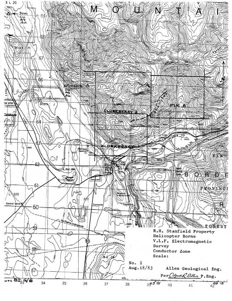
2 CONTENTS INTRODUCTION LOCATION AND ACCESSIBILITY TOPOGRAPHY HISTORY GEOLOGY PROPERTY HELICOPTER BORNE VLF ELECTROMAGNETIC AND MAGNETIC SURVEY SUMMARY AND CONCLUSIONS RECOMMENDATIONS COSTS STATEMENT REFERENCES CERTIFICATE CONSENT MAPS: 1. L ocation 2. V.L.F. Electromagnetic Survey Conductor Zone
3 A RECONNAISSANCE HELICOPTER BORNE V.L.F. 20 k h z RANGE ELECTROMAGNETIC AND MAGNETIC SURVEY BALSAM 1-12 CEDAR 1-2 CEDAR SOUTH 1-2 ELDERBERRY 1 ELDERBERRY 1-2 FORT STEELE M.D. B.C. INTRODUCTXON A helicopter borne geophysical survey was conducted over the subject claims area for R.H. Stanfield June 26-29, Apex Airborne Surveys Ltd., Howe Street, Vancouver, B. C., conducted the survey under the supervision of Mr. Ronald F. Sheldrake, B.Sc., president of the company. Copies of the report are included with the application for assessment credit on the subject claims. Field assistance was provided by Mr. Ross Stanfield, Jr., Mr. Brent Skene, and Mr. Claire Meglesh of the R.H. Stanfield staff. The writer is retained as consultant. The purpose of the survey was to detect structural as well as mineralized zones using the 20 k h z phase instrumentation and Hawaii (NPM) transmitter station. The object of this report is to provide basic regional geologic and topographic information involved with the interpretation of survey results.
4
5 LOCATION AND ACCESSIBILITY The Stanfield property is located in southeastern British Columbia, 27 kilometres east of Cranbrook. The surveyed area lies east of the Kootenay River and north of the Elk River. Access is via Highway #3 from Cranbrook. TOPOGRAPHY The property extends from the Rocky Mountain Trench, elevation 750 metres above sea level easterly, and includes the Hughes, Lizard and Steeples ranges of the Rocky Mountains, the upper levels of which exceed 2,500 metres elevation above sea level. Principal drainage is via the Kootenay River, Elk River, Bull River and Sand Creek. HI STORY Placer mining was active in the area from the 1860's. Mineral claims had been located on hardrock showings in The Sullivan mine was located in 1892 and the St. Eugene in The Strathcona-Empire was acquired by Colonel Samuel Steele in the 1890ls, The Estella and Kootenay King were located in the early 1900's. On the Stanfield holdings ore was shipped from the Strathcona- Empire in the latt 1930's and the Bull River mine operated from October 1971 until March Exploratory investigations have been conducted on the Stanfield holdings since the 19601s.
6 GEOLOGY The surveyed area is underlain by Precambrian red-to rustyweathering Aldridge quartzite, argillaceous quartzite and siltstone. To the east and north this formation is overlain by grey, green, purple and white quartzite and argillite of the Creston formation. The youngest member of the Precambrian sequence is the Kitchener formation which is composed of buff-to brownweathering dolomite with interbeds of grey and green argillite and grey limestone. The general attitude of the well bedded strata is a strike trend to the northwest and gentle dips from nearly flat to moderately steep to the northeast. Faulting is evident along the easterly side of the Rocky Mountain Trench. The most prominent fault strikes northesterly and dips steeply southwest. A few narrow lamprophyre dikes and one granodiorite dike occur to the east of the surveyed area. PROPERTY The primary claims are as follows: ( Map #2 ) Claims Cedar 1 and 2 Record Numbers 205 and 206 Ex. Dates June 17 Cedar South 1 and and 1545 Aug. 19 Balsam 1-12 inclusive , July Aug. 19 Elderberry Sept.I Elderberry South 1 and Sept. 1
7
8 HELICOPTER BORNE RECONNAISSANCE VLF ELECTROMAGNETIC SURVEY. MAGNETIC AND A helicopter borne V.L.F. electromagnetic and magnetic reconnaissance survey, using 20 khz phase instrumentation, was flown over the southwest area of the Stanfield property June 24-29, The field supervision was undertaken by Mr. Ronald F. Sheldrake, B. Sc., geophysicist. Interpretation and report preparation assistance was provided by Janan T. Sallomy, Ph.D., geophysicist. The helicopter engineer was Herman Lorenz and field technition was Michael Magee. Assistance was provided from the Stanfield camp by Ross Stanfield Jr., Brent Skene and Clare Meglesh. The writer assisted with the planning, interpretation and reporting of the survey. The Apex Airborne Surveys Ltd. report is included with this report in support of assessment requirements for the subject mineral claims.
9 SUMMARY AND CONCLUSIONS The helicopter borne geophysical survey over a part of the western section of the R.H. Stanfield holdings in the Fort Steele ~ining Division was undertaken with the purpose of acquiring information regardin possible mineral concentra- tions and structural data. The 20 khz V.L.F. purpose. the survey period. phase instrumentaion was used for this The Hawaii 23.4 khz transmitter was used throughout The magnetic field configuration was flat and nor mapped for the final report. The anomalous zone detected across the Elderberry 1 and 3 and Fir 6 claims - lines 8, 9 & 10, - will warrant ground invest- igations. It is concluded that detailed ground geophysical and geolog- ical investigations will be conducted over the anomalous zone. RECOMMENDATIONS A ground V.L.F. electromagnetic survey is reoommended over a 3 kilometre by 1 kilometre area to include the indicated conductor, zone on the Fir 6, Elderberry 1 and Elderberry' 3 claims. Respectfully submitted, Allen Geological Engineering Ltd. Pe P.Eng. West Vancouver, B. C. August 18, 1983.
10 COSTS STATEMENT Personnel:' 1. R.H. Stanfield A/C Alfred R. Allen, P. Eng., Planning, scheduling, interpretation, maps, report June, July, Aug. $350/day Ross Stanfield Jr., April, May, June $75?day 18 days..... $ 6, days , Brent Skene, " s $75/day 22 days , Clare Meglesh, " $75/day 21 days... 1, Apex Airborne Surveys A/C Rooms and meals, Stanfield camp, 12 man days kilometres flight $86.73/km... 32,960.00
11 REFERENCES Schofield. S.J., G.S.C. Cranbrook Map-Area, Mem Rice, H.M.A., G.S.C. Nelson Map-Area, East Half, Mem & 41 Leech, G.B., G.S.C. Fernie Map-Area, Paper Chiang, M. C., Placer Oil Company, Reports & Maps, Swanson, C.O. Gunning, H. C. & Geology - Sullivan Mine Sullivan Mine C.I.M.M. Trans. V XLVIII 1945 Cominco Staff, The Sullivan Mine, C.I.M.M. Journal 1954 Macdonald, B. C., Altemont ~xploration Holdings Allen, Alfred R., R.H. Stanf ield Holdings 1967 Allen, Alfred R., R. H. Stanf ield Holdings 1973 Allen, Alfred R., The Bull River Copper-Silver Gold Mine Allen, Alfred R., Allen, Alfred R., Preliminary Report Strathcona-Empire Vein System, 1976 Geology and Ore Potential, Stanfield Holdings in Southeastern British Columbia 1976 Ronald F. Sheldrake, Report on a Helicopter Multifrequency Electromagnetic and Magnetic Survey, June A.B.L. Whittles, Ph.D. Prospecting with Radio Frequency E.M in Mountainous Regions, B.C. Institute of Technology, Feb. 1969
12 Bellevue Avenue West Vancouver, B.C. v ~ V 1 ~ 6 CERTIFICATE August 18, I, Alfred R. Allen, certify that: I am a graduate of the University of British Columbia and hold the following degrees therefrom: BASc Geological Engineering 1939 MASc Geological Engineering 1941 I am a Life member of the Association of Professional Engineers of the Province of British Columbia. I have practised my profession for the past thirty-seven years. I hold no interest in the properties or securities of R.H. Stanfield, or affiliates thereof, nor do I expect to receive any directly or indirectly. The Report on the Reconnaissance Geophysical Survey Helicopter - Borne V.L.F. Electromagnetic and Magnetic, Galloway Area, Fort Steele M.D., B.C., is based on consulting by the writer from June 1983 to August 18, I consent to this report being filed with the British Columbia Securities Commission. Alfred R. Allen
13 Bellevue Avenue West Vancouver, B.C. V7V 1 ~ 6 British Columbia Securities Commission Vancouver, B. C. Dear Sirs: Re: R.H. Stanfield I hereby consent to the use of my report dated August 18, 1983, on the Reconnaissance Geophysical Survey Helicopter- Borne V.L.F. Electromagnetic and Magnetic, Galloway Area, Fort Steele M.D., B. C., in any prospectus or statement of meterial facts or other material to be filed with the British Columbia Securities Commission or the Vancouver Stock Exchange by R.H. Stanfield. Yours very truly, Klfred R. Allen. Eng.
COMINCO LTD. HORIZONTAL LOOP EM AND MAGNETIC SURVEYS ON SHA. CLAIMS 1, 2, 7 and 8 NELSON AND FORT STEELE MINING DIVISIONS, B.C.
 COMINCO LTD. EXPLORATION WESTERN DISTRICT NTS: 82-F/1 HORIZONTAL LOOP EM AND MAGNETIC SURVEYS ON SHA CLAIMS 1, 2, 7 and 8 - ASSESSMENT REPORT - NELSON AND FORT STEELE MINING DIVISIONS, B.C. Latitude Longitude
FILE NO. ASSESSMENT REPORT VLF-EM GEOPHY S I CS BUCK CLAIMS. Moyie River and Perry Creek Area FORT STEELE MINING DIVISION. NTS 82 F/8 E and 82 G/5 W
 FILE NO. ASSESSMENT REPORT on - VLF-EM GEOPHY S I CS BUCK CLAIMS Moyie River and Perry Creek Area FORT STEELE MINING DIVISION NTS 82 F/8 E and 82 G/5 W Latitude 49 27' N Longitude 116 03' W PETER KLEWCHUK
FttE NO: A I R. \qb6 J
 FttE NO: A I R. \qb6 J REPORT ON THE STEEPLJ3 PROPERTY GROUPS la - 8A PREPARED FOR: BUL RIVER MINERAL CORP. LTD. BY: ALFRED R. ALLEN P.ENG. ALLEN GEOLOGICAL ENGINEERING LTD. 827 West Pender Street Vancouver,
REPORT ON STEEPLE PROPERTY PREPARED FOR: BUL RIVER MINERAL CORP. LTD. BY: Alfred R. Allen, ALLEN GEOLOGICAL ENGINEERING LTD. # Moberley Road
 REPORT ON STEEPLE PROPERTY PREPARED FOR: BUL RIVER MINERAL CORP. LTD. BY: Alfred R. Allen, ALLEN GEOLOGICAL ENGINEERING LTD. #514-518 Moberley Road '!'?s'- ' Vancouver, B.C..i.2- * V5Z 4G3..---- \- 6 I
PHYSICAL WORK REPORT. the BAY CLAIMS. Omineca Mining Division Smithers, British Columbia N.T.S. 93E 13E/W
 PHYSICAL WORK REPORT the BAY CLAIMS Omineca Mining Division Smithers, British Columbia a N.T.S. 93E 13E/W LATITUDE: 53 57 00 N I LONGITUDE: 127 45 OO W for Home Ventures Ltd. 1201-675 West Hastings Street
/ UnwPis' R.H. / COMMOClrlES PrlESEriT A S S.E S S. f +'42 j FILMED
 ~~~.................~. 1......,.....,,... ~....,_ ~...............,,.,..,.? _*,,_ I... *.:.>.?;, *..,,:--... 3 r-< -.... TYPE OF REPDqT/SuRvEYiS: T..^,,... Drilling - $22,760.28 /PUTI~:?P~S Alfred. R..Allen...
CONSULTING GEOLOGICAL 8: MINING ENGINEERS STINGS STREET DA V6E 2E9 GEOPHYSICAL SURVEY SILVER QUEEN 2 ZEBALLOS AREA. B.C.
 DOLMAGE CAMPBELL & ASSOCIATES (1 975) LTD. CONSULTING GEOLOGICAL 8: MINING ENGINEERS STINGS STREET DA V6E 2E9 '' 1E O L 0 G I C A.L B'x;&a:f2:#& 'SESSMENT REPObT 12, Assessment RESOURCES LTD. 111 ReDort
Fox 2-Record No. 2524
 F HELICOPTER E.M. AND MAGNETOMETER SURVEY OVER THE FOX CLAIMS, OMINECA MINING DISTRICT BRITISH COLUMBIA ON BEHALF OF OWNER MR. MIKE BOYLE Claims: Fox l-record No. 2523 Fox 2-Record No. 2524 Location 126'
RECONNAISSANCE GEOCHEMICAL SURVEY
 RECONNAISSANCE GEOCHEMICAL SURVEY LEGAL, RITA, LOUISE FR. (CHAPLEAU GROUP) REVERTED CROWN GRANTS CHAPLEAU CREEK AREAJ, SLOC& MINING DIVISION 82 F/11W Lat: 49'44" Long: 117"22'W MINERAL RESOURCES BRANCH
GEOLOGICAL BRANCH ASSESSMENT REPORT 12. FItE NO: ACTION: THE GOLDEN MINING DIVISION, GOLDEN, Including THE NTS MAP; M82K/15W
 ACTION: FItE NO: Including 1990 GEO-CHEM SURVEY RESULTS -- THE AVD CLAIMS - THE GOLDEN MINING DIVISION, GOLDEN, B.C. NTS MAP; M82K/15W Lat. 50 deg. 55 Min. Long 116 deg. 55 min. For GEOLOGICAL BRANCH ASSESSMENT
Lat. 52' 43' N Long ' W
 &A exploration ltd MINING ENGINEERING GEOLOGY- GEOPHYSICS 4570 HOSKINS ROAD, NORTH VANCOUVER, 6. C. TELEPHONE (804) 985,7921 V7K 2R1 GEOLOGICAL AND GEOCHEMICAL REPORT on the BLUE CLAIMS Cariboo Mining
REPORT ON A GEOLOGICAL MAPPING AND PROSPECTING PROGRAM LOOK PROPERTY
 b KOKANEE EXPLORATIONS LTDI I WNO. 0 I- n c/ REPORT ON A GEOLOGICAL MAPPING AND PROSPECTING PROGRAM LOOK PROPERTY LOOK 1-31, 36-43 CLAIMS FORT STEELE MINING DIVISION CRANBROOK AREA N.T.S. 82G/5W + 4E E:
PHOENIX GEOPHYSICS LIMITED REPORT ON THE VLF-EM AND TOTAL FIELD MAGNETOMETER SURVEYS ON THE
 PHOENIX GEOPHYSICS LIMITED REPORT ON THE VLF-EM AND TOTAL FIELD MAGNETOMETER SURVEYS ON THE TAN CLAIMS, CHILLIWACK AREA NEW WESTMINSTER MINING DIVISION, BRITISH COLUMBIA FOR LORNEX MINING CORPORATION LIMITED
Prospecting Report 'S Office i DB Property, B.C. -J Negro Creek Nelson Mining District NTS 82F.050. Operator: Kootenay Gold Inc.
 . '.' I"' i9 12 Prospecting Report 'S Office i DB Property, B.C. -J Negro Creek Nelson Mining District NTS 82F.050 Operator: Kootenay Gold Inc. Owner: Darlene Lavoie Work Performed Summer of 2007 Report
HELICOPTER MAGNETIC SURVEY MISINCHINKA RANGE AREA, B.C. ONINECA MINING DIVISION. on behalf of STOKES EXPLORATION MANAGEMENT LTD.
 HELICOPTER MAGNETIC SURVEY MISINCHINKA RANGE AREA, B.C. ONINECA MINING DIVISION on behalf of STOKES EXPLORATION MANAGEMENT LTD. Claims : FALCON $1, FALCON #2 Location: Dated: About 7% kilometers N.E. of
for the Greenwood Mining Division, B.C. NTS 82E/7W Latitude 49' 27' W, Longitude 118' 5 Prepared by a= D. Dylan Watt, B.Sc.
 t. b LOGnO: 37~ -08 m. ACTIO#: for the AMP AMP 2 AMP 3 t AMP 4 CLAIMS Greenwood Mining Division, B.C. NTS 82E/7W Latitude 49' 27' W, Longitude 8' 5 %E c,w zc *& a w Prepared by a= -4c. D. Dylan Watt, B.Sc.
compietea since tnat date, and wnicn comprisea btage I ot tne recommended
 compietea since tnat date, and wnicn comprisea btage I ot tne recommended four-stage program. GEOLOGY & MINERALIZATION The property situate6 on the southeast slope of Nickel Plate Mtn., and within the
490 20' 30" North Latitude ' 30" West Longitude
 _._.. I CONSULTING GEOLOGISTS 605-602 WEST HASTINGS STREET, VANCOUVER, B.C. V6B 1P2 TELEPHONE: (604) 689-5533 6 I F: ASSESSMENT REPORT ON THE PATSY 1 MINERAL CLAIM ' '?%2% I WHISTLE CREEK, HEDLEY ARE L-l-
_.----." 2) Gravimetric Profiles... In Pocket TABLE OF CONTENTS PAGE - SUMMARY AN0 CONCLUSIONS... 1A GRAVIMETRIC SURVEY Field Procedures...
 Gravimetric Profiles... In Pocket TABLE OF CONTENTS PAGE - SUMMARY AN0 CONCLUSIONS... 1A GRAVIMETRIC SURVEY Field Procedures...") _.----." TABLE OF CONTENTS PAGE - SUMMARY AN0 CONCLUSIONS... 1A GRAVIMETRIC SURVEY... 1 Field Procedures... 1 Elevation and Horizontal Control... 2 Meter Procedures... 2 Computing Procedures... 2 Plotting...
_.----." TABLE OF CONTENTS PAGE - SUMMARY AN0 CONCLUSIONS... 1A GRAVIMETRIC SURVEY... 1 Field Procedures... 1 Elevation and Horizontal Control... 2 Meter Procedures... 2 Computing Procedures... 2 Plotting...
1 i I.; :<7 6EOLOGICAL BRANCH ASSESSMENT REPORT HLEM, VLF-EM AND MAGNETOMETER TEST SURVEY ON THE ARC PROPERTY FOR SURVEY BY SJ GEOPHYSICS LTD.
 f - ~ --- j LOG NO: MAR 2 a 1992,,, -- - - - -- L$TiC'P;: I.; 1 i HLEM, VLF-EM AND MAGNETOMETER TEST SURVEY ON THE ARC PROPERTY FOR SURVEY BY SJ GEOPHYSICS LTD. SLOCAN M.D., B.C. N.T.S. 88 F/10 d 2- :
7 MILES WEST OF PORT HARDY, B.C.
 GEOPHYSICAL REPORT VERTICAL INTENSITY MAGNETOMEER SURVEY ON LUK CLAIMS, 7 MILES WEST OF PORT HARDY, B.C. 50' 127O SE BY R. E. SHIELDS UNDER SUPERVISION OF J. R. BILLINGSLEY FOR SECOND0 MINING LTD. (N.
GEOLOGICAL SURVEY BRANCH ASSESSMENT REPORT
 GEOLOGICAL SURVEY BRANCH ASSESSMENT REPORTS DATE RECEIVED NOV 1 3 1996 ASSESSMENT REPORT -. on LINE CUTTING and DIAMOND DRILLING ABITIBI MINING CORPORATION BARR PROPERTY Palmer Bar Creek Area Fort Steele
cpw 6. E. Spencer Engineering Ltd. HANNA 9 M. C. 104 REP 0 RT DIAMOND DRILLING PROGRAMME LIARD MINING DISTRICT, K.T.S. FOR TAURUS RESOURCES LTD.
 6. E. Spencer Engineering Ltd. LlJ REP 0 RT ON DAMOND DRLLNG PROGRAMME cpw HANNA 9 M. C. LARD MNNG DSTRCT, K.T.S. 104 P@g FOR TAURUS RESOURCES LTD. BY B. E. SPENCER, P. ENG. B. E. SPENCER ENGNEERNG LTD.
EWS PETROLEUM CORPCWAT~ WEST HASTINGS STREET VANCOUVER, 8. C. V6C 186
 EWS PETROLEUM CORPCWAT~ 613-837 WEST HASTINGS STREET VANCOUVER, 8. C. V6C 186 GEOPHYSICAL REPORT on a VLF - ELECTROkAGNETlC SURVEY on the SHEBA MINERAL CLAIM CARIBOO MINING OIVISION NTS 93 H/3 Lat. 53
SUMMl'l WlLS LIU. GEOPHYSICAL REPORT. W. CT. a~evenson Y I
 SUMMl'l WlLS LIU. GEOPHYSICAL REPORT W. CT. a~evenson Y3 qi@, 1970. I 2-90 9 CONTENTS - PAGE Introduction... 1 Property... 1 Location and Access... 1 Survey Specifications Survey Grid... 1 Induced Polarization
PROSPECTORS ASSISTANCE PROGRAM MINISTRY OF ENERGY AND MINES
 BRITISH COLUMBIA PROSPECTORS ASSISTANCE PROGRAM MINISTRY OF ENERGY AND MINES GEOLOGICAL SURVEY BRANCH PROGRAM YEAR: 1999/2000 REPORT #: PAP 99-l 6 NAME: KIM ANSCHETZ PROSPECTORS TlEPORT on the 99 LOUIS
exploration I td. MINING ENGINEERING
 &A GEOLOGY GEOPHYSICS exploration I td. MINING ENGINEERING Suite 614-850 WEST HASTINGS STREET. VANCOUVER, B.C. TELEPHONE (604) 681-0191 V6C 1El GEOCHEMICAL AND GEOPHYSICAL REPORT on the SUMMIT PROPERTY
NTS 93L/9W GEOCHEMICAL AND GEOPHYSICAL REPORT MONA CLAIM OMINICA MINING DIVISION. Lati tude 54036'N; Longitude 'W
 GEOCHEMICAL AND GEOPHYSICAL REPORT ON MONA CLAIM OMINICA MINING DIVISION Lati tude 54036'N; Longitude 126018'W NTS 93L/9W April 1981 Paul Plicka Consulting Geologist LOCATION MAP INTRODUCTION TABLE OF
..!I AXE CLAIMS ON THE. for RICHCORE EXPLORATIONS LTO. GREENWOOD MINING DIVISION BRITISH COLUMBIA. Latitude 49O 30"; Longitude 118' 30'W NTS 82E/9W
 ON THE AXE CLAIMS for RICHCORE EXPLORATIONS LTO. GREENWOOD MINING DIVISION BRITISH COLUMBIA Latitude 49O 30"; Longitude 118' 30'W NTS 82E/9W... -... ~ i.,...._.'..!i Vancouver, B.C. September, 1980 P.
SELF POTENTIAL SURVEY OVER THE JAY GROUP, INVERMERE AREA GOLDEN MINING DIVISION, BFUTISH COLUMBIA NTS 82W8W7 82W9W LATLONG 50 30' ' FOR
 - GEOLOGICAL SURVEY BRANCH ASSESSMENT REPORTS -- -- DATE RECEI?/::D 06T 10 1996 - SELF POTENTIAL SURVEY OVER THE JAY GROUP, INVERMERE AREA GOLDEN MINING DIVISION, BFUTISH COLUMBIA NTS 82W8W7 82W9W LATLONG
ASSESSMENT REPORT ON THE PEAVINE PROJECT. DGW & Associates # Alberni Street, Vancouver, British Columbia, V6E 4V2
 ASSESSMENT REPORT ON THE PEAVINE PROJECT KAMLOOPS MINING DIVISION BRITISH COLUMBIA NTS 082M 12 Latitude 51 36' 19.0"North -- Longitude --119 47' 27.0"West UTM Zone 11, NAD 83 5720827N 306744E Prepared
49" 3-4 I4 I \ Y 59 tj
 ASSESSMENT REPORT Mary 4 FORT STEELE M.D. NTS 82G/5W 49" 3-4 4 \ Y 59 tj Owner: St. Eugene Mining Corporation Limited Operator : St. Eugene Mining Corporation Limited Author: John R. Wilson Date Submitted:
n3a 92 C- /.I 4 tr November 6, 1979 J. F. MclNTYRE, P.ENG. CONSU LTlNG MINING ENGl NEER Map #92C-16 TRANS PACIFIC VENTURES LTD.
 TELEPHONE : 5 9 6-1331 J. F. MclNTYRE, P.ENG. CONSU LTlNG MINING ENGl NEER 6466 CAGELDU CRESCENT DELTA, B.C. CANADA TRANS PACIFIC VENTURES LTD. c i. SAMPLING AND GEOPHYSICAL REPORT CAP CLAIM, VICTORIA
DEVELOPMENT REPORT. Lone I Mineral Claim Group. Wild Horse River Area Cranbrook, B.C.
 DEVELOPMENT REPORT Lone I Mineral Claim Group Wild Horse River Area Cranbrook, B.C. Fort Steele Mining District NTS 82G/12E 49 38 35 Latitude 115 38 00 Longitude LONE PEAK PLACER LTD. 514-13th Avenue South
GEOPHYSICAL REPORT ON AN INDUCED POLAR.IZATION SURVEY
 GEOPHYSICAL REPORT ON AN INDUCED POLAR.IZATION SURVEY T & V Claim Groups some 12 miles Northwest of Babine Lake, B.C. Latitude 55' 26'N Longitude 126' 35'W AUTHOR: Glen E. White, Chief Geophysicist,a,
PIOTR LUTYNSKI VANCOUVER, BRITISH COLUMBIA
 AN ASSESSMENT REPORT ON GROUND MAGNETIC SURVEYING CHUCHI PROPERTY FORT ST. JAMES AREA, BRITISH COLUMBIA OMINECA M.D. 55 17 N, 124 31 W NTS 93N/ 7&8 Claims Surveyed: 597976, 597878-597880 Survey Dates:
ASSESSMENT REPORT GEOLOGICAL BRANCH. 50' 23 'North. GEOLOGICAL and GEOCHEMICAL SURVEYS ON THE. PUTNAM PROPERTY (Putnam Mineral Claim)
") GEOLOGICAL and GEOCHEMICAL SURVEYS ON THE PUTNAM PROPERTY (Putnam Mineral Claim) VERNON MINING DIVISION, B.C. GEOLOGICAL BRANCH ASSESSMENT REPORT NTS : Latitude: 82L17W 50' 23 'North LOCATION, ACCESS,
GEOLOGICAL and GEOCHEMICAL SURVEYS ON THE PUTNAM PROPERTY (Putnam Mineral Claim) VERNON MINING DIVISION, B.C. GEOLOGICAL BRANCH ASSESSMENT REPORT NTS : Latitude: 82L17W 50' 23 'North LOCATION, ACCESS,
Gold Mountain Group Gold Mtn. A, B, C & D Mineral Claims Record Nos. 697, 698, 699 & 700. Island Mountain Cariboo Mining Division British Columbia
 GOLD POINT RESOURCES LTD. Geophysical Survey Gold Mountain Group Gold Mtn. A, B, C & D Mineral Claims Record Nos. 697, 698, 699 & 700 Island Mountain Cariboo Mining Division British Columbia Vancouver,
J.D. Mason, Prof. Engineer. Report on the Reconnaissance Magnetometer Survey. Completed for. North American Platinum Corporation Ltd.
 Report on the Reconnaissance Magnetometer Survey Completed for North American Platinum Corporation Ltd. Olivine Mountain Property, Tulameen, B.C. J.D. Mason, Prof. Engineer. November 28, 1967. Certificate
PROSPECTING REPORT THE WALLACE CLAIM OMENICA MINING DIVISION. 54" x6" 3.d d. for. Reako Exlorat ions Ltd. Wallace Rev. C.G.
 PROSPECTING REPORT ON THE WALLACE CLAIM OMENICA MINING DIVISION 54"44 14 1x6" 3.d d by David A. Howard P.Eng. for Reako Exlorat ions Ltd. Claim Locat ion Wallace Rev. C.G. #1560 Dome Mountain Area 9 3
32?un North of Hope, B.C.,
 Geological Reconnaissance Assessment Report on portions of the Gilt Creek Group (Mike, C.G., Julie, and Gilt Mineral Claims) Situated 32?un North of Hope, B.C., New Westminster Mining Division N 'P 97H/11W
SOIL GEOCHEMISTRY TUFA MINERAL CLAIM SLOCAN MINING DIVISION ZINCTON, B.C. NTS 82K 3E LATITUDE 50"02'20"N, LONGITUDE 117'11'W
 SOIL GEOCHEMISTRY TUFA MINERAL CLAIM SLOCAN MINING DIVISION ZINCTON, B.C. NTS 82K 3E LATITUDE 50"02'20"N, LONGITUDE 117'11'W LOCKE B. GOLDSMITH, P.ENG., P.GE0. CONSlULTING GEOLOGIST OCTOBER 30,2001 TABLE
VLF and GRADIOMETER SURVEY OVER THE CAT GROUP, INVERMERE AREA GOLDEN MINING DIVISION, BRITISH COLUMBIA NTS 82K/O8W LAT/LONG 50 29' ' FOR
 VLF and GRADIOMETER SURVEY OVER THE CAT GROUP, INVERMERE AREA GOLDEN MINING DIVISION, BRITISH COLUMBIA NTS 82K/O8W LAT/LONG 50 29' - 116 15' FOR W. POCHYLKO STETTLER, ALBERTA BY T.R.B. DUNDAS ISOGEOS EXPLORATION
Cominco ltd. REPORT OF GRID "C" GEOCHEMICAL SURVEY ON VINE 1 CLAIM, VINE 1, 25, 27 CLAIM GROUP Fort Steele Mining Division
 GOVERNMENT OFFICE Cominco ltd. EXPLORATION DIVISION REPORT OF GRID "C" GEOCHEMICAL SURVEY ON VINE 1 CLAIM, VINE 1, 25, 27 CLAIM GROUP Fort Steele Mining Division Submitted by: E.W. BATCHELOR Cominco Ltd.
4. Geological maps published by the Ontario Department of Mines.
 52J08NWei45 S2J08NWa6B1 SMYE 010 AMALGAMATED RARE EARTH MINES LTD. *, SAVANT LAKE PROSPECT x ONTARIO INTRODUCTION t This Is a report on a group of 28 claims control led by Amalgamated Rare Earth Mines
A REPORT. Bear Lake, British Columbia (56' 13'N, ~) N.T.S. 94 D U& Claims surveyed: BL 1, units 2
 N.T.S. 94 D U& Claims surveyed: BL 1, units 2") I PETER E. WALCOTl' Rr ASSOC. LTD. A REPORT AN INDUCED POLARIZATION SURVEY T.?. d." Bear Lake, British Columbia rnk (56' 13'N, 1270 49~) N.T.S. 94 D U& *o Claims surveyed: BL 1, units 2 *a* & 3 BL 2, units
I PETER E. WALCOTl' Rr ASSOC. LTD. A REPORT AN INDUCED POLARIZATION SURVEY T.?. d." Bear Lake, British Columbia rnk (56' 13'N, 1270 49~) N.T.S. 94 D U& *o Claims surveyed: BL 1, units 2 *a* & 3 BL 2, units
Dspartrnesrf of ASSESSMENT REPORT AEROMAGNETIC SURVEY BY CLAIM GROUP RACING RIVER AREA LIARD M.D., B.C. 9.1 K/II d
 Dspartrnesrf of r Mines and Petroleum Resources ASSESSMENT REPORT I NO., 2-k...+.A...,.. MAP...,...,...,...,.,.,...,.,.,, AEROMAGNETIC SURVEY TANJO MINES LTD. (N.P.L.) BY CLAIM GROUP RACING RIVER AREA
BGND 2-7 CLAIMS, KELOWNA, B.C.
 GEOLOGICAL EVALUATION of BGND 2-7 CLAIMS, KELOWNA, B.C. 5"'33"N; 9"33'3"W:NTS 82L/4E BEAR CREEK: 4Km NNW of Kelowna Vernon Mining Div., British Columbia by N. C., P.Geol., P. Eng. Consulting Geologist,
t+o...&zz!. ASSESSMENT REPORT Department of Miner and Petroleum Resources MAP.,- INDUCED POLAKIZATION SURVEY OVER THE BROOKS PROSPECT
 5873 INDUCED POLAKIZATION SURVEY OVER THE BROOKS PROSPECT BROOKS PENINSULA AREA VANCOUVER ISLAND, B.C. NANAIMO AND ALBERNI MINING DIVISIONS BY Z. B. DOBORZYNSKI JANUARY, 1976 Department of Miner and Petroleum
1 CLAIMS GEOPHYSICAL REPORT ON BOYAL SITUATE NORTHEAST OF TILLICUM MOUNTAIN GOLD AREA BURTON - NAKUSP SIQCAEJ MINING DIVISION
 GEOPHYSICAL REPORT ON BOYAL 1 CLAIMS SITUATE NORTHEAST OF TILLICUM MOUNTAIN GOLD AREA BURTON - NAKUSP SIQCAEJ MINING DIVISION CONSULTING GEOLOGIST AUGUST 1983 VANCOUVER B *C INDEX INTRODUCTION ooa,.eoaaa.aaaoaaooaoa~ao~o
"E r * Xk LJ* a4w. rc&
 g3-*39s --"I144 I GEOLOGY- GEOPHYSICS 4570 HOSKINS ROAD, NORTH VANCOUVER, 6. C. TELEPHONE (804) 985.7921 V7K 2R1 GEOCHEMICAL AND GEOPHYSICAL REPORT on the JERO 1 to 4 CLAIMS (Ross land Property) Trail
BALFOUR MINING LTD. (N.P.L.) HAM GROUP 92-P-6, CLINTON M. D.8 B. C. Lat 51 17'N, GEOCHEMICAL REPORT. V. CUKOR, P. Eng.
 HAM GROUP 92-P-6, CLINTON M. D.8 B. C. Lat 51 17'N, GEOCHEMICAL REPORT. V. CUKOR, P. Eng.") 34q '7 BALFOUR MINING LTD. (N.P.L.) HAM GROUP 92-P-6, CLINTON M. D.8 B. C. Lat 51 17'N, Long 12lo14'W GEOCHEMICAL REPORT, V. CUKOR, P. Eng. January 31, 1972 TABLE OF CONTENTS 1. INTRODUCTION 2. PROPERTY,
34q '7 BALFOUR MINING LTD. (N.P.L.) HAM GROUP 92-P-6, CLINTON M. D.8 B. C. Lat 51 17'N, Long 12lo14'W GEOCHEMICAL REPORT, V. CUKOR, P. Eng. January 31, 1972 TABLE OF CONTENTS 1. INTRODUCTION 2. PROPERTY,
ASSESSMENT REPORT ON THE VLF-EM SURVEY. Trail Creek Mining Division NTS: 82 F/4 W Longitude: 1 17' 49' 50" Latitude: 49O 03' 40"
 ASSESSMENT REPORT ON THE JERO 5 MINERAL CLAIM ROSSLAND, BRJTISH COLUMBIA VLF-EM SURVEY Trail Creek Mining Division NTS: 82 F/4 W Longitude: 1 17' 49' 50" Latitude: 49O 03' 40" Owner: Operator: Author:
B.C. Vancouver, Sritish Columbia. Ragas Claims, Omenica M.D., A GEOPHYSICAL REPORT. A GROUKD NAGMETIC 6: ELECTRO?.IAGr\TETIC SURVEY FOR
 A GEOPHYSICAL REPORT A GROUKD NAGMETIC 6: ELECTRO?.IAGr\TETIC SURVEY Ragas Claims, Omenica M.D., B.C. FOR CATRE - 3EK JOINT VENTURE PETER E. WALCOTT & ASSOC. LIPIITED Vancouver, Sritish Columbia OCTOEEEt
1 FILMED 1. FILE NO:!..rsrru -* -. GRAND TWO CLAIM
 FILE NO:!..rsrru -* -. GRAND TWO CLAIM REPORT ON 1993 ASSESSMENT WORK GRAND TWO CLAIM REC. NO. 301849 NELSON MINING DIVISION NTS MAP SHEET 82F6/W 49 25'51" NORTH 117 18'08" WEST 1 FILMED 1 AUTHOR: R. Jordan,
GEOPHYSICAL ASSESSMENT REPORT (TOP & BOTTOM CLAIMS) MCINTYRE LAKE. VERNON MINING DIVISION, B-Cm
 MCINTYRE LAKE. VERNON MINING DIVISION, B-Cm") GEOPHYSICAL ASSESSMENT REPORT on the TOP PROPERTY (TOP & BOTTOM CLAIMS) MCINTYRE LAKE VERNON MINING DIVISION, B-Cm NTS : Latitude: 50'04' North Longitude: Owner: Consultant : Author : 118'33 ' West Brican
GEOPHYSICAL ASSESSMENT REPORT on the TOP PROPERTY (TOP & BOTTOM CLAIMS) MCINTYRE LAKE VERNON MINING DIVISION, B-Cm NTS : Latitude: 50'04' North Longitude: Owner: Consultant : Author : 118'33 ' West Brican
GEOCHEMICAL/GEOPHYSICAL/GEOLOGICAL REPORT
 GEOCHEMICAL/GEOPHYSICAL/GEOLOGICAL REPORT OM SOIL GEOCHEHISTRY AND VLF-EM SURVEYS With Geological mapping^ OVER THE TAKU 2, DOEERTY, AND B.G.T. CLAIMS BREWERY CREEK, FORT STEELE AREA FORT STEELE.MINING
GEOPHYSICAL REPORT. Airborne Magnetometer Survey. of the SHEEP-GOAT GROUP OF MINERAL CLAIMS. near Li l looet, B.C.
 GEOPHYSICAL REPORT 977 Airborne Magnetometer Survey of the SHEEP-GOAT GROUP OF MINERAL CLAIMS near Li l looet, B.C. Lillooet Mining Division (Lat.51 'lot Long. 122 40' 7 5t0[2L05E. for DUFFEY LAKES MINES
GEOPHYSICAL REPORT INDUCED POLARIZATION/RESISTMTY SURVEYS. on behalf of TEESHIN REOURCES LTD Argus Road. Oakville, Ontario L6J 354
 GEOPHYSICAL REPORT INDUCED POLARIZATION/RESISTMTY SURVEYS DOME MOUNTAIN PROPERTY, SMITHERS AREA CHRIS, APRIL 1, APRIL 2, APRIL 3, AND MAG 1 CLAIMS CMINECA MINING DMSION, BRITISH COLUMBIA Latitude: 546
r Department of Mines and P,1Pr2!sum Resources I ... ' AS f 5 5 E t.! T R E p (J RT Mt, Sicker, Duncan Area, Vancouver Island, B.C.
 45- I A REPORT - ON AN ELECTROMAGNETIC SURVEY Mt, Sicker, Duncan Area, Vancouver Island, B.C. DUCANEX RESOURCES LIMITED Vancouver, British Columbia r Department of Mines and P,1Pr2!sum Resources I AS f
'-7' REPORT ON A MAGNETOMETER SURVEY OVER PART OF THE MAX CLAIM GROUP 1-20 LAC LE JEUNE AREA KAMLOOPS MINING DIVISION KAMLOOPS, BRITISH COLUMBIA
 I,., - SUITE 102. 222 BELLEVUE WES t ANCOUVER, B. '-7' REPORT ON A I MAGNETOMETER SURVEY OVER PART OF THE MAX CLAIM GROUP 1-20 LAC LE JEUNE AREA KAMLOOPS MINING DIVISION KAMLOOPS, BRITISH COLUMBIA 50-30
Bull River Copper-Silver-Gold Prospect, Purcell Supergroup, Southeastern British Columbia
 Bull River Copper-Silver-Gold Prospect, Purcell Supergroup, Southeastern British Columbia Trygve Höy, W.R. Smyth and Ray E. Lett British Columbia Geological Survey, Ministry of Energy and Mines, Victoria,
GEOLOGICAL, GEOCHEMICAL, GEOPHYSICAL, & PHYSICAL ASSESSMENT REPORT ON THE MISTY -NIE-SAM PROPERTY ATLIN MINING DIVISION N.T.S.
 GEOLOGCAL, GEOCHEMCAL, GEOPHYSCAL, & PHYSCAL ASSESSMENT REPORT ON THE MSTY -NE-SAM PROPERTY Claims: MSTY (20883) MSTY 2 (20884) NE (20903) NE 2 (20904) POLE (20 885) SAM (20844) SAM 2 (20845) ATLN MNNG
Negro Creek Fort Steele Minina Division. CRAIG KENNEDY Prospector
 AUG and SKAY Claims Negro Creek Fort Steele Minina Division NTS 82 F8/E Latitude 49O28 N Lonqi tude 116 Ol W BY CRAIG KENNEDY Prospector September 5, 1996 TABLE OF CONTENTS Page 1.00 INTRODUCTION 1.10
REPORT. on the. Omineca Mining Division, British Columbia. Latitude N., Longitude W. NTS map sheet 93F/7E. James W. McLeod, P.Geo.
 REPORT on the CHU MOLYBDENUM PROPERTY Omineca Mining Division, British Columbia Latitude 53 21 N., Longitude 124 37 W. NTS map sheet 93F/7E James W. McLeod, P.Geo. on behalf of Mr. Chris Delorme TABLE
GEOPHYSICAL REPORT THE CAVZ CLAIMS
 GEOPHYSICAL REPORT Magnetometer Survey on THE CAVZ CLAIMS CAVZ M.C.'s 1 to 12, 15 to 26, 29 to 40, 45 to 54 Trail Peak, Omineca M.D. 13 miles northeast of Fort Babine 550 ) 126 S.E. by G.Podolsky J.Russell
I - t RD. CONTENTS ... FIGURES Conclusions Physiography... Introduction... Locat ion...
 CONTENTS RD. - t 1. 2. ntroduction Locat ion 3. Physiography 1 4. Geology 1 5. Objectives 2 6. Results 3 7. Conclusions 4 8. Statement of Costs 9. References 10. Certificate FGURES Figure 1 Site Location
entire 1.5 meter drift width
 GOLD HILL SUMMARY In 1864 gold fever struck in the south Kootenays east of Cranbrook, British Columbia as placer gold was discovered in the Wild Horse River. What followed was everything one can imagine
GEOPHYSICAL REPORT ON A VLF-EM SURVEY OVER THE BOSS 1 AND 2 CLAIMS HEDLEY AREA SIMILKAMEEN MINING DIVISION BRITISH COLUMBIA
 GEOPHYSICAL REPORT i ON A VLF-EM SURVEY OVER THE BOSS 1 AND 2 CLAIMS HEDLEY AREA SIMILKAMEEN MINING DIVISION BRITISH COLUMBIA PROPERTY SURVEYED BY : 11.0 h S60W of Bedley : 49' 120O SE : N.T.S. 92~18~
A Report on a Magnetometer Survey. Division, British Columbia. Gypsy 1-32 and Gypsy 1 Fr-9 Fr. 27 miles north of Smithers
 - A Report on a Magnetometer Survey on the Gypsy Claims, Omineca Mining Division, British Columbia Covering: Gypsy 1-32 and Gypsy 1 Fr-9 Fr Located: 27 miles north of Smithers Latitude 55O11' N Longitude
Assessment Work Report. on the Geophysical Surveys carried out over the
 Assessment Work Report on the Geophysical Surveys carried out over the PINE GROUP of Mineral Claims 951-J-15-W Lillooet Mining Division Goldbridge, B.C. Long 122 48' Lat. 50 48' by Levon Resources Ltd.
GEOPHYSICAL REPORT CHU CHUA PROJECT Green Mountain Group. KAMLOOPS MINING DIVISION NTS 92P/8E, 82M/5W Lat: 51'24' N Long: 120'00' w
 I GEOPHYSICAL REPORT CHU CHUA PROJECT Green Mountain Group KAMLOOPS MINING DIVISION NTS 92P/8E, 82M/5W Lat: 51'24' N Long: 120'00' w I rvm #.,_..._..._._._.- $...-...! 1 VANCOUVER, B.C. 1 G E 0 I, 0.G
Darnley Bay Resources Preliminary Airborne Survey Results
 4 King Street West, Suite 1103 Toronto, Ontario M5H 1B6, Canada Tel:(416) 862-7885 Fax:(416) 862-7889 dbr@darnleybay.com UPDATE Trading Symbol: DBL. TSX Venture Exchange April 19, 2010 Darnley Bay Resources
---.,- A.S. ASH'TON, P. ENG. Delta, B.C. REPORT AMORE GROUP VICTORIA MINING DIVISION 32 KM S.S.W. OF NANAIMO, B.C. N.T.S.
 REPORT ON AMORE GROUP VICTORIA MINING DIVISION 32 KM S.S.W. OF NANAIMO, B.C. LATITUDE 48O57' N LONGITUDE 124O18' W N.T.S. 92C/16 W FOR AQUARIUS RESOURCES LTD. 11450-124 Street, Edmonton, Alberta. T5M OK3
BALTO RESOURCES LTD. (Owner & Operator) GEOPHYSICAL ASSESSMENT REPORT. (Event Number ) on the SED MINERAL CLAIM.
 GEOPHYSICAL ASSESSMENT REPORT. (Event Number ) on the SED MINERAL CLAIM.") BALTO RESOURCES LTD. (Owner & Operator) GEOPHYSICAL ASSESSMENT REPORT (Event Number 5173274) on the SED MINERAL CLAIM (Tenure 392163) Kamloops Mining Division NTS 092I.047 Centre of Work 5589550N, 667600E
BALTO RESOURCES LTD. (Owner & Operator) GEOPHYSICAL ASSESSMENT REPORT (Event Number 5173274) on the SED MINERAL CLAIM (Tenure 392163) Kamloops Mining Division NTS 092I.047 Centre of Work 5589550N, 667600E
GEOPHYSICAL REPORT ON A VLF-EM SURVEY OVER THE ADAMS PLATEAU CLAIMS SPILLFAN CREEK, UMLOOPS I5.B. BRTTISX COLbMBIA. : 7.0 Ian due east of Adams Lake
 GEOPHYSICAL REPORT ON A VLF-EM SURVEY OVER THE ADAMS PLATEAU CLAIMS SPILLFAN CREEK, UMLOOPS I5.B. BRTTISX COLbMBIA CZZTER OF CLAIMS : 7.0 Ian due east of Adams Lake : N.T.S. 3 2 ~ 1 4 ~ +7! SITTEN FOX
for the Greenwood Mining Division, B.C. NTS 82E/7W 29' W, Longitude 118' 53' N Prepared by D. Dylan Watt, B.Sc.
 for the FltE NO: u VOLT 1, VOLT 2, VOLT 3, & VOLT 4 CLAIMS Greenwood Mining Division, B.C. NTS 82E/7W Latitude 49' 29' W, Longitude 118' 53' N Prepared by D. Dylan Watt, B.Sc. #309-1996 Trutch Street Vancouver,
PRECIOUS METALS. owner. JMT Services Corp. GEOCHPlICAL SAMPLING CHELASLIE WCE, NORTH CENTRAL, B.C. OMINECA MINING DIVISION NTS 93F/5E & 6W
 PRECIOUS METALS REPORT ON 1980 RECONNAISSANCE GEOCHPlICAL SAMPLING CHELASLIE WCE, NORTH CENTRAL, B.C. OMINECA MINING DIVISION NTS 93F/5E & 6W LATITUDE 53O28 N LONGITUDE 125O31 W DATES Qp WORK: JULY 10
SUPPLEMENT TO MAGNETOMETER 6 ELECTROMAGNETIC SURVEY REPORT. DATED NOVEMBER l, 1973 CIGLEN INVESTMENTS LIMITED CLAIMS GROUP BAD VERMILLION LAKE AREA
 ^ A R l ^ 1974 010 PROJECTS UNIT SUPPLEMENT TO MAGNETOMETER 6 ELECTROMAGNETIC SURVEY REPORT DATED NOVEMBER l, 1973 CIGLEN INVESTMENTS LIMITED CLAIMS GROUP BAD VERMILLION LAKE AREA DISTRICT OF RAINY RIVER
REPORT ON GEOPHYSICAL SURVEYS. ASTA AND RITA CLAIMS Nanaimo Mining District NTS 92L1 Latitude 58' 08'N Longitude 126O 12'W for FALCONBRIDGE LTD.
 REPORT ON GEOPHYSICAL SURVEYS ASTA AND RITA CLAIMS Nanaimo Mining District NTS 92L1 Latitude 58' 08'N Longitude 126O 12'W for FALCONBRIDGE LTD. Vancouver, B. C. November, 1 984 J. L. Lebel, P. Eng. MPH
ASSESSMENT' REPORT GEOPHYSICAL REPORT ON THE ATTORNEY 2 CLAIM (4 UNITS) OMINECA MINING DIVISION SHEILA A. CRAWFORD.
 OMINECA MINING DIVISION SHEILA A. CRAWFORD.") ASSESSMENT' REPORT GEOPHYSICAL REPORT ON THE ATTORNEY 2 CLAIM (4 UNITS) OMINECA MINING DIVISION by SHEILA A. CRAWFORD LOCATION: 57z17' N Latitude 127 11' W Longitude N.T.S. 94E/6E OWNER/OPERATOR: SEREM
ASSESSMENT' REPORT GEOPHYSICAL REPORT ON THE ATTORNEY 2 CLAIM (4 UNITS) OMINECA MINING DIVISION by SHEILA A. CRAWFORD LOCATION: 57z17' N Latitude 127 11' W Longitude N.T.S. 94E/6E OWNER/OPERATOR: SEREM
NEW HAZELTON, OMINECA M.D.,
 PROSPECTING REPORT JUDI 1 TO 6 MINERAL CLAIMS NEW HAZELTON, OMINECA M.D., B.C. MAP 93M/4E, LAT. SS014'N, LONG. 127'33'W OWNED BY: A. L'ORSA ANTHONY L'ORSA Smithers, B.C. 21 February, 1981 TABLE OF CONTENTS
Trout Lake Area, British Columbia (500, 50' N., 117O 40' t?) Claims surveyed: WE, VIK. Survey Dates: June 6th - " 12th, 84 FOR
 Claims surveyed: WE, VIK. Survey Dates: June 6th - 12th, 84 FOR") PETER E. WALCOTT Rr ASSOC. LTD. P ~ L C ~ \%%95 GEOLOGICAL BRANCH ASSb:fiSMENT REPOPT A GEOPlIYSICAL REPORT Trout Lake Area, British Columbia (500, 50' N., 117O 40' t?) Claims surveyed: WE, VIK Survey
PETER E. WALCOTT Rr ASSOC. LTD. P ~ L C ~ \%%95 GEOLOGICAL BRANCH ASSb:fiSMENT REPOPT A GEOPlIYSICAL REPORT Trout Lake Area, British Columbia (500, 50' N., 117O 40' t?) Claims surveyed: WE, VIK Survey
REPORT ON Y ~L/~E A TURAM ELECTROMAGNETIC SURVE'Y HOUSTON AREA, BRITISH COLUMBIA ON BEHALF OF PERRY, KNOX AND KAUFMAN, INC
 REPORT ON Y ~L/~E A TURAM ELECTROMAGNETC SURVE'Y HOUSTON AREA, BRTSH COLUMBA ON BEHALF OF PERRY, KNOX AND KAUFMAN, NC TABLE OF CONTENTS Page No., NTRODUCTON DESCRPTON OF METHOD AND NSTRUMENTATON GEOLOGY
--_- A GEOPHYSICAL REPORT AN INDUCED POLARIZATION-SURVEY EQUITY SILVER MINES LIMITED_. John Wesley Ma11 Daniel Morice Merkley Gloria May Merkley
 --_- PETER E. WALCOTI' & ASSOC. LTD. A GEOPHYSICAL REPORT ON AN INDUCED POLARIZATION-SURVEY Houston Area, British Columbia 54O 27'N, 126" 39'W N.T.S. 93L/7E Claims sur-ed: HD 3 & 4 Survey Dates: Sept 16th
2013 GEOLOGICAL ASSESSMENT REPORT SHERIDAN HILL PROPERTY
 2013 GEOLOGICAL ASSESSMENT REPORT ON THE SHERIDAN HILL PROPERTY NEW WESTMINSTER MINING DIVISION BRITISH COLUMBIA NTS 092G07 49 16 31 NORTH LATITUDE, 122 39 48 WEST LONGITUDE PREPARED FOR Sheridan Hill
GEOLOGICAL MAPPING REPORT ON THE ASH MINERAL CLAIM OSOYOOS MINING DIVISION ASHNOLA RIVER MAP SHEET NTS M092,H019 MCBRIDE CREEK AREA, ASHNOLA RIVER,
 GEOLOGICAL MAPPING REPORT ON THE ASH MINERAL CLAIM OSOYOOS MINING DIVISION ASHNOLA RIVER MAP SHEET NTS M092,H019 LATITUDE 49 o O6, LONGITUDE 120 o 22 MCBRIDE CREEK AREA, ASHNOLA RIVER, KEREMEOS, B.C. CANADA
( ) and Thompson (1962al. The area immediately to the north is presently beiny studied by T.
 and Thompson (1962al. The area immediately to the north is presently beiny studied by T.") GEOLOGY OF THE PURCELL SUPERGROUP BETWEEN WILDHORSE RIVER AND SAND CREEK (82G/6,111 By Margaret E. McMechan Graduate Student Department of Geological Sciences, Queen s University INTRODUCTION This study
GEOLOGY OF THE PURCELL SUPERGROUP BETWEEN WILDHORSE RIVER AND SAND CREEK (82G/6,111 By Margaret E. McMechan Graduate Student Department of Geological Sciences, Queen s University INTRODUCTION This study
N. Lat. 50' 34' W. Long. 120' 33'
 ASSESSMENT REPORT ON THE HANK I MINERAL CLAIM RECORD NO. 2831 (7) CHERRY CREEK AREA KAMLOOPS MINING DIVISION KAMLOOPS, BRITISH COLUMBIA N. Lat. 50' 34' W. Long. 120' 33' 92 - I - 10E for ANGLO WESTERN
58 l'gr'n 'E. Date: January 23, 1979 ASSESSMENT REPORT PLACER SAMPLING & JADE BOULDER EVALUATION PLACER LEASE Liard Mining Divison 1041/7E
 ASSESSMENT REPORT PLACER SAMPLING & JADE BOULDER EVALUATION PLACER LEASE 1711 Liard Mining Divison 1041/7E 58 l'gr'n 18 38'E Owner & operator: Cry Lake Jade Mines Ltd. Author: A.M. Homenuke, P.Eng. Date:
PROSPECTING REPORT. Silver Dollar Property. EVENT # TENURE # Tenure Name: GPEX Silver Dollar
 2008-2009 PROSPECTING REPORT Silver Dollar Property EVENT # 4267989 TENURE # 555462 Tenure Name: GPEX Silver Dollar Similkameen Mining Division Map 092H Central Coordinate Reference 120 06 26.9 W Longitude
COMINCO LTD. GRID A VINE CLAIM GROUP. Fort Steele Mining Division 82G/5. Sulilnit t ed by :
 COMNCO LTD. EXPLORATON DVSON WESTERN DSTRCT REPORT ON GEOCHEMCAL SURVEY GRD A VNE CLAM GROUP Fort Steele Mining Division 82G/5 Sulilnit t ed by : E.W. BATCHELOR Cominco Ltd. Kootenay Exploration 2450 Cranbrook
GEOCSZNICAL - SURVEY. ICAMLOOPS Kl.D. 2'' 6;kr. HY "'f. Alfred R. Allen,P.Eng. 1 NO.%=...,... 6"- 'I.
 t i.i GEOCSZNICAL - SURVEY i p' ICAMLOOPS Kl.D. 2'' 6;kr HY 50-64 +."'f 121-51 NE 5-10-70 : 19-10-70 Alfred R. Allen,P.Eng. I) ' 1 6"- 'I. 1 NO.%=...,..... Q.C. EXPLORATIONS LTD. 2Cl- 535 Kowe Street Vancouver
REPORT ON MAGNETOMETER SURVEY TIK-1 CLAIM e&f KAMLOOPS MINING DTVISION. by D. Hendry D. C. MILLER. February 3, for
 REPORT ON MAGNETOMETER SURVEY TIK-1 CLAIM 92-1-14 e&f KAMLOOPS MINING DTVISION lat. 50 57 ' 12" long. 121O23 ' 37" OWNER: ST. JOSEPH EXPLORATIONS LIMITED OPERATIOR: ST. JOSEPH EXPLORATIONS LIMITED by D.
Geochemical Assessment Report. on the. Situated Nineteen Kilometres rth-northeast of Hope, B. C. in the. New Westminster Mining Division
 7 I Geochemical Assessment Report r on the r- I 1 Norm 1 to Norm 4 Mineral Claims c - I - 7 Situated Nineteen Kilometres rth-northeast of Hope, B. C. in the New Westminster Mining Division itude 49*32'N.,
L FILMED I GEOLOGICAL BRANCH ASSESSMENT REPORT. on the. in the. A Geological Report. situated. Nelson Mining Division
 A Geological Report on the GOV 5 Claim situated 4 km north of Creston, B.C. in the Nelson Mining Division N.T.S. 82pF/7tEf Lat: 49m1 N Long: 116'4.5'W 24.8' Dates of Work: 11-1 September 1986 Date of Report:
ASSESSMENT REPORT TITLE PAGE AND SUMMARY
 ASSESSMENT REPORT TITLE PAGE AND SUMMARY TITLE OF REPORT: Assessment Report on Andys Bridge Mineral Claim, Turnagain River Area TOTAL COST: $2,100 AUTHOR(S): Bruce w Downing SIGNATURE(S): Bruce W Downing
CONTENTS. Location, Access and History...6. Tenure Status and Geology Regional Andy Property Geology Map...9
 TYPE OFWORK IN THIS REPORT EXTENT OF WORK (rn METRTC UNITS) ON WHICH CLAIMS PROJECT COSTS APPORTIONED (incl. support) GEOLOGICAL (scale, area) Ground, mapping Photo interpretation GEOPHYSICAL (line-kilometres)
Vancouver, B.C., V6C 2T7
 GEOPHYSICAL REPORT WJP-EM SURVEY OVER A PCRTIOEi OF THE WELL 1, WELL 2 AND LEADER 4 CLAIMS ANGUS CREEK, CRAYEROOK AREA I FORT STEELE MINING DIYISIOU PROPERTY WRITTEN FQR : 26 km west of Cranbrook, B.C.
ASSESSMENT REPORT I.P./RESISTIVITY AND MAGNETICS SURVEY ON THE HAUTETE PROPERTY LATITUDE: 55O 12' N LONGITUDE: 126O 07' W
 NTS: 93W1 ASSESSMENT REPORT I.P./RESISTIVITY AND MAGNETICS SURVEY ON THE HAUTETE PROPERTY LATITUDE: 55O 12' N LONGITUDE: 126O 07' W OMINECA MINING DISTRICI'. B.C. CLAIMS COVERED : TET 1-8 TIME PERIOD: