Background information of groundwater dependent ecosystems (GDE) on Estonian Gauja-Koiva river basin
|
|
|
- Ambrose Banks
- 5 years ago
- Views:
Transcription
1 Background information of groundwater dependent ecosystems (GDE) on Estonian Gauja-Koiva river basin Elve Lode & Martin Küttim
2 Content Some facts about the Koiva river Something about GDEs Ecological data base of GDEs in Koiva river catchment Known spring-fens in Koiva river catchment

3 Location of Koiva river and it catchment Length of the Koiva river (in Estonia) = 26 km, i.e. between km from the mouth of the Gauja river Catchment area (in Estonia) = 1302 km 2 (ca 25% from all Gauja river catchment) (EELIS data base; Eesti NSV jõgede, ojade ja kraavide ametlik nimestik, 1986)

4 Koiva river stream network The longest river in the catchment is the Mustjõgi river (L= 84 km, F= 1820 km 2, in Estonia 994 km 2 ) Totally there are about 50 flowing water bodies in the Koiva river basin data base, but 80% of them are brooks (EELIS data base; Eesti NSV jõgede, ojade ja kraavide ametlik nimestik, 1986)
 are wetlands which critically depend on groundwater flows and")
 Availability of sufficient water (mainly from the atmosphere) b)")
5 Groundwater-Dependent Ecosystems (GDEs) are ecosystems that rely upon groundwater for their continued existence Groundwater-Dependent Terrestrial Ecosystems (GWDTEs) are wetlands which critically depend on groundwater flows and /or chemistries Prerequisites for occurrence of GDEs or GWDTEs P 1. General atmosphere-ground conditions a) Availability of sufficient water (mainly from the atmosphere) b) Availability to form recharge and discharge areas on the landscape

6 2. Interaction between general hydro-geological conditions and surface topology, i.e. type of GDEs or GWDTEs a) Availability to form regional groundwater dependent ecosystems on the landscape or a) Availability to form local groundwater dependent ecosystems on the landscape

7 3. Ecosystem dynamics within non-disturbed atmosphere-hydro-geologic-surface topology conditions, - as a reference a) Dynamics of discharge area hydrology, i.e. water quantity and quality in wet phase and dry phase b) Dynamics of ecosystems plant cover, i.e. horizontal zonation and it dynamics in wet phase and dry phase Example of ecological zonation of regional groundwater dependent ecosystem on the ground 1. Zone of permanent inundation and/or flowing discharge 2. Zone of aeration and reduced saturation 3. Saturated shoulder of the mound 4. Non-wetland area 5. Discharge tail during the wet phase 6. Wetland to non-wetland transition zone 7. Discharge tail during dry phase 8. Discharge tail during the dry phase Type 1a Wetlands located in off-stream environments, within floodplains


8 Example of ecological zonation of regional groundwater dependent ecosystem Example of ecological zonation of mixed groundwater dependent ecosystem and influenced by surface water flows Type 2 Semi-permanent brackish, palustrine wetlands with minor wetland soils and minor vegetation cover, mainly connected to regional groundwater systems Type 3 Permanent to semi-permanent riverine wetlands with minor wetland soils and moderate vegetation cover, sourced from local and regional groundwater systems and significantly influenced by surface water flows type-2 & type-3


9 Examples of ecological zonation of local groundwater dependent ecosystem Type 4 & 5 Semi-permanent fresh riverine-to-palustrine wetlands with minor wetland soils and moderate vegetation cover, mainly connected to local groundwater systems. 4 & type-5
10 Questions needed to answer * What is the list of the terminology what we will agree to use? Groundwater-Dependent Ecosystems (GDEs) (are ecosystems that rely upon groundwater for their continued existence) or Groundwater dependent terrestrial ecosystems (GWDTEs) (are wetlands which critically depend on groundwater flows and /or chemistries) * What is the spring mire? Not all fens are the spring mires and not all springs are forming spring mires! * What are the threshold values (TVs) for the GDEs or GWDTE? (Groundwater dependent terrestrial ecosystem (GWDTE) threshold values (TVs) are groundwater chemical concentrations which have been derived from empirical evidence) * How to mesaure and report the ecosystem conditions? 1) General atmosphere-ground conditions 2) Interaction between general hydro-geological conditions and surface topology 3) Ecosystem dynamics within non-disturbed atmosphere-hydro-geologic-surface topology conditions, as a reference 4) Disturbances

11 Ecological data base of Koiva river catchment Red polygons 1. Matsi spring mire 3 areas 2. Varstu spring mire 1 area Green polygons A, , 3113
 Symbols: green dots -")

12 Spring fens in Estonia (Paal & Leibak 2011) Spring fens in South-Estonia (Ilomets et al 2012) Symbols: green dots - calcareous spring fens in good state; blue squares - drained sites; red triangles - abandoned tufa deposits or damaged sites

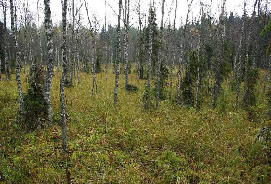
13 Spring fen vegetation


14 Spring fen vegetation: community composition Cotton-grasses: Eriophorum angustifolium E. latifolium Schoenus ferrugineus Sesleria caerulea Sedges: Carex davalliana C. hostiana C. dioica C. diandra C. rostrata Pinguicula vulgaris etc
15 Environmental factors controlling the vegetation composition High water table Low fluctuation of water table Stabile temperature Low availability of nutrients High ph Precipitation of tufa (?)
16 Water table ~ vegetation (Küttim 2013)

17 Spring fens in Koiva catchment Matsi Varstu More?

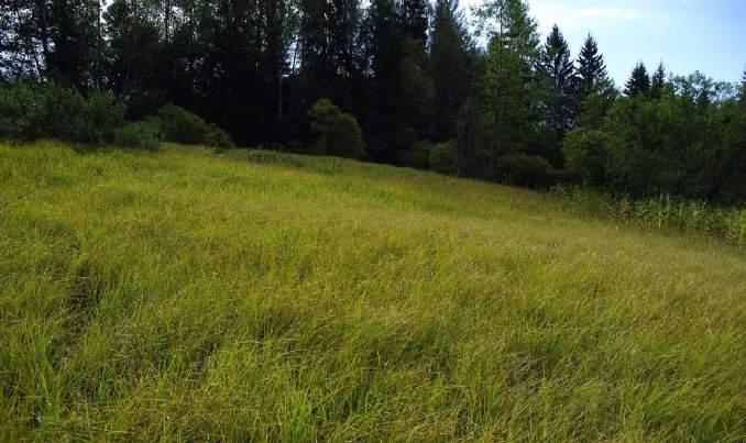
18 Matsi spring fens (Ilomets et al 2014) Location: Võru county, Varstu parish, Matsi village Geologically: in Võru-Hargla valley, by the Mustjõgi river Area: 4.6 ha (in three parts) Northern part 3.4 ha In a relatively good state, but surrounded by the ditches and a road Mostly open habitats, but wooded in drier part Vegetation: Dominated everywhere by Menyanthes trifoliata Sedges (Carex lasiocarpa, C. rostrata) Abundant Epipactis palustris (protected II cat.!)


19 Matsi spring fens (Ilomets et al 2014)

 Minor slope (1 m per 50 m) ph 6.9...7.")
20 Matsi spring fens (Ilomets et al 2014) Oppressional springs (igritsevad) in the northern and central part, overflowing water in the south Tufa precipitation in the northern and central part, iron precipitation in the south Water table near surface ( cm below surface) Minor slope (1 m per 50 m) ph Sedge-brown moss peat with tufa layers
21

22

23 Thank You!
Landscapes & Hydric Soils Bruce Vasilas University of Delaware
 Landscapes & Hydric Soils Bruce Vasilas University of Delaware Hydric soils are defined as soils that formed under conditions of saturation, flooding, or ponding long enough during the growing season to
Introduction to the Hydrogeomorphic (HGM) Classification System
 Classification System") Introduction to the Hydrogeomorphic (HGM) Classification System Objectives The Student Will be Able to: Define the 7 HGM Classes List the 3 Parameters That Define HGM Classes List the Major Water Budget
Introduction to the Hydrogeomorphic (HGM) Classification System Objectives The Student Will be Able to: Define the 7 HGM Classes List the 3 Parameters That Define HGM Classes List the Major Water Budget
Ms. A. Mormando's Class *
 8 th Grade Science Essential Standard: 8.E.1.1 Explain the structure of the hydrosphere including: Water distribution on Earth; Local river basin and water availability Stream - A stream is a body of water
Biodiversity Blueprint Overview
 Biodiversity Blueprint Overview Climate Variability Climate projections for the Glenelg Hopkins Regions suggest that the weather will be hotter and drier in the coming years which will impact on land use,
Permafrost-influenced Geomorphic Processes
 Section 4 Permafrost-influenced Geomorphic Processes Geomorphic processes vary greatly among ecoregions in northern Alaska, extending from the Beaufort Sea coast to the Brooks Range (Figure 4.1). Regional
Module 3. Basic Ecological Principles
 Module 3. Basic Ecological Principles Ecosystem Components Abiotic Biotic Species & Habitat The Biomes of North America Communities Energy & Matter Cycles in Ecosystems Primary Productivity Simple Ecosystem
Creating ponds for Marsh Clubmoss Lycopodielle inundata
 Creating ponds for Marsh Clubmoss Lycopodielle inundata Freshwater Habitats Trust 1. What is Marsh Clubmoss? Marsh Clubmoss Lycopodiella inundata is not a true moss but a primitive non-flowering plant
Origin of the Atmosphere. Note: No free oxygen at this point!!! (A) (B)
 (B)") Origin of the Atmosphere (A) During the early stages of segregation within Earth (A), gaseous materials escaped from Earth s interior. A process called volcanic outgassing An atmosphere gradually evolved,
Origin of the Atmosphere (A) During the early stages of segregation within Earth (A), gaseous materials escaped from Earth s interior. A process called volcanic outgassing An atmosphere gradually evolved,
Earth s Major Terrerstrial Biomes. *Wetlands (found all over Earth)
") Biomes Biome: the major types of terrestrial ecosystems determined primarily by climate 2 main factors: Depends on ; proximity to ocean; and air and ocean circulation patterns Similar traits of plants
Biomes Biome: the major types of terrestrial ecosystems determined primarily by climate 2 main factors: Depends on ; proximity to ocean; and air and ocean circulation patterns Similar traits of plants
How Do Human Impacts and Geomorphological Responses Vary with Spatial Scale in the Streams and Rivers of the Illinois Basin?
 How Do Human Impacts and Geomorphological Responses Vary with Spatial Scale in the Streams and Rivers of the Illinois Basin? Bruce Rhoads Department of Geography University of Illinois at Urbana-Champaign
Kakagon Sloughs, Bad River Reservation 1980s Jim Meeker, Northland College
 Natural history of coastal wetlands in the greater Chequamegon Bay region Kakagon Sloughs, Bad River Reservation 1980s Jim Meeker, Northland College small large northern Great Lake wetlands are dominated
Why Geomorphology for Fish Passage
 Channel Morphology - Stream Crossing Interactions An Overview Michael Love Michael Love & Associates mlove@h2odesigns.com (707) 476-8938 Why Geomorphology for Fish Passage 1. Understand the Scale of the
GIS and Coastal Nutrients Luke Cole
 GIS and Coastal Nutrients Luke Cole Human population density has been widely utilized as a valid predictor of terrestrial nitrogen loads into marine systems. As 50% of the world s population lives within
Surface Water Short Study Guide
 Name: Class: Date: Surface Water Short Study Guide Multiple Choice Identify the letter of the choice that best completes the statement or answers the question. 1. The three ways in which a stream carries
WATER ON AND UNDER GROUND. Objectives. The Hydrologic Cycle
 WATER ON AND UNDER GROUND Objectives Define and describe the hydrologic cycle. Identify the basic characteristics of streams. Define drainage basin. Describe how floods occur and what factors may make
Consulting Services (Pty.) Ltd.
 Ltd.") Wetland Consulting Services (Pty.) Ltd. 98/726/07 P.O. Box 72295 Lynnwood Ridge Pretoria 0040 Consulting Services (Pty.) Ltd. Specialist wetland and riparian consultants Room S 57 Building 33 CSIR Meiring
Wetland Consulting Services (Pty.) Ltd. 98/726/07 P.O. Box 72295 Lynnwood Ridge Pretoria 0040 Consulting Services (Pty.) Ltd. Specialist wetland and riparian consultants Room S 57 Building 33 CSIR Meiring
Subtidal permanently flooded with tidal water. Irregularly exposed surface exposed by tides less often than daily
 Types of Wetlands Tidal Systems COASTAL WETLAND ECOSYSTEMS Tidal Salt Marshes Tidal Freshwater Marshes Mangrove Wetlands Tidal Estuarine Wetland 1 Definition and Formation of Estuaries u Estuary : partially
Types of Wetlands. Tidal Systems
 Types of Wetlands Tidal Systems 1 COASTAL WETLAND ECOSYSTEMS Tidal Salt Marshes Tidal Freshwater Marshes Mangrove Wetlands 2 Tidal Estuarine Wetland 3 Definition and Formation of Estuaries Estuary: : partially
Wetland and Riparian Mapping: An Overview of the Montana Program
 Wetland and Riparian Mapping: An Overview of the Montana Program Meghan Burns, Catherine McIntyre, Karen Newlon Ecology Program Montana Natural Heritage Program Helena, MT Montana Natural Heritage Program
Wetland & Floodplain Functional Assessments and Mapping To Protect and Restore Riverine Systems in Vermont. Mike Kline and Laura Lapierre Vermont DEC
 Wetland & Floodplain Functional Assessments and Mapping To Protect and Restore Riverine Systems in Vermont Mike Kline and Laura Lapierre Vermont DEC NWI+ Hydro-Geomorphic Characterization of Wetlands and
ADDRESSING GEOMORPHIC AND HYDRAULIC CONTROLS IN OFF-CHANNEL HABITAT DESIGN
 ADDRESSING GEOMORPHIC AND HYDRAULIC CONTROLS IN OFF-CHANNEL HABITAT DESIGN Conor Shea - Hydrologist U.S. Fish and Wildlife Service Conservation Partnerships Program Arcata, CA Learning Objectives Examine
Aquifer an underground zone or layer of sand, gravel, or porous rock that is saturated with water.
 Aggradation raising of the streambed by deposition that occurs when the energy of the water flowing through a stream reach is insufficient to transport sediment conveyed from upstream. Alluvium a general
CR AAO Bridge. Dead River Flood & Natural Channel Design. Mitch Koetje Water Resources Division UP District
 CR AAO Bridge Dead River Flood & Natural Channel Design Mitch Koetje Water Resources Division UP District Old County Road AAO Bridge Map courtesy of Marquette County Silver Lake Basin McClure Basin
Opportunities to Improve Ecological Functions of Floodplains and Reduce Flood Risk along Major Rivers in the Puget Sound Basin
 Opportunities to Improve Ecological Functions of Floodplains and Reduce Flood Risk along Major Rivers in the Puget Sound Basin Christopher Konrad, US Geological Survey Tim Beechie, NOAA Fisheries Managing
Science EOG Review: Landforms
 Mathematician Science EOG Review: Landforms Vocabulary Definition Term canyon deep, large, V- shaped valley formed by a river over millions of years of erosion; sometimes called gorges (example: Linville
The River Restoration Centre therrc.co.uk. Understanding Fluvial Processes: supporting River Restoration. Dr Jenny Mant
 The River Restoration Centre therrc.co.uk Understanding Fluvial Processes: supporting River Restoration Dr Jenny Mant Jenny@therrc.co.uk Understanding your catchment Hydrology Energy associated with the
UK Flooding Feb 2003
 UK Flooding 2000 06 Feb 2003 Britain has taken a battering from floods in the last 5 years, with major events in 1998 and 2000, significant floods in 2001 and minor events in each of the other years. So
Natural Shoreline Landscapes on Michigan Inland Lakes
 Natural Shoreline Landscapes on Michigan Inland Lakes Excerpts from Chapters 2 and 3 Photo Photo by Jane by Jane Herbert Herbert Did you know? Twenty-four species of amphibians, 25 species of reptiles,
AQUATIC RESOURCES DELINEATION REFRESHER
 AQUATIC RESOURCES DELINEATION REFRESHER James Jamie Robb Wetland Specialist, Office of the Chief 12 October 2016 US Army Corps of Engineers Ordinary High Water Mark (OHWM) How is the OHWM characterized
Surface Processes Focus on Mass Wasting (Chapter 10)
") Surface Processes Focus on Mass Wasting (Chapter 10) 1. What is the distinction between weathering, mass wasting, and erosion? 2. What is the controlling force in mass wasting? What force provides resistance?
Surface Processes Focus on Mass Wasting (Chapter 10) 1. What is the distinction between weathering, mass wasting, and erosion? 2. What is the controlling force in mass wasting? What force provides resistance?
Favourable Condition of Blanket Bog on Peak District SSSIs. Richard Pollitt Lead Adviser, Conservation & Land Management, Dark and South West Peak
 Favourable Condition of Blanket Bog on Peak District SSSIs Richard Pollitt Lead Adviser, Conservation & Land Management, Dark and South West Peak Definitions SSSI Site of Special Scientific Interest statutory
Wetlands and Riparian Mapping Framework Technical Meeting
 Wetlands and Riparian Mapping Framework Technical Meeting Meghan Burns Landscape Ecologist Linda Vance Senior Ecologist Why wetland and riparian mapping? Preliminary site assessment for the presence of
Review of Riparian Function Riparian Management Riparian Monitoring
 Review of Riparian Function Riparian Management Riparian Monitoring Water Shed Water Catchment Water catching creek Water shedding creek Properly functioning riparian area Properly Functioning Riparian
Wisconsin s Hydrogeology: an overview
 2012 Soil and Water Conservation Society Conference Stevens Point, WI Feb 9, 2012 Wisconsin s Hydrogeology: an overview Ken Bradbury Wisconsin Geological and Natural History Survey University of Wisconsin-Extension
CHAPTER 6 & 7 VOCABULARY
 CHAPTER 6 & 7 VOCABULARY 1. Biome 2. Climate 3. Latitude 4. Altitude 5. Emergent layer 6. Epiphyte 7. Understory 8. Permafrost 9. Wetland 10.Plankton 11.Nekton 12.Benthos 13.Littoral zone 14.Benthic zone
Permafrost & climate change in northern Finland Dr Steve Gurney
 Permafrost & climate change in northern Finland Dr Steve Gurney Senior Lecturer in Geomorphology University of Reading, UK Docent in cold climate geomorphology University of Turku, Finland Topics Introduction
Representative Reference Area Akehurst, Venner meadow, Burnette lake, Fork meadow, paradise meadow, Rimrock swamp, Goose Carex,
 Description This mixed sedge wetland community is the most common wetland type in BC s interior rangelands. These sedge species are able to tolerate anaerobic soil conditions for the entire growing season.
A Help Guide for Using gssurgo to Find Potential Wetland Soil Landscapes
 A Help Guide for Using gssurgo to Find Potential Wetland Soil Landscapes Wetland Mapping Consortium Webinar September 17, 2014 Dr. John M. Galbraith Crop & Soil Environmental Sciences Virginia Tech Wetland
Haiti and Dominican Republic Flash Flood Initial Planning Meeting
 Dr Rochelle Graham Climate Scientist Haiti and Dominican Republic Flash Flood Initial Planning Meeting September 7 th to 9 th, 2016 Hydrologic Research Center http://www.hrcwater.org Haiti and Dominican
Directed Reading. Section: Types of Maps
 Skills Worksheet Directed Reading Section: Types of Maps 1. What are some of the characteristics of an area shown on maps used by Earth scientists? a. types of animals, types of plants, types of minerals
Chiang Rai Province CC Threat overview AAS1109 Mekong ARCC
 Chiang Rai Province CC Threat overview AAS1109 Mekong ARCC This threat overview relies on projections of future climate change in the Mekong Basin for the period 2045-2069 compared to a baseline of 1980-2005.
27. Running Water I (p ; )
") 27. Running Water I (p. 424-436; 440-444) Hydrosphere How much of the Earth s surface is covered by water? Earth's water is collectively called the and is stored in a number of so-called as follows: 1.
27. Running Water I (p. 424-436; 440-444) Hydrosphere How much of the Earth s surface is covered by water? Earth's water is collectively called the and is stored in a number of so-called as follows: 1.
Chapter 52 An Introduction to Ecology and the Biosphere
 Chapter 52 An Introduction to Ecology and the Biosphere Ecology The study of the interactions between organisms and their environment. Ecology Integrates all areas of biological research and informs environmental
Fresh Water: Streams, Lakes Groundwater & Wetlands
 Fresh Water:, Lakes Groundwater & Wetlands Oct 27 Glaciers and Ice Ages Chp 13 Nov 3 Deserts and Wind and EXAM #3 Slope hydrologic cycle P = precip I = precip intercepted by veg ET = evapotranspiration
Overview of fluvial and geotechnical processes for TMDL assessment
 Overview of fluvial and geotechnical processes for TMDL assessment Christian F Lenhart, Assistant Prof, MSU Research Assoc., U of M Biosystems Engineering Fluvial processes in a glaciated landscape Martin
Lower South Fork McKenzie River Floodplain Enhancement Project
 Lower South Fork McKenzie River Floodplain Enhancement Project McKenzie River Ranger District Willamette National Forest Project Location The project is located in the South Fork McKenzie River Watershed,
Sun, Moon, Hydrosphere Worksheet - Answers
 Sun, Moon, Hydrosphere Worksheet - Answers Question 1 WHAT TERM CORRESPONDS TO EACH OF THE FOLLOWING DEFINITIONS? a) a landform, slope or terrain that can affect water circulation b) the Earth s blue envelope
Ecosystems Chapter 4. What is an Ecosystem? Section 4-1
 Ecosystems Chapter 4 What is an Ecosystem? Section 4-1 Ecosystems Key Idea: An ecosystem includes a community of organisms and their physical environment. A community is a group of various species that
Appendix E: Cowardin Classification Coding System
 Appendix E: Cowardin Classification Coding System The following summarizes the Cowardin classification coding system and the letters and numbers used to define the USFWS NWI wetland types and subtypes:
STUDY GUIDE FOR CONTENT MASTERY. Surface Water Movement
 Surface Water SECTION 9.1 Surface Water Movement In your textbook, read about surface water and the way in which it moves sediment. Complete each statement. 1. An excessive amount of water flowing downslope
Geog Lecture 19
 Geog 1000 - Lecture 19 Fluvial Geomorphology and River Systems http://scholar.ulethbridge.ca/chasmer/classes/ Today s Lecture (Pgs 346 355) 1. What is Fluvial Geomorphology? 2. Hydrology and the Water
Fluvial Systems Lab Environmental Geology Lab Dr. Johnson
 Fluvial Systems Lab Environmental Geology Lab Dr. Johnson *Introductory sections of this lab were adapted from Pidwirny, M. (2006). "Streamflow and Fluvial Processes". Fundamentals of Physical Geography,
Developing a Landscape-Level Reference Standard Wetland Profile for the Prairie Pothole Region, Montana
 Developing a Landscape-Level Reference Standard Wetland Profile for the Prairie Pothole Region, Montana Prepared for: The U.S. Environmental Protection Agency Prepared by: Melissa Hart and Linda Vance
6.1 Water. The Water Cycle
 6.1 Water The Water Cycle Water constantly moves among the oceans, the atmosphere, the solid Earth, and the biosphere. This unending circulation of Earth s water supply is the water cycle. The Water Cycle
Rivers T. Perron
 1 Rivers T. Perron 12.001 After our discussions of large-scale topography, how we represent topography in maps, and how topography interacts with geologic structures, you should be frothing at the mouth
In the space provided, write the letter of the description that best matches the term or phrase. a. any form of water that falls to Earth s
 Skills Worksheet Concept Review In the space provided, write the letter of the description that best matches the term or phrase. 1. condensation 2. floodplain 3. watershed 4. tributary 5. evapotranspiration
Thank you to all of our 2015 sponsors: Media Partner
 Thank you to all of our 2015 sponsors: Media Partner Fluvial System Concepts and Their Application in Greenfield Stream Corridor Realignment Dr. Paul Villard, P.Geo. GEO Morphix Ltd. Overview Major realignment
Simulating the groundwater discharge to wetlands. Mukwonago Basin Example and Potential Application in Dane County
 Simulating the groundwater discharge to wetlands Mukwonago Basin Example and Potential Application in Dane County Conceptual Model Topography is major control on flow to wetlands Land Surface Water Table
Karr J.R. and D.R. Dudley Ecological perspective on water quality goals. Environmental Manager 5:55-68.
 Ecological Integrity Assessment: An Approach for Assessing Ecosystem Condition to Guide Conservation and Management Ecological Integrity " the ability of an ecosystem to support and maintain i a balanced
Wetlands in a Watershed/Landscape Context Vegetation & Wildlife August 15, Kendra Moseley, Regional ESS, Soil Science Division
 Wetlands in a Watershed/Landscape Context Vegetation & Wildlife August 15, 2018 - Kendra Moseley, Regional ESS, Soil Science Division Vegetation in Wetlands Vegetation as an Indicator of Hydrology Vegetation
Imaging Critical Zone Processes
 Imaging Critical Zone Processes Kamini Singha Hydrologic Science and Engineering Colorado School of Mines With contributions from: Xavier Comas, Jorden Hayes, and Andy Parsekian Key critical zone processes
 12 10 8 6 4 2 0 40-50 50-60 60-70 70-80 80-90 90-100 Fresh Water What we will cover The Hydrologic Cycle River systems Floods Groundwater Caves and Karst Topography Hot springs Distribution of water in
VEGETATION EVA BOEHRINGER
 VEGETATION EVA BOEHRINGER April 2, 2014 WUP CONSULTATIVE COMMITTEE WUP Consultative Committee (WUP CC) recognized that riparian and wetland vegetation in the reservoir drawdown zone is valuable for fish,
Distinct landscape features with important biologic, hydrologic, geomorphic, and biogeochemical functions.
 1 Distinct landscape features with important biologic, hydrologic, geomorphic, and biogeochemical functions. Have distinguishing characteristics that include low slopes, well drained soils, intermittent
2. Irrigation. Key words: right amount at right time What if it s too little too late? Too much too often?
 2. Irrigation Key words: right amount at right time What if it s too little too late? 2-1 Too much too often? To determine the timing and amount of irrigation, we need to calculate soil water balance.
STREAM SYSTEMS and FLOODS
 STREAM SYSTEMS and FLOODS The Hydrologic Cycle Precipitation Evaporation Infiltration Runoff Transpiration Earth s Water and the Hydrologic Cycle The Hydrologic Cycle The Hydrologic Cycle Oceans not filling
Precipitation Evaporation Infiltration Earth s Water and the Hydrologic Cycle. Runoff Transpiration
 STREAM SYSTEMS and FLOODS The Hydrologic Cycle Precipitation Evaporation Infiltration Earth s Water and the Hydrologic Cycle Runoff Transpiration The Hydrologic Cycle The Hydrologic Cycle Oceans not filling
Lecture 29: Soil Formation
 Lecture 29: Soil Formation Factors Controlling Soil Formation 1. Parent material: Soil precursor 2. Climate: Temperature and precipitation 3. Biota: Native vegetation, microbes, soil animals, humans 4.
Crows Landing Naval Base Easement
 1 of 15 West Stanislaus Resource Conservation District Crows Landing Naval Base Easement Annual Reserve Monitoring Report Jamie McFarlin 11/112012 2 of 15 West Stanislaus Resource Conservation District
Marl Prairie vegetation response to 20th century land use and its implications for management in the Everglades
 Marl Prairie vegetation response to 20th century land use and its implications for management in the Everglades C. Bernhardt, D. Willard, B. Landacre US Geological Survey Reston, VA USA U.S. Department
Catastrophic Events Impact on Ecosystems
 Catastrophic Events Impact on Ecosystems Hurricanes Hurricanes An intense, rotating oceanic weather system with sustained winds of at least 74 mph and a welldefined eye Conditions for formation: Warm water
A hydrological study of Waen y Griafolen blanket bog, North Wales
 A hydrological study of Waen y Griafolen blanket bog, North Wales GRAHAM HALL, ROGER CRATCHLEY & SARAH JOHNSON Centre for Arid Zone Studies, School of Agricultural and Forest Sciences, University of Wales,
Ecology 312 SI STEVEN F. Last Session: Aquatic Biomes, Review This Session: Plate Tectonics, Lecture Quiz 2
 Ecology 312 SI STEVEN F. Last Session: Aquatic Biomes, Review This Session: Plate Tectonics, Lecture Quiz 2 Questions? Warm up: KWL KNOW: On a piece of paper, write down things that you know well enough
Influence of the Major Drainages to the Mississippi River and Implications for System Level Management
 Influence of the Major Drainages to the Mississippi River and Implications for System Level Management Brian M. Vosburg Geologist Louisiana Coastal Protection and Restoration Authority brian.vosburg@la.gov
Bright blue marble floating in space. Biomes & Ecology
 Bright blue marble floating in space Biomes & Ecology Chapter 50 Spheres of life Molecules Cells (Tissues Organ Organ systems) Organisms Populations Community all the organisms of all the species that
The Effect of Weather, Erosion, and Deposition in Texas Ecoregions
 The Effect of Weather, Erosion, and Deposition in Texas Ecoregions 7.8B: I can analyze the effects of weathering, erosion, and deposition on the environment in ecoregions of Texas Weathering The breakdown
SAN FRANCISCO DISTRICT INFORMATION REQUESTED FOR VERIFICATION OF CORPS JURISDICTION
 DEPARTMENT OF THE ARMY SAN FRANCISCO DISTRICT, U.S. ARMY CORPS OF ENGINEERS 1455 MARKET STREET SAN FRANCISCO, CALIFORNIA 94103-1398 SAN FRANCISCO DISTRICT INFORMATION REQUESTED FOR VERIFICATION OF CORPS
Year 6. Geography. Revision
 Year 6 Geography Revision November 2017 Rivers and World knowledge How the water cycle works and the meaning of the terms evaporation, condensation, precipitation, transpiration, surface run-off, groundwater
National Atlas of Groundwater Dependent Ecosystems (GDE)
") National Atlas of Groundwater Dependent Ecosystems (GDE) Dr. Zaffar Sadiq Mohamed-Ghouse Executive Consultant & Practice Head-Spatial SKM, Australia zsadiq@globalskm.com Geospatial World Forum 2013, Rotterdam,
National Atlas of Groundwater Dependent Ecosystems (GDE) Dr. Zaffar Sadiq Mohamed-Ghouse Executive Consultant & Practice Head-Spatial SKM, Australia zsadiq@globalskm.com Geospatial World Forum 2013, Rotterdam,
UNIT 5: ECOLOGY Chapter 15: The Biosphere
 CORNELL NOTES Directions: You must create a minimum of 5 questions in this column per page (average). Use these to study your notes and prepare for tests and quizzes. Notes will be stamped after each assigned
Factors influencing nutrient and sediment retention by riverine wetlands in the Chesapeake watershed Greg Noe, Cliff Hupp, Ed Schenk, Nancy Rybicki
 Factors influencing nutrient and sediment retention by riverine wetlands in the Chesapeake watershed Greg Noe, Cliff Hupp, Ed Schenk, Nancy Rybicki National Research Program, Reston VA U.S. Department
RANGE AND ANIMAL SCIENCES AND RESOURCES MANAGEMENT - Vol. II - Catchment Management A Framework for Managing Rangelands - Hugh Milner
 CATCHMENT MANAGEMENT A FRAMEWORK FOR MANAGING RANGELANDS Hugh Milner International Water Management Consultant, Australia Keywords: Rangeland management; catchments and watersheds; catchment management
Ecoregions Glossary. 7.8B: Changes To Texas Land Earth and Space
 Ecoregions Glossary Ecoregions The term ecoregions was developed by combining the terms ecology and region. Ecology is the study of the interrelationship of organisms and their environments. The term,
What is a water table? What is an aquifer? What is the difference between a spring and a well?
 CHAPTER 11 3 Water Underground SECTION The Flow of Fresh Water BEFORE YOU READ After you read this section, you should be able to answer these questions: What is a water table? What is an aquifer? What
2012 Rainfall, Runoff, Water Level & Temperature Beebe Lake Wright County, MN (# )
") www.fixmylake.com 18029 83 rd Avenue North Maple Grove, MN 55311 mail@freshwatersci.com (651) 336-8696 2012 Rainfall, Runoff, Water Level & Temperature Beebe Lake Wright County, MN (#86-0023) Prepared
www.fixmylake.com 18029 83 rd Avenue North Maple Grove, MN 55311 mail@freshwatersci.com (651) 336-8696 2012 Rainfall, Runoff, Water Level & Temperature Beebe Lake Wright County, MN (#86-0023) Prepared
3.11 Floodplains Existing Conditions
 Other stormwater control practices may be needed to mitigate water quality impacts. In addition to detention facilities, other practices such as vegetated basins/buffers, infiltration basins, and bioswales
3/3/2013. The hydro cycle water returns from the sea. All "toilet to tap." Introduction to Environmental Geology, 5e
 Introduction to Environmental Geology, 5e Running Water: summary in haiku form Edward A. Keller Chapter 9 Rivers and Flooding Lecture Presentation prepared by X. Mara Chen, Salisbury University The hydro
How to integrate wetland processes in river basin modeling? A West African case study
 How to integrate wetland processes in river basin modeling? A West African case study stefan.liersch@pik-potsdam.de fred.hattermann@pik-potsdam.de June 2011 Outline Why is an inundation module required?
SUPPLEMENTARY MATERIAL
 1 2 3 4 5 6 7 8 9 10 11 12 13 14 15 16 17 18 19 20 SUPPLEMENTARY MATERIAL Hoset KS, Ruffino L, Tuomi M, Oksanen T, Oksanen L, Mäkynen A, Johansen B and Moe T. Changes in the spatial configuration and strength
Which map shows the stream drainage pattern that most likely formed on the surface of this volcano? A) B)
 B)") 1. When snow cover on the land melts, the water will most likely become surface runoff if the land surface is A) frozen B) porous C) grass covered D) unconsolidated gravel Base your answers to questions
1. When snow cover on the land melts, the water will most likely become surface runoff if the land surface is A) frozen B) porous C) grass covered D) unconsolidated gravel Base your answers to questions
SESSION 6: FLUVIAL LANDFORMS
 SESSION 6: FLUVIAL LANDFORMS KEY CONCEPTS: Fluvial Landforms Management of River Catchment Areas Slope Elements X-PLANATION: FLUVIAL LANDFORMS Rivers form landforms as they erode the landscape. These landforms
Ecology. Ecology terminology Biomes Succession Energy flow in ecosystems Loss of energy in a food chain
 Ecology Ecology terminology Biomes Succession Energy flow in ecosystems Loss of energy in a food chain Terminology Ecology- the study of the interactions of living organisms with one another and with their
12 SWAT USER S MANUAL, VERSION 98.1
 12 SWAT USER S MANUAL, VERSION 98.1 CANOPY STORAGE. Canopy storage is the water intercepted by vegetative surfaces (the canopy) where it is held and made available for evaporation. When using the curve
Observations on Surface Water in the Seminary Fen in Spring, Prepared 6/4/13 by Sam Wetterlin; updated 7/28/13
 Observations on Surface Water in the Seminary Fen in Spring, 2013 Prepared 6/4/13 by Sam Wetterlin; updated 7/28/13 Ordinarily, a calcareous fen is primarily dependent on upwelling mineral-rich, oxygen-poor
Chapter 7 Part III: Biomes
 Chapter 7 Part III: Biomes Biomes Biome: the major types of terrestrial ecosystems determined primarily by climate 2 main factors: Temperature and precipitation Depends on latitude or altitude; proximity
Environmental Science
 Environmental Science A Study of Interrelationships Cui Jiansheng Hebei University of Science and Technology CH06 Kinds of Ecosystems and Communities Chapter Objectives After reading this chapter, you
Chapter 13. Groundwater
 Chapter 13 Groundwater Introduction Groundwater is all subsurface water that completely fills the pores and other open spaces in rocks, sediments, and soil. Groundwater is responsible for forming beautiful
2.6.3 Forms of standing open water
 Fig. 33 Distinctive forms created by oioi restiad rushland, New River Estuary, Southland. These pikelets are elevating themselves above the level of mudflats and tidal channels as the rushes trap sediment.
Flash flood disaster in Bayangol district, Ulaanbaatar
 Flash flood disaster in Bayangol district, Ulaanbaatar Advanced Training Workshop on Reservoir Sedimentation Management 10-16 October 2007. IRTCES, Beijing China Janchivdorj.L, Institute of Geoecology,MAS
Upper Truckee River Restoration Lake Tahoe, California Presented by Brendan Belby Sacramento, California
 Upper Truckee River Restoration Lake Tahoe, California Presented by Brendan Belby Sacramento, California Mike Rudd (Project Manager), Charley Miller & Chad Krofta Declines in Tahoe s Water Clarity The