Favourable Condition of Blanket Bog on Peak District SSSIs. Richard Pollitt Lead Adviser, Conservation & Land Management, Dark and South West Peak
|
|
|
- Percival Willis
- 6 years ago
- Views:
Transcription

1 Favourable Condition of Blanket Bog on Peak District SSSIs Richard Pollitt Lead Adviser, Conservation & Land Management, Dark and South West Peak
2 Definitions SSSI Site of Special Scientific Interest statutory site, notified under UK law with legal protection for the interest features, In this case The Dark Peak SSSI The Site bit is a geographically defined space a field for instance, but here c32,000ha of bog, heath, woodland and grassland. Scientific Interest is a feature that can be described and appraised such as a hay meadow grassland, or as here numerous habitats and many species and some geodiversity Special relative status, the best in a geographic zone
3 More definitions Favourable Condition Is achieved when the targets in the conservation objectives for the condition of the feature are met Such as 6 or more indicator species will be found in 90% of representative samples across the feature Blanket Bog Blanket bog is a collective term for extensive rain fed, deep upland peatland over 40cm in depth on flat or sloping ground and the range of vegetation types it can support
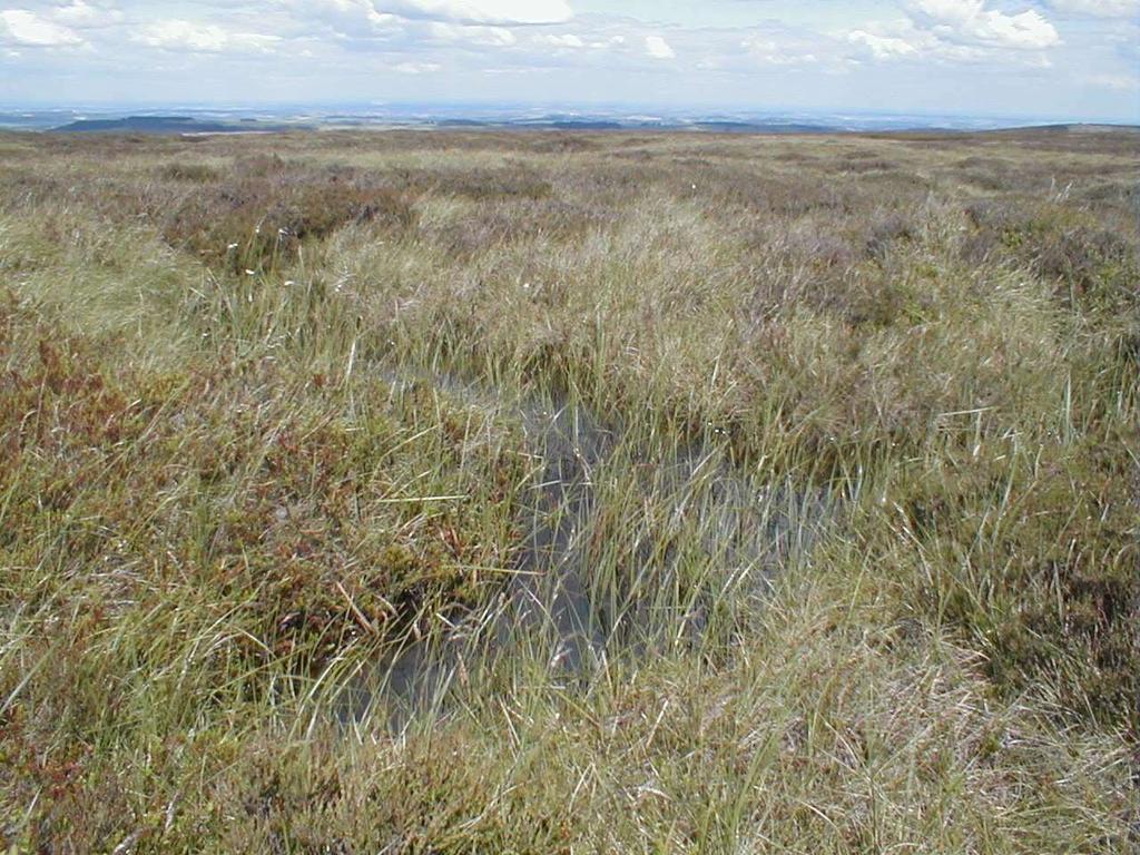
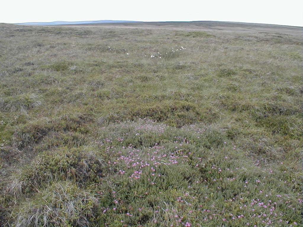
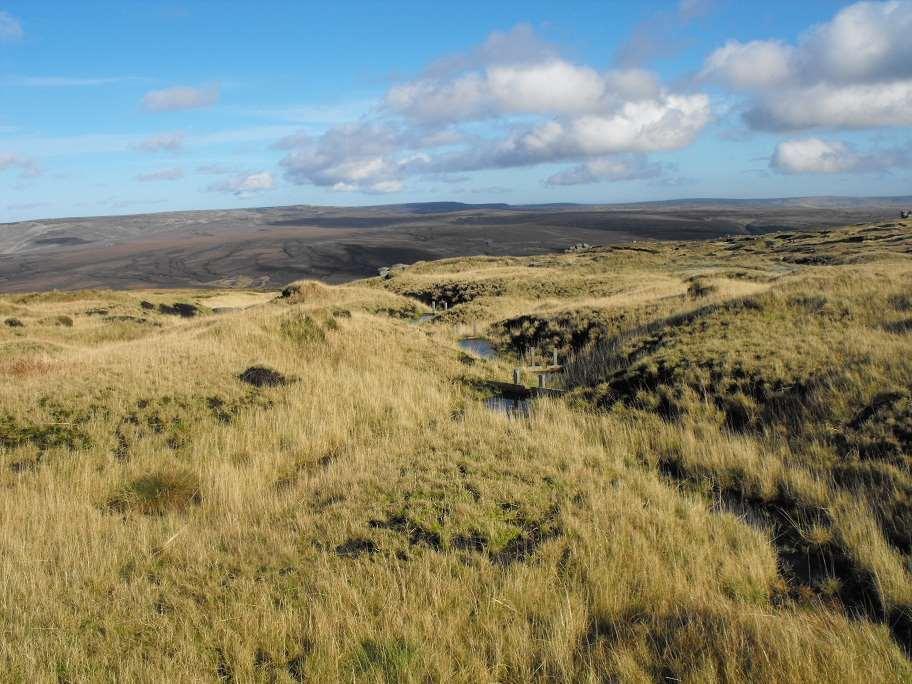
4 Designated Special Interest Feature - Bogs Bogs Active Blanket bog & valley bog (upland) Blanket bog. (Priority habitat only when active). M19b - Calluna vulgaris - Eriophorum vaginatum blanket mire, Empetrum nigrum ssp. nigrum subcommunity. Moderately diverse blanket bog. (See Audit Trail note 27). Species-poor blanket bog (intermediate between M19b/M20). M20 - Eriophorum vaginatum blanket mire. (See Audit Trail notes 4 & 24). Cotton-grass moorland. M25 Molinia caerulea Potentilla erecta mire on deep peat (> 50 cm). Molinia blanket bog. (Has an affinity to M25 mire) Depressions on peat substrates of the Rhynchosporion. M3 Eriophorum angustifolium bog pool community. Species-poor bog pools and wet hollows.
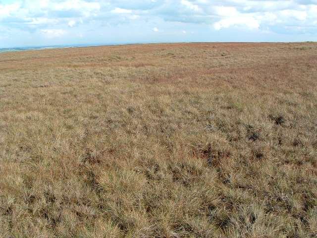
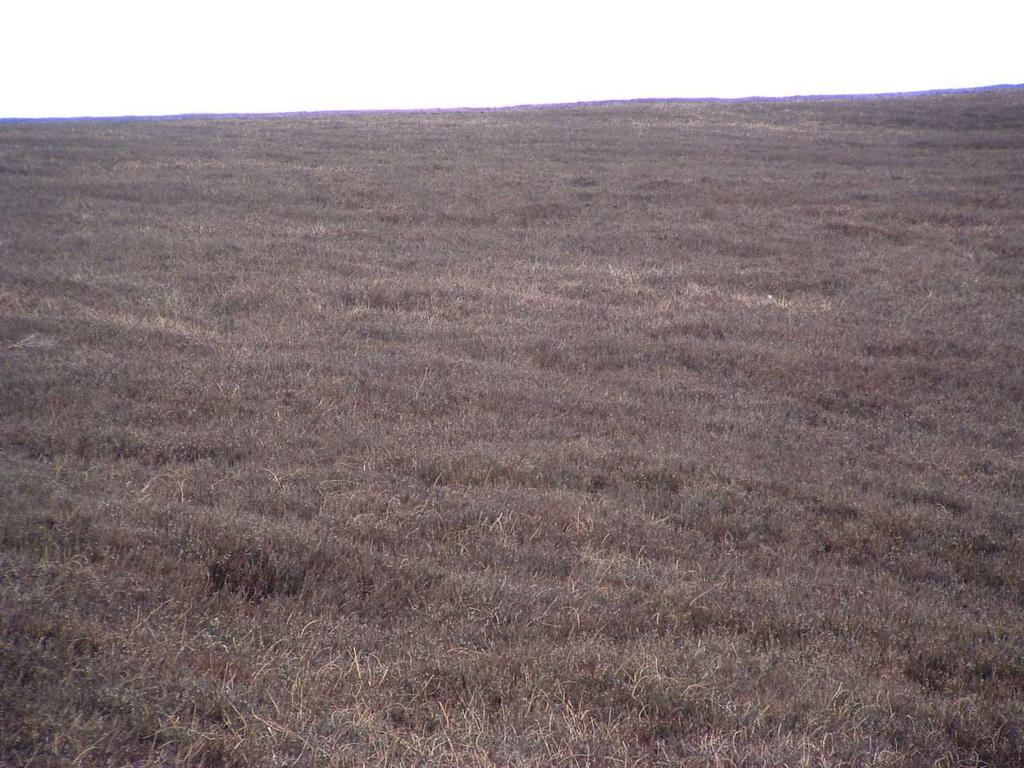
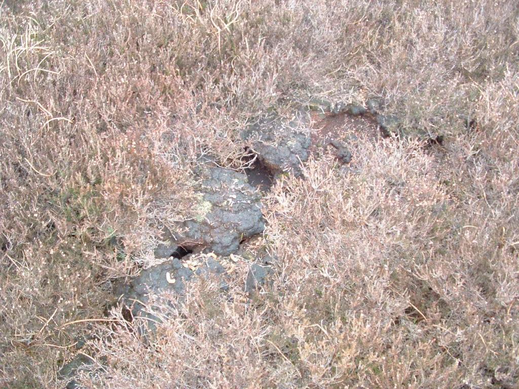
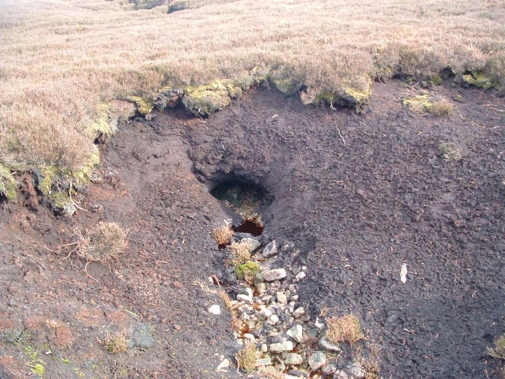
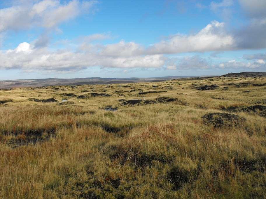
5 BLANKET BOG active. M19b moderately diverse blanket bog. Deep peat with a seasonally wet surface (but can be quite dry in summer). BLANKET BOG active Species-poor blanket bog (M19/M20) Intact or partly eroded deep peat with a variably wet surface, and occasional to frequent gullies or drains. Supports species-poor vegetation BLANKET BOG active M20 cotton-grass moorland A very widespread blanket bog vegetation type in the Dark Peak. Usually on the higher plateaus BLANKET BOG Inactive Dry blanket bog with heather. Particularly abundant on lower altitude sloping moorland plateaus, where deep deposits of dry peat are often heavily gullied BLANKET BOG Inactive Bare peat.extensive sheet erosion of peat surface on previously deep peat, resulting in the near total loss of vegetation. Maintain in actively peat-forming state. Maintain or enhance the higher plant and bryophyte flora, particularly peat-forming Sphagnum species. Protect peat resource from wildfire. Maintain / restore high water table. Increase the cover and variety of Sphagnum species. Reduce the extent of bare and eroding ground. Protect peat carbon. Maintain or enhance the higher plant and bryophyte flora, particularly peat-forming Sphagnum species. Reduce extent of bare / eroding ground. Protect peat carbon. Enhance the structural diversity of the plant cover, to include all growth stages of heather. Increase overall wetness of the feature. Protect the existing bryophyte, lichen & litter layer. Protect sensitive features and wetter areas from burning Increase overall wetness of the feature. Reduce the extent of bare and eroding ground. Return to actively peat-forming state
6
7 BLANKET BOG active. M19b moderately diverse blanket bog. Deep peat with a seasonally wet surface (but can be quite dry in summer). BLANKET BOG active Species-poor blanket bog (M19/M20) Intact or partly eroded deep peat with a variably wet surface, and occasional to frequent gullies or drains. Supports speciespoor vegetation BLANKET BOG active M20 cotton-grass moorland A very widespread blanket bog vegetation type in the Dark Peak. Usually on the higher plateaus BLANKET BOG Inactive Dry blanket bog with heather. Particularly abundant on lower altitude sloping moorland plateaus, where deep deposits of dry peat are often heavily gullied BLANKET BOG Inactive Bare peat.extensive sheet erosion of peat surface on previously deep peat, resulting in the Maintain in actively peat-forming state. Maintain or enhance the higher plant and bryophyte flora, particularly peat-forming Sphagnum species. Protect peat resource from wildfire. Maintain / restore high water table. Increase the cover and variety of Sphagnum species. Reduce the extent of bare and eroding ground. Protect peat carbon. Maintain or enhance the higher plant and bryophyte flora, particularly peat-forming Sphagnum species. Reduce extent of bare / eroding ground. Protect peat carbon. Enhance the structural diversity of the plant cover, to include all growth stages of heather. Increase overall wetness of the feature. Protect the existing bryophyte, lichen & litter layer. Protect sensitive features and wetter areas from burning Increase overall wetness of the feature. Reduce the extent of bare and eroding ground. Return to actively peat-forming state
8
9 BLANKET BOG active. M19b moderately diverse blanket bog. Deep peat with a seasonally wet surface (but can be quite dry in summer). BLANKET BOG active Species-poor blanket bog (M19/M20) Intact or partly eroded deep peat with a variably wet surface, and occasional to frequent gullies or drains. Supports species-poor vegetation BLANKET BOG active M20 cotton-grass moorland A very widespread blanket bog vegetation type in the Dark Peak. Usually on the higher plateaus BLANKET BOG Inactive Dry blanket bog with heather. Particularly abundant on lower altitude sloping moorland plateaus, where deep deposits of dry peat are often heavily gullied BLANKET BOG Inactive Bare peat.extensive sheet erosion of peat surface on previously deep peat, resulting in the near total loss of vegetation. Maintain in actively peat-forming state. Maintain or enhance the higher plant and bryophyte flora, particularly peat-forming Sphagnum species. Protect peat resource from wildfire. Maintain / restore high water table. Increase the cover and variety of Sphagnum species. Reduce the extent of bare and eroding ground. Protect peat carbon. Maintain or enhance the higher plant and bryophyte flora, particularly peat-forming Sphagnum species. Reduce extent of bare / eroding ground. Protect peat carbon. Enhance the structural diversity of the plant cover, to include all growth stages of heather. Increase overall wetness of the feature. Protect the existing bryophyte, lichen & litter layer. Protect sensitive features and wetter areas from burning Increase overall wetness of the feature. Reduce the extent of bare and eroding ground. Return to actively peat-forming state
10
11 BLANKET BOG active. M19b moderately diverse blanket bog. Deep peat with a seasonally wet surface (but can be quite dry in summer). BLANKET BOG active Species-poor blanket bog (M19/M20) Intact or partly eroded deep peat with a variably wet surface, and occasional to frequent gullies or drains. Supports species-poor vegetation BLANKET BOG active M20 cotton-grass moorland A very widespread blanket bog vegetation type in the Dark Peak. Usually on the higher plateaus BLANKET BOG Inactive Dry blanket bog with heather. Particularly abundant on lower altitude sloping moorland plateaus, where deep deposits of dry peat are often heavily gullied BLANKET BOG Inactive Bare peat.extensive sheet erosion of peat surface on previously deep peat, resulting in the near total loss of vegetation. Maintain in actively peat-forming state. Maintain or enhance the higher plant and bryophyte flora, particularly peat-forming Sphagnum species. Protect peat resource from wildfire. Maintain / restore high water table. Increase the cover and variety of Sphagnum species. Reduce the extent of bare and eroding ground. Protect peat carbon. Maintain or enhance the higher plant and bryophyte flora, particularly peat-forming Sphagnum species. Reduce extent of bare / eroding ground. Protect peat carbon. Enhance the structural diversity of the plant cover, to include all growth stages of heather. Increase overall wetness of the feature. Protect the existing bryophyte & lichen layer. Protect sensitive features and wetter areas from burning Increase overall wetness of the feature. Reduce the extent of bare and eroding ground. Return to actively peat-forming state
12
13
14
15 BLANKET BOG active. M19b moderately diverse blanket bog. Deep peat with a seasonally wet surface (but can be quite dry in summer). BLANKET BOG active Species-poor blanket bog (M19/M20) Intact or partly eroded deep peat with a variably wet surface, and occasional to frequent gullies or drains. Supports species-poor vegetation BLANKET BOG active M20 cotton-grass moorland A very widespread blanket bog vegetation type in the Dark Peak. Usually on the higher plateaus BLANKET BOG Inactive Dry blanket bog with heather. Particularly abundant on lower altitude sloping moorland plateaus, where deep deposits of dry peat are often heavily gullied BLANKET BOG Inactive Bare peat.extensive sheet erosion of peat surface on previously deep peat, resulting in the near total loss of vegetation. Maintain in actively peat-forming state. Maintain or enhance the higher plant and bryophyte flora, particularly peat-forming Sphagnum species. Protect peat resource from wildfire. Maintain / restore high water table. Increase the cover and variety of Sphagnum species. Reduce the extent of bare and eroding ground. Protect peat carbon. Maintain or enhance the higher plant and bryophyte flora, particularly peat-forming Sphagnum species. Reduce extent of bare / eroding ground. Protect peat carbon. Enhance the structural diversity of the plant cover, to include all growth stages of heather. Increase overall wetness of the feature. Protect the existing bryophyte, lichen & litter layer. Protect sensitive features and wetter areas from burning Increase overall wetness of the feature. Reduce the extent of bare and eroding ground. Return to actively peat-forming state
16
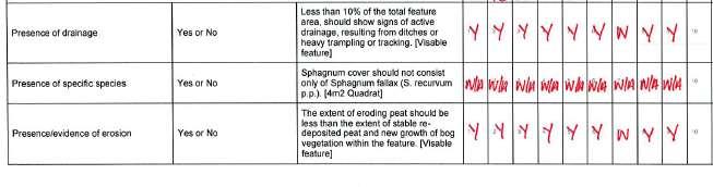
17 Notified feature (including any specific type) BLANKET BOG active M20 cotton-grass moorland Assemblage of breeding birds: Upland moorland and grassland with water bodies. Curlew Numenius arquata Dunlin Calidris alpine Golden Plover Pluvialis apricaria Merlin Falco columbarius. Peregrine Falco peregrinus. Short-eared owl Asio flammeus Cloudberry Rubus chamaemorus Bog rosemary Andromeda polifolia Labrador tea Ledum palustre See Audit Trail notes 1, 2, 4, 6 & 15 Description Objectives Management Attributes used for condition assessment 1. Maintain in actively peat-forming 1. Reduce grazing intensity (for CSM upland bird assemblage. state. maintenance) typically to about 2. Maintain or enhance the higher 0.5 ewes / ha, or lower in winter. CSM blanket bog modified plant and bryophyte flora, Determined on a unit-by-unit form. particularly peat-forming basis. Note that achieving these Sphagnum species. 3. Reduce extent of bare / eroding 2. Develop a fire plan, to safeguard interim targets indicates ground. against wildfire. unfavourable recovering not 4. Protect peat carbon. 3. Carry out targeted blocking and favourable condition. 5. Protect peat resource from damming in headwater gullies, wildfire. grips and drains. 6. Maintain or enhance breeding 4. Undertake re-vegetation in areas and feeding habitat for upland where bare peat is a prominent breeding bird assemblage and feature. In the short term this individual notified upland may involve a non-bog nurse breeding bird species. crop, but the long term aim will 7. Maintain / restore high water be to restore typical bog table. vegetation. 8. Increase the cover and variety of Sphagnum species. 5. Consider constructing sediment 9. Increase the cover of Erica traps in larger gullies. tetralix. 6. Consider seeding Erica tetralix 10. Maintain presence of cloudberry and other appropriate dwarf in units where it occurs, through shrubs directly into sward. (Note tailored objectives. that the outcome of conservation 11. No mandatory objectives for bog management should not lead to a rosemary, but should aim to demand for burning maintain presence in all units management). where it is known to occur. 7. Consider translocation of Sphagnum species into suitable areas. M20 Eriophorum vaginatum blanket mire. A very widespread blanket bog vegetation type in the Dark Peak. Usually on the higher plateaus with a very wet surface (wet or damp in summer) and scattered pools, and often associated with fairly intact or only partly eroded deep peat. It supports a much impoverished blanket bog community, which is dominated almost exclusively by hare s-tail cotton-grass, but with frequent common cotton-grass, and scattered crowberry, bilberry and wavy hair-grass. Cloudberry is locally abundant, and Sphagnum extremely rare. Very rarely supports small patches of Labrador tea. Likely to be actively peat-forming. Provides breeding & feeding habitat for bird species of the upland assemblage. CSM Interim Targets providing evidence of recovery Criteria feature Blanket bog & valley bog (upland). Interim Target 1 See Audit Trail note 5 Interim Target 2 See Audit Trail note 7 Interim Target 3 See Audit Trail note 8 Attribute term in guidance Vegetation diversity. Vegetation diversity: cover of indicator species. Physical structure: indicators of active drainage and / or ground disturbance due to herbivore and human activity. 12. No mandatory objectives for Labrador tea, but should aim to maintain presence in all units where it is known to occur. Measure Site-Specific Target (relates to numbered targets on CA form) Assess by field survey using structured walk. 1) At least 4 indicator species per 4m 2. Sphagnum fallax scores as one regardless of whether other Sphagnum species are absent. Assess by field survey using structured walk. 2) At least 50% of vegetation cover should consist of at least 3 indicator species. Assess by field survey using structured walk. Sphagnum cover may consist only of S. fallax. Eriophorum vaginatum or Calluna vulgaris can exceed 75% of the vegetation cover 13) Less than 10% of the total feature area should show signs of drainage, resulting from ditches or heavy trampling or tracking. A sample point should pass if there is evidence of gully or grip blocking at or on route to a stop. Comments This is an interim target, and should be reassessed after 6 years. Assessed at 4m 2. This is an interim target, and should be reassessed after 6 years. Assessed against visual estimate for as much of the feature as is visible while standing at a sample location, and also on route between sample stops. Assume a typical moor grip affects a strip of vegetation totalling 10m wide. Assume failure if any doubt about the cause of active drainage. This is an interim target, and should Variations from CSM See interim targets below Yes. Yes. Yes. Use for CA?
18 Feature Sub-type cotton-grass moorland M20 Eriophorum vaginatum blanket mire. A very widespread blanket bog vegetation type in the Dark Peak. Usually on the higher plateaus with a very wet surface (wet or damp in summer) and scattered pools, and often associated with fairly intact or only partly eroded deep peat. It supports a much impoverished blanket bog community, which is dominated almost exclusively by hare s-tail cotton-grass, but with frequent common cotton-grass, and scattered crowberry, bilberry and wavy hair-grass.
19 Objectives Maintain in actively peat-forming state. Maintain or enhance the higher plant and bryophyte flora, particularly peat-forming Sphagnum species. Reduce extent of bare / eroding ground. Protect peat carbon. Protect peat resource from wildfire. Maintain or enhance breeding and feeding habitat for upland breeding bird assemblage and individual notified upland breeding bird species. Maintain / restore high water table. Increase the cover and variety of Sphagnum species. Increase the cover of Erica tetralix.
20 Management Reduce grazing intensity (for maintenance) typically to about 0.5 ewes / ha, or lower in winter. Develop a fire plan, to safeguard against wildfire. Carry out targeted blocking and damming in headwater gullies, grips and drains. Undertake re-vegetation in areas where bare peat is a prominent feature. In the short term this may involve a non-bog nurse crop, but the long term aim will be to restore typical bog vegetation. Consider constructing sediment traps in larger gullies. Consider seeding Erica tetralix and other appropriate dwarf shrubs directly into sward. (Note that the outcome of conservation management should not lead to a demand for burning management). Consider translocation of Sphagnum species into suitable areas
21 How do we decide if a feature is in favourable or unfavourable state? For each interest feature a small number of attributes have been chosen that describe its condition, and targets are set for each attribute. Attributes must be quantifiable and measurable. Habitat attributes may include extent, floristic composition, vegetation structure, and physical characteristics. It is desirable for the same suite of attributes to be used for each interest feature across the UK. Assessment of condition is against pre-set targets for the feature on that site. Favourable condition is defined by setting broad targets for each attribute of the interest feature. Targets should describe the desired state of an interest feature. Targets should reflect geographical variation and local distinctiveness - they will often be influenced by site-specific factors.
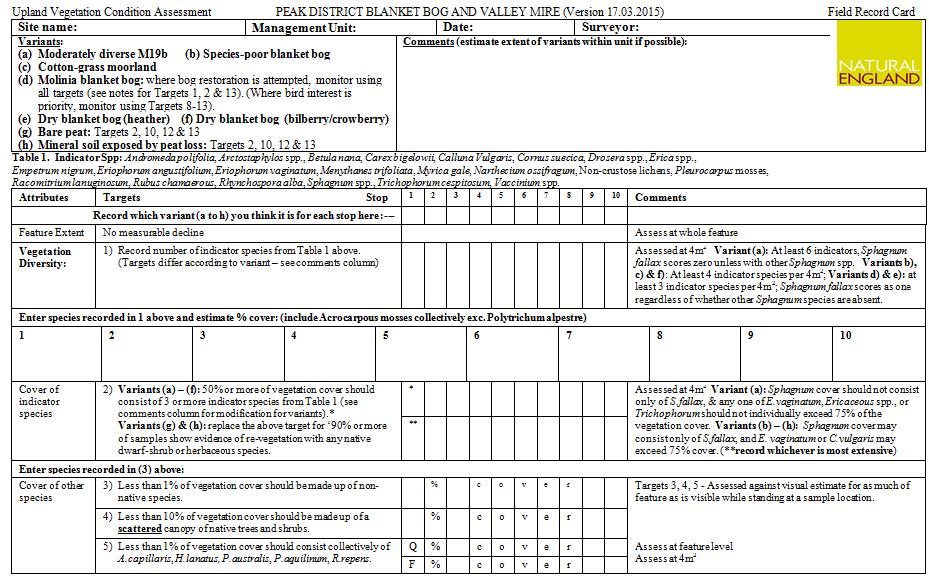
22 Common Standards for Monitoring Blanket Bog Attribute Extent of feature Vegetation indicator species Vegetation cover of indicators Vegetation other species Vegetation effects of grazing Vegetation - disturbance Physical structure peat erosion Physical structure - drainage Physical structure - disturbance Target No loss At least 6 indicator species (i.sp.) present At least 50% comprise at least 3 i.sp. No single i.sp > 75% cover <1% non-native, <10% scattered scrub/trees, <1% selected invasives <33% shoots browsed No sign of burning into peat/moss/lichen Deposition/regrowth > erosion/loss <10% damaged through drainage Trampling or tracking
23

24

25
26

27 Patricia Rice, Natural England
28

29
30
Permafrost & climate change in northern Finland Dr Steve Gurney
 Permafrost & climate change in northern Finland Dr Steve Gurney Senior Lecturer in Geomorphology University of Reading, UK Docent in cold climate geomorphology University of Turku, Finland Topics Introduction
BLANKET BOG. Outcomes and improvements LAND MANAGEMENT GUIDANCE
 BLANKET BOG Outcomes and improvements LAND MANAGEMENT GUIDANCE 3 3 4 7 11 15 19 23 CONTENTS Introduction How to use this pack Blanket bog toolkit State 2: Bare Peat State 3: Dwarf shrub dominated blanket
RESTORING ACTIVE BLANKET BOG IN IRELAND Project reference: LIFE02NAT/IRL/8490
 Page 1 of 34 RESTORING ACTIVE BLANKET BOG IN IRELAND Project reference: LIFE02NAT/IRL/8490 A REPORT ON THE RESTORATION OF PROJECT SITE No. 13. CROAGHONAGH, CO. DONEGAL. Compiled by: John Conaghan 11 Dun
Classification. Classification is the ordering of organisms into groups on the basis of their relationships. The groups are known as Taxon s.
 Classification What is classification? Classification is the ordering of organisms into groups on the basis of their relationships. The groups are known as Taxon s. Why do we classify? Biologists classify
RHOSYDD LLANPUMSAINT SITE OF SPECIAL SCIENTIFIC INTEREST
 RHOSYDD LLANPUMSAINT SITE OF SPECIAL SCIENTIFIC INTEREST Sam Bosanquet 2008 YOUR SPECIAL SITE AND ITS FUTURE Your Special Site and its Future is part of our commitment to improve the way we work with Site
Creating ponds for Marsh Clubmoss Lycopodielle inundata
 Creating ponds for Marsh Clubmoss Lycopodielle inundata Freshwater Habitats Trust 1. What is Marsh Clubmoss? Marsh Clubmoss Lycopodiella inundata is not a true moss but a primitive non-flowering plant
Representative Reference Area Akehurst, Venner meadow, Burnette lake, Fork meadow, paradise meadow, Rimrock swamp, Goose Carex,
 Description This mixed sedge wetland community is the most common wetland type in BC s interior rangelands. These sedge species are able to tolerate anaerobic soil conditions for the entire growing season.
Bee, butterfly & hare illustrations Chris Shields Bird illustrations Mike Langman. Sphagnum survey walks
 Bee, butterfly & hare illustrations Chris Shields Bird illustrations Mike Langman Sphagnum survey walks Housekeeping Emergency Exits Fire assembly point Toilets Today s Session 1. Presentation Peak District
Dune habitat conservation status assessment review
 Annotated document key - Item Summary Emphasis Dune habitat conservation status assessment review CCW carried out an assessment of the condition of the dune habitats of the SAC in the summer of 2005 and
Sphagnum re-introduction project: A report on research into the re-introduction of Sphagnum mosses to degraded moorland
 Sphagnum re-introduction project: A report on research into the re-introduction of Sphagnum mosses to degraded moorland Moor for the Future Research Report 18 This report and the associated research was
Environmental Statement South Kyle Wind Farm August Appendix 12.9: The Habitat Loss and Disturbance Calculations
 Appendix 12.9: The Habitat and Disturbance Calculations 1.1 Introduction 1 This appendix details the approach, assumptions and results of the process adopted to quantify habitat loss and degradation as
Main Issues Report - Background Evidence 5. Site Analysis
 Main Issues Report - Background Evidence 5. Site Analysis 134 Cairngorms National Park Local Development Plan 135 Main Issues Report - Background Evidence 5. Site Analysis 136 Cairngorms National Park
Seeded Lower Grasslands
 Description Poor condition grasslands have been seeded to crested wheatgrass-alfalfa mixes throughout the southern interior. The crested wheatgrass tends to be persistent unless abused, while the alfalfa
Bolton Fell and Walton Mosses SSSI Cumbria
 Bolton Fell and Walton Mosses SSSI Cumbria Notification under section 28C of the Wildlife and Countryside Act 1981 Supporting Information Issued by Natural England s Cumbria Area Team on 13 March 2015
North Lowther Energy Initiative National Vegetation Classification Survey Report Technical Appendix 8.1
 Document Quality Record Version Status Person Responsible Date 1 Draft Brian Henry 19/09/2016 2 Reviewed Rafe Dewar 21/09/2016 3 Updated Brian Henry 21/09/2016 4 Internal Approval Brian Henry 08/03/2017
Earth s Major Terrerstrial Biomes. *Wetlands (found all over Earth)
") Biomes Biome: the major types of terrestrial ecosystems determined primarily by climate 2 main factors: Depends on ; proximity to ocean; and air and ocean circulation patterns Similar traits of plants
Biomes Biome: the major types of terrestrial ecosystems determined primarily by climate 2 main factors: Depends on ; proximity to ocean; and air and ocean circulation patterns Similar traits of plants
A hydrological study of Waen y Griafolen blanket bog, North Wales
 A hydrological study of Waen y Griafolen blanket bog, North Wales GRAHAM HALL, ROGER CRATCHLEY & SARAH JOHNSON Centre for Arid Zone Studies, School of Agricultural and Forest Sciences, University of Wales,
The Norwegian monitoring program for sub-alpine birch-forests
 The Norwegian monitoring program for sub-alpine birch-forests Effects of air pollution and climate change on ground vegetation Vegar Bakkestuen & Per Arild Aarrestad Norwegian sub-alpine birch-forests
Elevation (ft) Slope ( ) County CONDITION CATEGORY. Parameter Natural Condition Slightly impacted Moderately Impacted Heavily Impacted
 Slope ( ) County CONDITION CATEGORY. Parameter Natural Condition Slightly impacted Moderately Impacted Heavily Impacted") Version: 8/25/14 Meadow Name Date : / / MM DD YYYY GPS Location:. N. W GPS Datum (e.g., WGS 84, NAD 27) Elevation (ft) Slope ( ) County Watershed (HUC8) Landowner USGS Quad Name Observers: 7.5 or 15 (circle
Version: 8/25/14 Meadow Name Date : / / MM DD YYYY GPS Location:. N. W GPS Datum (e.g., WGS 84, NAD 27) Elevation (ft) Slope ( ) County Watershed (HUC8) Landowner USGS Quad Name Observers: 7.5 or 15 (circle
Chapter 7 Case study. Sand dune coastal environment: Studland Bay
 Sand dune coastal environment: Studland Bay Sand dunes are common features of low-lying stretches of coastline in the UK and elsewhere in the world. They form in places where there is a plentiful supply
The diet of field voles Microtus agrestis at low population density in upland Britain
 Acta Theriologica 50 (4): 483 492, 2005. PL ISSN 0001 7051 The diet of field voles Microtus agrestis at low population density in upland Britain Philip WHEELER* Wheeler P. 2005. The diet of field voles
TPDES: Soil, Erosion and Sedimentation Methods
 SAWS TPDES: Soil, Erosion and Sedimentation Methods Philip Handley Supervisor-Resource Protection & Compliance August 25, 2014 TPDES: Soil, Erosion and Sedimentation Methods Soil Common term: Dirt Common
Global Patterns Gaston, K.J Nature 405. Benefit Diversity. Threats to Biodiversity
 Biodiversity Definitions the variability among living organisms from all sources, including, 'inter alia', terrestrial, marine, and other aquatic ecosystems, and the ecological complexes of which they
Salix are the UK s largest grower of native wetland and wildflowering plants in the UK.
 Habitat Plant Mixes: Salt Marsh Sand Dune Moorland Salix are the UK s largest grower of native wetland and wildflowering plants in the UK. In response to demand for a wider range of species for specific
Biomes. Biomes Are Life Zones
 Biomes Biomes Are Life Zones Biomes They Include All Plants Animals Other Organisms The Physical Environment In A Particular Area Biomes A Biome Is Characterized By Its Plant Life Biomes These Types Are
Environmental Science: Biomes Test
 Name: Date: Pd. VERSION 1 Environmental Science: Biomes Test 1. Eland are large herbivores with loose skin under the throat and neck. This patch of skin aids in lowering the body temperature when temperatures
Preliminary Management Plan for Invereshie and Inshriach
 Preliminary Management Plan for Invereshie and Inshriach PLAN DETAILS Start 01-Apr-2017 End 31-Mar-2027 Sign Off SITE DESCRIPTION Invereshie & Inshriach National Nature Reserve (NNR) lies within the Cairngorms
Holt Environmental Science. Section 3 Grassland, Desert and Tundra Biomes
 Holt Environmental Science Section 3 Grassland, Desert and Tundra Biomes Objectives Describe the difference between tropical and temperate grasslands. Describe the climate in a chaparral biome. Describe
BEC Correlation Old field guide IDFdk1a 91,92 & 93 BGxh2 06 BGxw 06. Site Characteristics. Soils Black chernozems on morainal blanket.
 Description At PNC this type is dominated by very high cover of rough fescue. It has a few forbs and very few shrubs except in draws and on cooler aspects. Bluebunch wheatgrass is a minor component in
OVERVIEW of VEGETATION, DYNAMICS, DISTURBANCE and RECOVERY STUDIES in the NADYM and YAMAl AREAS NATALIYA MOSKALENKO
 OVERVIEW of VEGETATION, DYNAMICS, DISTURBANCE and RECOVERY STUDIES in the NADYM and YAMAl AREAS NATALIYA MOSKALENKO nat-moskalenko@hotmail.com Earth Cryosphere Institute SB RAS YAMAL PLANT COMMUNITY MAP
Changes in Texas Ecoregions
 Comment On Lesson Changes in Texas Ecoregions The state of Texas can be divided into 10 distinct areas based on unique combinations of vegetation, topography, landforms, wildlife, soil, rock, climate,
GEOLOGY AND SOILS
 GEOLOGY AND SOILS 22 Tel 0300 067 4800 www.forestry.gov.uk WHERE ARE WE NOW? The distinctive and diverse landscape of the Forest of Dean is determined by the nature of the rocks that lie beneath the surface
Continue 59 Invasive. Yes. Place on invasive plant list, no further investigation needed. STOP. No. Continue on to question 2.
 Ohio Plant Assessment Protocol Posted Date: 7/2/ Step II Outcome: Directions: Place an "" in the Score column next to the selected answer to each of the four questions.. Is this plant known to occur in
Design of a vegetation monitoring scheme for the Border Mires
 Improvement Programme for England s Natura 2 Sites (IPENS) Planning for the Future IPENS6 Design of a vegetation monitoring scheme for the Border Mires Border Mires, Kielder Butterburn Special Area of
Towards the development of a Nitrogen Deposition Decision Framework for vegetation assessment in Scotland
 Scottish Natural Heritage Commissioned Report No. 958 Towards the development of a Nitrogen Deposition Decision Framework for vegetation assessment in Scotland COMMISSIONED REPORT Commissioned Report No.
Thompson Nicola Fraser Middle Grasslands
 Description This type occurs as a transition between the lower grassland and the upper grasslands. At PNC it is dominated by a combination of Bluebunch wheatgrass and rough fescue in all areas and with
Australian tropical savanna Information sheet
 Australian tropical savanna Information sheet This is an example of an Australian savanna landscape with small trees and the ground covered in grasses. Where Australia s tropical savanna is spread over
Zoogeographic Regions. Reflective of the general distribution of energy and richness of food chemistry
 Terrestrial Flora & Fauna Part II In short, the animal and vegetable lines, diverging widely above, join below in a loop. 1 Asa Gray Zoogeographic Regions Reflective of the general distribution of energy
Description This type exists as two distinct communities:
 Description This type exists as two distinct communities: A) Bluebunch wheatgrass -- big sage This community is dominated by bluebunch wheatgrass with a low (5-10%) cover of big sage brush. The big sage
B805 TEMPORARY EROSION AND SEDIMENT CONTROL MEASURES - OPSS 805
 B805 MEASURES - OPSS 805 805.1 GENERAL Construction activities frequently remove protective cover and expose soil to accelerated rates of erosion. Sediments generated thereby can be conveyed via runoff
Landscape Design Series 2. Authored by Larry A. Sagers Horticulture Specialist Utah Sate University
 Landscape Design Series 2 Authored by Larry A. Sagers Horticulture Specialist Utah Sate University The image cannot be displayed. Your computer may not have enough memory to open the image, or the image
Chapter 7 Part III: Biomes
 Chapter 7 Part III: Biomes Biomes Biome: the major types of terrestrial ecosystems determined primarily by climate 2 main factors: Temperature and precipitation Depends on latitude or altitude; proximity
Observations on Surface Water in the Seminary Fen in Spring, Prepared 6/4/13 by Sam Wetterlin; updated 7/28/13
 Observations on Surface Water in the Seminary Fen in Spring, 2013 Prepared 6/4/13 by Sam Wetterlin; updated 7/28/13 Ordinarily, a calcareous fen is primarily dependent on upwelling mineral-rich, oxygen-poor
BEC Correlation BGxh2 01, 02, 05, 06. Site Characteristics
 Description This type is dominated by bluebunch wheatgrass, Sandberg s bluegrass, and sagebrush with low cover of mixed forbs and moderate cover of biological crusts. Production and total plant cover is
Appendix 2b. NRCS Soil Survey
 Appendix 2b NRCS Soil Survey 118 19' 25'' W Nonirrigated Capability Class Antelope Valley Area, California (Del Sur Solar Site) 118 17' 28'' W 378900 379200 379500 379800 380100 380400 380700 381000 381300
Interactions between vegetation and permafrost on some CALM grids in Russia
 Permafrost, Phillips, Springman & Arenson (eds) 2003 Swets & Zeitlinger, Lisse, ISBN 90 5809 582 7 Interactions between vegetation and permafrost on some CALM grids in Russia N.G. Moskalenko Earth Cryosphere
Restoring Meanders to Straightened Rivers 1.7 Reconnecting remnant meanders
 .7 Reconnecting remnant meanders River Little Ouse Location - Thetford, Norfolk TL87082 Date of construction - 994 Length 900m Cost 5,000 Maximum extent of flooding during winter floods BTO boundary Small
Description: Shrub-carrs
 Description: Shrub-carrs There are two other shrub-carr types in BC that are described in other accounts Grey-leaved willow glow moss (Sc02) Barclay willow arrow-leaved groundsell Valerian (Sc03) Shrub-carrs
Sediment Control Log (SCL)
") Description A sediment control log is a linear roll made of natural materials such as straw, coconut fiber, or other fibrous material trenched into the ground and held with a wooden stake. Sediment control
Description A sediment control log is a linear roll made of natural materials such as straw, coconut fiber, or other fibrous material trenched into the ground and held with a wooden stake. Sediment control
Plant responses to climate change in the Negev
 Ben-Gurion University of the Negev Plant responses to climate change in the Negev 300 200 150? Dr. Bertrand Boeken Dry Rangeland Ecology and Management Lab The Wyler Dept. of Dryland Agriculture Jacob
Template for Sediment and Erosion Control Plan General Instructions. Section Instructions
 Template for Sediment and Erosion Control Plan General Instructions Introduction: Soil erosion and sediment deposition from farmlands can contribute to degraded surface water quality. Sediment delivery
RESTORATION EVALUATION PROJECT. University of Minnesota July
 RESTORATION EVALUATION PROJECT Vegetation Monitoring Tool J. Bohnen & S. Galatowitsch University of Minnesota July 1 2016 Timed Meander Sampling Method Overview The timed meander sampling method described
NOSE HILL PARK LINEAR BIRD TRANSECTS 2006
 NOSE HILL PARK LINEAR BIRD TRANSECTS 2006 Prepared by: Sweetgrass Consultants Ltd. Calgary, AB For: CITY OF CALGARY PARKS January 2007 Sweetgrass Consultants Ltd. 15112 Deer Run Dr. S.E. Calgary, AB T2J
Global Biogeography. Natural Vegetation. Structure and Life-Forms of Plants. Terrestrial Ecosystems-The Biomes
 Global Biogeography Natural Vegetation Structure and Life-Forms of Plants Terrestrial Ecosystems-The Biomes Natural Vegetation natural vegetation is the plant cover that develops with little or no human
BUREAU OF CLEAN WATER. Appendix C Biological Field Methods C1. Habitat Assessment DECEMBER 2013
 BUREAU OF CLEAN WATER Appendix C Biological Field Methods C1. Assessment DECEMBER 2013 HABITAT ASSESSMENT The Department has adopted the habitat assessment methods outlined in EPA s Rapid Bioassessment
West and East Africa The 2014 Rainfall Season
 West and East Africa The 2014 Rainfall Season HIGHLIGHTS SAHEL The pronounced dryness that dominated the earlier stages of the season until July was alleviated by good August rainfall. In September, rainfall
Controlling Processes That Change Land
 1 Name Date Controlling Processes That Change Land People try to control some of the processes that change land. To do this, people apply technology- the use of science to solve problems in everyday life.
Gully erosion in winter crops: a case study from Bragança area, NE Portugal
 Gully erosion in winter crops: a case study from Bragança area, NE Portugal T. de Figueiredo Instituto Politécnico de Bragança (IPB/ESAB), CIMO Mountain Research Centre, Bragança, Portugal Foreword This
EAGLES NEST AND PIASA ISLANDS
 EAGLES NEST AND PIASA ISLANDS HABITAT REHABILITATION AND ENHANCEMENT PROJECT MADISON AND JERSEY COUNTIES, ILLINOIS ENVIRONMENTAL MANAGEMENT PROGRAM ST. LOUIS DISTRICT FACT SHEET I. LOCATION The proposed
DREDGING A land manager s guide to the rules
 DREDGING A land manager s guide to the rules Introduction Farmers have long practised sediment management, commonly referred to as dredging. The introduction of controls on these activities in 2006 was
Define Ecology. study of the interactions that take place among organisms and their environment
 Ecology Define Ecology Define Ecology study of the interactions that take place among organisms and their environment Describe each of the following terms: Biosphere Biotic Abiotic Describe each of the
SIF_7.1_v2. Indicator. Measurement. What should the measurement tell us?
 Indicator 7 Area of natural and semi-natural habitat Measurement 7.1 Area of natural and semi-natural habitat What should the measurement tell us? Natural habitats are considered the land and water areas
Resolution XIII.23. Wetlands in the Arctic and sub-arctic
 13th Meeting of the Conference of the Contracting Parties to the Ramsar Convention on Wetlands Wetlands for a Sustainable Urban Future Dubai, United Arab Emirates, 21-29 October 2018 Resolution XIII.23
2 BIO 4134: Plant-Animal Interactions
 1 Characteristic Invertebrates Vertebrates Body Size Small Large Metabolic Rate Low High Population Density Large Small Food Specificity High Low Bite Size Small Large Mobility Low-High Low-High Starvation
Introduction. Ecology is the scientific study of the interactions between organisms and their environment.
 Introduction Ecology is the scientific study of the interactions between organisms and their environment. 1. The interactions between organisms and their environments determine the distribution and abundance
In-channel coarse sediment trap Best Management Practice
 In-channel coarse sediment trap Best Management Practice By Henry R. Hudson July 2002 Environmental Management Associates Ltd., Christchurch Complexity Environmental Value Cost Low Moderate High Low Moderate
How does the physical environment influence communities and ecosystems? Hoodoos in Cappadocia, Turkey
 Biomes of the World How does the physical environment influence communities and ecosystems? Hoodoos in Cappadocia, Turkey ecosystems are shaped by: abiotic factors climate/weather space Rainfall Soil air
ACTIVE LAYER MONITORING IN NORTHERN WEST SIBERIA
 ACTIVE LAYER MONITORING IN NORTHERN WEST SIBERIA A. V. Pavlov Earth Cryosphere Institute, B RAS 142452, Zeleny-village, 5-67, Noginsk district, Moscow region, Russia e-mail: emelnikov@glas.apc.org Abstract
Rose, F. (1989) Grasses, sedges, rushes and ferns of the British Isles and north-western Europe. Viking
 Grasses, sedges, rushes and ferns of the British Isles and north-western Europe. Viking") The diversity of grasslands is often based on the presence of flowering plants and grasses. National Vegetation Classification (NVC) is a survey method that helps to identify the community of plants in
The diversity of grasslands is often based on the presence of flowering plants and grasses. National Vegetation Classification (NVC) is a survey method that helps to identify the community of plants in
Environmental Science
 Environmental Science A Study of Interrelationships Cui Jiansheng Hebei University of Science and Technology CH06 Kinds of Ecosystems and Communities Chapter Objectives After reading this chapter, you
Habitat Assessment. Peggy Compton UW-Extension Water Action Volunteers Program Coordinator
 Habitat Assessment Peggy Compton UW-Extension Water Action Volunteers Program Coordinator Adapted from a presentation by Jean Unmuth, Water Quality Biologist, WI DNR dnr.wi.gov www.uwex.edu erc.cals.wisc.edu
Our Living Planet. Chapter 15
 Our Living Planet Chapter 15 Learning Goals I can describe the Earth s climate and how we are affected by the sun. I can describe what causes different climate zones. I can describe what makes up an organisms
Chapter 52 An Introduction to Ecology and the Biosphere
 Chapter 52 An Introduction to Ecology and the Biosphere Ecology The study of the interactions between organisms and their environment. Ecology Integrates all areas of biological research and informs environmental
How Do Human Impacts and Geomorphological Responses Vary with Spatial Scale in the Streams and Rivers of the Illinois Basin?
 How Do Human Impacts and Geomorphological Responses Vary with Spatial Scale in the Streams and Rivers of the Illinois Basin? Bruce Rhoads Department of Geography University of Illinois at Urbana-Champaign
Removal of riverbank protection along the River Rhine (the Netherlands)
") RR 2004 3rd European Conference on River Restoration RIVER RESTORATION 2004 Zagreb, Croatia, 17-21 May 2004 Removal of riverbank protection along the River Rhine (the Netherlands) L.J. Bolwidt, H.E.J.
RR 2004 3rd European Conference on River Restoration RIVER RESTORATION 2004 Zagreb, Croatia, 17-21 May 2004 Removal of riverbank protection along the River Rhine (the Netherlands) L.J. Bolwidt, H.E.J.
The Invasion of False Brome in Western Oregon
 The Invasion of False Brome in Western Oregon GIS II Presentation Winter 2006 Will Fellers Kurt Hellerman Kathy Strope Statia Cupit False Brome (Brachypodium sylvaticum) Perennial bunchgrass native to
Background information of groundwater dependent ecosystems (GDE) on Estonian Gauja-Koiva river basin
 on Estonian Gauja-Koiva river basin") Background information of groundwater dependent ecosystems (GDE) on Estonian Gauja-Koiva river basin Elve Lode & Martin Küttim Content Some facts about the Koiva river Something about GDEs Ecological data
Background information of groundwater dependent ecosystems (GDE) on Estonian Gauja-Koiva river basin Elve Lode & Martin Küttim Content Some facts about the Koiva river Something about GDEs Ecological data
Karr J.R. and D.R. Dudley Ecological perspective on water quality goals. Environmental Manager 5:55-68.
 Ecological Integrity Assessment: An Approach for Assessing Ecosystem Condition to Guide Conservation and Management Ecological Integrity " the ability of an ecosystem to support and maintain i a balanced
Dynamic and Succession of Ecosystems
 Dynamic and Succession of Ecosystems Kristin Heinz, Anja Nitzsche 10.05.06 Basics of Ecosystem Analysis Structure Ecosystem dynamics Basics Rhythms Fundamental model Ecosystem succession Basics Energy
Lecture 24 Plant Ecology
 Lecture 24 Plant Ecology Understanding the spatial pattern of plant diversity Ecology: interaction of organisms with their physical environment and with one another 1 Such interactions occur on multiple
Tropical Moist Rainforest
 Tropical or Lowlatitude Climates: Controlled by equatorial tropical air masses Tropical Moist Rainforest Rainfall is heavy in all months - more than 250 cm. (100 in.). Common temperatures of 27 C (80 F)
Ecology 312 SI STEVEN F. Last Session: Aquatic Biomes, Review This Session: Plate Tectonics, Lecture Quiz 2
 Ecology 312 SI STEVEN F. Last Session: Aquatic Biomes, Review This Session: Plate Tectonics, Lecture Quiz 2 Questions? Warm up: KWL KNOW: On a piece of paper, write down things that you know well enough
Burren National Park. Nature Trail
 Burren National Park Nature Trail DO NOT KNOCK WALLS KEEP DOGS ON LEAD DO NOT MOVE ROCKS DO NOT PARK ON ROAD VERGES DO NOT SCARE ANIMALS TAKE LITTER HOME DO NOT PICK PLANTS TAKE RAIN GEAR AND BOOTS WITH
Soil Formation. Lesson Plan: NRES B2-4
 Soil Formation Lesson Plan: NRES B2-4 1 Anticipated Problems 1. What are five different factors that affect soil formation? 2. What are some different types of parent material that affect soils? 3. What
The integration of management and monitoring at Kenfig SAC. Clive Hurford
 The integration of management and monitoring at Kenfig SAC Clive Hurford Historic management issues at Kenfig Offshore dredging and intertidal sand extractions reduced the potential for sand accretion
Chapter 02 Life on Land. Multiple Choice Questions
 Ecology: Concepts and Applications 7th Edition Test Bank Molles Download link all chapters TEST BANK for Ecology: Concepts and Applications 7th Edition by Manuel Molles https://testbankreal.com/download/ecology-concepts-applications-7thedition-test-bank-molles/
Biomes There are 2 types: Terrestrial Biomes (on land) Aquatic Biomes (in the water)
 Aquatic Biomes (in the water)") Biomes There are 2 types: Terrestrial Biomes (on land) Aquatic Biomes (in the water) Terrestrial Biomes Grassland, Desert, and Tundra Biomes: Savanna Temperate grassland Chaparral Desert Tundra Chapter
Biomes There are 2 types: Terrestrial Biomes (on land) Aquatic Biomes (in the water) Terrestrial Biomes Grassland, Desert, and Tundra Biomes: Savanna Temperate grassland Chaparral Desert Tundra Chapter
Factors That Shape Places. Sackville North
 Factors That Shape Places Sackville North Stage 3 Geography As urban Sydney sprawls in all directions, the North West is changing dramatically. This Geographical Inquiry will focus on the connections between
Geomorphic Assessment of the Middle and Lower Swan Lake Watershed, Calhoun Division of Two Rivers National Wildlife Refuge.
 Geomorphic Assessment of the Middle and Lower Swan Lake Watershed, Calhoun Division of Two Rivers National Wildlife Refuge Report Figures 33 34 Figure 1. Location of Middle and Lower Swan Lake watersheds
Networking for Nature
 Networking for Nature A model for conservation monitoring and its practical application on Natura 2000 sites in Wales Clive Hurford Countryside Council for Wales Different types of investigation Natural
Biomes. What is a Biome?
 Biomes What is a Biome? Ecosystems can be grouped into larger categories called biomes Biome A collection of ecosystems that are related to each other, usually based on the type of places they support
Higher Geography Biosphere Vegetation Succession: Sand Dunes
 Higher Geography Biosphere Vegetation Succession: Sand Dunes A PowerPoint resource to accompany the posters available at: http://www.macaulay.ac.uk/soilposters/education_vegetation_6v2.pdf http://www.macaulay.ac.uk/soilposters/education_vegetation_7v2.pdf
An Object-based Methodology for Mapping Mires Using High Resolution Imagery
 An Object-based Methodology for Mapping Mires Using High Resolution Imagery Charles Burnett 1 *, Kiira Aaviksoo 2 *, Stefan Lang 1, Tobias Langanke 1, Thomas Blaschke 1 1 Landscape Analysis and Resource
Native species (Forbes and Graminoids) Less than 5% woody plant species. Inclusions of vernal pools. High plant diversity
 Less than 5% woody plant species. Inclusions of vernal pools. High plant diversity") WILLAMETTE VALLEY WET-PRAIRIE RESTORATION MODEL WHAT IS A WILLAMETTE VALLEY WET-PRAIRIE Hot Spot s Native species (Forbes and Graminoids) Rare plant species Less than 5% woody plant species Often dominated
WILLAMETTE VALLEY WET-PRAIRIE RESTORATION MODEL WHAT IS A WILLAMETTE VALLEY WET-PRAIRIE Hot Spot s Native species (Forbes and Graminoids) Rare plant species Less than 5% woody plant species Often dominated
Biome- complex of terrestrial communities that cover a large area; characterized by soil, climate, plants, and animals Plants and animals vary by
 Major Land Biomes Biome- complex of terrestrial communities that cover a large area; characterized by soil, climate, plants, and animals Plants and animals vary by tolerance to temperature and precipitation
FARWAY CASTLE, EAST DEVON: POLLEN ASSESSMENT REPORT
 Quaternary Scientific (QUEST) Unpublished Report April 0; Project Number 07/ FARWAY CASTLE, EAST DEVON: POLLEN ASSESSMENT REPORT C.R. Batchelor Quaternary Scientific (QUEST), School of Human and Environmental
Learning Objectives: I can identify and interpret river flows and directions.
 Learning Objectives: I can identify and interpret river flows and directions. Bellringer Review: Check for Understanding Questions: 1 2 What Are The Key Parts Of A River s Anatomy? In your data notebooks
Chapter 8. Biogeographic Processes. Upon completion of this chapter the student will be able to:
 Chapter 8 Biogeographic Processes Chapter Objectives Upon completion of this chapter the student will be able to: 1. Define the terms ecosystem, habitat, ecological niche, and community. 2. Outline how
EROSION CONTROL FIELD GUIDE By Craig Sponholtz & Avery C. Anderson
 WORKING WITH NATURE TO HEAL EROSION Soil loss caused by flowing water diminishes the fertility, productivity and healing capacity of the land. This guide was created to empower landowners and managers
Yamal-Land-Cover Land-Use Change (NASA LCLUC) Workshop A.V.Khomutov, M.O.Leibman
 Workshop A.V.Khomutov, M.O.Leibman") Yamal-Land-Cover Land-Use Change (NASA LCLUC) Workshop A.V.Khomutov, M.O.Leibman Earth Cryosphere Institute SB RAS, Tyumen-Moscow Landscape and Vegetation zoning of Yamal Peninsula E.S.Melnikov s scheme
Yamal-Land-Cover Land-Use Change (NASA LCLUC) Workshop A.V.Khomutov, M.O.Leibman Earth Cryosphere Institute SB RAS, Tyumen-Moscow Landscape and Vegetation zoning of Yamal Peninsula E.S.Melnikov s scheme