Thinking Outside the Box (Culvert) Making difficult decisions for Fish Passage. Dave Stewart Oregon Department of Fish and Wildlife
|
|
|
- Terence Stafford
- 5 years ago
- Views:
Transcription

1 Thinking Outside the Box (Culvert) Making difficult decisions for Fish Passage Dave Stewart Oregon Department of Fish and Wildlife


2 Overview Fish Passage History Fast Version Where are we at Now Approval Process ODOT and Passage The Johnson Creek Challenge What you can do today

3 HISTORY First fish passage laws were prior to statehood (1859) 1848: Oregon Territorial Constitution, Section 12: "The rivers and streams of water in said territory of Oregon in which salmon are found or to which they resort shall not be obstructed by dam or otherwise, unless such dams or obstructions are so constructed as to allow salmon to pass freely up and down such rivers and streams." Former statutes required passage, did not allow waivers, and were not followed (leaving many outside law)

4 Current Status


5 SCOPE OF PROBLEM IN OREGON road-stream crossings: 10,000s dams: 1,000s tide gates: 1,000s dikes, etc.:? Upstream and Downstream Fish Migration has been Bisected Throughout Oregon
6 PRIMARY CAUSES OF PROBLEMS Water velocities exceed swimming capabilities of fish Water surface to water surface drop/jump heights Structural supports blocking channels (dams, bridge piers, culverts, dikes, levees, tide gates) Shallow water depths in receiving pools Abandoned structures Excessive culvert lengths Shallow water depths in culverts Water over-allocation no water in stream Poor water quality Attraction flows at fishway entrances Combination of multiple factors
7 ODFW Fish Passage Plan for a Road Stream Crossing
8 Stream Simulation Design Method Approach: - new structure width is at least active channel width - slope and elevation continuous - bed material: - Similar to surrounding natural stream - is stable and remains in place - natural or supplemented - over-sized rock if >40' long - placed during construction - maintains water depth and velocity
9 Natural/Nature Like Solutions Rock Weirs Large channel spanning rock Effectively backwaters obstruction/provides adequate water surface elevation for passage and diversion Water differentials meet needs of NMF present Roughened Channels Over steepened sections Provides depths and velocities that meet the needs of NMF present Stream simulation Channels Channel reflects conditions in the natural stream- gradient, velocities, depths, etc.

10
11
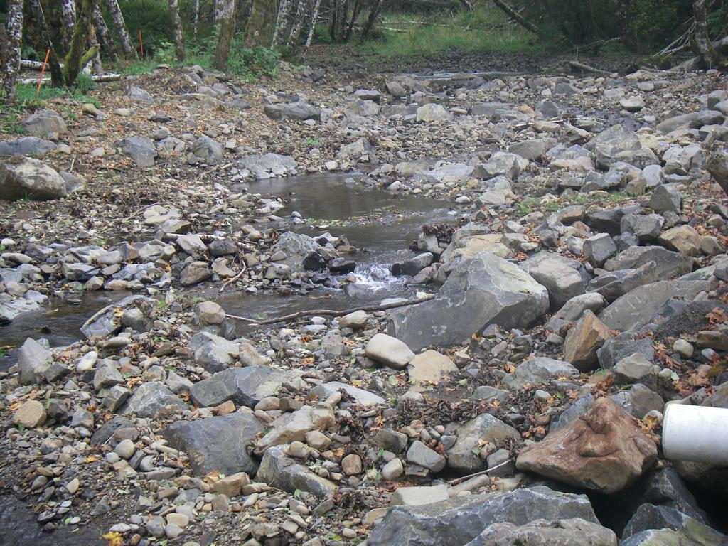
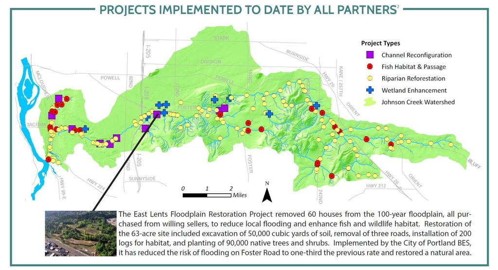
12 Of the 273 stream crossings assessed for fish passage, we found 202 or 74% of them to be fish passage barriers. -Johnson Creek Watershed Council 2015 to 2025 Action plan ( 10.4_small.pdf)

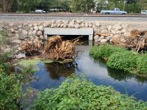
13 List of projects completed in Johnson Creek New Data Prioritization Implementation Crystal Springs Example Ongoing projects
14


15 ODFW and ODOT team up to address a big issue

16 Fish Passage Mitigation Banking

17 Passage Repair Pilot
18 Would these programs be a good fit for Johnson Creek? Is there one high priority site that would provide a 10X benefit to fish if we spent the money there, and didn t provide passage at another location? Are there other ideas for addressing some of the other questionable passage sites?


19 Completed and Upcoming..


20 The One Thing


21 Never doubt that a small group of thoughtful, committed citizens can change the world; indeed, it s the only thing that ever has. -Margaret Mead 21
22 Your time is limited, so don t waste it living someone else s life. Don t be trapped by dogma -- which is living with the results of other people s thinking. Don t let the noise of other s opinions drown out your own inner voice. And most important, have the courage to follow your heart and intuition. They some how already know what you truly want. Everything else is secondary. -Steve Jobs
Addressing the Impact of Road-Stream Crossing Structures on the Movement of Aquatic Organisms
 Scott Jackson University of Massachusetts Amherst Addressing the Impact of Road-Stream Crossing Structures on the Movement of Aquatic Organisms Dams Sub-standard Culverts Excessive Velocities Inlet Drop
Fish Passage at Road Crossings
 Fish Passage at Road Crossings 1 Crossing Design Workshop Outline 1:00 to 2:00 Intro, Design Overview, Channel Width 2:00 to 2:15 Break 2:15 to 3:15 No-Slope, Stream Simulation Design 3:15 to 3:30 Break
CFD Modeling for Structure Designs in Environmental Impacts Mitigation
 CFD Modeling for Structure Designs in Environmental Impacts Mitigation June 05 Navid Nekouee, Hugo Rodriguez and Steven Davie Environmental Impact Mitigation Design Savannah Harbor Expansion Project (SHEP)
Why Geomorphology for Fish Passage
 Channel Morphology - Stream Crossing Interactions An Overview Michael Love Michael Love & Associates mlove@h2odesigns.com (707) 476-8938 Why Geomorphology for Fish Passage 1. Understand the Scale of the
RAILWAYS AND FISH: HOW TO PROTECT AND ENHANCE FISH HABITAT VALUES AT STREAM CROSSINGS THROUGH PROJECT DESIGN AND CONSTRUCTION
 RAILWAYS AND FISH: HOW TO PROTECT AND ENHANCE FISH HABITAT VALUES AT STREAM CROSSINGS THROUGH PROJECT DESIGN AND CONSTRUCTION Rail Environment Conference November 2016 AGENDA Objective Background Benefits
U.S. ARMY CORPS OF ENGINEERS
 CORPS FACTS Regulating Mississippi River Navigation Pools U.S. ARMY CORPS OF ENGINEERS BUILDING STRONG Historical Background Federal improvements in the interest of navigation on the Mississippi River
Stream Restoration and Environmental River Mechanics. Objectives. Pierre Y. Julien. 1. Peligre Dam in Haiti (deforestation)
") Stream Restoration and Environmental River Mechanics Pierre Y. Julien Malaysia 2004 Objectives Brief overview of environmental river mechanics and stream restoration: 1. Typical problems in environmental
Stream Restoration and Environmental River Mechanics Pierre Y. Julien Malaysia 2004 Objectives Brief overview of environmental river mechanics and stream restoration: 1. Typical problems in environmental
ODFW AQUATIC INVENTORY PROJECT OREGON PLAN FOR SALMON & WATERSHEDS STREAM RESTORATION HABITAT REPORT
 ODFW AQUATIC INVENTORY PROJECT OREGON PLAN FOR SALMON & WATERSHEDS STREAM RESTORATION HABITAT REPORT STREAM: BASIN: SURVEY TYPE: Munson Creek (NC-342) Tillamook River Post-Tx DATE: February 2, 28 SURVEY
EAGLES NEST AND PIASA ISLANDS
 EAGLES NEST AND PIASA ISLANDS HABITAT REHABILITATION AND ENHANCEMENT PROJECT MADISON AND JERSEY COUNTIES, ILLINOIS ENVIRONMENTAL MANAGEMENT PROGRAM ST. LOUIS DISTRICT FACT SHEET I. LOCATION The proposed
!"#$%&&'()*+#$%(,-./0*)%(!
*+#$%(,-./0*)%(!") 8:30 Sign in Hoosic River Revival Coalition!"#$%&&'()*+#$%(,-./0*)%(! 12-#30+4/#"5-(60 9:00 Welcome and Introductions 9:15 Goals for Today s Program: A Description of the Planning Process 9:30 First Session:
8:30 Sign in Hoosic River Revival Coalition!"#$%&&'()*+#$%(,-./0*)%(! 12-#30+4/#"5-(60 9:00 Welcome and Introductions 9:15 Goals for Today s Program: A Description of the Planning Process 9:30 First Session:
Upper Mississippi River Basin Environmental Management Program Workshop
 Presentation to the Upper Mississippi River Basin Environmental Management Program Workshop by Michael Rodgers River Engineer US Army Corps of Engineers, St. Louis District August 17, 2007 Engineering
Squaw Creek. General Information
 General Information is a tributary to the Salmon River. It enters the north side of the river about 0 miles downstream of North Fork, Idaho. The study reach is about a 30 ft length of stream about 2 miles
ODFW AQUATIC INVENTORY PROJECT OREGON PLAN FOR SALMON & WATERSHEDS STREAM RESTORATION HABITAT REPORT
 ODFW AQUATIC INVENTORY PROJECT OREGON PLAN FOR SALMON & WATERSHEDS STREAM RESTORATION HABITAT REPORT STREAM: BASIN: SURVEY TYPE: South Sister Creek (U-5) Smith River Pre-Tx DATE: January 7, 4 SURVEY CREW:
Blue Mountain Province
 Rolling Provincial Review: Implementation 2001-2003 Province 23 Columbia Basin Fish & Wildlife Authority Province FY 2001-2003 Spending Summaries NPCC Recommendations and BPA Spending by Project Category,
Case Study 2: Twenty-mile Creek Rock Fords
 Case Study : Twenty-mile Creek Rock Fords Location Crossing Description Washington. Okanagan National Forest. Methow Valley Ranger District. Chewuch river basin, East Chewuch Road. The Twenty-mile Creek
Stream Geomorphology. Leslie A. Morrissey UVM July 25, 2012
 Stream Geomorphology Leslie A. Morrissey UVM July 25, 2012 What Functions do Healthy Streams Provide? Flood mitigation Water supply Water quality Sediment storage and transport Habitat Recreation Transportation
Fluvial Erosion Impacts on Infrastructure Along Indiana Rivers and Streams
 Fluvial Erosion Impacts on Infrastructure Along Indiana Rivers and Streams Siavash Beik, Robert Barr, Brian Meunier 2017 Purdue Road School March 6-9, 2017 In June 2008, flooding damaged or destroyed
Design and Construction
 Design and Construction Stream Simulation With power point slides shamelessly stolen from: Forest Service AOP Training Course Bob Gubernick Paul Anderson John Kattell USDA Forest Service Interim Directive
Tom Glass, B.S. Whitman College Sarah Wasssmund, B.S. Humboldt State University Edgar Verdin, B.S. Portland State University Kelsi Lakey, B.S.
 Tom Glass, B.S. Whitman College Sarah Wasssmund, B.S. Humboldt State University Edgar Verdin, B.S. Portland State University Kelsi Lakey, B.S. Washington State University Overview 1. Background 2. History
Lecture 2: Individual-based Modelling
 Lecture 2: Individual-based Modelling Part I Steve Railsback Humboldt State University Department of Mathematics & Lang, Railsback & Associates Arcata, California USA www.langrailsback.com 1 Outline 1.
Stream Simulation: A Simple Example
 Stream Simulation: A Simple Example North Thompson Creek, CO Paul T. Anderson U.S.D.A. Forest Service Here s How We Started May 2011 2-1 USDA-Forest Service Here s How We Finished Forest Service Aquatic
Assessment. Assessment
 2001 SPRINGBROOK CREEK RESTORATION - THREE YEAR POST-CONSTRUCTION REVIEW - Presented by Bruce Henderson and Andy Harris 2005 River Restoration Northwest Symposium Skamania Lodge, Washington www.hendersonlandservices.com
ADDRESSING GEOMORPHIC AND HYDRAULIC CONTROLS IN OFF-CHANNEL HABITAT DESIGN
 ADDRESSING GEOMORPHIC AND HYDRAULIC CONTROLS IN OFF-CHANNEL HABITAT DESIGN Conor Shea - Hydrologist U.S. Fish and Wildlife Service Conservation Partnerships Program Arcata, CA Learning Objectives Examine
Designing Sustainable Landscapes: Aquatic Barriers settings variable
 Designing Sustainable Landscapes: Aquatic Barriers settings variable A project of the University of Massachusetts Landscape Ecology Lab Principals: Kevin McGarigal, Professor Brad Compton, Research Associate
GIS Data, Technology, and Models. to Integrate Information and Improve Transportation Decision-Making. within the Eco-Logical* Framework for Oregon
 GIS Data, Technology, and Models to Integrate Information and Improve Transportation Decision-Making within the Eco-Logical* Framework for Oregon GIS-T 2009, Oklahoma City, OK April 8, 2009, Session 5..2.2
Chapter 3 Erosion in the Las Vegas Wash
 Chapter 3 Erosion in the Las Vegas Wash Introduction As described in Chapter 1, the Las Vegas Wash (Wash) has experienced considerable change as a result of development of the Las Vegas Valley (Valley).
Restoration Goals TFG Meeting. Agenda
 San Joaquin River Restoration Program Restoration Goals TFG Meeting Reach 2B Update April 28, 2010 Agenda 1. Introductions 2. Program Restoration Goal Context 3. Program Update a) Interim Flows b) EIS/EIR
Agenda. INDOT Office of Environmental Services. Describe Results of FHWA QAR. Landscape and Waterway Permitting Unit. Interviews Site Inspections
 Nathan Saxe Administrator, Ecology and Waterway Permitting Section Back to Basics: Erosion and Sediment Control FHWA INDOT Quality Assurance Review (QAR) Results 1 Agenda INDOT Office of Environmental
River Restoration and Rehabilitation. Pierre Y. Julien
 River Restoration and Rehabilitation Pierre Y. Julien Department of Civil and Environmental Engineering Colorado State University Fort Collins, Colorado River Mechanics and Sediment Transport Lima Peru
Solutions to Flooding on Pescadero Creek Road
 Hydrology Hydraulics Geomorphology Design Field Services Photo courtesy Half Moon Bay Review Solutions to Flooding on Pescadero Creek Road Prepared for: San Mateo County Resource Conservation District
Stormwater Outlet Sediment Traps
 Stormwater Outlet Traps SEDIMENT CONTROL TECHNIQUES Photo 1 Excavated sediment trap just prior to scheduled clean-out (note energy dissipater at end of pipe) Photo 2 A supplementary straw bale barrier
Appendix F Channel Grade Control Structures
 Stream Simulation Appendix F Channel Grade Control Structures This appendix briefly describes permanent grade control structures that are sometimes needed in the upstream and/or downstream reaches adjacent
Black Gore Creek 2013 Sediment Source Monitoring and TMDL Sediment Budget
 Black Gore Creek 2013 Sediment Source Monitoring and TMDL Sediment Budget Prepared for: Prepared By: - I. Introduction The Black Gore Creek Total Maximum Daily Load (TMDL) was developed in collaboration
Do you think sediment transport is a concern?
 STREAM RESTORATION FRAMEWORK AND SEDIMENT TRANSPORT BASICS Pete Klingeman 1 What is Your Restoration Project Like? k? Do you think sediment transport is a concern? East Fork Lewis River, WA Tidal creek,
Fish Passage and Abundance around Grade Control Structures on Incised Streams in Western Iowa
 Fish Passage and Abundance around Grade Control Structures on Incised Streams in Western Iowa John Thomas Hungry Canyons Alliance Mary Culler Iowa State University / Missouri DNR Dimitri Dermisis IIHR
GEOMORPHIC CHANGES IN LOWER CACHE CREEK 2012
 GEOMORPHIC CHANGES IN LOWER CACHE CREEK 2012 Eric W. Larsen Technical Memorandum Prepared for Cache Creek Technical Advisory Committee Natural Resources Program Yolo County Board of Supervisors 2012 Prepared
Observations on Surface Water in the Seminary Fen in Spring, Prepared 6/4/13 by Sam Wetterlin; updated 7/28/13
 Observations on Surface Water in the Seminary Fen in Spring, 2013 Prepared 6/4/13 by Sam Wetterlin; updated 7/28/13 Ordinarily, a calcareous fen is primarily dependent on upwelling mineral-rich, oxygen-poor
Four Mile Run Levee Corridor Stream Restoration
 Four Mile Run Levee Corridor Stream Restoration 30% Design Summary U.S. Army Corps of Engineers, Baltimore District Presentation Outline Four Mile Run 1.) Historic Perspective 2.) Existing Conditions 3.)
Tom Ballestero University of New Hampshire. 1 May 2013
 Tom Ballestero University of New Hampshire 1 May 2013 1 Hydrology 2 Basic Hydrology Low flows most common Flows that fill the stream to the banks and higher are much less common Filling the stream to the
24.0 Mineral Extraction
 Chapter 24 - Mineral Extraction 24.0 Mineral Extraction 24.1 Introduction Apart from gravel, sand, rock, limestone and salt extraction in relatively small quantities mineral extraction is not a strong
1 INTRODUCTION AND MAJOR FINDINGS... 1
 Memorandum To: Lindsey Clark, Stillwater Valley Watershed Council Coordinator From: Chad Raisland, Pioneer Technical Services, Inc. and Karin Boyd, Applied Geomorphology, Inc. CC: Tanya Lester, Stillwater
Degradation Concerns related to Bridge Structures in Alberta
 Degradation Concerns related to Bridge Structures in Alberta Introduction There has been recent discussion regarding the identification and assessment of stream degradation in terms of how it relates to
Rock Sizing for Waterway & Gully Chutes
 Rock Sizing for Waterway & Gully Chutes WATERWAY MANAGEMENT PRACTICES Photo 1 Rock-lined waterway chute Photo 2 Rock-lined gully chute 1. Introduction A waterway chute is a stabilised section of channel
Chapter Five. Synopsis
 Chapter Five Synopsis .0 Proposed Level Assessments. Prioritization of Level Assessments. Recommended Level P Locations.3 Level RAPP Locations 5 & Mosley Creek & RA.0 Proposed Level Assessments Based on
SCOPE OF PRESENTATION STREAM DYNAMICS, CHANNEL RESTORATION PLANS, & SEDIMENT TRANSPORT ANALYSES IN RELATION TO RESTORATION PLANS
 DESIGN METHODS B: SEDIMENT TRANSPORT PROCESSES FOR STREAM RESTORATION DESIGN PETER KLINGEMAN OREGON STATE UNIVERSITY CIVIL ENGINEERING DEPT., CORVALLIS 2 ND ANNUAL NORTHWEST STREAM RESTORATION DESIGN SYMPOSIUM
3/3/2013. The hydro cycle water returns from the sea. All "toilet to tap." Introduction to Environmental Geology, 5e
 Introduction to Environmental Geology, 5e Running Water: summary in haiku form Edward A. Keller Chapter 9 Rivers and Flooding Lecture Presentation prepared by X. Mara Chen, Salisbury University The hydro
Pequabuck River Flooding Study and Flood Mitigation Plan The City of Bristol and Towns of Plainville and Plymouth, CT
 Pequabuck River Flooding Study and Flood Mitigation Plan The City of Bristol and Towns of Plainville and Plymouth, CT Raymond Rogozinski and Maged Aboelata The City of Bristol and Towns of Plainville and
Learning Objectives: I can identify and interpret river flows and directions.
 Learning Objectives: I can identify and interpret river flows and directions. Bellringer Review: Check for Understanding Questions: 1 2 What Are The Key Parts Of A River s Anatomy? In your data notebooks
Guide for the determination of waterways using the spatial data layer Queensland waterways for waterway barrier works
 Guide for the determination of waterways using the spatial data layer Queensland waterways for waterway barrier works This publication has been compiled by Fisheries Queensland, Department of Agriculture,
Re: Experimental Evaluation of Fishway Modifications on the Passage Behavior of Adult Pacific Lamprey at Bonneville Dam
 Page 1 Summary Report To: David Clugston, USACE From: Eric Johnson, Matt Keefer, and Chris Peery (Fish Ecology Research Laboratory, University of Idaho), and Mary Moser (Northwest Fisheries Science Center,
Strategies for managing sediment in dams. Iwona Conlan Consultant to IKMP, MRCS
 Strategies for managing sediment in dams Iwona Conlan Consultant to IKMP, MRCS 1 Sediment trapping by dams Active storage capacity Dead storage coarse material (bed load) Fine materials (suspension) Francis
How Do Human Impacts and Geomorphological Responses Vary with Spatial Scale in the Streams and Rivers of the Illinois Basin?
 How Do Human Impacts and Geomorphological Responses Vary with Spatial Scale in the Streams and Rivers of the Illinois Basin? Bruce Rhoads Department of Geography University of Illinois at Urbana-Champaign
Conceptual Model of Stream Flow Processes for the Russian River Watershed. Chris Farrar
 Conceptual Model of Stream Flow Processes for the Russian River Watershed Chris Farrar Several features of creeks affect the interactions between surface and groundwater. This conceptual model uses the
Start of Presentation: No notes (Introductory Slide 1) 1) Salmonid Habitat Intrinsic Potential (IP) models are a type of habitat potential
 1) Salmonid Habitat Intrinsic Potential (IP) models are a type of habitat potential") The What and How of Salmonid Habitat Intrinsic Potential Modeling Start of Presentation: No notes (Introductory Slide 1) 1) Salmonid Habitat Intrinsic Potential (IP) models are a type of habitat potential
The What and How of Salmonid Habitat Intrinsic Potential Modeling Start of Presentation: No notes (Introductory Slide 1) 1) Salmonid Habitat Intrinsic Potential (IP) models are a type of habitat potential
Earth Science Floods
 Non-fiction: Earth Science - Floods Earth Science Floods When dry land is covered by water, we call it a flood. Floods are very dangerous. If they are very bad, homes can be destroyed, and people can die.
Modelling the Impacts of Dam Rehabilitation on River Ice Jam: A Case Study on the Matane River, QC, Canada
 CGU HS Committee on River Ice Processes and the Environment 19 th Workshop on the Hydraulics of Ice Covered Rivers Whitehorse, Yukon, Canada, July 9-12, 2017. Modelling the Impacts of Dam Rehabilitation
Avoiding Geohazards in the Mid-Atlantic Highlands by Using Natural Stream Principles
 Avoiding Geohazards in the Mid-Atlantic Highlands by Using Natural Stream Principles J. Steven Kite, WVU Neal Carte, WVDOT Will Harman, Michael Baker Corp. Donald D. Gray, WVU Photo: W. Gillespie North
CR AAO Bridge. Dead River Flood & Natural Channel Design. Mitch Koetje Water Resources Division UP District
 CR AAO Bridge Dead River Flood & Natural Channel Design Mitch Koetje Water Resources Division UP District Old County Road AAO Bridge Map courtesy of Marquette County Silver Lake Basin McClure Basin
-- Lessons from a successful salmon stream and estuary relocation on Gravina Island
 Re-inventing Government Creek -- Lessons from a successful salmon stream and estuary relocation on Gravina Island Jon Houghton, Ph.D. and Derek Ormerod, M.S., P.E. - Pentec Environmental/Hart Crowser,
Important Copyright Information
 Important Copyright Information The following content is provided for educational purposes by the workshop presenter. This content may or may not have been peer reviewed. Information, opinions and recommendations
Black Gore Creek Sediment Source Monitoring and TMDL Sediment Budget
 Black Gore Creek 2012 Sediment Source Monitoring and TMDL Sediment Budget Prepared for: The Eagle River Watershed Council Prepared By: RiverRestoration.org - I. Introduction Interstate 70 is a major highway
Appendix E Guidance for Shallow Flooding Analyses and Mapping
 Appendix E Guidance for Shallow Flooding Analyses and Mapping E.1 Introduction Different types of shallow flooding commonly occur throughout the United States. Types of flows that result in shallow flooding
NORTHUMBERLAND COUNTY, PA
 QUAKER RUN Stream and Wetland Restoration As-Built Completion Report and First Year Monitoring Data Coal Township NORTHUMBERLAND COUNTY, PA Upstream Before Upstream After Prepared for: COAL TOWNSHIP 805
Griswold Creek August 22, 2013
 Creek August 22, 2013 1 Lake Erie Protection Fund Creek Study ver Evaluate the overall condition of Creek Determine stable channel dimensions & appropriate restoration techniques Starting Stat gpoint for
[1] Performance of the sediment trap depends on the type of outlet structure and the settling pond surface area.
![[1] Performance of the sediment trap depends on the type of outlet structure and the settling pond surface area.](/thumbs/76/74245181.jpg "[1] Performance of the sediment trap depends on the type of outlet structure and the settling pond surface area.") Sediment Trench SEDIMENT CONTROL TECHNIQUE Type 1 System Sheet Flow Sandy Soils Type 2 System [1] Concentrated Flow Clayey Soils Type 3 System [1] Supplementary Trap Dispersive Soils [1] Performance of
Sediment Trench SEDIMENT CONTROL TECHNIQUE Type 1 System Sheet Flow Sandy Soils Type 2 System [1] Concentrated Flow Clayey Soils Type 3 System [1] Supplementary Trap Dispersive Soils [1] Performance of
ERDC/LAB TR-0X-X 100. Figure 7-3 Maximum velocity magnitudes for existing conditions for 100-year flood event
 ERDC/LAB TR-0X-X 100 Figure 7-3 Maximum velocity magnitudes for existing conditions for 100-year flood event ERDC/LAB TR-0X-X 101 Figure 7-4 Model schematization of Option 1 Figure 7-5 Bed displacement
Geomorphology Geology 450/750 Spring Fluvial Processes Project Analysis of Redwood Creek Field Data Due Wednesday, May 26
 Geomorphology Geology 450/750 Spring 2004 Fluvial Processes Project Analysis of Redwood Creek Field Data Due Wednesday, May 26 This exercise is intended to give you experience using field data you collected
Science on the Sandy River: Where is all the (Marmot) Dam sediment? Part II
 Dam sediment? Part II") Science on the Sandy River: Where is all the (Marmot) Dam sediment? Part II Johns Hopkins University National Center for Earth-surface Dynamics (NCED) Graham Matthews & Associates (GMA) Introduction Russ
Science on the Sandy River: Where is all the (Marmot) Dam sediment? Part II Johns Hopkins University National Center for Earth-surface Dynamics (NCED) Graham Matthews & Associates (GMA) Introduction Russ
Cambridge Assessment International Education Cambridge International General Certificate of Secondary Education. Published
 Cambridge Assessment International Education Cambridge International General Certificate of Secondary Education GEOGRAPHY 0460/41 Paper 4 Alternative to Coursework 017 MARK SCHEME Maximum Mark: 60 Published
Hydraulics Prof. Dr. Arup Kumar Sarma Department of Civil Engineering Indian Institute of Technology, Guwahati
 Hydraulics Prof. Dr. Arup Kumar Sarma Department of Civil Engineering Indian Institute of Technology, Guwahati Module No. # 04 Gradually Varied Flow Lecture No. # 07 Rapidly Varied Flow: Hydraulic Jump
What is a watershed or landscape perspective?
 What is a watershed or landscape perspective? -remove sediment -add sediment -add wood, riparian manipulation -alter (engineer) channel/floodplain morphology -restore/abandon roads You are here What is
Science of Natural Disasters: RIVERS& FLOODS! 27 April 2016
 Science of Natural Disasters: RIVERS& FLOODS! 27 April 2016 Rebecca Clotts Department of Geology, University of St Thomas Flood in St Paul, 2014, Star Tribune 1 2 What is a watershed? 3 4 5 6 7 What is
Assignment 1. Measuring River Characteristics- Vernon Creek. Applied Fluvial Geomorphology Field Techniques EESc 435
 Assignment 1 Measuring River Characteristics- Vernon Creek Applied Fluvial Geomorphology Field Techniques EESc 435 Amanda Jardine 30100093 Jaime McDonald 14177083 Erica Massey 50870088 April 28, 2012 Introduction
Illinois State Water Survey Division
 Illinois State Water Survey Division SURFACE WATER SECTION SWS Miscellaneous Publication 108 SEDIMENT YIELD AND ACCUMULATION IN THE LOWER CACHE RIVER by Misganaw Demissie Champaign, Illinois June 1989
Step 5: Channel Bed and Planform Changes
 Step 5: Channel Bed and Planform Changes When disturbed, streams go through a series of adjustments to regain equilibrium with the flow and sediment supply of their watersheds. These adjustments often
 http://water.usgs.gov/waterwatch/ Stream Flow Measurement: Velocity-Area method Stream discharge = Q = U * A Q = volumetric flow rate in [L 3 T -1 ] U= average stream velocity [L 2 T -1 ] A = cross sectional
Stop that Sediment! Create a plan to help the people that work, live, and play by the Toutle River
 Stop that Sediment! Create a plan to help the people that work, live, and play by the Toutle River The 1980 eruption began with an enormous landslide. As far as we know, this landslide was the largest
Rivers Trusts and NIEA Working in partnership
 Rivers Trusts and NIEA Working in partnership Lakes Symposium 5 th October 2012 Stormont Mark Horton BSc(Hons) MSc Northern Ireland Development Officer What are Rivers Trusts? Charities established to
NRCS - THUNDER ROAD #2, TRIBUTARY TO QUILEUTE RIVER CULVERT REMOVAL AND REPLACEMENT PLAN CLALLAM COUNTY, WA., WRIA: 20, SITE:
 WDFW CONTROL POINT #1 Re-Bar, Elevation 100.00 Northing 10004.441 Easting 8002.5905 WDFW CONTROL POINT #2 Re-Bar, Elevation 101.36 Northing 10031.6683 Easting 846.0623 WDFW TBM #1 Spike in Tree Elevation
Mobrand to Jones and Stokes. Sustainable Fisheries Management Use of EDT
 Sustainable Fisheries Management Use of EDT Ecosystem Diagnosis and Treatment EDT EDT designed to provide a practical, science-based approach for developing and implementing watershed plans. Provides decision
NRCS - THUNDER ROAD #3, TRIBUTARY TO QUILEUTE RIVER CULVERT REMOVAL AND REPLACEMENT PLAN CLALLAM COUNTY, WA., WRIA: 20, SITE:
 WDFW CONTROL POINT #1 Re-Bar, Elevation Northing 10004.441 Easting 8002.5905 WDFW CONTROL POINT #2 Re-Bar, Elevation 101.36 Northing 10031.6683 Easting 846.0623 Spike in Tree Elevation = 102.95 Elevation
Oregon Department of Transportation. Geographic Information Systems Strategic Plan
 Oregon Department of Transportation Geographic Information Systems Strategic Plan Adopted May, 2000 By the GIS Steering Committee Last printed 10/2/2012 4:20:00 PM Page Geographic Information Systems Strategic
APPENDIX A M&T/Llano Seco Long-Term Water Reliability Study These photos are examples of rock spurs in use throughout the United States
 APPENDIX A M&T/Llano Seco Long-Term Water Reliability Study These photos are examples of rock spurs in use throughout the United States Glenn Colusa Irrigation District completed a Sacramento River project
Stream Restoration Asset Mapping
 Stream Restoration Asset Mapping John Dean Amy Bergbreiter March 27, 2014 Georgia Association of Floodplain Management Conference Hyatt Regency, Atlanta, GA Sediment comes mostly from stream banks, not
ODFW AQUATIC INVENTORY PROJECT RESTORATION MONITORING STREAM HABITAT REPORT. Peggy Kavanagh, Trevan Cornwell TOLEDO SOUTH Coast Range Lora Tennant
 ODFW AQUATIC INVENTORY PROJECT RESTORATION MONITORING STREAM HABITAT REPORT STREAM: GCG: 2-MC SITE ID: 489 BASIN: YAQUINA TREATMENT DATE: 24 SURVEY DATE: 2/27/24 SURVEY CREW: USGS MAPS: ECOREGION: REPORT
Dolores River Watershed Study
 CHAPTER 4: RIVER AND FLOODPLAIN ISSUES The Dolores River falls into a category of streams in Colorado that share some unique characteristics. Like some other mountain streams in the state, it has a steep
U-Shaped Sediment Traps
 U-Shaped Sediment Traps SEDIMENT CONTROL TECHNIQUE Type 1 System Sheet Flow Sandy Soils Type 2 System Concentrated Flow Clayey Soils [1] Type 3 System Supplementary Trap Dispersive Soils [1] Generally
1.060 Engineering Mechanics II Spring Problem Set 8
 1.060 Engineering Mechanics II Spring 2006 Due on Monday, May 1st Problem Set 8 Important note: Please start a new sheet of paper for each problem in the problem set. Write the names of the group members
Swift Creek Sediment Management Action Plan (SCSMAP)
") Swift Creek Sediment Management Action Plan (SCSMAP) PHASE 3 PROJECT PLAN PROPOSAL Whatcom County Public Works Department 322 N. Commercial Street, Suite 210 Bellingham, WA 98225 (360) 676-6692 June 2013
Swift Creek Sediment Management Action Plan (SCSMAP) PHASE 3 PROJECT PLAN PROPOSAL Whatcom County Public Works Department 322 N. Commercial Street, Suite 210 Bellingham, WA 98225 (360) 676-6692 June 2013
Fluvial Driven Alluvial Fans
 Fluvial Driven Alluvial Fans Restoration Project Evaluations - Examples from the Russian and Napa River Watersheds Mia Docto Masters Thesis UC Berkeley 1. Basic Fan Description 2. Fluvial Driven Fan Characteristics
Aquifer an underground zone or layer of sand, gravel, or porous rock that is saturated with water.
 Aggradation raising of the streambed by deposition that occurs when the energy of the water flowing through a stream reach is insufficient to transport sediment conveyed from upstream. Alluvium a general
Appendix A Flood Damages in 2013
 Appendix A Flood Damages in 2013 RPT2-2014-07-09-App_A_Highwood_River_Flood_Damage_In_2013.Docx Table of Contents page Sign-Off 1. Flood Damage in 2013... 1 1.1 Background... 1 1.2 Town of High River...
Bank stabilization by redirective structures on the Santa Clara River, Ventura County, CA
 116 Alex Yescas Senior Water Resources Engineer Atkins North America Bank stabilization by redirective structures on the Santa Clara River, Ventura County, CA Abstract The Santa Clara River is one of the
 Red River Flooding June 2015 Caddo and Bossier Parishes Presented by: Flood Technical Committee Where the Rain Falls Matters I-30 versus I-20 I-20 Backwater and Tributary Floods (Localized) 2016 Flood
Red River Levee Panel
 Red River Levee Panel Mississippi River Commission Monday, August 9, 2017 Red River Levees in LA & AR NONE along TX & OK Boarder Red River Levee Issues Caddo Levee Cherokee Park Authorization Bossier Levee
Amherst. University of Massachusetts - Amherst
 University of Massachusetts - Amherst ScholarWorks@UMass Amherst International Conference on Engineering and Ecohydrology for Fish Passage International Conference on Engineering and Ecohydrology for Fish
RESERVOIR DRAWDOWN RATES/RESERVOIR DRAWDOWN TEST Iron Gate, Copco (I & II), and JC Boyle Dams
, and JC Boyle Dams") TECHNICAL MEMORANDUM No. 1 TO: Michael Bowen California Coastal Conservancy Geotechnical & Earthquake Engineering Consultants CC: Eric Ginney Philip Williams & Associates PREPARED BY: Paul Grant SUBJECT:
TECHNICAL MEMORANDUM No. 1 TO: Michael Bowen California Coastal Conservancy Geotechnical & Earthquake Engineering Consultants CC: Eric Ginney Philip Williams & Associates PREPARED BY: Paul Grant SUBJECT:
Restoring Meanders to Straightened Rivers 1.5 New meandering channel replacing concrete weirs
 .5 New meandering channel replacing concrete weirs River Marden Location Town centre at Calne, Wiltshire ST99870 Date of construction 999 Length 00m Cost not available River course prior to works New shopping
Session C1 - Applying the Stream Functions Pyramid to Geomorphic Assessments and Restoration Design
 University of Massachusetts - Amherst ScholarWorks@UMass Amherst International Conference on Engineering and Ecohydrology for Fish Passage International Conference on Engineering and Ecohydrology for Fish
Gully Erosion Part 1 GULLY EROSION AND ITS CAUSES. Introduction. The mechanics of gully erosion
 Gully Erosion Part 1 GULLY EROSION AND ITS CAUSES Gully erosion A complex of processes whereby the removal of soil is characterised by incised channels in the landscape. NSW Soil Conservation Service,