GLIDE: Global Unique Disaster Identifier for Effective Sharing of Disaster Information
|
|
|
- Alexia Bryant
- 5 years ago
- Views:
Transcription


1 2018/SOM1/EPWG/023 Agenda Item: 12.1 GLIDE: Global Unique Disaster Identifier for Effective Sharing of Disaster Information Purpose: Information Submitted by: Japan 13 th Emergency Preparedness Working Group Meeting Port Moresby, Papua New Guinea February 2018
2 13th APEC Emergency Preparedness Working Group Meeting Port Moresby, Papua New Guinea February 24-25, DRR policy priorities and APEC DRR Framework implementation. GLIDE: Global Unique Disaster Identifier for effective sharing of Disaster Information Asian Disaster Reduction Center
3 Identifying natural disasters GLIDE :GLobal unique disaster IDEntifier GLIDE has been widely used for effective sharing of disaster data sources among diverse organizations. GLIDE facilitates identifying APEC wide effects of natural disasters. Case of Aitape Tsunami TS PNG Hazard Code Year Serial Number ISO Code ex. DR: Drought EQ: Earthquake EP: Epidemic FL: Flood TS: Tsunami LS: Land Slide SS: Storm surge VO: Volcano WF: Wild Fire ST: Wild Storm


4 GLIDE has been referred to by many organizations GLIDE numbers issued between 2001 to 2016 amounted to approximately In 2017, 197 GLIDE numbers were issued in total including 48 for APEC economies. GLIDE No GLIDE No GLIDE No GLIDE No GLIDE No GLIDE No 3
5 Recent Disasters and the GLIDE numbers In 2018, as of February 17 th, 16 GLIDE numbers have been issued including three for APEC economies, as follows: GLIDE number Event Country Comments VO PNG Volcano PNG The Kadovar volcano, previously considered dormant, has erupted for the first time in known history. As of 6th of January, over half of the island was covered in volcanic products. The darkening color of the ash indicates that is a high potential for the eruption to become explosive. Due to the steepness of the volcano, there is a high risk for landslides. In case of an explosion, tsunamis can also be expected to affect Kadovar and the nearby islands. VO PHL Volcano Philippines On Sunday, 14th of January 2017 Philippine Institute of Volcanology and Seismology increased the alert level for Mount Mayon to three (scale 1-5), which indicates a prospect of hazardous eruption within the following weeks or even days. On Monday, 15th, ash clouds were seen erupting from the crater with lava falling down the slopes. At least people living nearby have fled their homes. EP IDN Epidemic Indonesia On 16 January 2018, Indonesian Ministry of Health has declared a measles outbreak and malnutrition in the Asmat District of the Papua Province. The National Health Crisis Centre activated its public health emergency operation center to monitor the impact of the crisis regularly. As of 21 January 2018, at least 602 positive measles cases have been identified. Papua, as one of the poorest area of Indonesia, has a poor food security status. A large proportion of the population, especially children, are suffering of malnutrition and weakened immunity, which makes them more vulnerable to measles and its complications. Only 17 % of the area's population are vaccinated against measles.
6 Backgrounds of GLIDE 2001 March ADRC proposed a Disaster Unique ID, a proto type of GLIDE August The name GLIDE was agreed by Relief Web, IFRC, FAO, ISDR, UNDP, LaRED, WB at the Technical Advisory Group Meeting by CRED in Brussels 2002 January GLIDE number issuing has been initiated by CRED 2004 May GLIDENUMBER.NET has come into operation 2005 March WCDR in Hyogo: GLIDE As the common international language 2006 GLIDE number has become a basic information for Sentinel Asia operation ADRC undertook an ASEAN cooperation project of Capacity building Training targeting for 10 ASEAN countries March WCDRR in Sendai: UN-ISDR-ADRC informal exchanges on GLIDE 2016 February ACDR2016 in Phuket: A follow up Workshop on ASEAN Cooperation Project November AMCDRR at Delhi, in a Thematic Event Partnerships and Innovations for improving Disaster Loss Accounting
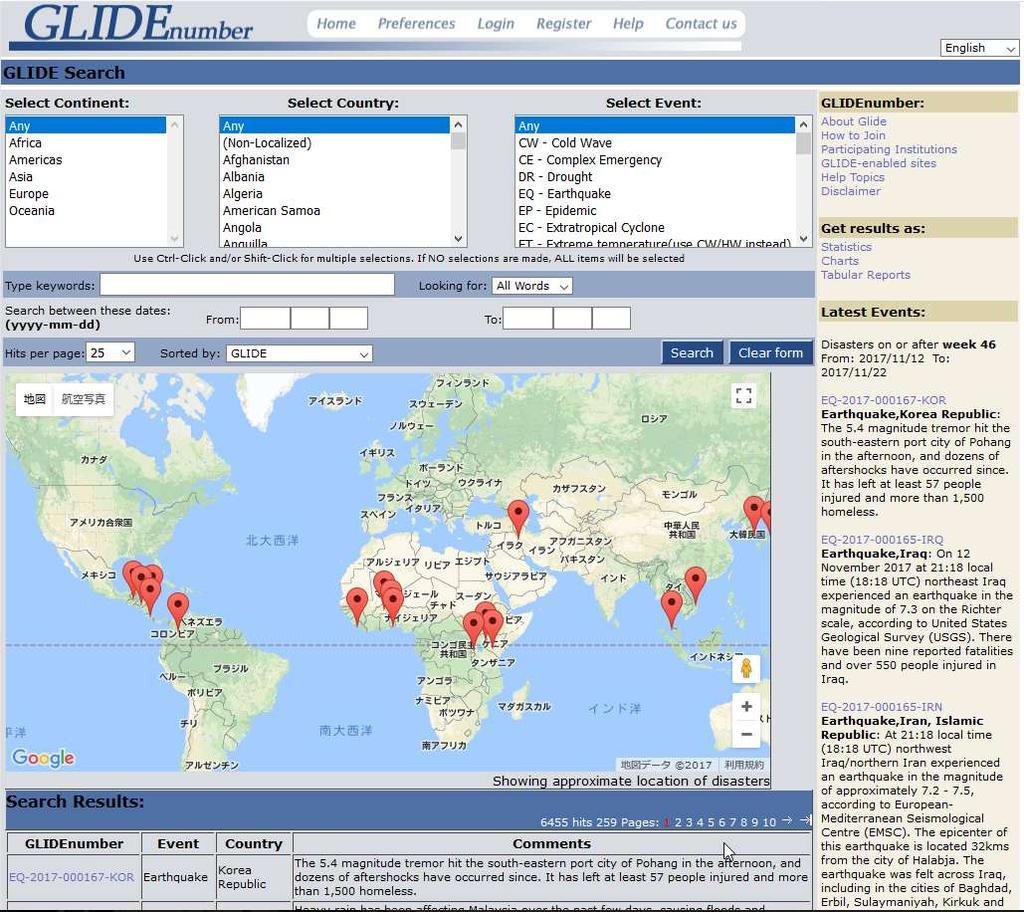
7 GLIDE number Event Comments EQ IRN GLIDE numbers facilitate identifying disasters Case: Two earthquakes that hit Mexico in 2017 Dates GLIDE number Event Comments 2017/9/19 EQ MEX Earthquake 2017/9/8 EQ MEX Earthquake Case: The earthquake that hit Iran and Iraq in 2017 Earthquake in Iran On 9/19/2017 6:14:39 PM, an earthquake occurred in Mexico potentially affecting people within 100km. The earthquake had Magnitude 7.1M, Depth:51.01km. An earthquake of magnitude 8 at a depth of 35 km occurred near the southwestern coasts of Chiapas State on 8 September at 4.49 UTC. The epicentre was located approx. 96 km southwest of Pijijiapan city (population people). USGS PAGER estimated a shaking up to "Severe" for people and up to "Very Strong" for people. At 21:18 local time (18:18 UTC) northwest Iraq/northern Iran experienced an earthquake in the magnitude of approximately , according to European-Mediterranean Seismological Centre (EMSC). The epicenter of this earthquake is located 32kms from the city of Halabja. The earthquake was felt across Iraq, including in the cities of Baghdad, Erbil, Sulaymaniyah, Kirkuk and Basra. EQ IRQ Earthquake in Iraq On 12 November 2017 at 21:18 local time (18:18 UTC) northeast Iraq experienced an earthquake in the magnitude of 7.3 on the Richter scale, according to United States Geological Survey (USGS). There have been nine reported fatalities and over 550 people injured in Iraq.

8 GLIDE as an effective information sharing tool for natural disasters affecting many economies The Indian Ocean Tsunami and Earthquake, /Dec/2004 Tsunami hits Sumatra in Indonesia Tsunami hits Phuket and southern Thailand Tsunami hits northern Malaysia Tsunami hits southern Sri Lanka Tsunami hits Southeast India Tsunami hits Myanmar Tsunami hits Bangladesh Tsunami hits Maldives Tsunami hits Somalia TS IDN TS THA TS MYS TS LKA TS IND TS MMR TS BGD TS MDV TS SOM 7
9 Identifying a typhoon and relevant disasters affecting many economies
10 Glide numbers for APEC region by types of disasters Flood Tropical Cyclone SEVERE LOCAL STORM Earthquake Land Slide Wild fire Drought Volcano Epidemic Flash Flood Cold Wave SLIDE Tornadoes Extreme temperature Tsunami Mud Slide Heat Wave Violent Wind Storm Surge Extratropical Cyclone Wave/Surge Snow Avalanche Source: ADRC

11 Source: ADRC Glide numbers by APEC economy
12 Towards building DRR knowledge bases GLIDE could be used as a key tool to facilitate: -identifying natural disasters on which we need information -linking databases developed for diverse DRR purposes by different organizations and - sharing information and establishing knowledge bases for DRR cooperation beyond borders
13

14 Thank you very much
Natural Disasters in Member Countries (2002 Summary)
") 4.2 Member Countries and their Disaster Characteristics: Table 5: Natural Disasters in Member Countries (2002 Summary) (Country/Disaster Type/Disaster Characteristics) Data Country DisType Count of TotAff
4.2 Member Countries and their Disaster Characteristics: Table 5: Natural Disasters in Member Countries (2002 Summary) (Country/Disaster Type/Disaster Characteristics) Data Country DisType Count of TotAff
Sentinel Asia Data Provider Node Report
 Sentinel Asia Data Provider Node Report Joint Project Team Meeting for Sentinel Asia STEP3 (JPTM2018) 23 24 January 2018, Taipei, Taiwan Yuji TAKADA Space Applications and Operations Center (SAOC) Japan
Global Map: A Tool for Disaster Mitigation for the Asia and Pacific Region
 Global Map: A Tool for Disaster Mitigation for the Asia and Pacific Region D. R. Fraser Taylor Chair, International Steering Committee for Global Mapping (ISCGM) fraser_taylor@carleton.ca www. 18 th United
Kadovar Eruption: Multi-Hazard Monitoring and Response
 2018/SOM1/EPWG/016 Agenda Item: 11.10 Kadovar Eruption: Multi-Hazard Monitoring and Response Purpose: Information Submitted by: Papua New Guinea 13 th Emergency Preparedness Working Group Meeting Port
Capacity Building in Applications of Remote Sensing and GIS for Disaster Management
 Capacity Building in Applications of Remote Sensing and GIS for Disaster Management M.K. Hazarika, L. Samarakoon, N. Senevirathne, J.S.M. Fowze and R. de Silva Project Researcher GeoInformatics Center
2018 REVIEW OF DISASTER EVENTS
 2018 REVIEW OF DISASTER EVENTS Supplementary Information* BRUSSELS, 24 January, 2019 In 2018, there were 281 climate-related and geophysical events recorded in the EM-DAT (International Disaster Database)
10 emergency observation requests were successfully processed during the period
 ISRO s Inputs for the Sentinel Asia DPN and JPT meeting being held during 13-16, 16, November 2012 November 2012 Sentinel Asia Activity Spectrum - A dedicated Sentinel Asia server established at NRSC,
Word Cards. 2 map. 1 geographic representation. a description or portrayal of the Earth or parts of the Earth. a visual representation of an area
 Name: Date: Hour: Word Cards 1 geographic representation a description or portrayal of the Earth or parts of the Earth Example: A map is a representation of an actual location or place. 2 map a visual
KARI Activation for the International Disasters
 KARI Activation for the International Disasters 5 th Joint Project Team Meeting for Sentinel Asia STEP2 (JPTM2012) 14 th Nov 2012 Boyeol Yoon Senior Researcher, Satellite Information Research Center (SIRC)
Initiative. Country Risk Profile: papua new guinea. Better Risk Information for Smarter Investments PAPUA NEW GUINEA.
 Pacific Catastrophe Risk Assessment And Financing Initiative PAPUA NEW GUINEA September 211 Country Risk Profile: papua new is expected to incur, on average, 85 million USD per year in losses due to earthquakes
South, Southeast, and East Asia. Physical Geography
 South, Southeast, and East Asia Physical Geography Mountains v Mountains are important in Asia because they influence: A. Population patterns B. Movement of people and goods C. Climate Mountains v The
RESAP Progress Report
 RESAP Progress Report December 2016 to October 2017 Presentation to the Twenty-first session of the Intergovernmental Consultative Committee on the Regional Space Applications Programme for Sustainable
The Indian Ocean. Copyright 2010 LessonSnips
 The Indian Ocean One of the five major geographic divisions of the world s ocean, the Indian Ocean is located in the Eastern Hemisphere. The Indian Ocean is bounded by three continents: Africa to the west,
Disaster Management and Spatial Data An Experience of Sri Lanka for Joint project team meeting 2012
 Disaster Management and Spatial Data An Experience of Sri Lanka for Joint project team meeting 2012 1 by Padma Kumara Withana Provincial Surveyor General Uva Province 2 Out line ü Introduction ü Natural
Earthquake Risk in Indonesia
 過去の火災事例 MM I TTSS UU I SSUU MMI I TTOO MMOO I NN SSUURR AA NN CC EE GG RR OOUUPP INTTEERRI I ISSK AASSI IAA PPTTEE LLTTD... Earthquake Risk in Indonesia October 2009 In Indonesia, the Sumatra Earthquake
Integrated and Multi-Hazard Disaster Management
 GeoSmart Asia 2016: GI for Disaster Preparedness and Risk Reduction Bandung, Indonesia 12 October 2016 Integrated and Multi-Hazard Disaster Management Lim Choun Sian & Nurfashareena Muhamad Centre for
Theme 4. Disaster Mitigation and Risk Management
 Theme 4 Disaster Mitigation and Risk Management World Flood Map in 2002 Released by WMO as of August 29 Over 17 million were affected (in more than 80 countries) 3,000 were killed Total damage of over
Cambridge International Examinations Cambridge International General Certificate of Secondary Education
 Cambridge International Examinations Cambridge International General Certificate of Secondary Education *7731101867* ENVIRONMENTAL MANAGEMENT 0680/21 Paper 2 October/November 2014 1 hour 45 minutes Candidates
Mainstream Space Technology in Implementing SFDRR - GPSTAR. Srimal Samansiri Disaster Management Centre Government of Sri Lanka
 Mainstream Space Technology in Implementing SFDRR - GPSTAR Srimal Samansiri Disaster Management Centre Government of Sri Lanka SFDRR Priority Actions Effective use of Space technology in SFDRR Priority
1. Impacts of Natural Disasters by Region, 2008
 1. Impacts of Natural Disasters by Region, 2008 Among all regions across the world in 2008, Asia not only ranks first but also dominates in all natural disaster s impact categories occurrence, killed,
A Questionnaire on the Utilization of Satellite Data from the New Generation of Geostationary Meteorological Satellites
 3.1 User requirements for satellite data utilization, especially for new-generation satellites A Questionnaire on the Utilization of Satellite Data from the New Generation of Geostationary Meteorological
Tectonic Processes and Hazards Enquiry Question 1: Why are some locations more at risk from tectonic hazards?
 Tectonic Processes and Hazards Enquiry Question 1: Why are some locations more at risk from tectonic hazards? Key words Basalt Andesite Rhyolite Benioff Zone Subduction zone Crustal fracturing Definition
Country Report Vanuatu
 Country Report Vanuatu Ministry Infrastructure and Public Utilities. Application of Space Technology and the Geographic information system for DRR and Sustainable Development 18 th 22 nd December 2012
MODELLING FROST RISK IN APPLE TREE, IRAN. Mohammad Rahimi
 WMO Regional Seminar on strategic Capacity Development of National Meteorological and Hydrological Services in RA II (Opportunity and Challenges in 21th century) Tashkent, Uzbekistan, 3-4 December 2008
Workshop on Drought and Extreme Temperatures: Preparedness and Management for Sustainable Agriculture, Forestry and Fishery
 Workshop on Drought and Extreme Temperatures: Preparedness and Management for Sustainable Agriculture, Forestry and Fishery 16-17 Feb.2009, Beijing, China Modeling Apple Tree Bud burst time and frost risk
5.2 IDENTIFICATION OF HAZARDS OF CONCERN
 5.2 IDENTIFICATION OF HAZARDS OF CONCERN 2015 HMP Update Changes The 2010 HMP hazard identification was presented in Section 6. For the 2015 HMP update, the hazard identification is presented in subsection
The Third UN-GGIM-AP Plenary Meeting. Use of Geospatial Information in Disaster and Coordination among NDMA and Relevant Organizations/Stakeholders
 The Third UN-GGIM-AP Plenary Meeting Use of Geospatial Information in Disaster and Coordination among NDMA and Relevant Organizations/Stakeholders Bali Indonesia 10 November 2014 Bernardus Wisnu Widjaja
Space Applications for Disaster Risk Reduction and Sustainable Development
 Space Applications for Disaster Risk Reduction and Sustainable Development Space Applications Section (SAS) ICT and Disaster Risk Reduction Division (IDD) UNESCAP Contents I. RESAP Activities 2016-2017
held on 4 June 2013 Prof. Yoshimori Honkura, Program Officer of Japan Science and Technology Agency (JST) Jakarta, Indonesia Pan Pacific Hotel)
 Jakarta, Indonesia Pan Pacific Hotel)") Overview of the Outcomes from e-asia JRP Disaster Prevention Workshop held on 4 June 2013 Prof. Yoshimori Honkura, Program Officer of Japan Science and Technology Agency (JST) Jakarta, Indonesia (@Sari
Overview of the Outcomes from e-asia JRP Disaster Prevention Workshop held on 4 June 2013 Prof. Yoshimori Honkura, Program Officer of Japan Science and Technology Agency (JST) Jakarta, Indonesia (@Sari
Building Institutional Capacity for Multi-Hazard Early Warning in Asia and the Pacific Subtitle
 Building Institutional Capacity for Multi-Hazard Early Warning in Asia and the Pacific Subtitle Title Keran Wang Chief, Space Applications Section ICT and Disaster Risk Reduction Division 22 May 2018 Pillar
WMO Statement on the State of the Global Climate Preliminary conclusions for 2018 and WMO Greenhouse Bulletin
 WMO Statement on the State of the Global Climate Preliminary conclusions for 2018 and WMO Greenhouse Bulletin Dr Elena Manaenkova Deputy Secretary General World Meteorological Organisation Statement on
Meteorological Hazards and Current Approach to Observing, Modelling and Predicting Severe Events in Sri Lanka
 Regional Workshop on Impact-based Forecasts in RA II (Asia) 7-9, November, 2017, Seoul, Republic of Korea Meteorological Hazards and Current Approach to Observing, Modelling and Predicting Severe Events
The Regional Integrated Multi-Hazard Early Warning System for Africa and Asia CAP in RIMES
 The Regional Integrated Multi-Hazard Early Warning System for Africa and Asia CAP in RIMES 2018 CAP Implementation Workshop OUTLINE 1. RIMES Overview 2. DSS tools developed in RIMES 3. CAP Integration
Bistandsprosjekter i Sørøst-Asia
 Bistandsprosjekter i Sørøst-Asia -Sikre liv og verdier Lars R. Hole, Hanneke Luijting, Tor Ivar Mathisen og Kristine Gjesdal September 2017 Norwegian Meteorological Institute Background Ministry of Foreign
Use of geo-referenced data for DRM in Central Asia, problems and prospective
 Use of geo-referenced data for DRM in Central Asia, problems and prospective Dr. Akylbek Chymyrov Director, Kyrgyz Center of Geoinformation Systems Member of the Public Supervisory Board MES KR KSUCTA,
GI Technology for Disaster Management
 GI Technology for Disaster Management 17 th ICC on the Regional Space Applications Programme for Sustainable Development (RESAP) 26 th Nov 2013 Bangkok Thailand Period and time of seasonal in thailand
UPDATE OF REGIONAL WEATHER AND SMOKE HAZE February 2016
 UPDATE OF REGIONAL WEATHER AND SMOKE HAZE February 2016 1. Review of Regional Weather Conditions in January 2016 1.1 The Northeast Monsoon conditions prevailed in the region in January 2016. With the monsoon
Cambridge International Examinations Cambridge International General Certificate of Secondary Education
 Cambridge International Examinations Cambridge International General Certificate of Secondary Education *4298138811* ENVIRONMENTAL MANAGEMENT 0680/23 Paper 2 October/November 2014 1 hour 45 minutes Candidates
KUALA LUMPUR MONSOON ACTIVITY CENT
 T KUALA LUMPUR MONSOON ACTIVITY CENT 2 ALAYSIAN METEOROLOGICAL http://www.met.gov.my DEPARTMENT MINISTRY OF SCIENCE. TECHNOLOGY AND INNOVATIO Introduction Atmospheric and oceanic conditions over the tropical
Table ronde 5 : Cartographie d'urgence Emergency Mapping.
 Table ronde 5 : Cartographie d'urgence Emergency Mapping MapAction is an international NGO that provides maps and other information services to help humanitarian relief organisations in the field MapAction
Satellite Earth Observation - Educational initiatives of Belgian Science Policy 10 YEARS OF IMAGING ASIA SPOT VEGETATION
 The Neverending Battle with Nature Natural disasters occur everywhere in the world, in all their various forms: earthquakes, volcanoes, tsunamis, hurricanes, floods... Their appearance naturally largely
South Asian Climate Outlook Forum (SASCOF-6)
") Sixth Session of South Asian Climate Outlook Forum (SASCOF-6) Dhaka, Bangladesh, 19-22 April 2015 Consensus Statement Summary Below normal rainfall is most likely during the 2015 southwest monsoon season
Sixth Session of South Asian Climate Outlook Forum (SASCOF-6) Dhaka, Bangladesh, 19-22 April 2015 Consensus Statement Summary Below normal rainfall is most likely during the 2015 southwest monsoon season
5.2 IDENTIFICATION OF HAZARDS OF CONCERN
 5.2 IDENTIFICATION OF HAZARDS OF CONCERN 2016 HMP Update Changes The 2011 HMP hazard identification was presented in Section 3. For the 2016 HMP update, the hazard identification is presented in subsection
28 th March 2005 magnitude 8.7 earthquake Northern Sumatra, Indonesia
 29 th March 2005 GAPResponse 28 th March 2005 magnitude 8.7 earthquake Northern Sumatra, Indonesia Russell Blong T: +61 2 8209 4288 F: +61 2 9241 2441 E: russell.blong@benfieldgroup.com Ben Miliauskas
Year 4 Geography Revision Pack Summer 2018 Name
 Year 4 Geography Revision Pack Summer 2018 Name Welcome to your geography revision pack for the upcoming Summer exams. Everything that we have been working on in lessons since Christmas will be covered
Natural Disasters in 2002: An Analytical Overview
 Natural Disasters in 2002: An Analytical Overview Chapter 1: Impact of Natural Disasters This Chapter deals with the overall trend and impact of Natural Disasters in the year 2002. It also addresses regional
Geospatial application in Kiribati
 Geospatial application in Kiribati ICC-21 ST RESAP (9 TH TO 13 TH OCTOBER, 2017) BANGKOK, THAILAND Outline Kiribati Profile Natural disasters in Kiribati Achievements Challenges/Issues Ways forward 1 Kiribati
CANBERRA SECONDARY SCHOOL Preliminary Examination 2
 CANBERRA SECONDARY SCHOOL 2015 Preliminary Examination 2 Secondary Four (Normal Academic) COMBINED HUMANITIES 11 August 2015 Geography Elective (2194/02) 1 hour 40 minutes 10.30 12.10 Name: ( ) Class:
5.2 IDENTIFICATION OF HAZARDS OF CONCERN
 5.2 IDENTIFICATION OF HAZARDS OF CONCERN 2016 HMP Update Changes The 2011 HMP hazard identification was presented in Section 3. For the 2016 HMP update, the hazard identification is presented in subsection
Disclaimer. This report was compiled by an ADRC visiting researcher (VR) from ADRC member countries.
 from ADRC member countries.") Disclaimer This report was compiled by an ADRC visiting researcher (VR) from ADRC member countries. The views expressed in the report do not necessarily reflect the views of the ADRC. The boundaries and
Disclaimer This report was compiled by an ADRC visiting researcher (VR) from ADRC member countries. The views expressed in the report do not necessarily reflect the views of the ADRC. The boundaries and
5.2 IDENTIFICATION OF HAZARDS OF CONCERN
 5.2 IDENTIFICATION OF HAZARDS OF CONCERN To provide a strong foundation for mitigation actions considered in Sections 6 and 9, County focused on considering a full range of s that could impact area, and
World Meteorological Organization
 Appendix VI Presentation on disaster risk reduction brainstorming session (1) World Meteorological Organization WMO DRR Programme Dieter C. Schiessl Director, Weather and Disaster Risk Reduction Services
Volcanoes. Introduction
 Volcanoes Introduction Display Slide V-0 Explain that a volcano is a vent through which molten rock escapes to the Earth s surface. Unlike other mountains, which are pushed up from below, volcanoes are
A Presentation By: Dr. G. M. Dar Centre for Disaster Management & Env. Studies, J&K IMPA, Srinagar
 A Presentation By: Dr. G. M. Dar Centre for Disaster Management & Env. Studies, J&K IMPA, Srinagar Introduction Disaster: Sudden or great misfortune. A catastrophe, a calamitous event. Hazards are a natural
at IHO IRCC7 Mexico City, Mexico, June 2015
 Report on Japan s Response to Disasters presented by JHOD at IHO IRCC7 Mexico City, Mexico, 01 03 June 2015 JAPAN COAST GUARD Actions against huge earthquake Actions taken by JHOD against the Great East
Copernicus Overview and Emergency Management Service
 Copernicus Overview and Emergency Management Service Frédéric BASTIDE European Commission Open informal session of the United Nations Inter-Agency Meeting on Outer Space Activities 12 March 2013, Geneva
UPDATE OF REGIONAL WEATHER AND SMOKE HAZE (December 2017)
") UPDATE OF REGIONAL WEATHER AND SMOKE HAZE (December 2017) 1. Review of Regional Weather Conditions for November 2017 1.1 In November 2017, Southeast Asia experienced inter-monsoon conditions in the first
UPDATE OF REGIONAL WEATHER AND SMOKE HAZE (December 2017) 1. Review of Regional Weather Conditions for November 2017 1.1 In November 2017, Southeast Asia experienced inter-monsoon conditions in the first
Early Warning System and Role of IMD. Manmohan Singh Meteorological Centre Shimla
 Early Warning System and Role of IMD Manmohan Singh Meteorological Centre Shimla India a land with a unique climatic regime Two monsoon seasons (southwest & northeast monsoons) Two cyclone seasons (pre
Pacific Catastrophe Risk Assessment And Financing Initiative
 Pacific Catastrophe Risk Assessment And Financing Initiative TIMOR-LESTE September Timor-Leste is expected to incur, on average, 5.9 million USD per year in losses due to earthquakes and tropical cyclones.
Bhutan Country Report for JPTM 2010 (July, 2010) Department of Disaster Management Ministry of Home & Cultural Affairs Royal Government of Bhutan
 Department of Disaster Management Ministry of Home & Cultural Affairs Royal Government of Bhutan") Bhutan Country Report for JPTM 2010 (July, 2010) Department of Disaster Management Ministry of Home & Cultural Affairs Royal Government of Bhutan 1 Contents of Presentation 1. Disaster Hazards and Underlying
Bhutan Country Report for JPTM 2010 (July, 2010) Department of Disaster Management Ministry of Home & Cultural Affairs Royal Government of Bhutan 1 Contents of Presentation 1. Disaster Hazards and Underlying
9. Case study on disaster events using radar data
 9. Case study on disaster events using radar data 9 February 2018 Masahito ISHIHARA Former Meteorologist/Researcher of Japan Meteorological Agency Former Professor of Kyoto University 9. Case study on
INTRODUCTION OF A SUCCESS STORY IN THE PHILIPPINES
 INTRODUCTION OF A SUCCESS STORY IN THE PHILIPPINES Arturo S. Daag Department of Science and Technology Philippine Institute of Volcanology and Seismology (DOST-PHIVOLCS) Establishment of Sentinel Asia
Australia Government Geospatial Capacity Building Efforts in Asia and the Pacific. Dr John Dawson
 Australia Government Geospatial Capacity Building Efforts in Asia and the Pacific Dr John Dawson Presentation Overview About Geoscience Australia Examples of Geospatial Capacity Building Activity Geodesy
Georeferencing and Satellite Image Support: Lessons learned, Challenges and Opportunities
 Georeferencing and Satellite Image Support: Lessons learned, Challenges and Opportunities Shirish Ravan shirish.ravan@unoosa.org UN-SPIDER United Nations Office for Outer Space Affairs (UNOOSA) UN-SPIDER
5.2. IDENTIFICATION OF NATURAL HAZARDS OF CONCERN
 5.2. IDENTIFICATION OF NATURAL HAZARDS OF CONCERN To provide a strong foundation for mitigation strategies considered in Sections 6 and 9, County considered a full range of natural hazards that could impact
Also, when Cascade volcanoes do erupt, high-speed avalanches of pyroclastic flows
 INTRODUCTION A volcano is a vent through which molten rock escapes to the Earth s surface. Unlike other mountains, which are pushed up from below, volcanoes are built by surface accumulation of their eruptive
UPDATE OF REGIONAL WEATHER AND SMOKE HAZE (February 2018)
") UPDATE OF REGIONAL WEATHER AND SMOKE HAZE (February 2018) 1. Review of Regional Weather Conditions for January 2018 1.1 The prevailing Northeast monsoon conditions over Southeast Asia strengthened in January
UPDATE OF REGIONAL WEATHER AND SMOKE HAZE (February 2018) 1. Review of Regional Weather Conditions for January 2018 1.1 The prevailing Northeast monsoon conditions over Southeast Asia strengthened in January
Enhancing Preparedness and Early Warning in Disaster Risk Reduction
 Enhancing Preparedness and Early Warning in Disaster Risk Reduction Fifth Technical Conference on Management of Meteorological and Hydrological Services in Regional Association V at PETALING JAYA, MALAYSIA
Lesson 8. Natural Disasters
 Lesson 8 Natural Disasters 1 Reading is NOT a spectator sport! 2 Reading requires active participation! 3 PREDICT Try to figure out what information will come next and how the selection might end. 4 Natural
Indian Ocean Tsunami Warning System: Example from the 12 th September 2007 Tsunami
 Indian Ocean Tsunami Warning System: Example from the 12 th September 2007 Tsunami Charitha Pattiaratchi 1 Professor of Coastal Oceanography, The University of Western Australia Email: chari.pattiaratchi@uwa.edu.au
Pacific Catastrophe Risk Assessment And Financing Initiative
 Pacific Catastrophe Risk Assessment And Financing Initiative TUVALU is expected to incur, on average,. million USD per year in losses due to earthquakes and tropical cyclones. In the next 5 years, has
National Disaster Management Centre (NDMC) Republic of Maldives. Location
 Republic of Maldives. Location") National Disaster Management Centre (NDMC) Republic of Maldives Location Country Profile 1,190 islands. 198 Inhabited Islands. Total land area 300 sq km Islands range b/w 0.2 5 sq km Population approx.
National Disaster Management Centre (NDMC) Republic of Maldives Location Country Profile 1,190 islands. 198 Inhabited Islands. Total land area 300 sq km Islands range b/w 0.2 5 sq km Population approx.
Building Disaster Resilience Community in Asia: Indonesian perspective
 Workshop C of the 7th Science Council of Asia (SCA) Conference Construction of Secure and Safe Society against Global Changes of Natural Disasters Okinawa, June 14 th, 2007 Building Disaster Resilience
ENHANCING COMMITMENTS TO DISASTER PREPAREDNESS AND RESILIENCE OF PEOPLE WITH DISABILITIES
 ENHANCING COMMITMENTS TO DISASTER PREPAREDNESS AND RESILIENCE OF PEOPLE WITH DISABILITIES Global Risk Forum GRF Davos www.grforum.org Global Risk Forum GRF Davos Disasters Conflicts Natural Hazards Anthropogenic
Project on Seismic Hazard & Vulnerability. areas, Bangladesh. Mohammad Ashraful Kamal (Geologist)
") Project on Seismic Hazard & Vulnerability Assessment in Dhaka, Chittagong & Sylhet city areas, Bangladesh By Mohammad Ashraful Kamal (Geologist) Tectonic & Seismic zoning map of Bangladesh Geological map
Project on Seismic Hazard & Vulnerability Assessment in Dhaka, Chittagong & Sylhet city areas, Bangladesh By Mohammad Ashraful Kamal (Geologist) Tectonic & Seismic zoning map of Bangladesh Geological map
What Are Disasters? The Rescue Kids Trio!
 The Rescue Kids Trio! What Are Disasters? This manual was made possible through funding by the Council of Local Authorities for International Relations. Disasters and emergency preparedness Emergency preparedness
Advanced Workshop on Evaluating, Monitoring and Communicating Volcanic and Seismic Hazards in East Africa.
 2053-13 Advanced Workshop on Evaluating, Monitoring and Communicating Volcanic and Seismic Hazards in East Africa 17-28 August 2009 Hazard Communication: Examples From Tanzania, Mozambique, and Cameroon
Overview of Philippine Geohazards Programs
 Overview of Philippine Geohazards Programs 53 rd CCOP Annual Session CCOP-IUGS Task Group on Geohazards Joint Seminar Cebu City, PHILIPPINES October 18, 2017 Renato U. Solidum, Jr. Department of Science
JICA s Experiences of Connecting Japanese Science & Technologies for Disaster Risk Reduction in Developing Countries
 JICA s Experiences of Connecting Japanese Science & Technologies for Disaster Risk Reduction in Developing Countries Junji WAKUI Deputy Director General, Group Leader Disaster Risk Reduction Group Global
Formulation of the Strategy for Disaster Risk Reduction and Emergency Preparedness and Response of the Asia-Pacific Region
 2008/SOM3/TFEP/SEM/006 Formulation of the Strategy for Disaster Risk Reduction and Emergency Preparedness and Response of the Asia-Pacific Region 2009-2015 Submitted by: Thailand Emergency Management CEOs
Disaster Risk Management in India. Kamal Kishore New Delhi, 27 October 2016
 Disaster Risk Management in India Kamal Kishore New Delhi, 27 October 2016 Hazard, Exposure and Vulnerability Disaster Prevention Mitigation Hurricane Matthew: Cuba & Haiti Emergency Response Coordination
Data Provider Node Report
 Data Provider Node Report March 8, 2017 Joint Project Team Meeting for Sentinel Asia STEP3 (JPTM2017) Hani, Vietnam Yuji Takada Space Application and Operations Center Japan Aerospace Exploration Agency
Journey of supporting CSNs to establish Geo-DRM
 Regional Workshop on Geo-referenced Information Systems for Disaster Risk Management (Geo-DRM) 26-27 June 2014 Bangkok, Thailand Journey of supporting CSNs to establish Geo-DRM Keran Wang Chief, Space
Current tsunami research activities in the Philippines
 DOST PHIVOLCS Current tsunami research activities in the Philippines Graciano P. Yumul, Jr. 1,2, Carla B. Dimalanta 1 and Bart Bautista 3 1 National Institute of Geological Sciences, University of the
JOINT BRIEFING TO THE MEMBERS. El Niño 2018/19 Likelihood and potential impact
 JOINT BRIEFING TO THE MEMBERS El Niño 2018/19 Likelihood and potential impact CURRENT EL NIÑO OUTLOOK (SEPTEMBER 2018) CPC/IRI ENSO Forecast from September. Red bars denote probability of an El Nino developing
Preliminary Analysis and Classification of Natural Disasters
 Preliminary Analysis and Classification of Natural Disasters Prof. S.C. Wirasinghe, PEng (APEGA) Ms. H.J. Caldera Ms. S.W. Durage SCHULICH SCHOOL OF ENGINEERING WES 2013 Singapore September 2013 Outline
Processes and Impact of Natural Hazards
 The Big Island of Hawaii is the largest of the Hawaiian Islands. It is also home to a very active volcano. The Kilauea volcano has been active since 1983. The lava that flows from the Kilauea volcano has
Impact of Cyclone Nargis
 Lessons Learnt from Nargis Recovery for the Next Disaster International Recovery Forum (2011) 12, JAN 2011, Kobe, Japan Home for over 100 national races. Profile of Myanmar The 2 nd largest country in
Location Option Details. 1. Florida
 1. Florida Florida has the smallest number of earthquaes in the United States. Florida is the U.S. location where hurricanes are most frequent. Of the six deadliest hurricanes to hit the continental U.S.,
Joint RA II/V Workshop on WIGOS for DRR - The Jakarta Declaration - (12-14 October, Jakarta, Indonesia) NMSC/KMA
 NMSC/KMA") Joint RA II/V Workshop on WIGOS for DRR - The Jakarta Declaration - (12-14 October, Jakarta, Indonesia) /KMA dolong@korea.kr Background Enhancement of Member s capabilities for weather forecasts and warnings
Joint RA II/V Workshop on WIGOS for DRR - The Jakarta Declaration - (12-14 October, Jakarta, Indonesia) /KMA dolong@korea.kr Background Enhancement of Member s capabilities for weather forecasts and warnings
Earthquake Hazards. Tsunami
 Earthquake Hazards Tsunami Review: What is an earthquake? Earthquake is the vibration (shaking) and/or displacement of the ground produced by the sudden release of energy. The point inside the Earth where
LANDSLIDE MITIGATION IN CCOP
 "International Workshop on Landslide Risk Assessment and Management for ASEAN Member States 1-2 June 2017 Bangkok, Thailand LANDSLIDE MITIGATION IN CCOP Dr. Adichat Surinkum Director Email: adichat_s@ccop.or.th,
"The Natural Disasters, like The Sumatra Tsunami had taught us before -BUT" U Than Myint President Myanmar Engineering Society
 "The Natural Disasters, like The Sumatra Tsunami had taught us before -BUT" U Than Myint President Myanmar Engineering Society Present Day Regional Tectonic Setting of South East Asia Tsunami-generated
NGIAs' roles in successful disaster response
 The Second UN-GGIM-AP Plenary Meeting NGIAs' roles in successful disaster response Japan Teheran Iran 28 October 2013 Shin-ichi SAKABE, Director of International Affairs Division Geospatial Information
Report of the Working Group 2 Data Sharing and Integration for Disaster Management *
 UNITED NATIONS E/CONF.104/6 ECONOMIC AND SOCIAL COUNCIL Twentieth United Nations Regional Cartographic Conference for Asia and the Pacific Jeju, 6-9 October 2015 Item 5 of the provisional agenda Report
Progress Report: Sentinel Asia Success Story in the Philippines
 Progress Report: Sentinel Asia Success Story in the Philippines 3 rd Joint Project Team Meeting on the Sentinel Asia STEP-2 July 6-8, 2010 Hyatt Hotel, Manila, Philippines Renato U. Solidum Jr. Director
Hazardous Weather and Flooding Preparedness. Hazardous Weather and Flooding Preparedness
 Hazardous Weather and Flooding Preparedness 1 A Cooperative Effort 2 Administrative Information Emergency exits and procedures Location of restrooms Mobile devices Procedure for questions Course materials
Part II: Succession Stations
 Part II: Succession Stations Station 1: Mount St. Helens - Before and After Mount St. Helens is a volcano in the Cascade Mountain range in Washington state. For many years, it was dormant. Then, at 8:32
Jeopardy. Final Jeopardy $100 $100 $100 $100 $100 $200 $200 $200 $200 $200 $300 $300 $300 $300 $400 $400 $400 $500 $500 $500 $500 $500
 Jeopardy Earthquakes Volcanoes Tsunamis Wildfires Landslides/ Droughts $100 $100 $100 $100 $100 $200 $200 $200 $200 $200 $300 $300 $300 $300 $300 $400 $400 $400 $400 $400 $500 $500 $500 $500 $500 Final
History of International Training in Seismology and Earthquake Engineering at IISEE
 History of International Training in Seismology and Earthquake Engineering at IISEE Activities of International Institute of Seismology and Earthquake Engineering (IISEE), BRI - Training for young researchers/engineers