INTRODUCTION OF A SUCCESS STORY IN THE PHILIPPINES
|
|
|
- Dorcas Wheeler
- 5 years ago
- Views:
Transcription
1 INTRODUCTION OF A SUCCESS STORY IN THE PHILIPPINES Arturo S. Daag Department of Science and Technology Philippine Institute of Volcanology and Seismology (DOST-PHIVOLCS)
2 Establishment of Sentinel Asia Success Story in the Philippines OUTLINE 1. Introduction 2. Project Concept 3. Project Implementation 4. Accomplishments 5. Future Plans
3 Success Story Objectives: 1. Establish a pioneering example using Sentinel Asia initiative as a Success Story in the region 2. Effectively apply information delivered by Sentinel Asia for emergency response 3. Share the pioneering example to other JPT members 4. Demonstration of Usefulness of Sentinel Asia in the region
4 Why in the Philippines? The Asian region has been seriously damaged by natural disasters and economic losses are increasing year by year due to increasing vulnerabilities. Most Asian countries participating in Sentinel Asia face this situation. Sentinel Asia recognizes that the Philippines has sufficient experience and mechanism in disaster management. The Philippines, in discussions with JAXA, has signified interest in promoting the utilization of Sentinel Asia in the Philippines.


5 PHILIPPINE RISK PROFILE Located along the typhoon belt on the North Pacific Basin where 75 percent of typhoons originate An average of 20 to 30 typhoons occur each year, and 5 to 7 of which can be destructive Situated at the northwestern fringes of the Pacific Ring of Fire, where two major tectonic plates of the world (i.e. Pacific Plate and Eurasian Plate), meet This explains the occurrence of: - 20 earthquakes recorded per day - tsunamis - 90 destructive earthquakes for the past 400 years - existence of around 358 inactive, 27 potentially active and 22 active of which 5 are classified as most active
6 Implementation Scenario In general To make end users in the Philippines learn about the Sentinel Asia Initiative and its usefulness. In the preparation phase Philippine participants prepare for potential disasters by making hazard maps for landslides, mudslides and floods using ALOS data, in cooperation with Japan, so that communities in the Philippines can increase its awareness and preparedness for potential disasters. In the emergency phase Philippine participants asks Sentinel Asia Initiative for Emergency Observation Request (EOR) so that they may properly identify/detect and assess the affected areas when a disaster strikes for effective disaster response. This will also validate the usefulness of ALOS imagery. Duration: early


7 Team Structure (Philippines Side) PCASTRD - DOST PHIVOLCS - DOST MGB - DENR Advisory Agency Implementing Agency for Landslide/Lahars (induced by Earthquakes or on volcano slopes) Implementing Agency for Landslide (induced by Rain) NDCC OCD PAGASA - DOST NAMRIA - DENR Coordination Agency Dissemination Network Implementing Agency for Flood Implementing Agency for Base map


8 Team Structure (Japan Side) Japan Aerospace Exploration Agency Remote Sensing Technology Center of Japan NTT Data Corporation Main Body of Activities Agreement, MOU... Technical support Building capacity ALOS data provision Sentinel Asia operation Overall Coordinator under JAXA Progress management Schedule management Logistical support Arrange ALOS requirement Other necessary support Technical Support Support data handling Support data analysis Thematic application development Support building capacity Other necessary technical support
9 Framework of this Activity Advisory Agencies Japan Delegation Agreement Focal Point of Activity in Philippines PCASTRD, DOST NDCC Contract JAXA PHIVOLCS Advice Implementing Agencies RESTEC (L. Support) NAMRIA PAGASA MGB NDCC Disaster Information Dissemination End User Agencies NTT Data (T. Support) The local government, Rescue Authority and Press etc

10 Study Area: Mayon PHIVOLCS - DOST Implementing Agency for Landslide/Lahars
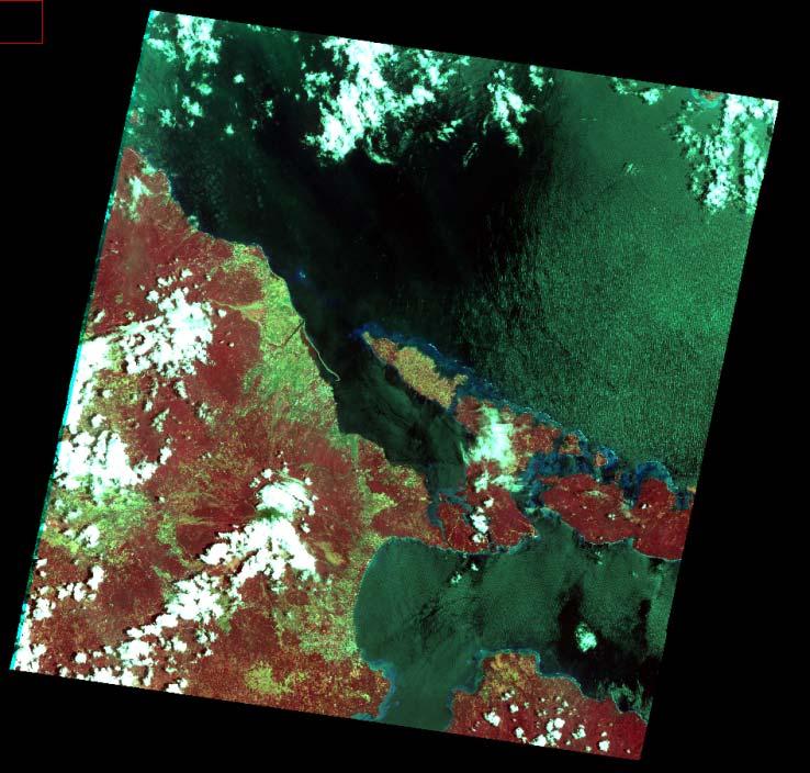
11 Currently Available Data ASTER -04/10/2004, 06/12/2006 ALOS-AVNIR2-03/21/2008 ALOS-PALSAR 01/12/2007, 07/15/2007, 10/17/2008 ALOS-PRISM - 05/04/2007 Training Software ENVI Software Arc GIS Software
")

12 PAN-SHARPENED IMAGE: ALOS PRISM (05/04/2007) & ASTER (06/12/2006) Guinobatan Camalig Yawa River

13 LEGASPI CITY
")

14 PAN-SHARPENED IMAGE: ALOS PRISM (05/04/2007) & ASTER (06/12/2006) National Road Yawa River Daraga

15 ASTER IMAGES 04/10/ /12/2006


16 Image Classification (Preliminary) ASTER - 06/12/2006 Lahar Deposits
 800 700 600 500 400 300 200 100 LAHAR HYDROGRAPH ON SELECTED OUTFLOW POINTS 0 0 50 100 150 200 250 TIME (min) PASIG ABACAN SACOBIA")
 LAHAR HYDROGRAPH 700 600 500 400 300 200 100 0 0 50 100 150 200 250 TIME (min) PASIG ABACAN SACOBIA OBSERVED (PASIG) Sept 16, 1998; Ks: Pf=0.03, NonPf=0.02; Cv=0.")
17 GIS-based Distributed Physical Modeling of Lahar Flows Catchment boundary and drainage density conditions in The boundary of 1991 pyroclastic flow deposit is bounded by white line. LAHAR HYDROGRAPH CELL-BASED PHYSICALLY- BASED MAP DISCHARGE(m 3 /s) LAHAR HYDROGRAPH ON SELECTED OUTFLOW POINTS TIME (min) PASIG ABACAN SACOBIA OBSERVED (PASIG) Sept 16, 1998; Ks: Pf=0.18, NonPf=0.02; Cv=0.2;CW=CW94cut DISCHARGE(m 3 /s) LAHAR HYDROGRAPH TIME (min) PASIG ABACAN SACOBIA OBSERVED (PASIG) Sept 16, 1998; Ks: Pf=0.03, NonPf=0.02; Cv=0.2;CW=CW94cut DISCHARGE(m 3 /s) LAHAR HYDROGRAPH TIME (min) PASIG ABACAN SACOBIA OBSERVED (PASIG) Sept 16, 1998; Ks: Pf=0.06, NonPf=0.02; Cv=0.2;CW=CW94cut DISCHARGE(m 3 /s) LAHAR HYDROGRAPH TIME (min) PASIG ABACAN SACOBIA OBSERVED (PASIG) Sept 16, 1998; Ks: Pf=0.12, NonPf=0.02; Cv=0.2;CW=CW94cut

18 Modeling of Lahars in Mayon Volcano using LAHARZ USGS Open Source Software Steven Schilling

19 ALOS-PRISM - 05/04/2007 NOT TOTALLY CLOUD-FREE Legaspi City
 & SRTM detailed PRISM")
20 PRELIMINARY DEM: ALOS PRISM (05/04/2007) & SRTM detailed PRISM smooth SRTM


21 MINI-PROJECT 3. Modeling of Lahars in Mayon Volcano using LAHARZ ASTER DEM Dec :50K Topo Map


22 Sample LaharZ Run using Different Volumes (2,4,6mcm) Note: some artificial stream piracy due to DEM mosaicking
23 Future Work A more detailed image classification and ground-truth to monitor changes in morphology and landuse using images from JAXA. Collect survey-grade GPS locations (x,y,z) to augment data on DEM generated using ALOS-PRISM Updating of Volcanic Hazard Maps, especially on LAHARS, based on newly acquired images and DEM.


24 PHIVOLCS Technical Training NTT Data Sentinel Asia Training on Remote Sensing February 16 and 19, 2009 PHIVOLCS Conference Room Dr. Ken Tsutsui Dr. Hideaki Nakagawa Resource Speakers P Alanis M Lendio I Narag JB De Ocampo M Cahulogan A Pidlaoan J Nadua C Villanueva A Daag PHIVOLCS PARTICIPANTS
25 Study Site: Antique Province MGB - DENR Implementing Agency for Landslide (induced by Rain)


26 Emergency Request Sentinel Asia System Recent Flood Disaster Kalibo, Aklan (June 21, 2008)

27 Emergency Request Sentinel Asia System Kalibo, Aklan Flood (June 21, 2008) Post-Disaster ALOS-PALSAR JPEG Format Not-georef ALOS-PALSAR Georef with with Topographic Map

28 Emergency Request Sentinel Asia System Kalibo, Aklan Flood (June 21, 2008) This data was used in the actual disaster emergency analysis ACTIVE CHANNEL FLOODED AREA

29 MGB Technical Training NTT Data
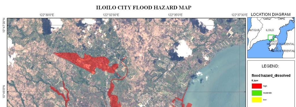
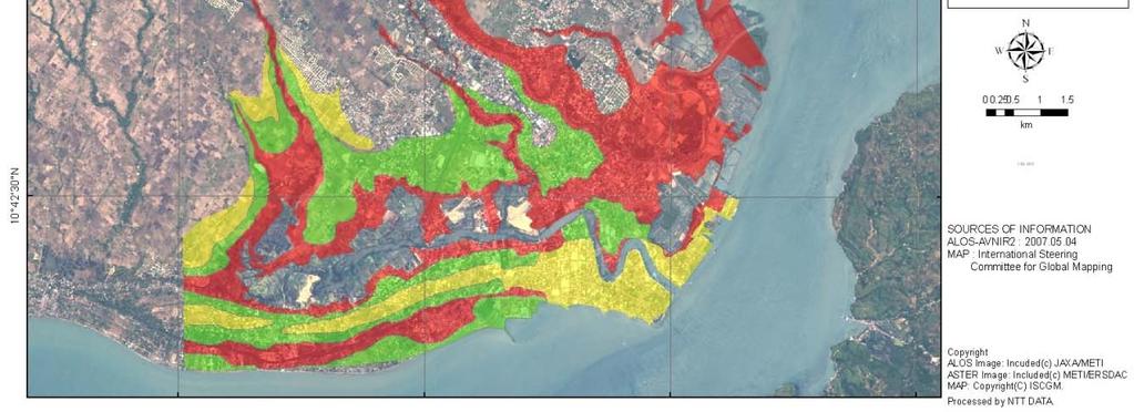
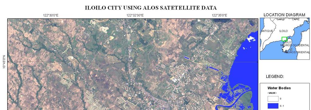
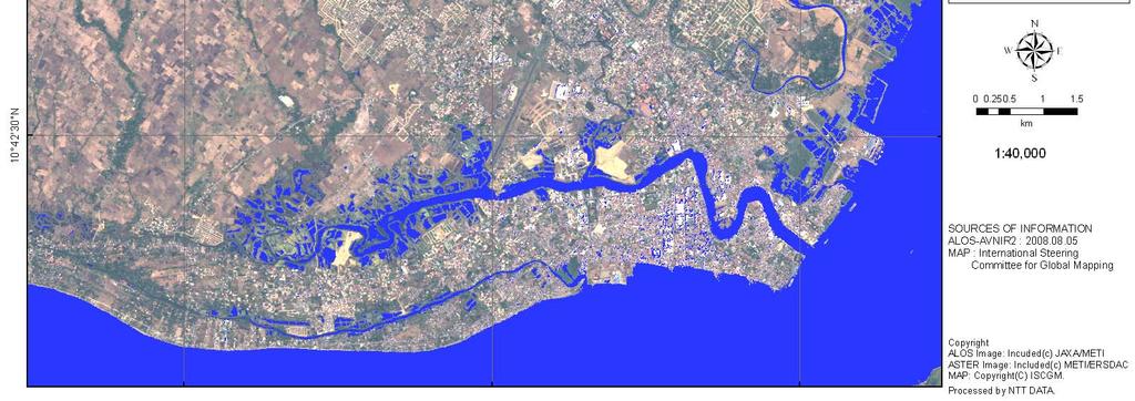
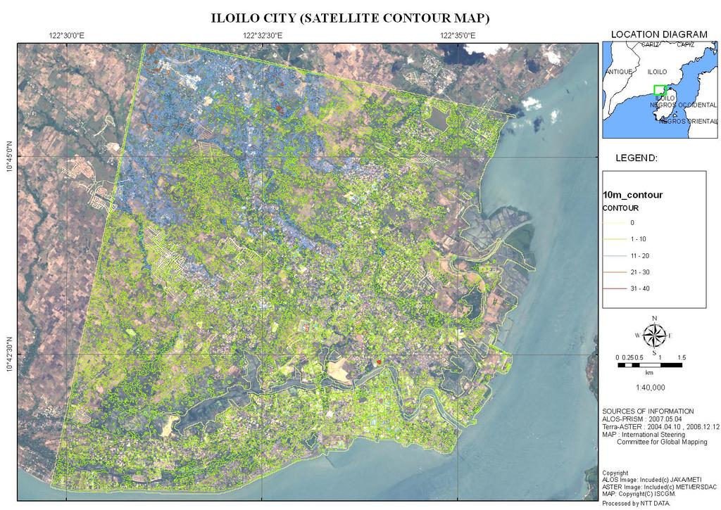
30 Study Site: Iloilo Province PAGASA - DOST Implementing Agency for Flood


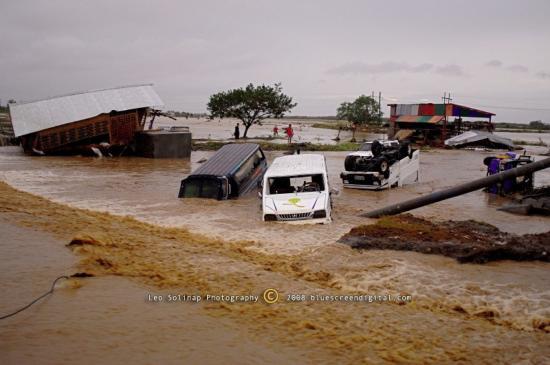
31 Iloilo Flood Typhoon Frank June 21, 2008

32 Typhoon hit Philippines, June 21, 2008
33
34
35

36 PAGASA Technical Training NTT Data
37 Upcoming Activities 1. Technical Training (4days) Image processing ~August Hazard Map Review and DEM/Hazard Map verification in Mayon Volcano ~ Oct Local Workshop in Iloilo Province ~ Nov Project Review ~ Feb 2010
38 THANK YOU VERY FOR YOUR KIND ATTENTION & WE WOULD LIKE TO THANK JAXA FOR THE CONTINOUS SUPPORT OF THIS PROJECT
Progress Report: Sentinel Asia Success Story in the Philippines
 Progress Report: Sentinel Asia Success Story in the Philippines 3 rd Joint Project Team Meeting on the Sentinel Asia STEP-2 July 6-8, 2010 Hyatt Hotel, Manila, Philippines Renato U. Solidum Jr. Director
Contribution of Sentinel Asia Activities to Disaster Management in Asia Pacific Region: Sentinel Asia Success Story in the Philippines Project
 Contribution of Sentinel Asia Activities to Disaster Management in Asia Pacific Region: Sentinel Asia Success Story in the Philippines Project Arturo Daag PHIVOLCS, PHILIPPINES 13 October 2015 Bangkok
Utilization of Satellite for Disaster Management with a Focus on the Sentinel Asia
 2013/01/23 Asian Conference on Reduction 2013 Utilization of Satellite for Management with a Focus on the Sentinel Asia Ichiro NAITO JAXA Space Applications and Promotion Center Management Support Systems
Capacity Building in Applications of Remote Sensing and GIS for Disaster Management
 Capacity Building in Applications of Remote Sensing and GIS for Disaster Management M.K. Hazarika, L. Samarakoon, N. Senevirathne, J.S.M. Fowze and R. de Silva Project Researcher GeoInformatics Center
Sentinel Asia System Operation for Disaster Management in Sri Lanka Major General L.B.R. Mark (Retd) Director General Disaster Management Centre
 Director General Disaster Management Centre") Sentinel Asia System Operation for Disaster Management in Sri Lanka Major General L.B.R. Mark (Retd) Director General Disaster Management Centre Government of Sri Lanka OUTLINE Background Disasters in
Sentinel Asia System Operation for Disaster Management in Sri Lanka Major General L.B.R. Mark (Retd) Director General Disaster Management Centre Government of Sri Lanka OUTLINE Background Disasters in
Overview of Philippine Geohazards Programs
 Overview of Philippine Geohazards Programs 53 rd CCOP Annual Session CCOP-IUGS Task Group on Geohazards Joint Seminar Cebu City, PHILIPPINES October 18, 2017 Renato U. Solidum, Jr. Department of Science
4 th Joint Project Team Meeting for Sentinel Asia 2011
 A Revisit on the Structural Flood Mitigation Measure with the Application of Remote Sensing and GIS in Gin River Basin, Sri Lanka 4 th Joint Project Team Meeting for Sentinel Asia 2011 Geoinformatics Center
Sentinel Asia Data Provider Node Report
 Sentinel Asia Data Provider Node Report Joint Project Team Meeting for Sentinel Asia STEP3 (JPTM2018) 23 24 January 2018, Taipei, Taiwan Yuji TAKADA Space Applications and Operations Center (SAOC) Japan
TYPHOON HAIYAN. Known as typhoon Yolanda in the Philippines. Most powerful storm to make landfall in recorded history
 TYPHOON HAIYAN Known as typhoon Yolanda in the Philippines Most powerful storm to make landfall in recorded history Worst hit provinces: Leyte and Eastern Samar with a combined population of 2.3 M Experienced
LEMBAGA PENERBANGAN DAN ANTARIKSA NASIONAL INDONESIAN NATIONAL INSTITUTE OF AERONAUTICS AND SPACE (LAPAN)
") LEMBAGA PENERBANGAN DAN ANTARIKSA NASIONAL INDONESIAN NATIONAL INSTITUTE OF AERONAUTICS AND SPACE (LAPAN) The Utilization of Remotely Sensed Data to Analyze The Estimated Volume of Pyroclastic Deposits
LEMBAGA PENERBANGAN DAN ANTARIKSA NASIONAL INDONESIAN NATIONAL INSTITUTE OF AERONAUTICS AND SPACE (LAPAN) The Utilization of Remotely Sensed Data to Analyze The Estimated Volume of Pyroclastic Deposits
MARITON V. BORNAS, MSc. Philippine Institute of Volcanology & Seismology C.P. Garcia Ave., Univ. of the Philippines Campus Diliman 1101 Quezon City
 OVERVIEW OF PINATUBO LAHARS & RELATED FLOODING IN CENTRAL LUZON MARITON V. BORNAS, MSc. Philippine Institute of Volcanology & Seismology C.P. Garcia Ave., Univ. of the Philippines Campus Diliman 1101 Quezon
March 2007 The Survey Department of Sri Lanka
 Contribution of Survey Department of Sri Lanka for Mitigation of Disasters in Sri Lanka K.A.U.N.Kasthuri Deputy Surveyor General (Information Technology) March 2007 The Survey Department of Sri Lanka 1
GEOLOGIC HAZARDS AND DISASTER REDUCTION EFFORTS IN THE PHILIPPINES
 GEOLOGIC HAZARDS AND DISASTER REDUCTION EFFORTS IN THE PHILIPPINES 23 rd Asia-Pacific Advanced Network Meeting January 22-26, 2007 Renato U. Solidum Jr Director Philippine Institute of Volcanology and
Establishment of WINDS Ground Station in Sri Lanka. By G.K.D. Amarawardena Additional Secretary Ministry of Disaster Management Sri Lanka
 Establishment of WINDS Ground Station in Sri Lanka By G.K.D. Amarawardena Additional Secretary Ministry of Disaster Management Sri Lanka Contents Background SAS Implementation Progress of WINDS establishment
Georeferencing and Satellite Image Support: Lessons learned, Challenges and Opportunities
 Georeferencing and Satellite Image Support: Lessons learned, Challenges and Opportunities Shirish Ravan shirish.ravan@unoosa.org UN-SPIDER United Nations Office for Outer Space Affairs (UNOOSA) UN-SPIDER
Sentinel Asia Tsunami Working Group
 Sentinel Asia Tsunami Working Group Co-Chairman: Prof. Shunichi Koshimura Abdul Muhari, PhD 4 th Joint Project Team Meeting (JPTM 2017): Sentinel Asia STEP 3 Abdul MUHARI, PhD Ministry of Marine Affairs
10 emergency observation requests were successfully processed during the period
 ISRO s Inputs for the Sentinel Asia DPN and JPT meeting being held during 13-16, 16, November 2012 November 2012 Sentinel Asia Activity Spectrum - A dedicated Sentinel Asia server established at NRSC,
Data Provider Node Report
 Data Provider Node Report March 8, 2017 Joint Project Team Meeting for Sentinel Asia STEP3 (JPTM2017) Hani, Vietnam Yuji Takada Space Application and Operations Center Japan Aerospace Exploration Agency
AND THE COOPERATION WITH SENTINEL ASIA FOR DISASTER MANAGEMENT
 Ministry of Natural resources and Environment National Remote Sensing DEpartment NATIONAL REMOTE SENSING DEPARTMENT (NRSD) AND THE COOPERATION WITH SENTINEL ASIA FOR DISASTER MANAGEMENT By: Dr. Chu Hai
KARI Activation for the International Disasters
 KARI Activation for the International Disasters 5 th Joint Project Team Meeting for Sentinel Asia STEP2 (JPTM2012) 14 th Nov 2012 Boyeol Yoon Senior Researcher, Satellite Information Research Center (SIRC)
The Third UN-GGIM-AP Plenary Meeting. Use of Geospatial Information in Disaster and Coordination among NDMA and Relevant Organizations/Stakeholders
 The Third UN-GGIM-AP Plenary Meeting Use of Geospatial Information in Disaster and Coordination among NDMA and Relevant Organizations/Stakeholders Bali Indonesia 10 November 2014 Bernardus Wisnu Widjaja
EXTRACTION OF FLOODED AREAS DUE THE 2015 KANTO-TOHOKU HEAVY RAINFALL IN JAPAN USING PALSAR-2 IMAGES
 EXTRACTION OF FLOODED AREAS DUE THE 2015 KANTO-TOHOKU HEAVY RAINFALL IN JAPAN USING PALSAR-2 IMAGES F. Yamazaki a, *, W. Liu a a Chiba University, Graduate School of Engineering, Chiba 263-8522, Japan
Tectonic Processes and Hazards Enquiry Question 1: Why are some locations more at risk from tectonic hazards?
 Tectonic Processes and Hazards Enquiry Question 1: Why are some locations more at risk from tectonic hazards? Key words Basalt Andesite Rhyolite Benioff Zone Subduction zone Crustal fracturing Definition
Applying Hazard Maps to Urban Planning
 Applying Hazard Maps to Urban Planning September 10th, 2014 SAKAI Yuko Disaster Management Expert JICA Study Team for the Metro Cebu Roadmap Study on the Sustainable Urban Development 1 Contents 1. Outline
Word Cards. 2 map. 1 geographic representation. a description or portrayal of the Earth or parts of the Earth. a visual representation of an area
 Name: Date: Hour: Word Cards 1 geographic representation a description or portrayal of the Earth or parts of the Earth Example: A map is a representation of an actual location or place. 2 map a visual
Philippines NSDI Foundation Data Program. Andrew Bashfield
 Philippines NSDI Foundation Data Program Andrew Bashfield 1 Overview Part 1: Building the NSDI Framework Part 2: Collecting Foundation Datasets 2 Building the NSDI Framework Background & NDSI Overview
Satellite-based applications for water resources management in Asia and Pacific region
 Satellite-based applications for water resources management in Asia and Pacific region Ko Hamamoto Japan Aerospace Exploration Agency The views expressed in this paper/presentation are the views of the
DIPLOMA IN DISASTER MANAGEMENT. (Non-Semester) (With effect from the academic year )
 (With effect from the academic year )") DIPLOMA IN DISASTER MANAGEMENT (Non-Semester) (With effect from the academic year 2013-14) Eligibility for the Course Candidate should have passed the Higher Secondary Examination conducted by the Board
DIPLOMA IN DISASTER MANAGEMENT (Non-Semester) (With effect from the academic year 2013-14) Eligibility for the Course Candidate should have passed the Higher Secondary Examination conducted by the Board
NGIAs' roles in successful disaster response
 The Second UN-GGIM-AP Plenary Meeting NGIAs' roles in successful disaster response Japan Teheran Iran 28 October 2013 Shin-ichi SAKABE, Director of International Affairs Division Geospatial Information
DAMAGE DETECTION OF THE 2008 SICHUAN, CHINA EARTHQUAKE FROM ALOS OPTICAL IMAGES
 DAMAGE DETECTION OF THE 2008 SICHUAN, CHINA EARTHQUAKE FROM ALOS OPTICAL IMAGES Wen Liu, Fumio Yamazaki Department of Urban Environment Systems, Graduate School of Engineering, Chiba University, 1-33,
Roles of NGII in successful disaster management
 The Second UN-GGIM-AP Plenary Meeting Roles of NGII in successful disaster management Republic of Korea Teheran Iran 28 October 2013 Sanghoon Lee, Ph.D. NGII Outline Type of Disasters Occur in Korea Practical
JCOMM-CHy Coastal Inundation Forecasting Demonstration Project (CIFDP)
") WMO World Meteorological Organization Working together in weather, climate and water JCOMM-CHy Coastal Inundation Forecasting Demonstration Project (CIFDP) Coastal Flooding & Vulnerable Populations Coastal
WMO World Meteorological Organization Working together in weather, climate and water JCOMM-CHy Coastal Inundation Forecasting Demonstration Project (CIFDP) Coastal Flooding & Vulnerable Populations Coastal
Progress Report. Flood Hazard Mapping in Thailand
 Progress Report Flood Hazard Mapping in Thailand Prepared By: Mr. PAITOON NAKTAE Chief of Safety Standard sub-beuro Disaster Prevention beuro Department of Disaster Prevention and Mitigation THAILAND E-mail:
Australia Government Geospatial Capacity Building Efforts in Asia and the Pacific. Dr John Dawson
 Australia Government Geospatial Capacity Building Efforts in Asia and the Pacific Dr John Dawson Presentation Overview About Geoscience Australia Examples of Geospatial Capacity Building Activity Geodesy
CEOS Overview and JAXA Plans for Water Cycle Observation
 CEOS Overview and JAXA Plans for Water Cycle Observation Asian Water Cycle Symposium November 2-4, 2005 Tokyo, Japan Chu Ishida Japan Aerospace Exploration Agency (JAXA) Contents 1. CEOS overview 2. CEOS
Applied Geoscience and Technology Division SOPAC. Joy Papao, Risk Information Systems Officer
 Joy Papao, Risk Information Systems Officer Secretariat of the Pacific Community SPC 22 Pacific Island States Head office in Noumea, New Caledonia 2 Regional offices (Pohnpei and Honiara) 600 staff 9 Technical
EMERGENCY PLANNING IN NORTHERN ALGERIA BASED ON REMOTE SENSING DATA IN RESPECT TO TSUNAMI HAZARD PREPAREDNESS
 EMERGENCY PLANNING IN NORTHERN ALGERIA BASED ON REMOTE SENSING DATA IN RESPECT TO TSUNAMI HAZARD PREPAREDNESS Barbara Theilen-Willige Technical University of Berlin, Institute of Applied Geosciences Department
Report of the Working Group 2 Data Sharing and Integration for Disaster Management *
 UNITED NATIONS E/CONF.104/6 ECONOMIC AND SOCIAL COUNCIL Twentieth United Nations Regional Cartographic Conference for Asia and the Pacific Jeju, 6-9 October 2015 Item 5 of the provisional agenda Report
Abdolreza Ansari Amoli. Remote Sensing Department Iranian Space Agency
 Risk Assessment and Mapping Using Earth Observation Data In Iran Abdolreza Ansari Amoli Remote Sensing & GIS Expert Remote Sensing Department Iranian Space Agency Different Types of Disasters in Iran Epidemic
GEO-VIII November Geohazard Supersites and Natural Laboratories Progress Report. Document 9
 GEO-VIII 16-17 November 2011 Geohazard Supersites and Natural Laboratories Progress Report Document 9 This document is submitted to GEO-VIII for information. Geohazard Supersites and Natural Laboratories
Effective Utilization of Synthetic Aperture Radar (SAR) Imagery in Rapid Damage Assessment
 Imagery in Rapid Damage Assessment") Effective Utilization of Synthetic Aperture Radar (SAR) Imagery in Rapid Damage Assessment Case Study Pakistan Floods SUPARCO M. Maisam Raza, Ahmad H. Rabbani SEQUENCE Flood Monitoring using Satellite
Effective Utilization of Synthetic Aperture Radar (SAR) Imagery in Rapid Damage Assessment Case Study Pakistan Floods SUPARCO M. Maisam Raza, Ahmad H. Rabbani SEQUENCE Flood Monitoring using Satellite
Crowdsourcing approach for large scale mapping of built-up land
 Crowdsourcing approach for large scale mapping of built-up land Kavinda Gunasekara Kavinda@ait.asia Geoinformatics Center Asian Institute of Technology, Thailand. Regional expert workshop on land accounting
Final Presentation on Disaster Risk Management in Japan. Through ADRC V. R Programme. Main Findings and Action Plan:
 Final Presentation on Disaster Risk Management in Japan Through ADRC V. R Programme Main Findings and Action Plan: Problem/Hazard and Disaster in Japan Good Practiced on Disaster Risk Management in Japan
JICA s Experiences of Connecting Japanese Science & Technologies for Disaster Risk Reduction in Developing Countries
 JICA s Experiences of Connecting Japanese Science & Technologies for Disaster Risk Reduction in Developing Countries Junji WAKUI Deputy Director General, Group Leader Disaster Risk Reduction Group Global
Community-Based Flood Early Warning System (CBFEWS)
") Community-Based Flood Early Warning System (CBFEWS) Prepared by: Eng r. Hilario G. Esperanza Eng r.. Socrates F. Paat,, Jr. Flood Forecasting Branch PAGASA Weather Bureau Department of Science and Technology
Community-Based Flood Early Warning System (CBFEWS) Prepared by: Eng r. Hilario G. Esperanza Eng r.. Socrates F. Paat,, Jr. Flood Forecasting Branch PAGASA Weather Bureau Department of Science and Technology
RESAP Progress Report
 RESAP Progress Report December 2016 to October 2017 Presentation to the Twenty-first session of the Intergovernmental Consultative Committee on the Regional Space Applications Programme for Sustainable
SPACE TECHNOLOGY INSTITUTE, VNREDSat-1 and DATA PROVIDER NODE (DPN) REPORT
 REPORT") 4th Joint Project Team Meeting for Sentinel Asia STEP3 (JPTM2017) 8-9 March 2017 SPACE TECHNOLOGY INSTITUTE, VNREDSat-1 and DATA PROVIDER NODE (DPN) REPORT www.sti.vast.ac.vn CONTENT 1. Overview of Space
4th Joint Project Team Meeting for Sentinel Asia STEP3 (JPTM2017) 8-9 March 2017 SPACE TECHNOLOGY INSTITUTE, VNREDSat-1 and DATA PROVIDER NODE (DPN) REPORT www.sti.vast.ac.vn CONTENT 1. Overview of Space
Disaster Management and Spatial Data An Experience of Sri Lanka for Joint project team meeting 2012
 Disaster Management and Spatial Data An Experience of Sri Lanka for Joint project team meeting 2012 1 by Padma Kumara Withana Provincial Surveyor General Uva Province 2 Out line ü Introduction ü Natural
held on 4 June 2013 Prof. Yoshimori Honkura, Program Officer of Japan Science and Technology Agency (JST) Jakarta, Indonesia Pan Pacific Hotel)
 Jakarta, Indonesia Pan Pacific Hotel)") Overview of the Outcomes from e-asia JRP Disaster Prevention Workshop held on 4 June 2013 Prof. Yoshimori Honkura, Program Officer of Japan Science and Technology Agency (JST) Jakarta, Indonesia (@Sari
Overview of the Outcomes from e-asia JRP Disaster Prevention Workshop held on 4 June 2013 Prof. Yoshimori Honkura, Program Officer of Japan Science and Technology Agency (JST) Jakarta, Indonesia (@Sari
Developing fragility functions for tsunami damage estimation using the numerical model and satellite imagery
 Developing fragility functions for tsunami damage estimation using the numerical model and satellite imagery Shunichi KOSHIMURA 1 and Hideaki YANAGISAWA 2 1 Associate Professor, Disaster Control Research
Contribution to global Earth observation from satellites
 Contribution to global Earth observation from satellites - JAXA s Earth Observation strategy - April 16, 2008 Makoto Kajii Japan Aerospace Exploration Agency Earth Observation Summits and GEOSS 1 st EO
Table ronde 5 : Cartographie d'urgence Emergency Mapping.
 Table ronde 5 : Cartographie d'urgence Emergency Mapping MapAction is an international NGO that provides maps and other information services to help humanitarian relief organisations in the field MapAction
GENERAL. CHAPTER 1 BACKGROUND AND PURPOSE OF THE GUIDELINES Background of the Guidelines Purpose of the Guidelines...
 GENERAL CHAPTER 1 BACKGROUND AND PURPOSE OF THE GUIDELINES... 1 1.1 Background of the Guidelines... 1 1.2 Purpose of the Guidelines... 3 CHAPTER 2 APPLICATION OF THE GUIDELINES... 3 2.1 Potential Users
Juban is faced with several major, major,major,major, major Natural Disasters and Hazards..
 Juban Hazards Juban Disaster Risk Reduction and Management Council (JMDRRMC) Juban Hazard Profile Juban is faced with natural multigeohazards / disasters. >>> Typhoons / Floods Bicol Region typhoon belt
THE FIRST EXPERIENCE OF USING ALOS DATA FOR DISASTER MONITORING
 THE FIRST EXPERIENCE OF USING ALOS DATA FOR DISASTER MONITORING Dr. Nguyen Dinh Duong, IG, VAST Dr. Nguyen Xuan Lam, RSC, MONRE Dr. Hoang Minh Hien,, DMU, MARD Contents The Xangsane Typhoon Acquisition
Geo-information and Disaster Risk Reduction in the Hindu Kush-Himalayan region
 Geo-information and Disaster Risk Reduction in the Hindu Kush-Himalayan region Basanta Shrestha, Division Head MENRIS, International Centre for Integrated Mountain Development Kathmandu, Nepal The International
New A-Level Physical Geography
 Half Term 1 3.1 Physical Geography: 3.1.5 Hazards: Plate Tectonics This optional section of our specification focuses on the lithosphere and the atmosphere, which intermittently but regularly present natural
Integrated and Multi-Hazard Disaster Management
 GeoSmart Asia 2016: GI for Disaster Preparedness and Risk Reduction Bandung, Indonesia 12 October 2016 Integrated and Multi-Hazard Disaster Management Lim Choun Sian & Nurfashareena Muhamad Centre for
National Disaster Management Centre (NDMC) Republic of Maldives. Location
 Republic of Maldives. Location") National Disaster Management Centre (NDMC) Republic of Maldives Location Country Profile 1,190 islands. 198 Inhabited Islands. Total land area 300 sq km Islands range b/w 0.2 5 sq km Population approx.
National Disaster Management Centre (NDMC) Republic of Maldives Location Country Profile 1,190 islands. 198 Inhabited Islands. Total land area 300 sq km Islands range b/w 0.2 5 sq km Population approx.
PAGASA s Expectations of New-generation Satellites for Hazard Monitoring
 Country Report Philippines PAGASA s Expectations of New-generation Satellites for Hazard Monitoring VICENTE P. PALCON, JR. (Assistant Weather Services Chief) Weather Division- PAGASA DOST Email: vppalconjr@pagasa.dost.gov.ph
SEISMIC RISK ASSESSMENT IN ARMENIA
 SEISMIC RISK ASSESSMENT IN ARMENIA Hovhannes Khangeldyan Head of National Crisis Management Center Rescue Service Ministry of Emergency Situations of the Republic of Armenia Tokyo, 2016 ARMENIA: GEOGRAPHICAL
Trends of Natural Disasters in the Asia- Pacific Region and the Direction of Disaster Management
 2016 APEC SCCC, Arequipa, Peru Session 6 - Human Security: Food, Health, Natural Disasters and Environmental Issues Trends of Natural Disasters in the Asia- Pacific Region and the Direction of Disaster
GLIDE: Global Unique Disaster Identifier for Effective Sharing of Disaster Information
 2018/SOM1/EPWG/023 Agenda Item: 12.1 GLIDE: Global Unique Disaster Identifier for Effective Sharing of Disaster Information Purpose: Information Submitted by: Japan 13 th Emergency Preparedness Working
CHALLENGES ON SEDIMENT- RELATED DISASTER MITIGATION
 CHALLENGES ON SEDIMENT- RELATED DISASTER MITIGATION Dolores M. Hipolito Project Manager II DPWH, PMO-FCSEC Types of Sediment-Related Disasters A. Direct Disaster Debris flows Landslides Slope failures
Uses of free satellite imagery for Disaster Risk Reduction (DRR)
") Centre of Applied Geoscience, Disaster Risk Reduction Research Group, School of Earth and Environmental Science, University of Portsmouth, UK Uses of free satellite imagery for Disaster Risk Reduction
Centre of Applied Geoscience, Disaster Risk Reduction Research Group, School of Earth and Environmental Science, University of Portsmouth, UK Uses of free satellite imagery for Disaster Risk Reduction
Current tsunami research activities in the Philippines
 DOST PHIVOLCS Current tsunami research activities in the Philippines Graciano P. Yumul, Jr. 1,2, Carla B. Dimalanta 1 and Bart Bautista 3 1 National Institute of Geological Sciences, University of the
APEC Research Center for Typhoon and Society (ACTS) 2013 Activity Plan: Asia-Pacific Weather Radar Data Exchange and Network for Landfall Typhoons
 2013 Activity Plan: Asia-Pacific Weather Radar Data Exchange and Network for Landfall Typhoons") 01/ISTWG/01 Agenda Item: Sub Group D APEC Research Center for Typhoon and Society (ACTS) 01 Activity Plan: Asia-Pacific Weather Radar Data Exchange and Network for Landfall Typhoons Purpose: Information
01/ISTWG/01 Agenda Item: Sub Group D APEC Research Center for Typhoon and Society (ACTS) 01 Activity Plan: Asia-Pacific Weather Radar Data Exchange and Network for Landfall Typhoons Purpose: Information
Disaster Management in Republic of Korea
 The Third UN-GGIM-AP Plenary Meeting Disaster Management in Republic of Korea ~Coordination among NGIA & Other Related Organizations and Recommendations~ Bali Indonesia 10 November 2014 Sanghoon Lee, Ph.D.
The challenge of risk communication how risk communication is the key to triggering action: Experiences from the Philippines and PNG
 The challenge of risk communication how risk communication is the key to triggering action: Experiences from the Philippines and PNG Dr Andrew Jones on behalf of the Regional Development Group and partners
PROFILING OF MAJOR RIVER SYSTEMS AROUND MAYON VOLCANO USING AIRSAR IMAGES
 PROFILING OF MAJOR RIVER SYSTEMS AROUND MAYON VOLCANO USING AIRSAR IMAGES Rowena B. QUIAMBAO, Ronnie C. Torres Philippine Institute of Volcanology & Seismology C.P. Garcia Street, University of the Philippines
GEO Geohazards Community of Practice
 GEO Geohazards Community of Practice 1) Co-Chair of GHCP With input from: Stuart Marsh, GHCP Co-Chair Francesco Gaetani, GEO Secretariat and many GHCP contributors 1) Nevada Bureau of Mines and Geology
FLOOD HAZARD MAPPING OF DHAKA-NARAYANGANJ-DEMRA (DND) PROJECT USING GEO-INFORMATICS TOOLS
 PROJECT USING GEO-INFORMATICS TOOLS") FLOOD HAZARD MAPPING OF DHAKA-NARAYANGANJ-DEMRA (DND) PROJECT USING GEO-INFORMATICS TOOLS Md. Aminul Islam MEE07178 Supervisor: Prof. Kuniyoshi TAKEUCHI ABSTRACT Dhaka-Narayanganj-Demra (DND) Project is
FLOOD HAZARD MAPPING OF DHAKA-NARAYANGANJ-DEMRA (DND) PROJECT USING GEO-INFORMATICS TOOLS Md. Aminul Islam MEE07178 Supervisor: Prof. Kuniyoshi TAKEUCHI ABSTRACT Dhaka-Narayanganj-Demra (DND) Project is
Space Applications for Disaster Risk Reduction and Sustainable Development
 Space Applications for Disaster Risk Reduction and Sustainable Development Space Applications Section (SAS) ICT and Disaster Risk Reduction Division (IDD) UNESCAP Contents I. RESAP Activities 2016-2017
Application of a GIS for Earthquake Hazard Assessment and Risk Mitigation in Vietnam
 Application of a GIS for Earthquake Hazard Assessment and Risk Mitigation in Vietnam Nguyen Hong Phuong Earthquake Information and Tsunami Warning Centre, VAST OUTLINE Introduction Fault Source Model and
- facilitate the preparation of landslide inventory and landslide hazard zonation maps for the city, - development of precipitation thresholds,
 Date of Submission 29.03.2012 IPL Project Proposal Form 2012 (MAXIMUM: 3 PAGES IN LENGTH) 1. Project Title: (2 lines maximum)-introducing Community-based Early Warning System for Landslide Hazard Management
River Response. Sediment Water Wood. Confinement. Bank material. Channel morphology. Valley slope. Riparian vegetation.
 River Response River Response Sediment Water Wood Confinement Valley slope Channel morphology Bank material Flow obstructions Riparian vegetation climate catchment vegetation hydrological regime channel
Hazardous Weather and Flooding Preparedness. Hazardous Weather and Flooding Preparedness
 Hazardous Weather and Flooding Preparedness 1 A Cooperative Effort 2 Administrative Information Emergency exits and procedures Location of restrooms Mobile devices Procedure for questions Course materials
Theme 4. Disaster Mitigation and Risk Management
 Theme 4 Disaster Mitigation and Risk Management World Flood Map in 2002 Released by WMO as of August 29 Over 17 million were affected (in more than 80 countries) 3,000 were killed Total damage of over
RiskCity Training package on the Application of GIS for multi- hazard risk assessment in an urban environment.
 RiskCity Training package on the Application of GIS for multi- hazard risk assessment in an urban environment. Cees van Westen (Westen@itc.nl) & Nanette C. Kingma (Kingma@itc.nl) ITC: Training & Research
Bhutan Country Report for JPTM 2010 (July, 2010) Department of Disaster Management Ministry of Home & Cultural Affairs Royal Government of Bhutan
 Department of Disaster Management Ministry of Home & Cultural Affairs Royal Government of Bhutan") Bhutan Country Report for JPTM 2010 (July, 2010) Department of Disaster Management Ministry of Home & Cultural Affairs Royal Government of Bhutan 1 Contents of Presentation 1. Disaster Hazards and Underlying
Bhutan Country Report for JPTM 2010 (July, 2010) Department of Disaster Management Ministry of Home & Cultural Affairs Royal Government of Bhutan 1 Contents of Presentation 1. Disaster Hazards and Underlying
Copernicus Overview. Major Emergency Management Conference Athlone 2017
 Copernicus Overview Major Emergency Management Conference Athlone 2017 Copernicus is a European programme implemented by the European Commission. The services address six thematic areas: land, marine,
International Symposium on Earthquake & Tsunami Disaster Reduction, March 14-15, 2012, Sendai, Japan
 International Symposium on Earthquake & Tsunami Disaster Reduction, March 14-15, 2012, Sendai, Japan E h Enhancement t off earthquake th k and d volcano monitoringg in the Philippines: Progress report
Satellite Remote Sensing for Ocean
 Satellite Remote Sensing for Ocean August 17, 2017 Masatoshi Kamei RESTEC All rights reserved RESTEC 2015 Contents 1. About RESTEC and Remote Sensing 2. Example of Remote Sensing Technology 3. Remote Sensing
DRRM in the Philippines: DRRM Projects, Geoportals and Socio-Economic Integration
 Regional workshop on Geo-referenced information system for improving disaster risk preparedness and management in Asia and the Pacific 26-27 June 2014, UNCC, Bangkok, Thailand DRRM in the Philippines:
Sediment Disasters and Mass Movement (SD&M 2 ) NATIONAL DISASTER MANAGEMENT RESEARCH INSTITUTE
 NATIONAL DISASTER MANAGEMENT RESEARCH INSTITUTE") Sediment Disasters and Mass Movement (SD&M 2 ) Contents Outline of SD&M 2 Major outcomes Issues and conclusions Prologue Mass movement in Ulsan, Korea by Typhoon CHABA on Oct. 5. Outline of SD&M 2 Activities
Sediment Disasters and Mass Movement (SD&M 2 ) Contents Outline of SD&M 2 Major outcomes Issues and conclusions Prologue Mass movement in Ulsan, Korea by Typhoon CHABA on Oct. 5. Outline of SD&M 2 Activities
Report. Developing a course component on disaster management
 Report Developing a course component on disaster management By Chira Prangkio Tawee Chaipimonplin Department of Geography, Faculty of Social Sciences, Chiang Mai University Thailand Presented at Indian
What Are Disasters? The Rescue Kids Trio!
 The Rescue Kids Trio! What Are Disasters? This manual was made possible through funding by the Council of Local Authorities for International Relations. Disasters and emergency preparedness Emergency preparedness
ABSTRACT. Keywords: Flood hazard mapping, hydro-geomorphic method, hydrologic modelling method, return period, rainfall runoff inundation.
 EVALUATION OF FLOOD-PRONE AREAS IN BICOL RIVER BASIN, PHILIPPINES: COMPARISON OF FLOOD HAZARD MAPPING USING HYDRO- GEOMORPHIC AND HYDROLOGIC MODELLING METHODS Emar Guevara Basilan MEE13630 Supervisor:
INDONESIA IMPACT BASED FORECAST PROGRAM
 INDONESIA IMPACT BASED FORECAST PROGRAM Seoul, 19-21 November 2018 The 2nd Regional Workshop on Impact-based Forecasts in Asia Indonesia Agency for Meteorology Climatology and Geophysics (BMKG) A. Fachri
Development of Global Map for GEOSS SBAs US-09-03a
 Development of Global Map for GEOSS SBAs US-09-03a UIC User Engagement Session 2 November, 2010 Yoshikazu FUKUSHIMA Secretariat General of International Steering Committee for Global Mapping Geospatial
Development of the Kingdom of Tonga Cyclone Emergency Recovery and Management System using Geospatial Tools
 Development of the Kingdom of Tonga Cyclone Emergency Recovery and Management System using Geospatial Tools Case Studies from Small Island States FIG Commissions 3, 7 and 8 Malcolm Archbold General Manager
Capacity Building Activities at CRECTEALC. Ing. Jerjes Molina Blancas Professor and Developer.
 Capacity Building Activities at CRECTEALC Ing. Jerjes Molina Blancas Professor and Developer. Centro Regional de Enseñanza de Ciencia y Tecnología del Espacio para América Latina y el Caribe (CRECTEALC)
Report of PCGIAP to the 18 th United Nations Regional Cartographic Conference for Asia and the Pacific (UNRCC-AP) for the period
 for the period") Permanent Committee on GIS Infrastructure for Asia and the Pacific (PCGIAP) Established in 1995 by a United Nations Resolution Report of PCGIAP to the 18 th United Nations Regional Cartographic Conference
Permanent Committee on GIS Infrastructure for Asia and the Pacific (PCGIAP) Established in 1995 by a United Nations Resolution Report of PCGIAP to the 18 th United Nations Regional Cartographic Conference
Spatial Planning Platform Meeting
 Spatial Planning Platform Meeting August 1 st 2018 Part II Session 1 Design and Implementation of National and Regional Planning for Inclusive Growth Spatial info from space based technologies RESTEC (Remote
Coastal Inundation Forecasting Demonstration Project CIFDP. Flood Forecasting Initiative-Advisory Group (FFI-AG 3), Geneva, 5-7 Dec, 2017
, Geneva, 5-7 Dec, 2017") Coastal Inundation Forecasting Demonstration Project CIFDP Flood Forecasting Initiative-Advisory Group (FFI-AG 3), Geneva, 5-7 Dec, 2017 Coastal Flooding & Vulnerable Populations Coastal populations are
Coastal Inundation Forecasting Demonstration Project CIFDP Flood Forecasting Initiative-Advisory Group (FFI-AG 3), Geneva, 5-7 Dec, 2017 Coastal Flooding & Vulnerable Populations Coastal populations are
GEOMATICS. Shaping our world. A company of
 GEOMATICS Shaping our world A company of OUR EXPERTISE Geomatics Geomatics plays a mayor role in hydropower, land and water resources, urban development, transport & mobility, renewable energy, and infrastructure
Mapping Coastal Change Using LiDAR and Multispectral Imagery
 Mapping Coastal Change Using LiDAR and Multispectral Imagery Contributor: Patrick Collins, Technical Solutions Engineer Presented by TABLE OF CONTENTS Introduction... 1 Coastal Change... 1 Mapping Coastal
Global Map: A Tool for Disaster Mitigation for the Asia and Pacific Region
 Global Map: A Tool for Disaster Mitigation for the Asia and Pacific Region D. R. Fraser Taylor Chair, International Steering Committee for Global Mapping (ISCGM) fraser_taylor@carleton.ca www. 18 th United
DAGUPAN CITY EXPERIENCES, GOOD PRACTICES, CHALLENGES AND LESSONS LEARNED ON DISASTER RISK MANAGEMENT
 DAGUPAN CITY EXPERIENCES, GOOD PRACTICES, CHALLENGES AND LESSONS LEARNED ON DISASTER RISK MANAGEMENT Reducing Vulnerability to Climate Change Impacts and Related Natural Disasters in East Asia 12 and 13
Outline of Guideline for Development and Utilization of Tsunami Disaster Management Map
 Outline of Guideline for Development and Utilization of Tsunami Disaster Management Map Port and Airport Research Institute, Japan The Overseas Coastal Area Development Institute of Japan Ports and Harbours