Enabling Access to Arctic Location Based Information
|
|
|
- Kristina Byrd
- 5 years ago
- Views:
Transcription
1 Enabling Access to Arctic Location Based Information Jani Kylmäaho Arctic SDI Geoportal WG Lead National Land Survey of Finland INSPIRE Conference 29 September 2016

2 bear/polar bear on ice.jpg 2


3 3 g
4 4
5 5

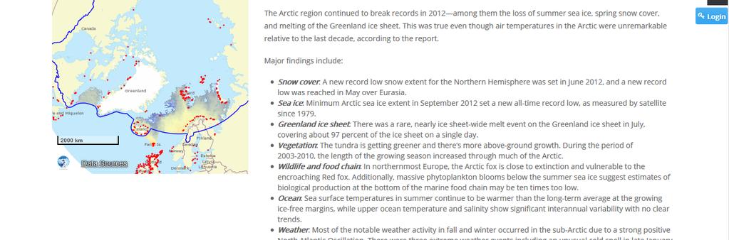
6 Improve access to reliable data for Monitoring, Management, Emergency preparedness and Decision making in the Arctic 6
7 Participating Countries Canada Norway Finland Russia Denmark Sweden USA Iceland USGS, Chair NLS FI, Chair
8 A Brief History of the Arctic SDI a voluntary collaboration of the 8 Arctic National Mapping Agencies since s: Git Barents 2007: First Arctic SDI Roadmap : Arctic Council SAOs endorse the Arctic SDI initiative : Project plan approved Kick off Technical Working Group 2014: Geoportal Launched MOU between the Arctic countries to develop an SDI 2015: 5 year Strategic Plan and Governance established 2016 and forward: Improved Geoportal Pan Arctic DEM OGC Pilot Increased outreach Stakeholder Documentation & User Guides Arctic SDI: The Results of Collaborative Efforts Maturing of the Arctic SDI 8


9 A Collaborative Model in the Arctic SDI Working with stakeholder organizations to make their key data available, with a focus on the Arctic Council Understanding the needs and requirements of stakeholders Information Management best practices (lifecycle of geospatial data) Open standards and interoperability Helping data contributors and users understand how to participate Graphic Source: OGC 9


10 Arctic Council Working Groups 10

11 Capacity Building SDI Manual for the Arctic with guidelines & practices for Data management and sharing SDI development Standardization guidelines Efficient monitoring and decision making Key Performance Indicators Evaluation once in two years 11
 Arctic Spatial Data")


12 Open Geospatial Consortium (OGC) Arctic Spatial Data Pilot Climate Change Scenarios Scenario based video how to break down information silos improve access to reliable data for monitoring, management, emergency preparedness and decision making in the Arctic Address Arctic specific issues, like zero/low bandwidth Increase awareness of Arctic SDI 12


13 Technical Support Assisting CAFF WGs with use their thematic data MODIS satellite data derived products: Vegetation Indices (incl. NDVI) Land Cover Type Snow Covered Area Sea Surface Temperature (SST) Marine Chlorophyll a 2012 Land Cover Type Land Surface Temperature Time Series Migratory Bird Index Sea Surface Temperature 13


14 Data Resources Pan Arctic Digital Elevation Map Marine Data Gazetteer Database and Search Arctic Reference Basemap Pan Arctic DEM Gazetteer search 14 Shaded relief for depths


15 Authoritative Reference Basemap Provided Directly from the 8 Arctic National Mapping Agencies Common Cartographic Specification A Trusted Source of Detailed Information Southern Svalbard: Arctic SDI Basemap vs. Google Maps


16 Arctic SDI Geoportal 16

17 Embedded Maps 17
18 Oskari Geoportal for ASDI and INSPIRE Open Source Framework for Geoportals Easy to use tools for using Distributed SDI s like INSPIRE, European Location Framework ELF, Arctic SDI Built in access to WFS 2.0 API s with Complex Schemas Embedded Maps Tool and Integration API like Google maps with rich SDI content Time Series Data Visualization Thematic Mapping with Statistical Information 18


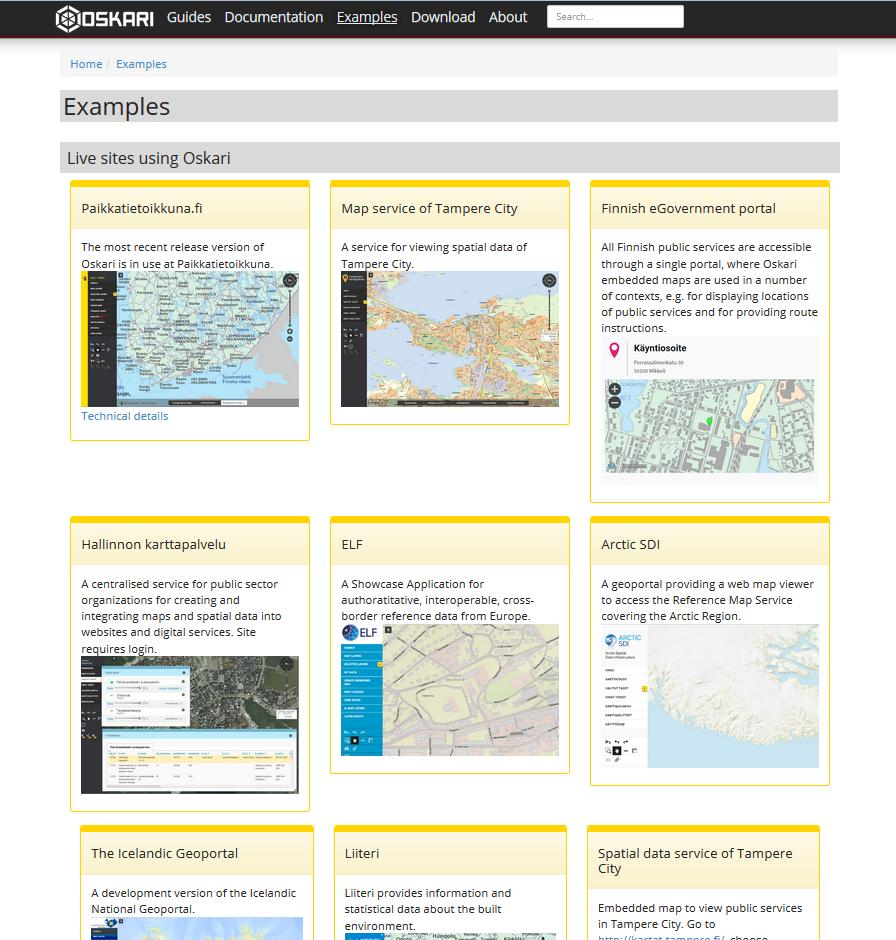
19 Other Oskari Examples 19
20 Comparison of INSPIRE and Arctic SDI Regulated 28 member states Users: European Commission, others? Harmonized data models, schemas Interoperability via Implementation Rules and Technical Guidance Voluntary collaboration 8 national mapping agencies Users: Arctic Council Working Groups (for a start) No harmonization of data apart from Cartographic Specificaton for Arctic Basemap Interoperability via plain OGC/ISO and ASDI Manual 20


21 Arctic SDI Video on YouTube Arctic SDI Fact Sheet Information on Oskari

22 arctic sdi.org geoportal.arctic sdi.org oskari.org 22
Enabling Access to Arctic Location Based Information
 Enabling Access to Arctic Location Based Information Kevin Gallagher Arctic SDI Board Chair, United States Geological Survey Alaska Surveying and Mapping Conference, GeoJam 15 February 2017 What is Arctic
Enabling Access to Arctic Location Based Information - the Arctic SDI
 Enabling Access to Arctic Location Based Information - the Arctic SDI Jani Kylmäaho Head of Arctic SDI Geoportal WG National Land Survey of Finland SAO Chair, WG Chairs and Executive Secretaries meeting
Arctic Spatial Data Infrastructure Enabling Access to Arctic Location-Based Information
 Arctic Spatial Data Infrastructure Enabling Access to Arctic Location-Based Information Arctic SDI Side Event Co-Chairs: Arvo Kokkonen Arctic SDI Board Chair & Director General, National Land Survey of
Arctic Spatial Data Infrastructure
 Arctic Spatial Data Infrastructure à Enabling Access to Arctic Land and Marine Data Across Borders, Across Time Simon Riopel, GeoConnections Canada Centre for Mapping and Earth Observation Draft Outline
Arctic Spatial Data Infrastructure (Arctic SDI)
") Arctic Spatial Data Infrastructure (Arctic SDI) Arvo KOKKONEN, Jani KYLMÄAHO and Heli URSIN, Finland Key words: SDI, Arctic, Geoportal SUMMARY Understanding and responding to the impacts of climate change
Arctic Spatial Data Infrastructure (Arctic SDI) Arvo KOKKONEN, Jani KYLMÄAHO and Heli URSIN, Finland Key words: SDI, Arctic, Geoportal SUMMARY Understanding and responding to the impacts of climate change
8 th Arctic Regional Hydrographic Commission Meeting September 2018, Longyearbyen, Svalbard Norway
 8 th Arctic Regional Hydrographic Commission Meeting 11-13 September 2018, Longyearbyen, Svalbard Norway Status Report of the Arctic Regional Marine Spatial Data Infrastructures Working Group (ARMSDIWG)
Arctic Spatial Data Infrastructure (SDI) - Pan-Arctic Cooperation among Ten Mapping Agencies (Skedsmo, Palmer, Taylor, Gudmundsson)
 - Pan-Arctic Cooperation among Ten Mapping Agencies (Skedsmo, Palmer, Taylor, Gudmundsson)") Arctic Arctic Spatial Data Infrastructure () - Pan-Arctic Cooperation among Ten Mapping Agencies (Skedsmo, Palmer, Taylor, Gudmundsson) G 13 2012, Quebec, Canada May 14, 2012 www. arctic-sdi.org Owe Bengt
Arctic Arctic Spatial Data Infrastructure () - Pan-Arctic Cooperation among Ten Mapping Agencies (Skedsmo, Palmer, Taylor, Gudmundsson) G 13 2012, Quebec, Canada May 14, 2012 www. arctic-sdi.org Owe Bengt
Pan-Arctic Digital Elevation Map (Pan-Arctic DEM)
") Memorandum to CAFF Board 07/28/2017 BACKGROUND: Pan-Arctic Digital Elevation Map (Pan-Arctic DEM) ArcticDEM is a National Geospatial-Intelligence Agency (NGA)-National Science Foundation (NSF) publicprivate
Memorandum to CAFF Board 07/28/2017 BACKGROUND: Pan-Arctic Digital Elevation Map (Pan-Arctic DEM) ArcticDEM is a National Geospatial-Intelligence Agency (NGA)-National Science Foundation (NSF) publicprivate
Marine Spatial Management Tool
 Marine Spatial Management Tool Marine Spatial Management Tool Support the marine spatial planning process with updated and reliable geospatial information Marine management is important to Norway with
Ministry of ICT of I.R.IRAN
 The ECO 8/6 mill km 2 10 Slamic countries ~330 mill people Oil, Gas, Industries,Tourism 2 Issue transformation in last decade Problem solving needs more integrated approach More interaction &complexity
SPATIAL DATA INFRASTRUCTURE (SDI) MANUAL FOR THE ARCTIC
 MANUAL FOR THE ARCTIC") S732001kev S732001kev S732001kev SPATIAL DATA INFRASTRUCTURE (SDI) MANUAL FOR THE ARCTIC A collective work by the national mapping agencies of the eight Arctic countries: Canada, Finland, Iceland, Norway,
S732001kev S732001kev S732001kev SPATIAL DATA INFRASTRUCTURE (SDI) MANUAL FOR THE ARCTIC A collective work by the national mapping agencies of the eight Arctic countries: Canada, Finland, Iceland, Norway,
National Geospatial Platforms Solution to interoperability challenge in Europe. Antti Jakobsson Programme manager National Land Survey of Finland
 National Geospatial Platforms Solution to interoperability challenge in Europe Antti Jakobsson Programme manager National Land Survey of Finland 1 Questionnaire made in 2017: Google search: Public Geospatial
Pan-Arctic Digital Elevation Model - International Collaboration in Generation of ArcticDEM
 Pan-Arctic Digital Elevation Model - International Collaboration in Generation of ArcticDEM ESRI International Users Conference, June 30, 2016 Tracy Fuller, USGS Pan-Arctic DEM Technical Lead, Alaska Mapping
Spatially Enabled Society
 International Seminar on Land Administration Trends and Issues in Asia and the Pacific Region Spatially Enabled Society Abbas Rajabifard Vice Chair PCGIAP-WG3 Vice-President (President Elect), GSDI Association
Think Local - Act Global a Nordic Perspective
 Think Local - Act Global a Nordic Perspective OGC Nordic Forum Jari Reini 20-21.5.2014 OGC Nordic Forum? OGC Nordic Forum addresses OGC outreach and education needs of government, academic, research and
The Arctic SDI - A circumpolar initiative -
 Arctic The Arctic - A circumpolar initiative - ULI, Uppsala October 4, 2011 www. arctic-sdi.org Owe Palmér Martin Skedsmo Project Management Group Lantmäteriet Norwegian Mapping Authority October 2011
ArcGIS for INSPIRE. Marten Hogeweg
 ArcGIS for INSPIRE Marten Hogeweg Please Take Our Survey on the App Download the Esri Events app and find your event Select the session you attended Scroll down to find the feedback section Complete answers
National Report of Finland *
 UNITED NATIONS E/CONF.99/CRP.1 ECONOMIC AND SOCIAL COUNCIL Ninth United Nations Regional Cartographic Conference for the Americas New York, 10-14 August 2009 Item 5(b) of the provisional agenda Country
Report on the establishment of UN GGIM: Europe Item 14. 4th session of the Committee of Experts on UN-GGIM
 Report on the establishment of UN GGIM: Europe Item 14 1 Why regional European committees of UN GGIM? In the ECOSOC resolution 2011/24 on the UN GGIM: Emphasizes the importance of promoting national, regional
TheEuropean Location Framework
 TheEuropean Location Framework Presentation to: Author: Date: TN-ITS/INSPIRE session at INSPIRE Conference Olaf Magnus Østensen, ELF co-ordinator 18 June2014 The ELF project 15 national mapping authorities
The European Location Framework (ELF) Project One Source for Reference Geo-Information for Europe
 Project One Source for Reference Geo-Information for Europe") The European Location Framework (ELF) Project One Source for Reference Geo-Information for Europe Presentation to: By: Date: INSPIRE Conference Antti Jakobsson, Technical Coordinator 25 th June 2013 25
The European Location Framework (ELF) Project One Source for Reference Geo-Information for Europe Presentation to: By: Date: INSPIRE Conference Antti Jakobsson, Technical Coordinator 25 th June 2013 25
ARCTIC SPATIAL DATA INFRASTRUCTURE (Arctic SDI)
") May 2011 ARCTIC SPATIAL DATA INFRASTRUCTURE (Arctic SDI) PROJECT PLAN version 1 Participating organisations National Land Survey of Sweden Norwegian Mapping and Cadastre Authority National Land Survey
May 2011 ARCTIC SPATIAL DATA INFRASTRUCTURE (Arctic SDI) PROJECT PLAN version 1 Participating organisations National Land Survey of Sweden Norwegian Mapping and Cadastre Authority National Land Survey
Status of implementation of the INSPIRE Directive 2016 Country Fiches. COUNTRY FICHE Denmark
 Status of implementation of the INSPIRE Directive 2016 Country Fiches COUNTRY FICHE Denmark Introduction... 1 1. State of Play... 2 1.1 Coordination... 2 1.2 Functioning and coordination of the infrastructure...
Geological information for Europe : Towards a pan-european Geological Data Infrastructure
 Geological information for Europe : Towards a pan-european Geological Data Infrastructure Integrating geoscientific information for EU competitiveness Co-funded by the European Union European societal
INFORMATION PAPER TO THE SAO MEETING APRIL 2008.
 Arctic Council Open Access Repository Arctic Council http://www.arctic-council.org/ 1.6 Norway Chairmanship I (Oct 2006 - Apr 2009) 3. SAO Meeting, 23-24 April 2008, Svolvær, Norway INFORMATION PAPER TO
Real GDP Growth to Clock 6.75 Percent this Fiscal. Economic Survey Predicts Percent Growth in
 ETEN Enlightens-Daily current capsules (Prelims Prominence) 30 th Jan 2018 Economic Survey 2017-18 Real GDP Growth to Clock 6.75 Percent this Fiscal Economic Survey Predicts 7-7.5 Percent Growth in 2018-19
US National Spatial Data Infrastructure A Spatial Framework for Governance and Policy Development to Enable a Location-Based Digital Ecosystem
 GeoPlatform Workshop 7 Dec 2016, Department of the Interior Washington, D.C. US National Spatial Infrastructure A Spatial Framework for Governance and Policy Development to Enable a Location-Based Digital
SDI Development in Georgia. Mari Khardziani Head of International Relations Unit National Agency of Public Registry
 SDI Development in Georgia Mari Khardziani Head of International Relations Unit National Agency of Public Registry Kehl, Germany September 5, 2017 2 National Agency of Public Registry Legal Entity of Public
Marine Spatial Planning, a Norwegian user case NSHC33
 Marine Spatial Planning, a Norwegian user case NSHC33 Marine Spatial Management Tool Support the marine spatial planning process with updated and reliable geospatial information Marine management is important
INSPIREd solutions for Air Quality problems Alexander Kotsev
 INSPIREd solutions for Air Quality problems Alexander Kotsev www.jrc.ec.europa.eu Serving society Stimulating innovation Supporting legislation The European data puzzle The European data puzzle 24 official
Infrastructure for Spatial Information in Europe (INSPIRE)
") Infrastructure for Spatial Information in Europe (INSPIRE) 2011 GISCO Working Party 8-9.3.2012 INSPIRE is about improving access to spatial information: the environment doesn t stop at borders EU Geoportal
Infrastructure for Spatial Information in Europe (INSPIRE) 2011 GISCO Working Party 8-9.3.2012 INSPIRE is about improving access to spatial information: the environment doesn t stop at borders EU Geoportal
Global Geospatial Information Management Country Report Finland. Submitted by Director General Jarmo Ratia, National Land Survey
 Global Geospatial Information Management Country Report Finland Submitted by Director General Jarmo Ratia, National Land Survey Global Geospatial Information Management Country Report Finland Background
Roadmap to interoperability of geoinformation
 Roadmap to interoperability of geoinformation and services in Europe Paul Smits, Alessandro Annoni European Commission Joint Research Centre Institute for Environment and Sustainability paul.smits@jrc.it
CONFERENCE STATEMENT
 CONFERENCE STATEMENT We, the elected representatives from Canada, Denmark/Greenland, Finland, Iceland, Norway, Russia, Sweden and the United States of America; In collaboration with the indigenous peoples
All presentations from the Arctic Council's Senior Arctic Official's meeting in Haparanda, Sweden, November
 Arctic Council Open Access Repository Arctic Council http://www.arctic-council.org/ 1.8 Sweden Chairmanship I (May 2011 - May 2013) 3. SAO Meeting, 14-15 Nov 2012, Haparanda, Sweden All presentations from
Standards in support of UN-GGIM and sustainable development
 2 nd High 2Level nd High Forum Level on GGIM, Forum QNCC, on GGIM Doha, Qatar, 6 February 2013 QNCC, Doha, Qatar, 6 February 2013 Standards in support of UN-GGIM and sustainable development Olaf Østensen
Status of implementation of the INSPIRE Directive 2016 Country Fiches. COUNTRY FICHE Netherlands
 Status of implementation of the INSPIRE Directive 2016 Country Fiches COUNTRY FICHE Netherlands Introduction... 1 1. State of Play... 2 1.1 Coordination... 2 1.2 Functioning and coordination of the infrastructure...
FINDINGS OF THE ARCTIC METEOROLOGY SUMMIT
 FINDINGS OF THE ARCTIC METEOROLOGY SUMMIT 2018 WWW.FMI.FI CHAIR S SUMMARY: 1 2 3 We need to be curious to explore the known unknowns. Meteorology is an elemental part of international collaboration in
Norwegian spatial data infrastructure supporting disaster risk management Norwegian Mapping Authority
 Norwegian spatial data infrastructure supporting disaster risk management Norwegian Mapping Authority Arvid Lillethun, Norwegian Mapping Authority Land and Poverty 2018 Conference, World Bank 19.-23. March
GSDI Global Spatial Data Infrastructure. Convergences between Geo Spatial Communities: key decision for decision making
 GSDI Global Spatial Data Infrastructure Convergences between Geo Spatial Communities: key decision for decision making April 14 th 2010 Bas Kok GSDI Past-President Director of International Affairs, Dutch
Influence of INSPIRE on European/national data specifications
 www.eurogeographics.org Influence of INSPIRE on European/national data specifications Saulius Urbanas, EuroGeographics 20 th June 2017 Copyright 2013 EuroGeographics EuroGeographics 46 European countries
ARCTIC SPATIAL DATA INFRASTRUCTURE
 CAFF Strategy Series No. 1 January 2011 ARCTIC SPATIAL DATA INFRASTRUCTURE CONCEPT PAPER ARCTIC COUNCIL Acknowledgements The Conservation of Arctic Flora and Fauna (CAFF) is a Working Group of the Arctic
Global Mapping: A Tool for Disaster Mitigation
 Global Mapping: A Tool for Disaster Mitigation D. R. Fraser Taylor Chair, International Steering Committee for Global Mapping (ISCGM) fraser_taylor@carleton.ca www. United Nations Regional Cartographic
Economic and Social Council
 United Nations Economic and Social Council Distr.: General 18 July 2016 Original: English Committee of Experts on Global Geospatial Information Management Sixth session New York, 3-5 August 2016 Item 2
Adding value to Copernicus services with member states reference data
 www.eurogeographics.org Adding value to Copernicus services with member states reference data Neil Sutherland neil.sutherland@os.uk GIS in the EU 10 November 2016 Copyright 2016 EuroGeographics 61 member
Marine Spatial Planning (MSP): A practical approach to ecosystembased
: A practical approach to ecosystembased") Marine Spatial Planning (MSP): A practical approach to ecosystembased management Erik Olsen, Institute of Marine Research, Norway Fanny Douvere, International Oceanographic Commission Overview Why we need
Marine Spatial Planning (MSP): A practical approach to ecosystembased management Erik Olsen, Institute of Marine Research, Norway Fanny Douvere, International Oceanographic Commission Overview Why we need
Proposal for a DIRECTIVE OF THE EUROPEAN PARLIAMENT AND OF THE COUNCIL. establishing an infrastructure for spatial information in the Community
 Proposal for a DIRECTIVE OF THE EUROPEAN PARLIAMENT AND OF THE COUNCIL establishing an infrastructure for spatial information in the Community INSPIRE http://inspire.jrc.it/ Alessandro Annoni 1 EU Commission
The Chairmanship Brand
 The Chairmanship Brand One Arctic: Shared Opportunities, Challenges and Responsibilities Borrowed One Arctic from ICC 2014 General Assembly shows unity among the Arctic States and peoples Shared Opportunities,
ESBN. Working Group on INSPIRE
 ESBN Working Group on INSPIRE by Marc Van Liedekerke, Endre Dobos and Paul Smits behalf of the WG members WG participants Marc Van Liedekerke Panos Panagos Borut Vrščaj Ivana Kovacikova Erik Obersteiner
PAN AMERICAN INSTITUTE OF GEOGRAPHY AND HISTORY Specialized Organization of the OAS
 PAN AMERICAN INSTITUTE OF GEOGRAPHY AND HISTORY Specialized Organization of the OAS 10 th UNRCC Americas United Nations, New York, 20 August 2013 PAIGH, SIRGAS, PC-IDEA and GeoSUR 2013-2015 Joint Action
INSPIRE Basics. Vlado Cetl European Commission Joint Research Centre. https://ec.europa.eu/jrc/
 INSPIRE Basics Vlado Cetl European Commission Joint Research Centre https://ec.europa.eu/jrc/ Serving society Stimulating innovation Supporting legislation Outline SDI? Why European SDI? INSPIRE Policy
SDI-Challenges European perspective
 THE HIGH LEVEL FORUM ON GLOBAL GEOSPATIAL INFORMATION MANAGEMENT Seoul, Republic of Korea, 24-26 October 2011 Session 1: Challenges in geospatial policy formation and institutional arrangements SDI-Challenges
Spatially enabling e-government through geo-services
 Spatially enabling e-government through geo-services Mauro Salvemini EUROGI PRESIDENT Professor at Sapienza Università di Roma (IT) 1 About the presentation Few information about Eurogi ; Some essential
Topographic Mapping in Australia: The Future State
 Topographic ping in Australia: The Future State Context Australia s geography and demography Greg Scott Group Leader National ping & Information Group Chair Permanent Committee for Topographic Information
Discovery and Access of Geospatial Resources using the Geoportal Extension. Marten Hogeweg Geoportal Extension Product Manager
 Discovery and Access of Geospatial Resources using the Geoportal Extension Marten Hogeweg Geoportal Extension Product Manager DISCOVERY AND ACCESS USING THE GEOPORTAL EXTENSION Geospatial Data Is Very
The Process of Spatial Data Harmonization in Italy. Geom. Paola Ronzino
 The Process of Spatial Data Harmonization in Italy Geom. Paola Ronzino ISSUES Geospatial Information in Europe: lack of data harmonization the lack of data duplication of data CHALLENGES Challenge of INSPIRE:
The Integration of Land and Marine Spatial Data Set As Part of Indonesian Spatial Data Infrastructure Development
 UNITED NATIONS E/CONF.97/6/IP. 46 ECONOMIC AND SOCIAL COUNCIL Seventeenth United Nations Regional Cartographic Conference for Asia and the Pacific Bangkok, 18-22 September 2006 Item 7 of the provisional
The Baltic Sea Region Maritime Spatial Planning Data Expert Sub-group. First Report 2015/2016/
 The Baltic Sea Region Maritime Spatial Planning Data Expert Sub-group First Report 2015/2016/2017 21.04.2017. Contents 1. Glossary 2 2. Introduction. 3 3. MSP Data. 5 3.1. Input Data. 5 3.2 Output Data.
INSPIRing Geospatial Framework For Local Administrations
 This project is financed by the European Union and the Republic of Turkey Presented at the FIG Congress 2018, May 6-11, 2018 in Istanbul, Turkey National Programme for Turkey 2010 Instrument for Pre-Accession
Work Package 7: Improving and harmonizing biodiversity monitoring workshop report
 Work Package 7: Improving and harmonizing biodiversity monitoring workshop report International Network for Terrestrial Research and Monitoring in the Arctic (INTERACT) Aarhus University, Copenhagen, Denmark
From the Venice Lagoon Atlas towards a collaborative federated system
 From the Venice Lagoon Atlas towards a collaborative federated system City of Venice Alessandro Mulazzani CORILA Consortium for Coordination of Research Activities Concerning the Venice Lagoon System ISMAR-CNR
Dr. Steven Lamy Sophie Cottle
 Dr. Steven Lamy Sophie Cottle The Circumpolar North has begun to acquire an identity of its own in the minds of policymakers and scholars alike. Yet this region cannot be understood properly as a cockpit
Evolution and development of National Spatial Data Infrastructure in Republic of Moldova
 Agency for Land Relations and Cadastre of the Republic of Moldova Evolution and development of National Spatial Data Infrastructure in Republic of Moldova Alexandru Morcov Deputy general director ALRC
Implementation of INSPIRE Principles: Sardinia Region SDI State of the Art and Further Developments
 REGION OF SARDINIA (ITALY) LOCAL AUTHORITY FOR MUNICIPALITIES, FINANCES AND URBAN PLANNING DEPT. FOR THE REGIONAL SPATIAL DATA INFRASTRUCTURE Implementation of INSPIRE Principles: Sardinia Region SDI State
Status of implementation of the INSPIRE Directive 2016 Country Fiches. COUNTRY FICHE Czech Republic
 Status of implementation of the INSPIRE Directive 2016 Country Fiches COUNTRY FICHE Czech Republic Introduction... 1 1. State of Play... 2 1.1 Coordination... 2 1.2 Functioning and coordination of the
One Map Policy to Support National Development in Indonesia
 One Map Policy to Support National Development in Indonesia Dr. Nurwadjedi Sarbini Deputy of Thematic Geospatial Information Geospatial Information Agency (BIG) Geosmart Asia, September 29 October 1, 2015
ESDIN Results from a Crossborder INSPIRE Preparatory Project. Jörgen Hartnor, Lantmäteriet.
 ESDIN Results from a Crossborder INSPIRE Preparatory Project Jörgen Hartnor, Lantmäteriet www.esdin.eu Ett econtentplus Best Practice Network projekt September 2008 February 2011 Coordinated by EuroGeographics
Country Report of Spain *
 Committee of Experts on Global Geospatial Information Management Second Session New York, United Nations (UN), 13 15 de August de 2012 Country Report of Spain * * Submitted by: Mr. Antonio Arozarena, Deputy
CLICK HERE TO KNOW MORE
 CLICK HERE TO KNOW MORE Geoinformatics Applications in Land Resources Management G.P. Obi Reddy National Bureau of Soil Survey & Land Use Planning Indian Council of Agricultural Research Amravati Road,
WMO Priorities and Perspectives on IPWG
 WMO Priorities and Perspectives on IPWG Stephan Bojinski WMO Space Programme IPWG-6, São José dos Campos, Brazil, 15-19 October 2012 1. Introduction to WMO Extended Abstract The World Meteorological Organization
a national geological survey perspective François ROBIDA BRGM (French Geological Survey)
") a national geological survey perspective François ROBIDA BRGM (French Geological Survey) Pre-Conference Seminar on Socio-Economic Value of Geospatial for National and Regional Development 21 August 2017,
a national geological survey perspective François ROBIDA BRGM (French Geological Survey) Pre-Conference Seminar on Socio-Economic Value of Geospatial for National and Regional Development 21 August 2017,
Global Map: A Tool for Disaster Mitigation for the Asia and Pacific Region
 Global Map: A Tool for Disaster Mitigation for the Asia and Pacific Region D. R. Fraser Taylor Chair, International Steering Committee for Global Mapping (ISCGM) fraser_taylor@carleton.ca www. 18 th United
Open spatial data infrastructure
 Open spatial data infrastructure a backbone for digital government Thorben Hansen Geomatikkdagene 2018 Stavanger 13.-15. mars Spatial Data Infrastructure definition the technology, policies, standards,
Background Document: Report of the Regional Committee of United Nations Global Geospatial Information Management for Asia and the Pacific
 Background Document: Report of the Regional Committee of United Nations Global Geospatial Information Management for Asia and the Pacific 1. Summary 1. This report highlights the activities carried out
EuroSDR (European Spatial Data Research)
") EuroSDR (European Spatial Data Research) ROLLING RESEARCH PLAN 2015-2018 EuroSDR Secretariat Public Governance Institute KU Leuven Parkstraat 45 bus 3609 3000 Leuven Belgium Tel.: +32 16 32 31 80 Fax:
EuroSDR (European Spatial Data Research) ROLLING RESEARCH PLAN 2015-2018 EuroSDR Secretariat Public Governance Institute KU Leuven Parkstraat 45 bus 3609 3000 Leuven Belgium Tel.: +32 16 32 31 80 Fax:
Country Report Nepal Geospatial Data Sharing Initiatives of Survey Department Supporting Disaster Management
 Third JPTM Step 2 for Sentinel Asia 6-8 July, 2010 Manila, The Philippines Country Report Nepal Geospatial Data Sharing Initiatives of Survey Department Supporting Disaster Management Durgendra M Kayastha
Development of Geospatial Information in Indonesia: Progress & Challenge
 Development of Geospatial Information in Indonesia: Progress & Challenge Dr. Nurwadjedi Sarbini Deputy of Thematic Geospatial Information Geospatial Information Agency (BIG) Geosmart Asia, September 29
Arctic Adaptation Research Considerations and Challenges
 Arctic Adaptation Research Considerations and Challenges Dr Grete K. Hovelsrud, Research Director CICERO- Center for International Climate and Environmental Research Oslo, Norway Many Strong Voices Stakeholder
Spatial Data Infrastructure Concepts and Components. Douglas Nebert U.S. Federal Geographic Data Committee Secretariat
 Spatial Data Infrastructure Concepts and Components Douglas Nebert U.S. Federal Geographic Data Committee Secretariat August 2009 What is a Spatial Data Infrastructure (SDI)? The SDI provides a basis for
Demonstration of a local SDI solution with several stakeholders in pilot areas in line with EU best practices
 EU Twinning project for the Agency of Land Relations and Cadaster (ALRC)- Organization, Streamlining and Computerization Process in Mapping in the Republic of Moldova. Demonstration of a local SDI solution
Use of the ISO Quality standards at the NMCAs Results from questionnaires taken in 2004 and 2011
 Use of the ISO 19100 Quality standards at the NMCAs Results from questionnaires taken in 2004 and 2011 Eurogeographics Quality Knowledge Exchange Network Reference: History Version Author Date Comments
Efficient procedures for quality assurance of data and services. Anders Östman & Jan Zakariasson Swedesurvey AB
 Efficient procedures for quality assurance of data and services Anders Östman & Jan Zakariasson Swedesurvey AB Swedesurvey AB An International Consultant company, owned by the Swedish Government Provides
INDONESIA S S UPDATE: GEOSPATIAL INFORMATION FOR SUSTAINABLE DEVELOPMENT RELATED TO INA SDI Dr. Asep Karsidi, M.Sc
 INDONESIA S S UPDATE: GEOSPATIAL INFORMATION FOR SUSTAINABLE DEVELOPMENT RELATED TO INA SDI Dr. Asep Karsidi, M.Sc GEOSPATIAL INFORMATION AGENCY 08 August, 2012 OUTLINE 1. Transformation Bakosurtanal into
> TOOLKIT VERSION 2.0
 MODULE 5 > TOOLKIT V 2.0 5 LOCAL GOVERNMENT SPATIAL > TOOLKIT VERSION 2.0 Building capacity for integrated spatial information management solutions JULY 2007 MODULE 5 Finding and getting hold of spatial
Report of the Working Group 2 Data Sharing and Integration for Disaster Management *
 UNITED NATIONS E/CONF.104/6 ECONOMIC AND SOCIAL COUNCIL Twentieth United Nations Regional Cartographic Conference for Asia and the Pacific Jeju, 6-9 October 2015 Item 5 of the provisional agenda Report
Group on Earth Observations (GEO) Cold Regions Work Plan Item WA-01-C3
 Cold Regions Work Plan Item WA-01-C3") EC Panel of Experts on Polar Observations, Research and Services Group on Earth Observations (GEO) Cold Regions Work Plan Item WA-01-C3 Barbara J. Ryan Secretariat Director Lanzhou, China 13 March 2013
EC Panel of Experts on Polar Observations, Research and Services Group on Earth Observations (GEO) Cold Regions Work Plan Item WA-01-C3 Barbara J. Ryan Secretariat Director Lanzhou, China 13 March 2013
Standards in Action: The Canadian Geospatial Data Infrastructure (CGDI)
") Standards in Action: The Canadian Geospatial Data Infrastructure (CGDI) Craig Stewart ISO/TC211 Standards in Action Workshop, September 14, 2005 Presentation Outline Overview of SDIs Overview of Canada
Standards in Action: The Canadian Geospatial Data Infrastructure (CGDI) Craig Stewart ISO/TC211 Standards in Action Workshop, September 14, 2005 Presentation Outline Overview of SDIs Overview of Canada
IHO STAKEHOLDERS FORUM. Hydrographic data and its role in MSDI. Thursday 27 September Jens Peter Hartmann KMS
 IHO STAKEHOLDERS FORUM Hydrographic data and its role in MSDI Thursday 27 September Jens Peter Hartmann KMS Agenda Traditional approach to hydrographic data Expectations within the marine / maritime field
Arctic ecosystem services: TEEB Arctic Scoping study. Alexander Shestakov WWF Global Arctic Programme 3 December Arctic Biodiversity Congress
 Arctic ecosystem services: TEEB Arctic Scoping study Alexander Shestakov WWF Global Arctic Programme 3 December 20143 Arctic Biodiversity Congress Content 1. Project design 2. Approach 3. Challenges and
INSPIRE and Land Use Planning System in Portugal
 INSPIRE and Land Use Planning System in Portugal Rui Amaro Alves Director General Directorate General for Territorial Development ruialves@dgterritorio.pt Carlos Simões Senior Technician Directorate General
Horizontal Interoperability among National Geoportals of ES, FR, PT & AD
 Horizontal Interoperability among National Geoportals of ES, FR, PT & AD A. F. Rodríguez S. Mas, D. Richard, J. M. Nataf, D. Furtado, R. P. Julião, S. Pijuan, S. Alba 1 Next 15 minutes Intoduction 4 National
Expert Meeting: for Preparedness and Emergency Reponse. Land cover, land grabbing and. crowdsourcing
 Expert Meeting: Crowdsource Mapping for Preparedness and Emergency Reponse Land cover, land grabbing and drought: opportunities for crowdsourcing Why is it so important to improve global land cover? Originally
Realizing benefits of Spatial Data Infrastructure A user s perspective from Environment Agency - Abu Dhabi
 Realizing benefits of Spatial Data Infrastructure A user s perspective from Environment Agency - Abu Dhabi Anil Kumar Director, Environment Information Management 26 April 2012 Geospatial World Forum,
The state-of-the-art of the Finnish SDI. Arctic SDI WG Meeting
 The state-of-the-art of the Finnish SDI Arctic SDI WG Meeting Moscow 8.9.2011 Esa Tiainen Development Centre 1 NATIONAL LAND SURVEY DOWN TO EARTH Contents Legal framework Coordination structure Network
IAEG SDGs WG GI, , Mexico City
 IAEG SDGs WG GI, 12-14.12.2016, Mexico City UN-GGIM:Europe s perspective and activities to support better integration of geospatial information and statistics and the UN SDG monitoring Pier-Giorgio Zaccheddu,
Tracy Fuller U. S. Geological Survey. February 24, 2016
 U. S. Geological Survey Arctic Elevation Data Involvement Statewide Alaska IfSAR Radar Collection Program Pan-Arctic Digital Elevation Map International Coordination Tracy Fuller U. S. Geological Survey
CONSERVATION OF ARCTIC FLORA AND FAUNA (CAFF)
") CAFF Administrative Series Report No.5 April 2015 CONSERVATION OF ARCTIC FLORA AND FAUNA (CAFF) WORK PLAN 2015 2017 ARCTIC COUNCIL The Conservation of Arctic Flora and Fauna (CAFF) is the biodiversity
CAFF Administrative Series Report No.5 April 2015 CONSERVATION OF ARCTIC FLORA AND FAUNA (CAFF) WORK PLAN 2015 2017 ARCTIC COUNCIL The Conservation of Arctic Flora and Fauna (CAFF) is the biodiversity
A donor partner view. Olaf Magnus Østensen. 'Modernization of spatial data infrastructure to reduce risks and impacts of floods'
 A donor partner view Olaf Magnus Østensen 'Modernization of spatial data infrastructure to reduce risks and impacts of floods' About the EEA Grants programme http://eeagrants.org/ Beneficiary country Donor
Analys av GIS-användning inom offentlig sektor i Norden
 Analys av GIS-användning inom offentlig sektor i Norden Henning Sten Hansen, Line Hvingel and Lise Schrøder Aalborg Universitet Jönköping, Sweden 30 March 2011 Overview The Danish and Swedish approaches
2018/1 The integration of statistical and geospatial information. The Regional Committee of UN-GGIM: Americas:
 The following are the conclusions and recommendations of the Regional Committee of the United Nations on Global Geospatial Information Management for the Americas, during its Fifth Session, Thursday 8