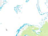
Arctic Spatial Data Infrastructure
|
|
|
- Gwen Parks
- 5 years ago
- Views:
Transcription
1 Arctic Spatial Data Infrastructure à Enabling Access to Arctic Land and Marine Data Across Borders, Across Time Simon Riopel, GeoConnections Canada Centre for Mapping and Earth Observation Draft
 Catalogues and Spatial Web Services Harvesting User Needs Assessments Video: https://www.youtube.com/watch?")
2 Outline Arctic SDI Definition Components: Governance Stakeholders requirements and technical support Data and standards Operational policies Applications (i.e. Geoportal) Catalogues and Spatial Web Services Harvesting User Needs Assessments Video: ltedwelak


3 Allows sharing geospatial data in an efficient and flexible way People adheres to Open Data Standards Technology SDI Standards Policies and its development is facilitated by the National Mapping Agencies of the eight Arctic Countries.
, Open data standards and provision of authoritative data, Helping users and data contributors Graphic Source: OGC")
4 A Cooperative Model in the Arctic The Arctic SDI is focused on: Working with organizations to make their data available, with a focus on the Arctic Council, Understanding the needs and requirements of stakeholders, Information Management best practices (lifecycle of geospatial data), Open data standards and provision of authoritative data, Helping users and data contributors Graphic Source: OGC understand how to participate.

5 Arctic SDI Strategic Plan : 6 Objectives Data Data

6 Arctic SDI Data Working Group The Data WG is a sub-group of the Technical Working Group with Terms of Reference approved Jan Areas of interest include: Focus on Arctic issues by evaluating spatial data requirements, Advise and engage in Geoportal related data activities, and Engage in outreach and communication activities. Proposed Activities 2018/19 Arctic SDI high level data flows diagram Process for thematic data separation and prioritization Arctic Council data priorities Marine Data Infrastructure: Collaborating with International Hydrographic Organization - Arctic Marine Spatial Data Infrastructure Working Group (ARMSDIWG) Academic and scientific data 6
7 Governance Arctic Council, UN-GGIM Policy Drivers Ecosystems based monitoring / Cumulative Impacts, Indigenous Reconciliation, Innovation Applications Arctic SDI GeoPortal; Arctic Council Conservation of Arctic Flora and Fauna Arctic Biodiversity Data Service Standards & Web Services Open Geospatial Consortium, International Hydrographic Organization, International Organization for Standards (ISO) Secondary Data Interpreted, thematic, aggregated data from around the world Primary Data Satellite Imagery SDI Assessments, Operations, Manuals, Requirements, Forums 7 SDI Operational Policy
8 Data Lifecycle and Standards Acquisition Earth Observation, Statistical, Vector, SensorData Management Description, Metadata and Storage Access Discovery Use Analysis, Preservation


 A geoportal for geospatial data")
9 Arctic SDI 9 The Arctic SDI provides, via a web portal, easy access to: A searchable metadata catalogue Authoritative reference data as a Web Map Service (WMS) 1:250,000 Thematic data (birds, ice cover, ship routes, land cover change, flora etc.) A geoportal for geospatial data viewing and discovery
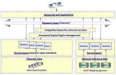
10 Arctic SDI Metadata Catalogue 10 The Metadata Catalogue for Arctic SDI is built on GeoNetwork 2.6. It provides a machine to machine Discovery Service API (OGC CSW) but also a GUI (Graphical User Interface) for administration (e.g. configuration of harvesting metadata from other metadata catalogues). The official UI for the Metadata search is the Arctic SDI Geoportal. Responsibilities The service is operated by the Swedish Mapping, Cadastral and Land Registration Authority in the Arctic SDI cloud environment hosted by the Norwegian Mapping Authority. Standards Compliance The Catalogue is compliant with the OGC CSW API version and ISO 19115/19139 metadata profiles. Access Information The metadata catalogue can be openly accessed through the Search tab -> Metadata Search tab in the Arctic SDI Geoportal. Essential interactions in a service-oriented architecture Link to Catalogue Service API (Capability file): geonetwork/srv/en/cs w?service=csw&req uest=getcapabilities
 Database Filter Arctic SDI catalogue SDI Arctic SDI member websites / websites geoportals Monitor QoS Choosing data & services relevant for the Arctic")
11 Arctic Web Services Harvesting An Evergreen Catalogue Approach Update service descriptions Tune and refine the filter (weights and thresholds) Control datasets Service identification (crawler) Database Filter Arctic SDI catalogue SDI Arctic SDI member websites / websites geoportals Monitor QoS Choosing data & services relevant for the Arctic SDI domain


12 Data Flows WCS WMTS WFS WMS-T WMS
13


14 NATIONAL DATA Customised VMAP0 Data for small scales WMTS NATIONAL DATA NATIONAL DATA Cascaded WMS National Data Larger scales WMTS Server Tile Cache - GeoWebCache - centos Apply common portrayal(sld) Rules created by project group Tile Cache National Data and Service Layer ASDI Service Integration Layer Application Layer

15 Authoritative Topographic Basemap Provided Directly from the 8 Arctic National Mapping Agencies Common Cartographic Specification A Trusted Source of Detailed Information Southern Svalbard: Arctic SDI Basemap vs. Google Maps

16 Arctic SDI Geoportal / Arctic-SDI.org 16 Functionalities Location Search Metadata Search Map Layers & Coordinate Tool Time Series (WMS-T) Embedded Maps Wizard Your Own Maps Geoportal Administration

 Land Cover Type Snow Covered Area Sea Surface")

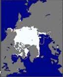
17 Technical Support Assisting CAFF with thematic data services MODIS satellite data derived products: Vegetation Indices (incl. NDVI) Land Cover Type Snow Covered Area Sea Surface Temperature (SST) Marine Chlorophyll-a Time-Series Migratory Bird Index 2012 Land Cover Type Land Surface Temperature Sea Surface Temperature 17

18 Embedded Maps 18
19 Arctic-SDI.org: Operational Policies SDI Manual for the Arctic Data Sharing Agreements Guidelines for Data Providers (under creation) Geoportal Disclaimer (Terms of Use): 19 This Arctic SDI Geoportal is intended to provide free and open access for any user. Some data available through this Geoportal may have usage restrictions. Using some features of the Geoportal may require registering and signing in as an authenticated user. The Arctic SDI incorporates data from multiple, distributed providers and each data set has a specific license. Arctic SDI's Geoportal Metadata Catalogue links to these data licenses as supplied by the respective data providers and it is the responsibility of the user to comply with these licenses, disclaimers, and/or copyright notices Open Government Licence Canada You are free to: Copy, modify, publish, translate, adapt, distribute or otherwise use the Information in any medium, mode or format for any lawful purpose.
20 SDI User Needs Assessments 20 The objective of this project is to conceptualise, document, frame and develop detailed user needs assessments (UNAs) that will gather the requirements of Canadian stakeholders and the international Arctic community in terms of: data and services (land and marine), standards technologies (e.g. applications) operational policies collaboration, and leadership & governance. Specifically, this project will consist of researching and detailing the SDI requirements of different communities: Canadian stakeholders (CGDI), International Arctic Community, and Indigenous Communities (First Nations, Inuit, Métis).
21 Data Providers, Platforms and Facilitators 21 Arctic Spatial Data Infrastructure (Arctic SDI) Geoportal Polar Thematic Exploitation Platform (Polar TEP) GEOSS Portal Observing Systems Capability Analysis and Review Tool (OSCAR) Global Change Master Directory (GCMD) Polar Data Catalogue (PDC) Exchange for Local Observations and Knowledge of the Arctic (ELOKA) Atlas of Community-Based Monitoring in a Changing Arctic
22 Data Access and Use Issues 22 Access/Use of required data is impeded by a number of data issues Missing Metadata for OGC Web Services Proprietary/custom data formats Lack of styling for Vector Data Incorporating temporal characteristics into data Vendor Specific Solutions Openness and Accessibility of Data Poor Interoperability Inefficiencies of un-aggregated data Limited resources and capacity


23 23 Arctic Spatial Data Pilot - Climate Change Scenarios Sponsored by NRCan and USGS, in collaboration with the Arctic SDI participants, this Open Geospatial Consortium Arctic Spatial Data Pilot: Defined land and sea climate change scenarios to break down information management silos with technical piloting activities: Improved access to reliable data for monitoring, management, emergency preparedness and decision making in the Arctic, Produced videos to showcase how standards and common approaches to data management are deployed. Addressed technology issues to meet the realities of Arctic frontier economies, such as in zero/low bandwidth Internet.
24 24 Arctic Spatial Data Pilot - Videos VIDEOS Case Studies by Pilot Participants
25 DATA SPECIFICATIONS - ARCTIC SDI 25 Thematic datasets: Data used in climate change modelling (e.g. ground/cloud albedo, sea-surface temperature, ice thickness, 30 year averages of snow/temperature, ice extent and thickness, glaciers, permafrost, ) Coastline and near shore data Data related for flora or fauna and/or their habitat Paleoclimatological data Black Carbon Greenhouse gases (e.g. Methane) Ozone...?
26 STANDARDS - ARCTIC SDI 26 Supported standards in Arctic SDI Geoportal WMS 1.3 WMS-T (temporal) WMTS (tile) WFS 2.0 (GML 3.2) ESRI REST services CSW (if you can create one with NSIDC Arctic metadata) ISO 19115, 19139, etc. Support for the following projections (amongst others) EPSG (polar projections) Web Mercator Standards that we are working towards and need further support include: WCS 2.0 WPS and/or DGGS to support analytical and modelling exercises or, alternatively, existing models that can be instantiated with distributed data via WPS/DGGS standards (service chaining) SOS for near real time monitoring (e.g. currents, physical chemistry, pollutants, temperature, etc.) Marine standards (e.g. OGC Marine DWG, IHO) APIs that respect standardization efforts SLD and improving cartography Reference: SDI Manual for the Arctic with its Glossary of Terms.


27 Improved access to geospatial data can help us better to predict, understand and react to changes in the Arctic. Responding to the impact of climate change and human activities in the Arctic requires accessible and reliable data to facilitate monitoring, management, emergency preparedness and decision making. Important datasets are produced and distributed by many stakeholders public and private sector and most of it can be geographically referenced.


28 Arctic-SDI.org 28
Enabling Access to Arctic Location Based Information
 Enabling Access to Arctic Location Based Information Kevin Gallagher Arctic SDI Board Chair, United States Geological Survey Alaska Surveying and Mapping Conference, GeoJam 15 February 2017 What is Arctic
Enabling Access to Arctic Location Based Information
 Enabling Access to Arctic Location Based Information Jani Kylmäaho Arctic SDI Geoportal WG Lead National Land Survey of Finland INSPIRE Conference 29 September 2016 http://wallpaper.imcphoto.net/animals/polar
Enabling Access to Arctic Location Based Information - the Arctic SDI
 Enabling Access to Arctic Location Based Information - the Arctic SDI Jani Kylmäaho Head of Arctic SDI Geoportal WG National Land Survey of Finland SAO Chair, WG Chairs and Executive Secretaries meeting
Arctic Spatial Data Infrastructure Enabling Access to Arctic Location-Based Information
 Arctic Spatial Data Infrastructure Enabling Access to Arctic Location-Based Information Arctic SDI Side Event Co-Chairs: Arvo Kokkonen Arctic SDI Board Chair & Director General, National Land Survey of
Arctic Spatial Data Infrastructure (Arctic SDI)
") Arctic Spatial Data Infrastructure (Arctic SDI) Arvo KOKKONEN, Jani KYLMÄAHO and Heli URSIN, Finland Key words: SDI, Arctic, Geoportal SUMMARY Understanding and responding to the impacts of climate change
Arctic Spatial Data Infrastructure (Arctic SDI) Arvo KOKKONEN, Jani KYLMÄAHO and Heli URSIN, Finland Key words: SDI, Arctic, Geoportal SUMMARY Understanding and responding to the impacts of climate change
Ministry of ICT of I.R.IRAN
 The ECO 8/6 mill km 2 10 Slamic countries ~330 mill people Oil, Gas, Industries,Tourism 2 Issue transformation in last decade Problem solving needs more integrated approach More interaction &complexity
8 th Arctic Regional Hydrographic Commission Meeting September 2018, Longyearbyen, Svalbard Norway
 8 th Arctic Regional Hydrographic Commission Meeting 11-13 September 2018, Longyearbyen, Svalbard Norway Status Report of the Arctic Regional Marine Spatial Data Infrastructures Working Group (ARMSDIWG)
The Polar Data Landscape
 The Polar Data Landscape Polar Data Activities, Models and Issues from Local to Global Peter L. Pulsifer, NSIDC, GCRC Carleton University Cameron Wilson, Natural Resources Canada (NRCan) Martha Paiz, Natural
Spatially Enabled Society
 International Seminar on Land Administration Trends and Issues in Asia and the Pacific Region Spatially Enabled Society Abbas Rajabifard Vice Chair PCGIAP-WG3 Vice-President (President Elect), GSDI Association
ArcGIS for INSPIRE. Marten Hogeweg
 ArcGIS for INSPIRE Marten Hogeweg Please Take Our Survey on the App Download the Esri Events app and find your event Select the session you attended Scroll down to find the feedback section Complete answers
INSPIREd solutions for Air Quality problems Alexander Kotsev
 INSPIREd solutions for Air Quality problems Alexander Kotsev www.jrc.ec.europa.eu Serving society Stimulating innovation Supporting legislation The European data puzzle The European data puzzle 24 official
Marine Spatial Planning, a Norwegian user case NSHC33
 Marine Spatial Planning, a Norwegian user case NSHC33 Marine Spatial Management Tool Support the marine spatial planning process with updated and reliable geospatial information Marine management is important
Geospatial Policy Development and Institutional Arrangements *
 HIGH LEVEL FORUM ON GLOBAL GEOSPATIAL MANAGEMENT INFORMATION WORKING PAPER No. 13 First Forum Seoul, Republic of Korea, 24-26 October 2011 Geospatial Policy Development and Institutional Arrangements *
From the Venice Lagoon Atlas towards a collaborative federated system
 From the Venice Lagoon Atlas towards a collaborative federated system City of Venice Alessandro Mulazzani CORILA Consortium for Coordination of Research Activities Concerning the Venice Lagoon System ISMAR-CNR
Using OGC standards to improve the common
 Using OGC standards to improve the common operational picture Abstract A "Common Operational Picture", or a, is a single identical display of relevant operational information shared by many users. The
Observation (EO) & Geomatics in Canada
 & Geomatics in Canada") Innovating to Increase the Impact of Earth Observation (EO) & Geomatics in Canada Natural Resources Canada February 25, 2014 Prashant Shukle, Director General Canada Centre for Mapping and Earth Observation
Innovating to Increase the Impact of Earth Observation (EO) & Geomatics in Canada Natural Resources Canada February 25, 2014 Prashant Shukle, Director General Canada Centre for Mapping and Earth Observation
European Location Framework data in the ArcGIS platform
 European Location Framework data in the ArcGIS platform Presentation to: Author: Date: INSPIRE Conference 2016 Clemens Portele 26 September 2016 Why ELF? Global (e.g. UN GGIM) Regional Europe (INSPIRE
Global Geospatial Information Management Country Report Finland. Submitted by Director General Jarmo Ratia, National Land Survey
 Global Geospatial Information Management Country Report Finland Submitted by Director General Jarmo Ratia, National Land Survey Global Geospatial Information Management Country Report Finland Background
GIS Building Communities beyond National Borders (Building Successful Spatial Data Infrastructures) Nick Land, ESRI Europe
 Nick Land, ESRI Europe") GIS Building Communities beyond National Borders (Building Successful Spatial Data Infrastructures) Nick Land, ESRI Europe UK worst flooding in the last 60 years 350,000 households without drinking water
GIS Building Communities beyond National Borders (Building Successful Spatial Data Infrastructures) Nick Land, ESRI Europe UK worst flooding in the last 60 years 350,000 households without drinking water
2007 / 2008 GeoNOVA Secretariat Annual Report
 2007 / 2008 GeoNOVA Secretariat Annual Report Prepared for: Assistant Deputy Minister and Deputy Minister of Service Nova Scotia and Municipal Relations BACKGROUND This report reflects GeoNOVA s ongoing
REGION AND STATES INTERCONNEXIONS : CRIGE PACA, SWISSTOPO AND FRENCH PORTALS. Dr. C. Giger (swisstopo) S. Maffren (CRIGE PACA) D.
 S. Maffren (CRIGE PACA) D.") REGION AND STATES INTERCONNEXIONS : CRIGE PACA, SWISSTOPO AND FRENCH PORTALS Dr. C. Giger (swisstopo) S. Maffren (CRIGE PACA) D. Richard (IGN) Components to connect PACA portal French Geoportal Local datasets
REGION AND STATES INTERCONNEXIONS : CRIGE PACA, SWISSTOPO AND FRENCH PORTALS Dr. C. Giger (swisstopo) S. Maffren (CRIGE PACA) D. Richard (IGN) Components to connect PACA portal French Geoportal Local datasets
The state-of-the-art of the Finnish SDI. Arctic SDI WG Meeting
 The state-of-the-art of the Finnish SDI Arctic SDI WG Meeting Moscow 8.9.2011 Esa Tiainen Development Centre 1 NATIONAL LAND SURVEY DOWN TO EARTH Contents Legal framework Coordination structure Network
US National Spatial Data Infrastructure A Spatial Framework for Governance and Policy Development to Enable a Location-Based Digital Ecosystem
 GeoPlatform Workshop 7 Dec 2016, Department of the Interior Washington, D.C. US National Spatial Infrastructure A Spatial Framework for Governance and Policy Development to Enable a Location-Based Digital
Standards in Action: The Canadian Geospatial Data Infrastructure (CGDI)
") Standards in Action: The Canadian Geospatial Data Infrastructure (CGDI) Craig Stewart ISO/TC211 Standards in Action Workshop, September 14, 2005 Presentation Outline Overview of SDIs Overview of Canada
Standards in Action: The Canadian Geospatial Data Infrastructure (CGDI) Craig Stewart ISO/TC211 Standards in Action Workshop, September 14, 2005 Presentation Outline Overview of SDIs Overview of Canada
Overview of Geospatial Open Source Software which is Robust, Feature Rich and Standards Compliant
 Overview of Geospatial Open Source Software which is Robust, Feature Rich and Standards Compliant Cameron SHORTER, Australia Key words: Open Source Geospatial Foundation, OSGeo, Open Standards, Open Geospatial
2018/1 The integration of statistical and geospatial information. The Regional Committee of UN-GGIM: Americas:
 The following are the conclusions and recommendations of the Regional Committee of the United Nations on Global Geospatial Information Management for the Americas, during its Fifth Session, Thursday 8
ArcGIS for INSPIRE. Marten Hogeweg Satish Sankaran
 ArcGIS for INSPIRE Marten Hogeweg Satish Sankaran Outline What is ArcGIS ArcGIS for INSPIRE Web GIS Case Studies Roadmap Q&A What is INSPIRE? INSPIRE is the legal framework for a European Spatial Data
Data Aggregation with InfraWorks and ArcGIS for Visualization, Analysis, and Planning
 Data Aggregation with InfraWorks and ArcGIS for Visualization, Analysis, and Planning Stephen Brockwell President, Brockwell IT Consulting, Inc. Join the conversation #AU2017 KEYWORD Class Summary Silos
Technical Framework Methodology as a core of building up the NSDI NSDI Implementation Specifics in Serbia
 Technical Framework Methodology as a core of building up the NSDI NSDI Implementation Specifics in Serbia Luka Jovičić SDI Consultant@ Gramont Ltd. Aleksandar Dedić RGA NSDI department Dragica Pajić RGA
Implementing INSPIRE in Sweden
 Implementing INSPIRE in Sweden Christina Wasström NSDI-unit, Lantmäteriet Christina.wasstrom@lm.se Standards Cooperation Metadata Competence Infrastructure for Geodata Legal Framework Portal Services Geodata
Health DWG ad-hoc. May 31 st, 2013 OGC-TC
 Health DWG ad-hoc May 31 st, 2013 OGC-TC AGENDA 1. Welcome / Roundtable Introductions 2. Background of OGC and proposal of Health DWG 3. Toward an OGC Health DWG 4. Draft Health DWG Charter 5. Potential
THE WASHINGTON COASTAL ATLAS
 THE ICAN COASTAL ATLAS MEDIATOR PROTOTYPE AND CONNECTING THE WASHINGTON COASTAL ATLAS Liz O Dea 1, Yassine Lassoued 2, Tanya Haddad 3, Declan Dunne 2 1 GIS Services Unit, WA State Dept. of Ecology 2 Coastal
Marine Spatial Management Tool
 Marine Spatial Management Tool Marine Spatial Management Tool Support the marine spatial planning process with updated and reliable geospatial information Marine management is important to Norway with
EXPECTATIONS OF TURKISH ENVIRONMENTAL SECTOR FROM INSPIRE
 EXPECTATIONS OF TURKISH ENVIRONMENTAL SECTOR FROM INSPIRE June, 2010 Ahmet ÇİVİ Tuncay DEMİR INSPIRE in the Eyes of MoEF Handling of Geodata by MoEF Benefits Expected TEIEN First Steps for INSPIRE Final
Spatial data interoperability and INSPIRE compliance the platform approach BAGIS
 Spatial data interoperability and INSPIRE compliance the platform approach BAGIS BAGIS Voluntary, independent, public, non-profit organization; Organization with main mission to promote the growth of the
CHAPTER 22 GEOGRAPHIC INFORMATION SYSTEMS
 CHAPTER 22 GEOGRAPHIC INFORMATION SYSTEMS PURPOSE: This chapter establishes the administration and use of to improve the quality and accessibility of Department s spatial information and support graphical
a national geological survey perspective François ROBIDA BRGM (French Geological Survey)
") a national geological survey perspective François ROBIDA BRGM (French Geological Survey) Pre-Conference Seminar on Socio-Economic Value of Geospatial for National and Regional Development 21 August 2017,
a national geological survey perspective François ROBIDA BRGM (French Geological Survey) Pre-Conference Seminar on Socio-Economic Value of Geospatial for National and Regional Development 21 August 2017,
EuroSDR (European Spatial Data Research)
") EuroSDR (European Spatial Data Research) ROLLING RESEARCH PLAN 2015-2018 EuroSDR Secretariat Public Governance Institute KU Leuven Parkstraat 45 bus 3609 3000 Leuven Belgium Tel.: +32 16 32 31 80 Fax:
EuroSDR (European Spatial Data Research) ROLLING RESEARCH PLAN 2015-2018 EuroSDR Secretariat Public Governance Institute KU Leuven Parkstraat 45 bus 3609 3000 Leuven Belgium Tel.: +32 16 32 31 80 Fax:
Introduction. Elevation Data Strategy. Status and Next Steps
 1 2 Introduction Elevation Data Strategy Status and Next Steps 3 Canada is the 2nd largest country in the world - 9.9 million sq km Surrounded by 3 oceans with 202 000 km of coastline Population over 35
Realizing benefits of Spatial Data Infrastructure A user s perspective from Environment Agency - Abu Dhabi
 Realizing benefits of Spatial Data Infrastructure A user s perspective from Environment Agency - Abu Dhabi Anil Kumar Director, Environment Information Management 26 April 2012 Geospatial World Forum,
INSPIRE Basics. Vlado Cetl European Commission Joint Research Centre. https://ec.europa.eu/jrc/
 INSPIRE Basics Vlado Cetl European Commission Joint Research Centre https://ec.europa.eu/jrc/ Serving society Stimulating innovation Supporting legislation Outline SDI? Why European SDI? INSPIRE Policy
Economic and Social Council
 United Nations Economic and Social Council Distr.: General 18 July 2016 Original: English Committee of Experts on Global Geospatial Information Management Sixth session New York, 3-5 August 2016 Item 2
Standards in support of UN-GGIM and sustainable development
 2 nd High 2Level nd High Forum Level on GGIM, Forum QNCC, on GGIM Doha, Qatar, 6 February 2013 QNCC, Doha, Qatar, 6 February 2013 Standards in support of UN-GGIM and sustainable development Olaf Østensen
> TOOLKIT VERSION 2.0
 MODULE 5 > TOOLKIT V 2.0 5 LOCAL GOVERNMENT SPATIAL > TOOLKIT VERSION 2.0 Building capacity for integrated spatial information management solutions JULY 2007 MODULE 5 Finding and getting hold of spatial
Discovery and Access of Geospatial Resources using the Geoportal Extension. Marten Hogeweg Geoportal Extension Product Manager
 Discovery and Access of Geospatial Resources using the Geoportal Extension Marten Hogeweg Geoportal Extension Product Manager DISCOVERY AND ACCESS USING THE GEOPORTAL EXTENSION Geospatial Data Is Very
SPATIAL DATA INFRASTRUCTURE (SDI) MANUAL FOR THE ARCTIC
 MANUAL FOR THE ARCTIC") S732001kev S732001kev S732001kev SPATIAL DATA INFRASTRUCTURE (SDI) MANUAL FOR THE ARCTIC A collective work by the national mapping agencies of the eight Arctic countries: Canada, Finland, Iceland, Norway,
S732001kev S732001kev S732001kev SPATIAL DATA INFRASTRUCTURE (SDI) MANUAL FOR THE ARCTIC A collective work by the national mapping agencies of the eight Arctic countries: Canada, Finland, Iceland, Norway,
SITMUN: Cooperating to Build Local SDIs in the Barcelona Region
 SITMUN: Cooperating to Build Local SDIs in the Barcelona Region Diputació de Barcelona Territory and Sustainability Area Territorial Information Systems Department INSPIRE CONFERENCE Barcelona, September
UN-GGIM Arab States Meeting Welcome Address. Denise McKenzie Open Geospatial Consortium 21 February 2017 Doha, Qatar
 UN-GGIM Arab States Meeting Welcome Address Denise McKenzie Open Geospatial Consortium 21 February 2017 Doha, Qatar The Open Geospatial Consortium Not-for-profit, international voluntary consensus standards
SWEDISH SDI DEVELOPMENT & IMPLEMENTATION OF INSPIRE
 SWEDISH SDI DEVELOPMENT & IMPLEMENTATION OF INSPIRE Christina Wasström, Lantmäteriet, 801 82 Gävle, Sweden, christina.wasstrom@lm.se ABSTRACT The Swedish Government and Parliament has given Lantmäteriet
Land Board, NW Services and SDI Tambet Tiits, FRICS
 Land Board, NW Services and SDI Tambet Tiits, FRICS 07.09.2016 200th anniversary of the Struve Geodetic Arc Friedrich Georg Wilhelm Struve and Carl Friedrich Tenner Struve Geodetic Arc The Struve Geodetic
Spatial Data Infrastructure Concepts and Components. Douglas Nebert U.S. Federal Geographic Data Committee Secretariat
 Spatial Data Infrastructure Concepts and Components Douglas Nebert U.S. Federal Geographic Data Committee Secretariat August 2009 What is a Spatial Data Infrastructure (SDI)? The SDI provides a basis for
Norwegian spatial data infrastructure supporting disaster risk management Norwegian Mapping Authority
 Norwegian spatial data infrastructure supporting disaster risk management Norwegian Mapping Authority Arvid Lillethun, Norwegian Mapping Authority Land and Poverty 2018 Conference, World Bank 19.-23. March
Proposal for a DIRECTIVE OF THE EUROPEAN PARLIAMENT AND OF THE COUNCIL. establishing an infrastructure for spatial information in the Community
 Proposal for a DIRECTIVE OF THE EUROPEAN PARLIAMENT AND OF THE COUNCIL establishing an infrastructure for spatial information in the Community INSPIRE http://inspire.jrc.it/ Alessandro Annoni 1 EU Commission
Major Opportunities in Spatial Data Infrastructure Communities
 Major Opportunities in Spatial Data Infrastructure Communities Bas Kok President GSDI June 17 th 2008 FIG Working Week: Integrating Generations 14-19 June 2008 Stockholm, Sweden http://www.gsdi.org 1 GSDI
The PREVIEW Global Risk Data Platform: a geoportal to serve and share global data on risk to natural hazards
 The PREVIEW Global Risk Data Platform: a geoportal to serve and share global data on risk to natural hazards Gregory Giuliani (UNEP/GRID-Geneva & University of Geneva/enviroSPACE ) http://www.grid.unep.ch
Horizontal Interoperability among National Geoportals of ES, FR, PT & AD
 Horizontal Interoperability among National Geoportals of ES, FR, PT & AD A. F. Rodríguez S. Mas, D. Richard, J. M. Nataf, D. Furtado, R. P. Julião, S. Pijuan, S. Alba 1 Next 15 minutes Intoduction 4 National
CLICK HERE TO KNOW MORE
 CLICK HERE TO KNOW MORE GeoSpace for Singapore s Whole-of-Government Data Sharing Asia GeoSpatial Forum 17 19 Oct 2011 Lee Kim Haw Singapore Land Authority Introducing Singapore Land Authority Limited
Paper UC1351. Conference: User Conference Date: 08/10/2006 Time: 8:30am-9:45am Room: Room 23-B (SDCC)
") Conference: User Conference Date: 08/10/2006 Time: 8:30am-9:45am Room: Room 23-B (SDCC) Title of Paper: Increasing the Use of GIS in the Federal Government Author Name: Miss Abstract This presentation
Conference: User Conference Date: 08/10/2006 Time: 8:30am-9:45am Room: Room 23-B (SDCC) Title of Paper: Increasing the Use of GIS in the Federal Government Author Name: Miss Abstract This presentation
IRDAT Fvg, evolving a regional Spatial Data Infrastructure according to INSPIRE
 IRDAT Fvg, evolving a regional Spatial Data Infrastructure according to INSPIRE Tutti i diritti riservati. Proprietà INSIEL SpA. A. Benvenuti, A. Chiarandini Insiel (Italy) M. Lunardis - Friuli Venezia
National Spatial Data Infrastructures (NSDIs): North American Experience
: North American Experience") National Spatial Data Infrastructures (NSDIs): North American Experience Henry Tom International Symposium on NSDI (National Spatial Data Infrastructure) Center for Spatial Information Science University
National Spatial Data Infrastructures (NSDIs): North American Experience Henry Tom International Symposium on NSDI (National Spatial Data Infrastructure) Center for Spatial Information Science University
A Spatial Data Infrastructure for Landslides and Floods in Italy
 V Convegno Nazionale del Gruppo GIT Grottaminarda 14 16 giugno 2010 A Spatial Data Infrastructure for Landslides and Floods in Italy Ivan Marchesini, Vinicio Balducci, Gabriele Tonelli, Mauro Rossi, Fausto
INSPIRing Geospatial Framework For Local Administrations
 This project is financed by the European Union and the Republic of Turkey Presented at the FIG Congress 2018, May 6-11, 2018 in Istanbul, Turkey National Programme for Turkey 2010 Instrument for Pre-Accession
SDI DEVELOPMENT UPDATES OF INDONESIA
 SDI DEVELOPMENT UPDATES OF INDONESIA DR. ANTONIUS B. WIJANARTO Center For Management And Dissemination Of Geospatial Information GEOSPATIAL INFORMATION AUTHORITY GOVERNMENT OF THE REPUBLIC OF INDONESIA
INDONESIA S S UPDATE: GEOSPATIAL INFORMATION FOR SUSTAINABLE DEVELOPMENT RELATED TO INA SDI Dr. Asep Karsidi, M.Sc
 INDONESIA S S UPDATE: GEOSPATIAL INFORMATION FOR SUSTAINABLE DEVELOPMENT RELATED TO INA SDI Dr. Asep Karsidi, M.Sc GEOSPATIAL INFORMATION AGENCY 08 August, 2012 OUTLINE 1. Transformation Bakosurtanal into
Hosted by Esri Official Distributor
 Hosted by Esri Official Distributor Esri European User Conference October 15-17, 2012 Oslo, Norway Hosted by Esri Official Distributor Interoperability and Standards Support in ArcGIS 10.1 Roberto Lucchi
Technical Specifications. Form of the standard
 Used by popular acceptance Voluntary Implementation Mandatory Legally enforced Technical Specifications Conventions Guidelines Form of the standard Restrictive Information System Structures Contents Values
ESTABLISHMENT OF KARNATAKA GEOPORTAL AND ITS ROLE IN PLANNING
 ESTABLISHMENT OF KARNATAKA GEOPORTAL AND ITS ROLE IN PLANNING By H. Hemanth Kumar Karnataka State Council for Science & Technology (KSCST), Indian Institute of Science, Bangalore, India Abstract Natural
Country Report on SDI Activities in Singapore *
 UNITED NATIONS E/CONF.100/CRP.9 ECONOMIC AND SOCIAL COUNCIL Eighteenth United Nations Regional Cartographic Conference for Asia and the Pacific Bangkok, 26-29 October 2009 Item 7(a) of the provisional
SDI Development in Georgia. Mari Khardziani Head of International Relations Unit National Agency of Public Registry
 SDI Development in Georgia Mari Khardziani Head of International Relations Unit National Agency of Public Registry Kehl, Germany September 5, 2017 2 National Agency of Public Registry Legal Entity of Public
Implementation of INSPIRE Principles: Sardinia Region SDI State of the Art and Further Developments
 REGION OF SARDINIA (ITALY) LOCAL AUTHORITY FOR MUNICIPALITIES, FINANCES AND URBAN PLANNING DEPT. FOR THE REGIONAL SPATIAL DATA INFRASTRUCTURE Implementation of INSPIRE Principles: Sardinia Region SDI State
INFORMATION PAPER TO THE SAO MEETING APRIL 2008.
 Arctic Council Open Access Repository Arctic Council http://www.arctic-council.org/ 1.6 Norway Chairmanship I (Oct 2006 - Apr 2009) 3. SAO Meeting, 23-24 April 2008, Svolvær, Norway INFORMATION PAPER TO
Arctic Spatial Data Infrastructure (SDI) - Pan-Arctic Cooperation among Ten Mapping Agencies (Skedsmo, Palmer, Taylor, Gudmundsson)
 - Pan-Arctic Cooperation among Ten Mapping Agencies (Skedsmo, Palmer, Taylor, Gudmundsson)") Arctic Arctic Spatial Data Infrastructure () - Pan-Arctic Cooperation among Ten Mapping Agencies (Skedsmo, Palmer, Taylor, Gudmundsson) G 13 2012, Quebec, Canada May 14, 2012 www. arctic-sdi.org Owe Bengt
Arctic Arctic Spatial Data Infrastructure () - Pan-Arctic Cooperation among Ten Mapping Agencies (Skedsmo, Palmer, Taylor, Gudmundsson) G 13 2012, Quebec, Canada May 14, 2012 www. arctic-sdi.org Owe Bengt
Adding value to Copernicus services with member states reference data
 www.eurogeographics.org Adding value to Copernicus services with member states reference data Neil Sutherland neil.sutherland@os.uk GIS in the EU 10 November 2016 Copyright 2016 EuroGeographics 61 member
What s the problem? A Modern Odyssey in Search of Relevance. The search for relevance. Some current drivers for new services. Some Major Applications
 A Modern Odyssey in Search of Relevance FIG Working Week, Athens, 24 May 2004 Paul Kelly ANZLIC Executive Director The search for relevance 1. New expectations for spatial services 2. Are we ready to meet
SDI and Beyond The Importance of Standards and Interoperability For Good Governance; Selected Examples
 SDI and Beyond The Importance of Standards and Interoperability For Good Governance; Selected Examples Trevor Taylor, Director, Member Services, Asia and the Americas Sao Paulo May 7 th, 2014 Why is Geospatial
Disaster Management in Mongolia
 The Third UN-GGIM-AP Plenary Meeting Disaster Management in Mongolia ~Coordination among NGIA & Other Related Organizations and Recommendations~ Bali Indonesia 10 November 2014 Khurelshagai Ayurzana, Director
Swedish Spatial Data Infrastructure and the National Geodata Strategy
 Submitted to the United Nations Committee of Experts on Global Geospatial Information Management Seventh Session New York, August 2018 Registration number 519-2018/4327 Country Report, Sweden Swedish Spatial
Status of implementation of the INSPIRE Directive 2016 Country Fiches. COUNTRY FICHE Malta
 Status of implementation of the INSPIRE Directive 2016 Country Fiches COUNTRY FICHE Malta Introduction... 1 1. State of Play... 2 1.1 Coordination... 2 1.2 Functioning and coordination of the infrastructure...
Aboriginal communities strengthen governance with location-based tools in the 21st century
 Aboriginal communities strengthen governance with location-based tools in the 21st century Today, Aboriginal communities are taking advantage of the geomatics technologies that underpin popular online
Challenges and Issues for Regional Geoportal on Disaster Data Sharing - from Perspective of China
 The 3 rd UN-GGIM-AP Plenary Meeting Challenges and Issues for Regional Geoportal on Disaster Data Sharing - from Perspective of China ZHOU Xu, Vice Chair of WG2 National Geomatics Center of China Outline
Economic and Social Council
 United Nations Economic and Social Council Distr.: General 2 July 2012 E/C.20/2012/10/Add.1 Original: English Committee of Experts on Global Geospatial Information Management Second session New York, 13-15
GIS at UCAR. The evolution of NCAR s GIS Initiative. Olga Wilhelmi ESIG-NCAR Unidata Workshop 24 June, 2003
 GIS at UCAR The evolution of NCAR s GIS Initiative Olga Wilhelmi ESIG-NCAR Unidata Workshop 24 June, 2003 Why GIS? z z z z More questions about various climatological, meteorological, hydrological and
ISO Series Standards in a Model Driven Architecture for Landmanagement. Jürgen Ebbinghaus, AED-SICAD
 ISO 19100 Series Standards in a Model Driven Architecture for Landmanagement Jürgen Ebbinghaus, AED-SICAD 29.10.2003 The Company 100% SIEMENS PTD SIEMENS Business Services Shareholder & Strategic Business
Open Data meets Big Data
 Open Data meets Big Data Max Craglia, Sven Schade, Anders Friis European Commission Joint Research Centre www.jrc.ec.europa.eu Serving society Stimulating innovation Supporting legislation JRC is Technical
Solving the European Data Puzzle Simplifying INSPIRE Challenges and Usage. con terra GmbH Dipl.-Ing. Mark Döring
 Solving the European Data Puzzle Simplifying INSPIRE Challenges and Usage con terra GmbH Dipl.-Ing. Mark Döring INSPIRE Reference Projects GeoBAK 2.0 Project // INSPIRE Data & Services The Project Evolution
ArcGIS Enterprise: What s New. Philip Heede Shannon Kalisky Melanie Summers Sam Williamson
 ArcGIS Enterprise: What s New Philip Heede Shannon Kalisky Melanie Summers Sam Williamson ArcGIS Enterprise is the new name for ArcGIS for Server What is ArcGIS Enterprise ArcGIS Enterprise is powerful
The Swedish National Geodata Strategy and the Geodata Project
 The Swedish National Geodata Strategy and the Geodata Project Ewa Rannestig, Head of NSDI Co-ordination Unit, Lantmäteriet, ewa.rannstig@lm.se Ulf Sandgren, Project Manager Geodata Project, Lantmäteriet,
Demonstration of a local SDI solution with several stakeholders in pilot areas in line with EU best practices
 EU Twinning project for the Agency of Land Relations and Cadaster (ALRC)- Organization, Streamlining and Computerization Process in Mapping in the Republic of Moldova. Demonstration of a local SDI solution
INSPIRE and Land Use Planning System in Portugal
 INSPIRE and Land Use Planning System in Portugal Rui Amaro Alves Director General Directorate General for Territorial Development ruialves@dgterritorio.pt Carlos Simões Senior Technician Directorate General
ARCTIC SPATIAL DATA INFRASTRUCTURE
 CAFF Strategy Series No. 1 January 2011 ARCTIC SPATIAL DATA INFRASTRUCTURE CONCEPT PAPER ARCTIC COUNCIL Acknowledgements The Conservation of Arctic Flora and Fauna (CAFF) is a Working Group of the Arctic
Portals: Standards in Action
 Portals: Standards in Action David Danko ISO TC 211 Metadata Project Leader GIS Standards Consultant-ESRI. Metadata Portals Portal gateway, place of entry Producers Advertise, expose products Share information
SDI-Challenges European perspective
 THE HIGH LEVEL FORUM ON GLOBAL GEOSPATIAL INFORMATION MANAGEMENT Seoul, Republic of Korea, 24-26 October 2011 Session 1: Challenges in geospatial policy formation and institutional arrangements SDI-Challenges
GeoSpace for Singapore s Whole-of-Government Data Sharing
 GeoSpace for Singapore s Whole-of-Government Data Sharing Ng Siau Yong, Lim Ming Khai, Lo Jing Lu & Anupam Mukherjee ABSTRACT Sharing of land information among government agencies is not new to Singapore.
Infrastructure for Spatial Information in Europe (INSPIRE) Steve Peedell
 Steve Peedell") Infrastructure for Spatial Information in Europe (INSPIRE) Steve Peedell European Commission DG Joint Research Centre Institute for Environment and Sustainability ESDI Action Overview JRC, European Commission
Infrastructure for Spatial Information in Europe (INSPIRE) Steve Peedell European Commission DG Joint Research Centre Institute for Environment and Sustainability ESDI Action Overview JRC, European Commission
Topographic Strategy National Topographic Office March 2015
 www.linz.govt.nz Topographic Strategy National Topographic Office March 2015 >> Foreword Topographic information is vital to understanding our country and its assets, and for supporting economic development.
Open Geospatial Consortium activities in the Maritime domain
 Open Geospatial Consortium activities in the Maritime domain Scott Simmons Executive Director, Standards Program General Maritime efforts participants Alliance partners IHO ISO / TC 211 Members Danish
The Process of Spatial Data Harmonization in Italy. Geom. Paola Ronzino
 The Process of Spatial Data Harmonization in Italy Geom. Paola Ronzino ISSUES Geospatial Information in Europe: lack of data harmonization the lack of data duplication of data CHALLENGES Challenge of INSPIRE:
The EOC Geoservice: Standardized Access to Earth Observation Data Sets and Value Added Products
 The EOC Geoservice: Standardized Access to Earth Observation Data Sets and Value Added Products Klaus Dengler, Torsten Heinen, Albert Huber, Katrin Molch, Eberhard Mikusch DLR German Remote Sensing Data
FAO GAEZ Data Portal
 FAO GAEZ Data Portal www.fao.org/nr/gaez Renato Cumani Environment Officer Land and Water Division Natural Resources Management and Environment Department Food and Agriculture Organization of the UN October
INSPIRE - A Legal framework for environmental and land administration data in Europe
 INSPIRE - A Legal framework for environmental and land administration data in Europe Dr. Markus Seifert Bavarian Administration for Surveying and Cadastre Head of the SDI Office Bavaria Delegate of Germany