Transportation Statistical Data Development Report OKALOOSA-WALTON OUTLOOK 2035 LONG RANGE TRANSPORTATION PLAN
|
|
|
- Randall Elliott
- 5 years ago
- Views:
Transcription
1 Transportation Statistical Data Development Report OKALOOSA-WALTON OUTLOOK 2035 LONG RANGE TRANSPORTATION PLAN Prepared for the Okaloosa-Walton Transportation Planning Organization and The Florida Department of Transportation, District Three Prepared by the West Florida Regional Planning Council Staff to the Okaloosa-Walton Transportation Planning Organization February 2011 This report was financed in part by the U.S. Department of Transportation, Federal Highway Administration, the Florida Department of Transportation, and local participating governments, in partial fulfillment of UPWP Work Task
2 Okaloosa-Walton Transportation Planning Organization Transportation Statistical Data Development and Review Report Prepared by the: West Florida Regional Planning Council Staff to the Okaloosa-Walton Transportation Planning Organization Contact information for the Okaloosa-Walton Transportation Planning Organization is as follows: Post Office Box or 4081 E. Olive Road, Suite A Pensacola, Florida Pensacola, Florida Telephone: Facsimile: (800) (850) (850) Prepared by: Christy R. Johnson AICP, Transportation Planner III christy.johnson@wfrpc.org Okaloosa-Walton Data Report 2035 Plan Update
3 Table of Contents Chapter Page Number INTRODUCTION... 1 TRAFFIC ANALYSIS ZONE STRUCTURE... 5 TAZ Development Procedure... 5 TRAFFIC ANALYSIS ZONE (TAZ) DATA DEVELOPMENT... 7 Base Year Data Development... 9 Dwelling Units... 9 Population... 9 Employment... 9 Hotel/Motel Units School Enrollment Base Year Data Review Land Use Scenarios Trend Analysis 12 Compact Development (Infill Development) Forecast Years Data Development Housing Data Employment Data Population Data School Enrollment TRAFFIC ANALYSIS ZONE (TAZ) STATISTICAL DATA Okaloosa-Walton Data Report 2035 Plan Update ii
4 List of Figures and Tables Figures/Tables Page Number FIGURE 1 LONG RANGE TRANSPORTATION PLAN STATEWIDE LOCATION MAP... 3 FIGURE 2 LONG RANGE TRANSPORTATION PLAN AREA STUDY BOUNDARY... 4 TABLE 1 - FORECAST YEAR DWELLING UNIT PROJECTIONS BY UNIT TYPE BY LONG TRANSPORTATION PLAN STUDY AREA TABLE 2 - FORECAST YEAR EMPLOYMENT PROJECTIONS BY EMPLOYMENT TYPE BY LONG TRANSPORTATION PLAN STUDY AREA TABLE 3 - FORECAST YEAR POPULATION PROJECTIONS BY LONG RANGE TRANSPORTATION PLAN STUDY AREA TABLE 4 - FORECAST YEAR HOTEL/MOTEL PROJECTIONS BY LONG RANGE TRANSPORTATION PLAN STUDY AREA TABLE 5 - FORECAST SCHOOL ENROLLMENT PROJECTIONS BY LONG RANGE TRANSPORTATION PLAN STUDY AREA Okaloosa-Walton Data Report 2035 Plan Update iii
5 List of Appendices Appendix A. Appendix B. Appendix C. Appendix D. Appendix E. Appendix F. Appendix G Base Year Data by Traffic Analysis Zone (TAZ) 2015 Data by Traffic Analysis Zone (TAZ) 2020 Data by Traffic Analysis Zone (TAZ) 2025 Data by Traffic Analysis Zone (TAZ) 2030 Data by Traffic Analysis Zone (TAZ) 2035 Data by Traffic Analysis Zone (TAZ) Traffic Analysis Zone (TAZ) Map Okaloosa-Walton Data Report 2035 Plan Update iv
6 INTRODUCTION The purpose of the Transportation Statistical Data Development Report is to provide a summary of the data compilation effort and to provide a review of the socioeconomic composition of Okaloosa and Walton Counties, in preparation for the Okaloosa-Walton Transportation Outlook 2035 Long Range Transportation Plan. Future performance of the regional transportation network is affected by the growth of population, households, employment, hotel-motel units and school enrollment. Land use and transportation are inextricably linked. Because of this direct relationship, it is important to assess the socioeconomic data projections in order to develop a clear understanding of the evolving travel patterns. Population and employment growth underscores the need for a wide array of transportation options. Therefore, a thorough understanding of the socioeconomic growth helps us determine how and where transportation investments should be leveraged over the next 20 years. Most of the information in this report is used as data input to the travel demand modeling process to forecast the transportation needs for the Okaloosa-Walton Transportation Planning Organization (TPO) through the year The socioeconomic data will be inputs to the Northwest Florida Regional Planning Model. The socioeconomic data set for the base year (2006) was prepared by the West Florida Regional Planning Council. All base year data for the Okaloosa-Walton 2035 Long Range Transportation Plan is based on conditions on the ground as of Forecast data for the years 2015, 2020, 2025, 2030 and 2035 are developed at the Traffic Analysis Zone (TAZ) level. A TAZ is a special area delineated by transportation planners for tabulating traffic-related data, especially journey-to-work and place-of-work statistics. The Northwest Florida Regional Planning Model will generate trips from each TAZ onto the highway network. This exercise will highlight roadway deficiencies expected in the forecast years. Highlighted deficiencies will be used to develop a list of needed transportation improvements. Okaloosa and Walton Counties serve as the geographical boundary that comprises the study area for the Transportation Outlook 2035 Long Range Transportation Plan. Okaloosa-Walton Data Report 2035 Plan Update
7 Okaloosa County extends from the Gulf of Mexico to the Alabama state line. As of the 2000 Census, the population was 170,498. The population estimate for the county is 196,237 people. Its county seat is Crestview. The county has a total area of 1,082 square miles, of which 936 square miles is land and 146 square miles is water. The county is home to three United States Air Force bases, Duke Field is in the north and Eglin AFB and Hurlburt Field are located in the south. There is also a base in the north, near Duke Field, for the 7th Special Forces Group, an operational unit of the United States Army Special Forces. Okaloosa County is the sole county in the Fort Walton Beach-Crestview-Destin Metropolitan Statistical Area. Incorporated cities and towns include the Town of Cinco Bayou, the City of Crestview, the City of Destin, the City of Fort Walton Beach, the City of Laurel Hill, the City of Mary Esther, the City of Niceville, the Town of Shalimar, and the City of Valparaiso. Walton County is bordered on the south by the Gulf of Mexico, the north by Alabama, the west by Okaloosa County and the Fort Walton Beach area and on the east by Bay County and Holmes County. Walton County is home to the highest point in Florida, Britton Hill, which is 345 feet above sea level. The county is 1,238 square miles and includes 180 square miles of water. More than 20 percent of Walton County s land area is part of Eglin Air Force Base. Choctawhatchee Bay is a notable water feature leading to the Gulf of Mexico. The City of DeFuniak Springs is the county seat. Two other incorporated cities located in Walton County are Freeport and Paxton. Figures 1 and 2 illustrate the study area s location in relationship to the state of Florida and to Okaloosa and Walton Counties. Okaloosa-Walton Data Report 2035 Plan Update 2
8 FIGURE 1 LONG RANGE TRANSPORTATION PLAN STATEWIDE LOCATION MAP Okaloosa-Walton Data Report 2035 Plan Update 3

9 FIGURE 2 LONG RANGE TRANSPORTATION PLAN AREA STUDY BOUNDARY Okaloosa-Walton Data Report 2035 Plan Update 4
10 TRAFFIC ANALYSIS ZONE STRUCTURE The Okaloosa-Walton 2035 Long Range Transportation Plan Update zonal structure consists of 351 Traffic Analysis Zones (TAZs). TAZs are geographic areas dividing the Okaloosa-Walton planning area into relatively similar areas of land use and land activity. TAZs represent the origins and destinations of travel within the planning area. TAZs are where trips begin and end. This section defines the purpose of TAZs and describes the process for defining traffic analysis zones in the urbanized area. The Traffic Analysis Zone maps for the Long Range Transportation Plan Study Area are included in the appendices. The purpose of TAZs is to provide for the collection and forecast of transportation related socioeconomic data at a geographic scale. This will accurately reflect traffic generation and loading onto the highway network. TAZs serve as the primary unit of analysis in the travel demand forecasting model (Northwest Florida Regional Planning Model). TAZ Development Procedure TAZs form the basis for all data collection and forecasts for this Long Range Transportation Plan. The Okaloosa-Walton zonal structure was carefully modeled to ensure compatibility between zones and the highway network and to ease the collection of categorization of data. The standardized procedure recommended by the Florida Department of Transportation (FDOT), and outlined in the following paragraphs, was employed in development of the Okaloosa-Walton Long Range Transportation Plan zonal structure. TAZ boundaries for the Long Range Transportation Plan are identified by first looking at the 2000 Census blocks for the planning area. TAZ boundaries conform to the census blocks, making is easier to categorize the socioeconomic data from the 2000 Census into zones. A census block is the smallest geographic unit used for tabulation of 100-percent data. Several blocks make up block groups, which make up census tracts. Census tracts represent the smallest territorial unit for which population data are available. Okaloosa-Walton Data Report 2035 Plan Update 5
11 TAZs can be further refined to improve the accuracy of the travel forecasting model by removing physical geography barriers that restrict travel from one geographic area to another. An example of a physical barrier is a body of water or wetland. After identifying the census block, aggregating to census tracts, and removing physical barriers, compatibility with the highway network is reviewed. A final subdivision of the zones is done to account for existing and planned transportation facilities and the highway network. The following guidelines were employed in developing traffic analysis zone for the long range transportation plan: The total number of TAZs is kept as few as possible in order to increase the accuracy in collection, disaggregation and forecast of socioeconomic data. TAZ boundaries are adjusted, where feasible, in order to maintain homogeneous land use within each zone. Efforts are made to balance the size of each TAZ, in terms of estimated trip generation, in order to accurately simulate vehicle trips on the highway network. In some cases, it is necessary for TAZs to be larger than the area delineated by the network. In these cases, zones are drawn using higher network facility types as the boundaries. In other words, it is more desirable to have a lower network facility type, such as a collector, cross a TAZ boundary than a higher one, such as an arterial. Odd shaped TAZs are avoided where possible. Elongated or irregular shapes will not simulate proper loading onto the highway network. In general, TAZs should be the shape of regular polygons. Okaloosa-Walton Data Report 2035 Plan Update 6
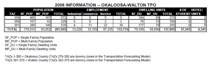
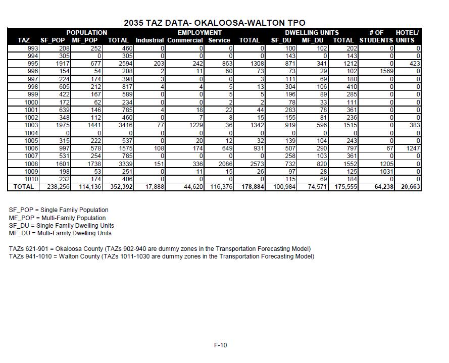
12 It is not uncommon to set aside a specific range of TAZ numbers for both TAZs and dummy zones for each county. This allows the model users to differentiate between counties. The TPO Staff created additional TAZs countywide for Okaloosa and Walton Counties. Okaloosa County TAZs are numbered , the created dummy TAZs are The TAZs in Walton County are numbered TAZs are dummy zones created in Walton County. TRAFFIC ANALYSIS ZONE (TAZ) DATA DEVELOPMENT The socioeconomic data presented in this report consists of five (5) basic variables: population, employment, dwelling units, hotel/motel units, and school enrollment. In this section, the purpose of the variables in zonal trip generation will be explained. The methodology used in developing the base year (2006) and forecast year (2035) data will also be explained. The Okaloosa-Walton data needs are established by the Florida Department of Transportation (FDOT) input requirements to the standard trip generation model (The Northwest Regional Planning Model). To run the model, three (3) data files are required to replicate 2006 base year trips and forecast future year trips. These files are: 1. ZONEDATA - Trip Production and attraction data, 2. SPECGEN- Special Generation data, and 3. INTEXT - Internal-External trip productions. The ZONEDATA files provide data necessary for the trip generation model to calculate the number of trips "produced" by each TAZ. Production data include TAZ population, dwelling units, hotel/motel units, and auto availability. The main sources of data for this file are the 2000 census, the University of Florida Bureau of Economic and Business Research (BEBR), and the Florida Department of Business Regulation. The number of trips "attracted" to each TAZ is computed by the trip generation model. Attraction data includes employment and school enrollment. The primary sources of data for this file are InfoUSA, and local school boards, as well as, local universities and community colleges. Special generators are input through the SPECGEN file. Special generators represent production Okaloosa-Walton Data Report 2035 Plan Update 7
13 or attraction data for particular land uses which have unusual trip making characteristics that are not reflected in the trip generation model. An example is Eglin Air Force Base. Finally, trip production data necessary to determine the number of trips originating inside the study area, with a designation outside the area, is referred to as Internal-External trip production (INTEXT). Each of the five (5) basic data variables contained in this report is defined below: 1. Population - Population categories include permanent year round residents living in single family or multi-family housing units, as defined below. 2. Dwelling Units - Dwelling unit categories include single and multi-family, year-round, and seasonal housing units. Single-family units are defined as detached one family homes; multi-family units are represented by two or more family structures and mobile homes. Mobile home dwelling units are included in this category because their trip making characteristics are very similar to multi-family units. The multi-family category also includes condominiums but not hotels and motels. Multi-family units are counted by family units not structures. 3. Employment - Employment categories include industrial, commercial, and service. Industrial employment generally includes manufacturing and construction activities. Commercial employment is represented by retail and wholesale product sales activities such as department store and grocery store employment. Service employment includes activities which are service oriented such as school and restaurant employment. Military employment is also included in the service category. All employment is located by place of work. 4. Hotel/Motel Units - This data variable includes nonpermanent resident housing units for transients. Units are counted by total number of rooms. 5. School Enrollment - This data variable includes public schools, senior colleges, vocational/technical, and private school enrollment that are assigned by school location. Okaloosa-Walton Data Report Plan Update
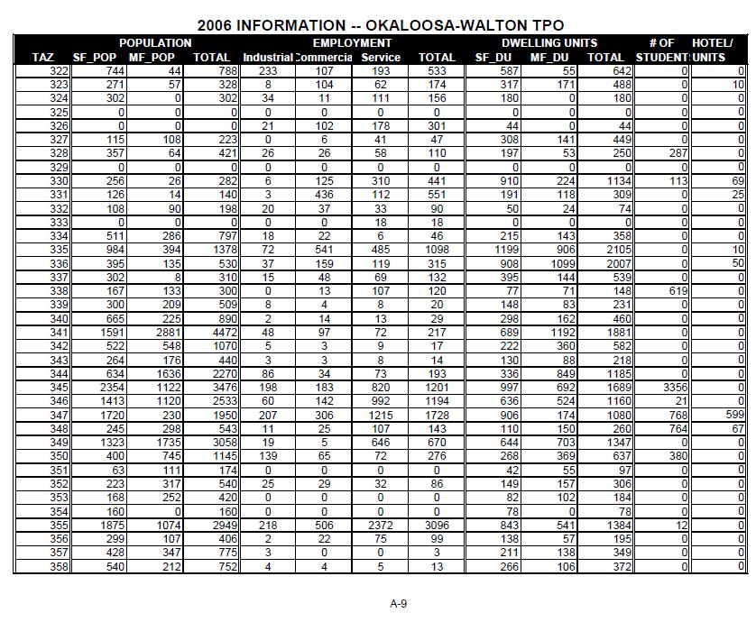
14 Base Year Data Development How the 2006 Base Year data for each socioeconomic variable was developed is explained in this section. It should be noted that 2000 Census data was utilized in development of the base year socioeconomic data. Dwelling Units Development of the 2006 Base Year single and multi-family estimated dwelling unit totals for each TAZ involved establishing a base from the 2000 Census data tracts. The number of building permits issued in each TAZ was then added to the 2000 Census data to obtain the number of dwelling units in each TAZ in In the Long Range Transportation Plan Study Area, dwelling unit totals for the 2006 base year were established at 79,109 single family units and 58,696 multi-family and mobile home units. For the purposes of this study, all condominium units are included in the multi-family category. Population Development of single family and multi-family 2006 Base Year population totals for each TAZ in the Long Range Transportation Plan Study Area was accomplished by using the 2000 Census Data and the 2006 base year dwelling units. Occupancy and persons per household rates from the 2000 Census for single family and multi-family dwelling units were determined for each zone. These rates were applied to the corresponding 2006 Base Year dwelling unit totals for each TAZ to derive the 2006 estimated population figures. The total population of the study area was 261,065 in Employment Employment data was obtained from InfoUSA and assigned to TAZs based on employer address. InfoUSA is proprietary database that provides spatially enabled employment data with information related to the classification and size of the business establishments. After the employment data was assigned, it was disaggregated into three employment categories commercial, service, and industrial. The disaggregation was accomplished by using Standard Industrial Classification Manual (1987) codes. The SIC codes are for Industrial Employment, for Commercial Employment, and and for Service Employment. Okaloosa-Walton Data Report 2035 Plan Update 9
15 In addition, several large employers were contacted directly to obtain their employment, including the Okaloosa County School Board, the Walton County School Board, and Northwest Florida State College. The local military bases and hospitals were also contacted about employment levels, as well as the large industrial employers in the Okaloosa and Walton Counties. Total 2006 employment was estimated to be 33,155 Commercial and 83,335 Service Employees. Industrial employment is estimated to be 13,220. Total 2006 estimated employment was 133,710 jobs. Hotel/Motel Units The data source for hotel/motel information is the Florida Department of Business Regulation and the Division of Hotels and Restaurants, which maintains an up-to-date file on hotels and motels. The file contains the address and number of units for each hotel/motel. This information was obtained and assigned to TAZs in order to generate 2006 base year totals. The total hotel/motel units were estimated to be 6,341 in School Enrollment The Okaloosa and Walton County School Boards were contacted to obtain the location and enrollment for each public school in the study area. The School Boards also had location information on private schools in the study area, and in some cases provided the enrollment. Private schools for which enrollment was not available were contacted directly for their enrollment numbers. The Northwest Florida State College was also contacted directly concerning enrollment levels. The total study area school enrollment in 2006 was estimated to be 57,543 students. Base Year Data Review The base year data was reviewed by the local planning agencies as part of the Land Use Subcommittee that also reviewed the Land Use Scenarios. The Land Use Subcommittee reviewed the base year data at its September 29, 2008, meeting and the TPO Staff noted areas where data assignments needed adjustments. The Okaloosa-Walton TPO Technical Coordinating Committee adopted the 2006 base year data on October 30, 2008, with a request that the methodology be explained. Okaloosa-Walton Data Report 2035 Plan Update 10
16 Land Use Scenarios A committee made up of local planners and FDOT, Eglin Air Force Base and Hurlburt Field representatives met with Transportation Planning Services, Inc., a sub consultant to the TPO and with TPO Staff four times over a period of six months. The purpose of the meetings was to develop a final data set for the forecast Year Two land use alternatives were set up and evaluated using the Urban Land Use Allocation Model. The committee reviewed the results. The Urban Land Use Allocation Model provides the TPO with a systematic approach that uses the most current land use information to generate the future year socioeconomic data. The model utilizes parcel-level land use data and converts that data to traffic zone based information about vacant land, densities and approved development. The purpose of the Urban Land Use Allocation Model is to automatically allocate future growth in the form of regional or county-wide population and employment control totals at the TAZ level, producing data files for input into the travel forecasting model. The first step in the land use scenario process involves the development of a Trend Scenario. The Trend Scenario illustrates the build-out potential of the region by 2035 based on existing land use policies and development patterns. It gives a frame of reference as to what development trends have been occurring in recent years. The trend was identified using information found in the property appraiser data for each county. Using the existing use code and effective year built information in the parcel data file for each county, the net increase in dwelling units and commercial square footage was identified for each traffic zone and used in establishing the historical trend regarding how growth has been geographically occurring in the study area. Working with the Land Use Subcommittee, a second land use alternative was developed and tested for the TPO study area. The second land use evaluated was the compact land use alternative, also known as the infill scenario. A detailed Land Use Alternative Technical Report will be included in the Okaloosa-Walton Transportation Outlook 2035 Long Range Transportation Plan. It was determined by the Land Use Subcommittee that Trend Scenario or Historical Trend alternative be used for the development of the 2035 Long Range Transportation Plan; the land use alternative used to forecast the 2035 land use data that is needed to run the traffic forecasting model. The Okaloosa-Walton Data Report 2035 Plan Update 11
17 Okaloosa-Walton TPO adopted the historical trend as the preferred Land Use Alternative for 2035 on February 17, 2011, by Resolution O-W Historical Trend Analysis Using the parcel data and available current zoning information for Okaloosa and Walton Counties and municipalities and towns, a land use alternative was developed to reflect the historical growth patterns of the area. Designated wetlands and environmentally constrained areas were filtered out of the results. The most recent employment and resident population growth estimates expected as a result of the 2005 Base Realignment and Closure (BRAC) recommendation were used to increase the resident population by 14,006 in selected Traffic Analysis Zones within Eglin Air Force Base. In allocating growth 25 to 30 years into the future, it is not uncommon to have a situation where there is not enough vacant land to support the projected population or employment control totals. In those cases, agriculture is sometimes rezoned to increase the inventory of vacant buildable land. The following criteria is used to identify agricultural land that may be rezoned and developed: vacant parcels in the Urban Growth Boundary, within the water and sewer service area, non-agricultural adjoining land uses, within a major travel corridor, or a high growth area. The Future Land Use Map (FLUM) from the comprehensive plan for each county was used to identify parcels that are currently zoned agriculture or timberland but have a future land use that would allow those parcels to be rezoned in the future. Compact Development (Infill Development) This alternative is designed to create moderate density activity nodes that can be served by transportation and other infrastructure in a more efficient and cost effective manner. This alternative land use was created by increasing the density and intensity of use and creating a better job/housing mix of 40 and 60 percent, respectively in those areas. Okaloosa-Walton Data Report 2035 Plan Update 12
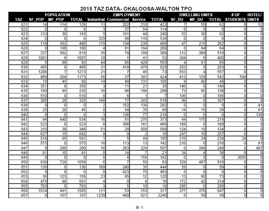
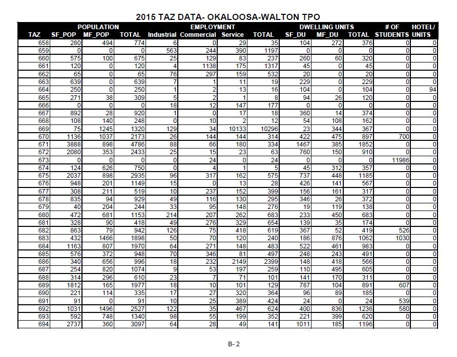
18 Forecast Years Data Development Once the preferred 2035 Land Use Alternative was agreed upon, interim projections from the Urban Land Use Allocation (ULAM) model could be generated. The ULAM provides the TPO with a systematic approach that uses the most current land use information to generate the future years socioeconomic data needed as input into the travel forecasting model. By improving the quality of the future year land use data, the TPO can help ensure that the travel projections uses in the development of the long range transportation plan accurately reflect the future transportation In addition to the 2035 data, the interim years selected from ULAM and designated in the Scope of Services were 2015, 2025 and The following are the data identified: Population, Dwelling Units, Employment, Hotel/Motel Units, and School Enrollment. Housing Data Each TAZ was reviewed, and the land uses, density and intensity levels, and number of developable acres were determined. Local Government Comprehensive Plans were used to determine the type and density of development allowed in each zone. A ratio between the 2006 base year housing data by type (single family or multi-family) and the total number of dwelling units developed a ratio between the total number of dwelling units and the number of single family, multi-family units, and mobile homes for each TAZ. This ratio was developed by taking, as an example, the 2006 base year number for single family dwelling units in a TAZ and dividing it by the total number of single family dwelling units for the study area within the county. This produces a ratio of dwelling units in the TAZ to total dwelling units. Once the ratio was determined for each TAZ, it was multiplied by the actual projected growth for single-family dwelling units, which was established by the dwelling units control totals. This number was then added back into the base year single-family dwelling unit number to determine the year 2006 single-family dwelling unit projection for the TAZ. Once this was complete, each TAZ was checked to ensure a reasonable number of dwelling units was assigned based on local comprehensive plans. This was done for each forecast year (2015, 2020, 2025, 2030 and 2035). Any adjustments, which were necessary, were done manually. In other words, if the methodology described above over or under assigned units to a particular zone, an appropriate number of units was subtracted out or added into the TAZ. The same number of units would then be added or subtracted from another TAZ where too many or too few units were assigned. Okaloosa-Walton Data Report 2035 Plan Update 13
19 Listed in Table 1 is the forecast year single and multi-family housing data for the Long Range Transportation Plan Study area. The projected number of single-family dwelling units in 2015 is less than the 2006 estimate of the number of units. This decrease can be attributed to an overall decline in the number of new units built from The population is projected to increase over the study period, and thus increase the need for new single-family units but at a smaller percentage than was estimated in The region continues to struggle with the downturn in the economy. TABLE 1 - FORECAST YEAR DWELLING UNIT PROJECTIONS BY UNIT TYPE BY LONG RANGE TRANSPORTATION PLAN STUDY AREA Unit Type Base Year Forecast Year Single Family 79,109 78,068 84,590 90,297 95, ,984 *Multi Family 58,696 60,732 64,580 68,086 71,347 74,571 * Multi Family Units include mobile home units. Trips associated with mobile home units is considered similar to trips associated with multi-family units. Employment Data The employment forecasts were developed using the same methodology as the housing forecasts. The TPO Staff began with the ratio of 2006 TAZ employment, by type (service, industrial, and commercial), to total study area employment by county. This ratio was then multiplied by the actual projected growth, which was established by the employment control totals. The outcome is then added back into the base year employment number to come up with the 2006 projections for each TAZ. Once the employment forecasts were developed, the TPO Staff checked each TAZ to ensure a reasonable amount of employment had been allocated to the zone. As with the dwelling unit forecasts, any adjustments, which were needed, were done manually. Okaloosa-Walton Data Report 2035 Plan Update 14
20 forecast years. Listed in Table 2 are the Long Range Transportation Plan Study Area employment data for the TABLE 2 - FORECAST YEAR EMPLOYMENT PROJECTIONS BY EMPLOYMENT TYPE BY LONG RANGE TRANSPORTATION PLAN STUDY AREA Employment Type Base Year Forecast Year Industrial 13,220 13,805 14,895 15,949 16,931 17,888 Commercial 33,155 34,517 37,220 39,826 42,259 44,460 Service 87,335 90,731 97, , ,376 Population Data The forecast year population data were developed by taking the total number of dwelling units in each TAZ for each forecast year and multiplying it by the vacancy rate, which determines the total number of occupied housing units in each TAZ. This number is then multiplied by the persons per household rate for each TAZ. The outcome is the estimated population by TAZ. The number of households is derived from the dwelling unit forecasts discussed previously and the vacancy rates are developed from the 2000 Census data. This method is used for each TAZ for each of the forecast years (2015, 2020, 2025, 2030 and 2035). This resulted in the population projections for the Long Range Transportation Plan Study Area shown in Table 3. TABLE 3 - FORECAST YEAR POPULATION PROJECTIONS BY LONG RANGE TRANSPORTATION PLAN STUDY AREA Population by Base Year Forecast Year Housing Type Single Family 178, , , , , ,256 Multi-Family 83,052 87,184 94, , , ,136 Total 261, , , , , ,392 Okaloosa-Walton Data Report 2035 Plan Update 15
21 Hotel/Motel Units Table 4 shows the Hotel/Motel projections for the Long Range Transportation Plan Study Area. TABLE 4 - FORECAST YEAR HOTEL/MOTEL PROJECTIONS BY LONG RANGE TRANSPORTATION PLAN STUDY AREA Hotel/Motel Units Base Year Forecast Year Number 6,341 15,993 17,332 18,491 19,584 20,663 School Enrollment School enrollment forecast year data were developed and manually allocated to each TAZ. The county school board was contacted directly and questioned about their anticipated growth in enrollment. Information concerning the location and enrollment of any new schools was also obtained from the school board. Northwest Florida State College was also contacted to determine forecast year enrollment levels. Listed in Table 5 is the forecast school enrollment for the Long Range Transportation Plan Study Area. The projected number of students in 2015 is less than the 2006 estimate of the number of enrolled students. This decrease can be attributed to an overall decline in population from The population is projected to increase over the study period but at a smaller percentage than was estimated in 2006, and at a smaller rate than the population increase. The Okaloosa County School Board representative projected that the number of students would increase at a rate that is 25 percent less than the general increase in population. TABLE 5 - FORECAST SCHOOL ENROLLMENT PROJECTIONS BY LONG RANGE TRANSPORTATION PLAN STUDY AREA School Enrollment Number of Students Base Year Forecast Year ,543 53,553 56,222 58,892 61,565 64,238 Okaloosa-Walton Data Report 2035 Plan Update 16
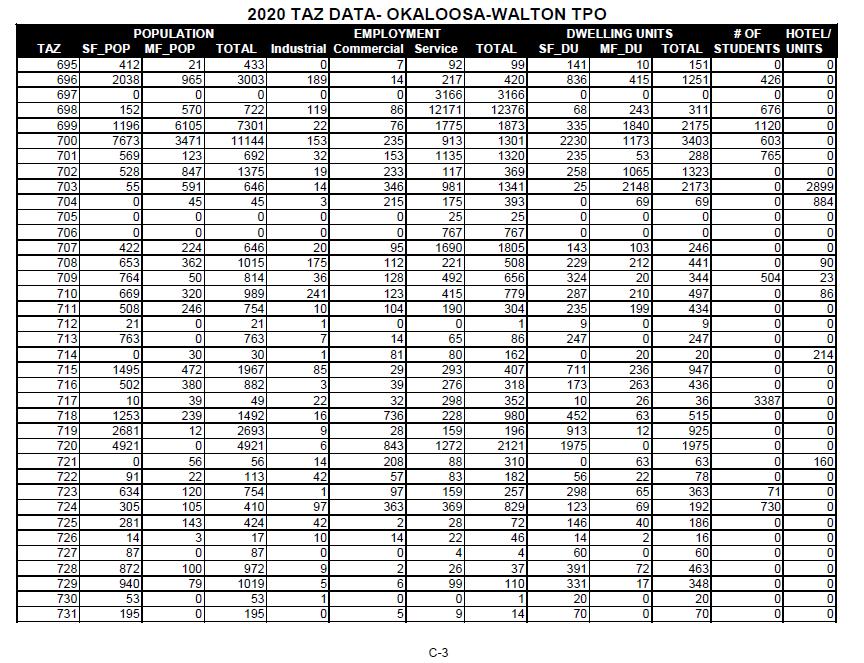
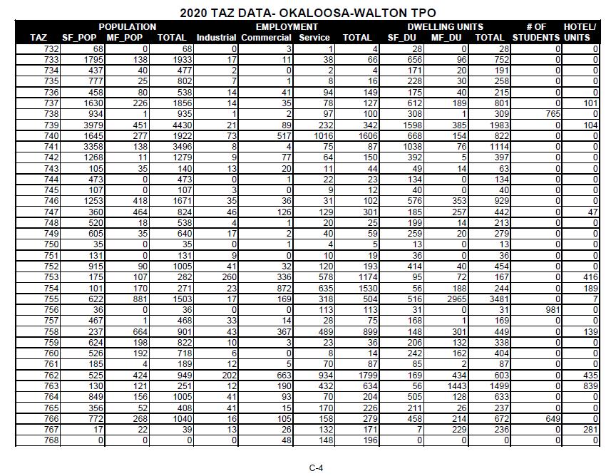
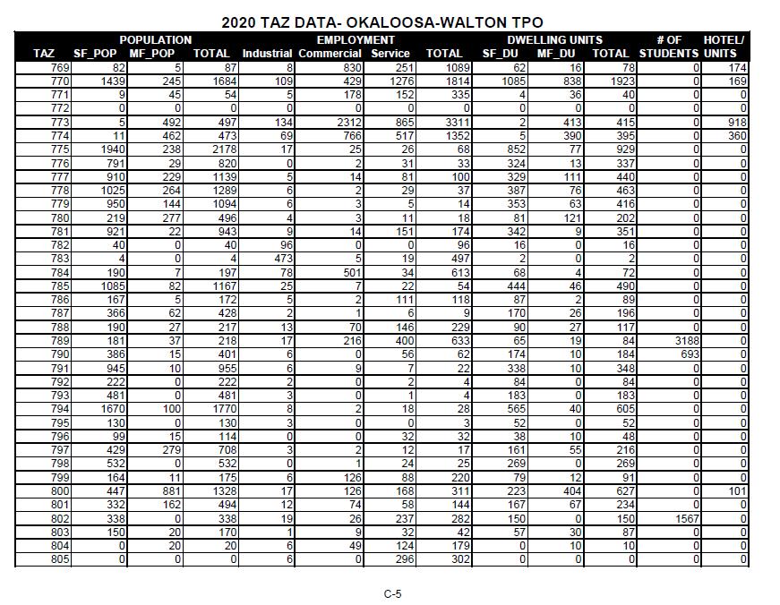
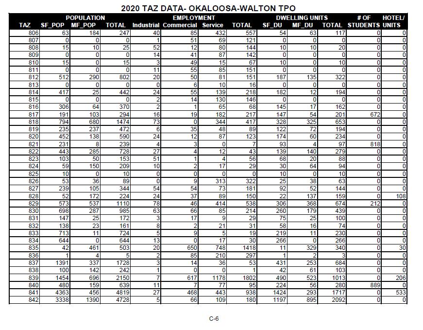
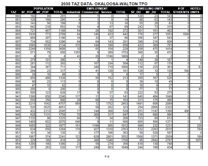
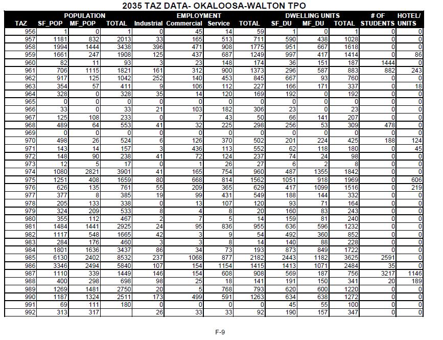
22 TRAFFIC ANALYSIS ZONE (TAZ) STATISTICAL DATA The tables in the appendices contain the 2006 base year and forecast 2015, 2020, 2025, 2030, and 2035 data sets. These are all inputs to the regional transportation model. It is emphasized that these data were developed for TPO transportation planning purposes. This information is not intended to be a land use plan for any part of the urban area. Okaloosa-Walton Data Report 2035 Plan Update 17
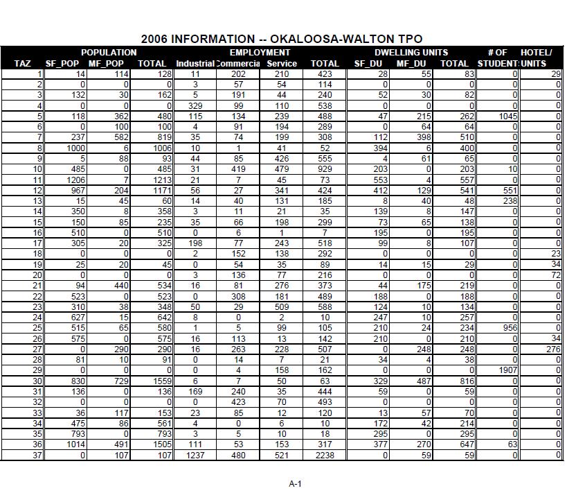
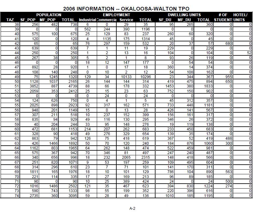
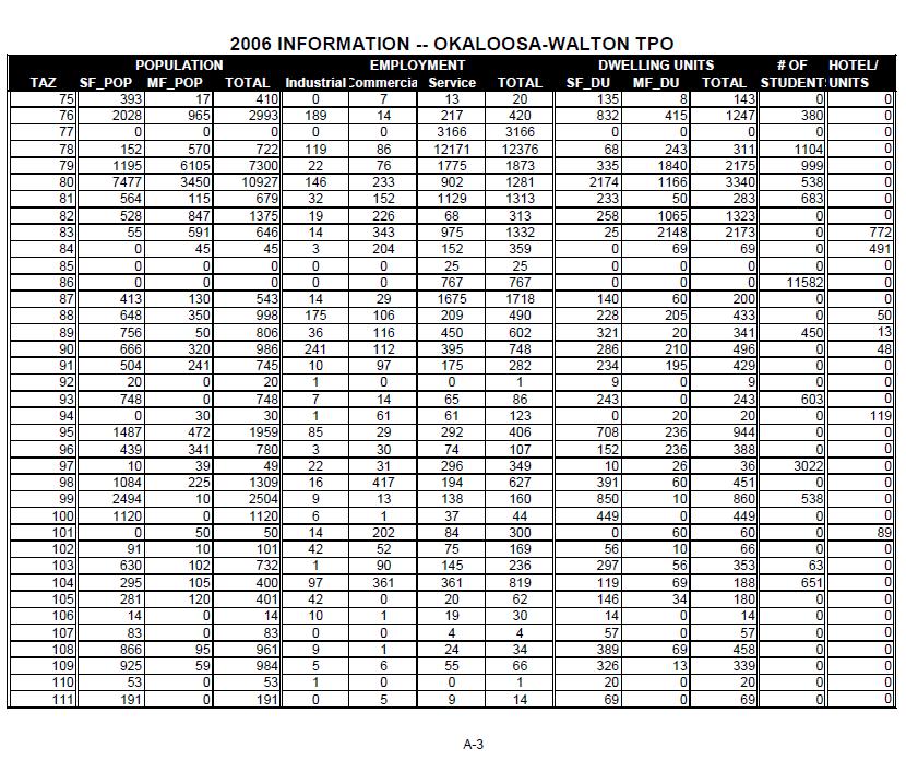
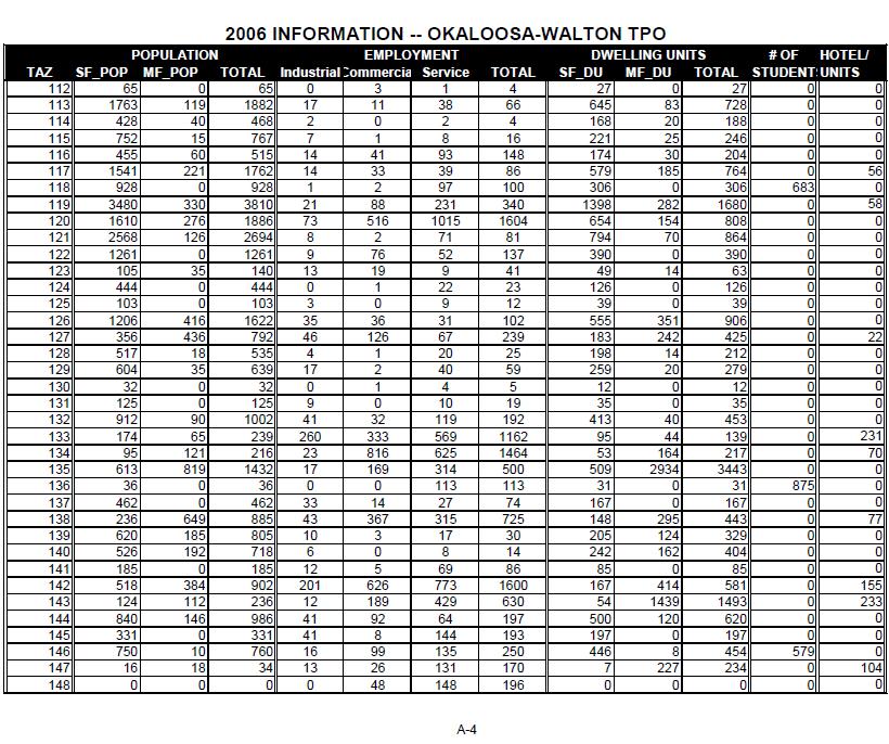
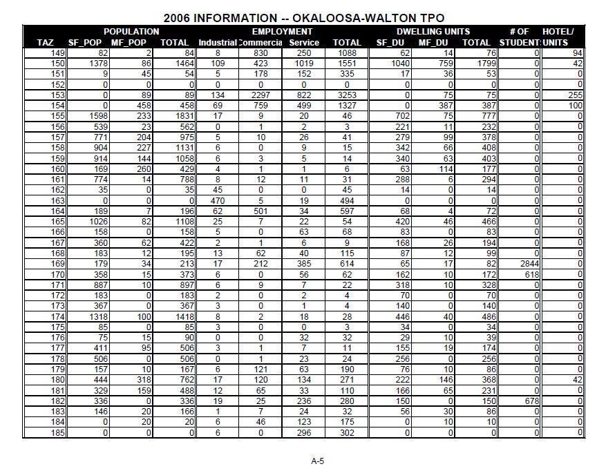
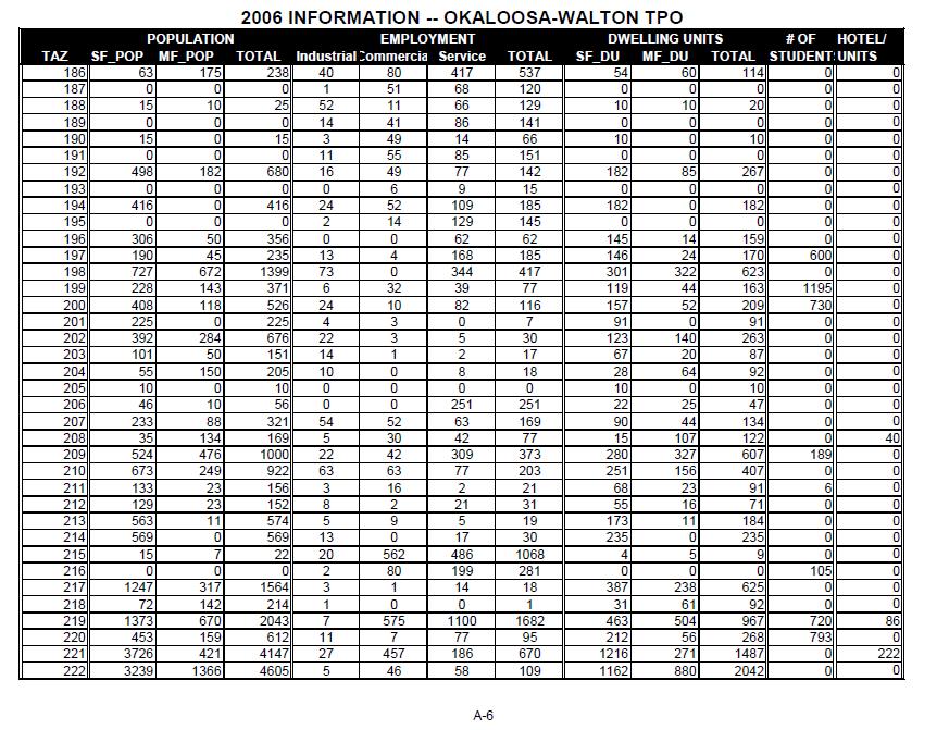
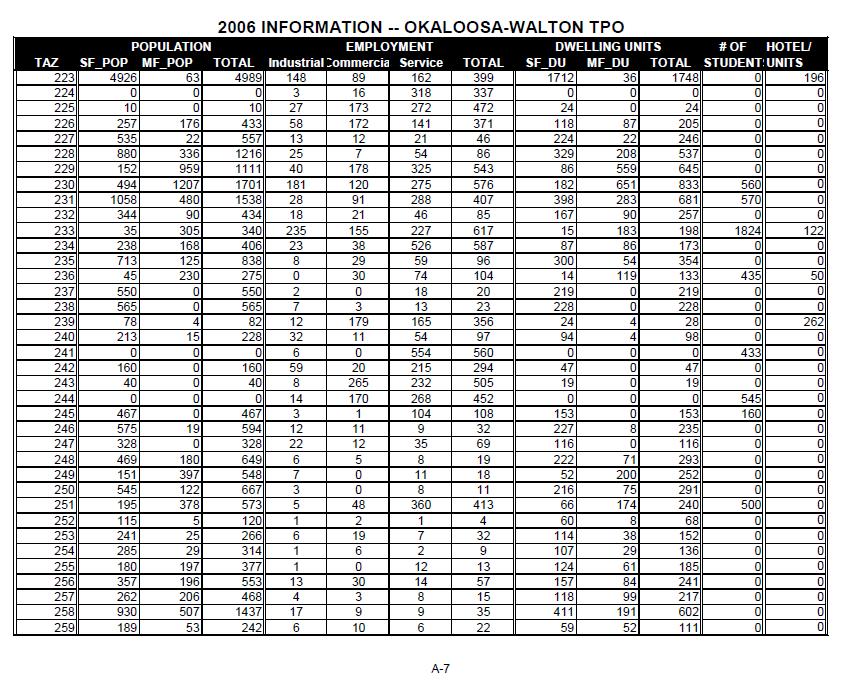
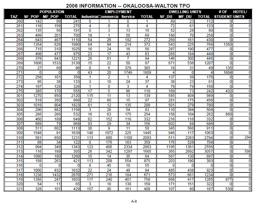
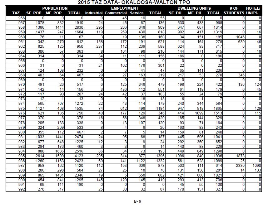
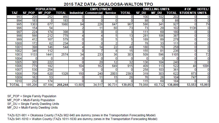
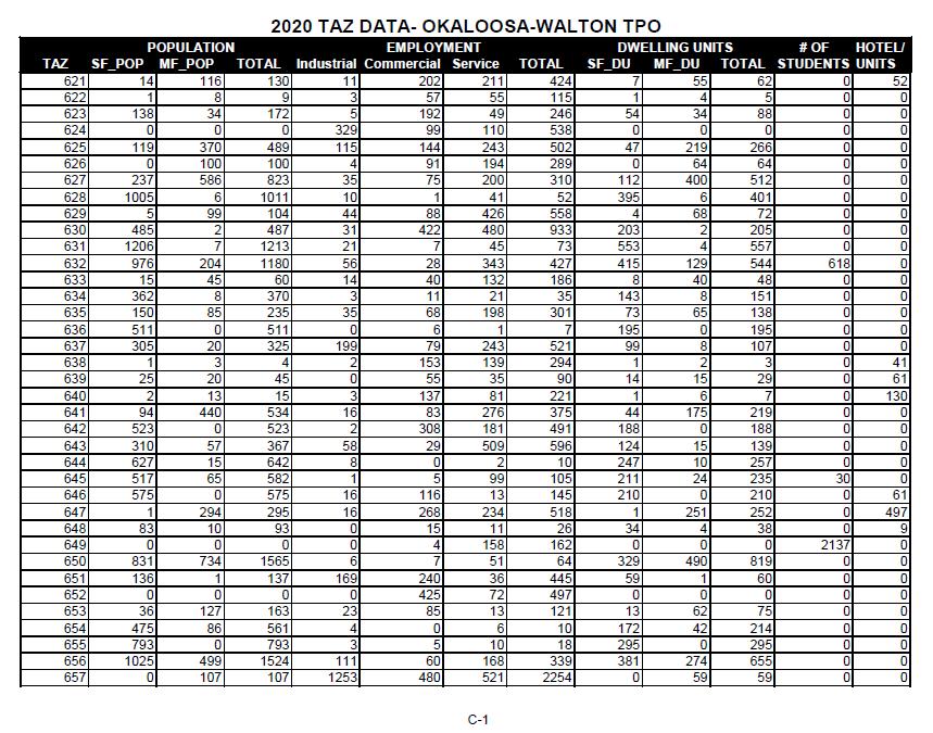
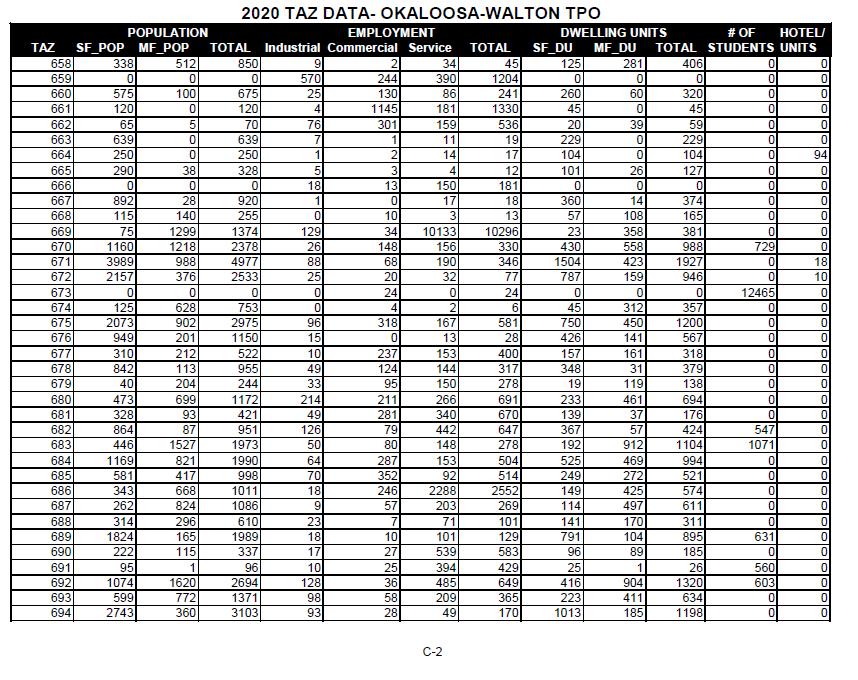
23 APPENDIX A 2006 BASE YEAR DATA BY TRAFFIC ANALYSIS ZONE (TAZ)
24
25
26
27
28
29
30
31
32
33
34 APPENDIX B 2015 DATA BY TRAFFIC ANALYSIS ZONE (TAZ)
35
36
37
38

39
40
41

42
43
44
45 APPENDIX C 2020 DATA BY TRAFFIC ANALYSIS ZONE (TAZ)
46
47
48
49
50
51
52

53
54
55
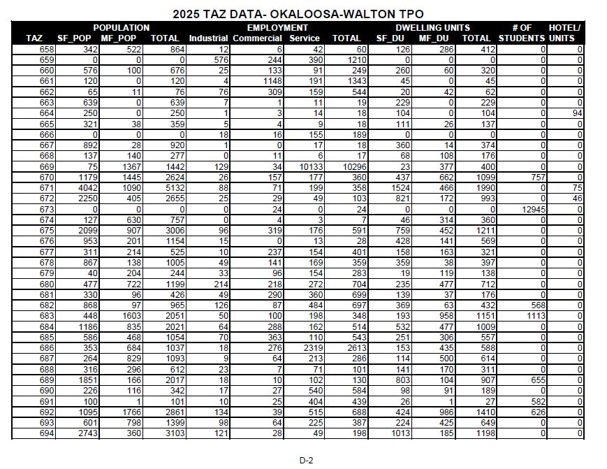
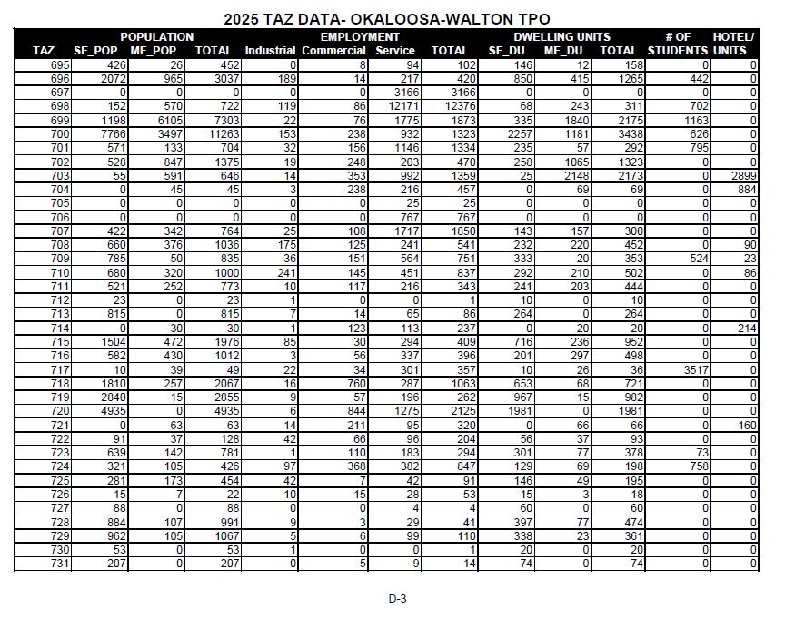
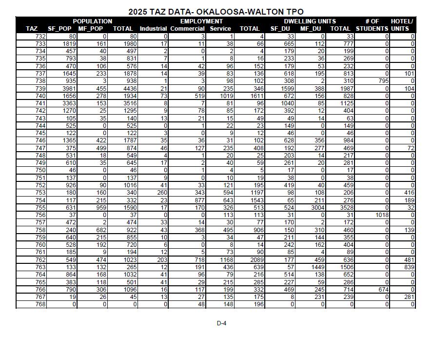
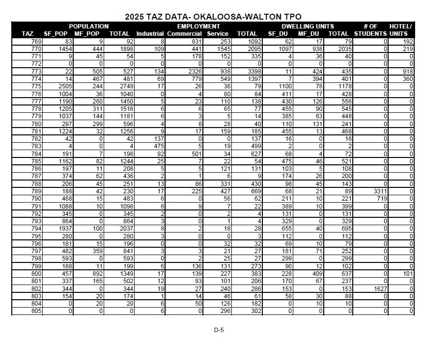
56 APPENDIX D 2025 DATA BY TRAFFIC ANALYSIS ZONE (TAZ)
57
58
59
60
61
62
63
64
65

66
67 APPENDIX E 2030 DATA BY TRAFFIC ANALYSIS ZONE (TAZ)
68
69
70
71

72
73

74
75
76
77
78 APPENDIX F 2035 DATA BY TRAFFIC ANALYSIS ZONE (TAZ)

79
80
81

82
83

84
85
86
87
88
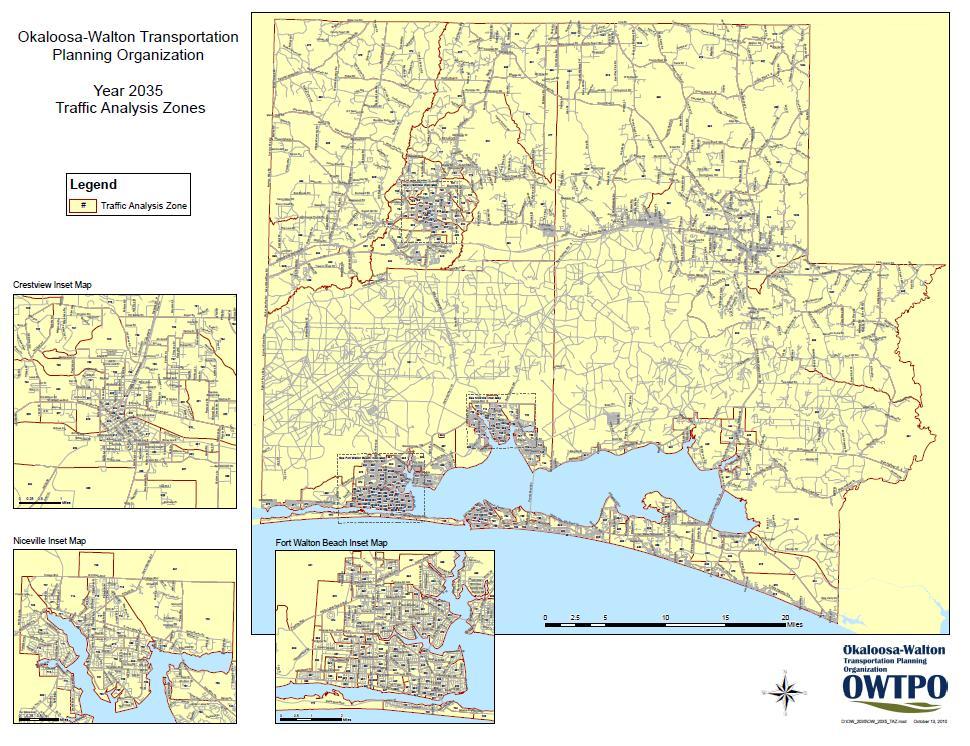
89 APPENDIX G Traffic Analysis Zone (TAZ) Map
90
HORIZON 2030: Land Use & Transportation November 2005
 PROJECTS Land Use An important component of the Horizon transportation planning process involved reviewing the area s comprehensive land use plans to ensure consistency between them and the longrange transportation
TABLE OF CONTENTS Page 1.0 Introduction 2.0 Data Review 3.0 Land Use Model Development 4.0 Allocation Results 5.0 Land Use Alternative
 i ii TABLE OF CONTENTS Page 1.0 Introduction... 1 2.0 Data Review... 4 3.0 Land Use Model Development... 5 3.1 Base Year Data... 5 3.2 Highway Networks... 5 3.3 ULAM Default Values... 5 3.4 Population
PINELLAS COUNTY METROPOLITAN PLANNING ORGANIZATION FORECAST 2035 EMPLOYMENT SOCIOECONOMIC DATA FINAL REPORT
 PINELLAS COUNTY METROPOLITAN PLANNING ORGANIZATION FORECAST 2035 EMPLOYMENT SOCIOECONOMIC DATA FINAL REPORT PREPARED FOR: Pinellas County Metropolitan Planning Organization 600 Cleveland Street, Suite
TRAVEL DEMAND MODEL. Chapter 6
 Chapter 6 TRAVEL DEMAND MODEL As a component of the Teller County Transportation Plan development, a computerized travel demand model was developed. The model was utilized for development of the Transportation
APPENDIX IV MODELLING
 APPENDIX IV MODELLING Kingston Transportation Master Plan Final Report, July 2004 Appendix IV: Modelling i TABLE OF CONTENTS Page 1.0 INTRODUCTION... 1 2.0 OBJECTIVE... 1 3.0 URBAN TRANSPORTATION MODELLING
APPENDIX I: Traffic Forecasting Model and Assumptions
 APPENDIX I: Traffic Forecasting Model and Assumptions Appendix I reports on the assumptions and traffic model specifications that were developed to support the Reaffirmation of the 2040 Long Range Plan.
Expanding the GSATS Model Area into
 Appendix A Expanding the GSATS Model Area into North Carolina Jluy, 2011 Table of Contents LONG-RANGE TRANSPORTATION PLAN UPDATE 1. Introduction... 1 1.1 Background... 1 1.2 Existing Northern Extent of
Trip Generation Model Development for Albany
 Trip Generation Model Development for Albany Hui (Clare) Yu Department for Planning and Infrastructure Email: hui.yu@dpi.wa.gov.au and Peter Lawrence Department for Planning and Infrastructure Email: lawrence.peter@dpi.wa.gov.au
Technical Memorandum #2 Future Conditions
 Technical Memorandum #2 Future Conditions To: Dan Farnsworth Transportation Planner Fargo-Moorhead Metro Council of Governments From: Rick Gunderson, PE Josh Hinds PE, PTOE Houston Engineering, Inc. Subject:
Kitsap County 2016 Comprehensive Plan Update. Appendix A: Growth Estimates
 Kitsap County 2016 Comprehensive Plan Update Appendix A: Growth Estimates Appendix A 1 April 2016 Kitsap County 2016 Comprehensive Plan Update Appendix A: Growth Estimates Land Capacity Land capacity
Wasatch Front Region Small Area Socioeconomic Forecasts: Technical Report #49
 Regional Transportation Plan: 2011-2040 Appendix A APPENDIX A Wasatch Front Region Small Area Socioeconomic Forecasts: 2007-2040 Technical Report #49 July, 2010 295 N. Jimmy Doolittle Road Salt Lake City,
Appendixx C Travel Demand Model Development and Forecasting Lubbock Outer Route Study June 2014
 Appendix C Travel Demand Model Development and Forecasting Lubbock Outer Route Study June 2014 CONTENTS List of Figures-... 3 List of Tables... 4 Introduction... 1 Application of the Lubbock Travel Demand
Wasatch Front Region Small Area Socioeconomic Forecasts: Technical Report #49
 Wasatch Front Region Small Area Socioeconomic Forecasts: 2007-2040 Technical Report #49 July, 2010 Wasatch Front Regional Council 295 N. Jimmy Doolittle Road Salt Lake City, UT 84116 P (801) 363-4250 F
PIBC Annual Conference, 2016
 Land Use Quantified PIBC Annual Conference, 2016 A collaboration between: Christy & Associated Planning Consultants The Sustainable Transportation Partnership of the Central Okanagan Hazel Christy Rafael
3.0 ANALYSIS OF FUTURE TRANSPORTATION NEEDS
 3.0 ANALYSIS OF FUTURE TRANSPORTATION NEEDS In order to better determine future roadway expansion and connectivity needs, future population growth and land development patterns were analyzed as part of
final report A Recommended Approach to Delineating Traffic Analysis Zones in Florida Florida Department of Transportation Systems Planning Office
 A Recommended Approach to Delineating Traffic Analysis Zones in Florida final report prepared for Florida Department of Transportation Systems Planning Office September 27, 2007 final report A Recommended
Forecasts for the Reston/Dulles Rail Corridor and Route 28 Corridor 2010 to 2050
 George Mason University Center for Regional Analysis Forecasts for the Reston/Dulles Rail Corridor and Route 28 Corridor 21 to 25 Prepared for the Fairfax County Department of Planning and Zoning Lisa
GROWTH MANAGEMENT REPORT Wiarton South Settlement Area
 GROWTH MANAGEMENT REPORT Wiarton South Settlement Area Designations in the Town of Wiarton Prepared for: The Municipality of South Bruce Peninsula P.O. Box 310 315 George St. Wiarton, ON N0H 2T0 Prepared
Changes in the Spatial Distribution of Mobile Source Emissions due to the Interactions between Land-use and Regional Transportation Systems
 Changes in the Spatial Distribution of Mobile Source Emissions due to the Interactions between Land-use and Regional Transportation Systems A Framework for Analysis Urban Transportation Center University
BROOKINGS May
 Appendix 1. Technical Methodology This study combines detailed data on transit systems, demographics, and employment to determine the accessibility of jobs via transit within and across the country s 100
Date: June 19, 2013 Meeting Date: July 5, Consideration of the City of Vancouver s Regional Context Statement
 Section E 1.5 To: From: Regional Planning and Agriculture Committee Lee-Ann Garnett, Senior Regional Planner Planning, Policy and Environment Department Date: June 19, 2013 Meeting Date: July 5, 2013 Subject:
MPOs SB 375 LAFCOs SCAG Practices/Experiences And Future Collaborations with LAFCOs
 Connecting LAFCOs and COGs for Mutual Benefits MPOs SB 375 LAFCOs SCAG Practices/Experiences And Future Collaborations with LAFCOs Frank Wen, Manager Research & Analysis Land Use & Environmental Planning
Lee County, Florida 2015 Forecast Report Population, Housing and Commercial Demand
 Lee County, Florida 2015 Forecast Report Population, Housing and Commercial Demand Thank you for purchasing this report, which contains forecasts of population growth, housing demand and demand for commercial
5.0 POPULATION, HOUSEHOLD AND EMPLOYMENT FORECASTS
 5.0 POPULATION, HOUSEHOLD AND EMPLOYMENT FORECASTS 5.1 Hemson Consulting Ltd. Forecasts Hemson Consulting Ltd. was retained in 03 to prepare new growth projections for the County as part of its Official
Date: March 31, 2014 PATE; fyril 2.3,2 >H
 aj BRAMPTON fifs Rower City XH-l-f r.t "»* City Council The Corporation of the City of Brampton SRAMPTON CITY COUNCIL Date: March 31, 2014 PATE; fyril 2.3,2 >H File: POO GR VisWhtoJed ^t'th-meeh'^a Subject:
Population Trends Along the Coastal United States:
 Coastal Trends Report Series Population Trends Along the Coastal United States: 1980-2008 U.S. Department of Commerce National Oceanic and Atmospheric Administration National Ocean Service Assessing the
Lee County, Alabama 2015 Forecast Report Population, Housing and Commercial Demand
 Lee County, Alabama 2015 Forecast Report Population, Housing and Commercial Demand Thank you for purchasing this report, which contains forecasts of population growth, housing demand and demand for commercial
Cipra D. Revised Submittal 1
 Cipra D. Revised Submittal 1 Enhancing MPO Travel Models with Statewide Model Inputs: An Application from Wisconsin David Cipra, PhD * Wisconsin Department of Transportation PO Box 7913 Madison, Wisconsin
Regional Performance Measures
 G Performance Measures Regional Performance Measures Introduction This appendix highlights the performance of the MTP/SCS for 2035. The performance of the Revenue Constrained network also is compared to
TREASURE COAST REGIONAL PLANNING COUNCIL M E M O R A N D U M. To: Council Members AGENDA ITEM 4B10
 TREASURE COAST REGIONAL PLANNING COUNCIL M E M O R A N D U M To: Council Members AGENDA ITEM 4B10 From: Date: Subject: Staff December 14, 2018 Council Meeting Local Government Comprehensive Plan Review
APPLICATION TO AMEND THE FUTURE LAND USE MAP (FLUM) SMALL SCALE
 SMALL SCALE") DEPARTMENT OF DEVELOPMENT & PLANNING 825 Ohio Avenue - Lynn Haven, FL 32444 (850) 265-2961 - (850) 265-3478 APPLICATION TO AMEND THE FUTURE LAND USE MAP (FLUM) SMALL SCALE Deadline to submit is 30 days
DEPARTMENT OF DEVELOPMENT & PLANNING 825 Ohio Avenue - Lynn Haven, FL 32444 (850) 265-2961 - (850) 265-3478 APPLICATION TO AMEND THE FUTURE LAND USE MAP (FLUM) SMALL SCALE Deadline to submit is 30 days
StanCOG Transportation Model Program. General Summary
 StanCOG Transportation Model Program Adopted By the StanCOG Policy Board March 17, 2010 What are Transportation Models? General Summary Transportation Models are technical planning and decision support
APPENDIX C-3 Equitable Target Areas (ETA) Technical Analysis Methodology
 Technical Analysis Methodology") APPENDIX C-3 Equitable Target Areas (ETA) Technical Analysis Methodology Contents Introduction... 1 ETA Index Methodology... 1 ETA Index Development... 1 Other EJ Measures... 4 The Limited English Proficiency
APPENDIX C-3 Equitable Target Areas (ETA) Technical Analysis Methodology Contents Introduction... 1 ETA Index Methodology... 1 ETA Index Development... 1 Other EJ Measures... 4 The Limited English Proficiency
Volume Title: Empirical Models of Urban Land Use: Suggestions on Research Objectives and Organization. Volume URL:
 This PDF is a selection from an out-of-print volume from the National Bureau of Economic Research Volume Title: Empirical Models of Urban Land Use: Suggestions on Research Objectives and Organization Volume
III. FORECASTED GROWTH
 III. FORECASTED GROWTH In order to properly identify potential improvement projects that will be required for the transportation system in Milliken, it is important to first understand the nature and volume
City of Hermosa Beach Beach Access and Parking Study. Submitted by. 600 Wilshire Blvd., Suite 1050 Los Angeles, CA
 City of Hermosa Beach Beach Access and Parking Study Submitted by 600 Wilshire Blvd., Suite 1050 Los Angeles, CA 90017 213.261.3050 January 2015 TABLE OF CONTENTS Introduction to the Beach Access and Parking
Regional Performance Measures
 G Performance Measures Regional Performance Measures Introduction This appendix highlights the performance of the MTP/SCS for 2035. The performance of the Revenue Constrained network also is compared to
California Urban Infill Trip Generation Study. Jim Daisa, P.E.
 California Urban Infill Trip Generation Study Jim Daisa, P.E. What We Did in the Study Develop trip generation rates for land uses in urban areas of California Establish a California urban land use trip
Public Transportation Infrastructure Study (PTIS) - 2 nd Technical Advisory Committee Meeting
 - 2 nd Technical Advisory Committee Meeting") Public Transportation Infrastructure Study (PTIS) - 2 nd Technical Advisory Committee Meeting Presentation to: Technical Advisory Committee (TAC) Presented by: and Team July 8th, 2009 Public Transportation
Public Transportation Infrastructure Study (PTIS) - 2 nd Technical Advisory Committee Meeting Presentation to: Technical Advisory Committee (TAC) Presented by: and Team July 8th, 2009 Public Transportation
FHWA Planning Data Resources: Census Data Planning Products (CTPP) HEPGIS Interactive Mapping Portal
 HEPGIS Interactive Mapping Portal") FHWA Planning Data Resources: Census Data Planning Products (CTPP) HEPGIS Interactive Mapping Portal Jeremy Raw, P.E. FHWA, Office of Planning, Systems Planning and Analysis August 2017 Outline Census
FHWA Planning Data Resources: Census Data Planning Products (CTPP) HEPGIS Interactive Mapping Portal Jeremy Raw, P.E. FHWA, Office of Planning, Systems Planning and Analysis August 2017 Outline Census
Market Street PDP. Nassau County, Florida. Transportation Impact Analysis. VHB/Vanasse Hangen Brustlin, Inc. Nassau County Growth Management
 Transportation Impact Analysis Market Street PDP Nassau County, Florida Submitted to Nassau County Growth Management Prepared for TerraPointe Services, Inc. Prepared by VHB/Vanasse Hangen Brustlin, Inc.
Neighborhood Locations and Amenities
 University of Maryland School of Architecture, Planning and Preservation Fall, 2014 Neighborhood Locations and Amenities Authors: Cole Greene Jacob Johnson Maha Tariq Under the Supervision of: Dr. Chao
Appendix B. Land Use and Traffic Modeling Documentation
 Appendix B Land Use and Traffic Modeling Documentation Technical Memorandum Planning Level Traffic for Northridge Sub-Area Study Office of Statewide Planning and Research Modeling & Forecasting Section
King City URA 6D Concept Plan
 King City URA 6D Concept Plan King City s Evolution Among the fastest growing cities 2000 Census 1,949 2010 Census 3,111 60% increase 2016 Census estimate 3,817 23% increase Average annual rate 4.3% Surpassing
Draft. Butte County Long-Term Regional Growth Forecasts
 Draft Butte County Long-Term Regional Growth Forecasts 2014 2040 Prepared by: November 25 th, 2014 2580 Sierra Sunrise Terrace, Suite 100 Chico, CA 95928 Phone: 530-879-2468 FAX: 530-879-244 www.bcag.org
Traffic Impact Study
 Traffic Impact Study Statham DRI One University Parkway Prepared for: Barrow County Prepared by: October 2012 Table of Contents Executive Summary i Section 1. Introduction 1 Project Description 1 Methodology
Proposed Scope of Work Village of Farmingdale Downtown Farmingdale BOA Step 2 BOA Nomination Study / Draft Generic Environmental Impact Statement
 Proposed Scope of Work Village of Farmingdale Downtown Farmingdale BOA Step 2 BOA Nomination Study / Draft Generic Environmental Impact Statement The scope of work that follows incorporates and covers
Transport Planning in Large Scale Housing Developments. David Knight
 Transport Planning in Large Scale Housing Developments David Knight Large Scale Housing Developments No longer creating great urban spaces in the UK (Hall 2014) Transport Planning Transport planning processes
FSUTMS Framework for Integrating Land Use Modeling
 FSUTMS Framework for Integrating Land Use Modeling presented to MTF Data Committee presented by Wade L. White, Whitehouse Group Walter Anderson, Whitehouse Group March 6, 2012 Agenda Background Previous
Douglas County/Carson City Travel Demand Model
 Douglas County/Carson City Travel Demand Model FINAL REPORT Nevada Department of Transportation Douglas County Prepared by Parsons May 2007 May 2007 CONTENTS 1. INTRODUCTION... 1 2. DEMOGRAPHIC INFORMATION...
Land Use and Zoning Page 1 of 10 LAND USE AND ZONING
 LAND USE AND ZONING Land Use and Zoning Page 1 of 10 BACKGROUND The Clifton-Fruitvale planning area is about 3,962 acres (6.2 sq. miles) with a population of 14,000 residents. The density of the area is
The effects of impact fees on urban form and congestion in Florida
 The effects of impact fees on urban form and congestion in Florida Principal Investigators: Andres G. Blanco Ruth Steiner Presenters: Hyungchul Chung Jeongseob Kim Urban and Regional Planning Contents
Economic Activity Economic A ctivity
 5 Economic Economic Activity Activity ECONOMIC ACTIVITY 5.1 EMPLOYMENT... 5-7 5.1.1 OBJECTIVE... 5-7 5.1.2 POLICIES... 5-7 5.2 PROTECTING THE AREA OF EMPLOYMENT... 5-9 5.2.1 OBJECTIVE... 5-9 5.2.2 POLICIES...
Updating the Urban Boundary and Functional Classification of New Jersey Roadways using 2010 Census data
 Updating the Urban Boundary and Functional Classification of New Jersey Roadways using 2010 Census data By: Glenn Locke, GISP, PMP 1 GIS-T May, 2013 Presentation Overview Purpose of Project Methodology
Developing and Validating Regional Travel Forecasting Models with CTPP Data: MAG Experience
 CTPP Webinar and Discussion Thursday, July 17, 1-3pm EDT Developing and Validating Regional Travel Forecasting Models with CTPP Data: MAG Experience Kyunghwi Jeon, MAG Petya Maneva, MAG Vladimir Livshits,
Application #: TEXT
 TOWN OF FORT MYERS BEACH 2008 PROPOSED COMPREHENSIVE PLAN AMENDMENTS Application #: 2008-13-TEXT Description: Modify the Coastal Management and Future Land Use Elements to reflect the state s new definition
2014 Certification Review Regional Data & Modeling
 2014 Certification Review Regional Data & Modeling July 22, 2014 Regional Data Census Program Coordination PAG works with and for member agencies to ensure full participation in all Census Bureau programs
A Hybrid Approach for Determining Traffic Demand in Large Development Areas
 A Hybrid Approach for Determining Traffic Demand in Large Development Areas Xudong Chai Department of Civil, Construction, and Environmental Engineering Iowa State University 394 Town Engineering Ames,
CRP 608 Winter 10 Class presentation February 04, Senior Research Associate Kirwan Institute for the Study of Race and Ethnicity
 CRP 608 Winter 10 Class presentation February 04, 2010 SAMIR GAMBHIR SAMIR GAMBHIR Senior Research Associate Kirwan Institute for the Study of Race and Ethnicity Background Kirwan Institute Our work Using
WOODRUFF ROAD CORRIDOR ORIGIN-DESTINATION ANALYSIS
 2018 WOODRUFF ROAD CORRIDOR ORIGIN-DESTINATION ANALYSIS Introduction Woodruff Road is the main road to and through the commercial area in Greenville, South Carolina. Businesses along the corridor have
2040 MTP and CTP Socioeconomic Data
 SE Data 6-1 24 MTP and CTP Socioeconomic Data Purpose of Socioeconomic Data The socioeconomic data (SE Data) shows the location of the population and employment, median household income and other demographic
2129 NORTH MAIN STREET HOTE PROJECT ULI SHARED PARKING STUDY City of Santa Ana, California
 2129 NORTH MAIN STREET HOTE PROJECT ULI SHARED PARKING STUDY City of Santa Ana, California Prepared for: NET DEVELOPMENT COMPANY 3130 Airway Avenue Costa Mesa, CA 92626 Prepared by: RK ENGINEERING GROUP,
CERTIFIED RESOLUTION. introduction: and dated May 29, 2017, as attached, as appropriate
 15322 Buena Vista Avenue, White Rock BC, Canada V4B 1Y6 www.whiterockcity.ca City of White Rock P: 604.541.22121 F: 604.541.9348 /2tC% City Clerk s Office IT E ROC K June 13,2017 Stephanie Lam, Deputy
Census Transportation Planning Products (CTPP)
") Census Transportation Planning Products (CTPP) Penelope Weinberger CTPP Program Manager - AASHTO September 15, 2010 1 What is the CTPP Program Today? The CTPP is an umbrella program of data products, custom
Census Transportation Planning Products (CTPP) Penelope Weinberger CTPP Program Manager - AASHTO September 15, 2010 1 What is the CTPP Program Today? The CTPP is an umbrella program of data products, custom
Urban White Paper on Tokyo Metropolis 2002
 Urban White Paper on Tokyo Metropolis 2002 By Bureau of City Planning Tokyo Metropolitan Government Part I. "Progress in IT and City Building" Effects of computer networks on cities and cities' response
Presented by: Bryan Bloch GIS Specialist DNREC Division of Watershed Stewardship
 Presented by: Bryan Bloch GIS Specialist DNREC Division of Watershed Stewardship Bryan Hall, AICP Sussex County Circuit Rider Planner, Office of State Planning Coordination, OMB November 19, 2012 UD Sustainable
VALIDATING THE RELATIONSHIP BETWEEN URBAN FORM AND TRAVEL BEHAVIOR WITH VEHICLE MILES TRAVELLED. A Thesis RAJANESH KAKUMANI
 VALIDATING THE RELATIONSHIP BETWEEN URBAN FORM AND TRAVEL BEHAVIOR WITH VEHICLE MILES TRAVELLED A Thesis by RAJANESH KAKUMANI Submitted to the Office of Graduate Studies of Texas A&M University in partial
Rural Pennsylvania: Where Is It Anyway? A Compendium of the Definitions of Rural and Rationale for Their Use
 Rural Pennsylvania: Where Is It Anyway? A Compendium of the Definitions of Rural and Rationale for Their Use Pennsylvania Office of Rural Health 310 Nursing Sciences Building University Park, PA 16802
Honorable Mayor and Members of the City Council
 TO: ATTENTION: FROM: SUBJECT: Honorable Mayor and Members of the City Council Jeffrey L. Stewart, City Manager Len Gorecki, Director of Public Works Jerry Stock, City Engineer Public Hearing to Consider
STAFF REPORT. MEETING DATE: July 3, 2008 AGENDA ITEM: 7
 STAFF REPORT SUBJECT: Travel Models MEETING DATE: July 3, 2008 AGENDA ITEM: 7 RECOMMENDATION: Receive information on status of travel model development in Santa Barbara County and review factors to achieve
Technical Report: Population
 Cherokee County orecasts Technical Report: An Element of the Joint Comprehensive Plan For Cherokee County and the Cities of Ball Ground, Waleska and Woodstock, Georgia Plan Cherokee Team: ROSS+associates
THE FUTURE OF FORECASTING AT METROPOLITAN COUNCIL. CTS Research Conference May 23, 2012
 THE FUTURE OF FORECASTING AT METROPOLITAN COUNCIL CTS Research Conference May 23, 2012 Metropolitan Council forecasts Regional planning agency and MPO for Twin Cities metropolitan area Operates regional
Population and Employment Forecast
 Population and Employment Forecast How Do We Get the Numbers? Thurston Regional Planning Council Technical Brief Updated July 2012 We plan for forecast growth in Population and Employment, but where do
6 th Line Municipal Class Environmental Assessment
 6 th Line Municipal Class Environmental Assessment County Road 27 to St John s Road Town of Innisfil, ON September 6, 2016 APPENDIX L: TRAVEL DEMAND FORECASTING MEMORANDUM Accessible formats are available
SHADOW IMPACT STUDY REPORT
 SHADOW IMPACT STUDY REPORT 175 Zoo Park Road Town of Wasaga Beach Date: September 2017 Prepared for: Simcoe County Housing Corporation Prepared by: MacNaughton Hermsen Britton Clarkson Planning Limited
Traffic Demand Forecast
 Chapter 5 Traffic Demand Forecast One of the important objectives of traffic demand forecast in a transportation master plan study is to examine the concepts and policies in proposed plans by numerically
Mapping Accessibility Over Time
 Journal of Maps, 2006, 76-87 Mapping Accessibility Over Time AHMED EL-GENEIDY and DAVID LEVINSON University of Minnesota, 500 Pillsbury Drive S.E., Minneapolis, MN 55455, USA; geneidy@umn.edu (Received
Data Collection. Lecture Notes in Transportation Systems Engineering. Prof. Tom V. Mathew. 1 Overview 1
 Data Collection Lecture Notes in Transportation Systems Engineering Prof. Tom V. Mathew Contents 1 Overview 1 2 Survey design 2 2.1 Information needed................................. 2 2.2 Study area.....................................
Summary Description Municipality of Anchorage. Anchorage Coastal Resource Atlas Project
 Summary Description Municipality of Anchorage Anchorage Coastal Resource Atlas Project By: Thede Tobish, MOA Planner; and Charlie Barnwell, MOA GIS Manager Introduction Local governments often struggle
Residential Demographic Multipliers
 Rutgers University, Center for Urban Policy Research Residential Demographic Multipliers Estimates of the Occupants of New Housing (Residents, School-Age Children, Public School-Age Children) by State,
Understanding China Census Data with GIS By Shuming Bao and Susan Haynie China Data Center, University of Michigan
 Understanding China Census Data with GIS By Shuming Bao and Susan Haynie China Data Center, University of Michigan The Census data for China provides comprehensive demographic and business information
Technical Report # 6 Land Use Data Development. March 2010
 Technical Report # 6 Land Use Data Development March 2010 Technical Report # 6 Land Use Data Development Envision 2035 Long Range Plan Update Prepared for North Florida Transportation Planning Organization
Remote Sensing the Urban Landscape
 Remote Sensing the Urban Landscape Urban landscape are composed of a diverse assemblage of materials (concrete, asphalt, metal, plastic, shingles, glass, water, grass, shrubbery, trees, and soil) arranged
Typical information required from the data collection can be grouped into four categories, enumerated as below.
 Chapter 6 Data Collection 6.1 Overview The four-stage modeling, an important tool for forecasting future demand and performance of a transportation system, was developed for evaluating large-scale infrastructure
Planning for Economic and Job Growth
 Planning for Economic and Job Growth Mayors Innovation Project Winter 2012 Meeting January 21, 2012 Mary Kay Leonard Initiative for a Competitive Inner City AGENDA The Evolving Model for Urban Economic
Final City of Colusa STREETS & ROADWAYS MASTER PLAN. October J Street Suite 390 Sacramento, CA 95814
 Final City of Colusa STREETS & ROADWAYS MASTER PLAN October 2009 660 J Street Suite 390 Sacramento, CA 95814 TABLE OF CONTENTS I. INTRODUCTION... 1 Report Organization...1 II. ANALYSIS METHODOLOGY... 2
John Laznik 273 Delaplane Ave Newark, DE (302)
") Office Address: John Laznik 273 Delaplane Ave Newark, DE 19711 (302) 831-0479 Center for Applied Demography and Survey Research College of Human Services, Education and Public Policy University of Delaware
Office Address: John Laznik 273 Delaplane Ave Newark, DE 19711 (302) 831-0479 Center for Applied Demography and Survey Research College of Human Services, Education and Public Policy University of Delaware
Town of Round Hill Virginia
 2017-2037 Comprehensive Plan Town of Round Hill Virginia JANUARY 10, 2017 ADOPTED BY THE ROUND HILL TOWN COUNCIL Acknowledgements Mayor Scott Ramsey Town Council Mary Anne Graham, Vice Mayor Janet Heston
Improving the Model s Sensitivity to Land Use Policies and Nonmotorized Travel
 Improving the Model s Sensitivity to Land Use Policies and Nonmotorized Travel presented to MWCOG/NCRTPB Travel Forecasting Subcommittee presented by John (Jay) Evans, P.E., AICP Cambridge Systematics,
Analyzing Suitability of Land for Affordable Housing
 Analyzing Suitability of Land for Affordable Housing Vern C. Svatos Jarrod S. Doucette Abstract: This paper explains the use of a geographic information system (GIS) to distinguish areas that might have
South Western Region Travel Time Monitoring Program Congestion Management Process Spring 2008 Report
 South Western Region Travel Monitoring Program Congestion Management Process Spring 2008 Report Prepared by: South Western Regional Planning Agency 888 Washington Boulevard Stamford, CT 06901 Telephone:
APPENDIX C-6 - TRAFFIC MODELING REPORT, SRF CONSULTING GROUP
 APPENDIX C-6 - TRAFFIC MODELING REPORT, SRF CONSULTING GROUP Scott County 2030 Comprehensive Plan Update Appendix C Scott County Traffic Model Final Report and Documentation March 2008 Prepared for: Scott
Figure 8.2a Variation of suburban character, transit access and pedestrian accessibility by TAZ label in the study area
 Figure 8.2a Variation of suburban character, transit access and pedestrian accessibility by TAZ label in the study area Figure 8.2b Variation of suburban character, commercial residential balance and mix
2015 Grand Forks East Grand Forks TDM
 GRAND FORKS EAST GRAND FORKS 2015 TRAVEL DEMAND MODEL UPDATE DRAFT REPORT To the Grand Forks East Grand Forks MPO October 2017 Diomo Motuba, PhD & Muhammad Asif Khan (PhD Candidate) Advanced Traffic Analysis
GIS Geographical Information Systems. GIS Management
 GIS Geographical Information Systems GIS Management Difficulties on establishing a GIS Funding GIS Determining Project Standards Data Gathering Map Development Recruiting GIS Professionals Educating Staff
Regional Transit Development Plan Strategic Corridors Analysis. Employment Access and Commuting Patterns Analysis. (Draft)
") Regional Transit Development Plan Strategic Corridors Analysis Employment Access and Commuting Patterns Analysis (Draft) April 2010 Contents 1.0 INTRODUCTION... 4 1.1 Overview and Data Sources... 4 1.2
Regional Transit Development Plan Strategic Corridors Analysis Employment Access and Commuting Patterns Analysis (Draft) April 2010 Contents 1.0 INTRODUCTION... 4 1.1 Overview and Data Sources... 4 1.2
Metrolinx Transit Accessibility/Connectivity Toolkit
 Metrolinx Transit Accessibility/Connectivity Toolkit Christopher Livett, MSc Transportation Planning Analyst Research and Planning Analytics Tweet about this presentation #TransitGIS OUTLINE 1. Who is
SBCAG Travel Model Upgrade Project 3rd Model TAC Meeting. Jim Lam, Stewart Berry, Srini Sundaram, Caliper Corporation December.
 SBCAG Travel Model Upgrade Project 3rd Model TAC Meeting Jim Lam, Stewart Berry, Srini Sundaram, Caliper Corporation December. 7, 2011 1 Outline Model TAZs Highway and Transit Networks Land Use Database
5.1 Introduction. 5.2 Data Collection
 Chapter 5 Traffic Analysis 5.1 Introduction This chapter of the EIS assesses the traffic impacts of the proposed N5 Westport to Turlough Road Project (the proposed scheme). The proposed scheme will provide
Social Studies Grade 2 - Building a Society
 Social Studies Grade 2 - Building a Society Description The second grade curriculum provides students with a broad view of the political units around them, specifically their town, state, and country.