GTZ Partner for the Future. Worldwide.
|
|
|
- Lesley Fields
- 5 years ago
- Views:
Transcription

1 GTZ Partner for the Future. Worldwide. Multidisciplinary approach of information system for integrated water resources management and biodiversity data gathering: an example for benefits from cross-linking project cooperation Mekong Environment and Climate Symposium HCMC, 26 th 27 th of April 2010 GTZ, Bac Lieu, Vietnam Page 1


2 Climate Change: Sea level rise will lead to: Increased coastal erosion Changed sedimentation Source: IPCC 2007 Ecosystem changes Slide Page 2

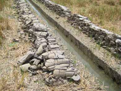
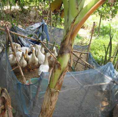
3 The Project Sustainable Management of Coastal Forest Ecosystems in Bac Lieu province : Funded by the German Ministry for the Environment Operative since May 2009 Main objectives: Coastal forest rehabilitation Biodiversity enhancement need for high resolution mapping of current species GTZ, Bac Lieu, Vietnam Page 3

4 Page 4

5 Track&Tracing biodiversity in Mangroves is challanging: most unfavourable environment for pen+paper recordings GIS-referencing only clusterwise possible information gathering only feasable with several people data digitilization always a potential source of error GTZ, Bac Lieu, Vietnam Page 5
 single")

6 Using rugged mobile phones for GISreferrenced biodiversity data gathering: water- and shock-resistant mobiles are always at hand and usually operational (fully charged) single spot entries are possible (no transsect clusters needed) one person can do the job recordet data can not be lost no additional data digitilization needed GTZ, Bac Lieu, Vietnam Page 6

7 GTZ, Bac Lieu, Vietnam Page 7
8 Satellite images: limited availability of updated high resolution images cloud covering very expensive just providing one layer of reference information (2 dimensional, no topography, no socioeconomic data, no hydrology etc...) GTZ, Bac Lieu, Vietnam Page 8


.")
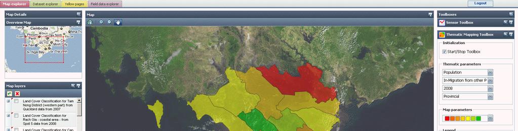
9 As GTZ-Bac Lieu we are piloting the introduction of mobile GIS-referenced biodiversity information gathering tailored software for data proofing and compilation open source available in Vietnamese WISDOM compartible different information layers available from WISDOM for generating analytical maps No extra purchase for updated own satellite images needed. No own additional research regarding cross-linking information needed (e.g. hydrology, topography, socio-economics etc). GTZ, Bac Lieu, Vietnam Page 9


10 WISDOM: Water Related Information System for the Sustainable Development of the Mekong Delta Vietnam: 86 Mio. Inhabitants Mekong: 4,500 km Basin: 800,000 km² Tibet, through China, border between Myanmar/Laos Thailand/ Laos, through Cambodia, into South Vietnam Delta: 70,000 km² Challenge: cross boundary issues, dam building in North, China not in MRC, etc Page 10

11 High Population Pressure in the Cities Challenge of Land Consumption, Infrastructure, Pollution Page 11


12 Houses in Suburban Areas along the Mekong Challenge of unsufficient Drinking Water Supply Page 12


13 Mekong Delta: Rice and Aquaculture Challenge of Over-Application of Fertilizer, Pesticides etc Page 13

14 Partners of the WISDOM Project German Partners Vietnamese Partners UNU- EHS ZEF Universität Karlsruhe (FH) - DLR - Uni Würzburg - UNU-EHS - ZEF - INRES - GFZ - IWK - Eomap - DHI SIWRR, VAST GIRS Sub-Niapp SISD CTU SRHMC VNU IDR 6 Mio budget, 60 scientists, 15+5 PHDs students All WISDOM PhDs over one year in Delta 1 CIM Position at MOST Slide Page 14

15 IWRM-adapted, Trans-Disciplinary Project Structure Results of Research: Water Quality, Pollution Basin characteristics EO based Monitoring Analyses of Legal System Water quantity, demand, reliability Climate Change and Vulnerability Analyses Mekong Information System Landuse Change Institutional Mapping Training, CB Social Change Every partner: sustainability concept: how will data / answers be generated, when project is over Ownership, Implementation!!! Page 15
16 The WISDOM Restaurant Components Menu Restaurant Ability Kitchen Availability Storage Delivery Page 16
17 The WISDOM Restaurant Ordering Menu The XY-Water- Level a la Wisdom, please One second Menu Sensor data Water level Pesticides Thematic maps Statistics Geographic data Yellow pages Page 17
18 The WISDOM Restaurant Order taking Page 18
19 The WISDOM Restaurant Ingredients gathering Fresh Water level measures for the mekong delta at position XY, please Page 19
20 The WISDOM Restaurant Cooking Page 20
21 The WISDOM Restaurant Delivery Page 21
22 The WISDOM Information System Prototype Components Data User, Web Application Data Entry Portal Information Processing Environment Database, Data Storage Web services Page 22


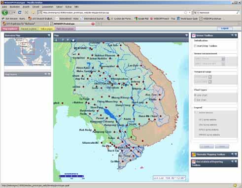
23 Prototype Entry Portal Page 23
24 Socio-Economic Data in the Information System Page 24


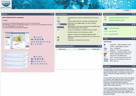
25 Impression of the Information System Prototype Page 25


26 Yellow Pages within the Information System Page 26
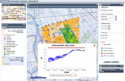
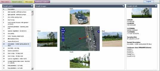
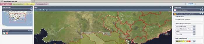
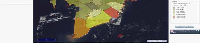
27 WISDOM Information System Prototype Page 27
28 Source: IPCC 2007 Sea Level Rise: Special Threat in Delta Areas Climate Change: Sea level rise will lead to: Delta flooding Increased coastal erosion Changed sedimentation Salinisation of water resources Salinisation of soils Ecosystem changes Expected migration of population Threats to industry Slide Page 28
29 National Water Ressources Strategy ( 2020, MONRE) Major Challenges identified by ADB (amongst many): The collection, management and archive of information on water and land resources are still dispersed. Data in different agencies is inconsistent and not exchanged among state agencies The monitoring, warning, and information systems for water quality, flood and drougt prediction,.. have not been properly developed Implementation measures (amongst many): Set up of general Land- and Water Information Systems, flood and drought monitoring systems, flash flood warning systems Slide Page 29
30 Main synergies from the cooperation (1): GTZ will have projects running in all coastal provinces and WISDOM covers Mekong Provinces since 3 years Different disciplinces complement each other value adding Data exchange, with low maintenance costs (Open Source) Data dissemination independent from location, soft- and hardware WISDOM provides neutral platform for data exchange data ownership can be ensured Joint standard allows easy map calibrations, valididations and comparability of results Page 30
31 Main synergies from the cooperation (2): More easy access for further RS data Bunch competences to approach threats of the Mekong Delta Increased efficiency for spatial and nonspatial data management Semantic enabled data identification Automatic integration of spatial data Easy extendable to other regions Page 31


32 Planned steps of cooperation: Applying the information system together Exchange of information, data, capacity building Introducing the WISDOM data standard for data originating from Coastal Management Projects Jointly developing and applying one method of landcover classification Page 32


33 Page 33
GEOMATICS. Shaping our world. A company of
 GEOMATICS Shaping our world A company of OUR EXPERTISE Geomatics Geomatics plays a mayor role in hydropower, land and water resources, urban development, transport & mobility, renewable energy, and infrastructure
Geographic Information Infrastructure and Policy Framework for Sustainable Mountain Development in the Hindu Kush-Himalayas
 Geo SMART ASIA 2017 22-24 August, Kualalampur Geographic Information Infrastructure and Policy Framework for Sustainable Mountain Development in the Hindu Kush-Himalayas Basanta Shrestha, Director Strategic
Remote sensing data uses and supply in Vietnam. Dr. Chu Hải Tùng National Remote Sensing Department, Ministry of Natural Resource and Environment
 Remote sensing data uses and supply in Vietnam Dr. Chu Hải Tùng National Remote Sensing Department, Ministry of Natural Resource and Environment Content Uses of remote sensing data in Vietnam Roles of
Building Institutional Capacity for Multi-Hazard Early Warning in Asia and the Pacific Subtitle
 Building Institutional Capacity for Multi-Hazard Early Warning in Asia and the Pacific Subtitle Title Keran Wang Chief, Space Applications Section ICT and Disaster Risk Reduction Division 22 May 2018 Pillar
DESIGN OF A MULTINATIONAL GIS-BASED INFORMATION MANAGEMENT SYSTEM FOR ENVIRONMENTAL DECISION MAKING IN THE MEKONG REGION
 DESIGN OF A MULTINATIONAL GIS-BASED INFORMATION MANAGEMENT SYSTEM FOR ENVIRONMENTAL DECISION MAKING IN THE MEKONG REGION Ian K Crain The Orbis Institute, Ottawa, Canada Crain@cyberus.ca Working Group KEY
Space Applications for Disaster Risk Reduction and Sustainable Development
 Space Applications for Disaster Risk Reduction and Sustainable Development Space Applications Section (SAS) ICT and Disaster Risk Reduction Division (IDD) UNESCAP Contents I. RESAP Activities 2016-2017
GIS Geographical Information Systems. GIS Management
 GIS Geographical Information Systems GIS Management Difficulties on establishing a GIS Funding GIS Determining Project Standards Data Gathering Map Development Recruiting GIS Professionals Educating Staff
12/05/2016. The First step in Adaptation to future climate change Reduce Vulnerability and Exposure to present Climate Variability (IPCC 2014)
") Integrating CCA, DRR and L+D to Address Emerging Challenges due to Slow Onset Processes Joy Jacqueline Pereira (Project Leader), SEADPRI-Universiti Kebangsaan Malaysia, Nguyen Van Thang (Collaborator),
Integrating CCA, DRR and L+D to Address Emerging Challenges due to Slow Onset Processes Joy Jacqueline Pereira (Project Leader), SEADPRI-Universiti Kebangsaan Malaysia, Nguyen Van Thang (Collaborator),
Study on Data Integration and Sharing Standard and Specification System for Earth System Science
 Study on Data Integration and Sharing Standard and Specification System for Earth System Science Juanle Wang and Jiulin Sun Information Sharing Center for Earth System Science Institute of Geographic Sciences
Megacity Research Project TP. Ho Chi Minh Adaptation to Global Climate Change in Vietnam: Integrative Urban and Environmental Planning Framework
 1. Organization 2. Global Warming 3. Starting Phase 4. Results, Transdisciplinarity, Low-Rise High Density 5. Risk of Flooding 6. Partners 7. Action Field 1 8. Action Field 2 9. Urban Development Trends
Georeferencing and Satellite Image Support: Lessons learned, Challenges and Opportunities
 Georeferencing and Satellite Image Support: Lessons learned, Challenges and Opportunities Shirish Ravan shirish.ravan@unoosa.org UN-SPIDER United Nations Office for Outer Space Affairs (UNOOSA) UN-SPIDER
State of Israel Ministry of Housing and Construction Survey of Israel. The Hydrological project case
 State of Israel Ministry of Housing and Construction Survey of Israel The Hydrological project case Survey of Israel Content Introduction To the Survey of Israel The operation assumptions The main responsibilities
EuroGEOSS Protected Areas Pilot
 EuroGEOSS Protected Areas Pilot Max Craglia European Commission Joint Research Centre Part 1: the present MyNatura2000 Mobile app. Awareness raising & volunteered data collection. Natura2000 covers 18%
Application of Satellite Data for Flood Forecasting and Early Warning in the Mekong River Basin in South-east Asia
 MEKONG RIVER COMMISSION Vientiane, Lao PDR Application of Satellite Data for Flood Forecasting and Early Warning in the Mekong River Basin in South-east Asia 4 th World Water Forum March 2006 Mexico City,
Harmonizing spatial databases and services at local and regional level
 Harmonizing spatial databases and services at local and regional level A. Ionita 1, M. Caian 2, V. Vassilev 3, V. Craciunescu 2, I. Nedelcu 4 1 Research Institute for Artificial Intelligence, Bucuresti,
Louis-François Guerre, Planet Action Coordinator Copenhagen, December Spot Image 2007
 Louis-François Guerre, Planet Action Coordinator Copenhagen, December 2009 1 Spot Image 2007 Spot Image, Earth Observation and geo-information services Satellite operator, imagery distributor SPOT4 SPOT5
GIS WHAT CAN GO WRONG?
 Page 1 of 11 GIS WHAT CAN GO WRONG? Christoph Feldkötter SMRP Hanoi, Vietnam, October 1999 FOREST COVER MONITORING PROJECT an MRC / GTZ project Initial Objective: To provide the MRC with basin-wide homogenous
Land Administration and Cadastre
 Geomatics play a major role in hydropower, land and water resources and other infrastructure projects. Lahmeyer International s (LI) worldwide projects require a wide range of approaches to the integration
CLIMATE RESILIENT ALTITUDINAL GRADIENTS (CRAGs)
") CLIMATE RESILIENT ALTITUDINAL GRADIENTS (CRAGs) BUILDING CLIMATE CHANGE RESILIENCE IN THE KIVU- RUSIZI WATERSHEDS Great Lake Conference Entebbe 2017 Chris Magero WHAT ARE CRAGs? Climate-Resilient Altitudinal
CLIMATE RESILIENT ALTITUDINAL GRADIENTS (CRAGs) BUILDING CLIMATE CHANGE RESILIENCE IN THE KIVU- RUSIZI WATERSHEDS Great Lake Conference Entebbe 2017 Chris Magero WHAT ARE CRAGs? Climate-Resilient Altitudinal
EO4SEE - THE PATHFINDER OF OPERATIONAL SATELLITE MONITORING FOR THE REGION OF THE BLACK SEA AND CENTRAL EUROPE
 EO4SEE: Pathfinder assessment for regional high volume data access, processing and information service delivery platforms - South East Region EO4SEE - THE PATHFINDER OF OPERATIONAL SATELLITE MONITORING
GIS as a tool in flood management
 GIS for the United Nations and the International Community Conference Panel: GIS and Capacity - How Territorial Planning Benefits from Geospatial Information 3-5 April 2012 Geneva, Switzerland GIS as a
Space Application in Support of Land Management for SDG Implementation
 Space Application in Support of Land Management for SDG Implementation Regional Expert Workshop on Land Accounting for SDG Monitoring and Reporting 26 September 2017 Space Application Section Information
AND THE COOPERATION WITH SENTINEL ASIA FOR DISASTER MANAGEMENT
 Ministry of Natural resources and Environment National Remote Sensing DEpartment NATIONAL REMOTE SENSING DEPARTMENT (NRSD) AND THE COOPERATION WITH SENTINEL ASIA FOR DISASTER MANAGEMENT By: Dr. Chu Hai
Current experiences in the use of satellite information in development aid activities
 Current experiences in the use of satellite information in development aid activities Meeting at ESA/ESRIN in Frascati 16 th of September 2017 #WorldInCommon AGENCE FRANÇAISE DE DÉVELOPPEMENT FRENCH DEVELOPMENT
ESCAP Promotes Geo-referenced Information System for Disaster Risk Management in Asia and the Pacific
 Third High Level Forum on UNGGIM 22-24 October 2014 Beijing, China ESCAP Promotes Geo-referenced Information System for Disaster Risk Management in Asia and the Pacific Keran Wang Space Applications Section,
Watershed Classification with GIS as an Instrument of Conflict Management in Tropical Highlands of the Lower Mekong Basin
 Page 1 of 8 Watershed Classification with GIS as an Instrument of Conflict Management in Tropical Highlands of the Lower Mekong Basin Project Abstract The University of Giessen is actually planning a research
RESAP Progress Report
 RESAP Progress Report December 2016 to October 2017 Presentation to the Twenty-first session of the Intergovernmental Consultative Committee on the Regional Space Applications Programme for Sustainable
Ⅴ.. Global Flood Alert System
 Ⅴ.. Global Flood Alert System 1. Project Concept - An attempt to make the best use of Satellite Rainfall in FEW - Support for existing FEW activities where necessary 2. Collaboration between: i) Space
MALDIVES. Regional Expert Workshop On Land Accounting For SDG Monitoring & Reporting (25-27 th Sept 2017) - Fathimath Shanna, Aishath Aniya -
 - Fathimath Shanna, Aishath Aniya -") MALDIVES Regional Expert Workshop On Land Accounting For SDG Monitoring & Reporting (25-27 th Sept 2017) - Fathimath Shanna, Aishath Aniya - ABOUT MALDIVES Approximately 860 km long and 120 km wide Consists
MALDIVES Regional Expert Workshop On Land Accounting For SDG Monitoring & Reporting (25-27 th Sept 2017) - Fathimath Shanna, Aishath Aniya - ABOUT MALDIVES Approximately 860 km long and 120 km wide Consists
Rainfall-River Forecasting: Overview of NOAA s Role, Responsibilities, and Services
 Dr. Thomas Graziano Chief Hydrologic Services Division NWS Headquarters Steve Buan Service Coordination Hydrologist NWS North Central River Forecast Center Rainfall-River Forecasting: Overview of NOAA
Open Data meets Big Data
 Open Data meets Big Data Max Craglia, Sven Schade, Anders Friis European Commission Joint Research Centre www.jrc.ec.europa.eu Serving society Stimulating innovation Supporting legislation JRC is Technical
PROJECT PORTFOLiO 1. PROJECT 2. REsEaRCh activities 3. CONTaCTs
 PROJECT PORTFOLiO Water-related Information System for the sustainable development of the Mekong Delta 1. PROJECT 2. REsEaRCh activities 3. CONTaCTs I 2011-2013 German Aerospace Center (DLR) Reproduction
RETA 6422: Mainstreaming Environment for Poverty Reduction Category 2 Subproject
 RETA 6422: Mainstreaming Environment for Poverty Reduction Category 2 Subproject A. Basic Data 1. Subproject Title: Poverty-Environment Mapping to Support Decision Making 2. Country Director: Adrian Ruthenberg
Future perspectives for EO in Development
 Future perspectives for EO in Development Meeting at ESA/ESRIN in Frascati 11 th of September 2018 #WorldInCommon AGENCE FRANÇAISE DE DÉVELOPPEMENT FRENCH DEVELOPMENT AGENCY 01. What is AFD? France s international
Voices from Private Sector: Insights for Future NSDI Development in Indonesia
 Voices from Private Sector: Insights for Future NSDI Development in Indonesia Ta n d a n g Yu l i a d i D w i P u t ra, Ryosuke S h i b a s a k i I n st i t u t e o f I n d u st r i a l S c i e n c e,
GIS and Remote Sensing
 Spring School Land use and the vulnerability of socio-ecosystems to climate change: remote sensing and modelling techniques GIS and Remote Sensing Katerina Tzavella Project Researcher PhD candidate Technology
GIS at UCAR. The evolution of NCAR s GIS Initiative. Olga Wilhelmi ESIG-NCAR Unidata Workshop 24 June, 2003
 GIS at UCAR The evolution of NCAR s GIS Initiative Olga Wilhelmi ESIG-NCAR Unidata Workshop 24 June, 2003 Why GIS? z z z z More questions about various climatological, meteorological, hydrological and
a national geological survey perspective François ROBIDA BRGM (French Geological Survey)
") a national geological survey perspective François ROBIDA BRGM (French Geological Survey) Pre-Conference Seminar on Socio-Economic Value of Geospatial for National and Regional Development 21 August 2017,
a national geological survey perspective François ROBIDA BRGM (French Geological Survey) Pre-Conference Seminar on Socio-Economic Value of Geospatial for National and Regional Development 21 August 2017,
Existing GIS Resources on the Indus Basin
 Existing GIS Resources on the Indus Basin Workshop on Spatial Information Analysis for the Sustainable Management of the Indus Basin in Pakistan May 26-27, 2003 Elements of Existing GIS Resources Data
Journey of supporting CSNs to establish Geo-DRM
 Regional Workshop on Geo-referenced Information Systems for Disaster Risk Management (Geo-DRM) 26-27 June 2014 Bangkok, Thailand Journey of supporting CSNs to establish Geo-DRM Keran Wang Chief, Space
World Meteorological Organization
 World Meteorological Organization Opportunities and Challenges for Development of Weather-based Insurance and Derivatives Markets in Developing Countries By Maryam Golnaraghi, Ph.D. Head of WMO Disaster
GIS in Weather and Society
 GIS in Weather and Society Olga Wilhelmi Institute for the Study of Society and Environment National Center for Atmospheric Research WAS*IS November 8, 2005 Boulder, Colorado Presentation Outline GIS basic
EUSAIR on sea topics from Slovenian perspective
 MINISTRY OF FOREIGN AFFAIRS REPUBLIC OF SLOVENIA EUSAIR on sea topics from Slovenian perspective Mag. Andreja Jerina National Coordinator 4 EU MRS: 270 millions of population 19 MS 12 non MS Sea basin
Report of the Working Group 2 Data Sharing and Integration for Disaster Management *
 UNITED NATIONS E/CONF.104/6 ECONOMIC AND SOCIAL COUNCIL Twentieth United Nations Regional Cartographic Conference for Asia and the Pacific Jeju, 6-9 October 2015 Item 5 of the provisional agenda Report
Use of geo-referenced data for DRM in Central Asia, problems and prospective
 Use of geo-referenced data for DRM in Central Asia, problems and prospective Dr. Akylbek Chymyrov Director, Kyrgyz Center of Geoinformation Systems Member of the Public Supervisory Board MES KR KSUCTA,
MANAGEMENT OF SPATIAL DATA IN MULTIDISCIPLINARY PROJECTS
 MANAGEMENT OF SPATIAL DATA IN MULTIDISCIPLINARY PROJECTS Ir. B.P.J. van den Bergh Resource Analysis Dr. Ir. A. de Vries IWACO BV Working Group IC-19, TC IV-3, WG IV/6 KEY WORDS: Spatial Data Management,
Els van Lavieren (Conservation International Suriname) Prof. Sieuwnath Naipal (Anton de Kom University, Suriname) 1
 Prof. Sieuwnath Naipal (Anton de Kom University, Suriname) 1") Building with Nature at Weg naar Zee, Paramaribo, Suriname A nature based solution for coastal resilience & mangrove restoration Ecological Mangrove Restoration Concept Els van Lavieren (Conservation International
Building with Nature at Weg naar Zee, Paramaribo, Suriname A nature based solution for coastal resilience & mangrove restoration Ecological Mangrove Restoration Concept Els van Lavieren (Conservation International
Regional Plan 4: Integrating Ecosystem Services Mapping into Regional Land Use Planning
 Rural-Urban Outlooks: Unlocking Synergies (ROBUST) ROBUST receives funding from the European Union s Horizon 2020 research and innovation programme under grant agreement No 727988.* October 2018 Natural
Building Institutional Capacity for Multi-Hazard Early Warning in Pacific Countries Subtitle
 Building Institutional Capacity for Multi-Hazard Early Warning in Pacific Countries Subtitle Title Keran Wang Chief, Space Applications Section ICT and Disaster Risk Reduction Division 30 March 2018 Slide
Extending the use of Flood Modeller Pro towards operational forecasting with Delft-FEWS
 Extending the use of Flood Modeller Pro towards operational forecasting with Delft-FEWS Simone van Schijndel, Department Head Operational Water Management and Early Warning Intentionally blank The world
Status after Six Years
 German-Indonesian Tsunami Early Warning System () Status after Six Years Joern Lauterjung and the -Team Challenge Indonesia Short Early Warning Time Tsunamis are generated at the trench (orange line) Traveltimes
GI Technology for Disaster Management
 GI Technology for Disaster Management 17 th ICC on the Regional Space Applications Programme for Sustainable Development (RESAP) 26 th Nov 2013 Bangkok Thailand Period and time of seasonal in thailand
Geospatial Information and Services for Disasters (GIS4D)
") Geospatial Information and Services for Disasters (GIS4D) 31 July 2017 Tae Hyung KIM ICT and Disaster Risk Reduction Division (IDD) UNESCAP 1 About ESCAP Who is ESCAP? United Nations Economic and Social
Geospatial Information and Services for Disasters (GIS4D) 31 July 2017 Tae Hyung KIM ICT and Disaster Risk Reduction Division (IDD) UNESCAP 1 About ESCAP Who is ESCAP? United Nations Economic and Social
INCA CE: Integrating Nowcasting with crisis management and risk prevention in a transnational framework
 INCA CE: Integrating Nowcasting with crisis management and risk prevention in a transnational framework Yong Wang ZAMG, Austria This project is implemented through the CENTRAL EUROPE Programme co-financed
Recent development of the National Hydro-Meteorological Service (NHMS) of Viet Nam for disaster risk reduction
 of Viet Nam for disaster risk reduction") Ministry of Natural Resources and Environment National Hydro-Meteorological Service Recent development of the National Hydro-Meteorological Service (NHMS) of Viet Nam for disaster risk reduction Tran Van
Ministry of Natural Resources and Environment National Hydro-Meteorological Service Recent development of the National Hydro-Meteorological Service (NHMS) of Viet Nam for disaster risk reduction Tran Van
GENERAL. CHAPTER 1 BACKGROUND AND PURPOSE OF THE GUIDELINES Background of the Guidelines Purpose of the Guidelines...
 GENERAL CHAPTER 1 BACKGROUND AND PURPOSE OF THE GUIDELINES... 1 1.1 Background of the Guidelines... 1 1.2 Purpose of the Guidelines... 3 CHAPTER 2 APPLICATION OF THE GUIDELINES... 3 2.1 Potential Users
Advancing Geoscientific Capability. Geological Survey of Finland
 Advancing Geoscientific Capability Geological Survey of Finland GTK in brief The Geological Survey of Finland (GTK) is one of the largest European centres of excellence in assessment, research and the
AS & A2 Geography for OCR. Tailored Courses. Slapton Ley
 AS & A2 Geography for OCR Tailored Courses Slapton Ley Please visit http://www.field-studies-council.org/outdoorclassroom/geography/aqa/ for alternative A-level AQA programmes OVERVIEW Since the assessment
CLIMATE CHANGE ADAPTATION BY MEANS OF PUBLIC PRIVATE PARTNERSHIP TO ESTABLISH EARLY WARNING SYSTEM
 CLIMATE CHANGE ADAPTATION BY MEANS OF PUBLIC PRIVATE PARTNERSHIP TO ESTABLISH EARLY WARNING SYSTEM By: Dr Mamadou Lamine BAH, National Director Direction Nationale de la Meteorologie (DNM), Guinea President,
DRRM in the Philippines: DRRM Projects, Geoportals and Socio-Economic Integration
 Regional workshop on Geo-referenced information system for improving disaster risk preparedness and management in Asia and the Pacific 26-27 June 2014, UNCC, Bangkok, Thailand DRRM in the Philippines:
I CAN DO sheets Southchurch High School
 Rate your confidence in the following topic content and geographical skills by ticking the appropriate column beside each point: Red = Not confident Yellow = Almost there Green = Confident Changing landscapes
GIS = Geographic Information Systems;
 What is GIS GIS = Geographic Information Systems; What Information are we talking about? Information about anything that has a place (e.g. locations of features, address of people) on Earth s surface,
CEOS Overview and JAXA Plans for Water Cycle Observation
 CEOS Overview and JAXA Plans for Water Cycle Observation Asian Water Cycle Symposium November 2-4, 2005 Tokyo, Japan Chu Ishida Japan Aerospace Exploration Agency (JAXA) Contents 1. CEOS overview 2. CEOS
INDONESIA S S UPDATE: GEOSPATIAL INFORMATION FOR SUSTAINABLE DEVELOPMENT RELATED TO INA SDI Dr. Asep Karsidi, M.Sc
 INDONESIA S S UPDATE: GEOSPATIAL INFORMATION FOR SUSTAINABLE DEVELOPMENT RELATED TO INA SDI Dr. Asep Karsidi, M.Sc GEOSPATIAL INFORMATION AGENCY 08 August, 2012 OUTLINE 1. Transformation Bakosurtanal into
EBA Engineering Consultants Ltd. Creating and Delivering Better Solutions
 EBA Engineering Consultants Ltd. Creating and Delivering Better Solutions ENHANCING THE CAPABILITY OF ECOSYSTEM MAPPING TO SUPPORT ADAPTIVE FOREST MANAGEMENT Prepared by: EBA ENGINEERING CONSULTANTS LTD.
Kyoto and Carbon Initiative - the Ramsar / Wetlands International perspective
 Kyoto and Carbon Initiative - the Ramsar / Wetlands International perspective (the thoughts of Max Finlayson, as interpreted by John Lowry) Broad Requirements Guideline(s) for delineating wetlands (specifically,
DEVELOPMENT AND APPLICATION OF HIGH- RESOLUTION GIS-BASED ATLAS TO ENHANCE WATERSHED MANAGEMENT IN THE PHILIPPINES
 DEVELOPMENT AND APPLICATION OF HIGH- RESOLUTION GIS-BASED ATLAS TO ENHANCE WATERSHED MANAGEMENT IN THE PHILIPPINES Nathaniel C. Bantayan Institute of Renewable Natural Resources College of Forestry and
Remote sensing of forest and land cover at the AUA GIS & Remote Sensing Lab
 AUA GIS AND REMOTE SENSING LAB An initiative of the AUA Acopian Center for the Environment and the AUA College of Science and Engineering http://ace.aua.am/gis-and-remote-sensing Remote sensing of forest
Development of a Regional Land Cover Monitoring System In the Lower Mekong Region a Joint Effort Between SERVIR-Mekong and Partners -
 Mekong Development of a Regional Land Cover Monitoring System In the Lower Mekong Region a Joint Effort Between SERVIR-Mekong and Partners - Aekkapol Aekakkararungroj SERVIR-Mekong Asian Disaster Preparedness
Chapter 1: Overview of Environment Statistics Characteristics and Challenges
 Chapter 1: Overview of Environment Statistics Characteristics and Challenges Workshop on Environment Statistics in support of the implementation of the Framework for the Development of Environment Statistics
Global Environment Facility - Integrating Watershed & Coastal Areas Management (GEF-IWCAM): Andros Demonstration Site
: Andros Demonstration Site") Global Environment Facility - Integrating Watershed & Coastal Areas Management (GEF-IWCAM): Andros Demonstration Site Coastal Aquifer Management in Small Island Developing States of the Caribbean: Challenges
Global Environment Facility - Integrating Watershed & Coastal Areas Management (GEF-IWCAM): Andros Demonstration Site Coastal Aquifer Management in Small Island Developing States of the Caribbean: Challenges
RISC-KIT: EWS-DSS Hotspot Tool
 RISC-KIT: EWS-DSS Hotspot Tool Robert McCall Ap van Dongeren Deltares www.risckit.eu This project has received funding from the European Union s Seventh Programme for Research, Technological Development
RiskCity Training package on the Application of GIS for multi- hazard risk assessment in an urban environment.
 RiskCity Training package on the Application of GIS for multi- hazard risk assessment in an urban environment. Cees van Westen (Westen@itc.nl) & Nanette C. Kingma (Kingma@itc.nl) ITC: Training & Research
Use of Geospatial data for disaster managements
 Use of Geospatial data for disaster managements Source: http://alertsystemsgroup.com Instructor : Professor Dr. Yuji Murayama Teaching Assistant : Manjula Ranagalage What is GIS? A powerful set of tools
Transboundary water management with Remote Sensing. Oluf Jessen DHI Head of Projects, Water Resources Technical overview
 Transboundary water management with Remote Sensing Oluf Jessen DHI Head of Projects, Water Resources Technical overview ozj@dhigroup.com Transboundary water management Water management across national
Current Status of Vietnam Coastal Erosion and Major Measures for Mitigation
 Vietnam Administration of Sea and Islands Center for Oceanography University of Transport and Communications Current Status of Vietnam Coastal Erosion and Major Measures for Mitigation Case Study: Thanh
Spatial Analysis of Natural Hazard and Climate Change Risks in Peri-Urban Expansion Areas of Dakar, Senegal
 1 Spatial Analysis of Natural Hazard and Climate Change Risks in Peri-Urban Expansion Areas of Dakar, Senegal URBAN WEEK 2009 BBL Preston Lounge Thursday, March 12, 2009 Christian Hoffmann GeoVille group
National Report on Weather Forecasting Service
 MINISTRY OF WATER RESOURCES AND METEOROLOGY DEPARTMENT OF METEOROLOGY, CAMBODIA National Report on Weather Forecasting Service Tokyo, 11-15 March 2014 Department of Meteorology, Cambodia Presentation Outline
Land Account : Indonesia
 Land Account : Indonesia Outline Environmental concerns Approach in compiling land account Results: Sumatera Land Account, Experimental Estimates Challenges Policy applications Further work Environmental
This table connects the content provided by Education Perfect to the NSW Syllabus.
 Education Perfect Geography provides teachers with a wide range of quality, engaging and innovative content to drive positive student learning outcomes. Designed by teachers and written by our in-house
A Spatial Decision Support System for Agriculture and Natural Resources Management in China
 9 th APGEOSS Symposium Xiangzheng Deng A Spatial Decision Support System for Agriculture and Natural Resources Management in China Need to take decisions and make critical day-to-day and long-term planning
Applying Hazard Maps to Urban Planning
 Applying Hazard Maps to Urban Planning September 10th, 2014 SAKAI Yuko Disaster Management Expert JICA Study Team for the Metro Cebu Roadmap Study on the Sustainable Urban Development 1 Contents 1. Outline
Global Challenges - Partnering with Service Providers. World Meteorological Organization. J. Lengoasa WMO Deputy Secretary-General
 WMO World Meteorological Organization Working together in weather, climate and water Global Challenges - Partnering with Service Providers J. Lengoasa WMO Deputy Secretary-General jlengoasa@wmo.int http://www.wmo.int/pages/gfcs/gfcs_en.html
CAN THO URBAN DEVELOPMENT AND RESILIENCE PROJECT
 CAN THO URBAN DEVELOPMENT AND RESILIENCE PROJECT 1 Phnom Penh Can Tho City HCM City EAST SEA 2 1 3 Highest Water Level WATER LEVEL RAISE IN CAN THO DURING LAST 40 YEARS 4 2 Land subsidence a threat that
Integration of Geo spatial and Statistical Information: The Nepelese Experience
 Integration of Geo spatial and Statistical Information: The Nepelese Experience Krishna Raj B.C. Joint Secretary Ministry of Land Reform and Management, Nepal 11 June, 2014 Presentation Outline The Country
Geospatial workflows and potential applications to the Sustainable Development Goals of countries in West Asia
 Geospatial workflows and potential applications to the Sustainable Development Goals of countries in West Asia Ameer Abdulla, PhD Senior Advisor, European Topic Center for Spatial Analysis, Spain Associate
National Disaster Management Centre (NDMC) Republic of Maldives. Location
 Republic of Maldives. Location") National Disaster Management Centre (NDMC) Republic of Maldives Location Country Profile 1,190 islands. 198 Inhabited Islands. Total land area 300 sq km Islands range b/w 0.2 5 sq km Population approx.
National Disaster Management Centre (NDMC) Republic of Maldives Location Country Profile 1,190 islands. 198 Inhabited Islands. Total land area 300 sq km Islands range b/w 0.2 5 sq km Population approx.
WMO/WWRP FDP: INCA CE
 WMO/WWRP FDP: INCA CE Yong Wang ZAMG, Austria This project is implemented through the CENTRAL EUROPE Programme co-financed by the ERDF INCA CE: implementation over Central Europe A Nowcasting Initiative
The Mekong Remote Sensing Initiative (MRSI) - Building Capacity through a Comprehensive Land Cover Change Analysis
 - Building Capacity through a Comprehensive Land Cover Change Analysis") International Symposium Sustaining Food Security and Managing Natural Resources in Southeast Asia - Challenges for the 21st Century - January 8-11, 2002 at Chiang Mai, Thailand The Mekong Remote Sensing
International Symposium Sustaining Food Security and Managing Natural Resources in Southeast Asia - Challenges for the 21st Century - January 8-11, 2002 at Chiang Mai, Thailand The Mekong Remote Sensing
National Hydro-Meteorological Service
 National Hydro-Meteorological Service IMPROVING INSTITUTIONAL NAL CAPACITY (IN CASE OF VIETNAM) Country Report for the first meeting of the RA-II (Asia) Working Group on Hydrological Forecasts and Assessments
Weather Climate Science to Service Partnership South Africa
 PROJECTS UNDERWAY Title of the Weather Climate Science to Service Partnership South Africa Together, building on an existing strong partnership, South African Weather Service and the Met Office will build
GIS Building Communities beyond National Borders (Building Successful Spatial Data Infrastructures) Nick Land, ESRI Europe
 Nick Land, ESRI Europe") GIS Building Communities beyond National Borders (Building Successful Spatial Data Infrastructures) Nick Land, ESRI Europe UK worst flooding in the last 60 years 350,000 households without drinking water
GIS Building Communities beyond National Borders (Building Successful Spatial Data Infrastructures) Nick Land, ESRI Europe UK worst flooding in the last 60 years 350,000 households without drinking water
Bistandsprosjekter i Sørøst-Asia
 Bistandsprosjekter i Sørøst-Asia -Sikre liv og verdier Lars R. Hole, Hanneke Luijting, Tor Ivar Mathisen og Kristine Gjesdal September 2017 Norwegian Meteorological Institute Background Ministry of Foreign
First Meeting of the Expert Group on Environment Statistics New York, March 2014
 First Meeting of the Expert Group on Environment Statistics New York, 26-28 March 2014 Experiences on the application of the new FDES Anand Sookun asookun@gmail.com Mauritius Contents Mauritius Old FDES
Vietnam Coastal Erosion - Cause and Challenges -
 Administration of Sea and Islands Center for Oceanography University of Transport and Communications, Hanoi Vietnam Vietnam Coastal Erosion - Cause and Challenges - Presenters: Pham Hoang KIEN Le Van CONG
Coastal Mapping Follow on? Bruno Frachon Corine Lochet Gaël Morvan
 Coastal Mapping Follow on? Bruno Frachon Corine Lochet Gaël Morvan Shared objectives; IHO DG MARE CPMR Development of a Joint European Coastal Mapping Programme (JECMaP) within the IHO EU network with
STATE GEOGRAPHIC INFORMATION DATABASE
 STATE GEOGRAPHIC INFORMATION DATABASE Data Information and Knowledge Management STATE GEOGRAPHIC INFORMATION DATABASE EXECUTIVE SUMMARY Utah has developed one of the most comprehensive statewide GIS resources
KENYA NATIONAL BUREAU OF STATISTICS Workshop on
 KENYA NATIONAL BUREAU OF STATISTICS Workshop on Capacity Building in Environment Statistics: the Framework for the Development of Environment Statistics (FDES 2013) Coordination with Sector Ministries
Eyes in the Sky & Data Analysis.
 Eyes in the Sky & Data Analysis How can we collect Information about Earth Climbing up Trees & Mountains Gathering Food Self Protection Understanding Surroundings By Travelling Collected Information Converted
MR. George ALEXAKIS, parallel session 3. "Mediterranean Sea Region. laying the conditions. for sustainable growth and jobs"
 parallel session 3 "Mediterranean Sea Region laying the conditions for sustainable growth and jobs" MR. George ALEXAKIS, elected Regional Councillor of Crete, Greece and representative of Crete in CRPM.