Remote sensing of forest and land cover at the AUA GIS & Remote Sensing Lab
|
|
|
- Linette Lesley Phelps
- 5 years ago
- Views:
Transcription

1 AUA GIS AND REMOTE SENSING LAB An initiative of the AUA Acopian Center for the Environment and the AUA College of Science and Engineering Remote sensing of forest and land cover at the AUA GIS & Remote Sensing Lab Stefan Schlaffer Aghavni Harutyunyan Sean Reynolds

2 About myself Flood probability M.Sc. in Environmental Sciences from University of Bayreuth, Germany Master s thesis in Soil Science on Tree Species Effects on N Mineralisation in Tropical Plantations Ph.D. in Geoinformation and Remote Sensing from Vienna University of Technology, Austria Use of SAR time series for flood and wetland mapping Microwave remote sensing at Vienna University of Technology, Austria Luxembourg Institute of Science and Technology 2
3 Use of SAR for wetland mapping Extraction of time series parameters, e.g. mean backscatter, annual amplitude, time of maximum backscatter Spatial representation of parameters, e.g. as RGB composite Jensen (2006) 4

4 Use of SAR for wetland mapping Extraction of time series parameters, e.g. mean backscatter, annual amplitude, time of maximum backscatter Spatial representation of parameters, e.g. as RGB composite Jensen (2006) 5

5 Use of SAR for wetland mapping Extraction of time series parameters, e.g. mean backscatter, annual amplitude, time of maximum backscatter Spatial representation of parameters, e.g. as RGB composite Subsequent classification and masking based on topographic data 6
6 American University of Armenia Since Feb. 2017: CIM integrated expert at AUA Position linked to the GIZ program Integrated Biodiversity Management in the South Caucasus (IBiS) Involved in the creation of the AUA GIS and Remote Sensing Lab Training of AUA colleagues and counterparts at ministries (e.g. Ministry of Emergency Situations, Ministry of Nature Protection) Building university partnerships with partners in Europe (e.g. Germany, Austria) and Armenia (YSU) 8
")


 Austrian")

7 Integrated Biodiversity Management, South Caucasus (IBiS) Overall Goal Promote better coordination of biodiversity and ecosystem services management across sectors on the basis of solid data. Clients: German Federal Ministry for Economic Cooperation and Development (BMZ) Austrian Development Cooperation (ADC) Duration: 12/ /2019 Volume (regional): 14,9 Mio. - thereof 5 Mio. ADC - additional BMZ funding foreseen
8 Topics addressed in IBiS Ecosystem Services Demonstrate and safeguard the various benefits people obtain from ecosystems, e.g. water supply, habitat for species, recreation & tourism, raw material, etc. Integrated Management of Biodiversity Bringing different sectors and stakeholders together for a common, sustainable and harmonized management of biodiversity. Mainstreaming Biodiversity Integrate the conservation and sustainable use of biodiversity into relevant sectoral or cross-sectoral programs and policies and raise the perception and awareness of people on the value of biodiversity.
 Sean Reynolds, M.Sc. in Geographic Information Systems, B.")

9 The AUA GIS & Remote Sensing Lab Aghavni Harutyunyan, M.Sc. and B.Sc. in Geography (Yerevan State University) Sean Reynolds, M.Sc. in Geographic Information Systems, B.Sc. in Anthropology (both Florida State University) Mapping in support of activities at the Acopian Center for the Environment, e.g. Ecotourism Effects of mining, tailings DRM Provides training in GIS and remote sensing to professionals at partner organizations 11
 and the")
10 GIS trainings Copyright: DRR Nat. Platform In July 2017, the Lab organized trainings for professionals from the Ministry of Emergency Situations (MES) and the Ministry of Nature Protection (MNP) Participants from Yerevan and different regions in Armenia 12

11 GIS trainings Copyright: DRR Nat. Platform Hoping to contribute to building a national network of GIS & remote sensing professionals in Armenia Participants from Yerevan and different regions in Armenia => aiming to build network of people with experience in GIS 13

12 Burned areas mapping Wildfires in Khosrov Forest Reserve and Artavan Mapping of affected areas using Landsat 8, Sentinel-2 and PlanetScope imagery Total affected area ca ha (according to S-2) Validation using high-res images (Worldview-3 provided by USFS) 14

13 Burned areas mapping Wildfires in Khosrov Forest Reserve and Artavan Mapping of affected areas using Landsat 8, Sentinel-2 and PlanetScope imagery Total affected area ca ha (according to S-2) Validation using high-res images (Worldview-3 provided by USFS) 15

14 Burned areas mapping Wildfires in Khosrov Forest Reserve and Artavan Mapping of affected areas using Landsat 8, Sentinel-2 and PlanetScope imagery Total affected area ca ha (according to S-2) Validation using high-res images (Worldview-3 provided by USFS) Updating of forest cover layers for Armenia (RF based on Landsat 8) 16
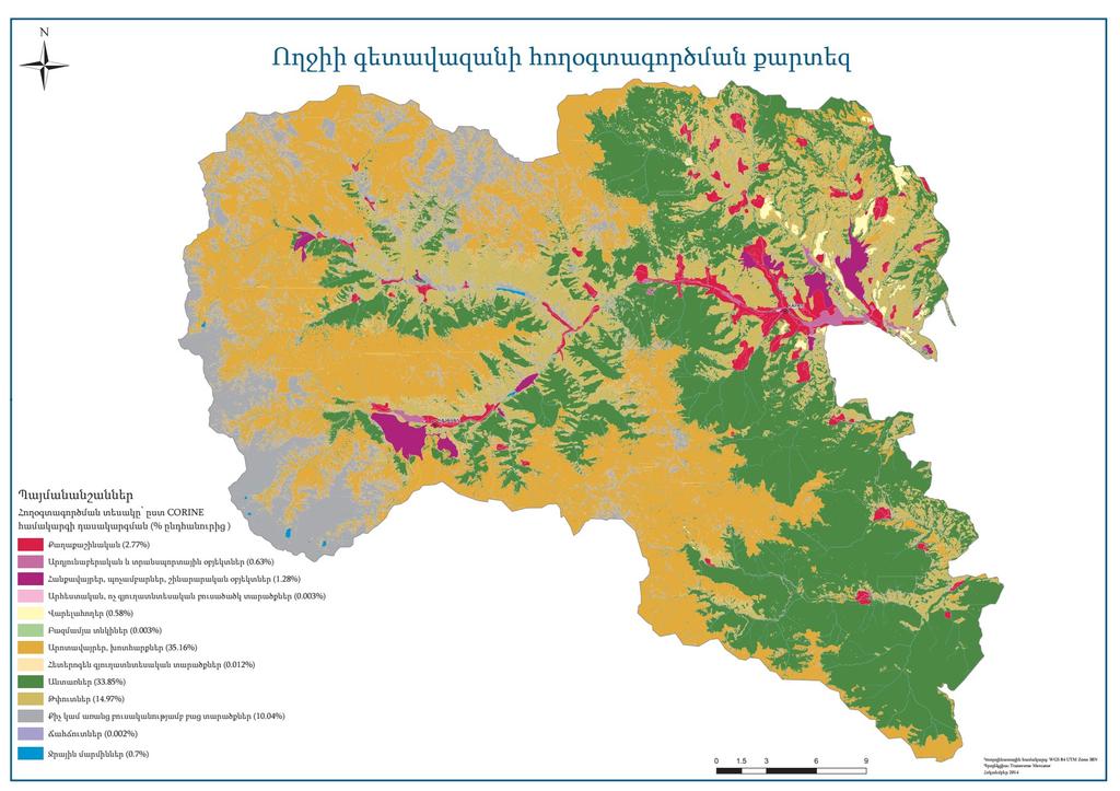
15 Land cover mapping in Syuniq Artak Piloyan (YSU) USAID Clean Energy & Water Program CORINE Level 2 land cover classification of Southern BMA Based on Rapideye imagery acquired in
16 Land cover mapping in Syuniq Artak Piloyan (YSU) USAID Clean Energy & Water Program Steps: Adaptation of CORINE system for Armenia Unsupervised Classification Field surveys for training supervised classification and validation Maximum Likelihood Classification 18
 USAID Clean Energy & Water Program Steps: Adaptation of CORINE system for Armenia Unsupervised Classification Field surveys for")
17 Land cover mapping in Syuniq Artak Piloyan (YSU) USAID Clean Energy & Water Program Steps: Adaptation of CORINE system for Armenia Unsupervised Classification Field surveys for training supervised classification and validation Maximum Likelihood Classification 19
18

19 Further activities Land cover mapping in Voghji River basin (funded by AUA research grant) focusing on changes (e.g. due to mining activities) Collaboration with State Forest Monitoring Center to strengthen capacities in forest monitoring using data from satellite and UAVs Building collaborations with universities in Armenia and Europe on topics, such as Monitoring of protected areas in Armenia Mapping of ecosystem services using Participatory GIS Assessment of hazards caused by tailings dam failure Organising regular lecture series on GIS & remote sensing 21
20 Conclusions and some lessons learned AUA as a link between different research groups Importance of High-quality basemap datasets Institutionalisation of knowledge Misconceptions about potential and limitations of GIS and Remote Sensing Minute-by-minute updates?? Plant species just one click away?? Promotion of Open Source software 22
 To be used for")

21 Drone DJI Phantom 3 Pro (quadcopter) To be used for DSMs of study areas, orthomosaics of forest areas, urban applications 23
22 AUA GIS AND REMOTE SENSING LAB An initiative of the AUA Acopian Center for the Environment and the AUA College of Science and Engineering Thank you!
Remote Sensing and EO activities at the University of Turku
 Remote Sensing and EO activities at the University of Turku Niina Käyhkö Associate Professor Department of Geography and Geology GEO meeting/syke May 23rd, 2018 Geospatial competence at the University
GEOMATICS. Shaping our world. A company of
 GEOMATICS Shaping our world A company of OUR EXPERTISE Geomatics Geomatics plays a mayor role in hydropower, land and water resources, urban development, transport & mobility, renewable energy, and infrastructure
SPLAN-Natura Towards an integrated spatial planning approach for Natura th January, 2017 Brussels. Commissioned by DG Environment
 SPLAN-Natura 2000 Towards an integrated spatial planning approach for Natura 2000 Commissioned by DG Environment 17 th January, 2017 Brussels V. Simeonova (Ph.D.) Drivers towards integrating Biodiversity
Use of geo-referenced data for DRM in Central Asia, problems and prospective
 Use of geo-referenced data for DRM in Central Asia, problems and prospective Dr. Akylbek Chymyrov Director, Kyrgyz Center of Geoinformation Systems Member of the Public Supervisory Board MES KR KSUCTA,
TOWARDS CLIMATE-RESILIENT COASTAL MANAGEMENT: OPPORTUNITIES FOR IMPROVED ICZM IN BELIZE
 TOWARDS CLIMATE-RESILIENT COASTAL MANAGEMENT: OPPORTUNITIES FOR IMPROVED ICZM IN BELIZE CHANTALLE SAMUELS Coastal Zone Management Authority and Institute The Caribbean Community Climate Change Centre VULNERABILITY
Integrated approaches to the implementation of the Convention on Biological Diversity
 Integrated approaches to the implementation of the Convention on Biological Diversity Actions on ABS in the context of UNESCO Biosphere Reserves Vibeke Jensen, Director UNESCO Liaison Office in New York
Spatial decision making in Armenia based on multidisciplinary environmental research
 EU FP7 EcoArm2ERA Integration into ERA Integration of spatial decision support systems and evidence based modeling in National/Regional Policy applications and regulatory systems: scientific and policy
The Governance of Land Use
 The planning system Levels of government and their responsibilities The Governance of Land Use COUNTRY FACT SHEET NORWAY Norway is a unitary state with three levels of government; the national level, 19
Land Administration and Cadastre
 Geomatics play a major role in hydropower, land and water resources and other infrastructure projects. Lahmeyer International s (LI) worldwide projects require a wide range of approaches to the integration
EUSAIR on sea topics from Slovenian perspective
 MINISTRY OF FOREIGN AFFAIRS REPUBLIC OF SLOVENIA EUSAIR on sea topics from Slovenian perspective Mag. Andreja Jerina National Coordinator 4 EU MRS: 270 millions of population 19 MS 12 non MS Sea basin
Concept note. High-Level Seminar: Accelerating Sustainable Energy for All in Landlocked Developing Countries through Innovative Partnerships
 Concept note High-Level Seminar: Accelerating Sustainable Energy for All in Landlocked Developing Countries through Innovative Partnerships Date: 24 and 25 October 2016 Venue: Conference Room C3, Vienna
SEISMIC RISK ASSESSMENT IN ARMENIA
 SEISMIC RISK ASSESSMENT IN ARMENIA Hovhannes Khangeldyan Head of National Crisis Management Center Rescue Service Ministry of Emergency Situations of the Republic of Armenia Tokyo, 2016 ARMENIA: GEOGRAPHICAL
Georeferencing and Satellite Image Support: Lessons learned, Challenges and Opportunities
 Georeferencing and Satellite Image Support: Lessons learned, Challenges and Opportunities Shirish Ravan shirish.ravan@unoosa.org UN-SPIDER United Nations Office for Outer Space Affairs (UNOOSA) UN-SPIDER
Leveraging Sentinel-1 time-series data for mapping agricultural land cover and land use in the tropics
 Leveraging Sentinel-1 time-series data for mapping agricultural land cover and land use in the tropics Caitlin Kontgis caitlin@descarteslabs.com @caitlinkontgis Descartes Labs Overview What is Descartes
16540/14 EE/cm 1 DG E 1A
 Council of the European Union Brussels, 5 December 2014 (OR. en) 16540/14 ENV 965 CULT 139 NOTE From: To: Subject: General Secretariat of the Council Delegations Charter of Rome on Natural and Cultural
Biodiversity and Protected Areas Management Project
 Biodiversity and Protected Areas Management Project Technical Advisor ESA region: Selwyn Willoughby Coordinator ESA region: Christine Mentzel FlexiCadastre EMEA Regional User Conference, Cape Town, South
EuroGEOSS Protected Areas Pilot
 EuroGEOSS Protected Areas Pilot Max Craglia European Commission Joint Research Centre Part 1: the present MyNatura2000 Mobile app. Awareness raising & volunteered data collection. Natura2000 covers 18%
Geospatial Information Management in the Americas: Lessons for the Post-2015 development agenda
 Geospatial Information Management in the Americas: Lessons for the Post-2015 development agenda Rolando Ocampo President, UN-GGIM: Americas October 2014 The integration of statistical and geographical
Spanish national plan for land observation: new collaborative production system in Europe
 ADVANCE UNEDITED VERSION UNITED NATIONS E/CONF.103/5/Add.1 Economic and Social Affairs 9 July 2013 Tenth United Nations Regional Cartographic Conference for the Americas New York, 19-23, August 2013 Item
Mapping Water Resources and Reservoirs for Climate Resilience in Zambezi River Basin
 Mapping Water Resources and Reservoirs for Climate Resilience in Zambezi River Basin Corné van der Sande, NEO BV Senior Advisor Earth Observation Services for Monitoring Drought and Water Resources in
Land Accounts - The Canadian Experience
 Land Accounts - The Canadian Experience Development of a Geospatial database to measure the effect of human activity on the environment Who is doing Land Accounts Statistics Canada (national) Component
DEPARTMENT OF GEOLOGY AND MINERAL INDUSTRIES WAYS & MEANS SUBCOMMITTEE ON NATURAL RESOURCES MARCH 2, 2017
 DEPARTMENT OF GEOLOGY AND MINERAL INDUSTRIES WAYS & MEANS SUBCOMMITTEE ON NATURAL RESOURCES MARCH 2, 2017 1 ABOUT DOGAMI AGENCY MISSION, VISION & GOALS 2 Lidar image of a stream network along the Umpqua
National Disaster Management Centre (NDMC) Republic of Maldives. Location
 Republic of Maldives. Location") National Disaster Management Centre (NDMC) Republic of Maldives Location Country Profile 1,190 islands. 198 Inhabited Islands. Total land area 300 sq km Islands range b/w 0.2 5 sq km Population approx.
National Disaster Management Centre (NDMC) Republic of Maldives Location Country Profile 1,190 islands. 198 Inhabited Islands. Total land area 300 sq km Islands range b/w 0.2 5 sq km Population approx.
USING HYPERSPECTRAL IMAGERY
 USING HYPERSPECTRAL IMAGERY AND LIDAR DATA TO DETECT PLANT INVASIONS 2016 ESRI CANADA SCHOLARSHIP APPLICATION CURTIS CHANCE M.SC. CANDIDATE FACULTY OF FORESTRY UNIVERSITY OF BRITISH COLUMBIA CURTIS.CHANCE@ALUMNI.UBC.CA
Observation (EO) & Geomatics in Canada
 & Geomatics in Canada") Innovating to Increase the Impact of Earth Observation (EO) & Geomatics in Canada Natural Resources Canada February 25, 2014 Prashant Shukle, Director General Canada Centre for Mapping and Earth Observation
Innovating to Increase the Impact of Earth Observation (EO) & Geomatics in Canada Natural Resources Canada February 25, 2014 Prashant Shukle, Director General Canada Centre for Mapping and Earth Observation
Rainforests and Deserts: Distribution, Uses, and Human Influences. Teacher s Masters California Education and the Environment Initiative
 E Teacher s Masters California Education and the Environment Initiative Earth Science Standard E.5.e. Rainforests and Deserts: Distribution, Uses, and Human Influences California Education and the Environment
XXIII CONGRESS OF ISPRS RESOLUTIONS
 XXIII CONGRESS OF ISPRS RESOLUTIONS General Resolutions Resolution 0: Thanks to the Czech Society commends: To congratulate The Czech Society, its president and the Congress Director Lena Halounová, the
Space Application in Support of Land Management for SDG Implementation
 Space Application in Support of Land Management for SDG Implementation Regional Expert Workshop on Land Accounting for SDG Monitoring and Reporting 26 September 2017 Space Application Section Information
Remote Sensing for Ecosystems
 MODULE GUIDE MSc ENR Remote Sensing for Ecosystems Semester 01 Modul coordinator Lecturers Michael Döring Pascal Ochsner, Diego Tonolla, Diane Whited, Michael Döring Martin Geilhausen Latest update August
COUNCIL OF THE EUROPEAN UNION. Brussels, 2 May /14 CULT 68
 COUNCIL OF THE EUROPEAN UNION Brussels, 2 May 2014 9129/14 CULT 68 NOTE from: General Secretariat of the Council to: Permanent Representatives Committee (Part 1) / Council No. prev. doc.: 8892/14 CULT
Excel Geomatics: Offering Excellence with Unique Consultancy & Services
 Excel Geomatics: Offering Excellence with Unique Consultancy & Services Providing consultancy and value Added Services using Remote Sensing, Photogrammetry and LiDAR in areas such as Agriculture, Forestry,
Establishing the National Spatial Data Infrastructure (NSDI) for Norway a joint effort by many stakeholders SPATIAL DATA FOR BENEFIT OF THE SOCIETY
 for Norway a joint effort by many stakeholders SPATIAL DATA FOR BENEFIT OF THE SOCIETY") Establishing the National Spatial Data Infrastructure (NSDI) for Norway a joint effort by many stakeholders SPATIAL DATA FOR THE BENEFIT OF SOCIETY OUTLINE Political background Norway digital - The Norwegian
Establishing the National Spatial Data Infrastructure (NSDI) for Norway a joint effort by many stakeholders SPATIAL DATA FOR THE BENEFIT OF SOCIETY OUTLINE Political background Norway digital - The Norwegian
Exploring GIS Potential for Northwestern Ontario Land Information Ontario
 Exploring GIS Potential for Northwestern Ontario Land Information Ontario May 13, 2015 The LIO Vision LIO Vision: That all geographic information about Ontario is fully integrated and accessible LIO Goal:
EAGLE Data Model and Outcomes of HELM (Harmonised European Land Monitoring)
") EAGLE Data Model and Outcomes of HELM (Harmonised European Land Monitoring) Contribution towards better land information harmonisation and INSPIRE compliance EAGLE working group Stephan Arnold, Barbara
EAGLE Data Model and Outcomes of HELM (Harmonised European Land Monitoring) Contribution towards better land information harmonisation and INSPIRE compliance EAGLE working group Stephan Arnold, Barbara
New Prospects for Peripheral Rural Regions Helmut Hiess Glasgow, 19th of May 2010
 New Prospects for Peripheral Rural Regions Helmut Hiess Glasgow, 19th of May 2010 ÖROK: Organisation & Tasks Austrian Conference on Spatial Planning (ÖROK, since 1971): Joint organisation by Federal level,
I&CLC2000 in support to new policy initiatives (INSPIRE, GMES,..)
") I&CLC2000 in support to new policy initiatives (INSPIRE, GMES,..) Manfred Grasserbauer, Director Joint Research Centre Institute for Environment and Sustainability 1 IMAGE 2000 European mosaic of satellite
I&CLC2000 in support to new policy initiatives (INSPIRE, GMES,..) Manfred Grasserbauer, Director Joint Research Centre Institute for Environment and Sustainability 1 IMAGE 2000 European mosaic of satellite
Space Applications for Disaster Risk Reduction and Sustainable Development
 Space Applications for Disaster Risk Reduction and Sustainable Development Space Applications Section (SAS) ICT and Disaster Risk Reduction Division (IDD) UNESCAP Contents I. RESAP Activities 2016-2017
Careers in downstream satellite applications. Michael Lawrence Business Development Director. Deimos Space UK
 Careers in downstream satellite applications Michael Lawrence Business Development Director Deimos Space UK 1 Agenda 1. What is the downstream sector? 2. What kinds of jobs are available? 3. What do you
Congratulations on the completion of your project that was supported by The Rufford Small Grants Foundation.
 The Rufford Small Grants Foundation Final Report Congratulations on the completion of your project that was supported by The Rufford Small Grants Foundation. We ask all grant recipients to complete a Final
WORLD DAY TO COMBAT DESERTIFICATION 2018 IN MONGOLIA
 WORLD DAY TO COMBAT DESERTIFICATION 2018 IN MONGOLIA This year the WDCD slogan was Land has true value. Invest in it to address the importance of sustainable land use, land degradation prevention and its
Bachelor of Geospatial Science The University of the South Pacific
 Bachelor of Geospatial Science The University of the South Pacific Geospatial Science Unit School of Geography, Earth Science and Environment Aleen Elisha Prasad Inesha Manzini Semisi Ketenilagi Geospatial
Compact guides GISCO. Geographic information system of the Commission
 Compact guides GISCO Geographic information system of the Commission What is GISCO? GISCO, the Geographic Information System of the COmmission, is a permanent service of Eurostat that fulfils the requirements
Extent. Level 1 and 2. October 2017
 Extent Level 1 and 2 October 2017 Overview: Extent account 1. Learning objectives 2. Review of Level 0 (5m) 3. Level 1 (Compilers): Concepts (15m) Group exercise and discussion (15m) 4. Level 2 (Data Providers)
ACTION PLAN FOR WORLD HERITAGE IN LATIN AMERICA AND THE CARIBBEAN ( )
") Annex ACTION PLAN FOR WORLD HERITAGE IN LATIN AMERICA AND THE CARIBBEAN (2014-2024) The current Regional Action Plan for Latin America and the Caribbean for 2014-2024 has been elaborated by the State Parties
Annex ACTION PLAN FOR WORLD HERITAGE IN LATIN AMERICA AND THE CARIBBEAN (2014-2024) The current Regional Action Plan for Latin America and the Caribbean for 2014-2024 has been elaborated by the State Parties
Virginia Shoreline Mapping Tools
 Virginia Shoreline Mapping Tools December 15, 2017 Karen Duhring Center for Coastal Resources Management Virginia Institute of Marine Science College of William & Mary Virginia Shoreline Mapping Tools
Challenges and Successes in Sharing Geospatial Data in Africa
 Challenges and Successes in Sharing Geospatial Data in Africa 2018 GeoNode Summit Torino, Italy March 26-28, 2018 Bernard Justus Muhwezi Manager, Geo-Information Services Uganda Bureau of Statistics, Kampala,
Margarita Stancheva Hristo Stanchev & Robert Young 2. MEDCOAST JUBILEE WORKSHOP May 2015, Iberotel Sarigerme Park, Dalaman, Turkey
 Margarita Stancheva Hristo Stanchev & Robert Young 2 INTRODUCTION: Bulgarian Black Sea coast INTRODUCTION: Increasing pressure on Bulgarian coastal zone In 2011, of the 7 364 570 people that lived in Bulgaria,
Journey of supporting CSNs to establish Geo-DRM
 Regional Workshop on Geo-referenced Information Systems for Disaster Risk Management (Geo-DRM) 26-27 June 2014 Bangkok, Thailand Journey of supporting CSNs to establish Geo-DRM Keran Wang Chief, Space
Object-Oriented Oriented Method to Classify the Land Use and Land Cover in San Antonio using ecognition Object-Oriented Oriented Image Analysis
 Object-Oriented Oriented Method to Classify the Land Use and Land Cover in San Antonio using ecognition Object-Oriented Oriented Image Analysis Jayar S. Griffith ES6973 Remote Sensing Image Processing
Land Use in the context of sustainable, smart and inclusive growth
 Land Use in the context of sustainable, smart and inclusive growth François Salgé Ministry of sustainable development France facilitator EUROGI vice president AFIGéO board member 1 Introduction e-content+
CircUse News Special: The CircUse Compendium. This project is implemented through the CENTRAL EUROPE Programme co-financed by the ERDF
 CircUse News 9 2013 Special: This project is implemented through the CENTRAL EUROPE Programme co-financed by the ERDF 2 Newly published: Figure 1: Students in Trnava working on brownfield revitalisation.
Empowered lives. Resilient nations. Data for People and Planet. powered by
 Empowered lives. Resilient nations. Data for People and Planet powered by Overview As we enter the fourth industrial revolution, technology is revolutionizing our ability to map nature. Satellite data
Mutah university faculty of Social Sciences The Study plan of the department of Geography 2006/2007
 Mutah university faculty of Social Sciences The Study plan of the department of Geography 2006/2007 Requirements university compulsory 22 Credit hours Course No Credit hours Prerequisite Requirements Faculty
Implementing the Sustainable Development Goals: The Role of Geospatial Technology and Innovation
 Fifth High Level Forum on UN Global Geospatial Information Management Implementing the Sustainable Development Goals: The Role of Geospatial Technology and Innovation 28-30 November 2017 Sheraton Maria
Current LCLUC challenges in SCERIN: Assessing Ecosystem Function and Processes
 Summary of the SCERIN 2 meeting Current LCLUC challenges in SCERIN: Assessing Ecosystem Function and Processes Katarzyna Ostapowicz Department of GIS, Cartography and Remote Sensing, Institute of Geography
Briefing. H.E. Mr. Gyan Chandra Acharya
 Briefing by H.E. Mr. Gyan Chandra Acharya Under-Secretary-General and High Representative for the Least Developed Countries, Landlocked Developing Countries and Small Island Developing States Briefing
Development of Geospatial Information in Indonesia: Progress & Challenge
 Development of Geospatial Information in Indonesia: Progress & Challenge Dr. Nurwadjedi Sarbini Deputy of Thematic Geospatial Information Geospatial Information Agency (BIG) Geosmart Asia, September 29
Call for Applications
 Call for Applications for a PanAfGeo Training «WP1 Geoscientific Mapping, part WP1E1 Remote Sensing» 20-30 November 2017, Bishoftu, Ethiopia in English 1. MAIN CONTEXT OF PANAFGEO PanAfGeo for Pan-African
Rural GIS Applications Geospatial Technology Awareness
 Rural GIS Applications Geospatial Technology Awareness Mike Rudibaugh, Ph.D. Co-PI NSF GeoTech Center Geography/GIS Instructor Lake Land College mrudibau@lakeland.cc.il.us 217-234-5244 What is the GeoTech
Fig 1. Steps in the EcoValue Project
 Assessing the Social and Economic Value of Ecosystem Services in the Northern Forest Region: A Geographic Information System (GIS) Approach to Landscape Valuation Principal Investigator(s): Dr. Matthew
Summary Description Municipality of Anchorage. Anchorage Coastal Resource Atlas Project
 Summary Description Municipality of Anchorage Anchorage Coastal Resource Atlas Project By: Thede Tobish, MOA Planner; and Charlie Barnwell, MOA GIS Manager Introduction Local governments often struggle
NCAVES - Global initiative and national pilots
 NCAVES - Global initiative and national pilots Kavita Sharma UN Environment Pretoria, March 2018 Outline 1. Global initiative > Introduction > Objectives and deliverables >Activities in 2017 and 2018 2.
Utilization of Global Map for Societal Benefit Areas
 Utilization of Global Map for Societal Benefit Areas The Fourth GEOSS AP Symposium Bali Indonesia, 11th March 2010 Shuhei Kojima Geographical Survey Institute Ministry of Land, Infrastructure, Transport
PROTOCOL ON THE IMPLEMENTATION OF THE ALPINE CONVENTION OF 1991 RELATING TO SPATIAL PLANNING AND SUSTAINABLE DEVELOPMENT
 PROTOCOL ON THE IMPLEMENTATION OF THE ALPINE CONVENTION OF 1991 RELATING TO SPATIAL PLANNING AND SUSTAINABLE DEVELOPMENT SPATIAL PLANNING AND SUSTAINABLE DEVELOPMENT" PROTOCOL Preamble The Republic of
WELCOME & INTRODUCTION
 MPA Management Capacity Building Training Module 1: WELCOME & INTRODUCTION Participants Distinguished Guests Welcome Site Overviews of MPAs represented Overview of Training Program What are Today s Objectives?
Land Use / Land Cover Mapping in
 Land Use / Land Cover Mapping in Eastern and Southern African Regions RCMRD Experience by 6/24/2013, Nairobi Kenya Dr. Tesfaye Korme Director of RS, GIS and Mapping, RCMRD I. About RCMRD, Its Vision and
CONFERENCE STATEMENT
 CONFERENCE STATEMENT We, the elected representatives from Canada, Denmark/Greenland, Finland, Iceland, Norway, Russia, Sweden and the United States of America; In collaboration with the indigenous peoples
Towards best practices for using satellite Earth Observation in mining and extractives
 Towards best practices for using satellite Earth Observation in mining and extractives EU-Latin America Mining & Exploration Convention and Trade Show METS 2018 11 April 2018 Madrid Marriott Auditorium
The Integrated Ge spatial Information Framework to the strengthening of NSDI, Mongolia
 Young Geospatial Professionals Summit 21 NOV 2018 The Integrated Ge spatial Information Framework to the strengthening of NSDI, Mongolia BAYARMAA ENKHTUR Geospatial information and technology department
GIS and Remote Sensing
 Spring School Land use and the vulnerability of socio-ecosystems to climate change: remote sensing and modelling techniques GIS and Remote Sensing Katerina Tzavella Project Researcher PhD candidate Technology
Green areas: numerous positive effects for sustainable metropolis Satellite images : an easy way to map vegetation
 Green areas: numerous positive effects for sustainable metropolis Satellite images : an easy way to map vegetation Copernicus Training and Information Session 10 and 11 may 2017 in Lund, Sweden Dominique
National Remote Sensing Center of China. Space Technology for Sustainable Development in China Status, Achievements and Futures.
 National Remote Sensing Center of China Space Technology for Sustainable Development in China Status, Achievements and Futures Jing Li National Remote Sensing Center of China Ministry of Science and Technology,
Better Topographic Map Production Using ArcGIS. A Comprehensive Solution for Mapping Organizations
 Better Topographic Map Production Using ArcGIS A Comprehensive Solution for Mapping Organizations The World Is Always Changing As a member of a national mapping organization, you know this is true. You
Natura 2000 and spatial planning. Executive summary
 Natura 2000 and spatial planning Executive summary DISCLAIMER The information and views set out in this study are those of the author(s) and do not necessarily reflect the official opinion of the Commission.
Applying GIS to Coastal Management in Cork Harbour: the Corepoint experience
 Applying GIS to Coastal Management in Cork Harbour: the Corepoint experience Kathrin Köpke University College Cork, Ireland Thematic Conference: THE WATERFRONT MANAGEMENT AND GI (IT), 14 th -18 th November
LAND COVER CATEGORY DEFINITION BY IMAGE INVARIANTS FOR AUTOMATED CLASSIFICATION
 LAND COVER CATEGORY DEFINITION BY IMAGE INVARIANTS FOR AUTOMATED CLASSIFICATION Nguyen Dinh Duong Environmental Remote Sensing Laboratory Institute of Geography Hoang Quoc Viet Rd., Cau Giay, Hanoi, Vietnam
RETA 6422: Mainstreaming Environment for Poverty Reduction Category 2 Subproject
 RETA 6422: Mainstreaming Environment for Poverty Reduction Category 2 Subproject A. Basic Data 1. Subproject Title: Poverty-Environment Mapping to Support Decision Making 2. Country Director: Adrian Ruthenberg
Adaptation to Climate Change in other Mountain Regions
 Adaptation to Climate Change in other Mountain Regions First Working Group of the Carpathian Convention on Adaptation to Climate Change Brussels, 4-5 February 2012 Pictures: A. Czaderna, A.& D. Nowak,
SDG s and the role of Earth Observation
 SDG s and the role of Earth Observation Christian Heipke IPI - Institute for Photogrammetry and GeoInformation Leibniz Universität Hannover Germany Secretary General, ISPRS 1. No Poverty 2. Zero Hunger
Non-Governmental Organizations for Spatial Data Infrastructure. Environmental Democracy Case
 Non-Governmental Organizations for Spatial Data Infrastructure Environmental Democracy Case L.Jovičić, S.Vrečar, V.Cetl, K.Ristovski GSDI Small Grant Program Award 2011-2012 Non-Governmental Organisations
Building Institutional Capacity for Multi-Hazard Early Warning in Asia and the Pacific Subtitle
 Building Institutional Capacity for Multi-Hazard Early Warning in Asia and the Pacific Subtitle Title Keran Wang Chief, Space Applications Section ICT and Disaster Risk Reduction Division 22 May 2018 Pillar
Working Paper. Remote Sensing of Land-Cover/Land-Use in the Voghji River Basin, Syunik Region, Armenia
 Working Paper Remote Sensing of Land-Cover/Land-Use in the Voghji River Basin, Syunik Region, Armenia Stefan Schlaffer 1,2 and Aghavni Harutyunyan 1,2 1 AUA Acopian Center for the Environment 2 AUA GIS
GIS as a tool in flood management
 GIS for the United Nations and the International Community Conference Panel: GIS and Capacity - How Territorial Planning Benefits from Geospatial Information 3-5 April 2012 Geneva, Switzerland GIS as a
World Meteorological Organization
 World Meteorological Organization Opportunities and Challenges for Development of Weather-based Insurance and Derivatives Markets in Developing Countries By Maryam Golnaraghi, Ph.D. Head of WMO Disaster
Geospatial technology for land cover analysis
 Home Articles Application Environment & Climate Conservation & monitoring Published in : Middle East & Africa Geospatial Digest November 2013 Lemenkova Polina Charles University in Prague, Faculty of Science,
This table connects the content provided by Education Perfect to the NSW Syllabus.
 Education Perfect Geography provides teachers with a wide range of quality, engaging and innovative content to drive positive student learning outcomes. Designed by teachers and written by our in-house
National Survey on the Natural Environment of Japan. Hajime Hirosawa Biodiversity Center of Japan Ministry of the Environment (MOE)
") National Survey on the Natural Environment of Japan Hajime Hirosawa Biodiversity Center of Japan Ministry of the Environment (MOE) Biodiversity Center of Japan, MOE Establishment: 1998 Purpose: to encourage
National Survey on the Natural Environment of Japan Hajime Hirosawa Biodiversity Center of Japan Ministry of the Environment (MOE) Biodiversity Center of Japan, MOE Establishment: 1998 Purpose: to encourage
STEREO ANALYST FOR ERDAS IMAGINE Stereo Feature Collection for the GIS Professional
 STEREO ANALYST FOR ERDAS IMAGINE Stereo Feature Collection for the GIS Professional STEREO ANALYST FOR ERDAS IMAGINE Has Your GIS Gone Flat? Hexagon Geospatial takes three-dimensional geographic imaging
Background and History
 p1 Background and History What is the Indian Ocean Climate Initiative? The Indian Ocean Climate Initiative (IOCI) is a strategic program of research and information transfer to support government decision-making.
The Role of EO Consultants and SMEs within GMES. Geoff Smith
 The Role of EO Consultants and SMEs within GMES Geoff Smith Enable clients to deliver useful, accurate and reliable environmental information from EO. Positioned to bridge the gaps between technology development,
Plenary Session 2, part 2 A European shared information system
 3 rd GMES Forum 5 6 June 2003 Athens Plenary Session 2, part 2 A European shared information system Gordon McInnes Deputy Director European Environment Agency 1 I keep six honest serving men. They taught
The Role of Urban Planning and Local SDI Development in a Spatially Enabled Government. Faisal Qureishi
 The Role of Urban Planning and Local SDI Development in a Spatially Enabled Government Faisal Qureishi 1 Introduction A continuous increase in world population combined with limited resources has lead
Data sources and classification for ecosystem accounting g
 Data sources and classification for ecosystem accounting Ken Bagstad 23 February 2015 Wealth Accounting and the Valuation of Ecosystem Services www.wavespartnership.org Data sources and classification
Towards Reliable Spatial Database of Informal Areas in Greater Cairo Region
 KEYWORDS informal areas, unreliable spatial data, spatial data collecting, capacity building SUMMARY The uncontrolled and rapid increase of Egypt s cities is a major problem of the country. More than the
Factors that Shape Places (Blacktown) Stage 3 Geography
 Stage 3 Geography") Factors that Shape Places (Blacktown) Stage 3 Geography Summary This unit is written for Stage 3 "Factors that shape places". It is a Geographical Inquiry, enabling students to work through the 3 stages
Factors that Shape Places (Blacktown) Stage 3 Geography Summary This unit is written for Stage 3 "Factors that shape places". It is a Geographical Inquiry, enabling students to work through the 3 stages
West-Estonian Archipelago Biosphere Reserve and Lima Action Plan
 West-Estonian Archipelago Biosphere Reserve and Lima Action Plan Lia Rosenberg, BR co ordinaator Toomas Kokovkin, MAB Focal Point ESTONIA 15.03.2016 LIMA Location on the globe and Europe The West-Estonian
Monitoring Land Cover and Land Use in Central Asia Remote Sensing Contributions from selected German projects
 Monitoring Land Cover and Land Use in Central Asia Remote Sensing Contributions from selected German projects NASA LCLUC Meeting, Tashkent, 11.-13.11.2013 Christopher Conrad University of Würzburg, Institute
Framework on reducing diffuse pollution from agriculture perspectives from catchment managers
 Framework on reducing diffuse pollution from agriculture perspectives from catchment managers Photo: River Eden catchment, Sim Reaney, Durham University Introduction This framework has arisen from a series
Arctic ecosystem services: TEEB Arctic Scoping study. Alexander Shestakov WWF Global Arctic Programme 3 December Arctic Biodiversity Congress
 Arctic ecosystem services: TEEB Arctic Scoping study Alexander Shestakov WWF Global Arctic Programme 3 December 20143 Arctic Biodiversity Congress Content 1. Project design 2. Approach 3. Challenges and
Edexcel GCSE Geography A
 Edexcel GCSE Comparing the 2012 AQA GCSE specification with the new 2016 Edexcel specification This document is designed to help you compare the existing 2012 AQA GCSE specification (9030) with the new