GIS & E-Marketing. Presented by: Dr. Mark R. Leipnik & Dr. Sanjay Mehta Dept. of Geography & Dept. of Marketing Sam Houston State University
|
|
|
- Bonnie Morgan
- 5 years ago
- Views:
Transcription

1 GIS & E-Marketing Presented by: Dr. Mark R. Leipnik & Dr. Sanjay Mehta Dept. of Geography & Dept. of Marketing Sam Houston State University

2 Presentation is based on a chapter in the fourth-coming book: Advances in Electronic-Marketing, T. Flaherty, Ed. The field involves growing and synergistic interaction between technologies; like GIS, the Internet, and increasingly wireless communication, mobile computing and GPS & various marketing channels, modalities & methods ; including B to C, B to B, and market research.
3 Myriad B to C Applications:! Interactive-mapping as a component of web sites promoting/selling goods & services.! Accessing geospatial data on the internet as a component of sales presentations.! Serving or updating maps & directions on mobile devices (PDA, WI/FI, GPS, etc). Recently: Geographically pertinent search responses from search engines like Google.
4 Two Exemplary Applications: I will discuss examples of leading sites from two applicatio 1. Tourism. 2. Real-Estate. Each area has B to C, B to B and market research applications, but I will focus on interactive web-based mapping as a method to reach and influence consumers. These are ideal areas because spatial factors are critical, costs are substantial and vary widely and info needed for decisions is hard to obtain and involves multiple facets. Both the GIS and the Internet are critical & synergistic, Since users want maps but do not have their own GIS.
5 Effective Market Research Applications: eb-based access to interactive maps. Web-based access to geospatial data. Web-based services such as geo-coding customer addresses/zip code information. Web-based data sales (GDT, Claritas, ESRI). Mapping/analysis of web-site visitor IP address locale. Internet-based update of customer/service locations.
6 Tourism Site: Virtual Malaysia

7 An early on-line travel map

8

9

10

11

12

13 Identify a hotel and contact info and in most cases hot links are provided.

14

15

16

17

18

19

20

21

22

23

24

25 Malaysian GIS data is available for down-load on a linked site for use by mobile devices fitted with GPS for use by travelers.

26
27 Real-Estate Site: Realtor.Com

28 Maps of available property like this one have been an integral part of real estate marketing for over 150 years.

29
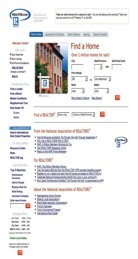
30 *

31

32 S.B. County in Southern California on this map"

33 Click on Southern California Region & zoom to it & SBC is gone.

34 Many design and content problems with maps on this site. The Intermediate scale maps mostly did not exist before site was built, so developers are doing a poor job putting them together for first time.

35 More detailed county level map, also has numerous flaws: Cartographic exaggeration makes Gaviota (Pop. ~ 100) appear to be the same size as Goleta (Pop. ~87,000).

36

37 Search for listings in Santa Barbara with criteria under $500,000 yielded only 30 properties. I selected the least expensive and then hit map it, site rapidly responded with this map.

38 Lowest priced listing in Santa Barbara: a 12 foot wide storage shed.

39 Priced to sell at only $50,000. Of course at that low price the contents are not included and most of the meager property is in the 25 year flood zone, I think.


40 One of the lowest priced actual homes, a $420,000, on 1/8 acre near the railroad tracks, But it can be mapped on Realtor.com site.

41 Highest priced home in Huntsville, Texas. A new on 11 acres for $395,000. It cannot be mapped on Realtor.com site. Many rural and newer properties cannot be mapped, since addresses do not match enhanced TIGER address data.
42 Ongoing Issues:! Bandwidth inadequacy: magnitude of data and number of functions on many sites causes glacial access times, frequent unavailability.! Content completeness: trade-off between ease of access & extent of data, & range of functions. Most effective sites often have a narrower focus.!cartography 101: Poor cartographic design of intermediate scale maps. Are web-techies in Mangalore doing the map design and compilation?! Dull Tools: Limited range of analysis tools on most sites. Radial search, identify, distance measurement, shortest path & time all exist, zoom and pan & search can do with improvement on most sites. But which functions are most necessary given user needs?
43 Conclusion: GIS & the Internet are mature technologies, both have numerous applications in marketing. The combination of these powerful technologies is a recent development. This nexus is continuing to evolve in interesting, awkward and hopefully profitable ways. Synergy between GIS & the Web are exemplified by international tourism and real-estate applications. Valuable lessons about limitations and opportunities can be learned examination of these application areas.
44 Myriad B to C Applications:! Interactive-mapping as a component of web sites promoting/selling goods & services.! Accessing geospatial data on the internet as a component of sales presentations.! Serving or updating maps & directions on mobile devices (PDA, WI/FI, GPS, etc). Recently: Geographically pertinent search responses from search engines like Google.
45 Evolving B to B Applications:! Determination of closest available suppliers of bulky, heavy, dangerous or highly specialized products.! Use of Internet-based mapping and GPS to tract widely distributed/mobile equipment for clients.! Serving data on available industrial sites & amenities for economic development/redevelopment. Frequently involves higher level spatial analysis (users are more sophisticated and committed than consumers).
46 Effective Market Research Applications: eb-based access to interactive maps. Web-based access to geospatial data. Web-based services such as geo-coding customer addresses/zip code information. Web-based data sales (GDT, Claritas, ESRI). Mapping/analysis of web-site visitor IP address locale. Internet-based update of customer/service locations.
Building a National Data Repository
 Building a National Data Repository Mladen Stojic, Vice President - Geospatial 1/30/2013 2012 Intergraph Corporation 1 Information has meaning and gives power only when shared and distributed. Information,
Write a report (6-7 pages, double space) on some examples of Internet Applications. You can choose only ONE of the following application areas:
 on some examples of Internet Applications. You can choose only ONE of the following application areas:") UPR 6905 Internet GIS Homework 1 Yong Hong Guo September 9, 2008 Write a report (6-7 pages, double space) on some examples of Internet Applications. You can choose only ONE of the following application
UPR 6905 Internet GIS Homework 1 Yong Hong Guo September 9, 2008 Write a report (6-7 pages, double space) on some examples of Internet Applications. You can choose only ONE of the following application
Putting the U.S. Geospatial Services Industry On the Map
 Putting the U.S. Geospatial Services Industry On the Map December 2012 Definition of geospatial services and the focus of this economic study Geospatial services Geospatial services industry Allow consumers,
Google Maps and Beyond
 Google Maps and Beyond Aaron Paul First American Title apaul@firstam.com 2015 APRA Symposium Association of Professional Reserve Analysts May 2 nd, 2015 Google Maps and Beyond - Overview Business case
What is Human Geography? HUMAN GEOGRAPHY. Human Geography. Human Geography 5/18/2015. Example of Differences: Hurricane Katrina
 What is Human Geography? Geography is the science of place and space. Geographers ask: Where are things located? Why things are located where they are? How places differ from one another? How people interact
file://q:\report1\greenatlasfinalreportindex.html
 Page 1 of 8 Quick Links WATER MANAGEMENT INTERNSHIP USDA HIS GRANT FUNDED FINAL PROJECT REPORT SUBMITTED BY MELISSA QUINTANA 11/07/07-03/24/08 Summary Provided is an assessment of my accomplishments for
Enhance Security, Safety and Efficiency With Geospatial Visualization
 Areas within 10 minutes of an exit are emphasized on this map, to give an indication of how accessible neighborhoods are by highway. The colors represent 1, 3, 5 and 10 minute increments from the exits.
Oakland County Parks and Recreation GIS Implementation Plan
 Oakland County Parks and Recreation GIS Implementation Plan TABLE OF CONTENTS 1.0 Introduction... 3 1.1 What is GIS? 1.2 Purpose 1.3 Background 2.0 Software... 4 2.1 ArcGIS Desktop 2.2 ArcGIS Explorer
Cartographic and Geospatial Futures
 Cartographic and Geospatial Futures 1. Web Cartography, WebGIS, & Virtual Globes--New Roles for Maps, GIS, and GIS professionals 2. Map Mashups, the Neo Neo-geography Movement, & Crowd-sourcing Geospatial
When Map Quality Matters
 When Map Quality Matters 50% 25% Powerful geospatial mapping tools for Adobe Creative Cloud and offline map solutions for mobile devices 20% When Map Quality Matters 10% We re focused on creating powerful
What is GIS? G: Geographic, Geospatial, Geo
 GEOG 488/588: GIS I Introduction Instructor: Geoffrey Duh TA: David Graves What is GIS? G: Geographic, Geospatial, Geo Alternatives: Spatial Information Systems, Land Information Systems Geography diverse
Geo Business Gis In The Digital Organization
 We have made it easy for you to find a PDF Ebooks without any digging. And by having access to our ebooks online or by storing it on your computer, you have convenient answers with geo business gis in
Sharing GIS to Empower the End User David Wray, Roanoke County, Virginia
 Sharing GIS to Empower the End User David Wray, Roanoke County, Virginia Sharing GIS to Empower the End User Roanoke County, Virginia Roanoke County, Virginia Population: 92,901 Area: 251 Square Miles
Map Services Are We Getting It?
 Map Services Are We Getting It? Rich Herrmann VP Global Platforms & Technology, IHS James Sanders Senior Product Manager, IHS April 19, 2011 Houston, TX USA Overview The Challenge Keith Fraley s 2010 PUG
The Emerging Role of Enterprise GIS in State Forest Agencies
 The Emerging Role of Enterprise GIS in State Forest Agencies Geographic Information System (GIS) A geographic information system (GIS) is a computer software system designed to capture, store, manipulate,
Geo-identification and pedestrian navigation with geo-mobile applications: how do users proceed?
 TU Vienna presentation 17 th July 2008 Geo-identification and pedestrian navigation with geo-mobile applications: how do users proceed? Ioannis Delikostidis Corné van Elzakker INTERNATIONAL INSTITUTE FOR
United States Forest Service Makes Use of Avenza PDF Maps App to Reduce Critical Time Delays and Increase Response Time During Natural Disasters
 CASE STUDY For more information, please contact: Christine Simmons LFPR Public Relations www.lfpr.com (for Avenza) 949.502-7750 ext. 270 Christines@lf-pr.com United States Forest Service Makes Use of Avenza
CHARTING SPATIAL BUSINESS TRANSFORMATION
 CHARTING SPATIAL BUSINESS TRANSFORMATION An in-depth look at the business patterns of GIS and location intelligence adoption in the private sector EXECUTIVE SUMMARY The global use of geographic information
STATE GEOGRAPHIC INFORMATION DATABASE
 STATE GEOGRAPHIC INFORMATION DATABASE Data Information and Knowledge Management STATE GEOGRAPHIC INFORMATION DATABASE EXECUTIVE SUMMARY Utah has developed one of the most comprehensive statewide GIS resources
Geo-enabling a Transactional Real Estate Management System A case study from the Minnesota Dept. of Transportation
 Geo-enabling a Transactional Real Estate Management System A case study from the Minnesota Dept. of Transportation Michael Terner Executive Vice President Co-author and Project Manager Andy Buck Overview
Your web browser (Safari 7) is out of date. For more security, comfort and. the best experience on this site: Update your browser Ignore
 is out of date. For more security, comfort and. the best experience on this site: Update your browser Ignore") Your web browser (Safari 7) is out of date. For more security, comfort and Activityengage the best experience on this site: Update your browser Ignore Introduction to GIS What is a geographic information
Your web browser (Safari 7) is out of date. For more security, comfort and Activityengage the best experience on this site: Update your browser Ignore Introduction to GIS What is a geographic information
Purpose Study conducted to determine the needs of the health care workforce related to GIS use, incorporation and training.
 GIS and Health Care: Educational Needs Assessment Cindy Gotz, MPH, CHES Janice Frates, Ph.D. Suzanne Wechsler, Ph.D. Departments of Health Care Administration & Geography California State University Long
Indicator: Proportion of the rural population who live within 2 km of an all-season road
 Goal: 9 Build resilient infrastructure, promote inclusive and sustainable industrialization and foster innovation Target: 9.1 Develop quality, reliable, sustainable and resilient infrastructure, including
Rural Louisiana. A quarterly publication of the Louisiana Tech Rural Development Center
 Rural Louisiana A quarterly publication of the Louisiana Tech Rural Development Center Volume 4, No. 1, Fall 2009 Editor: Aaron K. Lusby Director, Asst. Professor Newsletter design: Stephanie Tidwell Student
GIS Capability Maturity Assessment: How is Your Organization Doing?
 GIS Capability Maturity Assessment: How is Your Organization Doing? Presented by: Bill Johnstone Principal Consultant Spatial Vision Group November 8, 2018 1. Motivation for Capability Maturity Models
Key Questions and Issues. What is GIS? GIS is to geographic analysis as: What is GIS? 9/3/2013. GEO 327G/386G, UT Austin 1
 What is GIS? Key Questions and Issues Geology Elevation Transportation Hydrography Imagery What is GIS? What are the applications of GIS? How is the real world represented in GIS? What analyses can GIS
SoilView: Development of a Custom GIS Application for Publishing Soil Surveys
 SoilView: Development of a Custom GIS Application for Publishing Soil Surveys Allan Johnson and Mike Wigginton Abstract Currently, digital soils information can be obtained from many sources. Numerous
ESRI Delivering geographic information systems to millions of users
 Using Web GIS to Track Government Spending and Performance Eric Floss - ESRI April 12, 2010 ESRI Delivering geographic information systems to millions of users GIS Is Changing Everything How We Reason
IAA CAT RESPONSE HURRICANE HARVEY. Sealy CAT Yard
 IAA CAT RESPONSE HURRICANE HARVEY Sealy CAT Yard 17,600+ KAR Team Members EVERY CATASTROPHE IS DIFFERENT Every catastrophe is different. Timing, intensity, landfall location and population are just a few
BROADBAND DEMAND AGGREGATION: PLANNING BROADBAND IN RURAL NORTHERN CALIFORNIA
 BROADBAND DEMAND AGGREGATION: PLANNING BROADBAND IN RURAL NORTHERN CALIFORNIA Steven J. Steinberg, Ph.D a,b, *, Rebecca Degagne a, M.S., Michael Gough a a Institute for Spatial Analysis, Humboldt State
Welcome to GST 101: Introduction to Geospatial Technology. This course will introduce you to Geographic Information Systems (GIS), cartography,
, cartography,") Welcome to GST 101: Introduction to Geospatial Technology. This course will introduce you to Geographic Information Systems (GIS), cartography, remote sensing, and spatial analysis through a series of
Welcome to GST 101: Introduction to Geospatial Technology. This course will introduce you to Geographic Information Systems (GIS), cartography, remote sensing, and spatial analysis through a series of
State-of-the-Art GIS as an Integrating Technology
 Paper # 104: GIS for Oil Spill Prevention & Response Devon Humphrey Instructor, National Spill Control School Texas A&M University at Corpus Christi, TX Introduction and History The National Spill Control
for an Informed Analysis of A Socio-Economic Perspective Adrijana Car, Marike Bontenbal and Marius Herrmann
 Creating a GIS-Base for an Informed Analysis of Tourism Development: A Socio-Economic Perspective Adrijana Car, Marike Bontenbal and Marius Herrmann adrijana.car@gutech.edu.om edu GSS 2012 Affiliated to:
Using ArcGIS Server to Bring Geospatial Analysis
 Using ArcGIS Server to Bring Geospatial Analysis and Mapping to non-gis Analysts ESRI Health User Conference September 22, 2009 Jim Laramie, Altarum Institute Sam Wang, Altarum Institute Agenda Agenda
IH 35 at Blanco River May 2015
 IH 35 at Blanco River May 2015 Presentation Objectives Background of historical damage assessment processes Introduction to Collector App ( Mat Peck) Collector App and Flood Damage Assessment (Katie Steele)
USING TECHNOLOGY TO SHARE GIS David Wray, Roanoke County, Virginia
 USING TECHNOLOGY TO SHARE GIS David Wray, Roanoke County, Virginia Using Technology to Share GIS Roanoke County, Virginia Roanoke County, Virginia Population: 92,901 Area: 251 Square Miles Protected Areas:
8/28/2011. Contents. Lecture 1: Introduction to GIS. Dr. Bo Wu Learning Outcomes. Map A Geographic Language.
 Contents Lecture 1: Introduction to GIS Dr. Bo Wu lsbowu@polyu.edu.hk Department of Land Surveying & Geo-Informatics The Hong Kong Polytechnic University 1. Learning outcomes 2. GIS definition 3. GIS examples
Powerful Combination: GIS and Web Services
 IEEE DISTRIBUTED SYSTEMS ONLINE 1541-4922 2004 Published by the IEEE Computer Society Vol. 5, No. 2; February 2004 Powerful Combination: GIS and Web Services Adam Stone At the University of North Texas's
June 19 Huntsville, Alabama 1
 June 19 Huntsville, Alabama 1 Real-Time Geospatial Data: The Fusion of PI and ArcGIS Enabling Smarter Facilities Management OSIsoft and Esri Mapping and Location Analytics Platform Supporting Your Use
Joanne N. Halls, PhD Dept. of Geography & Geology David Kirk Information Technology Services
 Joanne N. Halls, PhD Dept. of Geography & Geology David Kirk Information Technology Services Geographic Information Systems manage and analyze data to solve spatial problems. Real World Abstraction Analysis
A Model of GIS Interoperability Based on JavaRMI
 A Model of GIS Interoperability Based on Java Gao Gang-yi 1 Chen Hai-bo 2 1 Zhejiang University of Finance & Economics, Hangzhou 310018, China 2 College of Computer Science and Technology, Zhejiang UniversityHangzhou
Better Topographic Map Production Using ArcGIS. A Comprehensive Solution for Mapping Organizations
 Better Topographic Map Production Using ArcGIS A Comprehensive Solution for Mapping Organizations The World Is Always Changing As a member of a national mapping organization, you know this is true. You
Creating a Staff Development Plan with Esri
 Creating a Staff Development Plan with Esri Michael Green David Schneider Guest Presenter: Shane Feirer, University of California Esri UC 2014 Technical Workshop Agenda What is a Staff Development Plan?
GIS CONCEPTS Part I. GIS ON THE WEB Part II
 Week 2 GIS CONCEPTS Part I GIS ON THE WEB Part II topics of the week part I GIS functions and GIS data Spatial relationships Organizing convention for spatial data Store Information by thematic layers
IMPERIAL COUNTY PLANNING AND DEVELOPMENT
 IMPERIAL COUNTY PLANNING AND DEVELOPMENT GEODATABASE USER MANUAL FOR COUNTY BUSINESS DEVELOPMENT GIS June 2010 Prepared for: Prepared by: County of Imperial Planning and Development 801 Main Street El
Planning in a Geospatially Enabled Society. Michael F. Goodchild University of California Santa Barbara
 Planning in a Geospatially Enabled Society Michael F. Goodchild University of California Santa Barbara What is a geospatially enabled society? Knowing the locations of all points of interest and their
Potential of Geospatial Mashups in Promoting Tourism Resources: A Case Study
 Potential of Geospatial Mashups in Promoting Tourism Resources: A Case Study Somnath Chaudhuri 1 1 Dept. Lenguajes y Sistemas Informaticos Universitat Jaume I, Castellón, Spain Tel.: + 34658184922 som.rtc@gmail.com
GIS and Web Technologies to Improve Irrigation Districts
 GIS and Web Technologies to Improve Irrigation Districts Presented To: Montana Association of Dam and Canal Systems Workshop Presented By: Brian Fischer, CFM GIS Manager October 07, 2010 What you won t
Evaluating e-government : implementing GIS services in Municipality
 Evaluating e-government : implementing GIS services in Municipality Municipality of Thessaloniki - G.I.S. Unit Misirloglou Symeon Head of the GIS Unit ESRI UC - 2016 The GIS Section - subset of the department
Development of a server to manage a customised local version of OpenStreetMap in Ireland
 Development of a server to manage a customised local version of OpenStreetMap in Ireland BłaŜej Ciepłuch 1, Jianghua Zheng 1, Peter Mooney 1,2, Adam C. Winstanley 1 1 Department of Computer Science, National
Expanding Canada s Rail Network to Meet the Challenges of the Future
 Expanding Canada s Rail Network to Meet the Challenges of the Future Lesson Overview Rail may become a more popular mode of transportation in the future due to increased population, higher energy costs,
8/27/2015 M. Helper, U. Texas, Austin
 Slide 1 What is GIS? Geology Transportation Hydrography Elevation Imagery Geo327G/386G UT Austin 1 Slide 2 Key Questions and Issues What is GIS? What are the applications of GIS? How is the real world
SANTA CLARA COUNTY THEMATIC ATLAS
 1 SANTA CLARA COUNTY THEMATIC ATLAS Project Overview Douglas Schenk, GIS Analyst Sampa Patra, GIS Analyst Making the Thematic Atlas 2 Brought to you by the County of Santa Clara Public Health Department,
GIS and the Tourism Industry
 GIS and the Tourism Industry Dan Ake GIS Specialist SEDA - Council of Governments 201 Furnace Rd Lewisburg, PA 17837 www.seda-cog.org What are we going to talk about? The tourism industry GIS use in the
Using GIS to Manage Worldwide Drilling Assets
 Using GIS to Manage Worldwide Drilling Assets A Case Study Using ESRI Technology to provide solutions to the Petroleum Industry. Anastasia Aourik, GIS Consultant Smith International, Inc. 2008 ESRI Petroleum
Developing An Application For M-GIS To Access Geoserver Through Mobile For Importing Shapefile
 Developing An Application For M-GIS To Access Geoserver Through Mobile For Importing Shapefile Ritik Sharma,A,1, Shubhangi Garg B,2, Yogesh Kumar c,3, Jeevash Mutreja d,4 a ABES Engg.College Ghaziabad
A Technique for Importing Shapefile to Mobile Device in a Distributed System Environment.
 A Technique for Importing Shapefile to Mobile Device in a Distributed System Environment. 1 Manish Srivastava, 2 Atul Verma, 3 Kanika Gupta 1 Academy of Business Engineering and Sciences,Ghaziabad, 201001,India
How local communities could profit from Habitats infrastructure
 Social Validation of INSPIRE Annex III Data Structures in EU Habitats How local communities could profit from Habitats infrastructure Andrea Scianna ( Icar CNR Italy ) consultant for Madonie Park Authority
Are You Maximizing The Value Of All Your Data?
 Are You Maximizing The Value Of All Your Data? Using The SAS Bridge for ESRI With ArcGIS Business Analyst In A Retail Market Analysis SAS and ESRI: Bringing GIS Mapping and SAS Data Together Presented
Esri and GIS Education
 Esri and GIS Education Organizations Esri Users 1,200 National Government Agencies 11,500 States & Regional Agencies 30,800 Cities & Local Governments 32,000 Businesses 8,500 Utilities 12,600 NGOs 11,000
GeoWorlds: Integrated Digital Libraries and Geographic Information Systems
 GeoWorlds: Integrated Digital Libraries and Geographic Information Systems http://www.isi.edu/geoworlds Robert Neches In-Young Ko, Robert MacGregor, Ke-Thia Yao Distributed Scalable Systems Division USC
Significant Figures. CK12 Editor. Say Thanks to the Authors Click (No sign in required)
") Significant Figures CK12 Editor Say Thanks to the Authors Click http://www.ck12.org/saythanks (No sign in required) To access a customizable version of this book, as well as other interactive content,
Significant Figures CK12 Editor Say Thanks to the Authors Click http://www.ck12.org/saythanks (No sign in required) To access a customizable version of this book, as well as other interactive content,
The Trade Area Analysis Model
 The Trade Area Analysis Model Trade area analysis models encompass a variety of techniques designed to generate trade areas around stores or other services based on the probability of an individual patronizing
Geography for the 2020 Round of Census
 Boundaries Key Census Data EA Id Population Male Female EA Id Area EA Id Num HH Avg HH size Geography for the 2020 Round of Census Linda Peters, Esri lpeters@esri.com Integration of Statistical and Geospatial
DATA SCIENCE SIMPLIFIED USING ARCGIS API FOR PYTHON
 DATA SCIENCE SIMPLIFIED USING ARCGIS API FOR PYTHON LEAD CONSULTANT, INFOSYS LIMITED SEZ Survey No. 41 (pt) 50 (pt), Singapore Township PO, Ghatkesar Mandal, Hyderabad, Telengana 500088 Word Limit of the
UTAH S STATEWIDE GEOGRAPHIC INFORMATION DATABASE
 UTAH S STATEWIDE GEOGRAPHIC INFORMATION DATABASE Data Information and Knowledge Management NASCIO Awards 2009 STATE GEOGRAPHIC INFORMATION DATABASE B. EXECUTIVE SUMMARY Utah has developed one of the most
Innovation. The Push and Pull at ESRI. September Kevin Daugherty Cadastral/Land Records Industry Solutions Manager
 Innovation The Push and Pull at ESRI September 2004 Kevin Daugherty Cadastral/Land Records Industry Solutions Manager The Push and The Pull The Push is the information technology that drives research and
MALDIVES. Regional Expert Workshop On Land Accounting For SDG Monitoring & Reporting (25-27 th Sept 2017) - Fathimath Shanna, Aishath Aniya -
 - Fathimath Shanna, Aishath Aniya -") MALDIVES Regional Expert Workshop On Land Accounting For SDG Monitoring & Reporting (25-27 th Sept 2017) - Fathimath Shanna, Aishath Aniya - ABOUT MALDIVES Approximately 860 km long and 120 km wide Consists
MALDIVES Regional Expert Workshop On Land Accounting For SDG Monitoring & Reporting (25-27 th Sept 2017) - Fathimath Shanna, Aishath Aniya - ABOUT MALDIVES Approximately 860 km long and 120 km wide Consists
GIS Workshop Data Collection Techniques
 GIS Workshop Data Collection Techniques NOFNEC Conference 2016 Presented by: Matawa First Nations Management Jennifer Duncan and Charlene Wagenaar, Geomatics Technicians, Four Rivers Department QA #: FRG
Afghanistan Resource Data and Geospatial Toolkit (GsT)
") Afghanistan Resource Data and Geospatial Toolkit (GsT) WISER Clean Energy Access Workshop Shannon Cowlin 22 March 2010 NREL is a national laboratory of the U.S. Department of Energy, Office of Energy Efficiency
Afghanistan Resource Data and Geospatial Toolkit (GsT) WISER Clean Energy Access Workshop Shannon Cowlin 22 March 2010 NREL is a national laboratory of the U.S. Department of Energy, Office of Energy Efficiency
Office of Geographic Information Systems
 Winter 2007 Department Spotlight SWCD GIS by Dave Holmen, Dakota County Soil and Water Conservation District The Dakota County Soil and Water Conservation District (SWCD) has collaborated with the Dakota
July 5-6, 2010 Mytilene, Greece
 Web GIS platform for forest fire management Prof. Kostas Kalabokidis Principal Investigator Univ. of the Aegean, Dept. of Geography, Greece Prof. George Kallos Univ. of Athens, Dept. of Physics, Greece
VCCS Geospatial Institute 2011
 John McGee Jennifer McKee With support from: NSF DUE-0903270 Acquiring and Downloading Digital Data in partnership with: Geospatial Technician Education Through Virginia s Community Colleges (GTEVCC) Review
[DOC] GIS TRANING OPERATION MANUAL EBOOK
![[DOC] GIS TRANING OPERATION MANUAL EBOOK](/thumbs/79/79133035.jpg "[DOC] GIS TRANING OPERATION MANUAL EBOOK") 23 December, 2017 [DOC] GIS TRANING OPERATION MANUAL EBOOK Document Filetype: PDF 157.53 KB 0 [DOC] GIS TRANING OPERATION MANUAL EBOOK Learn GIS for free online from these university and institution. GIS
23 December, 2017 [DOC] GIS TRANING OPERATION MANUAL EBOOK Document Filetype: PDF 157.53 KB 0 [DOC] GIS TRANING OPERATION MANUAL EBOOK Learn GIS for free online from these university and institution. GIS
Spatial Organization of Data and Data Extraction from Maptitude
 Spatial Organization of Data and Data Extraction from Maptitude N. P. Taliceo Geospatial Information Sciences The University of Texas at Dallas UT Dallas GIS Workshop Richardson, TX March 30 31, 2018 1/
Internet GIS Sites. 2 OakMapper webgis Application
 Internet GIS Sites # Name URL Description 1 City of Sugar Land http://www.sugarlandtx.gov/index.htm It is a city in Texas with 65,000 Residents. The City of Sugar Land, Texas, provides ArcIMS-based maps
Introduction to GIS. Geol 4048 Geological Applications of Remote Sensing
 Introduction to GIS Geol 4048 Geological Applications of Remote Sensing GIS History: Before Computers GIS History Using maps for a long time Dr. Roger F. Tomlinson Father of GIS He was an English geographer
Personal Field Data Collection by UM-FieldGIS (Integration of Google Map API to Mobile GIS)
") Personal Field Data Collection by UM-FieldGIS (Integration of Google Map API to Mobile GIS) Ko Ko Lwin*. Yuji MURAYAMA* *Division of Spatial Information Science Graduate School of Life and Environmental
Personal Field Data Collection by UM-FieldGIS (Integration of Google Map API to Mobile GIS) Ko Ko Lwin*. Yuji MURAYAMA* *Division of Spatial Information Science Graduate School of Life and Environmental
Crime Analyst Extension. Christine Charles
 Crime Analyst Extension Christine Charles ccharles@esricanada.com Agenda Why use Crime Analyst? Overview Tools Demo Interoperability With our old software it could take a police officer up to forty minutes
A Comprehensive Method for Identifying Optimal Areas for Supermarket Development. TRF Policy Solutions April 28, 2011
 A Comprehensive Method for Identifying Optimal Areas for Supermarket Development TRF Policy Solutions April 28, 2011 Profile of TRF The Reinvestment Fund builds wealth and opportunity for lowwealth communities
Introduction to ArcGIS Server - Creating and Using GIS Services. Mark Ho Instructor Washington, DC
 Introduction to ArcGIS Server - Creating and Using GIS Services Mark Ho Instructor Washington, DC Technical Workshop Road Map Product overview Building server applications GIS services Developer Help resources
April 2009 Oracle Spatial User Conference
 April 2009 Oracle Spatial User Conference Oracle Spatial User Conference April 23, 2009 Westin Tampa Harbour Island Hotel Tampa, Florida USA April 2009 Oracle Spatial User Conference Glenn Kronschnabl
Egypt Public DSS. the right of access to information. Mohamed Ramadan, Ph.D. [R&D Advisor to the president of CAPMAS]
![Egypt Public DSS. the right of access to information. Mohamed Ramadan, Ph.D. [R&D Advisor to the president of CAPMAS]](/thumbs/89/98483713.jpg "Egypt Public DSS. the right of access to information. Mohamed Ramadan, Ph.D. [R&D Advisor to the president of CAPMAS]") Egypt Public DSS ì the right of access to information Central Agency for Public Mobilization and Statistics Arab Republic of Egypt Mohamed Ramadan, Ph.D. [R&D Advisor to the president of CAPMAS] Egypt
Egypt Public DSS ì the right of access to information Central Agency for Public Mobilization and Statistics Arab Republic of Egypt Mohamed Ramadan, Ph.D. [R&D Advisor to the president of CAPMAS] Egypt
Geographical Bias on Social Media and Geo-Local Contents System with Mobile Devices
 212 45th Hawaii International Conference on System Sciences Geographical Bias on Social Media and Geo-Local Contents System with Mobile Devices Kazunari Ishida Hiroshima Institute of Technology k.ishida.p7@it-hiroshima.ac.jp
Among various open-source GIS programs, QGIS can be the best suitable option which can be used across partners for reasons outlined below.
 Comparison of Geographic Information Systems (GIS) software As of January 2018, WHO has reached an agreement with ESRI (an international supplier of GIS software) for an unlimited use of ArcGIS Desktop
SA Geospatial Analysis Platform (GAP) Methodology*, collaborators & data sources
 Methodology*, collaborators & data sources") SA Geospatial Analysis Platform (GAP) Methodology*, collaborators & data sources Mesoframe CSIR, dti, the Presidency & GTZ Demarcation of South Africa into a grid of 50 Km 2 mesozones, nested within important
SA Geospatial Analysis Platform (GAP) Methodology*, collaborators & data sources Mesoframe CSIR, dti, the Presidency & GTZ Demarcation of South Africa into a grid of 50 Km 2 mesozones, nested within important
Geospatial natural disaster management
 Geospatial natural disaster management disasters happen. are you ready? Natural disasters can strike almost anywhere at any time, with no regard to a municipality s financial resources. These extraordinarily
Desktop GIS for Geotechnical Engineering
 Desktop GIS for Geotechnical Engineering Satya Priya Deputy General Manager (Software) RMSI, A-7, Sector 16 NOIDA 201 301, UP, INDIA Tel: +91-120-2511102 Fax: +91-120-2510963 Email: Satya.Priya@rmsi.com
Canadian Board of Examiners for Professional Surveyors Core Syllabus Item C 5: GEOSPATIAL INFORMATION SYSTEMS
 Study Guide: Canadian Board of Examiners for Professional Surveyors Core Syllabus Item C 5: GEOSPATIAL INFORMATION SYSTEMS This guide presents some study questions with specific referral to the essential
STEREO ANALYST FOR ERDAS IMAGINE Stereo Feature Collection for the GIS Professional
 STEREO ANALYST FOR ERDAS IMAGINE Stereo Feature Collection for the GIS Professional STEREO ANALYST FOR ERDAS IMAGINE Has Your GIS Gone Flat? Hexagon Geospatial takes three-dimensional geographic imaging
NR402 GIS Applications in Natural Resources
 NR402 GIS Applications in Natural Resources Lesson 1 Introduction to GIS Eva Strand, University of Idaho Map of the Pacific Northwest from http://www.or.blm.gov/gis/ Welcome to NR402 GIS Applications in
Arcmap Manual Esri 10 READ ONLINE
 Arcmap Manual Esri 10 READ ONLINE If searching for a book Arcmap manual esri 10 in pdf form, then you have come on to the loyal site. We present the utter release of this book in PDF, doc, DjVu, epub,
Location-Based Services & GML
 Location-based Services & GML Location-Based Services & GML Laying the Geo-spatial Web Foundations Galdos Systems Inc. March 15, 2001 Contact: Ron Lake Phone: (604) 484-2750 E-mail: rlake@galdosinc.com
GIS Web Application Potentials Analysis for Hotels
 GIS Web Application Potentials Analysis for Hotels Mohamed Gamal Elamin (1) Department of Computer Science-Faculty of Computer Science and Information Technology -Alzaiem Alazhari University, Sudan-t.y4@hotmail.com
GIS Spatial Statistics for Public Opinion Survey Response Rates
 GIS Spatial Statistics for Public Opinion Survey Response Rates July 22, 2015 Timothy Michalowski Senior Statistical GIS Analyst Abt SRBI - New York, NY t.michalowski@srbi.com www.srbi.com Introduction
Complete Weather Intelligence for Public Safety from DTN
 Complete Weather Intelligence for Public Safety from DTN September 2017 White Paper www.dtn.com / 1.800.610.0777 From flooding to tornados to severe winter storms, the threats to public safety from weather-related
Crime Analysis. GIS Solutions for Intelligence-Led Policing
 Crime Analysis GIS Solutions for Intelligence-Led Policing Applying GIS Technology to Crime Analysis Know Your Community Analyze Your Crime Use Your Advantage GIS aids crime analysis by Identifying and
Web 2.0, map production & publishing and geospatial information dissemenation
 Web 2.0, map production & publishing and geospatial information dissemenation Professor William Cartwright President, International Cartographic Association William Cartwright 18th UNRCC for Asia and the
CRP 608 Winter 10 Class presentation February 04, Senior Research Associate Kirwan Institute for the Study of Race and Ethnicity
 CRP 608 Winter 10 Class presentation February 04, 2010 SAMIR GAMBHIR SAMIR GAMBHIR Senior Research Associate Kirwan Institute for the Study of Race and Ethnicity Background Kirwan Institute Our work Using
GIS for Crime Analysis. Building Better Analysis Capabilities with the ArcGIS Platform
 GIS for Crime Analysis Building Better Analysis Capabilities with the ArcGIS Platform Crime Analysis The Current State One of the foundations of criminological theory is that three things are needed for