Geo-identification and pedestrian navigation with geo-mobile applications: how do users proceed?
|
|
|
- Brittney George
- 5 years ago
- Views:
Transcription
1 TU Vienna presentation 17 th July 2008 Geo-identification and pedestrian navigation with geo-mobile applications: how do users proceed? Ioannis Delikostidis Corné van Elzakker INTERNATIONAL INSTITUTE FOR GEO-INFORMATION SCIENCE AND EARTH OBSERVATION
 Mobile Maps for Consumers (UWSM2) keywords:")
2 Overview This work is part of a PhD research on the usability of geomobile applications. It also aims to supports the government funded Dutch research project on Usable (and Well-scaled) Mobile Maps for Consumers (UWSM2) keywords: geo-identification landmarks mental maps smooth zooming user research methodology
3 Outline Introduction Geo-identification problem of mobile users The experiment Selecting existing applications for the tests The test areas Methods applied and put to the test Field based usability testing system implemented Field survey execution Results Mental map drawings analysis Conclusion
4 Introduction The ever increasing mobility of people asks for effective tools supporting their geographical orientation and navigation Increasing availability & decreasing price of smart mobile devices spread their use more and more The capabilities of these devices allow to serve users as a better digital and interactive alternative to paper maps Thus they show an improved potential for mobile orientation and navigation, as well as location based services
5 Introduction (cnt.) Issues and challenges? Most of current commercial geo-mobile applications are dedicated to car navigation and are not suitable, for instance, for use by pedestrians Why? Not only because of the database contents, but also because of their interface and presentation aspects Thus User s orientation or personal geo-identification is not supported well and users often found lost after a malfunction of these systems


6 Geo-identification problem of mobile users Reality through the eyes Perception/cognition of reality inside the mind Where am I? Representation of reality on mobile screen User of geo-mobile application
7 Geo-identification problem of mobile users (cnt.) Landmarks and other structural elements may act as common points between the virtual and real worlds available to mobile map users Because landmarks are strongly supporting orientation, navigation and wayfinding processes they should be visible in all the used scales so that they support the mental map connection between the real and virtual geographic worlds Memorization of landmarks and their surrounding less prominent objects is a usual technique that the human mind is often using in order to keep that connection Zooming and panning is used in order to keep the mental connection with both overview and detailed map information
 User sample: 8 PhD students scenario-based test sessions and")
8 The experiment Context: visitors to unfamiliar cities/areas using geo-mobile applications represented by ITC PhD students Testing area: Amsterdam (unfamiliar area) User sample: 8 PhD students scenario-based test sessions and navigation tasks
9 The experiment (cnt.) Finding out: What type of information which users of geo-mobile applications are first seeking for in order to geo-identify themselves? What types of Landmarks exist in both the users mental maps and in mobile maps? What are the problems with linking mental, map and reality landmarks? What are the ways of using of landmarks for orientation? What is the frequency of location confusion and what are the reasons for that? What are the reasons for direction mistakes? Are there any benefits from smooth zooming techniques? Are there any benefits from 3D landmarks representation?


10 Selecting existing applications for the tests Google Maps Igo MyWay 8 Criteria: Landmarks presented in 3D Coverage of the study area (Amsterdam) Zooming / panning functions Smooth zooming capability Availability to the researchers

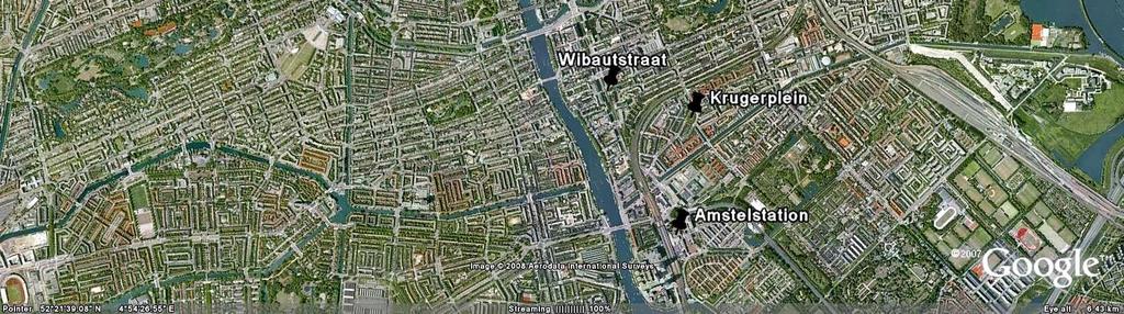
11 The test areas
12 Methods applied and put to the test Questionnaires Observation Thinking aloud Video / audio recording Screen logging GPS tracking Mental map drawing Semi-structured interviews

13 Field based usability testing system implemented


14 Installing / checking equipment Field survey execution Observing the users User Observer
 What information is")
15 Field survey execution (cnt.) What information is recorded?
16 Results The types of landmarks and features that helped the test persons to orientate and navigate during the tests were the canals, the road patterns and sizes, the street names and the parks / squares and roundabouts Landmarks that would help them but were not (always) available on the map displays are the bridges, pedestrian paths crossing roads, important buildings, such as municipal offices, or tall buildings that are visible from a distance Specific landmarks that they expect to come across in order to help them to find their way in an unfamiliar city are big shops and easily distinguishable restaurants, such as fast food branches, churches, noticeable monuments, canals, bridges and parks Test persons did not find actual difference between smooth zooming and step-wise zooming A plethora of 3D models of buildings on the map was confusing, and only a few (important) of them should remain visible Photos of important buildings (such as corner / easily recognizable buildings) more preferable than 3D models The development of their mental maps based on landmarks was decelerated by their looking at the mobile screen most of the time. The majority of test persons argued that if they had used a paper map (or no map at all) they would have developed, combined and memorized more landmarks. The test persons would prefer a map continuously rotating towards the direction of their movement and towards their point of view when they are not moving as well they agreed that frequent zooming in and out is required in order not to lose the contact between reality and the maps in their minds except some important landmarks were visible in many scales
17 Mental map drawings analysis Squares / parks canalmain roads Railways Tall buildings TP2 TP5
18 Conclusion Determination of the types of landmarks that support user geo-identification was feasible Representation of these landmarks as a combination of unique icons and popping-up windows showing pictorial and text information was preferable The zoom levels that are mostly used and the landmarks and information that is missing in specific types of points of confusion can be determined by video recording analysis Further research on smooth zooming usability and proper visualization of environmental and mental landmarks needed Finding proper ways to connect the real and virtual geographic worlds that the user of geo-mobile applications interfaces with, could be one of the keys to developing more usable geo-mobile applications
19 TU Vienna presentation 17 th July 2008 Thank you for your attention! INTERNATIONAL INSTITUTE FOR GEO-INFORMATION SCIENCE AND EARTH OBSERVATION
From map use research to usability research in geo-information processing
 Corné van Elzakker From map use research to usability research in geo-information processing INTERNATIONAL INSTITUTE FOR GEO-INFORMATION SCIENCE AND EARTH OBSERVATION International Institute for Geo-Information
From User Requirements Analysis to Conceptual Design of a Mobile Augmented Reality Tool to be used in an Urban Geography Fieldwork Setting
 From User Requirements Analysis to Conceptual Design of a Mobile Augmented Reality Tool to be used in an Urban Geography Fieldwork Setting Xiaoling Wang, Corné P.J.M. van Elzakker, Menno-Jan Kraak 2016
Interaction of Mobile Camera Devices with physical maps
 Interaction of Mobile Camera Devices with physical maps Johannes Schöning, Antonio Krüger, Hans Jörg Müller {j.schoening, antonio.krueger, joerg.mueller}@uni-muenster.de Abstract Traditional paper-based
GIScience & Mobility. Prof. Dr. Martin Raubal. Institute of Cartography and Geoinformation SAGEO 2013 Brest, France
 GIScience & Mobility Prof. Dr. Martin Raubal Institute of Cartography and Geoinformation mraubal@ethz.ch SAGEO 2013 Brest, France 25.09.2013 1 www.woodsbagot.com 25.09.2013 2 GIScience & Mobility Modeling
Cartographic and Geospatial Futures
 Cartographic and Geospatial Futures 1. Web Cartography, WebGIS, & Virtual Globes--New Roles for Maps, GIS, and GIS professionals 2. Map Mashups, the Neo Neo-geography Movement, & Crowd-sourcing Geospatial
Research Group Cartography
 Research Group Cartography Research Group Cartography Towards supporting wayfinding LBS components 1. Mobile devices 2. Communication Network 3. Positioning Component 4. Service and Application Provider
Where do I live? Geography teaching resource. Paula Owens. Primary. Locating own home address
 Where do I live? Locating own home address Paula Owens Geography teaching resource Primary Digimap for Schools Geography Resources Where do I live Level Context Location Primary Locating own home address
The maps in this resource can be freely modified and reproduced in the classroom only.
 Teacher's Notes In this activity, students work collaboratively to explore sections of old and new maps. By closely examining these documents, students learn to see maps as more than just tools for locating
A new type of RICEPOTS
 A new type of RICEPOTS Alan Parkinson Geography teaching resource College Crown Copyright and Database Right 2014. Ordnance Survey (Digimap Licence) This is one of a series of teaching resources for use
Psycho-pleasurability of Maps for Wayfinding
 Psycho-pleasurability of Maps for Wayfinding Chun-wen CHEN*, Manlai YOU**, Shang-chia CHIOU*** Graduate School of esign National Yunlin University of Science and Technology, Taiwan *g9030805@yuntech.edu.tw,
CROSS-CULTURAL ISSUES IN CONTEXT BASED MAPPING
 CROSS-CULTURAL ISSUES IN CONTEXT BASED MAPPING Takashi MORITA Department of Civil and Environmental Engineering, Hosei University 2-17-1, Fujimi, Chiyoda-ku, 102-8160, Tokyo, Japan morita@hosei.ac.jp Abstract
Module 4 Educator s Guide Overview
 Module 4 Educator s Guide Overview Paths Module Overview This module looks at many different kinds of paths and considers why paths are where they are and how they look from space. Paths are usually not
The Recognition of Temporal Patterns in Pedestrian Behaviour Using Visual Exploration Tools
 The Recognition of Temporal Patterns in Pedestrian Behaviour Using Visual Exploration Tools I. Kveladze 1, S. C. van der Spek 2, M. J. Kraak 1 1 University of Twente, Faculty of Geo-Information Science
Cognitive Engineering for Geographic Information Science
 Cognitive Engineering for Geographic Information Science Martin Raubal Department of Geography, UCSB raubal@geog.ucsb.edu 21 Jan 2009 ThinkSpatial, UCSB 1 GIScience Motivation systematic study of all aspects
Lesson Plan 2 - Middle and High School Land Use and Land Cover Introduction. Understanding Land Use and Land Cover using Google Earth
 Understanding Land Use and Land Cover using Google Earth Image an image is a representation of reality. It can be a sketch, a painting, a photograph, or some other graphic representation such as satellite
Spatial Knowledge Acquisition in the Context of GPS-based Pedestrian Navigation
 Spatial Knowledge Acquisition in the Context of GPS-based Pedestrian Navigation Haosheng Huang, Manuela Schmidt, Georg Gartner Institute of Geoinformation and Cartography, Vienna University of Technology
Geographical Bias on Social Media and Geo-Local Contents System with Mobile Devices
 212 45th Hawaii International Conference on System Sciences Geographical Bias on Social Media and Geo-Local Contents System with Mobile Devices Kazunari Ishida Hiroshima Institute of Technology k.ishida.p7@it-hiroshima.ac.jp
Chapter 1. GIS Fundamentals
 1. GIS Overview Chapter 1. GIS Fundamentals GIS refers to three integrated parts. Geographic: Of the real world; the spatial realities, the geography. Information: Data and information; their meaning and
Supporting movement patterns research with qualitative sociological methods gps tracks and focus group interviews. M. Rzeszewski, J.
 Supporting movement patterns research with qualitative sociological methods gps tracks and focus group interviews M. Rzeszewski, J. Kotus Adam Mickiewicz University, ul. Dziegielowa 27, 61-680 Poznan,
EYE-TRACKING TESTING OF GIS INTERFACES
 Geoinformatics EYE-TRACKING TESTING OF GIS INTERFACES Bc. Vaclav Kudelka Ing. Zdena Dobesova, Ph.D. Department of Geoinformatics, Palacký University, Olomouc, Czech Republic ABSTRACT Eye-tracking is currently
GEOGRAPHIC INFORMATION SYSTEMS Session 8
 GEOGRAPHIC INFORMATION SYSTEMS Session 8 Introduction Geography underpins all activities associated with a census Census geography is essential to plan and manage fieldwork as well as to report results
Enhance Security, Safety and Efficiency With Geospatial Visualization
 Areas within 10 minutes of an exit are emphasized on this map, to give an indication of how accessible neighborhoods are by highway. The colors represent 1, 3, 5 and 10 minute increments from the exits.
Interactive Visualization Tool (InViTo)
") Interactive Visualization Tool (InViTo) Stefano Pensa To cite this report: Stefano Pensa (2012) Interactive Visualization Tool (InViTo), in Angela Hull, Cecília Silva and Luca Bertolini (Eds.) Accessibility
Interactive Visualization Tool (InViTo) Stefano Pensa To cite this report: Stefano Pensa (2012) Interactive Visualization Tool (InViTo), in Angela Hull, Cecília Silva and Luca Bertolini (Eds.) Accessibility
Evaluating e-government : implementing GIS services in Municipality
 Evaluating e-government : implementing GIS services in Municipality Municipality of Thessaloniki - G.I.S. Unit Misirloglou Symeon Head of the GIS Unit ESRI UC - 2016 The GIS Section - subset of the department
A thesis submitted in fulfillment of the requirements. for the degree of Master of Science in Geospatial Technologies.
 AUGMENTING PEDESTRIAN NAVIGATION SYSTEMS WITH CONTEXT-AWARE DISPLAY OF POIS A thesis submitted in fulfillment of the requirements for the degree of Master of Science in Geospatial Technologies in the GEOTEC
GENERALIZATION APPROACHES FOR CAR NAVIGATION SYSTEMS A.O. Dogru 1, C., Duchêne 2, N. Van de Weghe 3, S. Mustière 2, N. Ulugtekin 1
 GENERALIZATION APPROACHES FOR CAR NAVIGATION SYSTEMS A.O. Dogru 1, C., Duchêne 2, N. Van de Weghe 3, S. Mustière 2, N. Ulugtekin 1 1 Istanbul Technical University, Cartography Division, Istanbul, Turkey
Sample assessment task. Task details. Content description. Year level 7
 Sample assessment task Year level 7 Learning area Subject Title of task Task details Description of task Type of assessment Purpose of assessment Assessment strategy Evidence to be collected Suggested
GEOGRAPHICAL INFORMATION SYSTEMS. GIS Foundation Capacity Building Course. Introduction
 GEOGRAPHICAL INFORMATION SYSTEMS. GIS Foundation Capacity Building Course. Introduction In recent times digital mapping has become part and parcel of our daily lives with experience from Google Maps on
A Street Named for a King
 A Street Named for a King Dr. Jerry Mitchell University of South Carolina OVERVIEW This lesson adapts the work of Dr. Derek Alderman, a geographer who has used the Martin Luther King, Jr. street-naming
Building a National Data Repository
 Building a National Data Repository Mladen Stojic, Vice President - Geospatial 1/30/2013 2012 Intergraph Corporation 1 Information has meaning and gives power only when shared and distributed. Information,
Land Navigation Table of Contents
 Land Navigation Table of Contents Preparatory Notes to Instructor... 1 Session Notes... 5 Learning Activity: Grid Reference Four Figure... 7 Learning Activity: Grid Reference Six Figure... 8 Learning Activity:
Smart Data Collection and Real-time Digital Cartography
 Smart Data Collection and Real-time Digital Cartography Yuji Murayama and Ko Ko Lwin Division of Spatial Information Science Faculty of Life and Environmental Sciences University of Tsukuba IGU 2013 1
A Preliminary Model of Community-based Integrated Information System for Urban Spatial Development
 A Preliminary Model of Community-based Integrated Information System for Urban Spatial Development Bauni HAMID 1, Devin DEFRIZA 2 1 2 CAITAD (Center of Applied Information Technology in Planning and Design),
Landmarks Paula Owens 5 7 years
 Landmarks Paula Owens Geography teaching resource 5 7 years This is one of a series of teaching resources for use with Digimap for Schools. For more details about this service, visit http://digimapforschools.edina.ac.uk
Map-Based Navigation in a Graphical MOO
 Map-Based Navigation in a Graphical MOO Wendy A. Schafer, Doug A. Bowman, and John M. Carroll Center for Human-Computer Interaction Department of Computer Science Virginia Tech Blacksburg, VA 24061 USA
AUTOMATIC GENERATION OF 3D CITY MODELS AND RELATED APPLICATIONS
 International Archives of the Photogrammetry, Remote Sensing and Spatial Information Sciences, Vol. XXXIV-5/W10 AUTOMATIC GENERATION OF 3D CITY MODELS AND RELATED APPLICATIONS Y. Takase a, *, N. Sho a,
INTELLIGENT MAPS FOR VISION ENHANCED MOBILE INTERFACES IN URBAN SCENARIOS
 INTELLIGENT MAPS FOR VISION ENHANCED MOBILE INTERFACES IN URBAN SCENARIOS Linde Vande Velde 1*, Patrick Luley 2, Alexander Almer 2, Christin Seifert 2, and Lucas Paletta 2** 1. Tele Atlas, Gent, Belgium
Improving the travel time prediction by using the real-time floating car data
 Improving the travel time prediction by using the real-time floating car data Krzysztof Dembczyński Przemys law Gawe l Andrzej Jaszkiewicz Wojciech Kot lowski Adam Szarecki Institute of Computing Science,
Identifying Audit, Evidence Methodology and Audit Design Matrix (ADM)
") 11 Identifying Audit, Evidence Methodology and Audit Design Matrix (ADM) 27/10/2012 Exercise XXX 2 LEARNING OBJECTIVES At the end of this session participants will be able to: 1. Identify types and sources
11 Identifying Audit, Evidence Methodology and Audit Design Matrix (ADM) 27/10/2012 Exercise XXX 2 LEARNING OBJECTIVES At the end of this session participants will be able to: 1. Identify types and sources
Mobility Analytics through Social and Personal Data. Pierre Senellart
 Mobility Analytics through Social and Personal Data Pierre Senellart Session: Big Data & Transport Business Convention on Big Data Université Paris-Saclay, 25 novembre 2015 Analyzing Transportation and
Turn Left after the WC, and Use the Lift to Go to the 2nd Floor Generation of Landmark-Based Route Instructions for Indoor Navigation
 International Journal of Geo-Information Article Turn Left after the WC, and Use the Lift to Go to the 2nd Floor Generation of Landmark-Based Route Instructions for Indoor Navigation Irene Fellner 1, Haosheng
Google Maps and Beyond
 Google Maps and Beyond Aaron Paul First American Title apaul@firstam.com 2015 APRA Symposium Association of Professional Reserve Analysts May 2 nd, 2015 Google Maps and Beyond - Overview Business case
GIS Boot Camp for Education June th, 2011 Day 1. Instructor: Sabah Jabbouri Phone: (253) x 4854 Office: TC 136
 x 4854 Office: TC 136") GIS Boot Camp for Education June 27-30 th, 2011 Day 1 Instructor: Sabah Jabbouri Phone: (253) 833-9111 x 4854 Office: TC 136 Email: sjabbouri@greenriver.edu http://www.instruction.greenriver.edu/gis/ Summer
GIS Boot Camp for Education June 27-30 th, 2011 Day 1 Instructor: Sabah Jabbouri Phone: (253) 833-9111 x 4854 Office: TC 136 Email: sjabbouri@greenriver.edu http://www.instruction.greenriver.edu/gis/ Summer
Collection and Analyses of Crowd Travel Behaviour Data by using Smartphones
 Collection and Analyses of Crowd Travel Behaviour Data by using Smartphones Rik Bellens 1 Sven Vlassenroot 2 Sidharta Guatama 3 Abstract: In 2010 the MOVE project started in the collection and analysis
Sample. Contents SECTION 1: PLACE NAMES 6 SECTION 2: CONNECTING TO PLACES 21 SECTION 3: SPACES: NEAR AND FAR 53
 Contents Teachers' Notes 4 National Curriculum Links 5 SECTION 1: PLACE NAMES 6 Teachers' Notes 7-8 Activities Names Of Places 9 Place Names Are Important 1 10 Place Names Are Important 2 11 The Meanings
Digital Tax Maps Westport Island Project Summary
 Digital Tax Maps Westport Island Project Summary Presented to the: Mid-Coast Regional Planning Commission Creating GIS-Based Digital Tax Maps And Linked Assessment Records For Small Towns on a Budget Dennis
Elephant Rocks State Park (Missouri) Virtual Trip
 Virtual Trip") Elephant Rocks State Park (Missouri) Virtual Trip Objectives 1. Explain how the observed shapes, textures, and patterns of rock indicate the age of the earth and the large scale of geologic time. 2. Describe
Elephant Rocks State Park (Missouri) Virtual Trip Objectives 1. Explain how the observed shapes, textures, and patterns of rock indicate the age of the earth and the large scale of geologic time. 2. Describe
GIS & E-Marketing. Presented by: Dr. Mark R. Leipnik & Dr. Sanjay Mehta Dept. of Geography & Dept. of Marketing Sam Houston State University
 GIS & E-Marketing Presented by: Dr. Mark R. Leipnik & Dr. Sanjay Mehta Dept. of Geography & Dept. of Marketing Sam Houston State University Presentation is based on a chapter in the fourth-coming book:
BOUNDARY MAP USER GUIDE
 BOUNDARY MAP USER GUIDE Get Exploring. Boundaries. The Northern Ontario Boundary Map provides users with the ability to explore the many community, administrative and service provider boundaries in the
REPORT ON INVESTMENTS
 REPORT ON INVESTMENTS D.T2.3.3 Investments for technical equipment for the implementation of Web-GIS platform in Mantova 1 Local support group designing Mantova Web-GIS platform. Picture by Maria Giulia
HIGH RESOLUTION BASE MAP: A CASE STUDY OF JNTUH-HYDERABAD CAMPUS
 HIGH RESOLUTION BASE MAP: A CASE STUDY OF JNTUH-HYDERABAD CAMPUS K.Manjula Vani, Abhinay Reddy, J. Venkatesh, Ballu Harish and R.S. Dwivedi ABSTRACT The proposed work High Resolution Base map: A Case study
Exploit your geodata to enable smart cities and countries
 Exploit your geodata to enable smart cities and countries Carsten Rönsdorf, Head of Advisory Services Middle East Practice Manager Future Cities, standards and 3D 24 November 2014 Importance of Standards
Data Aggregation with InfraWorks and ArcGIS for Visualization, Analysis, and Planning
 Data Aggregation with InfraWorks and ArcGIS for Visualization, Analysis, and Planning Stephen Brockwell President, Brockwell IT Consulting, Inc. Join the conversation #AU2017 KEYWORD Class Summary Silos
2-4 April 2019 Taets Art and Event Park, Amsterdam CLICK TO KNOW MORE
 Co-Host Host 2-4 April 2019 Taets Art and Event Park, Amsterdam CLICK TO KNOW MORE Delhi Jal Board, INDIA Improving Revenue Management for Urban Water Supply through Spatially Enabled Systems: Applied
The CSC Interface to Sky in Google Earth
 The CSC Interface to Sky in Google Earth CSC Threads The CSC Interface to Sky in Google Earth 1 Table of Contents The CSC Interface to Sky in Google Earth - CSC Introduction How to access CSC data with
Unit 1, Lesson 2. What is geographic inquiry?
 What is geographic inquiry? Unit 1, Lesson 2 Understanding the way in which social scientists investigate problems will help you conduct your own investigations about problems or issues facing your community
Introduction to ArcGIS Server Development
 Introduction to ArcGIS Server Development Kevin Deege,, Rob Burke, Kelly Hutchins, and Sathya Prasad ESRI Developer Summit 2008 1 Schedule Introduction to ArcGIS Server Rob and Kevin Questions Break 2:15
Test and Evaluation of an Electronic Database Selection Expert System
 282 Test and Evaluation of an Electronic Database Selection Expert System Introduction As the number of electronic bibliographic databases available continues to increase, library users are confronted
Google Earth. Overview: Targeted Alaska Grade Level Expectations: Objectives: Materials: Grades 5-8
 Overview: Students become familiar with using the Google Earth interface to navigate around the planet. Using the zoom and tilt features, students practice moving around the planet with the navigation
A BASE SYSTEM FOR MICRO TRAFFIC SIMULATION USING THE GEOGRAPHICAL INFORMATION DATABASE
 A BASE SYSTEM FOR MICRO TRAFFIC SIMULATION USING THE GEOGRAPHICAL INFORMATION DATABASE Yan LI Ritsumeikan Asia Pacific University E-mail: yanli@apu.ac.jp 1 INTRODUCTION In the recent years, with the rapid
Write a report (6-7 pages, double space) on some examples of Internet Applications. You can choose only ONE of the following application areas:
 on some examples of Internet Applications. You can choose only ONE of the following application areas:") UPR 6905 Internet GIS Homework 1 Yong Hong Guo September 9, 2008 Write a report (6-7 pages, double space) on some examples of Internet Applications. You can choose only ONE of the following application
UPR 6905 Internet GIS Homework 1 Yong Hong Guo September 9, 2008 Write a report (6-7 pages, double space) on some examples of Internet Applications. You can choose only ONE of the following application
CLAREMONT MASTER PLAN 2017: LAND USE COMMUNITY INPUT
 Planning and Development Department 14 North Street Claremont, New Hampshire 03743 Ph: (603) 542-7008 Fax: (603) 542-7033 Email: cityplanner@claremontnh.com www.claremontnh.com CLAREMONT MASTER PLAN 2017:
Part 2 Practise Your Skills
 Part 2 Practise Your Skills In this section of Learn Smart, you will have the opportunity to use a wide variety of reading strategies read and understand different texts and visual information ask questions,
1. Origins of Geography
 II. ORIGINS AND BRANCHES OF GEOGRAPHY My Notes A. Origins of Geography Unit One 6 Before carefully examining the tools of the geographer, it would be useful to examine the origins and roots of this ancient
Your Virtual Workforce. On Demand. Worldwide. COMPANY PRESENTATION. clickworker GmbH 2017
 Your Virtual Workforce. On Demand. Worldwide. COMPANY PRESENTATION 2017 CLICKWORKER AT A GLANCE Segment: Paid Crowdsourcing / Microtasking Services: Text Creation (incl. SEO Texts), AI-Training Data, Internet
Multi-cultural Aspects of Spatial Knowledge
 Multi-cultural Aspects of Spatial Knowledge Andrew U. Frank Geoinformation TU Vienna frank@geoinfo.tuwien.ac.at www.geoinfo.tuwien.ac.at Andrew Frank 1 Overview 1. What is culture? 2. Cultural influences
MODERNIZATION OF THE MUNICIPAL MAPPING USING HIGH END GNSS SYSTEM AND GIS SOFTWARE
 MODERNIZATION OF THE MUNICIPAL MAPPING USING HIGH END GNSS SYSTEM AND GIS SOFTWARE Mr. R. A. R. Khan Assistant Engineer, Sewerage Utility Management Centre (SUMC) Municipal Corporation Of Greater Mumbai
CARTOGRAPHY in a Web World
 CARTOGRAPHY in a Web World Nationale GI Minor BAREND KÖBBEN b.j.kobben@utwente.nl Agenda Short introduction to ITC and me Cartography: communicating spatial data Changing GIS & Cartography technology:
DGS Digital Geologic Information Resource (DGIR) User Guide
 User Guide") DGS Digital Geologic Information Resource (DGIR) User Guide Developed by the Delaware Geological Survey. Revised January 2012. TABLE OF CONTENTS I. INTRODUCTION II. DGIR LAYOUT III. TOOLBARS IV. USING
DGS Digital Geologic Information Resource (DGIR) User Guide Developed by the Delaware Geological Survey. Revised January 2012. TABLE OF CONTENTS I. INTRODUCTION II. DGIR LAYOUT III. TOOLBARS IV. USING
International Archives of Photogrammetry and Remote Sensing. Vol. XXXII, Part 5. Hakodate 1998
 International Archives of Photogrammetry and Remote Sensing. Vol. XXXII, Part 5. Hakodate 1998 REAL-TIME MEASUREMENT OF ALTITUDE DATA USING THE ACCELEROMETER Hidetoshi SUZUKI Dep. Civil Eng., Graduate
Place Syntax Tool (PST)
") Place Syntax Tool (PST) Alexander Ståhle To cite this report: Alexander Ståhle (2012) Place Syntax Tool (PST), in Angela Hull, Cecília Silva and Luca Bertolini (Eds.) Accessibility Instruments for Planning
Place Syntax Tool (PST) Alexander Ståhle To cite this report: Alexander Ståhle (2012) Place Syntax Tool (PST), in Angela Hull, Cecília Silva and Luca Bertolini (Eds.) Accessibility Instruments for Planning
Introduction to Field Data Collection
 Introduction to Field Data Collection Dr. Yuji Murayama (Professor) Dr. Ko Ko Lwin (JSPS Postdoctoral Researcher) Division of Spatial Information Science Graduate School of Life and Environmental Sciences
Map reading made easy
 Map reading made easy 1. What is a map? A map is simply a drawing or picture (in 2-D) of a landscape or area of a country (in 3-D). It could be anything from a sketch map for a visitor to find your school
Assessing the benefit of green infrastructure/wsud on urban microclimate
 Supporting the strategic planning of City of Unley (SA) towards a water sensitive city by quantifying the urban microclimate benefits using the Water Sensitive Cities Modelling Toolkit A Collaboration
Digital Wetlands. Bringing the Field into the Office Through GIS
 Digital Wetlands Bringing the Field into the Office Through GIS Maryland Department of the Environment Wetlands and Waterways Program MDE's Wetlands and Waterways Program seeks to conserve valuable aquatic
Map reading made easy
 Map reading made easy Maps can be great fun and they can lead you to all sorts of discoveries. They can help you get to know an area really well, because they pinpoint interesting places that are often
My Map Activity MINNESOTA SOCIAL STUDIES STANDARDS & BENCHMARKS
 My Map Activity OVERVIEW & OBJECTIVES Students will learn the basics of Google Maps while using geospatial data to create their neighborhood map with the places they spend time. They will also collect
GIS CONCEPTS Part I. GIS ON THE WEB Part II
 Week 2 GIS CONCEPTS Part I GIS ON THE WEB Part II topics of the week part I GIS functions and GIS data Spatial relationships Organizing convention for spatial data Store Information by thematic layers
ADVANCES OF INTERDISCIPLINARY CARTOGRAPHY IN THE HIMALAYAN MOUNTAINS
 Geographia Technica, Special Issue, 2010, pp. 120 to 125 ADVANCES OF INTERDISCIPLINARY CARTOGRAPHY IN THE HIMALAYAN MOUNTAINS David SCHOBESBERGER 1, Karel KRIZ 1 ABSTRACT: This paper follows up on the
Neighborhood Locations and Amenities
 University of Maryland School of Architecture, Planning and Preservation Fall, 2014 Neighborhood Locations and Amenities Authors: Cole Greene Jacob Johnson Maha Tariq Under the Supervision of: Dr. Chao
Give 4 advantages of using ICT in the collection of data. Give. Give 4 disadvantages in the use of ICT in the collection of data
 Give 4 advantages of using ICT in the collection of data can use a handheld GPS to get accurate location information which can be used to show data linked to specific locations within a GIS can collect
Unit 1, Lesson 3 What Tools and Technologies Do Geographers Use?
 Unit 1, Lesson 3 What Tools and Technologies Do Geographers Use? Geographers use a variety of tools and technologies in investigating geographic questions. Maps and globes both represent the earth, but
Navigating to Success: Finding Your Way Through the Challenges of Map Digitization
 Library Faculty Presentations Library Faculty/Staff Scholarship & Research 10-15-2011 Navigating to Success: Finding Your Way Through the Challenges of Map Digitization Cory K. Lampert University of Nevada,
Scout Skills Mapping QUALITY TRAINING FOR QUALITY SCOUTING INFORMATION SHEET
 Scout Skills Mapping INFORMATION SHEET A map is a picture of a given area of what the ground looks like from directly above. When undertaking a journey, we need to be able to find our way around competently,
Introduction to Geographic Information Systems Dr. Arun K Saraf Department of Earth Sciences Indian Institute of Technology, Roorkee
 Introduction to Geographic Information Systems Dr. Arun K Saraf Department of Earth Sciences Indian Institute of Technology, Roorkee Lecture 01 What is Geographic Information Systems? I welcome to this
Explore. history landscapes family.
 Explore history landscapes family www.explorethepast.co.uk Contents From the team Section 1 Researching Worcestershire Section 2 Local Studies & Archaeology Reference Library Section 3 Maps and plans Accessing
Many Ways to Name a Place
 Your web browser (Safari 7) is out of date. For more security, comfort and Activityapply the best experience on this site: Update your browser Ignore Many Ways to Name a Place What are the names for the
USS Arizona Drawings and Underwater GPS Surveys Linked by ArcIMS
 ESRI UC2004 USS Arizona Drawings and Underwater GPS Surveys Linked by ArcIMS Tim Smith National Park Service Matt Brown Northrop Grumman Information Technology Outline! Introduction! Geodatabase Development!
Cognitive Readability Enhancing of Cartographic Maps for Pedestrian Navigation
 International Journal of Brain and Cognitive Sciences 2012, 1(3): 11-17 DOI: 10.5923/j.ijbcs.20120103.01 Cognitive Readability Enhancing of Cartographic Maps for Pedestrian Navigation Ali Khazravi, Farid
What is sampling? shortcut whole population small part Why sample? not enough; time, energy, money, labour/man power, equipment, access measure
 What is sampling? A shortcut method for investigating a whole population Data is gathered on a small part of the whole parent population or sampling frame, and used to inform what the whole picture is
Business Model for sustainable regional development by tourism
 Business Model for sustainable regional development by tourism Why EuroVeloPark Banat? Steps to Success Action proposal 1. Drawing of the Basis Map 2. Data Acquisition, POIs, etc. 3. Printed Map and Distribution
Your web browser (Safari 7) is out of date. For more security, comfort and. the best experience on this site: Update your browser Ignore
 is out of date. For more security, comfort and. the best experience on this site: Update your browser Ignore") Your web browser (Safari 7) is out of date. For more security, comfort and Activityengage the best experience on this site: Update your browser Ignore Introduction to GIS What is a geographic information
Your web browser (Safari 7) is out of date. For more security, comfort and Activityengage the best experience on this site: Update your browser Ignore Introduction to GIS What is a geographic information
Virtual 3D Cities. Chapter VIII. Virtual 3D Cities. 8.1 Introduction. Components. Chapter VIII: Virtual 3D Cities 1
 Chapter VIII Virtual 3D Cities 8.1 Introduction 8.2 CityGML 8.3 Google Earth 8.4 Virtual Earth 8.5 Conclusions Virtual 3D Cities 8.1 Introduction 3D Visualization of cities Languages such as CityGML New
Tutorial: Urban Trajectory Visualization. Case Studies. Ye Zhao
 Case Studies Ye Zhao Use Cases We show examples of the web-based visual analytics system TrajAnalytics The case study information and videos are available at http://vis.cs.kent.edu/trajanalytics/ Porto
GIS = Geographic Information Systems;
 What is GIS GIS = Geographic Information Systems; What Information are we talking about? Information about anything that has a place (e.g. locations of features, address of people) on Earth s surface,
Diffusion of GIS in Public Policy Doctoral Program
 Diffusion of GIS in Public Policy Doctoral Program By Fulbert Namwamba PhD Southern University This presentation demonstrate how GIS was introduced in the Public Policy Doctoral Program at Southern University,
FIG WW Evaluation of Mobile Mapping System (MMS) Survey for Public Housing Estates in Hong Kong. Winnie SHIU. Senior Land Surveyor.
 Survey for Public Housing Estates in Hong Kong. Winnie SHIU. Senior Land Surveyor.") FIG WW 2012 Evaluation of Mobile Mapping System (MMS) Survey for Public Housing Estates in Hong Kong Winnie SHIU Senior Land Surveyor 9 May 2012 Housing Department 1953 Big Fire in Squatter Area Constructed
FIG WW 2012 Evaluation of Mobile Mapping System (MMS) Survey for Public Housing Estates in Hong Kong Winnie SHIU Senior Land Surveyor 9 May 2012 Housing Department 1953 Big Fire in Squatter Area Constructed
Developing a Community Geographical Information System (GIS) in Rural India
 in Rural India") Developing a Community Geographical Information System (GIS) in Rural India Before rushing off and describing the unique challenges of developing a small scale GIS system India I better first describe
Developing a Community Geographical Information System (GIS) in Rural India Before rushing off and describing the unique challenges of developing a small scale GIS system India I better first describe
RGI: geo-visualization RGI. The road to. Ron van Lammeren. Centre for Geo-Information 1RL01
 : geo-visualization The road to. Ron van Lammeren 300505 1RL01 Contents Geo-visualisation Types of geo-visualisation Interacting by interfaces Role of geo-visualisation Usability and perception Constructing
Landmark-based pedestrian navigation
 Landmark-based pedestrian navigation Anahid Basiri, Adam Winstanley, Pouria Amirian Department of Computer Science, National University of Ireland Maynooth (NUIM) Maynooth, Ireland Tel. (+353 17084794)