2-4 April 2019 Taets Art and Event Park, Amsterdam CLICK TO KNOW MORE
|
|
|
- Elijah McCormick
- 5 years ago
- Views:
Transcription


1 Co-Host Host 2-4 April 2019 Taets Art and Event Park, Amsterdam CLICK TO KNOW MORE
 Vikram Singh, Superintending Engineer 1")
2 Delhi Jal Board, INDIA Improving Revenue Management for Urban Water Supply through Spatially Enabled Systems: Applied experience in Delhi City B.S. Jaglan, Director(Revenue) Vikram Singh, Superintending Engineer 1
3 Presentation Overview Revenue Management System (RMS )Overview RMS Salient Features RMS Portal One Stop Place For Consumer RMS-GIS Architecture Consumer Mapping Process GIS Application RMS - Benefits 2
4 About Delhi Jal Board DJB established on 6 th April, 1998 by an Act of Delhi Assembly Supplies potable water to 17.0 million population MGD Water sources- Yamuna River, Bhakhra storage, upper Ganga and Sub- surface Treatment and disposal of waste water Introduction of New Revenue Management System 3
5 RMS Overview Automation of Metering, Billing, Collection and Customer Care functions for DJB Document Management System for digitization and storage of old water connection files (20 million pages) Infrastructure setup and Networking across 32 Zonal offices GIS Interface Address Standardization, Customer Mapping & GIS Application RMS launched in July


6 RMS Overview (Continued ) RMS Portal MIS REVENUE MANAGEMENT SYSTEM (RMS) Metering Billing Collections Customer Care DJB Counter Banks E-Kiosk Jeevan Centre HHD In one GIS month 5
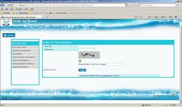
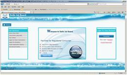
7 RMS - Salient Features RMS Portal One Stop Place for Delhi Jal Board Consumers for all their needs Apply online for New Water or Sewerage connection Request for Disconnection or Reopening online Raise Mutation request online View Bill details and make Payment Raise Grievance and Track Status New touch points introduced for consumer interaction Web/Portal, Bills on s, SMS Alerts, Helpdesk Handheld devices introduced to facilitate Meter Reading, Spot Billing and Collection at the consumer premise New modes of collection introduced - Net Banking, Credit and Debit cards 6

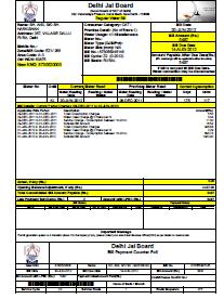
8 RMS Portal One Stop Place For Consumers 7
9 RMS GIS INTERFACE 8
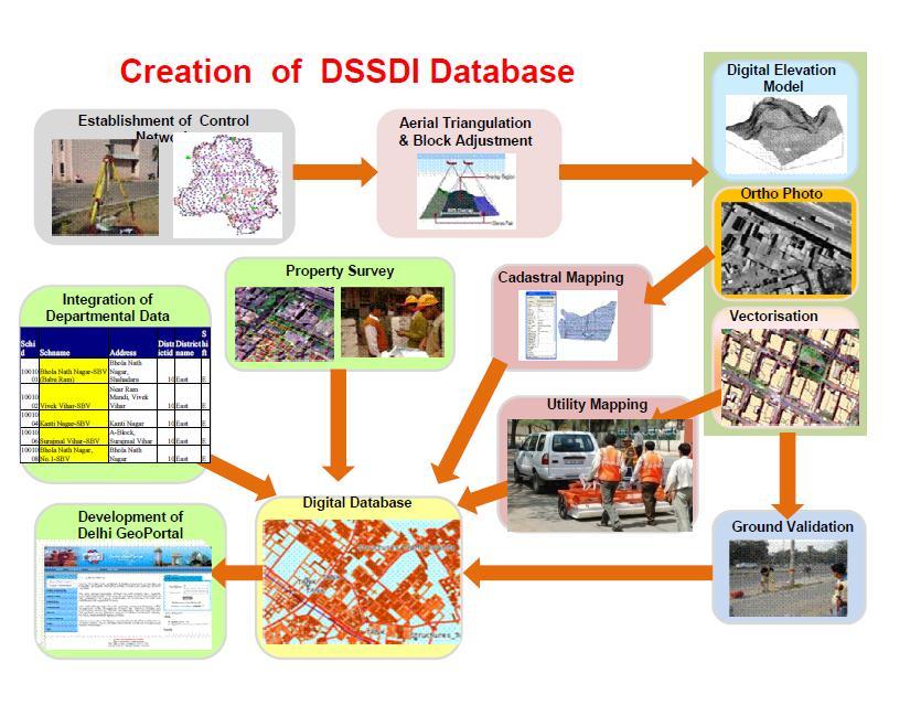
10 RMS GIS OVERVIEW Delhi City GIS Base Map Delhi State Spatial Data Infrastructure (DSSDI) Project created a GIS Base Map of Delhi at the scale of 1:2000 with all building parcels and household units mapped. DJB Consumer Address Standardization and Enrichment DSSDI Base map was used as base for address standardization and enrichment ( 1.9 million consumers) DJB Consumer Mapping An interface developed to map DJB consumers on the GIS Map of Delhi. GIS Application Besides, other GIS layers developed to show percentage collection, areas/ houses without water connections, areas/ houses with larger set of complaints etc. 9
11 10


12 Standardized The Addresses Consumer Mapping Process Map the building units with the address of DJB Customers in its database Enrich DJB s address data based on GIS Base Map data Processed to Map 11

13 Standardization of Address Address Format 12


14 Address - Data Model In the automated enriching process, address data matched based on few fields like shown in below figure. 13


15 Consumer Mapping Process DJB Customer Data Old DJB billing data contains text / csv files with house no, street name customer name etc DSSDI BASE MAP Buildings (Polygon feature class) and Building Units (Point feature class) Attributes Spatial Analysis & Geo coding DJB Consumers mapped on GIS Map (In geospatial formats Shape files) 14
16 GIS Application System Architecture Web Browser/ Application HTTP DJB Environment MapViewer Rendering Engine JDBC DSSDI Base Map Oracle 11g Oracle 11g-SPATIAL ( Customer Data & Billing Data) 15

17 Map Builder with Map Viewer 16
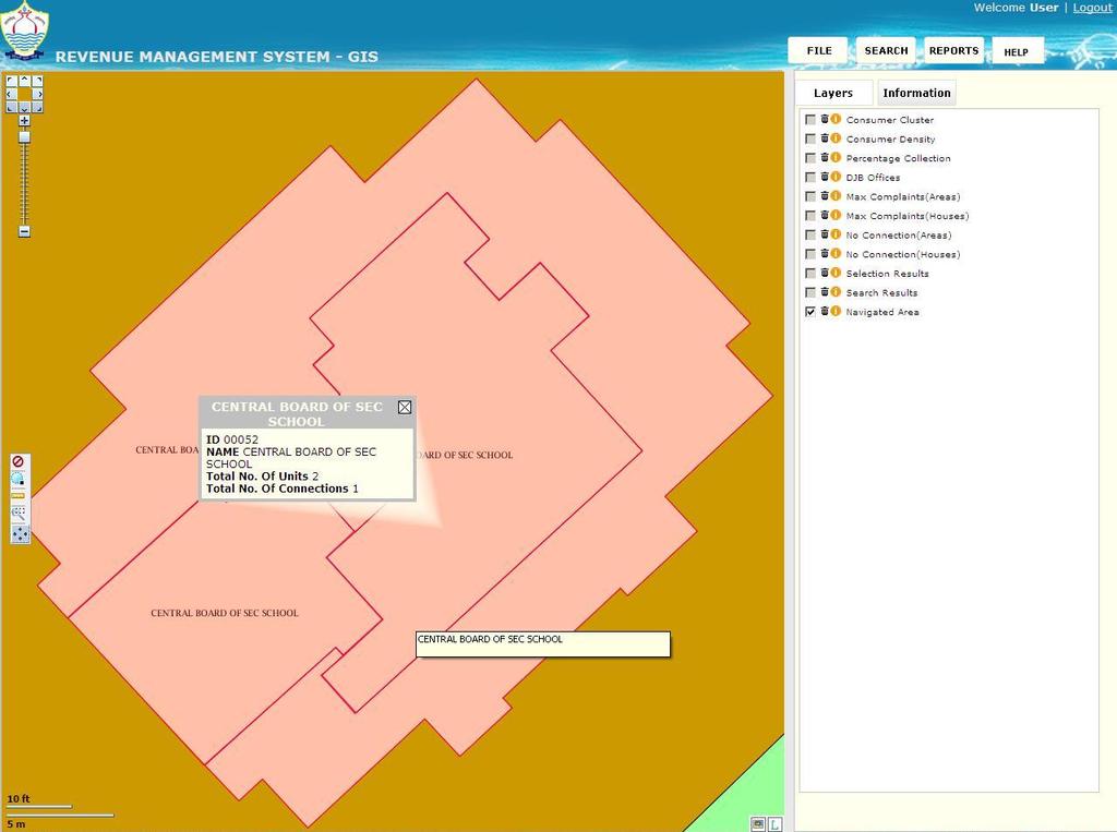
18 RMS-GIS Application Functionalities Area Search Consumer Search By using Consumer Number By using Address By using Old ID s Consumer Cluster Report Percentage Collection Report Consumer Density Complaint Houses Complaint Areas No-Connection Houses No-Connection Areas 17

19 RMS GIS APPLICATION(Home Page) 18

20 Tool Bar & Navigation Bar Navigation Bar Tool Bar Zoom Out Pan Set full Extent Distance Calculator Map Printing Marquee Zoom Clear Selection 19

21 LEGEND FOR MAP 20
22 AREA SEARCH FUNCTIONALITY This search will allow the user to: Navigate to a particular Locality/SubLocality/Block/Building which will be selected by the user from a provided list populated dynamically from the database. The map will be zoomed on to the selected Locality/Building which will provide information about the selected area. 21

23 AREA SEARCH 22
24 Area Search(Continued ) 23
25 Area Search(Continued ) 24

26 Consumer Search: By K Number 25
27 Consumer Search: By K Number(Continued ) 26
 27")
28 Consumer Search: By K Number(Continued ) 27
29 Consumer Search:By Address(Continued ) 28
")
30 Consumer Search:By Address(Continued ) 29
31 Consumer Search:By Old ID(Continued ) 30
32 Consumer Search:By Old ID(Continued ) 31

33 Reports 32
34 Consumer Cluster Report This report will display a dot-map of DJB customers. It will help in identifying the exact location of the customer on the GIS map. On one clicking on an address dot, the complete address of that customer will be displayed in an information window. Consumer Categories - Active - Unbilled - Billed but un paid - Paid - Disconnected 33

35 Consumer Cluster Report 34

36 Consumer Cluster Report 35
")
37 Consumer Cluster Report(Active) 36
")
38 Consumer Cluster Report(Unbilled) 37
")
39 Consumer Cluster Report(UnBilled) 38
40 Percentage Collection Report This reports will provide bar-charts for various attributes at Locality / SubLocality / Block level based on the amount of revenue collected from the customers in a particular area. These charts will be clickable and will provide relevant information (Including Billing details) on clicking. 39
 40")
41 Percentage Collection Report(Continued ) 40


42 Percentage Collection Report(Continued ) 41
43 Consumer Density Report This report will display a color-coded range-map based on the density of DJB customers. The High and Low density areas will be colored with dark and light colors respectively. It will help to identifying the areas having high/low density of customers in a selected area. 42
")
44 Consumer Density Report(Continued) 43
")
45 Consumer Density Report(Continued) 44
46 Types of Complains The following type of consumers complaints are mapped in the GIS Application Change of Address Issue of Duplicate Bills Arrears Disputes Non Receipt of Bill Meter Reading issues Complaints Status Complaint Lodged Investigation Started Meter Testing 45

47 Complaint Houses Report 46
")
48 Complaint Houses Report(Continued ) 47
49 Complaint Houses Report(Continued ) 48
50 Complaint Houses Report(Continued ) 49
51 Complaint Houses Report(Continued ) 50
")
52 Complaint Houses Report(Continued ) 51
53 Complaint Areas(Continued ) 52

54 Complaint Areas(Block Level) 53
55 No Connection Houses(Continued ) 54

56 No Connection Houses(Continued ) 55

57 No Connection Houses(Continued ) 56
58 No Connection Areas(Continued ) 57

59 No Connection Areas(Block Level) 58

60 RMS Benefits Benefits to Citizens Shorter turnaround time in issuing New Water or Sewerage connection Effective, Efficient and Prompt Services Benefits to DJB Widen the coverage of Billing and Collection Spot Billing and Collection New payment modes for Collection introduced Credit, Debit Cards, Net Banking Real time update of Meter Reading from the field or consumer premise through Handheld device Quick grievance redressal through Portal, Customer Care GIS Application benefits This Application provide the user with a bird s eye view of the complete Billing scenario. Generation of Bills on a click of a mouse; Configurable Tariff Structure; Easy to change Help to identifying the areas having high/low density of customers which will help to increase consumer base. Help in identifying areas where revenue generation is low due to Un paid bills/unbilled customers etc. 59

61 Contact details:
for Effective Land Administration
 Role of Geospatial Technology in Land Information System(LIS) for Effective Land Administration Dr. Deb Jyoti Pal Sections Role of GIS in Land Records Proposed Work Flow Case Studies Role of GIS Creating
ArcGIS is Advancing. Both Contributing and Integrating many new Innovations. IoT. Smart Mapping. Smart Devices Advanced Analytics
 ArcGIS is Advancing IoT Smart Devices Advanced Analytics Smart Mapping Real-Time Faster Computing Web Services Crowdsourcing Sensor Networks Both Contributing and Integrating many new Innovations ArcGIS
Water Information Portal User Guide. Updated July 2014
 Water Information Portal User Guide Updated July 2014 1. ENTER THE WATER INFORMATION PORTAL Launch the Water Information Portal in your internet browser via http://www.bcogc.ca/public-zone/water-information
Geo-enabling a Transactional Real Estate Management System A case study from the Minnesota Dept. of Transportation
 Geo-enabling a Transactional Real Estate Management System A case study from the Minnesota Dept. of Transportation Michael Terner Executive Vice President Co-author and Project Manager Andy Buck Overview
Acknowledgments xiii Preface xv. GIS Tutorial 1 Introducing GIS and health applications 1. What is GIS? 2
 Acknowledgments xiii Preface xv GIS Tutorial 1 Introducing GIS and health applications 1 What is GIS? 2 Spatial data 2 Digital map infrastructure 4 Unique capabilities of GIS 5 Installing ArcView and the
Comptroller GIS and Property Data. Ken Morrell Assessment Systems Manager Division of Property Assessments February 22, 2007
 Comptroller GIS and Property Data Ken Morrell Assessment Systems Manager Division of Property Assessments February 22, 2007 Comptroller Divisions Using and Supporting GIS Office of Local Government Implement
Corporate. Information. Railway Infrastructure Administrator. Year indracompany.com
 geospatial and mobility Corporate Geographic Information System of ADIF Railway Infrastructure Administrator. Year 2009-2010 Corporate Geographic Information System of ADIF ADIF. Spanish Administrator
Overview. Everywhere. Over everything.
 Cadenza Desktop Cadenza Web Cadenza Mobile Cadenza Overview. Everywhere. Over everything. The ultimate GIS and reporting suite. Provide, analyze and report data efficiently. For desktop, web and mobile.
One platform for desktop, web and mobile
 One platform for desktop, web and mobile Search and filter Get access to all data thematically filter data in context factually and spatially as well as display it dynamically. Export a selection or send
THE SPATIAL DATA WAREHOUSE OF SEOUL
 THE SPATIAL DATA WAREHOUSE OF SEOUL Jae-Ho Han The Seoul Metropolitan Government Seoul City Hall, Taepyeongno 1(il)-ga, Jung-gu, Seoul 100-744, Korea djhjha@hanmail.net Impyeong Lee Dept. of Geoinformatics,
Write a report (6-7 pages, double space) on some examples of Internet Applications. You can choose only ONE of the following application areas:
 on some examples of Internet Applications. You can choose only ONE of the following application areas:") UPR 6905 Internet GIS Homework 1 Yong Hong Guo September 9, 2008 Write a report (6-7 pages, double space) on some examples of Internet Applications. You can choose only ONE of the following application
UPR 6905 Internet GIS Homework 1 Yong Hong Guo September 9, 2008 Write a report (6-7 pages, double space) on some examples of Internet Applications. You can choose only ONE of the following application
Desktop GIS for Geotechnical Engineering
 Desktop GIS for Geotechnical Engineering Satya Priya Deputy General Manager (Software) RMSI, A-7, Sector 16 NOIDA 201 301, UP, INDIA Tel: +91-120-2511102 Fax: +91-120-2510963 Email: Satya.Priya@rmsi.com
GeoSUR SRTM 30-m / TPS
 GeoSUR SRTM 30-m / TPS Wm Matthew Cushing (USGS) 16 May 2013 U.S. Department of the Interior U.S. Geological Survey SRTM Mission Shuttle Radar Topography Mission (SRTM) Space Shuttle Endeavour during the
Introduction to ArcGIS Server Development
 Introduction to ArcGIS Server Development Kevin Deege,, Rob Burke, Kelly Hutchins, and Sathya Prasad ESRI Developer Summit 2008 1 Schedule Introduction to ArcGIS Server Rob and Kevin Questions Break 2:15
Pegaso map viewer workshop
 PEGASO / 05 Deliverable Plan 2010-12-23 Pegaso Project People for Ecosystem based Governance in Assessing Sustainable development of Ocean and coast Funded by the European Union under FP7 ENV.2009.2.2.1.4
MODERNIZATION OF THE MUNICIPAL MAPPING USING HIGH END GNSS SYSTEM AND GIS SOFTWARE
 MODERNIZATION OF THE MUNICIPAL MAPPING USING HIGH END GNSS SYSTEM AND GIS SOFTWARE Mr. R. A. R. Khan Assistant Engineer, Sewerage Utility Management Centre (SUMC) Municipal Corporation Of Greater Mumbai
Empowering water/wastewater network management with GIS
 Empowering water/wastewater network management with GIS Ioannis Kavouras_GIS Manager Surveying Engineer, MSc, MBA The Company responsible for fresh water distribution & sanitation serving 1.500.000 citizens
Web-GIS based Framework for Solid Waste Complaint Management for Sustainable and Smart City
 Cloud Publications International Journal of Advanced Remote Sensing and GIS 2016, Volume 5, Issue 10, pp. 1930-1936 ISSN 2320-0243, DOI: 10.23953/cloud.ijarsg.71 Research Article Open Access Web-GIS based
ArcGIS GeoAnalytics Server: An Introduction. Sarah Ambrose and Ravi Narayanan
 ArcGIS GeoAnalytics Server: An Introduction Sarah Ambrose and Ravi Narayanan Overview Introduction Demos Analysis Concepts using GeoAnalytics Server GeoAnalytics Data Sources GeoAnalytics Server Administration
Geospatial SDI Portal for effective Governance of Pune METROPOLIS region
 Geospatial SDI Portal for effective Governance of Pune METROPOLIS region Mr. Praveen Gautam Senior Manager 19 th January 2018 PMRDA Overview Provide a Spatial Framework for the entire region with various
OneStop Map Viewer Navigation
 OneStop Map Viewer Navigation» Intended User: Industry Map Viewer users Overview The OneStop Map Viewer is an interactive map tool that helps you find and view information associated with energy development,
User Guide. Affirmatively Furthering Fair Housing Data and Mapping Tool. U.S. Department of Housing and Urban Development
 User Guide Affirmatively Furthering Fair Housing Data and Mapping Tool U.S. Department of Housing and Urban Development December, 2015 1 Table of Contents 1. Getting Started... 5 1.1 Software Version...
Frequently Asked Questions
 Frequently Asked Questions Can I still get paid via direct deposit? Can I use e- wallet to pay for USANA auto ship orders? Can I use e- wallet to pay for USANA products? Can I use e- wallet to pay for
SWAMP GIS: A spatial decision support system for predicting and treating stormwater runoff. Michael G. Wing 1 * and Derek Godwin
 Journal of Spatial Hydrology Vol. 11, No. 2 Fall 2011 SWAMP GIS: A spatial decision support system for predicting and treating stormwater runoff Michael G. Wing 1 * and Derek Godwin Abstract SWAMP GIS
Evaluating e-government : implementing GIS services in Municipality
 Evaluating e-government : implementing GIS services in Municipality Municipality of Thessaloniki - G.I.S. Unit Misirloglou Symeon Head of the GIS Unit ESRI UC - 2016 The GIS Section - subset of the department
GIS Monroe Geographic Information System March 14, 2018
 GIS Monroe Geographic Information System March 14, 2018 Goals Maintain Enterprise/County-wide geo-database Increase spatial accuracy of data Build and acquire more data layers Increase use of GIS; as another
Bentley Map V8i (SELECTseries 3)
") Bentley Map V8i (SELECTseries 3) A quick overview Why Bentley Map Viewing and editing of geospatial data from file based GIS formats, spatial databases and raster Assembling geospatial/non-geospatial data
Bentley Map V8i (SELECTseries 3) A quick overview Why Bentley Map Viewing and editing of geospatial data from file based GIS formats, spatial databases and raster Assembling geospatial/non-geospatial data
GEOGRAPHIC INFORMATION SYSTEMS Session 8
 GEOGRAPHIC INFORMATION SYSTEMS Session 8 Introduction Geography underpins all activities associated with a census Census geography is essential to plan and manage fieldwork as well as to report results
Geo-identification and pedestrian navigation with geo-mobile applications: how do users proceed?
 TU Vienna presentation 17 th July 2008 Geo-identification and pedestrian navigation with geo-mobile applications: how do users proceed? Ioannis Delikostidis Corné van Elzakker INTERNATIONAL INSTITUTE FOR
ESTABLISHMENT OF KARNATAKA GEOPORTAL AND ITS ROLE IN PLANNING
 ESTABLISHMENT OF KARNATAKA GEOPORTAL AND ITS ROLE IN PLANNING By H. Hemanth Kumar Karnataka State Council for Science & Technology (KSCST), Indian Institute of Science, Bangalore, India Abstract Natural
AFFH-T User Guide September 2017 AFFH-T User Guide U.S. Department of Housing and Urban Development
 AFFH-T User Guide Affirmatively Furthering Fair Housing Data and Mapping Tool v. 4.1 U.S. Department of Housing and Urban Development September 2017 Version 4.1 ❿ September 2017 Page 1 Document History
Is Your GIS Ready For Grid Modernization? A State-of-the Industry Report
 Is Your GIS Ready For Grid Modernization? A State-of-the Industry Report Is Your GIS Ready For Grid Modernization? Survey Overview In the first quarter of 2019, Energy Acuity conducted a grid modernization
Road to GIS, PSE s past, present and future
 Road to GIS, PSE s past, present and future PSE Gas Mapping History 1840 Early 1900 s Gas piping was captured in Field Books which were than converted onto Mylar maps using Pen and Ink. 1955 Washington
Estonian Place Names in the National Information System and the Place Names Register *
 UNITED NATIONS Working Paper GROUP OF EXPERTS ON No. 62 GEOGRAPHICAL NAMES Twenty-fifth session Nairobi, 5 12 May 2009 Item 10 of the provisional agenda Activities relating to the Working Group on Toponymic
This tutorial is intended to familiarize you with the Geomatica Toolbar and describe the basics of viewing data using Geomatica Focus.
 PCI GEOMATICS GEOMATICA QUICKSTART 1. Introduction This tutorial is intended to familiarize you with the Geomatica Toolbar and describe the basics of viewing data using Geomatica Focus. All data used in
CLICK HERE TO KNOW MORE
 CLICK HERE TO KNOW MORE Integrating GIS data for Water Distribution Modeling Case Study: General Directorate of Water Eng. Atif Karrani - GIS Manager karrani@sewa.gov.ae Agenda Introduction Enterprise
Launch of Data Collection or Production Centre for World Weather Information Service
 Launch of Data Collection or Production Centre for World Weather Information Service The Hong Kong Observatory (HKO) announces that the Data Collection or Production Centre (DCPC) for the World Weather
Child Opportunity Index Mapping
 Child Opportunity Index Mapping A partnership project of How to Use and Interpret the Child Opportunity Index Maps How to Use the Child Opportunity Index Maps Getting Started: How to Find and Open a Child
RESOURCES DEVELOPMENT GEOSPATIAL DATA USING THE DIGITAL TOPOGRAPHIC PLAN OF ROMANIA- TOPRO5
 C. C-tin Muşat, F. M. Brebu, A. C. Bălă, I. S. Herban Resources Development Digital Geospatial Data Using the Digital Topographic Plan of Romania - TOPRO5 RESOURCES DEVELOPMENT GEOSPATIAL DATA USING THE
Spatial Statistical Information Services in KOSTAT
 Distr. GENERAL WP.30 12 April 2010 ENGLISH ONLY UNITED NATIONS ECONOMIC COMMISSION FOR EUROPE (UNECE) CONFERENCE OF EUROPEAN STATISTICIANS EUROPEAN COMMISSION STATISTICAL OFFICE OF THE EUROPEAN UNION (EUROSTAT)
Combining Geospatial and Statistical Data for Analysis & Dissemination
 Combining Geospatial and Statistical Data for Analysis & Dissemination (with Special Reference to Qatar Census 2010) Presentation by Mansoor Al Malki, Director of IT Department Qatar Statistics Authority
GIS and Web Technologies to Improve Irrigation Districts
 GIS and Web Technologies to Improve Irrigation Districts Presented To: Montana Association of Dam and Canal Systems Workshop Presented By: Brian Fischer, CFM GIS Manager October 07, 2010 What you won t
Afghanistan Resource Data and Geospatial Toolkit (GsT)
") Afghanistan Resource Data and Geospatial Toolkit (GsT) WISER Clean Energy Access Workshop Shannon Cowlin 22 March 2010 NREL is a national laboratory of the U.S. Department of Energy, Office of Energy Efficiency
Afghanistan Resource Data and Geospatial Toolkit (GsT) WISER Clean Energy Access Workshop Shannon Cowlin 22 March 2010 NREL is a national laboratory of the U.S. Department of Energy, Office of Energy Efficiency
Houston Plat Tracker puts the GIS in Land Development
 Houston Plat Tracker puts the GIS in Land Development Abstract: The Plat Tracker supports Houston's land development approval process. This home grown web-based system includes GIS research tools and a
Providing Public Access to King County GIS Data. Presented by: Michael Jenkins King County GIS Center Seattle, WA
 Providing Public Access to King County GIS Data Presented by: Michael Jenkins King County GIS Center Seattle, WA King County, Washington Microsoft Boeing Amazon.Com Starbucks Port of Seattle Weyerhauser
MDSS Functional Prototype Display System Preview April 2002
 MDSS Functional Prototype Display System Preview April 2002 Bill Mahoney National Center for Atmospheric Research Images shown are valid as of 15 April 2002 NCAR MDSS Display System - Overview The MDSS
Demystifying ArcGIS Online. Karen Lizcano Esri
 Demystifying ArcGIS Online Karen Lizcano Esri An Integrated Web GIS Platform Desktop Web Device Powered by Services Managed via Portal Access from any Device Portal Server Online Content and Services ArcGIS
WEB MAP SERVICE (WMS) FOR GEOLOGICAL DATA GEORGE TUDOR
 FOR GEOLOGICAL DATA GEORGE TUDOR") WEB MAP SERVICE (WMS) FOR GEOLOGICAL DATA GEORGE TUDOR WEB MAP SERVICE (WMS) - GENERALITIES Projects with data from different sources Geological data are in different GIS software format Large amount of
WEB MAP SERVICE (WMS) FOR GEOLOGICAL DATA GEORGE TUDOR WEB MAP SERVICE (WMS) - GENERALITIES Projects with data from different sources Geological data are in different GIS software format Large amount of
Jo Daviess County Geographic Information System
 Introduction The Jo Daviess County Geographic Information System (GIS) offers a wide variety of products and services. The GIS program has a cost recovery policy in place to help maintain and continue
ArcGIS Enterprise: What s New. Philip Heede Shannon Kalisky Melanie Summers Sam Williamson
 ArcGIS Enterprise: What s New Philip Heede Shannon Kalisky Melanie Summers Sam Williamson ArcGIS Enterprise is the new name for ArcGIS for Server What is ArcGIS Enterprise ArcGIS Enterprise is powerful
The World Bank Tamil Nadu Sustainable Urban Development Program (P150395)
") Public Disclosure Authorized SOUTH ASIA India Social, Urban, Rural and Resilience Global Practice Global Practice IBRD/IDA Investment Project Financing FY 2015 Seq No: 6 ARCHIVED on 02-Dec-2017 ISR29908
Public Disclosure Authorized SOUTH ASIA India Social, Urban, Rural and Resilience Global Practice Global Practice IBRD/IDA Investment Project Financing FY 2015 Seq No: 6 ARCHIVED on 02-Dec-2017 ISR29908
APPLICATION OF GIS IN ELECTRICAL DISTRIBUTION NETWORK SYSTEM
 See discussions, stats, and author profiles for this publication at: https://www.researchgate.net/publication/305263658 APPLICATION OF GIS IN ELECTRICAL DISTRIBUTION NETWORK SYSTEM Article October 2015
Spatial Data Availability Energizes Florida s Citizens
 NASCIO 2016 Recognition Awards Nomination Spatial Data Availability Energizes Florida s Citizens State of Florida Agency for State Technology & Department of Environmental Protection Category: ICT Innovations
Gis Unit TropMed Mahidol U.
 Gis Unit TropMed Mahidol U. Database Information System Database Concepts 1. Non-Spatial Database table, document.. 2. Spatial Database locational databases (geographic) + attribute databases Gis Unit
The World Bank Tamil Nadu Sustainable Urban Development Program (P150395)
") Public Disclosure Authorized Public Disclosure Authorized Public Disclosure Authorized Public Disclosure Authorized SOUTH ASIA India Social, Urban, Rural and Resilience Global Practice Global Practice
Public Disclosure Authorized Public Disclosure Authorized Public Disclosure Authorized Public Disclosure Authorized SOUTH ASIA India Social, Urban, Rural and Resilience Global Practice Global Practice
RFP Cleveland County - BID No. EMS REQUESTED QUESTIONS/CONCERNS. ii. Transports 6,324 ( thru 11/30/10)
") RFP Cleveland County - BID No. EMS001-2010 REQUESTED QUESTIONS/CONCERNS Update version: January 4th, 2011 1) What is the annual run volume for CCEMS? i. Dispatched 20,000 + ii. Transports 6,324 (12-1-09
RFP Cleveland County - BID No. EMS001-2010 REQUESTED QUESTIONS/CONCERNS Update version: January 4th, 2011 1) What is the annual run volume for CCEMS? i. Dispatched 20,000 + ii. Transports 6,324 (12-1-09
Geo-Enabling Mountain Bike Trail Maintenance:
 Title Slide Geo-Enabling Mountain Bike Trail Maintenance: Enhanced Stewardship of the Fountainhead Mountain Bike Trail through GIS Technology Ruthann Ligon Follow the Trail Fountainhead Mountain Bike
The Standard Infrastructure
 GISize! The Standard Infrastructure Management Interface for Wonderware Presenter Selim Birced GISize! Introduction 2 GISize! The Standard Infrastructure Management Interface A framework designed to: Helping
GIS = Geographic Information Systems;
 What is GIS GIS = Geographic Information Systems; What Information are we talking about? Information about anything that has a place (e.g. locations of features, address of people) on Earth s surface,
Chapter 1. GIS Fundamentals
 1. GIS Overview Chapter 1. GIS Fundamentals GIS refers to three integrated parts. Geographic: Of the real world; the spatial realities, the geography. Information: Data and information; their meaning and
September 2016 New ArcGIS Solutions
 September 2016 New ArcGIS Solutions Hydroelectric https://profservices.maps.arcgis.com/apps/mapjournal/index.html?appid=0ef98f74f8fb4f9da88 1adc521e1c90f Adopta Engage the public in the maintenance and
A Technique for Importing Shapefile to Mobile Device in a Distributed System Environment.
 A Technique for Importing Shapefile to Mobile Device in a Distributed System Environment. 1 Manish Srivastava, 2 Atul Verma, 3 Kanika Gupta 1 Academy of Business Engineering and Sciences,Ghaziabad, 201001,India
Developing An Application For M-GIS To Access Geoserver Through Mobile For Importing Shapefile
 Developing An Application For M-GIS To Access Geoserver Through Mobile For Importing Shapefile Ritik Sharma,A,1, Shubhangi Garg B,2, Yogesh Kumar c,3, Jeevash Mutreja d,4 a ABES Engg.College Ghaziabad
The CSC Interface to Sky in Google Earth
 The CSC Interface to Sky in Google Earth CSC Threads The CSC Interface to Sky in Google Earth 1 Table of Contents The CSC Interface to Sky in Google Earth - CSC Introduction How to access CSC data with
Development of a server to manage a customised local version of OpenStreetMap in Ireland
 Development of a server to manage a customised local version of OpenStreetMap in Ireland BłaŜej Ciepłuch 1, Jianghua Zheng 1, Peter Mooney 1,2, Adam C. Winstanley 1 1 Department of Computer Science, National
Bentley Map Advancing GIS for the World s Infrastructure
 Bentley Map Advancing GIS for the World s Infrastructure Presentation Overview Why would you need Bentley Map? What is Bentley Map? Where is Bentley Map Used? Red text signifies new things in Bentley Map
Module - 3 GIS MAPPING, MIS AND GIS UNDER RAY
 Module - 3 1 GIS MAPPING, MIS AND GIS MIS INTEGRATION UNDER RAY Role of GIS & MIS under RAY Under the scheme, two step implementation strategy has been adopted i.e. preparation of SFCPoAs on whole city
 estrandh@uoregon.edu Introduction The general topic of this paper describes a unique cartographic project depicting a mountain landscape for the Friends of Opal Creek (F.O.C.), a non-profit organization.
About the Author: Abstract:
 Geospatial Technology: A Tool to estimate revenue loss from JJ Clusters in Delhi and implementation of Delhi Govt. Social Welfare Schemes Authors Name: Anil Kumar Rai+, Pooja Yadav+ & Varun Prakash* +Amity
Navigating to Success: Finding Your Way Through the Challenges of Map Digitization
 Library Faculty Presentations Library Faculty/Staff Scholarship & Research 10-15-2011 Navigating to Success: Finding Your Way Through the Challenges of Map Digitization Cory K. Lampert University of Nevada,
BASIC TECHNOLOGY Pre K starts and shuts down computer, monitor, and printer E E D D P P P P P P P P P P
 BASIC TECHNOLOGY Pre K 1 2 3 4 5 6 7 8 9 10 11 12 starts and shuts down computer, monitor, and printer P P P P P P practices responsible use and care of technology devices P P P P P P opens and quits an
7th FIG Regional Conference Spatial Data Serving People: Land Governance and the Environment - Building the Capacity
 7th FIG Regional Conference Spatial Data Serving People: Land Governance and the Environment - Building the Capacity Hanoi, Vietnam, 19-22 October 2009 ------------------ TS 3A - SDI in Support of Urban
Hurricanes Katrina and Rita created the largest natural disaster in American history
 Overview of the Road Home Program Hurricanes Katrina and Rita created the largest natural disaster in American history In Louisiana: 123,000 homes suffered major damage 82,000 rental properties suffered
Enhance Security, Safety and Efficiency With Geospatial Visualization
 Areas within 10 minutes of an exit are emphasized on this map, to give an indication of how accessible neighborhoods are by highway. The colors represent 1, 3, 5 and 10 minute increments from the exits.
2013 NASCIO Award Submission Category: Cross-Boundary Collaboration and Partnerships. Project Title: Public Safety and Enterprise GIS in Tennessee
 2013 NASCIO Award Submission Category: Cross-Boundary Collaboration and Partnerships Project Title: Public Safety and Enterprise GIS in Tennessee State of Tennessee, Board of Parole State of Tennessee,
ArcGIS Earth an Intro
 ArcGIS Earth an Intro Chris Andrews Product Manager, 3D and ArcGIS Earth Brian Sims 3D Content Lead 3D across the Esri product family ArcGIS Pro 3D Analyst CityEngine ArcGIS for Server ArcGIS Online ArcGIS
Brazil Paper for the. Second Preparatory Meeting of the Proposed United Nations Committee of Experts on Global Geographic Information Management
 Brazil Paper for the Second Preparatory Meeting of the Proposed United Nations Committee of Experts on Global Geographic Information Management on Data Integration Introduction The quick development of
Your web browser (Safari 7) is out of date. For more security, comfort and. the best experience on this site: Update your browser Ignore
 is out of date. For more security, comfort and. the best experience on this site: Update your browser Ignore") Your web browser (Safari 7) is out of date. For more security, comfort and Activityengage the best experience on this site: Update your browser Ignore Introduction to GIS What is a geographic information
Your web browser (Safari 7) is out of date. For more security, comfort and Activityengage the best experience on this site: Update your browser Ignore Introduction to GIS What is a geographic information
An Enterprise Geodatabase: Montgomery County, Maryland ESRI 2004 User Conference Paper #1674
 An Enterprise Geodatabase: Montgomery County, Maryland ESRI 2004 User Conference Paper #1674 1.0 ABSTRACT Montgomery County, Maryland has a long history of supporting GIS applications with a SDE/ArcSDE
Leveraging Web GIS: An Introduction to the ArcGIS portal
 Leveraging Web GIS: An Introduction to the ArcGIS portal Derek Law Product Management DLaw@esri.com Agenda Web GIS pattern Product overview Installation and deployment Configuration options Security options
Climate Risk Visualization for Adaptation Planning and Emergency Response
 Climate Risk Visualization for Adaptation Planning and Emergency Response NCR Flood Fact Finding Workshop Ricardo Saavedra ricardo@vizonomy.com Social Media, Mobile, and Big Data St. Peter s Basilica,
Exploratory Data Analysis and Decision Making with Descartes and CommonGIS
 Exploratory Data Analysis and Decision Making with Descartes and CommonGIS Hans Voss, Natalia Andrienko, Gennady Andrienko Fraunhofer Institut Autonome Intelligente Systeme, FhG-AIS, Schloss Birlinghoven,
Leveraging ArcGIS Online Elevation and Hydrology Services. Steve Kopp, Jian Lange
 Leveraging ArcGIS Online Elevation and Hydrology Services Steve Kopp, Jian Lange Topics An overview of ArcGIS Online Elevation Analysis Using Elevation Analysis Services in ArcGIS for Desktop Using Elevation
GIS Geographical Information Systems. GIS Management
 GIS Geographical Information Systems GIS Management Difficulties on establishing a GIS Funding GIS Determining Project Standards Data Gathering Map Development Recruiting GIS Professionals Educating Staff
About the Presenter. Dr. Nassim Al-Abed. Transport
 1. معلومات أساسية عن الداي رة Abu Dhabi Department of Transport Enterprise GIS Application GeoTRANS Presented by: Dr. Nassim Al-AbedAbed GIS Section March 28, 2011 24th Annual GIS-T Symposium Hershey,
Nomination Form. Clearinghouse. New York State Office for Technology. Address: State Capitol-ESP, PO Box
 NASIRE 2001 RECOGNITION AWARDS Recognizing Outstanding Achievement in the Field of Innovative Use of Technology Nomination Form Title of Nomination: Manager/Job Title: Agency: NYS Geographic Information
GIS-T 2010 Building a Successful Geospatial Data Sharing Framework: A Ohio DOT Success Story
 GIS-T 2010 Building a Successful Geospatial Data Sharing Framework: A Ohio DOT Success Story ODOT District 2 GIS John Puente District 1 GIS Coordinator\ Planning Administrator 2 Interoperability 3 District
The WEPP online GIS interface uses the OpenLayers (http://openlayers.org/) software to assist in setting
 software to assist in setting") WEPP Online GIS OpenLayers/Google Maps Interface February 15,2011 Website: http://milford.nserl.purdue.edu/ol/wepp/ The WEPP online GIS interface uses the OpenLayers (http://openlayers.org/) software to
WEPP Online GIS OpenLayers/Google Maps Interface February 15,2011 Website: http://milford.nserl.purdue.edu/ol/wepp/ The WEPP online GIS interface uses the OpenLayers (http://openlayers.org/) software to
Among various open-source GIS programs, QGIS can be the best suitable option which can be used across partners for reasons outlined below.
 Comparison of Geographic Information Systems (GIS) software As of January 2018, WHO has reached an agreement with ESRI (an international supplier of GIS software) for an unlimited use of ArcGIS Desktop
A Distributed GIS Architecture for Research in Baalbek Based on CISAR
 234 Frank Henze A Distributed GIS Architecture for Research in Baalbek Based on CISAR Abstract: Research underway in Baalbek extends from the immediate vicinity of the excavation areas to the monumental
Integrating GIS and Traditional Databases with MapObjects Technology
 Danielle Berman Integrating GIS and Traditional Databases with MapObjects Technology The expanding presence of geographic information system (GIS) offices within organizations has helped to enhance the
INTRODUCTION TO GEOGRAPHIC INFORMATION SYSTEM By Reshma H. Patil
 INTRODUCTION TO GEOGRAPHIC INFORMATION SYSTEM By Reshma H. Patil ABSTRACT:- The geographical information system (GIS) is Computer system for capturing, storing, querying analyzing, and displaying geospatial
Customer Premise Information Lookup Mapping With ArcGIS Online Jamie Patterson Senior GIS Technician
 Customer Premise Information Lookup Mapping With ArcGIS Online Jamie Patterson Senior GIS Technician January 19, 2016 Bio Jamie Patterson: ASU M.A. in Geography, 2008 10 years in the GIS industry Sr.
Portals: Standards in Action
 Portals: Standards in Action David Danko ISO TC 211 Metadata Project Leader GIS Standards Consultant-ESRI. Metadata Portals Portal gateway, place of entry Producers Advertise, expose products Share information
Creation of an Internet Based Indiana Water Quality Atlas (IWQA)
") Department of Environmental Management Creation of an Internet Based Water Quality Atlas (IWQA) May 4, 2005 IUPUI 1200 Waterway Blvd., Suite 100 polis, 46202-5140 Water Quality Atlas John Buechler, Neil
Department of Environmental Management Creation of an Internet Based Water Quality Atlas (IWQA) May 4, 2005 IUPUI 1200 Waterway Blvd., Suite 100 polis, 46202-5140 Water Quality Atlas John Buechler, Neil
Digital Tax Maps Westport Island Project Summary
 Digital Tax Maps Westport Island Project Summary Presented to the: Mid-Coast Regional Planning Commission Creating GIS-Based Digital Tax Maps And Linked Assessment Records For Small Towns on a Budget Dennis
mylab: Chemical Safety Module Last Updated: January 19, 2018
 : Chemical Safety Module Contents Introduction... 1 Getting started... 1 Login... 1 Receiving Items from MMP Order... 3 Inventory... 4 Show me Chemicals where... 4 Items Received on... 5 All Items... 5
Google Maps and Beyond
 Google Maps and Beyond Aaron Paul First American Title apaul@firstam.com 2015 APRA Symposium Association of Professional Reserve Analysts May 2 nd, 2015 Google Maps and Beyond - Overview Business case
CENSUS MAPPING WITH GIS IN NAMIBIA. BY Mrs. Ottilie Mwazi Central Bureau of Statistics Tel: October 2007
 CENSUS MAPPING WITH GIS IN NAMIBIA BY Mrs. Ottilie Mwazi Central Bureau of Statistics E-mail: omwazi@npc.gov.na Tel: + 264 61 283 4060 October 2007 Content of Presentation HISTORICAL BACKGROUND OF CENSUS
KING GEORGE COUNTY DEPARTMENT OF COMMUNITY DEVELOPMENT
 GIS REPORT 2016 KING GEORGE COUNTY DEPARTMENT OF COMMUNITY DEVELOPMENT Background The GIS (Geographic Information System) coordinator was hired in 2001 to develop a GIS for King George County. Prior to