Mountain View County Gravel Road Maintenance Costs Therese Morris GIS Coordinator March 1, 2012
|
|
|
- Theodore Chapman
- 5 years ago
- Views:
Transcription
1 Mountain View County Gravel Road Maintenance Costs 2005 Therese Morris GIS Coordinator March 1, 2012
 Historical road maintenance costs Pilot study 2005 costs Bellamy financial system Traffic counter")
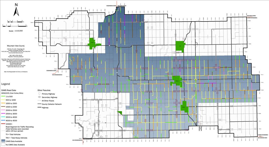
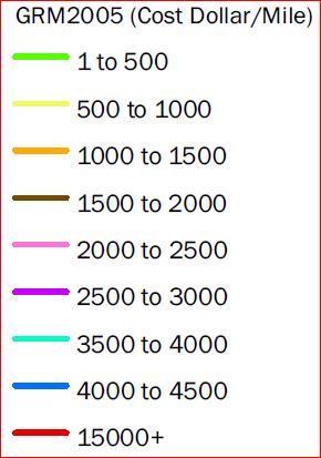
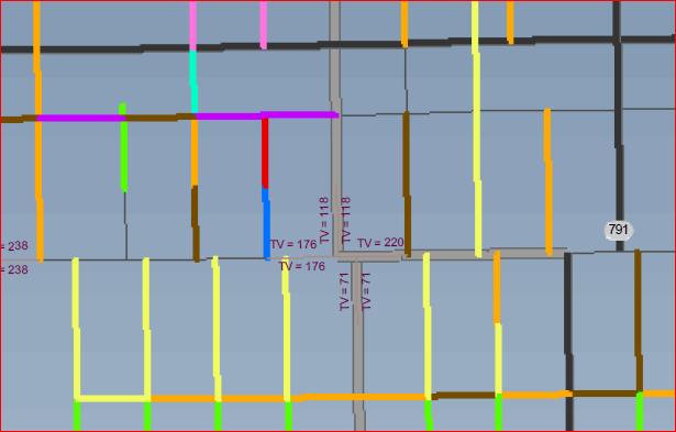
2 2 miles Introduction 1 mile Project Background 2009 Tangible Capital Assets Project 3 phases Road Segment ID numbers Cityworks software County Asset Management System (CAMS) Historical road maintenance costs Pilot study 2005 costs Bellamy financial system Traffic counter data
3 Project Definition Objectives Historical gravel road maintenance costs for 2005 Identification of roads with high cost of maintenance To determine if grading priorities are viable To determine the value of integrating data for 2005 Is it viable to do for other years? To determine the sustainability of costs using historical data as a benchmark
4 Project Definition Stakeholders Key Stakeholder Client Corporate Sponsor Project Supervisor Project Team Name Pete Waycott, Manager Infrastructure Maintenance Don Oldridge, Manager Business Services/IT Therese Morris, GIS Coordinator Therese Morris GIS Coordinator Shirley Gillrie, Corporate Services Business Analyst Bellamy System Pramod Mishra GIS Technician Nancy Green Database Coordinator
5 Project Definition Assumptions County staff availability Stakeholder availability Data compliance with MVC GIS standards All gravel road maintenance costing will be included (manpower, equipment, fuel)
6 Project Definition Constraints Constraints Staff availability Data interoperability Volume of CAMS data GIS software
7 Project Definition In Scope Data acquisition GIS data scrubbing Database Development Data Integration GIS model GIS data analysis Cost effectiveness of project
8 Project Definition Not In Scope What is deemed excessive Effectiveness of grading priorities Sustainability of costs Deciding which roads have underlying issues
9 Project Definition Deliverables Database to support CityWorks Hard copy and soft copy maps showing cost per mile for 2005 Data to support map creation Documentation of process Staff training use/limitations of the data
10 Project Definition Risk Risk Risks Likelihood (1-10) Impact (1-10) No financial data CAMS data cannot be integrated GIS data cannot be integrated GIS Analysis model cannot be used GIS Analysis cannot be done Cost effectiveness cannot be determined Significance L x I
11 Project Definition Approach Initial meeting with key people Data review to find commonalities Database design Data integration and analysis Calculations to determine costs Project Documentation Map production Final Project acceptance by client
12 Project Definition Human Resources Therese Morris GIS Coordinator and Project Manager Shirley Gillrie Corporate Services Business Analyst Bellamy Pramod Mishra GIS Technician Nancy Green Database Coordinator

13 Project Definition Schedule Task/Activity List Predecessors and Duration Estimates for tasks Intermediate/Final Dates including milestones External Constraints Gantt Time Scale
14 Project Definition Cost Labour Costs by task Summary Cost Estimates Resource Item Unit Cost/Unit Units Required Total Cost by Item Actual Costs By Item Labour Therese Hour $ $7, $3, Shirley Hour $ $ $24.21 Pramod Hour $ $1, $ Nancy Hour $ $ $0 Total Project Cost $9, $4,098.44
15 Project Approval Key Stakeholder Client Corporate Sponsor Project Supervisor Project Team Name Pete Waycott, Manager Infrastructure Maintenance Don Oldridge, Manager Business Services/IT Therese Morris, GIS Coordinator Therese Morris GIS Coordinator Shirley Gillrie, Corporate Services Business Analyst Bellamy System Pramod Mishra GIS Technician Nancy Green Database Coordinator Approval Required Project Charter Project Plan Project Charter Project Plan Project Charter Project Plan Project Phases and Final Deliverables GIS Analysis Financial Data GIS Analysis Database consultant
16 Project Methodology
17 Project Methodology
18 2 miles Project Decisions/Data Issues Resolved Lack Segment_ID CAMS of data common data gaps field choices Duration Distance in coverage fields not populated field how of did data we normalize the data? 1 mile 7 min 12 min 9 min 27 min
19 Conclusions Final Product Data Displayed on Map
20 Conclusions Project Statistics $557,000 for gravel road maintenance in hours of maintenance Majority of maintenance costs are between $1-4,000 Several roads identified with cost of $4,500 One road identified with cost of $15,000
21 Conclusions Recommendations Use methodology developed in this project to process data for subsequent years ( ) Methodology allows for data processing to occur in off hours Reduce by estimated $2,000 for subsequent years
22 Conclusion Phase I and II of the Tangible Capital Asset (TCA) Program complete Phase III of TCA methodology to develop historical data is complete, and viable for developing datasets for subsequent years. Cityworks software Operational Services tool for asset management and financial reporting can be fully supported
23 Conclusion Acknowledgements Shirley Gillrie, Business Analyst Pramod Mishra, Spatial Analyst Don Oldridge, Manager, Business Services/IT Pete Waycott, Manager Infrastructure Services All other County staff that provided support to this project
24 Mountain View County Gravel Road Maintenance Costs 2005 Therese Morris GIS Coordinator March 1, 2012
Project Plan for the City of Philadelphia Pole and Pole Attachment Geodatabase Design Project
 Project Plan for the City of Philadelphia Pole and Pole Attachment Geodatabase Design Project Project Overview: The City of Philadelphia is experiencing data integrity problems caused by data format issues.
GIS Geographical Information Systems. GIS Management
 GIS Geographical Information Systems GIS Management Difficulties on establishing a GIS Funding GIS Determining Project Standards Data Gathering Map Development Recruiting GIS Professionals Educating Staff
The Road to Improving your GIS Data. An ebook by Geo-Comm, Inc.
 The Road to Improving your GIS Data An ebook by Geo-Comm, Inc. An individual observes another person that appears to be in need of emergency assistance and makes the decision to place a call to 9-1-1.
LRS Task Force June 13, REVISION HISTORY
 North Carolina Department of Transportation Geographic Information Systems (GIS) Unit LINEAR REFERENCING SYSTEM (LRS) PROJECT DEFINITION Version 1.0 REVISION HISTORY Date Document Manager Revision Purpose
GIS TECHNICIAN I GIS TECHNICIAN II
 GIS TECHNICIAN I GIS TECHNICIAN II CITY OF ROSEVILLE DEFINITION To perform a variety of technical office and field work duties related to the creation and maintenance of maps, tables, graphs and other
Project Charter. $58,000 See attached budget report. shapefile to track poles and pole attachments. Poles are defined as a support structure on
 Project Charter Title: Pole and Pole Attachment Geodatabase Design Sponsor: City of Philadelphia Streets Department Date: May 10, 2006 Estimated Start Date: June 1, 2006 Projected Finish Date: October
Ministry of Health and Long-Term Care Geographic Information System (GIS) Strategy An Overview of the Strategy Implementation Plan November 2009
 Strategy An Overview of the Strategy Implementation Plan November 2009") Ministry of Health and Long-Term Care Geographic Information System (GIS) Strategy An Overview of the Strategy Implementation Plan November 2009 John Hill, Health Analytics Branch Health System Information
Ministry of Health and Long-Term Care Geographic Information System (GIS) Strategy An Overview of the Strategy Implementation Plan November 2009 John Hill, Health Analytics Branch Health System Information
2006 GIS-T T Symposium Columbus Ohio
 2006 GIS-T T Symposium Columbus Ohio Creating a Location Based Response System Using ESRI Technology Brian Stevens, CP Woolpert, Inc. Agenda Introduction What is LBRS? History Specifications Proposed Method
Asset Management Planning. GIS and Asset Management Integration Readiness Assessment
 Asset Management Planning GIS and Asset Management Integration Readiness Assessment With too little data, you won t be able to make any conclusions that you trust. With loads of data you will find relationships
Sample Header for slide
 Sample Header for slide Consultants in Geology and Engineering North Rim Strategic Sourcing Tabetha Stirrett, P. Geo. October 22, 2014 Outline Exploration Phases in the mining industry How North Rim is
KING GEORGE COUNTY DEPARTMENT OF COMMUNITY DEVELOPMENT
 GIS REPORT 2017 KING GEORGE COUNTY DEPARTMENT OF COMMUNITY DEVELOPMENT Background The GIS (Geographic Information System) manager was hired in 2001 to develop a GIS for King George County. Prior to 2001,
Information System Design IT60105
 Information System Design IT60105 Lecture 19 Project Planning Lecture #19 ISD Project Planning SPMP Documentation System Design Models 2 Why Planning Information System Design? Program vs. Software Size
Oregon Department of Transportation. Geographic Information Systems. Implementation Plan. Adopted November, 2000 By the GIS Steering Committee
 Oregon Department of Transportation Geographic Information Systems Implementation Plan Adopted November, 2000 By the GIS Steering Committee Introduction The Oregon Department of Transportation (ODOT) GIS
CITY OF HAMILTON. PUBLIC WORKS DEPARTMENT Operations Division
 CITY OF HAMILTON PUBLIC WORKS DEPARTMENT Operations Division TO: Chair and Members Public Works Committee WARD(S) AFFECTED: CITY WIDE COMMITTEE DATE: December 2, 2013 SUBJECT/REPORT NO: Winter Control
RETA 6422: Mainstreaming Environment for Poverty Reduction Category 2 Subproject
 RETA 6422: Mainstreaming Environment for Poverty Reduction Category 2 Subproject A. Basic Data 1. Subproject Title: Poverty-Environment Mapping to Support Decision Making 2. Country Director: Adrian Ruthenberg
ArcGIS for Local Government
 Wednesday, June 29th ArcGIS for Local Government Dan Rose, GIS Analyst WaterOne IT/GIS Agenda / Talking Points What is the LGIM? WaterOne s GIS and LGIM background Our geodatabase redesign Our strategies
JOB TITLE: CURRENT CLASSIFICATION/GRID POSITION # GIS Coordinator AD Grid Level 6(c) # 420
 # 420") COUNTY OF GRANDE PRAIRIE JOB DESCRIPTION JOB TITLE: CURRENT CLASSIFICATION/GRID POSITION # GIS Coordinator AD Grid Level 6(c) # 420 NOC CODE: 2255 STANDARD HOURS: 35 hours/week (non-management) JOB TITLE
COUNTY OF GRANDE PRAIRIE JOB DESCRIPTION JOB TITLE: CURRENT CLASSIFICATION/GRID POSITION # GIS Coordinator AD Grid Level 6(c) # 420 NOC CODE: 2255 STANDARD HOURS: 35 hours/week (non-management) JOB TITLE
KING GEORGE COUNTY DEPARTMENT OF COMMUNITY DEVELOPMENT
 GIS REPORT 2016 KING GEORGE COUNTY DEPARTMENT OF COMMUNITY DEVELOPMENT Background The GIS (Geographic Information System) coordinator was hired in 2001 to develop a GIS for King George County. Prior to
Building GIS for Fairfax County Wastewater Management. Gilbert Osei-Kwadwo
 Abstract: Building GIS for Fairfax County Wastewater Management Gilbert Osei-Kwadwo Wastewater Management Agency (WWM) of Fairfax County in Virginia has put a lot of efforts into building an effective
Cost-Benefit Analysis of the Pooled- Fund Maintenance Decision Support System: Case Study
 Cost-Benefit Analysis of the Pooled- Fund Maintenance Decision Support System: Case Study Zhirui Ye (WTI) Xianming Shi (WTI) Christopher K. Strong (City of Oshkosh) 12 th AASHTO-TRB TRB Maintenance Management
Ready to Respond: Improving Critical Water Line Locating with SUE and GIS
 Ready to Respond: Improving Critical Water Line Locating with SUE and GIS Matt Wetherell Town of Cary Eric Wilson KCI Technologies Shane Slaughter KCI Technologies Discussion Background Kildaire Farm Rd
A Summary of State DOT GIS Activities. Presented at the 2004 AASHTO GIS-T Symposium Rapid City, SD
 A Summary of State DOT GIS Activities Presented at the 2004 AASHTO GIS-T Symposium Rapid City, SD Information Sources E-mail survey of state DOT GIS managers All 51 State DOTs (and DC) responded in 2004
GEOMATICS SURVEYING AND MAPPING EXPERTS FOR OVER 35 YEARS
 GEOMATICS SURVEYING AND MAPPING EXPERTS FOR OVER 35 YEARS 2 GEOMATICS AND SURVEYING SOLUTIONS SPANNING THE ENTIRE PROJECT LIFECYCLE 1,000+ 250+ 24 Surveying professionals Active field crews Geomatics offices
2007 / 2008 GeoNOVA Secretariat Annual Report
 2007 / 2008 GeoNOVA Secretariat Annual Report Prepared for: Assistant Deputy Minister and Deputy Minister of Service Nova Scotia and Municipal Relations BACKGROUND This report reflects GeoNOVA s ongoing
Mermaid. The most sophisticated marine operations planning software available.
 Mermaid The most sophisticated marine operations planning software available. Mojo Maritime / Marine economic risk management aid Mermaid : marine economic risk management aid The most sophisticated marine
Terms of Reference for the Comparative Environmental Review (CER) of. Options for the Mactaquac Project, Mactaquac, New Brunswick
 of. Options for the Mactaquac Project, Mactaquac, New Brunswick") Terms of Reference for the Comparative Environmental Review (CER) of Options for the Mactaquac Project, Mactaquac, New Brunswick Preamble The New Brunswick Power Corporation ( NB Power ) operates the Mactaquac
Terms of Reference for the Comparative Environmental Review (CER) of Options for the Mactaquac Project, Mactaquac, New Brunswick Preamble The New Brunswick Power Corporation ( NB Power ) operates the Mactaquac
Road Ahead: Linear Referencing and UPDM
 Road Ahead: Linear Referencing and UPDM Esri European Petroleum GIS Conference November 7, 2014 Congress Centre, London Your Work Making a Difference ArcGIS Is Evolving Your GIS Is Becoming Part of an
Linear Referencing in Boulder County, CO. Getting Started
 Linear Referencing in Boulder County, CO Getting Started 1 Authors Janie Pierre GIS Technician, Boulder County Road centerline and storm sewer geodatabases & maps John Mosher GIS Specialist, Boulder County
To: Ross Martin, Lisa Stapleton From: Brad Lind Subject: Joint Funding Agreement with USGS for 2012 Imagery Date: March 14, 2012.
 To: Ross Martin, Lisa Stapleton From: Brad Lind Subject: Joint Funding Agreement with USGS for 2012 Imagery Date: March 14, 2012 Attached are two copies of the Joint Funding Agreement (JFA) between SanGIS
GIS FOR MAZOWSZE REGION - GENERAL OUTLINE
 GIS FOR MAZOWSZE REGION - GENERAL OUTLINE S. Bialousz 1), K Mączewski 2), E. Janczar 2), K. Osinska-Skotak 1) 1) Warsaw University of Technology, Warsaw, Poland 2) Office of the Surveyor of the Mazowieckie
A Summary of State DOT GIS Activities. Presented at the 2000 AASHTO GIS-T Symposium Minneapolis, MN
 A Summary of State DOT GIS Activities Presented at the 2000 AASHTO GIS-T Symposium Minneapolis, MN Information Sources E-mail survey of state DOT GIS managers 49 State DOTs responded in 2000 Results compared
RESOLUTION NOW, THEREFORE, BE IT RESOLVED BY THE BOARD OF SUPERVISORS OF THE CORKSCREW FARMS COMMUNITY DEVELOPMENT DISTRICT:
 RESOLUTION 2017-08 A RESOLUTION OF THE BOARD OF SUPERVISORS OF THE CORKSCREW FARMS COMMUNITY DEVELOPMENT DISTRICT APPROVING PROPOSED BUDGET(S) FOR FISCAL YEAR 2017/2018 AND SETTING A PUBLIC HEARING THEREON
Building an Enterprise GIS for Chicago s Water Reclamation District
 Building an Enterprise GIS for Chicago s Water Reclamation District Presenters Presented at the 2010 ESRI User Conference Authored and Presented By Sanjay Patel, PE, CEM, CMRP Metropolitan Water Reclamation
King County GIS Center 2018 Esri User Conference San Diego, California July 12, 2018
 Greg Babinski, MA, GISP Marketing & Business Development Manager URISA Past-President King County GIS Center 2018 Esri User Conference San Diego, California July 12, 2018 Geography has always been a major
Steve Pietersen Office Telephone No
 Steve Pietersen Steve.Pieterson@durban.gov.za Office Telephone No. 031 311 8655 Overview Why geography matters The power of GIS EWS GIS water stats EWS GIS sanitation stats How to build a GIS system EWS
Decision-making support tool for promotion policies of abandoned mine areas
 2013 Esri International User Conference July 8 12, 2013 San Diego, California Decision-making support tool for promotion policies of abandoned mine areas Son, Jin Seoul National University Esri UC2013.
SECTION DESCRIPTION PAGE I. BUDGET INTRODUCTION... 1 II. FISCAL YEAR 2017 BUDGET ANALYSIS... 2 III. PROPOSED OPERATING BUDGET... 3
 2018 SECTION DESCRIPTION PAGE I. BUDGET INTRODUCTION... 1 II. FISCAL YEAR 2017 BUDGET ANALYSIS... 2 III. PROPOSED OPERATING BUDGET... 3 IV. GENERAL FUND 001 DESCRIPTIONS... 4 V. DEBT SERVICE FUNDS... 6
GIS Implementation part 2. Implementation challenges Key issues Effect Consequences
 GIS Implementation part 2 Implementation challenges Key issues Effect Consequences GIS management The first aspect of understanding and successfully accomplishing GIS implementation and management is to
Oakland County Parks and Recreation GIS Implementation Plan
 Oakland County Parks and Recreation GIS Implementation Plan TABLE OF CONTENTS 1.0 Introduction... 3 1.1 What is GIS? 1.2 Purpose 1.3 Background 2.0 Software... 4 2.1 ArcGIS Desktop 2.2 ArcGIS Explorer
Geological information for Europe : Towards a pan-european Geological Data Infrastructure
 Geological information for Europe : Towards a pan-european Geological Data Infrastructure Integrating geoscientific information for EU competitiveness Co-funded by the European Union European societal
Enabling Success in Enterprise Asset Management: Case Study for Developing and Integrating GIS with CMMS for a Large WWTP
 Enabling Success in Enterprise Asset Management: Case Study for Developing and Integrating GIS with CMMS for a Large WWTP Allison Blake, P.E. 1*, Matthew Jalbert, P.E. 2, Julia J. Hunt, P.E. 2, Mazen Kawasmi,
Geohazard risk assessment and asset management along railway corridors
 Geohazard risk assessment and asset management along railway corridors BGC: Matt Lato, Pete Quinn, Mark Pritchard, Mike Porter and Sarah Newton IOC: Dominique Sirois BGC supports risk-based geohazard management
Information. Information Technology. Geographic. Services (GIS) 119 W Indiana Ave Deland, FL 32720
 119 W Indiana Ave Deland, FL 32720") Information Technology Geographic Information Services (GIS) 119 W Indiana Ave Deland, FL 32720 A GIS consists of 5 primary components: Hardware Software People Data Methods or Business Processes --- Hardware
Information Technology Geographic Information Services (GIS) 119 W Indiana Ave Deland, FL 32720 A GIS consists of 5 primary components: Hardware Software People Data Methods or Business Processes --- Hardware
Desktop GIS for Geotechnical Engineering
 Desktop GIS for Geotechnical Engineering Satya Priya Deputy General Manager (Software) RMSI, A-7, Sector 16 NOIDA 201 301, UP, INDIA Tel: +91-120-2511102 Fax: +91-120-2510963 Email: Satya.Priya@rmsi.com
Large Scale Mapping Policy for the Province of Nova Scotia
 Large Scale Mapping Policy for the Province of Nova Scotia December, 2005 Version 1.0 TABLE OF CONTENTS PAGE BACKGROUND...3 POLICY...5 Policy 1.0 Large Scale Mapping Program...5 Policy 2.0 Service Offering...5
Creating a Pavement Management System Using GIS
 Christopher Castruita PPD 631 Prof. Barry Waite & Prof. Bonnie Shrewsbury Creating a Pavement Management System Using GIS Problem Definition As is the case with many cities, the city of La Cañada Flintridge
SRH Group Facies Mapping
 Study 37 SRH Group Facies Mapping Public Draft 2014 Monitoring and Analysis Plan September 2013 Project Management Plan (PMP) Job Name: San Joaquin River Restoration Program Date Submitted: 8-1-13 Hydraulic
FIRE DEPARMENT SANTA CLARA COUNTY
 DEFINITION FIRE DEPARMENT SANTA CLARA COUNTY GEOGRAPHIC INFORMATION SYSTEM (GIS) ANALYST Under the direction of the Information Technology Officer, the GIS Analyst provides geo-spatial strategic planning,
NC Streambed Mapping Project Issue Paper
 ISSUE 1: The Western North Carolina Drainage Area Requirement Issue Several inquiries and discussions in regard to the determination of the 6-acre drainage area requirement as the upstream limit have been
Department Mission: Mandated Services: Department Overview: Successes and Challenges:
 Department: Information Technology FY 2019 Proposed Budget Department Mission: Klamath County Information Technology delivers business services that empower, support and serve all county departments in
7 GEOMATICS BUSINESS SOLUTIONS - ANNUAL REPORT 2006
 7 GEOMATICS BUSINESS SOLUTIONS - ANNUAL REPORT 2006 The Planning and Economic Development Committee recommends the adoption of the recommendation contained in the following report November 30, 2006, from
GIS ADMINISTRATOR / WEB DEVELOPER EVANSVILLE-VANDERBURGH COUNTY AREA PLAN COMMISSION
 GIS ADMINISTRATOR / WEB DEVELOPER EVANSVILLE-VANDERBURGH COUNTY AREA PLAN COMMISSION SALARY RANGE INITIATION $43,277 SIX MONTHS $45,367 POSITION GRADE PAT VI The Evansville-Vanderburgh County Area Plan
Council Roadside Reserves Environmental Grants
 Roadside Reserves Environmental Grants The Roadside Reserves (CRR) project is a three year project funded by the NSW Environmental Trust and managed by Local Government NSW to help councils towards best
GIS Capability Maturity Assessment: How is Your Organization Doing?
 GIS Capability Maturity Assessment: How is Your Organization Doing? Presented by: Bill Johnstone Principal Consultant Spatial Vision Group November 8, 2018 1. Motivation for Capability Maturity Models
2018 Project Prioritization and Budgeting Process
 2018 Prioritization and Budgeting Process Brian Hurysz Manager, Market Products Budget and Priorities Working Group August 18, 2017, Krey Corporate Center Agenda 2018 Prioritization Process Prioritization
Agenda. Johnson County. Introduction What Is GIS? Needs Assessment Strategic Plan GIS Task force What do we need from you?
 Agenda Introduction What Is GIS? Needs Assessment Strategic Plan GIS Task force What do we need from you? Open Forum 1 Introduction Michael Sudac GIS Director 13 years GIS experience GIS Supervisor for
CHAPTER 22 GEOGRAPHIC INFORMATION SYSTEMS
 CHAPTER 22 GEOGRAPHIC INFORMATION SYSTEMS PURPOSE: This chapter establishes the administration and use of to improve the quality and accessibility of Department s spatial information and support graphical
Community and Infrastructure Services Committee
 REPORT TO: DATE OF MEETING: November 7, 2016 Community and Infrastructure Services Committee SUBMITTED BY: Cynthia Fletcher, Interim Executive Director INS 519-741- PREPARED BY: WARD(S) INVOLVED: 2600
Land Use Methods & Metrics Development Outcome
 Quarterly Progress Meeting November 15, 2018 Land Use Methods & Metrics Development Outcome Peter Claggett, USGS LUWG Coordinator Through the Chesapeake Bay Watershed Agreement, the Chesapeake Bay Program
file://q:\report1\greenatlasfinalreportindex.html
 Page 1 of 8 Quick Links WATER MANAGEMENT INTERNSHIP USDA HIS GRANT FUNDED FINAL PROJECT REPORT SUBMITTED BY MELISSA QUINTANA 11/07/07-03/24/08 Summary Provided is an assessment of my accomplishments for
Seq No: 8 ARCHIVED on 21-May-2018 ISR30720 Created by: Raghava Neti on 04-Dec-2017 Modified by: Raghava Neti on 08-May-2018
 Public Disclosure Authorized SOUTH ASIA India Water Global Practice Requesting Unit: SACIN Responsible Unit: GWA06 IBRD/IDA Program-for-Results FY 2014 Team Leader(s): Raghava Neti Seq No: 8 ARCHIVED on
BUILDING AN ASSET MANAGEMENT GEODATABASE FOR RANCHING. Matt Crawford, GISP
 BUILDING AN ASSET MANAGEMENT GEODATABASE FOR RANCHING Matt Crawford, GISP Introduction East Foundation Formed in 2007 Mission Research Education Outreach Properties Six ranches ~ 215,000 acres San Antonio
SECONDARY ROADS LEVERAGING ENTERPRISE GIS. Secondary Road Department & GIS Department Linn County, Iowa April 20, 2015
 SECONDARY ROADS LEVERAGING ENTERPRISE GIS Secondary Road Department & GIS Department Linn County, Iowa April 20, 2015 Brad Ketels, P.E. Linn County Assistant Engineer Matt Boyle, GISP Linn County GIS Analyst
GIS and the Other Enterprise Database
 GIS-T T Symposium GIS and the Other Enterprise Database March 31, 2004 Rapid City, South Dakota 1 Introduction Personal thoughts on recent evolution of GIS Shift in perspective from GIScentric to asset-centric
Improvement of the National Hydrography Dataset for US Forest Service Region 3 in Cooperation with the National Forest Service
 Improvement of the National Hydrography Dataset for US Forest Service Region 3 in Cooperation with the National Forest Service Christian L. DeCasas California State University, Northridge November 7 th,
Public Disclosure Copy. Implementation Status & Results Report CN Yunnan Honghe Prefecture Diannan Center Urban Transport (P101525)
") Public Disclosure Authorized EAST ASIA AND PACIFIC China Transport & ICT Global Practice IBRD/IDA Investment Project Financing FY 2014 Seq No: 4 ARCHIVED on 11-Dec-2015 ISR21753 Implementing Agencies:
Public Disclosure Authorized EAST ASIA AND PACIFIC China Transport & ICT Global Practice IBRD/IDA Investment Project Financing FY 2014 Seq No: 4 ARCHIVED on 11-Dec-2015 ISR21753 Implementing Agencies:
Appendix C Benchmarking Cost Estimates
 REPORT Appendix C Benchmarking Cost Estimates C-1 Table C-1 Permits, Notifications & Location Services Notes: Costs associated with delays in construction have not been included in this estimate OneCall
Imagery and the Location-enabled Platform in State and Local Government
 Imagery and the Location-enabled Platform in State and Local Government Fred Limp, Director, CAST Jim Farley, Vice President, Leica Geosystems Oracle Spatial Users Group Denver, March 10, 2005 TM TM Discussion
Bringing GIS to the Front Lines Author- Mike Masters Co-Author James Kelt
 Pearland, Texas and Enterprise Wide GIS Bringing GIS to the Front Lines Author- Mike Masters Co-Author James Kelt Presenters Mike Masters- GIS Coordinator The City of Pearland, Texas Richard DeLa Mater-
MAPPS 2012 Geospatial Products and Services Excellence Awards Awards Entry Form
 MAPPS 2012 Geospatial Products and Services Excellence Awards 2012 Awards Entry Form Please include a copy of this document with the project/product submission Entry Information Submission Number: 1741558
THE ROLE OF GEOSPATIAL AT THE WORLD BANK
 THE ROLE OF GEOSPATIAL AT THE WORLD BANK INSPIRE Conference Barcelona, Spain September 26, 2016 Kathrine Kelm Senior Land Administration Specialist Global Land and Geospatial Unit The World Bank Group
Country Report on SDI Activities in Singapore *
 UNITED NATIONS E/CONF.100/CRP.9 ECONOMIC AND SOCIAL COUNCIL Eighteenth United Nations Regional Cartographic Conference for Asia and the Pacific Bangkok, 26-29 October 2009 Item 7(a) of the provisional
Services.
 1 Transport Analysis & Modeling Over the course of a decade, Masterconcept has gained a wide range of experience in the field of transport master planning, with a special emphasis on regional and urban
31 Dec '01 07 Jan '02 14 Jan '02 21 Jan '02 28 Jan '02 M T W T F S S M T W T F S S M T W T F S S M T W T F S S M T W T F S S
 ID Task Name Duration 0 7 Month Project Plan Template 158.5 days 1 1 Preproduction 81.5 days 2 1.1 Project Clarification 12.5 days 3 1.1.1 Clarify/Audit Commercial (inc. Marketing) requirements/objectives
The inland water related tourism in South Africa by 2030 in the light of global change
 The inland water related tourism in South Africa by 2030 in the light of global change KSA 2 Water-Linked Ecosystems T4: Green economy and sustainable (green) innovations K5/2620 How can natural capital
Introduction and Project Overview
 Greater New Orleans Regional Land Use Modeling GIS Techniques in a P olitical C ontext Louisiana Remote Sensing and GIS Workshop Wednesday, April 24, 2013 Working Towards a Shared Regional Vision Introduction
Educational Qualification No ( No of Positions) 01. Geographic
 01. Geographic") ICZMP, State Project Management Unit-Orissa Plot # 108,Unit VII, Suryanagar,Bhubaneswar 751 003 ICZMP invites applications from eligible candidates for filling up of posts as mentioned below under the
ICZMP, State Project Management Unit-Orissa Plot # 108,Unit VII, Suryanagar,Bhubaneswar 751 003 ICZMP invites applications from eligible candidates for filling up of posts as mentioned below under the
Surveyors and GIS Geeks What we need to know. Alyssa Martin, GISP, LEED BD+C AP, Nathan Wysocki
 Surveyors and GIS Geeks What we need to know Alyssa Martin, GISP, LEED BD+C AP, Nathan Wysocki Adversarial Relationship? Some sources Tension between surveying and GIS: A growing challenge Connecting the
SECTION DESCRIPTION PAGE I. BUDGET INTRODUCTION... 1 II. FISCAL YEAR 2016 BUDGET ANALYSIS... 2 III. FINAL OPERATING BUDGET FUND
 2017 SECTION DESCRIPTION PAGE I. BUDGET INTRODUCTION... 1 II. FISCAL YEAR 2016 BUDGET ANALYSIS... 2 III. FINAL OPERATING BUDGET FUND 001... 3 IV. GENERAL FUND 001 DESCRIPTIONS... 4 V. DEBT SERVICE FUND...
Utilizing GIS Technology for Rockland County. Rockland County Planning Department Douglas Schuetz & Scott Lounsbury
 Utilizing GIS Technology for Rockland County Rockland County Planning Department Douglas Schuetz & Scott Lounsbury Presentation Agenda Introduction What is GIS What can GIS do GIS Efforts for BOE Resources
Implementing ArcGis 10 infrastructure to resolve mining problems
 Implementing ArcGis 10 infrastructure to resolve mining problems ESRI UC 2013, San Diego, 8-12 July, 2013 A R T U R O M O R A L E S L A D R O N D E G U E V A R A, E L T E N I E N T E M I N E, C O D E L
Selection of the Most Suitable Locations for Telecommunication Services in Khartoum
 City and Regional Planning Term Project Final Report Selection of the Most Suitable Locations for Telecommunication Services in Khartoum By Amir Abdelrazig Merghani (ID:g201004180) and Faisal Mukhtar (ID:
Case study: Nairobi City County CBD and its Environs. Presenter: Peter Patrick Kioko. Supervisor: Mr. B.M. Okumu
 Case study: Nairobi City County CBD and its Environs Presenter: Peter Patrick Kioko Supervisor: Mr. B.M. Okumu OUTLINE Introduction Problem Statement Objectives Area of study Application of GIS Methodology
GEOGRAPHIC INFORMATION SYSTEMS Session 8
 GEOGRAPHIC INFORMATION SYSTEMS Session 8 Introduction Geography underpins all activities associated with a census Census geography is essential to plan and manage fieldwork as well as to report results
Internal Audit Report
 Internal Audit Report Right of Way Mapping TxDOT Internal Audit Division Objective To determine the efficiency and effectiveness of district mapping procedures. Opinion Based on the audit scope areas reviewed,
How to Increase the Significance of your GIS
 How to Increase the Significance of your GIS Wade Kloos, GIS Director, Utah Department of Natural Resources wkloos@utah.gov 2014 Esri International User Conference July 17 How to Increase the Significance
15 March 2010 Re: Draft Native Vegetation of the Sydney Metropolitan Catchment Management Authority Area GIS layers and explanatory reports
 SYDNEY COASTAL COUNCILS GROUP Inc. C/- City of Sydney Council Level 14, 456 Kent Street GPO Box 1591, SYDNEY NSW 2001 Phone: (02) 9246 7791 Facsimile: (02) 9265 9660 Email: info@sydneycoastalcouncils.com.au
MISSOURI LiDAR Stakeholders Meeting
 MISSOURI LiDAR Stakeholders Meeting East-West Gateway June 18, 2010 Tim Haithcoat Missouri GIO Enhanced Elevation Data What s different about it? Business requirements are changing.fast New data collection
Professional Agreement Invoice and Progress Report
 ITD 0771 (Rev. 10-06) itd.idaho.gov Professional Agreement Invoice and Progress Report Idaho Transportation Department This page must be filled out monthly by the Consultant and forwarded to the Agreement
TRAITS to put you on the map
 TRAITS to put you on the map Know what s where See the big picture Connect the dots Get it right Use where to say WOW Look around Spread the word Make it yours Finding your way Location is associated with
Linear Referencing Systems (LRS) Support for Municipal Asset Management Systems
 Support for Municipal Asset Management Systems") Linear Referencing Systems (LRS) Support for Municipal Asset Management Systems Esri Canada Infrastructure Asset Management Leadership Forum November 1, 2017 Toronto, ON David Loukes, P. Eng., FEC Andy
Linear Referencing Systems (LRS) Support for Municipal Asset Management Systems Esri Canada Infrastructure Asset Management Leadership Forum November 1, 2017 Toronto, ON David Loukes, P. Eng., FEC Andy
GIS Co-operative Project Final Report Figure 33.0 Screenshot of Map 141A Dorset-Eagle Lake
 Figure 33.0 Screenshot of Map 141A Dorset-Eagle Lake 35 (2.6) Methodology Overview The following flow-chart is a breakdown of the methodology beginning with the data pre-processing stage. Figure 34.0 Methodology
EMMA : ECDC Mapping and Multilayer Analysis A GIS enterprise solution to EU agency. Sharing experience and learning from the others
 EMMA : ECDC Mapping and Multilayer Analysis A GIS enterprise solution to EU agency. Sharing experience and learning from the others Lorenzo De Simone, GIS Expert/ EMMA Project Manager 2014 GIS Workshop,
gvsig: Open Source Solutions in spatial technologies
 gvsig: Open Source Solutions in spatial technologies gvsig is a tool for handling geographical information, a completely GIS client with license GNU GPL. Alvaro A. Anguix Alfaro, Gabriel Carrión Rico Conselleria
Using ROI Methodology to Measures the Benefits of King County GIS
 Using ROI Methodology to Measures the Benefits of King County GIS 2012 Washington GIS Conference Tacoma, Washington May 9, 2012 Greg Babinski, MA, GISP Finance & Marketing Manager King County GIS Center
Climate Change Engineering Vulnerability Assessment. Coquihalla Highway (B.C. Highway 5) Between Nicolum River and Dry Gulch
 Between Nicolum River and Dry Gulch") SSuum mm maarryy ffoorr PPoolliiccyy M Maakkeerrss Climate Change Engineering Vulnerability Assessment Rev 2 June 2, 2010 Rev 2 June 2, 2010 Page 2 of 7 1 Conclusion 1.1 Adaptive Management Process BCMoTI
SSuum mm maarryy ffoorr PPoolliiccyy M Maakkeerrss Climate Change Engineering Vulnerability Assessment Rev 2 June 2, 2010 Rev 2 June 2, 2010 Page 2 of 7 1 Conclusion 1.1 Adaptive Management Process BCMoTI
ANYTIME PDUs: COMBO PACK 4 (62 PDUs) No Longer Available PLAN SUMMARY TAKE COURSES ONLINE 24/7** Purchase Option
 No Longer Available PLAN SUMMARY TAKE COURSES ONLINE 24/7** Purchase Option") ANYTIME PDUs: COMBO PACK 4 (62 PDUs) Purchase Option No Longer Available PLAN SUMMARY The Anytime PDUs: Combo Pack #4 online training subscription plan includes 50 online courses that award a varying number
ANYTIME PDUs: COMBO PACK 4 (62 PDUs) Purchase Option No Longer Available PLAN SUMMARY The Anytime PDUs: Combo Pack #4 online training subscription plan includes 50 online courses that award a varying number
NCAVES - Global initiative and national pilots
 NCAVES - Global initiative and national pilots Kavita Sharma UN Environment Pretoria, March 2018 Outline 1. Global initiative > Introduction > Objectives and deliverables >Activities in 2017 and 2018 2.
MODERNIZATION OF THE MUNICIPAL MAPPING USING HIGH END GNSS SYSTEM AND GIS SOFTWARE
 MODERNIZATION OF THE MUNICIPAL MAPPING USING HIGH END GNSS SYSTEM AND GIS SOFTWARE Mr. R. A. R. Khan Assistant Engineer, Sewerage Utility Management Centre (SUMC) Municipal Corporation Of Greater Mumbai
COPYRIGHTED MATERIAL. 1 Introduction
 1 Introduction GIS technology has been used in a variety of government and semi-government organisations since the late 1970s. However it has only been in the last two decades that GIS has become a technology