How Every Library Can Use Web GIS
|
|
|
- Clifford Nichols
- 5 years ago
- Views:
Transcription
1 How Every Library Can Use Web GIS Eva Dodsworth Geospatial Data Services Librarian University of Waterloo Library Courtney Lundrigan Librarian Intern/MLIS Candidate Ryerson University Library/University of Western Ontario
2 Why are we here today? Upgrading Skills to Include Web Mapping 2.0 Technology GIS technology is all around us. Library users are using it. It s time for library staff to use it too An introduction to Web GIS Resources Introduction to Visual/Spatial Literacy How are Library Staff using GIS? The importance of GIS training for library staff
3 Web 2.0 and Social Networking Technology Libraries are using social networking technology to connect with students Curtis Rogers (2009) conducted a survey of American library staff members to determine the variety of Web 2.0 and social networking sites utilized to promote library services and programs. Among the highest ranked were Facebook (71.4%), Flickr (49.6%), and Blogs (47.4%), followed by Twitter and Meebo (36.1%) and YouTube (35.3%). The survey did not include mapping based Web 2.0 applications, which was found to be a common omission among surveys studied. Facebook : 400 million users Flicker : 27 million users Twitter : 105 million users YouTube : 258 million users Google Earth : Over 600 million users Google Maps : Even more!
4 Are Libraries Using Mapping Products? Eva Dodsworth and Andrew Nicholson, 2011, Google Earth Usage in Academic Libraries survey, (January, 2011, unpublished). -Over 80 responses, US and Canada - 45% use Google Mapping Products on a weekly bases (27% use them more than 3 times a week) - 82% (58) used these products to answer research questions - 61% (43) used these products for creating or accessing a finding aid tool - 56% (40) for instruction purposes - 27% for promotion/marketing - 20% (14) have used them for project work such as georeferencing imagery, for use in webpages and for training purposes
5 Concepts to think about throughout this session How can these tools be used in your library? Are there opportunities to embed this technology into the course curriculum? Can you utilize this technology to outreach to library users? Can you utilize this technology to promote or deliver library services and resources?
6 Objective Number One: Geographical Awareness GIS is Everywhere!

7 Everyday information is becoming widely presented in map form Traffic Flows

8 fboweb.com Flight Tracker

9

10

11

12 Trans Canada Trail

13

14

15

16

17
18 Web 2.0 and the Neogeographer You don t need to be a professional cartographer to create a map You don t need to be a programmer to create a mapping application Neogeography : Essentially, Neogeography is about people using and creating their own maps, on their own terms and by combining elements of an existing toolset. Andrew Turner, Also known as Citizen Mapping
19 Citizen Mapping Projects Urban Forest Map : Open Street Map : openstreetmap.org

20

21

22

23


24
25 OpenStreetMap vs Google Maps

26 OpenStreetMap

27 Google Maps

28 Search for photos spatially

29 Google Earth 360 photos

30 Our interest in locations is providing much more than a spot on the map : -It has increased our awareness of the world outside our doorstep -It has validated the benefits and ease of sharing information -It has brought communities with same interests together
31 We are interested in locations! Our whereabouts GPS chips Geographical settings of novels, location of news events Location stamping (geo tagging) vacations (Flikr) and events (blogs, Facebook)


32 Visual Literacy Map reading and map writing are lifelong literacy skills. -Know how to communicate with maps -Know that maps exist and where
33 We are expected to have map literacy skills. Read a map Create a map Society is communicating information in a map format To tell a story To find patterns To find solutions To make information clearer
34 Objective Number Two: Geospatial Literacy Skills As library professionals, it is expected that we have developed the visual/mapping literacy skills that our students, faculty and other library users are fluent in Well rehearsed in seeing mapping opportunities to communicate information Able to point students and faculty to the right resources An increase in geographical interest! more faculty are incorporating maps into their courses cross-discipline interests in mapping wider interest in GIS some people want to go beyond online mapping tools wider interest in GIS-related workshops; wider interest in Map Library Services
35 Map Literacy on Campus How are students and faculty using maps and online mapping resources?
36 Google Earth Source for information on land and people Archaeological information Social and cultural information Urban and commercial development Geographical information Natural disasters and restoration Mapping! Simple and advanced Georeferencing photos and maps higher resolution or historical 3 D Model building Sketchup
37 Mapping Tabular Information People are interested in mapping addresses, survey results, and points of interests Quite popular with the social sciences mapping the location of respondents Excellent product Google Fusion allows you to paste your Excel table with address information into the online program and it instantly creates latitude and longitude coordinates for each address in your table. You can then view your address points in Google Earth, Google Maps, or import your updated Excel table into a GIS program for further analysis
38 Creating mashups We often use other people s mashups, but we can all easily create our own! Scribblemaps.com Can scribble, add markers, paths (streets, trails, etc), add tables, add images, add GIS files, add KML! Imbed map into other applications using widgets Google Maps, Bing Maps

39
40
41
42 Interactive Mapping Government resources available freely online Municipal information (neighbourhood level) Provincial/State level projects (Parks, Soil Surveys, Topography) National Level projects (Census)

43 Municipal Mapping City of Ottawa emap :

44 City of Ottawa Interactive Traffic Map

45 Land Information Ontario (LIO)

46
47 Historical Mapping People across several disciplines are interested in studying historical facts about our land Egyptian and Roman design of streets Bends and sizes of rivers and lakes Changes in political boundaries, and in names Rural and Urban Development parcel divisions Historical settings read in books and texts Many online sites offer historical maps for viewing and downloading

48 Accessing static maps A wide variety of scanned maps are available for download Toporama prototype

49 Accessing static maps Geological Survey of Canada :
50 Spatial Data Providers Online maps don t meet the needs of all users Advanced mapping and analysis is often done in desktop GIS programs ArcGIS, MapInfo, Manifold, or several open source programs Data for these programs are often available from the Map Library, as well as from online resources

51 Geographynetwork.ca

52

53

54
55 Open Access to Data City of Toronto Open Data City of Vancouver Open Data City of London Open Data


56
57 If library users are utilizing all of these web mapping resources, shouldn t library staff do the same?
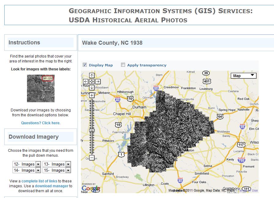
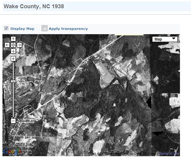
58 How are Library Staff Using Web GIS? Creating maps! Digitizing Library Collections Promoting and Delivering Library Collections Teaching and training students, faculty and other library users Reference services Course liaison responsibilities Administration As a communication and information tool

59 Showing Library Locations

60 University of North Carolina

61 San Diego Public Library

62 St. Paul Public Library BookMobile Locations & Schedule
63 Resource Sharing University of Vermont Library Digitized Photo Collection, Geotagged and make available online ongtrail&title=long%20trail%20photographs Slide 1/2


64 University of Vermont Photograph Collection

65 University of North Carolina Air Photo Collection Slide 1/3
66 Slide 2/3
67 Slide 3/3

68 Digitizing and Georeferencing Fire Insurance Plans


69 University of Waterloo Historical Air Photo Project t/
70 Slide 1/3

71 Slide 2/3


72

73 Slide 1/2


74

75

76 McMillan Memorial Library, Wisconsin Cemetery Locations

77 McMillan Memorial Library : Postcard Collection
78
79 Breaking down the silos GIS is not a subject, but a multi-disciplinary technology Although many libraries still have a GIS librarian or a GIS technician, we should conceptualize GIS as a companion to current library services Virtually every subject area will find use for GIS English, History, Psychology, Health Sciences, etc. GIS has evolved from a subject area to an integral part of research and library activity
80 For Reference Services Many of the enquiries made of libraries and their on-line systems have a geographical question at their core e.g. where is. ; where can I find. are there any. in, who lives at. Street and land maps, voters lists, weather maps, satellite images and environmental information are part of the resource which may be used to answer these enquiries. As more and more geographic and cartographic data goes over to a primarily digital form librarians will have to grasp the nettle of providing GIS and its supporting hardware to the public - workshops, help create maps, insert into reports.
81 The Importance of GIS Training for Library Staff Why learn about GIS?
82 WHY NOT?
 Courtney Lundrigan, August")
83 Population Decline, % ( ) Courtney Lundrigan, August 2010
84 Information to take back to the office Multidisciplinary uses for mapping how can it be used in your disciplines? Familiarity with features of online mapping programs (what can they do?) Google Earth, Google mashups, other online programs An understanding that any information with a geographical component can be mapped (displaying database files) e.g. Survey results, census data Consider working with the GIS librarian to imbed mapping resources into the classrooms/course curriculum
85 References Rogers, Curtis. Social Media, Libraries, and Web 2.0 : How American Libraries are Using New Tools for Public Relations and to Attract new Users. Slideshare. (accessed 18 April, 2010.). Scribd. Social Media 2008 Statistics. (accessed 21 April, 2010). Statsaholic. Website Traffic Graphs for Flikr. (accessed 21 April, 2010). Yahoo News. Twitter has over 105 million registered users : co-founder, Yahoo News, April 14, (accessed 16 April, 2010).
GIS Visualization: A Library s Pursuit Towards Creative and Innovative Research
 GIS Visualization: A Library s Pursuit Towards Creative and Innovative Research Justin B. Sorensen J. Willard Marriott Library University of Utah justin.sorensen@utah.edu Abstract As emerging technologies
Techniques for Science Teachers: Using GIS in Science Classrooms.
 Techniques for Science Teachers: Using GIS in Science Classrooms. After ESRI, 2008 GIS A Geographic Information System A collection of computer hardware, software, and geographic data used together for
GIS and Community Health. GIS and Community Health. Institutional Context and Interests in GIS Development. GIS and Community Health
 GIS and Community Health GIS and Community Health Some critiques of GIS emphasize the potentially harmful social consequences of the diffusion of GIS technology, including reinforcing the power of state
A Map Through Time Virtual Historic Cities
 A Map Through Time Virtual Historic Cities NEW WAYS OF EXPLORING DIGITAL COLLECTIONS FLORIDA INTERNATIONAL UNIVERSITY JAMIE ROGERS Coral Gables Virtual Historic City & Unearthing St. Augustine s Colonial
COURSE INTRODUCTION & COURSE OVERVIEW
 week 1 COURSE INTRODUCTION & COURSE OVERVIEW topics of the week Instructor introduction Students introductions Course logistics Course objectives Definition of GIS The story of GIS introductions Who am
GIS = Geographic Information Systems;
 What is GIS GIS = Geographic Information Systems; What Information are we talking about? Information about anything that has a place (e.g. locations of features, address of people) on Earth s surface,
Economic and Social Council
 United Nations Economic and Social Council Distr.: General 23 May 2012 Original: English E/CONF.101/100 Tenth United Nations Conference on the Standardization of Geographical Names New York, 31 July 9
This Week s Topics. GIS and Forest Engineering Applications. FE 257. GIS and Forest Engineering Applications. Instructor Information.
 FE 257. GIS and Forest Engineering Applications Introduction Instructor Information Associate Professor in FERM Department Instructor for FE 257, FE 480, FE 432/532 PhD from Forest Resources with minor
STATE GEOGRAPHIC INFORMATION DATABASE
 STATE GEOGRAPHIC INFORMATION DATABASE Data Information and Knowledge Management STATE GEOGRAPHIC INFORMATION DATABASE EXECUTIVE SUMMARY Utah has developed one of the most comprehensive statewide GIS resources
Data Creation and Editing
 11.520:A Workshop on Geographical Information Systems 1.188: Urban Planning and Social Science Laboratory Data Creation and Editing Based in part on notes by Prof. Joseph Ferreira and Michael Flaxman Lulu
Astronomy Education and Outreach in a Large Urban University
 Astronomy Education and Outreach in a Large Urban University by Leila Fernandez Science Librarian Steacie Science and Engineering Library, York University, Canada LISA VI Conference, Pune, India, February
ENV208/ENV508 Applied GIS. Week 1: What is GIS?
 ENV208/ENV508 Applied GIS Week 1: What is GIS? 1 WHAT IS GIS? A GIS integrates hardware, software, and data for capturing, managing, analyzing, and displaying all forms of geographically referenced information.
GIS Geographical Information Systems. GIS Management
 GIS Geographical Information Systems GIS Management Difficulties on establishing a GIS Funding GIS Determining Project Standards Data Gathering Map Development Recruiting GIS Professionals Educating Staff
Think Global, Map Local! Introducing the. Open Green Map
 Think Global, Map Local! Introducing the Open Green Map Green Map System: Promoting inclusive participation in sustainable community development since 1995 Engaging over 550 communities in 54 countries,
UTAH S STATEWIDE GEOGRAPHIC INFORMATION DATABASE
 UTAH S STATEWIDE GEOGRAPHIC INFORMATION DATABASE Data Information and Knowledge Management NASCIO Awards 2009 STATE GEOGRAPHIC INFORMATION DATABASE B. EXECUTIVE SUMMARY Utah has developed one of the most
Geospatial Services in Special Libraries: A Needs Assessment Perspective
 Purdue University Purdue e-pubs Libraries Faculty and Staff Scholarship and Research Purdue Libraries 5-17-2013 Geospatial Services in Special Libraries: A Needs Assessment Perspective Ilana R. Barnes
CARTOGRAPHY in a Web World
 CARTOGRAPHY in a Web World SENSE Research Cluster XIII meeting: Concepts and tools for spatial data visualization BAREND KÖBBEN kobben@itc.nl b.j.kobben@utwente.nl Agenda Short introduction to ITC and
Many Ways to Name a Place
 Your web browser (Safari 7) is out of date. For more security, comfort and Activityapply the best experience on this site: Update your browser Ignore Many Ways to Name a Place What are the names for the
Discovery and Access of Geospatial Resources using the Geoportal Extension. Marten Hogeweg Geoportal Extension Product Manager
 Discovery and Access of Geospatial Resources using the Geoportal Extension Marten Hogeweg Geoportal Extension Product Manager DISCOVERY AND ACCESS USING THE GEOPORTAL EXTENSION Geospatial Data Is Very
Diffusion of GIS in Public Policy Doctoral Program
 Diffusion of GIS in Public Policy Doctoral Program By Fulbert Namwamba PhD Southern University This presentation demonstrate how GIS was introduced in the Public Policy Doctoral Program at Southern University,
Curriculum and Assessment in Geography at KS3
 Curriculum and Assessment in Geography at KS3 Curriculum Statement: Geography The world as we know it is not given and it can and it will change. - Lambert et al. Powerful Knowledge in Geography Geography
Esri and GIS Education
 Esri and GIS Education Organizations Esri Users 1,200 National Government Agencies 11,500 States & Regional Agencies 30,800 Cities & Local Governments 32,000 Businesses 8,500 Utilities 12,600 NGOs 11,000
Rural Louisiana. A quarterly publication of the Louisiana Tech Rural Development Center
 Rural Louisiana A quarterly publication of the Louisiana Tech Rural Development Center Volume 4, No. 1, Fall 2009 Editor: Aaron K. Lusby Director, Asst. Professor Newsletter design: Stephanie Tidwell Student
You are Building Your Organization s Geographic Knowledge
 You are Building Your Organization s Geographic Knowledge And Increasingly Making it Available Sharing Data Publishing Maps and Geo-Apps Developing Collaborative Approaches Citizens Knowledge Workers Analysts
A Geographer s role in a Google Maps World. Jeremy Bartley ESRI
 A Geographer s role in a Google Maps World Jeremy Bartley ESRI 1 It is a good time to be a Geographer. 2 Microsoft, Google, Yahoo, and others are pushing geographic awareness to the general public Providing
Great Lakes. David Hart Wisconsin Sea Grant Cindy Hagley Minnesota Sea Grant Great Lakes Mapping Webinar #2 Conservation Ontario
 Great Lakes Mapping Mash ups David Hart Wisconsin Sea Grant Cindy Hagley Minnesota Sea Grant Great Lakes Mapping Webinar #2 Conservation Ontario Friday, January 21, 2011 Goals Webinar #1 The goals of the
8/28/2011. Contents. Lecture 1: Introduction to GIS. Dr. Bo Wu Learning Outcomes. Map A Geographic Language.
 Contents Lecture 1: Introduction to GIS Dr. Bo Wu lsbowu@polyu.edu.hk Department of Land Surveying & Geo-Informatics The Hong Kong Polytechnic University 1. Learning outcomes 2. GIS definition 3. GIS examples
University of Lusaka
 University of Lusaka BSPH 315 Health Mapping & GIS Topic: Background of GIS Content: 1. Aim of the course 2. What do you know about GIS? 3. Difference between geographic data and geographic information
GIS Applications on Environmental Education in Taiwan
 GIS Applications on Environmental Education in Taiwan Track: Education Authors: Yu-Chen Lai, Mei-Ling Yeh, Tien-Yin Chou Abstract GIS is a perfect vehicle to deliver environmental knowledge and spatial
Rural GIS Applications Geospatial Technology Awareness
 Rural GIS Applications Geospatial Technology Awareness Mike Rudibaugh, Ph.D. Co-PI NSF GeoTech Center Geography/GIS Instructor Lake Land College mrudibau@lakeland.cc.il.us 217-234-5244 What is the GeoTech
Joanne N. Halls, PhD Dept. of Geography & Geology David Kirk Information Technology Services
 Joanne N. Halls, PhD Dept. of Geography & Geology David Kirk Information Technology Services Geographic Information Systems manage and analyze data to solve spatial problems. Real World Abstraction Analysis
The maps in this resource can be freely modified and reproduced in the classroom only.
 Teacher's Notes In this activity, students work collaboratively to explore sections of old and new maps. By closely examining these documents, students learn to see maps as more than just tools for locating
GED 554 IT & GIS INTRODUCTION TO THE COURSE CHAPTER 1
 GED 554 IT & GIS INTRODUCTION TO THE COURSE CHAPTER 1 March 1, 2013 Lines before starting class 1. Initial Introductions 2. Usage of the building 3. Assistance 4. Timetable 5. Curriculum 6. Introduction
ENVIRONMENT AND NATURAL RESOURCES 3700 Introduction to Spatial Information for Environment and Natural Resources. (2 Credit Hours) Semester Syllabus
 Semester Syllabus") ENVIRONMENT AND NATURAL RESOURCES 3700 Introduction to Spatial Information for Environment and Natural Resources COURSE INSTRUCTOR: Dr. Kris Jaeger Assistant Professor 359 Kottman Hall (Mondays and Tuesdays)
ENVIRONMENT AND NATURAL RESOURCES 3700 Introduction to Spatial Information for Environment and Natural Resources COURSE INSTRUCTOR: Dr. Kris Jaeger Assistant Professor 359 Kottman Hall (Mondays and Tuesdays)
An Alternate Career Choice for the Geography Major: Map, GIS, or Geographic Information Librarianship
 An Alternate Career Choice for the Geography Major: Map, GIS, or Geographic Information Librarianship Katherine H. Weimer Texas A&M University Libraries SWAAG 2007 - Bryan, Texas Overview of today s talk
GEOGRAPHY (GE) Courses of Instruction
 Courses of Instruction") GEOGRAPHY (GE) GE 102. (3) World Regional Geography. The geographic method of inquiry is used to examine, describe, explain, and analyze the human and physical environments of the major regions of the
GEOGRAPHY (GE) GE 102. (3) World Regional Geography. The geographic method of inquiry is used to examine, describe, explain, and analyze the human and physical environments of the major regions of the
GIS ADMINISTRATOR / WEB DEVELOPER EVANSVILLE-VANDERBURGH COUNTY AREA PLAN COMMISSION
 GIS ADMINISTRATOR / WEB DEVELOPER EVANSVILLE-VANDERBURGH COUNTY AREA PLAN COMMISSION SALARY RANGE INITIATION $43,277 SIX MONTHS $45,367 POSITION GRADE PAT VI The Evansville-Vanderburgh County Area Plan
Introduction to GIS. Geol 4048 Geological Applications of Remote Sensing
 Introduction to GIS Geol 4048 Geological Applications of Remote Sensing GIS History: Before Computers GIS History Using maps for a long time Dr. Roger F. Tomlinson Father of GIS He was an English geographer
7 GEOMATICS BUSINESS SOLUTIONS - ANNUAL REPORT 2006
 7 GEOMATICS BUSINESS SOLUTIONS - ANNUAL REPORT 2006 The Planning and Economic Development Committee recommends the adoption of the recommendation contained in the following report November 30, 2006, from
CENSUS MAPPING WITH GIS IN NAMIBIA. BY Mrs. Ottilie Mwazi Central Bureau of Statistics Tel: October 2007
 CENSUS MAPPING WITH GIS IN NAMIBIA BY Mrs. Ottilie Mwazi Central Bureau of Statistics E-mail: omwazi@npc.gov.na Tel: + 264 61 283 4060 October 2007 Content of Presentation HISTORICAL BACKGROUND OF CENSUS
Incorporating ArcGIS Pro in your Curriculum
 AAG, Boston 2017 April 5, 2017 Incorporating ArcGIS Pro in your Curriculum Geri Miller Agenda Concerns Acknowledged Learning curve ArcGIS Pro does not have all the tools (perception) Licensing and offline
Your web browser (Safari 7) is out of date. For more security, comfort and. the best experience on this site: Update your browser Ignore
 is out of date. For more security, comfort and. the best experience on this site: Update your browser Ignore") Your web browser (Safari 7) is out of date. For more security, comfort and Activityengage the best experience on this site: Update your browser Ignore Comparing Historical Maps How can historical maps
Your web browser (Safari 7) is out of date. For more security, comfort and Activityengage the best experience on this site: Update your browser Ignore Comparing Historical Maps How can historical maps
Developing a Community Geographical Information System (GIS) in Rural India
 in Rural India") Developing a Community Geographical Information System (GIS) in Rural India Before rushing off and describing the unique challenges of developing a small scale GIS system India I better first describe
Developing a Community Geographical Information System (GIS) in Rural India Before rushing off and describing the unique challenges of developing a small scale GIS system India I better first describe
Geography. Programme of study for key stage 3 and attainment target (This is an extract from The National Curriculum 2007)
") Geography Programme of study for key stage 3 and attainment target (This is an extract from The National Curriculum 2007) Crown copyright 2007 Qualifications and Curriculum Authority 2007 Curriculum aims
Geography Programme of study for key stage 3 and attainment target (This is an extract from The National Curriculum 2007) Crown copyright 2007 Qualifications and Curriculum Authority 2007 Curriculum aims
GIS Boot Camp for Education June th, 2011 Day 1. Instructor: Sabah Jabbouri Phone: (253) x 4854 Office: TC 136
 x 4854 Office: TC 136") GIS Boot Camp for Education June 27-30 th, 2011 Day 1 Instructor: Sabah Jabbouri Phone: (253) 833-9111 x 4854 Office: TC 136 Email: sjabbouri@greenriver.edu http://www.instruction.greenriver.edu/gis/ Summer
GIS Boot Camp for Education June 27-30 th, 2011 Day 1 Instructor: Sabah Jabbouri Phone: (253) 833-9111 x 4854 Office: TC 136 Email: sjabbouri@greenriver.edu http://www.instruction.greenriver.edu/gis/ Summer
How GIS can be used for improvement of literacy and CE programmes
 How GIS can be used for improvement of literacy and CE programmes Training Workshop for Myanmar Literacy Resource Center (MLRC) ( Yangon, Myanmar, 11 20 October 2000 ) Presented by U THEIN HTUT GEOCOMP
Introduction to GIS Suchith Anand
 Introduction to GIS Suchith Anand Introduction What is GIS? Spatial Data Models Fundamental GIS Map generalization Applied GIS Future Study links What is a Map? A map is a visual representation of an area
Cartographic and Geospatial Futures
 Cartographic and Geospatial Futures 1. Web Cartography, WebGIS, & Virtual Globes--New Roles for Maps, GIS, and GIS professionals 2. Map Mashups, the Neo Neo-geography Movement, & Crowd-sourcing Geospatial
INTEGRATING GEOSPATIAL PERSPECTIVES IN THE ANTHROPOLOGY CURRICULUM AT THE UNIVERSITY OF NEW MEXICO (UNM)
") INTEGRATING GEOSPATIAL PERSPECTIVES IN THE ANTHROPOLOGY CURRICULUM AT THE UNIVERSITY OF NEW MEXICO (UNM) VERONICA ARIAS HEATHER RICHARDS JUDITH VAN DER ELST DEPARTMENT OF ANTHROPOLOGY MARCH 2005 INTEGRATING
INTEGRATING GEOSPATIAL PERSPECTIVES IN THE ANTHROPOLOGY CURRICULUM AT THE UNIVERSITY OF NEW MEXICO (UNM) VERONICA ARIAS HEATHER RICHARDS JUDITH VAN DER ELST DEPARTMENT OF ANTHROPOLOGY MARCH 2005 INTEGRATING
June 19 Huntsville, Alabama 1
 June 19 Huntsville, Alabama 1 Real-Time Geospatial Data: The Fusion of PI and ArcGIS Enabling Smarter Facilities Management OSIsoft and Esri Mapping and Location Analytics Platform Supporting Your Use
GEOGRAPHIC INFORMATION SYSTEMS Session 8
 GEOGRAPHIC INFORMATION SYSTEMS Session 8 Introduction Geography underpins all activities associated with a census Census geography is essential to plan and manage fieldwork as well as to report results
Trends, Helpouts and Hidden Gems: Additional Google Tools to Strengthen Your Brand
 Trends, Helpouts and Hidden Gems: Additional Google Tools to Strengthen Your Brand a bit about me Father, husband of Kathy, Milan and Savannah Head of Social Strategy at WCG, a W2O Company Adjunct Professor,
DP Project Development Pvt. Ltd.
 Dear Sir/Madam, Greetings!!! Thanks for contacting DP Project Development for your training requirement. DP Project Development is leading professional training provider in GIS technologies and GIS application
ASSESSING THE ARTS COMMUNITY: Mapping with GIS and Social Media Tools
 ASSESSING THE ARTS COMMUNITY: Mapping with GIS and Social Media Tools Gary Coutu Associate Professor Department of Geography and Planning West Chester University July 15, 2014 Mapping with GIS and Social
GED 554 IT & GIS. Lecture 6 Exercise 5. May 10, 2013
 GED 554 IT & GIS Lecture 6 Exercise 5 May 10, 2013 Free GIS data sources ******************* Mapping numerical data & Symbolization ******************* Exercise: Making maps for presentation GIS DATA SOFTWARE
Looking at Communities: Comparing Urban and Rural Neighborhoods
 Looking at Communities: Comparing Urban and Rural Neighborhoods OVERVIEW & OBJECTIVES Our urban areas have become so dominant that frequently the children we teach have no connection with and very few
Applications: Introduction Task 1: Introduction to ArcCatalog Task 2: Introduction to ArcMap Challenge Question References
 CHAPTER 1 INTRODUCTION 1.1 GIS? 1.1.1 Components of a GIS 1.1.2 A Brief History of GIS 1.1.3 GIS Software Products Box 1.1 A List of GIS Software Producers and Their Main Products 1.2 GIS Applications
Key Points Sharing fosters participation and collaboration Metadata has a big role in sharing Sharing is not always easy
 Sharing Resources Geoff Mortson esri, Inc. SDI Solutions Team Key Points Sharing fosters participation and collaboration Metadata has a big role in sharing Sharing is not always easy Data Sharing is Good
GEOGRAPHY (GEOGRPHY) Geography (GEOGRPHY) 1
 Geography (GEOGRPHY) 1") Geography (GEOGRPHY) 1 GEOGRAPHY (GEOGRPHY) GEOGRPHY 1040 Planet Earth 4 Credits The features of the natural environment (lithosphere, atmosphere and hydrosphere); their character, distribution, origin
Geography (GEOGRPHY) 1 GEOGRAPHY (GEOGRPHY) GEOGRPHY 1040 Planet Earth 4 Credits The features of the natural environment (lithosphere, atmosphere and hydrosphere); their character, distribution, origin
GIScience: Current Technology. Michael F. Goodchild University of California Santa Barbara
 GIScience: Current Technology Michael F. Goodchild University of California Santa Barbara What is a GIS? A class of software designed to handle geographic information and perform virtually any conceivable
Geospatial SDI Portal for effective Governance of Pune METROPOLIS region
 Geospatial SDI Portal for effective Governance of Pune METROPOLIS region Mr. Praveen Gautam Senior Manager 19 th January 2018 PMRDA Overview Provide a Spatial Framework for the entire region with various
Enhancing Louisiana s GNIS
 Enhancing Louisiana s GNIS An Outreach Effort Between USGS and the Louisiana Geographic Information Center Louisiana Remote Sensing and GIS Workshop Lafayette, LA April 28, 2010 Louisiana Geographic Information
Kenneth Melchert (Senior Statistician - Regional Liaison Officer)
") Sourcing Spatial Data from Local Government Getting the Data Right The Supplier s Perspective Presenter: Kenneth Melchert (Senior Statistician - Regional Liaison Officer) Information Products and Services
Sourcing Spatial Data from Local Government Getting the Data Right The Supplier s Perspective Presenter: Kenneth Melchert (Senior Statistician - Regional Liaison Officer) Information Products and Services
Creating Basemaps to Manage Buildings and Facilities
 Esri International User Conference San Diego, California Technical Workshops July 26, 2012 Creating Basemaps to Manage Buildings and Facilities Mark Stewart and Tamara Yoder Topics for this Session Overview
North Carolina Essential Standards Kindergarten Social Studies
 North Carolina s Kindergarten Social Studies Kindergarten through second grade students are introduced to an integrative approach of Social Studies by exploring aspects of self, others, families and communities
Getting Started with Community Maps
 Esri International User Conference San Diego, California Technical Workshops July 24, 2012 Getting Started with Community Maps Shane Matthews and Tamara Yoder Topics for this Session ArcGIS is a complete
Visual Thinking with Spatial Data: Using Spatial Organization to Access Library Information
 Visual Thinking with Spatial Data: Using Spatial Organization to Access Library Information MHS: Who we are Established 1846 Broad Collections Focus Library and Exhibits Statewide Network of Historic Sites
Course Outline. School Name: Keewaytinook Internet High School. Department Name: Canadian and World Studies. Ministry of Education Course Title:
 School Name: Keewaytinook Internet High School Department Name: Canadian and World Studies Course Outline Ministry of Education Course Title: Travel and Tourism: A Geographic Perspective Grade Level: 11
YOUR CITY INSTITUTIONAL KNOWLEDGE
 2017 PLANNING COMMISSIONERS ACADEMY Free Tools & Resources for Planning Commissioners ERIC A. NELSON CHAIRMAN, CITY OF DANA POINT PLANNING COMMISSION JOEL ROJAS - DEVELOPMENT SERVICES DIRECTOR, SAN JUAN
Belfairs Academy GEOGRAPHY Fundamentals Map
 YEAR 12 Fundamentals Unit 1 Contemporary Urban Places Urbanisation Urbanisation and its importance in human affairs. Global patterns of urbanisation since 1945. Urbanisation, suburbanisation, counter-urbanisation,
Place Knowledge: A region of the United Kingdom. A region in a European country. A region within North or South America.
 Year 5/6 Key Skills to be covered, taken from Lancashire Key Learning Document pitching at the correct year group and differentiation within plan for different groups Be specific in the key skills, and
Geo Business Gis In The Digital Organization
 We have made it easy for you to find a PDF Ebooks without any digging. And by having access to our ebooks online or by storing it on your computer, you have convenient answers with geo business gis in
THE TRANSFORMATION OF LIBRARY CARTOGRAPHIC COLLECTIONS TO GIS CENTERS AND ONLINE DATA REPOSITORIES
 THE TRANSFORMATION OF LIBRARY CARTOGRAPHIC COLLECTIONS TO GIS CENTERS AND ONLINE DATA REPOSITORIES Eva Dodsworth Geospatial Data Services Librarian University of Waterloo BA, MLIS 200 University Ave West,
Towards data driven decision-making using crowd-sourced geographic information. Linna Li University of Redlands December 2, 2015
 Towards data driven decision-making using crowd-sourced geographic information Linna Li (linna.li@csulb.edu) University of Redlands December 2, 2015 WalMap: Walgreens store location map Geographic information
Course overview. Grading and Evaluation. Final project. Where and When? Welcome to REM402 Applied Spatial Analysis in Natural Resources.
 Welcome to REM402 Applied Spatial Analysis in Natural Resources Eva Strand, University of Idaho Map of the Pacific Northwest from http://www.or.blm.gov/gis/ Where and When? Lectures Monday & Wednesday
GIS FOR PLANNING. Course Overview. Schedule. Instructor. Prerequisites. Urban Planning 792 Thursday s 5:30-8:10pm SARUP 158
 GIS FOR PLANNING Urban Planning 792 Thursday s 5:30-8:10pm SARUP 158 Schedule Class/Lab - SARUP 158 Thursdays 5:30pm - 8:10pm Office Hours - By Appointment Project Ideas - Week 4 Final - 5/10/2018 Instructor
GIS PORTFOLIO MOHAMED MAGDY MOHAMED HUSSAIN GIS ENGINEER. UWF GIS ONLINE CERTIFICATE GIS Internship (GIS4944)
") 2012 GIS PORTFOLIO MOHAMED MAGDY MOHAMED HUSSAIN GIS ENGINEER UWF GIS ONLINE CERTIFICATE GIS Internship (GIS4944) Portfolio Table of Contents Subject... Page Personal statement/mission/philosophy... 1
2012 GIS PORTFOLIO MOHAMED MAGDY MOHAMED HUSSAIN GIS ENGINEER UWF GIS ONLINE CERTIFICATE GIS Internship (GIS4944) Portfolio Table of Contents Subject... Page Personal statement/mission/philosophy... 1
Explore. history landscapes family.
 Explore history landscapes family www.explorethepast.co.uk Contents From the team Section 1 Researching Worcestershire Section 2 Local Studies & Archaeology Reference Library Section 3 Maps and plans Accessing
Journal of e-media Studies Volume 3, Issue 1, 2013 Dartmouth College
 Journal of e-media Studies Volume 3, Issue 1, 2013 Dartmouth College Review of Old Maps Online Alyssa McLeod Labeled Google for old maps by its creators, the Jisc-funded Old Maps Online is an interface
Your web browser (Safari 7) is out of date. For more security, comfort and. the best experience on this site: Update your browser Ignore
 is out of date. For more security, comfort and. the best experience on this site: Update your browser Ignore") Your web browser (Safari 7) is out of date. For more security, comfort and Activityengage the best experience on this site: Update your browser Ignore Introduction to GIS What is a geographic information
Your web browser (Safari 7) is out of date. For more security, comfort and Activityengage the best experience on this site: Update your browser Ignore Introduction to GIS What is a geographic information
The 7th Annual SARGIS Workshop and Meeting. Welcome to SARGIS7!
 The 7th Annual SARGIS Workshop and Meeting Welcome to SARGIS7! The National Alliance for Public Safety GIS Foundation is a 501 (C) (3) not-forprofit organization» OUR VISION A Nation of emergency responders
2018 ESRI Education Summit. San Diego. California. Sunday July 8 th 2018 Harper College, Palatine, Illinois, USA Dr. Tong Cheng (Biology), Dr.
, Dr.") 2018 ESRI Education Summit. San Diego. California. Sunday July 8 th 2018 Harper College, Palatine, Illinois, USA Dr. Tong Cheng (Biology), Dr. James Gramlich (Sociology), Mukila Maitha (Geography), Dr.
2018 ESRI Education Summit. San Diego. California. Sunday July 8 th 2018 Harper College, Palatine, Illinois, USA Dr. Tong Cheng (Biology), Dr. James Gramlich (Sociology), Mukila Maitha (Geography), Dr.
Exploring GIS Potential for Northwestern Ontario Land Information Ontario
 Exploring GIS Potential for Northwestern Ontario Land Information Ontario May 13, 2015 The LIO Vision LIO Vision: That all geographic information about Ontario is fully integrated and accessible LIO Goal:
Demystifying ArcGIS Online. Karen Lizcano Esri
 Demystifying ArcGIS Online Karen Lizcano Esri An Integrated Web GIS Platform Desktop Web Device Powered by Services Managed via Portal Access from any Device Portal Server Online Content and Services ArcGIS
NR402 GIS Applications in Natural Resources
 NR402 GIS Applications in Natural Resources Lesson 1 Introduction to GIS Eva Strand, University of Idaho Map of the Pacific Northwest from http://www.or.blm.gov/gis/ Welcome to NR402 GIS Applications in
MIDDLE TENNESSEE STATE UNIVERSITY Global Studies / Cultural Geography Major Matrix Page 1 of 7
 Page 1 of 7 I. Social Studies Core GS 4990 (3) Senior Seminar in Global Studies SSC 1. Demonstrate critical thinking in the social sciences by GEOG 2000 (1/3) Introduction to Regional Geography posing
Diverse Places 3 days
 AS Level Geography Edexcel Diverse Places 3 days Deliver two days of fieldwork within a dynamic human environment and cover the recommended themes in depth. Fieldwork in these locations provides a contrast
SOCIAL STUDIES GRADE 5. I Can Checklist Office of Teaching and Learning Curriculum Division REGIONS AND PEOPLE OF THE WESTERN HEMISPHERE
 SOCIAL STUDIES REGIONS AND PEOPLE OF THE WESTERN HEMISPHERE GRADE 5 I Can Checklist 2015-2016 Aligned with Ohio s Learning Standards for Social Studies Office of Teaching and Learning Curriculum Division
Change in Globeville
 Change in Globeville Presented by: Benjamin Zank & Sylvia Brady, University of Denver - Department of Geography Project by: Nashwa Bolling, Sylvia Brady, Graham Emde, Michael King, Joseph Posten, Allison
GIS CONCEPTS Part I. GIS ON THE WEB Part II
 Week 2 GIS CONCEPTS Part I GIS ON THE WEB Part II topics of the week part I GIS functions and GIS data Spatial relationships Organizing convention for spatial data Store Information by thematic layers
Canadian Historical GIS Partnership Development: Taking Steps for Historical Mapping in Canada
 Canadian Historical GIS Partnership Development: Taking Steps for Historical Mapping in Canada Byron Moldofsky Manager, GIS and Cartography Office Department of Geography and Planning University of Toronto
SHAWN J. MUELLER 2003
 SHAWN J. MUELLER 2003 2238 7 th Ave. N.W. Calgary, AB T2N 0Z6 Canada Telephone: 403.220.0635 Email: sjmuelle@ucalgary.ca Citizenship: Canadian Languages: English (mother tongue), German (read, write, speak)
Digital Map of Mexico Platform and MxSIG. March 2017
 Digital Map of Mexico Platform and MxSIG March 2017 1 I. Digital Map of Mexico Platform Concept Evolution II. Digital Map of Mexico online Concept Capabilities Information available Other state units information
What are the five components of a GIS? A typically GIS consists of five elements: - Hardware, Software, Data, People and Procedures (Work Flows)
") LECTURE 1 - INTRODUCTION TO GIS Section I - GIS versus GPS What is a geographic information system (GIS)? GIS can be defined as a computerized application that combines an interactive map with a database
LECTURE 1 - INTRODUCTION TO GIS Section I - GIS versus GPS What is a geographic information system (GIS)? GIS can be defined as a computerized application that combines an interactive map with a database
Creating a Staff Development Plan with Esri
 Creating a Staff Development Plan with Esri Michael Green David Schneider Guest Presenter: Shane Feirer, University of California Esri UC 2014 Technical Workshop Agenda What is a Staff Development Plan?
Utilization and Provision of Geographical Name Information on the Basic Map of Japan*
 UNITED NATIONS WORKING PAPER GROUP OF EXPERTS NO. 1/9 ON GEOGRAPHICAL NAMES Twenty-eight session 28 April 2 May 2014 Item 9 of the Provisional Agenda Activities relating to the Working Group on Toponymic
CARTOGRAPHY in a Web World
 CARTOGRAPHY in a Web World Nationale GI Minor BAREND KÖBBEN b.j.kobben@utwente.nl Agenda Short introduction to ITC and me Cartography: communicating spatial data Changing GIS & Cartography technology:
Unit 1, Lesson 2. What is geographic inquiry?
 What is geographic inquiry? Unit 1, Lesson 2 Understanding the way in which social scientists investigate problems will help you conduct your own investigations about problems or issues facing your community
Navigating to Success: Finding Your Way Through the Challenges of Map Digitization
 Library Faculty Presentations Library Faculty/Staff Scholarship & Research 10-15-2011 Navigating to Success: Finding Your Way Through the Challenges of Map Digitization Cory K. Lampert University of Nevada,
Introduction to Geographic Information Science. Updates/News. Last Lecture 1/23/2017. Geography 4103 / Spatial Data Representations
 Geography 4103 / 5103 Introduction to Geographic Information Science Spatial Data Representations Updates/News Waitlisted students First graded lab this week: skills learning Instructional labs vs. independence