Targeting the Poor. Towards evidence-based implementation. Johan A. Mistiaen (World Bank)
|
|
|
- Brett Jennings
- 6 years ago
- Views:
Transcription
1 Targeting the Poor Towards evidence-based implementation Johan A. Mistiaen (World Bank) Presentation at Joint Poverty Assessment Workshop Nairobi - May 19, 2005
2 Outline Integrating Data Sources - GIS What is GIS? Potential Uses of Integrated GIS Data Bases Targeting Examples in Education Targeting who? The big picture are public expenditures targeted to the poor? How to build Integrated GIS Data Bases
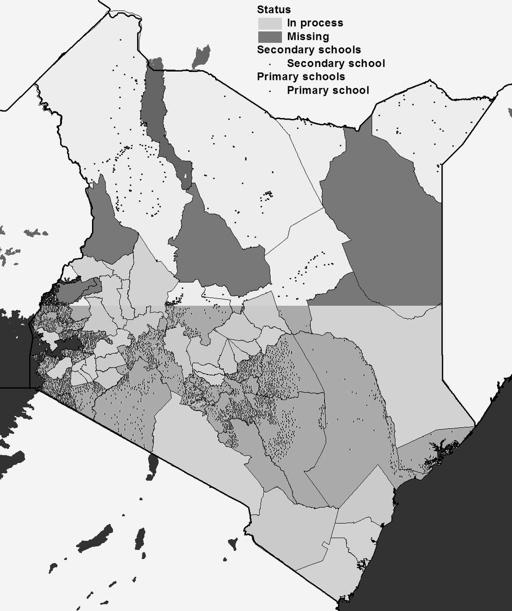
3 What is GIS? Geographic Information System A computer software program that contains geo-referenced data layers Data layers are referenced by points, lines, areas (polygons), or images (satellite info) Information at any scale: facilities to localities to districts to Kenya as a whole Powerful tool to analyze and integrate complex data sets from different sources Integrate spatial aspects of problems into planning and solutions Spatial representation of data is useful in both analysis and dissemination phases Students and Households Schools Infrastructure & Environment Community Census Data School Catchment Area All on a Common Coordinate Basemap

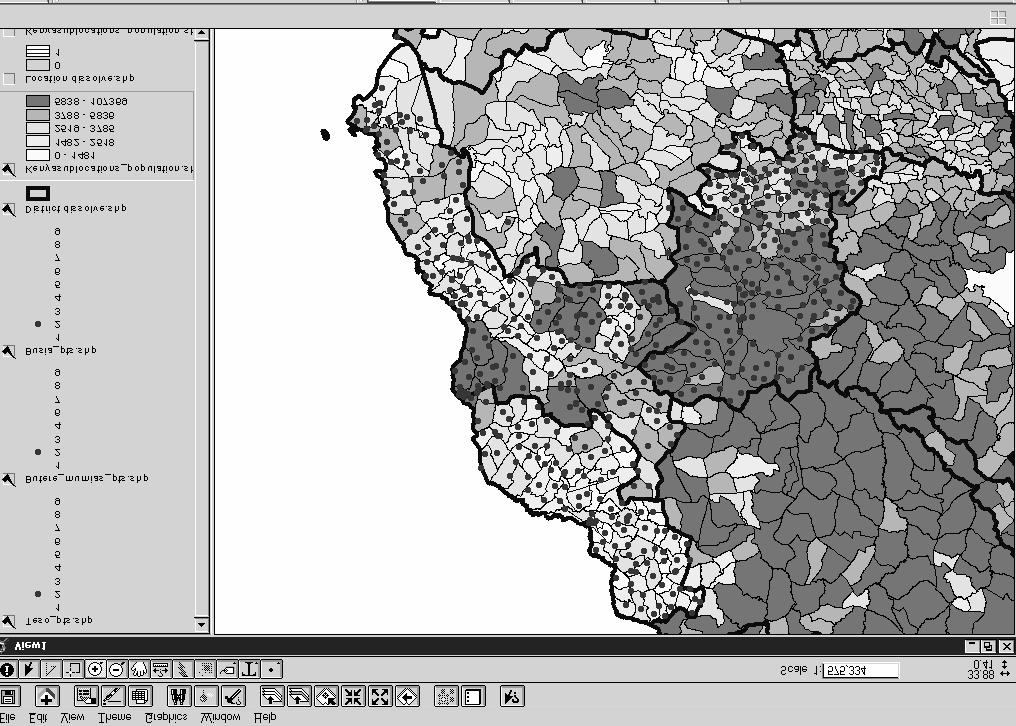
4 Poverty Density Map (1999)
5
6
7
8 Potential uses of Integrated GIS databases Database and tool for: Policy planning and evidence-based targeting of resources Monitoring and Process Evaluation Impact Evaluation Dissemination and communication Towards harmonization among donors, bilaterals, NGOs and other development partners Some resource targeting examples for education Targeting of infrastructure New & upgrading classrooms (quality & crowding issue) New schools (quantity & access issue) Targeting OVC s Targeting of School Bursaries
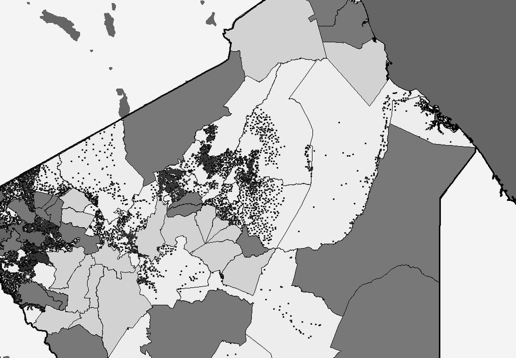
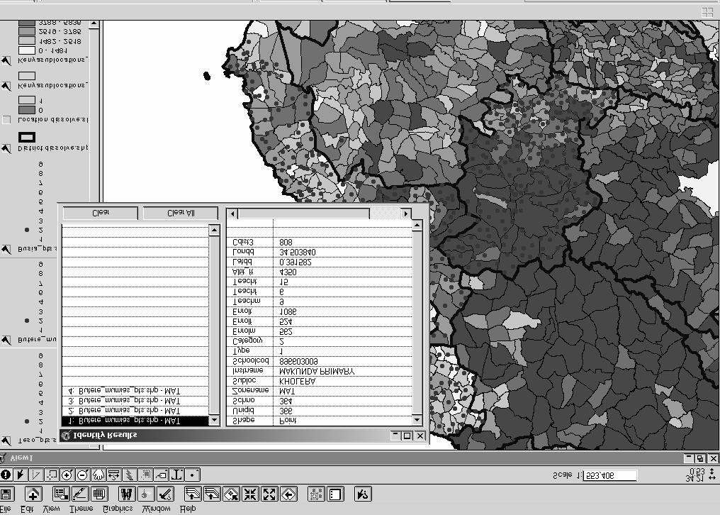
9 Targeting Example: Where to build new classrooms? School census data (2003) integrated with maps: Example for 3 districts Geographic Targeting Rule Based on simple outcome indicator: Ratio of number of enrolled pupils per classroom (quality adjusted) per school Compute geographic averages of the indicator 2 Simulations: Target at District Level Target at Location level
10
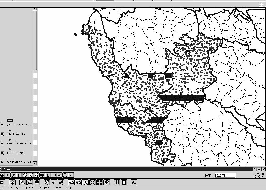
11 Targeting Example: Where to build new classrooms? (cont.) Imagine only funds to target 1 Districts and only 3 Districts in Kenya District-Level Simulation: Butere-Mumias has highest crowding indicator (relative to Busia and Teso) Uniformly allocate funds to all schools in Butere- Mumias Rationale for Targeting at the Location-Level Leakage : not all schools in Butere-Mumias are overcrowded Coverage : some schools in Busia and Teso have over-crowding indicator that are worse than the average school in Butere-Mumias
12 Location-Level Means District-Level Means pcratio_loc pcratio_dis
13
14 Targeting Example: Where to build new classrooms? (cont.) Targeting at finer levels of geographic detail can minimize leakage and maximize coverage Caveats: Targeting at school level Do different but close correlated targeting indicators yield similar results? Sensitivity analysis Are the data precise and accurate? Verification and feedback process coordinated with, for instance, District Education Boards, Inspectors Implementation costs and effectiveness How low can we go? risk and cost-benefit analysis Program design crucial
15 Targeting Example: Where to build new schools? Access issue in which areas are gross enrollment rates low? School catchment area computation School locations known Population numbers and composition known at sub-location, village and EA levels (from population census database) link population census into database Compute school catchment areas: km radius (or time) in walking distance, or if applicable, other transport means Compute covered and non-covered target population (e.g., primary school aged children) Integrate additional information to determine catchment area or explain non-coverage/non-attendance (e.g., road network, cultural issues).
16 Targeting Example: Where to build new schools? (cont.) School catchment area computation Integrate additional information to determine catchment area (e.g., road network) and areas lacking coverage, and explain non-attendance (cultural issues, poverty levels) supply versus demand
17
18
19 Targeting Who and How: Approaches Means & Proxy-Means tests Individuals Community based targeting Groups Demographic targeting Groups Geographic targeting Groups
20 The Big Picture Are Public Expenditures Targeted to the Poor? Size of the budget about $US 2.2bn ( ) Recurrent, Developmental and Core Poverty Expenditures Treasury accounting breaks down the budget: Votes (Ministry), Headings, Sub-Headings (District) and Items. Only 5.5% of the overall Government budget is tracked to the District level in Treasury (Paymaster General) database
21 The Big Picture Are Public Expenditures Targeted to the Poor? Total Expenditures for selected Ministries ( ) 60,000 20% 18% 50,000 16% Ksh (million) 40,000 30,000 20,000 14% 12% 10% 8% 6% % tracked by District 10,000 4% 2% 0 Education [29%] OP [14%] Health [7%] Public Works [6%] Agriculture [4%] 0%
22 The Big Picture Are Public Expenditures Targeted to the Poor? Key Data Sources: Treasury - Paymaster General: printed and actual and detail by sub-heading (Districts) Auditor General: detail on divergence between printed and actual; no sub-heading info Individual ministries need to make an assessment of routinely collected data available Currently no central system in place to track public expenditures by Ministries to Districts!!!
23 Towards Building Integrated GIS Databases Step 1: Building up the Database Geo-reference service delivery locations (point coordinates) and build the base facility-level layer MoEST school mapping project, Health facilities and dispensaries Data verification and validation Collaboration among actors!!!
24 Towards Building Integrated GIS Databases Step 2: Integrate Data Layers - examples School Census Data (2003) At the facility level Link MoEST school code to GIS location Integrate all the info collected from the school census EMIS data can be used for annual updating of database National Exam Registration and Results (annual) At the facility level Link MoEST to KNEC school code KCPE and KCSE data from KNEC MoEST and TSC staffing and expenditure data (annual) At the facility & administrative levels Link MoEST to TSC codes and MoEST budget lines
25 Building an Integrated MoEST GIS Database (cont.) Step 2: Integrate Data Layers (cont.) Population Census Data (1999) Population (by age and sex) per sub-location Orphans (by sex and type) per sub-location Additional population characteristics Update every 10 years and annually with demographic estimates (from CBS MPND) Health facilities and dispensaries Physical Infrastructure and Community Information (various years and sources) Road network Electricity Water Topographic (1:50000) maps
26 Challenges for Completing an Integrated GIS Database Collaboration is critical: fortunately the incentives are present positive network externalities Technical: Verification, cleaning and facility layer compilation Data integration: Coding Correspondence Critical e.g., MoEST, KNEC, TSC e.g., clusters from different surveys GIS Data Management System Sustainability! Investments Needed Physical (computers, software, etc) Human (training, etc)
Poverty Mapping, Policy Making and Operations
 Poverty Mapping, Policy Making and Operations Some Applications from Kenya (DECDG) Using Poverty Maps to Design Better Policies and Interventions Washington DC May 11, 2006 Outline Poverty Mapping process
Presented to Sub-regional workshop on integration of administrative data, big data and geospatial information for the compilation of SDG indicators
 Presented to Sub-regional workshop on integration of administrative data, big data and geospatial information for the compilation of SDG indicators 23-25 April,2018 Addis Ababa, Ethiopia By: Deogratius
Poverty Maps: Uses and Caveats. Tara Vishwanath Lead Economist World Bank
 Poverty Maps: Uses and Caveats Tara Vishwanath Lead Economist World Bank Uses of Poverty Maps A visual illustration of estimated poverty indices at DS division level or below (currently excluding N-E E
RETA 6422: Mainstreaming Environment for Poverty Reduction Category 2 Subproject
 RETA 6422: Mainstreaming Environment for Poverty Reduction Category 2 Subproject A. Basic Data 1. Subproject Title: Poverty-Environment Mapping to Support Decision Making 2. Country Director: Adrian Ruthenberg
Holistic Planning for Urban & Rural Health Care Infrastructure: A Case Study for a District in India
 Holistic Planning for Urban & Rural Health Care Infrastructure: A Case Study for a District in India Sanjay Sinha 1, Priyanka Sharma 2 1 Knowledge Expert (Geo Analytics), Boston Consulting Group 2 Senior
The World Bank Decentralized Community Driven Services Project (P117764)
") Public Disclosure Authorized AFRICA Benin Social Protection Global Practice IBRD/IDA Adaptable Program Loan FY 2012 Seq No: 6 ARCHIVED on 12-Jun-2015 ISR19748 Implementing Agencies: Public Disclosure Authorized
Public Disclosure Authorized AFRICA Benin Social Protection Global Practice IBRD/IDA Adaptable Program Loan FY 2012 Seq No: 6 ARCHIVED on 12-Jun-2015 ISR19748 Implementing Agencies: Public Disclosure Authorized
Status and Challenges on Geo-DRM Information Systems in Tonga
 Name: Mafua- i-vai utukakau Maka Status and Challenges on Geo-DRM Information Systems in Tonga 1 Roles and Relationships Land and Geographic Information Systems (LGIS) Unit: Establish updated high-resolution
Geotargeting. Cost and impact implications
 Geotargeting Cost and impact implications What are poverty maps? Poverty mapping, the spatial representation and analysis of indicators of human wellbeing and poverty within a region What can poverty maps
Implementation Status & Results Congo, Republic of Rep. of Congo - Water, Electricity & Urban Development SIL (LEN) (P106975)
 (P106975)") Public Disclosure Authorized Public Disclosure Authorized The World Bank Implementation Status & Results Congo, Republic of Rep. of Congo - Water, Electricity & Urban Development SIL (LEN) (P106975) Operation
Public Disclosure Authorized Public Disclosure Authorized The World Bank Implementation Status & Results Congo, Republic of Rep. of Congo - Water, Electricity & Urban Development SIL (LEN) (P106975) Operation
The Efforts of Building GIS Infrastructure in a Newly Independent State: The case of Timor Leste *
 UNITED NATIONS E/CONF.100/IP.12 ECONOMIC AND SOCIAL COUNCIL Eighteenth United Nations Regional Cartographic Conference for Asia and the Pacific Bangkok, 26-29 October 2009 Item 7(b) of the provisional
CENSUS MAPPING WITH GIS IN NAMIBIA. BY Mrs. Ottilie Mwazi Central Bureau of Statistics Tel: October 2007
 CENSUS MAPPING WITH GIS IN NAMIBIA BY Mrs. Ottilie Mwazi Central Bureau of Statistics E-mail: omwazi@npc.gov.na Tel: + 264 61 283 4060 October 2007 Content of Presentation HISTORICAL BACKGROUND OF CENSUS
Challenges and Successes in Sharing Geospatial Data in Africa
 Challenges and Successes in Sharing Geospatial Data in Africa 2018 GeoNode Summit Torino, Italy March 26-28, 2018 Bernard Justus Muhwezi Manager, Geo-Information Services Uganda Bureau of Statistics, Kampala,
How GIS can be used for improvement of literacy and CE programmes
 How GIS can be used for improvement of literacy and CE programmes Training Workshop for Myanmar Literacy Resource Center (MLRC) ( Yangon, Myanmar, 11 20 October 2000 ) Presented by U THEIN HTUT GEOCOMP
Methodological issues in the development of accessibility measures to services: challenges and possible solutions in the Canadian context
 Methodological issues in the development of accessibility measures to services: challenges and possible solutions in the Canadian context Alessandro Alasia 1, Frédéric Bédard 2, and Julie Bélanger 1 (1)
Egypt Public DSS. the right of access to information. Mohamed Ramadan, Ph.D. [R&D Advisor to the president of CAPMAS]
![Egypt Public DSS. the right of access to information. Mohamed Ramadan, Ph.D. [R&D Advisor to the president of CAPMAS]](/thumbs/89/98483713.jpg "Egypt Public DSS. the right of access to information. Mohamed Ramadan, Ph.D. [R&D Advisor to the president of CAPMAS]") Egypt Public DSS ì the right of access to information Central Agency for Public Mobilization and Statistics Arab Republic of Egypt Mohamed Ramadan, Ph.D. [R&D Advisor to the president of CAPMAS] Egypt
Egypt Public DSS ì the right of access to information Central Agency for Public Mobilization and Statistics Arab Republic of Egypt Mohamed Ramadan, Ph.D. [R&D Advisor to the president of CAPMAS] Egypt
Opportunities and challenges of HCMC in the process of development
 Opportunities and challenges of HCMC in the process of development Lê Văn Thành HIDS HCMC, Sept. 16-17, 2009 Contents The city starting point Achievement and difficulties Development perspective and goals
Impact Evaluation of Rural Road Projects. Dominique van de Walle World Bank
 Impact Evaluation of Rural Road Projects Dominique van de Walle World Bank Introduction General consensus that roads are good for development & living standards A sizeable share of development aid and
Exploring GIS Potential for Northwestern Ontario Land Information Ontario
 Exploring GIS Potential for Northwestern Ontario Land Information Ontario May 13, 2015 The LIO Vision LIO Vision: That all geographic information about Ontario is fully integrated and accessible LIO Goal:
Indicator: Proportion of the rural population who live within 2 km of an all-season road
 Goal: 9 Build resilient infrastructure, promote inclusive and sustainable industrialization and foster innovation Target: 9.1 Develop quality, reliable, sustainable and resilient infrastructure, including
The efforts building GIS infrastructure in a newly independent state The case of Timor Leste
 The efforts building GIS infrastructure in a newly independent state The case of Timor Leste Paulino da Cruz Ministry of Justice National Directorate of Land and Property and Cadastral Services (DNTPSC)
Council Workshop on Neighbourhoods Thursday, October 4 th, :00 to 4:00 p.m. Burlington Performing Arts Centre
 Council Workshop on Neighbourhoods Thursday, October 4 th, 2012 1:00 to 4:00 p.m. Burlington Performing Arts Centre Agenda Introductions Warm-Up Exercise Presentation Exercise Neighbourhood Planning Break
Implementation Status & Results Benin BN-National Community Driven Development Project (P081484)
") Public Disclosure Authorized Public Disclosure Authorized The World Bank Implementation Status & Results Benin BN-National Community Driven Development Project (P081484) Operation Name: BN-National Community
Public Disclosure Authorized Public Disclosure Authorized The World Bank Implementation Status & Results Benin BN-National Community Driven Development Project (P081484) Operation Name: BN-National Community
LandScan Global Population Database
 LandScan Global Population Database The World s Finest Population Distribution Data Uncommon information. Extraordinary places. LandScan Global Population Database East View Cartographic is now offering
MALDIVES. Regional Expert Workshop On Land Accounting For SDG Monitoring & Reporting (25-27 th Sept 2017) - Fathimath Shanna, Aishath Aniya -
 - Fathimath Shanna, Aishath Aniya -") MALDIVES Regional Expert Workshop On Land Accounting For SDG Monitoring & Reporting (25-27 th Sept 2017) - Fathimath Shanna, Aishath Aniya - ABOUT MALDIVES Approximately 860 km long and 120 km wide Consists
MALDIVES Regional Expert Workshop On Land Accounting For SDG Monitoring & Reporting (25-27 th Sept 2017) - Fathimath Shanna, Aishath Aniya - ABOUT MALDIVES Approximately 860 km long and 120 km wide Consists
Section III: Poverty Mapping Results
 Section III: Poverty Mapping Results Figure 5: Gewog level rural poverty map 58. The most prominent result from the poverty mapping exercise of Bhutan is the production of a disaggregated poverty headcount
Presented at ESRI Education User Conference, July 6-8, 2001, San Diego, CA
 Presented at ESRI Education User Conference, July 6-8, 2001, San Diego, CA Irina V. Sharkova, Ph.D., Research Assistant Professor Richard Lycan, Ph.D., Senior Research Associate Population Research Center
Techniques for Science Teachers: Using GIS in Science Classrooms.
 Techniques for Science Teachers: Using GIS in Science Classrooms. After ESRI, 2008 GIS A Geographic Information System A collection of computer hardware, software, and geographic data used together for
FY SUMMARY BUDGET
 SCHOOL Cole Middle School Budgeted Pupil Count 461.0 BEGINNING FUND BALANCE (Includes ALL Reserves) Object/ Source 736,466.00 736,466.00 REVENUES Local Sources 1000-1999 584,080 584,079.95 Intermediate
Preparing the GEOGRAPHY for the 2011 Population Census of South Africa
 Preparing the GEOGRAPHY for the 2011 Population Census of South Africa Sharthi Laldaparsad Statistics South Africa; E-mail: sharthil@statssa.gov.za Abstract: Statistics South Africa (Stats SA) s Geography
Nordic Council of Ministers Grant Programme for Nordic-Baltic Non-Governmental Organisations (NGO) Cooperation 2019 Estonia.
 Cooperation 2019 Estonia.") Nordic Council of Ministers Grant Programme for Nordic-Baltic Non-Governmental Organisations (NGO) Cooperation 2019 Estonia Automatically saved at 15:54 Basic info Step 1 Project Step 2 Partners Step 3
Nordic Council of Ministers Grant Programme for Nordic-Baltic Non-Governmental Organisations (NGO) Cooperation 2019 Estonia Automatically saved at 15:54 Basic info Step 1 Project Step 2 Partners Step 3
MANAGEMENT OF SPATIAL DATA IN MULTIDISCIPLINARY PROJECTS
 MANAGEMENT OF SPATIAL DATA IN MULTIDISCIPLINARY PROJECTS Ir. B.P.J. van den Bergh Resource Analysis Dr. Ir. A. de Vries IWACO BV Working Group IC-19, TC IV-3, WG IV/6 KEY WORDS: Spatial Data Management,
Brazil Paper for the. Second Preparatory Meeting of the Proposed United Nations Committee of Experts on Global Geographic Information Management
 Brazil Paper for the Second Preparatory Meeting of the Proposed United Nations Committee of Experts on Global Geographic Information Management on Data Integration Introduction The quick development of
Available online at I-SEEC Proceeding - Science and Engineering (2013)
") Available online at www.iseec2012.com I-SEEC 2012 Proceeding - Science and Engineering (2013) 409 415 Proceeding Science and Engineering www.iseec2012.com Science and Engineering Symposium 4 th International
Available online at www.iseec2012.com I-SEEC 2012 Proceeding - Science and Engineering (2013) 409 415 Proceeding Science and Engineering www.iseec2012.com Science and Engineering Symposium 4 th International
GIS Monroe Geographic Information System March 14, 2018
 GIS Monroe Geographic Information System March 14, 2018 Goals Maintain Enterprise/County-wide geo-database Increase spatial accuracy of data Build and acquire more data layers Increase use of GIS; as another
Agenda Item B /20 Strategic Budget Development Phase I Preliminary Recommendations
 Agenda Item B-24 2019/20 Strategic Budget Development Phase I Preliminary Recommendations Board of Education February 13, 2019 2 Outline Preliminary Recommendations and Discussions School Staffing School
Public Disclosure Copy. Implementation Status & Results Report REVITALIZING EDUCATION DEVELOPMENT IN SIERRA LEONE (P133070)
") Public Disclosure Authorized AFRICA Sierra Leone Education Global Practice Recipient Executed Activities Investment Project Financing FY 2015 Seq No: 4 ARCHIVED on 27-Jun-2016 ISR24052 Implementing Agencies:
Public Disclosure Authorized AFRICA Sierra Leone Education Global Practice Recipient Executed Activities Investment Project Financing FY 2015 Seq No: 4 ARCHIVED on 27-Jun-2016 ISR24052 Implementing Agencies:
Oman NSDI Business Values and Future Directions. Hassan Alawi Alghazali Acting Director General National Spatial Data Infrastructure
 Oman NSDI Business Values and Future Directions Hassan Alawi Alghazali Acting Director General National Spatial Data Infrastructure Presentation Outline Geospatial Maturity Current Challenges NCSI s Role
The World Bank Health System Performance Reinforcement Project (P156679)
") Public Disclosure Authorized AFRICA Cameroon Health, Nutrition & Population Global Practice IBRD/IDA Investment Project Financing FY 2016 Seq No: 3 ARCHIVED on 14-Apr-2017 ISR27518 Implementing Agencies:
Public Disclosure Authorized AFRICA Cameroon Health, Nutrition & Population Global Practice IBRD/IDA Investment Project Financing FY 2016 Seq No: 3 ARCHIVED on 14-Apr-2017 ISR27518 Implementing Agencies:
compass.durhamnc.gov Building Community by Illustrating Community Durham s Neighborhood Compass
 Building Community by Illustrating Community Durham s Neighborhood Compass A presentation by John Killeen Rob Cushman Tyler Waring Neighborhood Improvement Services & Technology Solutions City of Durham,
Qatar Statistical Geospatial Integration
 Qatar Statistical Geospatial Integration A Presentation by the Ministry of Development Planning & Statistics (MDPS), State of Qatar http://www.mdps.gov.qa (Fourth UN-GGIM Arab States Committee Meeting,
Regional GIS Presentation for Small and Large Jurisdictions. Michelle E. Fults GIS Manager January 8, 2009
 Regional GIS Presentation for Small and Large Jurisdictions Michelle E. Fults GIS Manager January 8, 2009 Presentation Contributions from Juston Manville Henrico County Kevin Nelson Hanover County Mark
Combining Geospatial and Statistical Data for Analysis & Dissemination
 Combining Geospatial and Statistical Data for Analysis & Dissemination (with Special Reference to Qatar Census 2010) Presentation by Mansoor Al Malki, Director of IT Department Qatar Statistics Authority
GIS FOR MAZOWSZE REGION - GENERAL OUTLINE
 GIS FOR MAZOWSZE REGION - GENERAL OUTLINE S. Bialousz 1), K Mączewski 2), E. Janczar 2), K. Osinska-Skotak 1) 1) Warsaw University of Technology, Warsaw, Poland 2) Office of the Surveyor of the Mazowieckie
The World Bank Community Development Program Support Project-Phase III (P144637)
") Public Disclosure Authorized AFRICA Cameroon Social, Urban, Rural and Resilience Global Practice Global Practice IBRD/IDA Investment Project Financing FY 2016 Seq No: 6 ARCHIVED on 27-Jun-2018 ISR33107
Public Disclosure Authorized AFRICA Cameroon Social, Urban, Rural and Resilience Global Practice Global Practice IBRD/IDA Investment Project Financing FY 2016 Seq No: 6 ARCHIVED on 27-Jun-2018 ISR33107
The World Bank Strengthening Social Safety Net Project (P145699)
") Public Disclosure Authorized Public Disclosure Authorized Public Disclosure Authorized Public Disclosure Authorized MIDDLE EAST AND NORTH AFRICA Egypt, Arab Republic of Social Protection & Labor Global
Public Disclosure Authorized Public Disclosure Authorized Public Disclosure Authorized Public Disclosure Authorized MIDDLE EAST AND NORTH AFRICA Egypt, Arab Republic of Social Protection & Labor Global
Health GIS Tools and Applications Informing Decisions in Yemen
 Health GIS Tools and Applications Informing Decisions in Yemen Prepared by: Carleen Ghio 1, Mark Landry 1, Abdulkadir Nueman 2, and Ahmed Attieg 3 Presented at: Map Middle East Conference April 23-25,
ADDRESSING THE DATA AND INFORMATION NEEDS FOR GOOD GOVERNANCE, SHARING EXPERIENCES FROM COTE D IVOIRE. 20 April 2016 to 22 April 2016 ADDIS ABABA
 20 April 2016 to 22 April 2016 ADDIS ABABA ADDRESSING THE DATA AND INFORMATION NEEDS FOR GOOD GOVERNANCE, SHARING EXPERIENCES FROM COTE D IVOIRE Dr. Edouard FONH-GBEI Director General of CNTIG, General
Urban-Rural Partnerships in Europe
 Disclaimer: The views expressed in this document are those of the author, and do not necessarily reflect the views and policies of the Asian Development Bank (ADB), its Board of Directors, or the governments
SA Geospatial Analysis Platform (GAP) Methodology*, collaborators & data sources
 Methodology*, collaborators & data sources") SA Geospatial Analysis Platform (GAP) Methodology*, collaborators & data sources Mesoframe CSIR, dti, the Presidency & GTZ Demarcation of South Africa into a grid of 50 Km 2 mesozones, nested within important
SA Geospatial Analysis Platform (GAP) Methodology*, collaborators & data sources Mesoframe CSIR, dti, the Presidency & GTZ Demarcation of South Africa into a grid of 50 Km 2 mesozones, nested within important
Economic and Social Council
 United Nations Economic and Social Council Distr.: General 18 July 2016 Original: English Committee of Experts on Global Geospatial Information Management Sixth session New York, 3-5 August 2016 Item 2
Stop TB workshop on grant negotiation and implementation. The workplan and budget: from proposal to implementation. Geneva, December
 Stop TB workshop on grant negotiation and implementation The workplan and budget: from proposal to implementation Geneva, 11-14 December Agenda 3 main topics 1. How do we move from workplans and budgets
Spatial Variation in Local Road Pedestrian and Bicycle Crashes
 2015 Esri International User Conference July 20 24, 2015 San Diego, California Spatial Variation in Local Road Pedestrian and Bicycle Crashes Musinguzi, Abram, Graduate Research Assistant Chimba,Deo, PhD.,
Experience of Mexico in using GIS and spatial
 Experience of Mexico in using GIS and spatial data as a tool for data integration Francisco Javier Jimenez Nava Deputy General Director of Natural Resources and Environment Outline Introduction National
Experiences with the Development and Use of Poverty Maps
 Experiences with the Development and Use of Poverty Maps Case Study Note for MALAWI * 1. Background information on the poverty mapping initiative Recognizing the growing demand for high-resolution poverty
Managing Growth: Integrating Land Use & Transportation Planning
 Managing Growth: Integrating Land Use & Transportation Planning Metro Vancouver Sustainability Community Breakfast Andrew Curran Manager, Strategy June 12, 2013 2 Integrating Land Use & Transportation
GEOGRAPHIC INFORMATION SYSTEMS Session 8
 GEOGRAPHIC INFORMATION SYSTEMS Session 8 Introduction Geography underpins all activities associated with a census Census geography is essential to plan and manage fieldwork as well as to report results
Sidestepping the box: Designing a supplemental poverty indicator for school neighborhoods
 Sidestepping the box: Designing a supplemental poverty indicator for school neighborhoods Doug Geverdt National Center for Education Statistics Laura Nixon U.S. Census Bureau 2018 Annual meeting of the
Integration of Geo spatial and Statistical Information: The Nepelese Experience
 Integration of Geo spatial and Statistical Information: The Nepelese Experience Krishna Raj B.C. Joint Secretary Ministry of Land Reform and Management, Nepal 11 June, 2014 Presentation Outline The Country
GIS = Geographic Information Systems;
 What is GIS GIS = Geographic Information Systems; What Information are we talking about? Information about anything that has a place (e.g. locations of features, address of people) on Earth s surface,
The Church Demographic Specialists
 The Church Demographic Specialists Easy-to-Use Features Map-driven, Web-based Software An Integrated Suite of Information and Query Tools Providing An Insightful Window into the Communities You Serve Key
Economic and Social Council
 United Nations Economic and Social Council Distr.: General 23 May 2012 Original: English E/CONF.101/100 Tenth United Nations Conference on the Standardization of Geographical Names New York, 31 July 9
GDDS2: GIS AND SMALL AREA STATISTICS. Page 1 of 6
 GDDS2: GIS AD SMALL AREA STATISTICS GDDS2: CHECKLIST Ghana GHAA: AEXURE C Background ame of country Ghana Size of population 21m % of population in urban App 60% Size of country (sq km) 238533 sqkm Geographical
The AMGI project: A Brief Overview
 The AMGI project: A Brief Overview World Bank Group (Energy & Extractives Global Practice) GEEDR Francisco Igualada (figualada@worldbank.org) Presented by Ash Johnson, Geosoft Inc. The AMGI Project: Vision
Turkey s National SDI Implementation
 Onur PAŞAOĞULLARI Head of Department Turkey s National SDI Implementation Presentation Plan NSDI Background General Directorate of Geographic Information Systems NSDI Project INSPIRE Directive Urban Information
Secretary for Gender, Child & Community Development
 Ministry of Gender, Child & Community Development Vote Number: 320 Controlling Officer: 1. Overview 1.1 Mission To Promote and protect women and children using community based and welfare approaches 1.2
National Cartographic Center
 National Cartographic Center NCC activities and accomplishments Activities of national organizations, institutions and universities in field of geomatics Large scale maps Medium scale maps Small scale
Finding Poverty in Satellite Images
 Finding Poverty in Satellite Images Neal Jean Stanford University Department of Electrical Engineering nealjean@stanford.edu Rachel Luo Stanford University Department of Electrical Engineering rsluo@stanford.edu
EuroSDR (European Spatial Data Research)
") EuroSDR (European Spatial Data Research) ROLLING RESEARCH PLAN 2015-2018 EuroSDR Secretariat Public Governance Institute KU Leuven Parkstraat 45 bus 3609 3000 Leuven Belgium Tel.: +32 16 32 31 80 Fax:
EuroSDR (European Spatial Data Research) ROLLING RESEARCH PLAN 2015-2018 EuroSDR Secretariat Public Governance Institute KU Leuven Parkstraat 45 bus 3609 3000 Leuven Belgium Tel.: +32 16 32 31 80 Fax:
The World Bank Pakistan: Third Punjab Education Sector Project (P154524)
") Public Disclosure Authorized SOUTH ASIA Pakistan Education Global Practice IBRD/IDA Investment Project Financing FY 2016 Seq No: 2 ARCHIVED on 14-Apr-2017 ISR27416 Implementing Agencies: Public Disclosure
Public Disclosure Authorized SOUTH ASIA Pakistan Education Global Practice IBRD/IDA Investment Project Financing FY 2016 Seq No: 2 ARCHIVED on 14-Apr-2017 ISR27416 Implementing Agencies: Public Disclosure
Policy Paper Alabama Primary Care Service Areas
 Aim and Purpose Policy Paper Alabama Primary Care Service Areas Produced by the Office for Family Health Education & Research, UAB School of Medicine To create primary care rational service areas (PCSA)
System of collecting social statistics
 PHILIPPINES Inception Meeting System of collecting social statistics The Philippines has a decentralized system. It is composed of a policy-making body data producers data users research and training institutions
Implementation Status & Results Indonesia Improving Governance for Sustainable Indigenous Community Livelihoods in Forested Areas (P130632)
") Public Disclosure Authorized Public Disclosure Authorized The World Bank Implementation Status & Results Indonesia Improving Governance for Sustainable Indigenous Community Livelihoods in Forested Areas
Public Disclosure Authorized Public Disclosure Authorized The World Bank Implementation Status & Results Indonesia Improving Governance for Sustainable Indigenous Community Livelihoods in Forested Areas
APPENDIX PHASE 1 GREEN INFRASTRUCTURE FRAMEWORK
 APPENDIX PHASE 1 GREEN INFRASTRUCTURE FRAMEWORK KANSAS MISSOURI CONTENTS A DATA WISHLIST 4 B PRECEDENTS 7 C WORKSHOP MATERIALS 13 D ANALYSIS PROCESS 124 E ATLAS & PLAYBOOK DETAILS 156 F POLICY ANALYSIS
Community Targeting for Poverty Reduction in Burkina Faso
 Community Targeting for Poverty Reduction in Burkina Faso by* David Bigman Stefan Dercon Dominique Guillaume Michel Lambotte Abstract: The paper develops a method for targeting anti-poverty programs and
DEPARTMENT OF GEOLOGY AND MINERAL INDUSTRIES WAYS & MEANS SUBCOMMITTEE ON NATURAL RESOURCES MARCH 2, 2017
 DEPARTMENT OF GEOLOGY AND MINERAL INDUSTRIES WAYS & MEANS SUBCOMMITTEE ON NATURAL RESOURCES MARCH 2, 2017 1 ABOUT DOGAMI AGENCY MISSION, VISION & GOALS 2 Lidar image of a stream network along the Umpqua
GIS Geographical Information Systems. GIS Management
 GIS Geographical Information Systems GIS Management Difficulties on establishing a GIS Funding GIS Determining Project Standards Data Gathering Map Development Recruiting GIS Professionals Educating Staff
PROGRAM EVALUATION REPORT The following information is organized by CACREP-Accredited Program Specialty Areas for
 PROGRAM EVALUATION REPORT 2016-2017 For the 2016-2017 academic year, DePaul Counseling Program faculty conducted a program evaluation by reviewing available data and surveying stakeholders. The following
The World Bank Citizen Voice and Action for Government Accountability (P147834)
") Public Disclosure Authorized EAST ASIA AND PACIFIC Indonesia Health, Nutrition & Population Global Practice Recipient Executed Activities Investment Project Financing FY 2014 Seq No: 3 ARCHIVED on 24-Jan-2017
Public Disclosure Authorized EAST ASIA AND PACIFIC Indonesia Health, Nutrition & Population Global Practice Recipient Executed Activities Investment Project Financing FY 2014 Seq No: 3 ARCHIVED on 24-Jan-2017
OC Enterprise GIS. Kevin Hills, PLS Cameron Smith, GISP. OC Survey
 OC Enterprise GIS Kevin Hills, PLS Cameron Smith, GISP OC Survey Discussion Points Background & Organizational Structure of OCPW Past practices prior to Enterprise Wide GIS License (ELA) Participating
Experiences with the Development and Use of Poverty Maps
 Experiences with the Development and Use of Poverty Maps Case Study Note for VIETNAM * 1. Background information on the poverty mapping initiative The development of the first poverty map in Vietnam was
Preparation of Database for Urban Development
 Preparation of Database for Urban Development By PunyaP OLI, 1. Chairman, ERMC (P) Ltd., Kathmandu, Nepal. Email: punyaoli@ermcnepal.com 2. Coordinator, Himalayan College of Geomatic Engineering and Land
Towards Reliable Spatial Database of Informal Areas in Greater Cairo Region
 KEYWORDS informal areas, unreliable spatial data, spatial data collecting, capacity building SUMMARY The uncontrolled and rapid increase of Egypt s cities is a major problem of the country. More than the
SUPPORTS SUSTAINABLE GROWTH
 DDSS BBUUN NDDLLEE G E O S P AT I A L G O V E R N A N C E P A C K A G E SUPPORTS SUSTAINABLE GROWTH www.digitalglobe.com BRISBANE, AUSTRALIA WORLDVIEW-3 30 CM International Civil Government Programs US
Sindh Enhancing Response to Reduce Stunting (P161624)
") Public Disclosure Authorized SOUTH ASIA Pakistan Health, Nutrition & Population Global Practice IBRD/IDA Investment Project Financing FY 2017 Seq No: 3 ARCHIVED on 01-Oct-2018 ISR33776 Implementing Agencies:
Public Disclosure Authorized SOUTH ASIA Pakistan Health, Nutrition & Population Global Practice IBRD/IDA Investment Project Financing FY 2017 Seq No: 3 ARCHIVED on 01-Oct-2018 ISR33776 Implementing Agencies:
The World Bank GUINEA - Pooled-Fund for Basic Education (P148127)
") Public Disclosure Authorized AFRICA Guinea Education Global Practice Recipient Executed Activities Investment Project Financing FY 2016 Seq No: 5 ARCHIVED on 21-Dec-2017 ISR29797 Implementing Agencies:
Public Disclosure Authorized AFRICA Guinea Education Global Practice Recipient Executed Activities Investment Project Financing FY 2016 Seq No: 5 ARCHIVED on 21-Dec-2017 ISR29797 Implementing Agencies:
Regional EGM on Community of Practice of Georeferenced Information System. for Disaster Risk Management (Geo-DRM) April 2014, Bangkok, Thailand
 April 2014, Bangkok, Thailand") Regional EGM on Community of Practice of Georeferenced Information System for Disaster Risk Management (Geo-DRM) 23-25 April 2014, Bangkok, Thailand Presented By Mukesh Kumar Keshari Ministry of Home Affairs
Regional EGM on Community of Practice of Georeferenced Information System for Disaster Risk Management (Geo-DRM) 23-25 April 2014, Bangkok, Thailand Presented By Mukesh Kumar Keshari Ministry of Home Affairs
Accessibility as an Instrument in Planning Practice. Derek Halden DHC 2 Dean Path, Edinburgh EH4 3BA
 Accessibility as an Instrument in Planning Practice Derek Halden DHC 2 Dean Path, Edinburgh EH4 3BA derek.halden@dhc1.co.uk www.dhc1.co.uk Theory to practice a starting point Shared goals for access to
SOCIO-DEMOGRAPHIC INDICATORS FOR REGIONAL POPULATION POLICIES
 SOCIO-DEMOGRAPHIC INDICATORS FOR REGIONAL POPULATION POLICIES A CANADIAN PERSPECTIVE Marc Termote Université de Montréal Potsdam, DART Conference, September 3, 2012 3 STEPS 1. Defining the problem 2. Identifying
About the Author: UID data in SPRS profiler. Representation code. Character. STATE OF INDIA Census code of UID-1
 Formulation of Policy & strategies for slum development through Slum Permanent Record System with GIS as E-TOOL Hema Dudhwala Founder and Principal of SPRS Research foundation Director& Proprietor of AAPIL
Use of GIS in road sector analysis
 Use of GIS in road sector analysis Uwe Deichmann, DECRG March 30, 2007 Transport Forum and Learning Week 2007 Transport Measurement Matters Indicators of Performance and Impact Geographic information Using
KENYA NATIONAL BUREAU OF STATISTICS Workshop on
 KENYA NATIONAL BUREAU OF STATISTICS Workshop on Capacity Building in Environment Statistics: the Framework for the Development of Environment Statistics (FDES 2013) Coordination with Sector Ministries
EUROPEAN INVESTMENT BANK
 EUROPEAN INVESTMENT BANK RISC Consortium and the UNU-CRIS Summer School/ Students Research Symposium, 3 rd July 2012, Luxembourg Regional Projects good practice? Kamil Dörfler 1 Outline General background
Purpose Study conducted to determine the needs of the health care workforce related to GIS use, incorporation and training.
 GIS and Health Care: Educational Needs Assessment Cindy Gotz, MPH, CHES Janice Frates, Ph.D. Suzanne Wechsler, Ph.D. Departments of Health Care Administration & Geography California State University Long
Oakland County Parks and Recreation GIS Implementation Plan
 Oakland County Parks and Recreation GIS Implementation Plan TABLE OF CONTENTS 1.0 Introduction... 3 1.1 What is GIS? 1.2 Purpose 1.3 Background 2.0 Software... 4 2.1 ArcGIS Desktop 2.2 ArcGIS Explorer
SECTION DESCRIPTION PAGE I. BUDGET INTRODUCTION... 1 II. FISCAL YEAR 2017 BUDGET ANALYSIS... 2 III. PROPOSED OPERATING BUDGET... 3
 2018 SECTION DESCRIPTION PAGE I. BUDGET INTRODUCTION... 1 II. FISCAL YEAR 2017 BUDGET ANALYSIS... 2 III. PROPOSED OPERATING BUDGET... 3 IV. GENERAL FUND 001 DESCRIPTIONS... 4 V. DEBT SERVICE FUNDS... 6
Martin MENSA, Eli SABLAH, Emmanuel AMAMOO-OTCHERE and Foster MENSAH, Ghana. Key words: Feeder Roads Condition Survey, Database Development
 Digital Mapping and GIS-Driven Feeder Road Network Database Management System for Road Project Planning and Implementation Monitoring in the Feeder Road Sector Martin MENSA, Eli SABLAH, Emmanuel AMAMOO-OTCHERE
Historical background
 Space Technology for Disaster Management in Sri Lanka: Country profile, national perspectives & vision. Professor Ranjith Premalal De Silva Vice Chancellor Uva Wellassa University of Sri Lanka October
INSPIRE in Sweden.
 INSPIRE in Sweden Swedish National Data Service Established 2008. SND is a service organisation for Swedish research within the Humanities, Social Sciences and Medicine. SND is the Swedish node in an international
Ministry of Health and Long-Term Care Geographic Information System (GIS) Strategy An Overview of the Strategy Implementation Plan November 2009
 Strategy An Overview of the Strategy Implementation Plan November 2009") Ministry of Health and Long-Term Care Geographic Information System (GIS) Strategy An Overview of the Strategy Implementation Plan November 2009 John Hill, Health Analytics Branch Health System Information
Ministry of Health and Long-Term Care Geographic Information System (GIS) Strategy An Overview of the Strategy Implementation Plan November 2009 John Hill, Health Analytics Branch Health System Information
Creating a Staff Development Plan with Esri
 Creating a Staff Development Plan with Esri Michael Green David Schneider Guest Presenter: Shane Feirer, University of California Esri UC 2014 Technical Workshop Agenda What is a Staff Development Plan?