INTERNATIONAL COURT OF JUSTICE CASE CONCERNING MARITIME DELIMITATION IN THE BLACK SEA RE JOINDER SUBMITTED BY UKRAINE
|
|
|
- Hester Terry
- 6 years ago
- Views:
Transcription
1 INTERNATIONAL COURT OF JUSTICE CASE CONCERNING MARITIME DELIMITATION IN THE BLACK SEA (ROMANIA v. UKRAINE) RE JOINDER SUBMITTED BY UKRAINE VOLUME 1 6 JULY 2007
2 i TABLE OF CONTENTS CHAPTER 1. INTRODUCTION CHAPTER 2. JURlSDICTION AND APPLICABLE LAW Section 1. Junsd~ction... 5 Section 2. Applicable Law A. B. The Agreements and the 1997 Exchange of Letters Are Not Agreements of the Kind Referred to in Articles 7414) and 83(4) of UNCLOS The Principles Set Out in the 1997 Exchange of Letters Are Not. As There Set Out. Rules to be Applied by the Court CHAPTER 3. THE STARTING POINT FOR THE DELIMITATION. AND THE ABSENCE OF ANY AGREED PARTIAL DELIMITATION Section 1. The Extent of the Agreed Maritime Boundary Line Along the 12 n.m. Arc Around Serpents' Island A. Introduction I... B. The Proces Verbaux of and C. Maps and Sketches Contemporaneous with the 1949 Prods Verbal D. The Contemporary (1949) Record ~ E. Non-Contemporaneous Maps Section 2. The Status of the Waters on Each Side of the Agreed Line A. Introduction 4 8 B. Status of the Waters Under the 1949 Proces Verbal or Other Agreed Texts C. Status of the Waters Under the International Law of the Sea... 50
3 D. The Alleged "All-Purpose" Maritime Boundary Section 3. Conclusion CHAPTER 4. THE COASTAL GEOGRAPHY Section 1. Introduction Section 2. The Relevant Coasts of Ukraine A. Romania's Attempt to Suppress Half of Ukraine's Coast B. The Court's Jurisprudence Supports Ukraine's Position on the Identification of the Relevant Coasts (i) The Tunisia-Libya Case (ii) TheGuIfofMaineCase (iii) The Denmark-Norway (Jun Mayen) Case (iv) The Cameroon-Nigeria Case......S. 74 C. Serpents' Island as Part of the Relevant Coastal Geography Section 3. Romania's Coast A. B. C. Applying Romania's Projection of Coastal Segments Theory to Its Own Coast Romania's Artificial Distinction between "Opposite Coasts" and "Adjacent Coasts" Romania's Use of Sulina Dyke and the Sacalin Peninsula as Basepoints In Contrast to Its Disregard of Serpents' Island Section 4.. The Relevant Area A. The Northern Area Lying off Ukraine's South-Facing Coast The Eastern Triangle Which Concerns a Third State... (Turkey) 86 C. The Small Sliver of Area in the South... 87
4 CHAPTER 5. THE APPLICATION OF THE GEOGRAPHICAL FACTORS IN THE CONSTRUCTION OF THE PROVISIONAL EQUIDISTANCE LINE Section 1. Introduction Section 2. Selecting the Basepoints for Constructing the Provisional Equidistance Line A. The Relevant Basepoints on Ukraine's Coast B. The Relevant Basepoints on Romania's Coast Section 3. Romania's Biased Approach to Selecting the Relevant Basepoints A. Romania's Inappropriate Disregard of Serpents' Island B. Romania's Flawed Contention that Serpents' Island Is a Relevant Circumstance Section 4. Conclusion 9 6 CHAPTER 6. THE IDENTIFICATION OF THE RELEVANT CIRCUMSTANCES Section 1. Introduction Section 2. The Enclosed Nature of the Black Sea and Third State Delimitations Are Not Relevant Circumstances...: Section 3. The Coastal Geography as a Relevant Circumstance A. Applicable Legal Principles. 107 B. The Geographical Predominance of Ukraine in the Relevant Area C. The Relevance of Serpents' Island for the Delimitation A. General Considerations 120 B. Licences Granted for the Exploration of Oil and Gas C. Surveillance of Illegal Fishing 127
5 CHAPTER 7. THE PARTIES' DELIMITATION LINES Section 1. Introduction Section 2. The Flawed Nature of Romania's Claim Section 3. Ukraine's Delimitation Line CHAPTER 8. TESTING THE EQUITABLE CHARACTER OF THE DELIMITATION Section 1. Application of the Proportionality Test 141 Section 2. he Principle of Non-Encroachment and So-Called "Security" Interests CHAPTER 9. SUMMARY OF UKRAINE'S REASONING 149 SUBMISSIONS LIST OF ANNEXES
6 LIST OF FIGURES Figure 3-1 The Agreed Boundary Line around Serpents' Island A. ExtractofMap134 B. Extract of the Chart Submitted to the UN by Romania in 1997 C Treaty on the State Border Figure 4-1 Ukraine's Relevant Coast Figure 4-2 I1 lustration of the Ukrainian Coast Eliminated by Romania Figure 4-3 Illustration of the Area Excluded by Ukraine's Coastal Projections According to Romania (based on Romania's Figure RR5) Figure 4-4 Projection of Ukraine's Coastal Fronts (drawn as 200 n.m. arcs) Figure 4-5 Illustration of the Relevant and Inelevant Coasts in the Tunisia - Libya Case Figure 4-6 IIEustration of the Relevant Coasts in the Gulfof Maine Case Figure 4-7 Illustration of the Relevant Coasts in the Denmark - Noway (Jan Mayen) Case Figure 4-8 Topographical Map of Serpentst Island Figure 4-9 Romania's Coastal Projections Figure The Relevant Coasts of the Parties and the Relevant Area Figure The Differences between the Parties regarding the Relevant Area
7 Figure 5-1 The Provisional Equidistance Line Figure 5-2 Ukraine's Straight Baselines notified to the United Nations in 1992 Figure 6-1 Location of Interceptions of Turkish and Bulgarian Fishing Vessels by the Ukrainian Coast Guard Figure 6-2 The Parties' Oil and Gas and Fisheries Surveillance Activities Figure 7-1 The Effect of Romania's Selective Use of Basepoints on the Provisional Equidistance Line Figure 7-2 Extract from Romania's Figure RR29 Figure 7-3 Ukraine's Delimitation Line Figure 8- l The Proportionality Test Applied to Ukraine's Delimitation Line Figure 8-2 The Proportionality Test, Taking into Account Romania's Treatment of Ukraine's Coast Figure 8-3 The Proportionality Test, Taking into Account the Combined Relevant Areas Proposed by the Parties
8 vii LIST OF PHOTOGRAPHS Photograph A Photograph B Aerial View of Serpents' Island from the Northeast Aerial View of Serpents' Island from the West
9 -1- CHAPTER 1 INTRODUCTION 1.1. This Rejoinder is filed by Ukraine in accordance with the Order of the Court dated 8 June 2007, fixing 6 July 2007 as the time-limit for the submission of Ukraine's Rejoinder The initial statement of Ukraine's case was made in Ukraine's Counter-Memorial filed on E9 May 2006, in which Ukraine responded to the case presented by Romania in its Memo~al of 19 August Romania filed a Reply on 22 December 2006, and this Rejoinder responds to Romania's Reply. 1.3 In presenting this Reply Ukraine has taken full account the terms of Article 49, paragraph 3, of the Rules of Court which reads: "The Reply and Rejoinder, whenever authorized by the Court, shall not merely repeat the parties' contentions, but shall be directed to bringing out the issues that still divide them. " 1.4. In this Rejoinder Ukraine will accordingly concentrate on those issues that still divide the Parties in the light of the Reply submitted by Romania. In focussing in this way on certain issues only, and in therefore not repeating everything already said in Ukraine's Counter- Memorial, Ukraine is not to be taken as in any way resiling from the positions which it there adopted, For the avoidance of doubt, Ukraine hereby confirms its previous exposition of its position, except to the extent, if any, that it may be expanded or modified by the terms of this Rejoinder In short, Ukraine has found nothing in Romania's Reply which calls for Ukraine to withdraw or modify any of the positions which it adopted in its Counter-Memorial. Accordingly, this Rejoinder will concentrate on demonstrating further the erroneousness of Romania's position as developed in its Reply either cafe reovo or by way of elaboration of matters already set out in its Memorial. Ukraine will not respond to the Appendix to
10 Romania's Repf y where Romania addresses what it terms the "Diplomatic History Relative to the Dispute". The historical matters raised therein are not relevant ta this case and are not accepted by Ukraine, which has already commented on these matters as necessary in Chapter 5, Section 2, of its Counter-Memorial, l.6. Ukraine's Rejoinder comprises 9 Chapters, including this introductory Chapter Chapter 2 discusses the extent of the Court's jurisdiction in this case, emphasising that the texts which determine the jurisdiction of the Court limit its jurisdiction to determining the continental shelf and EEZ boundaries of the two States, and do not include the determination of any maritime boundaries involving the territorial sea. Chapter 2 also addresses the law to be applied by the Court in deciding upon the continental shelf and EEZ boundary between Ukraine and Romania in the Black Sea, demonstrating that, contrary to Romania's position, the applicable law is the law to be applied in accordance with Article 38 of the Statute of the Court and not, as Romania contends, various principles expressly aped by the Parties only for the purpose of their (ultimately unsuccessful) negotiations Chapter 3 considers the starting point for the Court's delimitation task, which the Parties agree lies at the point at which the outer limits of Ukraine's and Romania's territorial seas intersect, as agreed in the 2003 Treaty between Ukraine and Romania on the Regime of the Ukrainian-Romania State Border, Collaboration and Mutual Assistance in Border Matters ("the 2003 Ukraine-Romania Treaty" or "the 2003 Treaty").' Chapter 3 shows that, contrary to Romania's position, there is no agreed maritime boundary running further east than that agreed point, and thus that there is no agreed partial delimitation of the Parties' continental shelf and EEZ boundary beyond that agreed point. The Chapter goes on to consider the status of the relevant waters, and shows that up to the agreed point the waters are territorial sea on either side of the agreed line, and that beyond the agreed point and outside the limits of the Parties' territorial seas they are high seas or open sea, The Chapter further demonstrates that Romania's thesis that some kind of "all-purpose" maritime boundary already exists beyond that agreed starting point is untenable. 1 Ukraine's Counter-Memorial ("UCM"), Vol. 2, Annex 3.
11 1.9. Chapter 4 examines the coastal geography relevant to the delimitation, and responds to Romania's highly selective treatment of the coasts of the Parties which abut the relevant area, in particular Romania" attempt to leave out of account half of Ukraine's coast and Romania's disregard of Serpents' Island. The Chapter shows that Ukraine's position regarding the identification of the relevant coasts is fully consistent with the Court's jurisprudence, and that Romania's treatment of its own coasts is inconsistent with its treatment of Ukraine's coasts. Finally, the Chapter shows that Ukraine's identification of the relevant area is appropriate Chapter 5 follows that examination by considering how the geographical factors are to be applied in the construction of the provisional equidistance line, and deals in particular with the identification and use of the appropriate basepoints on both Ukraine's and Romania's coasts, and with Romania's biased approach to the selection of relevant basepoints including its disregard and misuse of Serpents' Island Chapter 6 identifies the relevant circumstances which are required to be taken into account for the adjustment of the provisional equidistance line in the interests of arriving at a line which represents an equitable result, including consideration of the geography of the area and the Parties' oil and gas activities, and their coastguard activities. The Chapter also shows that, contrary to Romania's contentions, the enclosed nature of the Black Sea and third State delimitations in the Black Sea are not relevant circumstances. 1.l 2. Chapter 7 sets out Ukraine's delimitation line and responds to the erroneous nature of Romania's claim line which fails to reflect a properly constructed provisional equidistance line and the relevant circumstances characterizing the area. Chapter 8 then shows that the equitableness of Ukraine" line is borne out by considerations of proportionali ty Chapter 9 concludes the presentation of Ukraine's case by briefly summarising Ukraine's case, pursuant to the Court's Practice Direction No. 11. Ukraine's Submissions then follow.
12 1.14. This Rejoinder is accompanied by one volume of documentary annexes which is annexed hereto as Volume 2.
13 CHAPTER 2 JURISDICTION AND APPLICABLE LAW Section 1. Jurisdiction 2.1. The Parties disagree about the scope of the Court's jurisdiction in this case. The disagreement is the direct result of (i) Romania's adherence to its unjustified claim that there already exists an agreed all-purpose maritime boundary extending around the south of Serpents' Island to a point approximately due east of that Island, and (ii) Romania's refusal to have regard to the actual terms in which the Parties agreed that their dispute should be referred to the Court Ukraine has shown, and will again show in Chapter 3, that there is no all-purpose maritime boundary around Serpents' Island: the suggestion that such a boundary exists is not substantiated by any legal instruments and is simply wrong. This argument of Romania is further undermined by the fact that the 2003 Treaty established the starting point of the delimitation between the Parties' respective continental shelves and Exclusive Economic Zones. In this first part of this Chapter, however, Ukraine will deal only with the question of jurisdiction. It is Ukraine's view that the Court only has jurisdiction on the basis of what was agreed in the 1997 Ukraine-Romania Treaty and in paragraph 4(h) of the 1997 Exchange of Letters.' Those two texts are clear on the question of jurisdiction. They show that the Court's jurisdiction is limited to determining the continental shelf and EEZ boundaries of Ukraine and Romania. Article 2, paragraph 2, of the 1997 Ukraine-Romania Treaty refers to the "problem of the delimitation of their continental shelf and of exclusive economic zones in the Black Sea"; and paragraph 4(h) of the 1997 Exchange of Letters provides for recourse to the Court in respect of the "delimitation of continental shelf and exclusive economic zones". No mention is made of boundaries involving the territorial sea of either State, and such boundaries are therefore excluded from the Court's jurisdiction. I The Exchange of Letters dated 2 June 1997 is at UCM, Annex 1, Vol. 2. The 1997 Treaty between Ukraine and Romania on the Relations of Good Neighbourliness and Cooperation is at UCM, Annex 2, Vol. 2.
14 2.3. It is Romania's thesis that Ukraine's maritime boundary for all purposes has already been agreed and follows the territorial sea boundary to the south of Serpents' Island as far as a point approximately due east of Serpents' Island (which Romania refers to as Point X), and that to the south of that allegedly agreed line the waters and their seabed and subsoil form part of Romania's continental shelf and EEZ. On this (Romanian) view it follows that the maritime boundary comprises three sectors: (i) the boundary between the 12 nrn territorial seas of the two States as far as the point at which the outer limits of their territorial seas intersect (which is the point specified in Article 1 of the Treaty of 17 June 2003 on the Regime of the Ukrainian-Romanian State Border, Co-operation and Mutual Assistance in Border ~atters)? (ii) the boundary between Romania's continental shelf and EEZ on the one hand and Ukraine's territorial sea around Serpents' Island as far as Romania's Point X, and (iii) the boundary between Romania's and Ukraine's continental shelves and EEZs beyond Point X Moreover, Romania accepts (as does 'Ukraine) that the issue of the boundary line dividing the Parties' respective territorial seas up to the point (which Romania refers to as Point F) where their outer limits intersect as agreed in the 2003 Treaty has not been referred to the court; and that the Court's task in this case begins with the boundary starting at that point of inter~ection.~ It follows that in Romania's view the Court's task is to determine the maritime boundary in sectors (ii) and (iii) identified above. Sector (ii), however, is (on Romania's view) a boundary between the continental shelf and EEZ of one State (Romania) and the territorial sea of the other (Ukraine): it is not a boundary between the two States' UCM, Annex 3, Vol. 2. Romania's Reply ("RR"), para Romania's Memorial ("RM"), paras. 7.19, 9.3; and see RR, para. 8.40, where Romania's proposed delimitation line begins at Point F.
15 continental shelves and EEZs. Even on Romania's own view of the maritime situation it is, therefore, not part of the dispute which the Parties have agreed to refer to the Court Romania, in the treatment of the jurisdictional issue in its ~ e ~ l does ~, not ' address the consequences which have to flow from the actual language agreed by the Parties in expressing their consent to refer their dispute to the Court: Romania simply ignores the agreed language. Instead, Romania develops a completely misconceived argument designed to show that "international courts do not consider themselves inhibited from establishing maritime boundaries separating, on the one hand, the continental shelf (or the exclusive economic zone) of one party and, on the other hand, other maritime areas (including the tenitorial sea) of the other party" This, however, misses the crucial point. The question for consideration is not the Court's general competence to establish maritime boundaries between different categories of waters, but rather the scope of what the Parties expressly consented to submit to the Court's jurisdiction in the present case. That consent is fundamental to the exercise by the Court of jurisdiction in any given case. It is a consent which is to be strictly construed In the Counter-Memorial Ukraine showed7 that its position was comparable to that adopted by the 1977 Anglo-French Court of ~rbitration.~ As Ukraine noted, in that case the Court held that it did not have the power under the terms of the Arbitration Agreement to draw a line between the Channel Islands archipelago and the French coasts of Normandy and Brittany because the line in that area would have been a continental shelf boundary for one party and a territorial sea boundary for the other. Romania argues that Ukraine misinterprets the Court of Arbitration's deci~ion,~ but in doing so Romania itself misunderstands the relevance of that decision for the present case. The Court of Arbitration referred to the task entrusted to it by Article 2(1) of the Arbitration Agreement, which was to decide "what is the course of the boundary (or boundaries) between the portions of the continental shelf 5 At RR, paras Ibid., para UCM, para Case concerning the Delimifafion of the Confinenfal Shelf between the United Kingdom of Great Britain and Northern Ireland, and the French Republic, Decision of 30 June 1977, U.N.R.I.A.A., Vol. XVIII. 9 RR, paras
16 l appertaining to the United Kingdom and the Channel Islands and to the French Republic" - a task whose limitation to the continental shelf boundary was reflected also in the As the Court then said, "It is, therefore, clear that the competence conferred on the Court by Article 2(1) of the Agreement relates specifically to the delimitation in the arbitration area of the boundary of the continental shelf'." The Court then noted the narrow and rock-strewn character of the sea passages between the Channel Islands and the French coasts of Normandy and Brittany, and concluded that: "the 'continental shelf boundary'which the Parties invite the Court to delimit in the areas between the Channel Islands and the coasts of Normandy and Brittany must traverse over almost its whole length waters either claimed by France as part of its territorial sea or by the United Kingdom as part of its actual or potential territorial sea and of its existing fishery one."'^ The Court noted that this meant that: "in order to delimit any form of seabed and subsoil boundary between the Channel Islands archipelago and the coasts of Normandy and Brittany, the Court would have to decide a number of questions in dispute between the Parties regarding the delimitation of the territorial sea of one or other country."13 I I The Court accordingly asked the parties what they considered to be the Court's functions and powers: "with respect to the delimitation of the boundary in areas of seabed and subsoil which certainly form part of the territorial sea of one or other Party or in regard to which there is a difference between the Parties regarding their status as territorial sea or continental she~f."'~ i In the light of the parties' responses the Court, after noting that its competence derived from the consent of both parties, observed that: "it does not suffice to establish the Court's competence that one Party may consider an area to be continental shelf when the other may not unreasonably maintain that any i I 10 At para. 13 of the Decision. I I Ibid. 12 Ibid., para Ibid., para Ibid.
17 delimitation of a boundary in that area will inevitably involve a delimitation of its territorial sea. "I5 The Court went on to find that: "In these circumstances, the Court does not find itself empowered under the terms of Article 2(1) of the Arbitration Agreement to delimit the seabed and subsoil bounda between the Channel Islands archipelago and the coasts of Normandy and ~rittan~."' Y and that: "In the light of the foregoing, and having regard to the geographical circumstances, the precise formulation of its competence in Article 21 1) of the Arbitration Agreement and the repties of the Parties to the Cdust's questions regarding the problem of its competence in the Channel lslands region, the Court considers that it is without competence to delimit any seabed and subsoil boundary in the narrow waters situated between the Channel Islands and coasts of Normandy and Brittany. In the Channel Islands region, therefore, the Court's decision must be confined to deciding the course of the boundary of the continental shelf in the areas to the north and the west of the Channel Islands in so far as this does not involve the delimitation of the territorial sea of either art^."'^ 2.8. In thus holding that it lacked the competence to delimit continental shelf areas in locations where to do so would involve it in delimiting territorial sea areas not unreasonably claimed by either party the Court was clearly concerned not only (as Romania incorrectly suggests1') with a boundary between areas both of which were the territorial sea of the parties, but also with a boundary between areas consisting of the continental shelf of one party and the territorial sea of the other.., 2.9. The Angio-French Arbitration thus demonstrates that the Court of Arbitration, faced with a cornpromis expressly limited to a continental shelf delimitation, held itself to have no competence to delimit a maritime boundary involving either partfs territorial sea. The Court IS Ibid., para. 19, 16 Ibid., para. 20. l7 Ibid., para RR, para It is, for example, apparent from the quotation from the Court's Decision given in para. 1.8 of Romania's Reply that the Court had in mind the consequence that "the 'continental sher bounday which the Parties invite the Court to delimit in the weas between the Channel Islands and the coasts of Normandy and Brittany must traverse over almost its whole length waters either claimed by France as part of its territorial sea, or by rhe Uniled Kingdom as part of its actual or potential ierrilorial sea and of its existing fishery zone" (Decision, para. 14: emphasis added). I.e., the Court was clearly referring to a boundary between waters which in my given location were claimed as territorial sea by either France or the United Kingdom, but not necessarily by both.
18 simply applied, to the letter, the terms of the agreed comprumis: it would apparentiy have been willing to go further if the two parties had consented, but they did not consent and therefore the terms of the cornpromis had to be applied as they stood. That is precisely the position in the present case. Consent is limited to the delimitation of the Parties' continental shelves and EEZs, with nothing said about boundaries which involve their territorial seas. l9 Their consent to the Court's jurisdiction therefore excludes the determination of a maritime boundary in the sector (ii) identified in paragraph 2.3 above That conclusion does not, however, mean that the Court's jurisdiction to determine the Parties' continental, shelf and EEZ boundaries begins at the point where Romania's sector (ii) ends, namely Romania's Point X approximately due east of Serpents' Island, The Parties agree2' that the Court's task is to determine those boundaries from the starting point of the agreed point of intersection of the outer limits of their respective territorial sea - i.e., the point agreed in the 2003 Treaty. From that agreed point onwards the Court has jurisdiction, under the express terms of the 1997 Treaty and the 1997 Exchange of Letters, to delimit the PaPlfies' continental shelves and EEZs: i.e., the boundary must be such that on each side of the boundary line there needs to be a continental shelf and an EEZ over which Ukraine, on its side of the boundary, and Romania, on its side of the boundary, has its own sovereign rights: the boundary to be delimited by the Court is thus, by virtue of the treaty language in which their consent to the Court's jurisdiction is expressed, a boundary running between the Parties' respective continental shelves and EEZs Romania's thesis that the territorial sea limit around the south of Serpents' Island has already been agreed to be the maritime boundary not only has Eundamental substantive errors which will be explained in the next Chapter, but is also inconsistent with the terms of the Parties' agreement to refer their dispute to the Court: the Romanian thesis results in a boundary running between, on the one hand, Romania's continental shelf and EEZ and, on the other hand, Ukraine's territorial sea, and not, as required by the Parties' agreement to the Court's jurisdiction, between two sets of continental shelves and EEZs. Nor can Romania argue that since (in Romania's view) the 12 mile limit around the south of Serpents' Island is an "all-purpose" maritime boundary it delimits not only the Island's territorial sea but also its 19 2Q See para. 2.2 above, See para, 2.4 above.
19 EEZ and its continental shelf such an argument would be inconsistent with Articles 55 and 76 of UNCLOS, both of which define those maritime zones as being zones "beyond" the territorial sea - in legal terms a continental shelf is a zone lying to the seaward.of the outer limit of the territorial sea, and the shelf S outer boundary cannot therefore follow the same line as the boundary of the territorial sea Ukraine will show in Chapter 3 that Romania's underlying thesis that there is already an agreed maritime boundary extending as far east as Romania's Point X approximately due east of Serpents' Island, and that that boundary is throughout its length an all-purpose maritime boundary, cannot be substantiated." For the moment it is sufficient to note that it will there be shown that the correct position is that the maritime boundary agreed in the 1949 Proces Verbal extended at most to the intersection of the outer limit of Romania's prospective 12 n.m. territorial sea with the 12 n.m. territorial sea arc around Serpents' Island (effectively the same point of intersection as was agreed in the 2003 Treaty), and that there is therefore no already-agreed further maritime boundary (all-purpose or otherwise) beyond that point around the south of Serpents' Island. The Parties' agreement to confer on the Court jurisdiction to determine the boundaries between their continental shelves and EEZs confers on the Court jurisdiction to determine those boundaries starting from the agreed point of intersection of the outer limit of their territorial seas. Their agreement to confer jurisdiction on the Court also has the consequence that the boundaries to be delimited by the Court must be such that, starting from the agreed terminal point of their temtorial sea boundary, each Party has some zones of continental shelf and EEZ immediately to the east and south of that agreed terminal point Since the Parties accept that their territorial sea boundary extends as far as the point agreed in the 2003 Treaty, and that the delimitation of their respective continental shelf and EEZ boundaries was to begin at that point - as Ukraine stated in the negotiations leading up to the 2003 ~greement" and as Romania.agreesz3- it is inconceivable that the Parties would have agreed in that sense if there had already been an agreement on a maritime boundary going right round the south of Serpents' Island to Romania's Point X lying to the east of the Island See, respectively, below, Sections 1 (paras ) and 2 (paras ) of Chapter 3. See UCM, para See above, h. 4.
20 2.14. Moreover, Romania, in its Application initiating the present proceedings and in the final Submission stated in its Memorial, requested the Court "to draw [...l a single maritime boundary between the continental shelf and the exclusive economic zones of the two States in the Black Since Romania accepts that the Court's task begins at the point of intersection of the outer limits of the Parties' respective territorial seas as agreed in the 2003 rea at^,^' the allegation that there already exists some all-purpose maritime boundary extending as far as Romania's alleged Point X is inconsistent with the terms of Romania's Application to the Court It is Romania's artificial and baseless attempt to construct an allegedly already-agreed and all-purpose maritime boundary as far as Romania's Point X which distorts the otherwise simple and straightforward situation - namely that: in 2003 the territorial sea boundary was agreed to extend as far as the point defined in the 2003 Agreement, negotiations then began with the aim of agreeing upon continental shelf and EEZ boundaries beyond that agreed temtorial sea terminal point, and with the failure of those negotiations to reach agreement the Parties agreed to refer that outstanding issue to the Court. Section 2. Applicable Law It seems that the Parties take different positions on only two main points. The first is whether the Soviet-Romanian Procks Verbaux of 1949, 1961, 1963 and 1974 ("the agreements") and the 1997 Exchange of Letters are agreements of the kind referred to in Articles 74(4) and 83(4) of UNCLOS. The second is whether the principles set out in the 1997 Exchange of Letters are, as there set out, rules to be applied by the Court It is striking that Romania used different language in the Submission stated in its Reply where it requested the Court "to draw a single malitime boundary dividing the maritime areas of Romania and Ukraine in the Black Sea". See above, para. 2.4.
21 A. The Agreements and the 1997 Exchange of Letters Are Not Agreements of the Kind Referred to in Articles 74(4) and 83(4) of UNCLOS Ukraine agrees that the agreements and the 1997 Exchange of Letters constitute agreements which are now binding on Romania and Ukraine. On that there seems to be no dispute But Romania contends that those agreements are not only binding but are also agreements of the kind referred to in Articles 74(4) and 83(4) of UNCLOS. Ukraine has explained in its Counter-Memorial that those provisions of UNCLOS refer only to agreements "delimiting the continental shelfieez on the basis of international law" and that the agreements and the 1997 Exchange of Letters were not agreements of that kind and therefore did not fall within Articles 74(4) and ~ 3(4).~~ Ukraine set out the reasons which supported its interpretation of those Articles, in effect that the structure of Articles 74 and 83 meant that the agreements referred to in paragraph 4 of each of those Articles were agreements of the kind referred to in their first paragraphs, i.e., agreements which effect "the delimitation of the continental shelf1eez between States with opposite or adjacent coasts". Romania has not challenged Ukraine's interpretation of those provisions of UNCLOS, and therefore presumably agrees with it Ukraine further showed that the agreements and the 1997 Exchange of Letters were not delimitation agreements of that kind. As Ukraine demonstrated, nothing in the text of the agreements, or in their surrounding circumstances, made any mention of continental sheleez delimitation or had any indirect effects related to such delimitation2' Romania has been unable to give any reasons why, despite their silence on the matter, those agreements should neveitheless be treated as delimitation agreements UCM, paras ,5.114,5.117,6.24. Ibid., paras ,6.26.
22 2.21. As stated in Ukraine's counter-~emorial,~~ the fact that Ukraine denies that the agreements and the 1997 Exchange of Letters delimited the continental shelf or EEZ of the Soviet Union (and now Ukraine) and Romania does not mean that Ukraine denies their binding character. But that binding character only goes as far as the terms of the various agreements provide, and does not make them into continental shelf and EEZ delimitation agreements when nothing in their terms suggests that that is their meaning and effect. B. The Principles Set Out in the 1997 Exchange of Letters Are Not, As There Set Out, Rules to be Applied by the Court At issue here is the status of the five "principles" set out in paragraph 4 of the 1997 Exchange of Letters (the "procedures" also set out in that paragraph are not in issue in the present context). Those principles are introduced with a chapeau to paragraph 4 which reads as follows: "The Government of Ukraine and the Government of Romania shall conduct negotiations on the Agreement on Delimitation of the Continental Shelf and the Exclusive Economic Zones of both States in the Black Sea on the basis of following principles and procedures: " It is clear on the face of this text that the five principles which were then set out were agreed as "the basis" on which the Parties "shall conduct negotiations". 1! The Parties did not agree that those principles should apply also as part of the compromis for the reference of their dispute to the Court in the event that the negotiations were not successful. Ukraine agrees that the Parties could have done so had they wished: as Romania has pointed out there are precedents for States identifying certain specific rules which they wish the Court to apply. But the plain fact - and the plain language of the governing text - is that the Parties did not do so on this occasion. l Their agreement to refer their dispute to the Court was not accompanied by any qualifications as to the rules to be applied by the Court. Rather, the Parties were content to l 28 At para
23 allow the Court to decide the dispute in accordance with the rules of international law which the Court would apply in the normal way in accordance with Article 38 of the Statute In its Reply Romania never directly addresses the point that paragraph 4 of the 1997 Exchange of Letters expressly limits the application of the five principles to the conduct of negotiations. Instead Romania seeks to bridge the gap between negotiations between the Parties and litigation before the Court by in effect arguing that such litigation is merely a continuation of negotiations, that the Court acts on behalf of the negotiating Parties, and that accordingly the principies which the Parties agreed would apply to the negotiations also apply in the continuation of those negotiations by the Court acting {so it is said) on behalf of the Parties This argument makes up in ingenuity what it manifestly lacks in merit. It cannot stand scrutiny. Litigation before the Court is not just a continuation of preceding negotiations, but a specific means of dispute resolution. The Court, in deciding disputes referred to it, does not act in this way "on behalf of the Parties". The Court is an autonomous judicial institution, acting in the exercise of its own authority. Litigation is not a negotiating process, but a method of dispute settlement by which the Court is required to decide disputes by the application of law Romania seeks to support its position by referring to what a Chamber of the Court said in ~zklfof ~aine~'. Romania portrays this case as showing that "it is for the Court to complete what the Parties have not been able to achieve through direct negotiations" (Romania's words, not the Chamber's). But the passage from the Judgment quoted by Romania does not say or even suggest that litigation is a continuation of negotiations, or that the Court acts on behalf of the Parties, or that the Court must in reaching its Judgment apply the same rules as the Parties agreed to apply in their negotiations. On the contrary, the Chamber said: "Recourse to delimitation by arbitral or judicial means is in the finat analysis simply an alternative to direct and friendly settlement between the parties."30 29 RR, para, Delimlfatton ofrhe Marilime Bounliary in the Guyof Maine Area, Judgmerzl, LCJ. Reports 1984, at p. 266, pxa. 22.
24 Judicial delimitation is here correctly seen as an "alternative" to a negotiated settlement, not a continuation of the very negotiations which have already failed to result in an agreement It is important to emphasise that Ukraine does not object as a matter of broad substance to the five "principles" set out in paragraph 4 of the 1997 Exchange of ~etters:~' it is their application as sz~ch (i.e., on the basis of their inclusion in the 1997 Exchange of Letters, and in the exact terms and order in which they are there set out] with which Ukraine cannot agree. Those "principles" may well - and indeed in some respects dearly do - reflect and are inspired by established rules of international law (including the Court's own jurisprudence) which the Court will quite properly apply. But in those cases it is the established rules of international law as they stand when the Court delivers judgment which the Court will apply, not their partial reflection in the decade-old negotiating "principf es"; and in applying those estabiished rules of international law the Court will, of course, in particular apply them: within the framework of other associated aspects of international law rather than simply as stated in and as part of the bilateral 1997 Exchange of Notes; l i without such qualifications as might be read into them on the basis of the negotiating history of paragraph 4; and l without any implications as to relative importance or priority which might be drawn from the order in which they appear in paragraph 4. I l l l l It follows that Romania's assertion that "the principles of delimitation recognised by the Parties in the 1997 Additional Agreement are to be applied by the ~ourt"~~ cannot be sustained. Romania's attempts to base arguments on the precise language of the "principles" as set out in the 1997 Exchange of Letters, and on the particular order in which they are there set out, are entirely unjustified. l 31 See UCM, para RR, para
25 CHAPTER 3 THE STARTING POINT FOR THE DELIMITATION, AND THE ABSENCE OF ANY AGREED PARTIAL DELIMITATION 3.1. The matters dealt with in this Chapter are those raised principally by Chapter 4 of Romania's Reply, which in turn sought to respond to matters dealt with principally in Chapter 5 of Ukraine's Counter-Memorial. The Parties' pleadings have disclosed differences between their positions in respect of two major issues: (1) How far along the 12 mm, arc around Serpents' Island does the agreed maritime boundary line run? (2) What is the status of the waters on each side of the agreed maritime boundary line? This Chapter will address these issues in turn. Section 1. The Extent of the Agreed Maritime Boundary Line Along the 12 n.m, Arc Around Serpents' Island A. Introduction 3.2. As to this first issue, there is no agreed maritime boundary ming further east than the point agreed in the 2003 Ukraine-Romania Treaty.' That point is located where the 12 n.m, territorial sea arc around Serpents' Island intersects with the outer limit of Romania's 12 n.m. territorial sea. That point was identified in Article l of the 2003 Treaty as having the coordinates 45'05'21 "N, 30 02'27"E. That agreed point is depicted on Figure 3-IC, facing page 36 of this Rejoinder. 1 UCM, Annex 3, Vol. 2.
26 3.3. To the west (i.e., landward) of that agreed point the agreed territorial sea boundary follows the Serpents' Island arc back to Point 1439 and thence back, via Point 1438, to the mainland: this agreed territorial sea boundary is also depicted on that same sketch map To the east (i.e., seawards) of that agreed point there is no agreed continental shelf or EEZ boundary, and it is the task of the Court in these proceedings to lay down that continental shelf arid EEZ boundary starting from that point. Both Parties agree on this: as Romania puts it, "the principal importance of the 2003 Border Regime Treaty [...l is that the final point of the boundary defined by the 2003 Treaty (Point F) constitutes the starting point of the delimitation line which the Court is called upon to e~tablish".~ 3.5. Ukraine's position can be summarised as follows: (a) The Prods Verbal of 1949, and the subsequent Prods Verbaux of 1961, 1963 and 1974 ("the Proch Verbaux" or "the relevant Procks Verbaux"), and certain other instruments, described a boundary extending out to sea no further than the present outer limit of the Parties' 12 n.m. territorial whatever may have been the position by virtue of the Procks Verbaux and the other instruments, in 2003 Ukraine arid Romania agreed for the first time that the outer limits of their respective 12 n.m. territorial seas met at the particular point identified in the 2093 Treaty, namely 45"05'21"N, 3Oo02'27"E; they thereby fixed their agreed maritime boundary as far out to sea as that point; (c) having agreed their common territorial sea boundary, the Parties continued their efforts to negotiate an agreement on the delimitation of their continental shelf and EEZ boundaries beyond that agreed territorial sea limit on the basis of the negotiating principles set out in the 1997 Exchange of ~etters;~ 2 RM, para. 7.19; see also above, para UCM, Annex l, Vol. 2.
27 (d) since negotiations did not result in agreement being reached, that delimitation issue has been referred to the Court in these proceedings and is the basis of the Court's jurisdiction; (e) in these proceedings Ukraine puts forward a delimitation line which is based on prevailing rules of international law, and which takes as its starting point the territorial sea meeting point agreed in the 2003 Treaty On that last point Romania's position appears to be that while Romania agrees that the starting point for the Court's delimitation is the territorial sea meeting point agreed in 2003,~ Romania contends that the first part of the resulting delimitation - i.e., to Romania's alleged Point X, lying approximately due east of Serpents' Island - has already been agreed in the Procks Verbal of 1949 and subsequent instruments While Ukraine and Romania agree that the instruments of 1949 and subsequently provided a boundary line going some distance along the 12 n.m. territorial sea arc around Serpents' Island, they disagree how far along that arc any agreed boundary runs. For the reasons set out in the Counter-Memorial and in this Rejoinder, Ukraine is of the view that there is no agreement taking the agreed boundary as far as Romania's alleged Point X: indeed, there is no agreed boundary going further along the Serpents' Island arc than the point of intersection of that arc with the outer limit of Romania's 12 n.m. territorial sea. That point of intersection, agreed in the 2003 Treaty between Ukraine and Romania and constituting the agreed terminal point of the two States' common territorial sea boundary, is the natural and obvious starting point for the delimitation of their continental shelf and EEZ boundaries in the waters beyond that agreed point However, since Romania argues that the agreed boundary already extends as far along the arc as Romania's alleged Point X approximately due east of Serpents' Island, Ukraine will, within the framework set out in paragraphs above, demonstrate that Romania's argument is incorrect. 4 RM, para
28 B. The Proclts Verbaux of 1949,1961,1963 and The Proclts Verbaux of 1949, 1961, 1963 and 1974 are binding international agreements but are not continental shelf or EEZ delimitation agreements. The Parties agree that the relevant Proces Verbaux are binding international agreements, and that they continue to be binding on Ukraine as successor to the Soviet Union. It follows that the interpretation of those Procks Verbaux is governed by the applicable rules of international law concerning the interpretation of treaties. Although the Vienna Convention on the Law of Treaties 1969 does not formally apply to international agreements pre-dating its entry into force, the provisions of Articles 31 and 32 of that Convention are also rules of customary international law, and as such are applicable to the relevant Proces Verbaux Although binding, the relevant Procks Verbaux are only binding according to their actual terms. As Ukraine has shown and will show again in this Rejoinder, those terms do not delimit the Parties' continental shelves or EEZs. It is solely because the terms of the relevant Proces Verbaux, including in particular that of 1949, are not "delimitation agreements" that Ukraine, while accepting that they are binding international agreements, nevertheless does not agree that those Procks Verbaux are international agreements of the kind referred to in Articles 74(4) and 83(4) of (/NCLOS: those Articles apply only to agreements on the delimitation of the continental shelf or EEZ.' Romania has not dissented from Ukraine's interpretation of those UNCLOS Articles as applying only to delimitation agreements, and therefore must be assumed to accept its correctness Instead Romania asserts that the relevant Proces Verbaux do delimit a maritime boundary extending as far as Romania's alleged Point X; Ukraine denies that this is so,6 and will demonstrate again below that Romania's arguments to the contrary are incorrect None of the relevant Proccs Verbaux nor any other agreements say that the agreed boundary extends as far as Romania's alleged Point X. This is evident from a reading of the texts of the relevant instruments. 5 6 Above, paras ; and UCM, paras , 5.114, , UCM, para
29 3.13. Moreover, Romania admits that "lilt is true that the final point of the boundary following the arc of circle around Serpents' Island is not specified in any of the Proces- Verbaux C The task of the Joint Soviet-Romanian Commission which concluded the 1949 ~ Procks Verbal did not include coverage of the maritime sector of the boundary. While Ukraine has no direct knowledge of the Joint Commission's terms of reference, it appears that the Joint Commission was only entrusted with the task of demarcating the State boundary as far as Boundary Point 1439 (that being the point at which a line drawn from Point 1438 in the Danube delta intersected with the 12 n.m. territorial sea arc around Serpents' Island) This is apparent from the Protocol recording the work of the Mixed Soviet-Romanian Demarcation Commission, contained in 3 volumes of general description of the demarcated boundary; these volumes were accompanied by 6 volumes of Proces Verbaux relating to the individual border marks. The Protocol on Description of Traversal of the State Border Line between the Union of Soviet Socialist Republics and the Romanian People's Republic, the demarcation of which took place in , was prepared by the Mixed Soviet-Romanian Demarcation Commission, The opening paragraph of Volume I of the Protocol states that: "[...l the Mixed Soviet-Romanian Commission on the Demarcation of the State Border between the Union of [Soviet] Socialist Republics and the Romanian People's Republic during the period since 1 1 September 1948 to 20 September 1949 made demarcation of the state border from the junction of the state borders of the Union of Soviet Socialist Republics, the Romanian People's Republic and Hungarian Republic (border mark "Tur") to the Black Sea (border mark Nr. 1439)."~ Paragraph 8 of that Volume of the Protocol records that the serial numbers on all the border marks from the point "Tur" 'were conferred "in ascending order to the final point of the demarcated border line, located in the Black Sea starting from the Nr. l to Nr [...ltt9 (Emphasi S added). 7 RR, para B Annex I, Vol. 2 to this Rejoinder. Emphasis added. 9 Ibid. Emphasis added.
30 3.16. Volume 111 of the Protocol contains a description of the final sectors of the demarcated State border, and states in its heading that it "includes the description of the traversal of the State border line from Border Mark No to Border Mark No. 1439".1 This is borne out by the title of Map 134 which accompanied the Protocol and which stated that it depicted the course of the border from "No to No. 1439". ' There is thus some uncertainty at the outset whether there can be said to have been any agreed boundary beyond Point 1439 itself. This can only reinforce the doubts caused by the fact that in 1949 there was no international acknowledgement of the concepts of the continental shelf or EEZ." What is nevertheless abundantly clear is that nothing whatsoever in the 1949 documents gives any ground for suggesting that a maritime boundary was then agreed extending as far as Romania's alleged Point X As Ukraine has explained,i3 the limit to which the Joint Commission depicted a boundary at sea was the point at which the outer limit of the Soviet Union's 12 n.m. territorial sea intersected with the outer limit of the prospective Romanian 12 n.m. territorial sea: a boundary as far out to sea as that territorial sea intersection point was consistent with the Joint Commission's essentially territorial remit Moreover, insofar as the Joint Commission's remit was to delimit the whole boundary, the absence of any delimitation of a boundary line going round the south of Serpents' Island as far as Romania's alleged Point X demonstrates that that Point X was never agreed in 1949 to be part of or the terminal point of the "whole" maritime boundary. It is cleat that the Joint Commission regarded Point 1439 as "thefind point of the demarcated border line"." The Joint Commission's preparatory work to the conclusion of the 1949 Prods Verbal contains no suggestion of a maritime boundary going as far as Romania's alleged Point X, or even beyond the Parties' existing or imminent territorial seas. The Joint Commission held various meetings to discuss its work. One such meeting was held on 5 L0 Annex 2, Vol. 2. Emphasis added. I I UCM, Figure 5.6 (following p. 84 of the UCM), UCM, para. 5.48, and below, para See UCM, paras , especially pasa UCM, para. 5.47; and see below, paras See above, para Emphasis added.
31 December Its proceedings were recorded in Procbs Verbal No. 10.'~ Item 5 on the meeting's agenda was "Drawing of the State boundary in the BLACK SEA". So far as present1 y relevant the Prods Verbal records: "In respect to point five on the agenda, at the proposal of the Soviet delegation, the following decision was reached: - From this point (that divides in two halves the water expanse)16 the boundary line passes in a straight line on the azimuth of 102",5 until it meets the exterior margin of the marine boundary strip surrounding17 SMETNAI [SERPENTS'] island, with a 12 mile radius, and further on the exterior margin of the marine boundary strip of 12 miles. - 'She turning point of the boundary line in the Black Sea north of the SULINA Port shall be marked with two pairs of direction poles and a buoy, and the point of intersection of the State boundary line (azimuth 102",5) with the exterior margin of the maritime border band of the Union of the Soviet Socialist Republics, described by the 12 mile radium around SMEINAI [SERPENTS'] island shall be marked by a beacon. l l This record shows that the 12 mile arc around Serpents' Island was simply to be the line whose intersection with the line running on an "azimuth of 102",5" fiom the stipulated starting point established the locatiorl of Point Having established the location of that Point, the text shows that the boundary is to continue "further on the exterior margin of the marine boundary strip of 12 miles". This text accordingly establishes only that the boundary runs along the Serpents' Island arc beyond Point 1439: but the text contains no indication how much further the boundary was to continue, and its terms (a) clearly say nothing to the effect that the boundary continues to Romania's alleged Point X, and (b) are entirely consistent with the limitation of the boundary to the prospective territorial sea intersection point eventually to 1 be depicted on Map l 34 attached to the Proc6s Verbal. 15 l6 I7 RR, Annex 2, Vol. 2. The stipulated starting point for this Ilne was a point, described in the paragraph omitted From the passage quoted in the text, lying between the islet of Limba on he Soviet coast and Sulina Dyke on the Romanian coast. The correct translation should be "around", as occurs in the penultimate line of this quoted passage: the same Russian word is used in each case.
32 3.22. The actual terms of the relevant Procks Verbaux say only that the boundary goes some (unspecified) distance along the Serpentsf Island arc. At the conclusion of its work the Joint Commission recorded the results of its work in the 1949 general Procks verbal," which is the principal text in this ont text,'^ and (so far as here relevant) in individual Procks Verbaux relating to boundary Points 1438 and Those Procks Verbaux gave effect to the decision made on 5 December 1948 and referred to in paragraph 3.20 above.'' The 1949 general Prods Verbal defines the location of the last agreed boundary point, Point 1439, as being on the Serpents' Island arc and then continues: ''The state boundary from state boundary mark No (pole) passes along external line of a 12-mile boundary strip, leaving Zrniinyi Island on the side of the USSR".~' No other relevant agreed text takes matters any further than that. It is clear that that text says no more than that the boundary "passes along external line of' the Serpents' Island 12 mile arc. It manifestly does not say how far along that arc it passes, or that it continues to Romania's alleged Point X Romania's attempt22 to read into the definition ofpoint 1439 itself in the 1949 general Procks Verbal an agreement that the boundary extends as far as a point approximately due east of Serpents' Island clearly flies in the face of the language actually used. The relevant passage on which Romania relies is that which, as set out in Romania's ~ e ~ reads l ~ as : ~ follows (emphasis in original): UCM, Annex 28, Vol. 3. Subsequent texts essentially refer back to that 1949 text. The reference in the December 1948 text to an azimuth "of 102',5" became in the 1949 Procks Verbal itself an azimuth of 102"30'Qn, presumably on the basis that the 11,5" at the end of the December text represented, in decimal terms, hlf a degree. The equivalent paragraph in the Protocol dealing specifically with Point 1439 reads: "[...l and from boundary mark No 1439 (spar buoy) the state boundary foliows the outer limit of the 12-mile maritime borderland Ieaving [Zmiinyi] island on the USSR side" (UCM, Annex 30, Vol. 3). RR, para The equivalent text as translated by Ukraine is at UCM, Annex 28, Vol. 3, and reads as fo1lews: "The State boundary mark No (pole) is placed on water in a turning point of state boundary line which passes in the Black Sea, at the intersection of a direct line, which goes from state boundary mark No (Buoy) in azimuth 10Z030'0", with the external edge of 12-mile maritime boundary strip of the USSR around of Zrniinyi Island."
33 "The border sign no (beacon), is fixed in water, in the point where the State border line going through the Hack Sea changes its direction, at the intersection of the straight line going from the border sign no (buoy} on the azimuth of 102"30,'0, with the exterior margin ofthe Soviet marine boundary zone, of I2 miles, surrounding Serpents' Island". (The terms of the associated Protocol dealing specifically with the location of Point 1439'~ are not materially different.) Romania arbwes that this shows that it was agreed that the boundary should go as far as would "surround" Serpents' Island, i.e., to Romania's alleged Point X approximately due east of the Island. For four reasons this argument is manifestly incorrect. (a) This paragraph of the 1949 Proces Verbal is not purporting to define the course of the boundary along the Serpents' Island arc, but only the point at which Point 1439 is located. This it does by establishing a point of intersection between two lines. One of those lines is the azimuth of 102"30'0"; the other line is the Serpents' Island arc. As the text states, Point 1439 lies at the point where the maritime border changes its direction, which is "at the intersection of the straight line going from the border sign no (buoy) on the azimuth of 102"30',0 with the exterior margin of the Soviet marine boundary zone... surrounding Serpents' Island": i.e., "at the intersection or' the azimuth and the arc. What is described as "surrounding Serpents' Island" is not the boundary, but the arc itself which constitutes one of the two lines whose intersection defines the location of Point As a description of the arc, it is correct ta refer to the exterior margin of the 12 n.m. zone surrounding Serpents' Island: but that is not the description of l'he bounduty. 24 UCM, Annex 30, Vol. 3. The paragraph in the Protocol which is equivalent to the quoted paragraph from the general Proc6s Verbal reads: "This boundary mark has been emplaced on the water in the turning point of the boundary line lying in the Black Sea, at intersection of the straight line extending from boundary mark No 1438 (Buoy) and following azimuth 102"30'.0 with the outer limit of the 12- mile maritime borderland of the Union of SSR around [Zrniinyi] island". See also above, fn. 20.
34 (b) Romania's purported reading of the paragraph in question ignores not only the actual text of that paragraph but also its place in the scheme of things described in the 1949 Procks Verbal. As just noted, the paragraph in question fixes the location of Point 1439 by reference to the point of intersection of two lines. The continuation of the boundary beyond that point of intersection and along the Serpents' Island arc is covered by a separate, later paragraph which simply says that after Point 1439 the boundary "passes along external line of a 12-mile boundary strip, leaving Zrniinyi Island on the side of the USSR" (see paragraph 3.22 above). That continuation of the boundary beyond Point 1439 says no more than that it "passes along external line of' the Serpents' Island arc, without any indication of how far along that arc it passes: it certainly affords no basis for saying that it establishes a boundary which follows the arc as far as Romania's alleged Point X approximately due east of Serpents' Island. (c) Romania's that the text, by virtue of the use of the words "around" or "surrounding Serpents' Island", leads to the conclusion that the end point of the agreed maritime boundary is at Romania's alleged Point X approximately due east of the Island is doubly wrong. First, as already noted, it is the line of the arc which is described as going around Serpents' Island, not the line of the bounda y; second, Romania's pretended boundary line from Point 1439 to the alleged Point X does not in any event go "around" or "surround" Serpents' Island, but only goes less than halfway round the Island. (cl) For the reasons already Romania's reliance on the lravaux prdparutoires for the 1949 general Prods is similarly misplaced. The relevant part of the P~oces Verbal of 5 December 19482Qooes not support the continuation of the agreed line as far as Romania's alleged Point X, and in any event in so far as its exact terns differ from the Ianguage eventually agreed in the definitive 1949 general Proces Verbal it is that latter text which prevails. 25 RR, para Above, sub-paras. (a)-(c) RR, para See above, para
35 3.25. None of the maps accompanying the relevant Procb Verbaux, or their associated schematic maps or sketches, shows that the agreed boundary extends as far as Romania's alleged Point X. This is apparent Erom a simple perusal of the maps, associated schematic maps and sketches in question Moreover, Romania admits that "Lilt is true that the final point of the boundary following the arc of circle around Serpents' Island [...l is not shown on any of the sketch map~t Of the geographc depictions which are contemporaneous with and an integral part of the 1949 Prods Verbal, Ukraine has drawn attention to the obvious and overriding importance of Map 134.~ Although not at the scale referred to in the 1949 Procks Verbal, and although the Map states in its heading that it only depicts the border from Point 1438 to Point 1439, i.e., it does not purport to depict the border beyond Point 1439 and along the Serpents' Island arc, it nevertheless appears to be, snd has been acknowledged by Romania to be,3' the map intended to be referred to in the Proces Verbal as the map covering this maritime sector of the border. However, whereas the mainland depiction continues right to the edge of the map, Map 134 depicts a maritime boundary the final point of which stops short of the edge of the map, with no indication (either by words, or a depiction of the line right to the edge of the map, or by an arrow pointing in the desired direction, or in any other way) that the maritime border might have been intended to continue any further along the Serpents' Island arc. It is clear, as a demonstrable matter of fact, that Map 134 depicts a border which ends only a short distance along the Serpents' Island arc Romania suggests that if significance had been attached to the final point depicted on Map 134 the parties would not have hesitated to describe with precision that one last The same applies, of course, to the failure of the parties to describe with precision - or even to i RR, para UCM, paws , , and Figures 5-2, 5-6 and RM, para WZ, para
36 mention in general terms - a final point such as Romania's alleged Point X. Instead, what the parties did expressly agree in the 1949 documents was that Point 1439 itself was "the final point" of the border Moreover, the failure of the parties to specify with exactitude the location of the final point depicted on Map 134 is entirely consistent with the view that the pasties were seeking to establish a boundary only as far out to sea as the point at which the outer limit of the Soviet Union's E2 mm. territorial sea intersected with the outer limit of Romania's anticipated imminent but not yet enacted extension of its territorial sea to 22 n.rn.: pending the enactment of the necessary Romanian law it would not have been possible to gve geographical coordinates for the point of intersection, although its approximate location could be - and was - indicated in Map It is important to note that Map 134 was provided by Romania as part of its ~emorial.~~ This reflects an aspect of these proceedings which is of considerable concern to Ukraine. Before 1991 the relevant dealings, and particularly the dealings reflected in the Procks Verbaux of I949 and subsequently, were between Romania and the Soviet Union. It follows that of the Parties to the present proceedings before the Court it is only Romania which has access to the relevant dotsumentation. Ukraine, and the Court, is dependent upon Romania having drawn attention to items in the documentary record which may be relevant to the present proceedings. As with Map 134 itself, Ukraine is dependent upon what Romania discloses: if, as in that context, Romania states that the Map is the Map intended to be referred to in the 1949 Proc6s Verbd, Ukraine (and the Court) is in no position to challenge that statement (otherwise than by an examination of what the document says on its face, or by reference to surrounding circumstances) It is against that background that Ukraine noted with concern that Romania, since completing its Memorial, has "discovered" further As Romania describes its "discovery" it consists of: 33 See above, para RM, para. 4.6, and Al l in Romania's Map Atlas. 35 RR, para
37 "a copy of volume I of the 1949 Catalogue of Maps (containing 5 schematic maps and 134 maps depicting various segments of the RomaniantSoviet boundary, as well as representations of the border marks used to demarcate the boundary). Some further individual copies of particular folios have also been located." By letter of 14 March 2007 Ukraine requested the Registrar to seek from Romania further information about this "discovery", and the Registrar wrote accordingly to Romania on 17 March In its response, Romania, in its letter of 3 April 2007, stated as follows: "Romania has reproduced in its Reply the only plates and maps in the Volume l of the Catalogue or among the individual copies of particular folios that it has located that are relevant for the dispute before the Court. The other plates or maps that Romania holds do not depict the maritime border and can be of no assistance for the task of the Court." Ukraine is grateful for this assurance. However, Ukraine feels constrained to observe that since "1 34 maps" have been discovered in the Catalogue, it seems probable that Map 134 is the last of that Catalogue: yet Maps 133 and 134 were already available when Romania filed its Memorial. It is odd that the remainder of the maps only came to notice during the preparation of Romania's Reply Romania attaches to its Reply two of the "schematic sketches" which it has "discovered", which it refers to as Plates I and V. Given the terms of Romania's letter of 3 April 2007, Ukraine assumes that no further maps, sketches or schematic maps forming part of Romania's "discovery" are relevant to the present proceedings Plates I and V are relied on by Romania as showing Serpents' Island, and both are said to "depict the boundary around it".j6 However, they do not do so, irrespective of whether that boundary is said to go all the way around Serpents' Island (as Romania's extensive interpretation of that word would imply)37 or even part way round it as far as Romania's alleged Point X: both, like Map 134, only depict a Iine going a short way along the Serpents' Island arc, although admittedly going a little further than the line shown on the definitive Map RR, para See above, para. 3.24(c).
38 3.36. But even so, for the reasons to be mentioned Plates I and V are af little value so far as concerns depictions of the maritime border, and in particular of its alleged distance around the Serpents' Island arc. (a) Map 134 appears to be, and is by Romania's admission, the map referred to in the l949 Procks Verbal and can therefore be taken to be a representation of what was intended by the reference in that Proces Verbal to the border which "passes along external line of' the Serpents' Island 12 n.m. arc; by contrast Plates I and V have no such direct connection with the relevant text of the 1949 Psoc&s Verbal. (b) Indeed, while Map 134 is named as a "Map" ("Karts") at the head of the page, Plates I and V have no pretensions to being "Mapst' but are only said to be schematic maps ("Schema"). (c) Plates I and V are at very much smaller scales even than Map 134: their scales are respectively 1 : 1,500,000, and 1 : 500,000, compared with the 1 : 1 50,000 scale at which Map 134 was prepared. (d) This very much reduced scale of Plates I and V i s in keeping with their status as "Schema", and makes neither schematic map an appropriate basis for a boundary delimitation. (e) Neither map was prepared for the purpose of showing a boundary delimitation: the purpose of Plate I is to show which of the two States was responsible for the demarcation work in each of the eight sectors into which the boundary was divided, while the purpose of Plate V is to provide a key to the areas covered by Maps , border points Neither of these purposes - areas of responsibility, and map location - relate directly to the alleged terminal point of the agreed border.
39 (f) Moreover, neither Plate supports the use which Romania seeks to make of it. (i) On Plate I Romania asserts that "[tlhe area of the Danube Delta and the maritime boundary is Sector VIII. It is coloured red, indicating that the demarcation works, as well as the preparation of maps covering that sector, was a Soviet responsibility".38 However, the copy of Plate I which appears at Figure RR18 and the "replica" deposited by Romania with the Court does not bear this out: the red colouration of Section V111 stops at the coast and does not extend out to sea at all; it does not therefore show which State was responsible for demarcation works in the border area extending out to sea. (ii) As for Plate V, it is obviously unreliable and cannot be taken at face value. Romania assertslg that it "provides a key to the location of specific maps from Nos ", while going on to note that "the border sector covered by Map 134 is not specifically indicated". But the Plate does not even purport to deal with Map 134: its heading states that it covers Maps Nos , and indeed its depiction of map locations ends with Map 133. Notwithstanding its limitation to Map 133, the Plate does in fact depict Point 1439 even though not the Map (i.e., Map 134) covering that Point. (g) Finally, despite Romania's assertion4' that the two Plates "clearly depict the boundary on the 12 nm arc around Serpents' Island, with areas appertaining to Romania on the other side of the line", such alleged clarity is manifestly lacking. The Serpents' Island arc is indeed identifiable on both Plates, but neither Plate includes any indication that waters to the south of the arc appertain to Romania. 38 RR, para Ibid., para Ibid., para
40 In short, the two Plates recently "discovered" by Romania are of scant value in determining how far "along" the Serpents' Island arc the boundary agreed in 1949 extended. The primary map in this context is that which, as Romania accepts, is the map - Map referred to in the relevant part of the 1949 Proces Verbal, and not these "schema" depictions which are unsuited for, and not intended for, use as boundary delimitations. Map 134 is the only officially agreed map contemporaneous with the 1949 Procb Verbal which can be invoked in order to show what was meant by the text's treatment of the maritime sector of the border Ukraine's treatment of Map 134 is well-founded. The line along the Serpents' Island arc depicted on Map 134 stops at a point whose coordinates are approximately 45"05'24"N, 30002'17"~~'. That is a fact, and it is undeniable. It is the fact that the line stops where it does which is conclusive for the extent of the parties' agreement in the 1949 Procb Verbal Romania seeks to discount the significance of the fact that on Map 134 the boundary line as depicted stops some way short of the edge of the map.42 Romania, however, does not, and cannot, deny that as a matter of fact the line does stop short of the edge of the map, whereas the relevant mainland coast continues to the edge of the map. Yet Romania says that "Map 134 bears no indication that it was intended to depict the final point of the boundary But Map 134 did not need to bear any such express indication, given the clear fact that it does stop where it does. Rather it is Romania which needs to show some indication that despite the fact that the Map's line stops where it does, it was nevertheless intended to continue much further. Such an indication would have been easy, either by express words to that effect, or by some symbol in that sense (e.g., an arrow attached to the end of the line as depicted showing that it continued). Yet nothing of that kind is evident on the Map. But, says Romania, "in any case, such a conclusion [i.e., that the end-point of the Map's line was the final point of the agreed boundary] would be. inconsistent with the clear terms of the instrument to which it was annexed".44 That instrument was, of course, the 1949 general I As calculated by Romania - see para. 3.45, below. These coordinates can only be approximate since it is impossible to calculate exact coordinates on the basis of a map at a scale of 1: 150,000. RR, paras Ibid., para Ibid., para
41 Proces Verbal: but, as Ukraine has shown - and as in any event even a glance at its terms demonstrates - there are no "clear terms" in that instrument which say anything about the final point of the boundary being Romania's alleged Point X or any other point beyond the end-point of the line depicted on Map As for the suggestion that since Map 134 does not depict all the mainland features in any detail even though there was ample room to show more and that therefore no weight is to be attached to the gap between the end of the boundary line as depicted and the edge of the ~ a it is important ~, to ~ take full ~ account of the purpose being served by Map 134. It was intended specifically to show the boundary which had been agreed in the Procks Verbal to which it was attached. It was a boundary map, and it showed that boundary as agreed, along with such other detail as was relevant. It is inconceivable that, by some kind of oversight, a boundary map should not at least show the agreed boundary accurately and up to its end point, or with some kind of indication that its end point lay beyond the end point of the line depicted on the map - but there is no such indication Romania seeks to show that other maps annexed to the 1949 Proces Verbal only show the geographical features relevant to the boundary sector in question even though there was space available for the depiction of other features, and refers in this connexion to Map 133 (reproduced as Figure RR15 at page 82 of the ~ e~l~)." As Romania goes on to say, "It is clearly visible that, in spite of the available space47, only parts of the territories of the two States are depicted". But this is entirely beside the point. Ukraine does not say that more of the mainland opposite Point 1439 should have been depicted on Map 134: Ukraine's point is different, namely that given that on Map 134 the Romanian mainland coast and territorial sea were depicted right up to the southern edge of the Map, the fact that the depiction of the boundary at sea stops short of the edge of the Map shows that the boundary was indeed intended to stop at the end point of that depiction. In this respect the comparison with Map. 133 relied on by Romania is revealing. Although it is a map purporting to cover the boundary from Points 1436 to 1438, it does in fact go beyond Point 1438 in the direction of the next 45 RR, para Ibid., para The text says "place", but "space" was clearly intended.
42 Point, Point 1439 (which is not itself shown) - and the line, going towards that off-map Point 1439, goes right to the edge of the map, thus clearly indicating that there was more to come. Had it been the intention that Map 134 should depict a line continuing right round Serpents' Island to Romania's alleged Point X then, precisely on the basis of the precedent established by the immediately preceding map, one would have expected the line on Map 134 to go right to the edge of the Map and so indicate that the boundary continued further. But that was not the intention, and the depiction of the boundary line on the Map accordingly stopped where it did Ukraine, even though it is not in possession of all the negotiating material available to Romania, sought to provide an explanation for the choice of that particular terminal point. Ukraine noted that the distance of the terminal point along the Serpents' Island arc was such as to subtend an angle which Ukraine, in its Counter-Memorial, referred to as "approximately" or "about" 22";' and suggested that that point was at approximately the point at which the external limit of Romania's soon-to-be-announced 12 n.m. temtorial sea boundary would intersect with the Serpents' Island arc. It is noteworthy that Romania, which must be assumed to know the facts about its own legislation and which alone of the Parties before the Court has access to the negotiating records, does not contradict Ukraine's explanation for the terminal point of the boundary line as depicted on Map 134. The most it says49 is that "even if this assessment were true" (thereby implying that Romania does not accept it as true, but without giving any other explanation about its legislative process in in relation to what was to become Decree No. 176 of ), and that the assessment "is not supported with arguments in Ukraine's Counter-Memorial". This conclusion, however, ignores both the fact that it is Romania and not Ukraine which has access to the relevant facts, and the fact that Ukraine was nevertheless putting forward a circumstantial explanation which fitted the known facts: these were that the end point of the boundary depicted on Map 134 in fact (as to which see further below, paragraphs ) approximately coincided with the point of intersection of the outer limits of Soviet-Romanian temtorial seas, that Romania moved to a 12 n.m. territorial sea shortly after the 1949 Prods 48 See e.g. UCM, paras. 5.75, 5.77(i). 49 RR, para RM, Annex 80, Vol. 3.
43 . Verbal was concluded, and that States typically extend their temtorial seas only after careful thought so that it is fair to assume that the possibility of extending Romania's territorial sea was already under consideration in September It was open to Romania to provide evidence that it had not begun to think of any extension of its temtorial sea before September 1949, but Romania has not done so Romania subjects Ukraine's suggestion to a superficially meticulous geometric analysis.5' Ukraine's assertion that the arc subtended an angle of approximately or about 22" is met with the counter-assertion that "the arc between Point 1439 and the final point shown on Map 134 in fact measures i.e., 23" with no qualification. Romania's purportedly more exact calculation is in fact approximative. While it is difficult to be really precise with calculations of this kind when using depictions on a map at a scale of 1 : 150,000, even so a somewhat stricter calculation (which was expressly not Ukraine's intention in its Counter- Memorial) shows that the angle subtended is not exactly 23" as Romania asserts, but appears to be between 22.6" and 22.7" Then Romania notes that Ukraine measured Romania's alleged prospective 12 n.m. territorial sea limit from the present terminal point of the man-made Sulina Dyke rather than from the terminal point as it was in Romania nowhere gives a clear and precise statement of the lengths of Sulina Dyke at relevant times. Moreover, this Romanian argument simply highlights the difficulty of calculating precise distances off-shore when the "shore" is represented by a man-made feature which at all relevant times has been still in process of construction What Romania cannot deny - and even on its own figures admits - is that the final point depicted on Map 134 is as a matter of simple fact within a very few metres of the point agreed in the 2003 Treaty as the point of intersection of outer limits of Ukraine's and Romania's territorial seas. Romania calculates the coordinates of the final point depicted on 5 1 S2 53 RR, paras Ibid., para Construction actually began in 1859, but in a different direction from that now taken by the Dyke. The reorientation of the Dyke into its present shape began in 1926, and was extended gradually thereafter until it reached its present length where its terminal point is some dozen miles from the natural shore line. It is impossible to be more precise because the continuous work of deepening the navigable channel results in the Dyke's length continually changing, extending up to several hundred metres a year into the Black Sea.
44 Map 134, as shown in the white box near the bottom of Figure RR1754, as being at 45"05'24"N, 30 02'17"E. The equivalent point agreed in the 2003 Treaty has (as the same Figure shows) the coordinates 45O05'21 "N, 30 02'27"E. Consequently the final point on Map 134, on Romania's own calculations, lies only 10" longitude and 3" latitude away from the final point agreed on the territorial sea border agreed in the 2003 Treaty, i.e., a difference of respectively only about 93 metres (north) and 219 metres (east) - an insignificant discrepancy when the large scale of Map 134 and improvements over the last half-century in hydrographic technology are taken into account. The virtual identity between those two points cannot be dismissed as no more than "a coincidence", from which no conclusion can be drawn as to what was agreed in 1949.~' Whatever the precise calculations, and whatever the precise reasons for the adoption of the terminal point of the line depicted on Map 134, a comparison of three depictions of the boundary line along the Serpents' Island arc is very revealing. These three depictions are: (i) the distance along the arc depicted on Map 134, (ii) the equivalent distance depicted on the chart submitted by Romania in 1997 when notifying the United Nations of its straight baselines, apd (iii) the equivalent distance resulting from the 2003 Ukraine-Romania Treaty establishing the location of the agreed outer limit of their common territorial sea boundary. These three depictions, which are reproduced together at Figure 3-1, opposite, show a remarkable similarity. The two latter depictions are expressly related to the outer limit of Romania's temtorial sea, and it is clear that, with due allowance being made for uncertainties existing at the time and advances in hydrography and cartography over the last half century,56 Map 134 was intended to preview that same external limit. Romania seeks to dismiss these evident similarities as merely "coincidental and [having] no significance for the present dispute".57 Yet the similarities are so evident even at a cursory glance that they cannot be so glibly dismissed. Moreover, as shown in the preceding paragraph, according to Romania's own calculations the final point on the line depicted on Map 134 and the final point of the 54 RR, p. 86. Ibid., para In the Frontier Dispute, Judgment, I.C.J. Reports 1986, p. 554, at p. 582, para. 55, the Chamber of the Court noted that the technical reliability of maps "has considerably increased, owing particularly to the progress achieved by aerial and satellite photography since the 1950s". Even more so is this true of developments in the 20 years since the Court's Judgment in that case. 57 RR, para. 4.6; see also RR, paras and

45 l il a I
46 maritime boundary agreed in 2003 are only separated by an extremely short distance. The virtual identity of those points speaks for itself, and shows the 2003 agreement to have been essentially confirmatory of the depiction of the final point of the agreed line shown in Map The sketch maps accompanying the 1949 Individual Proces Verbaux for Border Signs 1438 and 1439 do not establish a maritime boundary extending as far as Romania's alleged Point X, and are in any event unreliable. It is apparent on the face of the two sketch maps that they do not show any agreed line extending along the Serpents' Island arc as far as Romania's alleged Point X, and this is, as just noted, admitted by Romania. As for the unreliability of the sketch maps, even Romania admits that "[tlhey were not intended to be minutely accurate depictions of the geography of the area they depict [.lw.'* Ukraine's point, however, was not that they were not "minutely" accurate but rather that they were substantially inaccurate, so much so that no detailed conclusions or implications could be drawn from them as to the course of the boundary along the Serpents' Island arc.59 In any event, depictions on individual sketch maps must yield to the final comprehensive boundary line as definitively shown on the maps - including the geographically reliable Map which define the boundary as agreed in the general 1949 Proces Verbal That the boundary depicted on the two sketch maps is depicted in the same way throughout the length of that depiction does not undermine Ukraine's argument that the facts created by the applicable laws show that in 1949, and until Romania's change of its territorial sea in I95 1 the boundary out to 6 n.m. was a boundary between the two States' territorial seas while the line beyond 6 n.m. could only in law have been a boundary between the Soviet Union's territorial sea and the high seas. A depiction of a line on a sketch map (which is in any event inaccurate) cannot by itself have made an area of high seas into an area of Romanian territorial sea when Romanian law itself did not regard that area as part of its territorial sea. Romania has been unable to show - indeed, has not even attempted to show - on what legal basis a depiction of a line on a sketch map can produce such a result, which is inconsistent with Romanian law and international law. 58 RR, para See UCM, paras
47 D. The Contemporary (1949) Record NO part of the contemporary record, whether in agreed texts or in accompanying cartographic material, shows an agreed boundary extending as far as Romania's alleged Point X. This is apparent from what has been said above at paragraphs (the preparatory work), (the 1949 Proces Verbal) and (Map 134, and Plates I and V) Romania has produced no contemporary evidence that the agreed maritime boundary extended as far as Romania's alleged Point X. As noted above,60 it is Romania which has access to and possession of all the available material relating to the 1949 Proces Verbal. It is therefore particularly significant that Romania has been unable to point to any contemporaneous evidence that Romania and the Soviet Union agreed on a maritime border extending along the Serpents' Island arc to Romania's alleged Point X, approximately due east of the Island. Indeed, Romania admits that the 1949 Procbs Verbal depicted the maritime boundary as running "around the 12 nm arc surrounding Serpents' Island to a point undefined, in the text, by geographical coordinates. Nor did the subsequent boundary agreements concluded between Romania and the Soviet Union identify this point by geographical coordinate^."^' The same is true of the 1949 individual Proces Verbaux for Border Signs 1438 and 1439, in respect of which Romania admits, "It is true that the final point of the boundary following the arc of circle around Serpents' Island is not specified in any of the Procbs Verbaux and is not shown on any of the sketch maps" The best that Romania can do is to say that Ukraine's interpretation "has no foundation in the text itself'.63 Coming from the Party which asserts agreement upon a maritime boundary extending right round the south of Serpents' Island as far as Romania's alleged Point X, none of which has any basis in any agreed text or contemporaneous map or other document, that argument does not merit serious consideration. But more to the point, it At paras. 3.30, RM, paras Emphasis added. 62 RR, para Ibid., para
48 has to be repeated that the differing status of the waters on the two sides of the line has as its basis, and is the direct consequence of, the different legal provisions made by each State up to 1951 as to the breadth of its territorial sea: a sketch map depiction cannot alter that undeniable legal fact. E. Non-Contemporaneous Maps Non-contemporaneous maps which are quite separate from any relevant textual agreement and which do not themselves record an agreement between the parties are of little or no evidentiary value as to what was agreed in Romania seeks to make good the lack of contemporary evidence by relying on cartographic depictions made many years after the conclusion of the 1949 Proces Verbal yet showing a maritime line going along the Serpents' Island arc to a terminal point approximately due east of the Island, i.e., to Romania's alleged Point X. The deficiencies in the 23 maps put in evidence by Romania have been noted by Ukraine in its counter-~emorial~~ and will not be repeated here. But three important things about those maps are very striking: (i) there is no textual basis in any USSR-Romania or Ukraine-Romania agreement for the depiction of such a terminal point; (ii) nothing on the face of the maps links them with the 1949 or later Procks Verbaux or agreements: in particular, in the words of a Chamber of the Court in Case concerning the Frontier Dispute (Burkina Faso v. Republic of Mali), none of them comes within the category of "maps annexed to an official text of which they form an integral part"65; and (iii) the earliest of the post-1949 maps put in evidence by Romania was published in 1957,~~ 8 years after the 1949 Proces Verbal; the second and third earliest were published in the two following years, and thereafter one jumps to UCM, paras , and Addendum at paras Frontier Dispute, Judgment, I.C.J. Reports 1986, p. 554, at p. 582, para. 54. MAP Rh4 A- 16, is a 1957 edition of a map apparently first published in : but that edition has not been put in evidence by Romania and its markings cannot be assumed to be - and infact were not - the same as in the 1957 edition. See also below, para
49 and later maps. As a general matter, the longer the time which has elapsed between the publication of maps and the event in relation to which they are invoked, the less probative value do they have in relation to that e~ent;~' and more specifically, none of these maps can be regarded as contemporary evidence of what the Parties intended and what they meant when concluding the 1949 Procks Verbal. What they intended and meant is clear fi-om what they agreed (which includes Map 134) in 1949, namely a boundary which extends only a relatively short distance along the Serpents' Island arc from Point I None of the 23 maps put in evidence by Romania constitutes in itself an agreement between the Parties that the Serpents1 Island arc constitutes a maritime border running along the arc as far as Romania's Point X. "Of themselves, and by virtue solely of their existence, [maps] cannot constitute a territorial title, that is, a document endowed by international law with intrinsic legal force for the purpose of establishing territorial rights."68 There is no reason to limit that statement of principle to territorial title to land territory, and it is apt also to cover title to maritime areas, particularly those involving the territorial sea over which the coastal State has sovereignty. While it is possible for a map to constitute in itself an agreement between two States as to something depicted on the map, for example by the map being signed or at least initialled on behalf of both States as part of some negotiations to confirm the accuracy of the depiction in question, there is no suggestion that anything of that sort happened with regard to the maps now under discussion. Nothing on the face of the maps, nor anything in the record surrounding their preparation, is to that effect. i I The erroneousness of Romania's position is demonstrated by the fact that the 1997 Exchange of Letters in which Ukraine and Romania agreed to negotiate their continental shelf and EEZ boundaries said nothing to the effect that a substantial part of that boundary (namely as far out as to the point which Romania now identifies as its alleged Point X) had already been agreed. In the fourth paragraph of the Exchange of Letters the two States agreed to "conduct negotiations on the Agreement on Delimitation of the Continental Shelf and the Exclusive Economic Zones of both States in the Black Sea" without any qualification either 67 < 68 Beagle Channel Arbitration, (Argentina v. Chile), 18 February 1977, U.N.R.I.A.A., Vol. 2 1, p. 57, at para. 142(3). Frontier Dispute, Judgment, I.C.J. Reports 1986, p. 554, at p. 582, para. 54.
50 to the general effect that part of that boundary had already been agreed, or to the more specific effect that the delimitation was to start at the point now described by Romania as Point X. Nor was any such qualification included in the list of principles on the basis of which the negotiations were to take place. The only sustainable interpretation of the 1997 Exchange of Letters was that the Parties envisaged the delimitation of their continental shelf and EEZ boundaries in toto - starting, as both Parties agree is the Court's task,69 at the outer limit of their common territorial sea boundary as agreed in the 2003 re at^.^' The erroneousness of Romania's argument that there has been an agreement since 1949 that there was a maritime boundary as far as Romania's alleged Point X is further demonstrated by Romania's inability to identify consistently, with precision, when and on what basis that alleged Point X was fixed. As already notedy7' the Joint Soviet-Romanian Demarcation Commission did not agree to any Point X in its December 1948 or September 1949 Proces Verbaux. In order to support its artificial argument on this matter, Romania first (in its Memorial) described the location of Point X as being simply the point at which "all the charts" show the final point of the boundary as being "situated due east of Serpents' ~sland"." In other words, Romania's initial basis for the existence of its Point X depended then entirely on its location as depicted on various maps having nothing to do with the 1949 Procks Verbal, without any supporting hydrographic reasoning. And in any event Romania exaggerated the significance of the maps on which it relied in its Memorial. Romania argued that "all" the maps showed the final point of the boundary as located at Romania's alleged Point X: while that was true of the maps selectively presented to the Court in Romania's Map Atlas, Ukraine, in its counter-~emorial,~~ drew attention to 5 other maps from relevant and authoritative sources which showed no such marking of any alleged Point X Further Romania argued that its alleged Point X is shown in the same location on "charts drafted starting in 195 1, immediately after the conclusion of the 1949 Procks Verbal. Consequently, these charts present [...l the sense of the agreement concluded in 1949 [...ln." See above, paras. 2.4, 3.4. See above, para Above, paras RM, para UCM, para RM, para
51 As already noted," no map dated earlier than 1957 was provided by Romania in the Map Atlas accompanying its Memorial. A map published in 1957, some eight years after the conclusion of the 1949 Proc&s Verbal, is not contemporary evidence such as to show, on that basis, what had been intended some eight years earlier. While that 1957 map was apparently a later edition of a map first published in 195 1, the original 1951 edition was not provided by Romania: since the whole purpose of later editions of a map is to amend markings on the earlier editions, it cannot be assumed that the original 1951 edition of the 1957 map had the same marking of an alleged Point X as the 1957 edition had. And in fact the 1951 edition did not have any markings indicating a boundary around the south of Serpents' Islands and ending at Romania's alleged.point X. That 1951 edition is now provided by ~kraine,~~ and it is apparent that it is wholly devoid of any such boundary markings as those on which Romania relies. As a map published only 2 years after the 1949 Procks Verbal it carries more weight as regards the Parties' intentions in 1949 than the edition published 6 years later. l Romania's explanation for its alleged Point X changed in Romania's Reply. Instead of just being where a number of maps depicted it as being, Romania - a little belatedly, perhaps - now says that it "represents the intersection of the 12 n.m. arc around Serpents' Island with a line drawn fiom the last point on the RomaniadSoviet land-river boundary on a bearing perpendicular to the segment closing the Musura Bay and uniting its two salient entrance points (the south-easternmost Soviet islet, and the outer end of the Sulina ~~ke)"." The following points in particular are revealing about this explanation: (i) it has been given only in Romania's Reply rather than in its Memorial; (ii) the line out to sea which, when it intersects with the Serpents' Island arc, is said to produce the alleged Point X, is drawn as a perpendicular to a coastal line which is manifestly - as a simple glance at the Figure RR21 shows - not a reflection of the general direction of the coast; 75 Above, para. 3.52(iii). 76 Annex 3, Vol. 2. An enlargement of the bottom left-hand corner of the chart is at Annex 4, indicating the chart number (500) and year of edition (1951). 77 RR, para. 4.97, and Figure RR2 I (at p. 102).
52 (iii) the coastal line used by Romania takes as its southern defining point the seaward end of the man-made Sulina Dyke, which serves to tilt the southern portion of the coastal line away from the general direction of the coast and accordingly makes the perpendicular out to sea run on a more northerly course than would otherwise be the case; and (iv) in using the man-made Sulina Dyke as one of the defining points for the construction of its basic coastal line, Romania would appear to have used the outer terminal point of Sulina Dyke as it was depicted on a chart of 1955, and not as it existed in Since as Romania admits the "Dyke underwent major extension works from the 1950s until the 1980s"~~ the dyke did not extend as far out to sea in 1949 as it did in 1955, with consequent effects for the drawing of the closing line on which Romania relies, and thus (on Romania's calculations) for the location of Romania's alleged Point X The plain fact is that Romania contends that its alleged Point X was established in 1949, yet only now, nearly 60 years later, puts forward a totally artificial rationale for the location of this alleged point. This attempted rationale has no merit, and is pure invention. There is absolutely no evidence that that rationale for the alleged Point X, or indeed the very existence of any such alleged Point, was either Party's intention at the relevant time in The weight of maps as evidence of the course of a boundary is affected by whether the boundary is established by an agreement, or whether it is established by other available evidence. The present case turns on the meaning of the Romania-USSR treaty established by the 1949 Procks Verbal. That treaty text, together with the associated contemporaneous official Map 134, is the prevailing text for purposes of determining the boundary agreed in it. The role of later maps as evidence of what that treaty text was intended by both Parties to mean is very slight, particularly when the treaty contained its own maps depicting what the Parties intended and what they agreed. 78 RM, para
53 l I I l In addition to noting Ukraine's reference to Case concerning the Frontier Dispute (Burkina Faso v. Republic of ~ali),~' Romania has also drawn attention to three cases in which maps played a notable part,80 namely Minquiers and ~crehos," Temple of Preah ~ihear,~~ and Beagle Those cases are not on all fours with the present case, turning as it does on the interpretation of a treaty text accompanied by contemporaneous maps showing what the Parties had agreed. In Temple of Preah Vihear the question was whether a later map which the Parties had adopted should prevail over the words used in the relevant treaty to describe the boundary; in the other two cases there was no treaty map accompanying the treaty text and showing what the text meant. Thus in none of those three cases was the Court concerned with later maps which were at variance with a map agreed as part of the relevant treaty, and thus none of those three cases is authority for the view that one or more later maps prevail over an agreed treaty text the meaning of which, in terms of the boundary established by the treaty, is depicted on a contemporaneous and agreed official map. To hold that later unilateral maps, not themselves agreed by the Parties, prevail over the clear depiction of an agreed boundary on a contemporaneous and agreed official map would be without justification or (so far as Ukraine is aware) precedent Romania is correct in notingg4 that in the Frontier Dispute case "maps which are annexed to an official text of which they form an integral part" are only one category of the maps which "fall into the category of physical expressions of the will of the State or States concerned"85 which in turn is the reason for which some maps may acquire legal force as constitutive of territorial title. But maps annexed to official texts of which they form an integral part are the most obvious of the maps in that category, particularly when the official text in question takes the form of a boundary treaty. And in the present case, the boundary treaty with its map - i.e., the 1949 Procks Verbal and Map constituted the relevant title as from 1949, and did so in accordance with (respectively) their terms and depictions. That I 73 See UCM, para RR, paras Minquiers and Ecrehos, Judgment ofnovember l Th, 1953, I.C.J. Reports 1953, p. 47. I 82 Case Concerning the Temple of Preah Vihenr (Cambodia v. Thailand), Merits, Judgment of 15 June I i 1962, I. C. J. Reports 1962, p m, p RR, para t I 85 Frontier Dispute, Judgment, I.C.J. Reports 1986, p. 554, at p. 582, para. 54.
54 title, extending from Point 1439 and thence along the Serpents'lsland arc for the relatively short distance depicted on Map 134, had been established by agreement in 1949 and well before the time when later unilaterally-produced maps came into being. Those later unilateral maps could have no legal effect on that established title In Minquiers and Ecrehos the Court was requested to determine whether sovereignty over certain islets and rocks vested in the United Kingdom or France. While various old treaties were cited in argument, there was no treaty which purported to fix the maritime boundary on one side or other of the islets and rocks in question or otherwise to deal expressly with the question of sovereignty over them, nor indeed did the Court rely on maps to determine the question of territorial sovereignty which was before it. Consequently no question arose of the effect of later maps on the agreed text and maps in which the parties recorded the location and extent of the boundary which they intended to establish. The maps invoked were simply part of the general body of evidence, of'ten conflicting, relied on by the parties (a) In Temple of Preah Vihear the Court was concerned with a treaty of 1904, Article 1 of which (in the Court's words) established "the general character of the frontier [... as...l a watershed line", but which left "the exact course of this frontier [...l to be limited by a Franco-Siamese Mixed ~ommission",~~ which only met two or three years later and which produced maps of the frontier. The relevant map depicted the frontier, but not on a line representing the watershed. The issue before the Court was, essentially, whether it was the treaty language or the later delimitation map which should prevail. The Court noted that the map had been included in a set of maps which had been formally handed over at "something of an occasion",87 and held that the Parties had adopted the delimitation map as representing the outcome of the work of delimiting the frontier and had thereby conferred on it a binding character. Case Concerning the Temple of Preah Vihear (Cambodia v. Thailand), Merits, Judgment of l5 June 1962, p. 6, at p Ibid., p. 23.
55 (b) The circumstances of the present case are very different. The delimitation of the boundary was established by the agreement of both parties to the 1949 Proces Verbal and its associated and contemporaneous Map 134; there was no question of that Map 134 being at variance with the text which. it accompanied; by concluding the 1949 Procks Verbal with its graphic depiction of the boundary in Map 134, both parties showed their agreement to the boundary as there depicted; and the other, much later, maps invoked by Romania were not made into part of the settlement "package" in the way that occurred in respect of the delimitation map prepared by the Joint Franco- Siarnese Commission. Whereas France and SiamlThailand had agreed in their 1904 treaty that the frontier would be delimited at a future time by a Joint Commission with the consequence that that subsequent delimitation could properly embody variations from the general character of the boundary as described in the treaty which it was open to the parties to adopt (which the Court held them to have done, thereby making the delimitation part of the treaty settlement),'' in the present case there is no room for any such analysis: the text of the treaty (the 1949 Proces Verbal) and its associated Map 134 were agreed at the same time, and were agreed as establishing the line of the boundary there and then without any need for subsequent delimitation or other action by a Joint Commission or otherwise. (c) The Court drew attention to the consequences flowing from Siam's (later Thailand's) failure to draw attention to the alleged inaccuracy of the Joint Commission's delimitation map, and held that that failure precluded Thailand from questioning the non-watershed frontier line depicted on it: so too in the present case, if Romania believed that Map 134 (to which it had expressly subscribed as the depiction of the boundary at Point 1439) did not after all represent what had been agreed, it should have made that clear at the time, either by not subscribing to that part of the 1949 Procks Verbal or by some appropriate steps taken later: but Romania did no such thing, and instead concluded the 1949 Proces Verbal as it stood. Romania appears to have questioned the implications flowing from Map 134 for the first time only in its 88 Ibid., pp
56 Memorial in this present case. Romania's failure to complain earlier entitles Ukraine (and earlier, the Soviet Union) to rely on the agreed 1949 Proces Verbal and its integral agreed Map 134 as depicting the agreed maritime boundary - i.e., a boundary extending only as far as shown on the official, agreed and contemporaneous depiction of its course In Beagle Channel the arbitration arose out of a boundary treaty of 1881, Articles I, I1 and 111 of which described the course of the boundary in some detail, but without any agreed and integral treaty map depicting the boundary so described: Article IV provided for subsequent demarcation of part of the boundary by certain experts. There was, accordingly, no question of later maps having an effect on the agreed text and maps in which the parties recorded the location and extent of the boundary which they intended to establish. The maps relied upon by the parties and the tribunal were simply one part of the general body of evidence, often conflicting, which had to be considered in attributing meaning to the words used in the 1881 treaty Invoking maps published many years after the line of the boundary was agreed in 1949 in order to show a departure from the line then settled is inconsistent with the stability and finality of boundary settlements. The principle is clear: "when two countries establish a frontier between them, one of the primary objects is to achieve stability and finality".89 A boundary treaty "implies definitiveness and permanence".90 That stability, definitiveness and finality speak from the time the treaty enters into force: they are undermined if (apart from agreed changes) later events are allowed to introduce variations to the boundary as agreed at the time that agreement was reached and entered into force. And the boundary as agreed in 1949, as made crystal clear by Map 134 attached to Proces Verbal, extended from the agreed Point 1439 along the Serpents' Island arc for only the relatively short distance depicted on Map Ibid., at p Beagle Channel, Arbitration (Argentina v. Chile), 18 February 1977, W.N.R.I.A.A., Vol. 21, p. 57, at para. 18.
57 Section 2. The Status of the Waters on Each Side of the Agreed Line A. Introduction Whatever the distance along the Serpents' Island arc for which the agreed border runs, there is a difference between the parties as to the status of the waters on either side of that agreed line Ukraine's position is simple, and fully in accordance with prevailing rules of international law. (i) The agreed line extends no further along the Serpents' Island arc than the final point depicted on Map 134 and confirmed as the meeting point of the outer limits of the Parties' territorial seas in the 2003 Treaty. (ii) At all relevant times the waters to the north or north-east of that agreed line have been part of the territorial sea of the Soviet Union and, after 1991, of Ukraine. (iii) Until 19519' the waters to the south of the agreed line were, as far as 6 n.m. out to sea from the Romanian coast, part of Romania's territorial sea. (iv) From 1951 onwards the waters to the south and southwest of the agreed line were, as far as 12 n.m. out to sea from the Romanian coast, part of Romania's territorial sea. (v) Beyond the outer limit of Romania's territorial sea and its point of intersection with the outer limit of the 12 n.m. territorial sea around Serpents' Island there is no agreed maritime boundary line, and the waters to the south of the 12 n.m. 91 Although there may be some uncertainty whether this date, or 1956, is the correct date for the extension of Romania's territorial sea to 12 n.m. (see UCM, para. 5.82), Romania accepts that 1951 is the correct date ("[...l the 1954 Act, concluded three years after the Romania extension of its territorial sea [...lv: RR, para. 4.77).
58 arc around Serpents' Island were high seas and are still waters which are not attributed to Romania either by agreement or by operation of law Romania's position is different, not only with respect to the length of the agreed line along the Serpents' Island arc (dealt with above) but also with respect to the status of the waters to the south of what Romania asserts to be the agreed line. Romania accepts that the waters to the north of the agreed line were at all relevant times part of the Soviet Union's territorial sea and are now part of Ukraine's territorial sea; and Romania accepts that for 6 n.m. (up to 1951) out to sea and (thereafter) for 12 n.m. out to sea the waters to the south were and are part of Romania's territorial sea. Further out to sea, but still south of what Romania asserts to be the agreed boundary line, Romania asserts that (i) that line represents an "all-purpose maritime boundary" which limits all of the Soviet Union's, and now Ukraine's, entitlement to maritime areas to the waters north of that line, and (ii) while the waters south of the line are admittedly not part of Romania's tenitorial sea, they nevertheless "appertain" to Romania. Ukraine will, in the following paragraphs, show why these assertions are incorrect. B. Status of the Waters Under the 1949 Procks Verbal or Other Agreed l Texts Neither the 1949 Procks Verbal, nor any other agreed text, identifies the status of the waters to the south of the short length of agreed line along the Serpents' Island arc. The relevant Proces Verbaux and other agreements expressly identify the waters to the north of the Serpents' Island arc as being part of the "maritime zone" or "territorial sea" around Serpents' Island: but they do so not by direct description of the status of those waters but rather by way of describing the arc around Serpents' Island - it is an arc which follows the 12 n.m. territorial sea limit which exists around the Island. The focus of the relevant texts is on the description of the arc, rather than the status of the waters to the north of it. l I
59 3.70. In marked contrast, no agreement until the 2003 Ukraine-Romania Treaty expressly or even indirectly identified the status of the waters to the south of the short length of agreed line. Nothing is even said about their status out to the appropriate distance as part of Romania's territorial sea: this was left to follow fiom the application of Romania's laws and international law defining the extent of its territorial sea The only indication associated with the 1949 Procks Verbal which attributes waters to Romania is the marking on Map 134, which has the inscription "CCCP" or "URSS" to the north of the short length of agreed line depicted on that map, and the inscription "PHP" and "RPR" to the south of that line. But those inscriptions only relate to the limited distance for which the line is shown as extending beyond Point I.e., that attribution of those limited waters to Romania is consistent with and bears out the view advanced by Ukraine that the limited distance for which the line extends along the Serpents' Island arc. reflected the potential external limit of Romania's forthcoming extension of its territorial sea to 12 n.m.: the markings to the south of that limited length of the arc fall within the area of waters which were to become Romanian territorial sea, so that the attribution of those waters to Romania was appropriate No agreed text says anything about the status of the waters beyond the outer limit of Romania's territorial sea. Just as the status of Romania's territorial sea was left to follow fiom the application of Romanian legislation, so too the status of the waters to seaward of the limits claimed by Romania as its territorial sea was left to be determined by application of the appropriate law - in this case international law. C. Status of the Waters Under the International Law of the Sea Pre-UNCLOS, the waters beyond the territorial sea formed part of the high seas. The position in international law in 1949 is reflected in Article 1 of the Convention on the High Seas 1958: "The term "high seas" means all parts of the sea that are not included in the territorial sea or in the internal waters of a State."
60 Although that treaty provision is 9 years after the conclusion of the 1949 Proces Verbal, there is no doubt that it reflected the state of customary international law at the time9* and thus the legal background to what the parties agreed in the 1949 Proces Verbal Post-UNCLOS the effect of the new law of the sea regime established by UNCLOS remained substantially the same. In view of the impact on the law of the sea of the new concept of the EEZ, UNCLOS did not include any direct definition of the high seasg3. Instead of a "definition" provision, Article 86 provided only an "application" provision;in effect treating as subject to the rules applying on the high seas not only those waters beyond the coastal State's territorial sea and internal waters, but also the waters beyond its EEZ. However, Article 56, paragraph 2 obliges coastal States in exercising their rights and performing their duties under the Convention in the EEZ to have due regard to the rights and duties of other States and to act in a manner compatible with the provisions of the Convention. Moreover, so far as concerns the continental shelf (which may extend further than the EEZ) Article 78 provides that "The rights of the coastal State over the continental shelf do not affect the legal status of the superjacent waters [...l1'. Against this background, and given that an EEZ has to be expressly claimed by the coastal State and that a coastal State's rights over its continental shelf are inherent and do not depend upon express proclamation, the position post-unclos is that beyond the territorial sea the waters are open to use by all States subject only to such rights as might be exercised by the coastal State in its expressly proclaimed EEZ, the delimitation of the boundaries of which are to be determined in accordance with Article Consequently, nothing in international law either pre- or post-unclos attributes to Romania the waters beyond the external limit of its territorial sea. This follows fiom the analysis in the immediately preceding paragraphs. In particular, Romania's inherent right to a continental shelf, and the rights flowing fiom its express proclamation of The preamble to the Convention stated that the parties desired "to codify the rules of international law relating to the high seas" and that they had "adopted the following provisions as generally declaratory of established principles of international law". There is no express definition of "high seas", but Part V11 of UNCLOS is entitled "High Seas" and the first Article in that Part (Art. 86) provides: "The provisions of this Part apply to all parts of the sea that are not included in the exclusive economic zone, in the territorial sea or in the internal waters of a State, or in the archipelagic waters of an archipelagic State [...lw. However, Article 78 provides that "[t]he rights of the coastal State over the continental shelf do not affect the legal status of the superjacent waters [...l".
61 an EEZ in 1986, do not deprive Ukraine (or previously the Soviet Union) of its inherent right to a continental shelf or its rights to an EEZ on its side of the appropriate line of delimitation. In short, nothing in the relevant agreements or in international law obviates the need for the respective overlapping continental shelf and EEZ claims of Ukraine (and previously the Soviet Union) and Romania to be delimited in accordance with international law, and in particular Articles 74 and 83 of UNCLOS Moreover, Romania has totally failed to explain on what basis in international law waters beyond Romania's tenitorial sea (whether of 6 n.m. or, later, of 12 n.m.) and forming part of the high seas could in 1949 have been "attributed to" Romania, or could have "appertained to" Romania, as a result of a bilateral agreement with the Soviet Union, or what the legal characteristics of such attribution or appertaining were. With regard to the period when Romania only claimed a territorial sea of 6 n.m., Romania baldly asserts that what it refers to as agreed sketches and maps (the unreliability of which in this context is discussed in paragraph 3.88 below) show that "[tlhe areas south of the boundary were agreed, as between Romania and the USSR, to appertain to Romania, even though they lay beyond the outer limit of the 6 n.m. territorial sea claimed by Romania at that time".94 This assertion stretches credulity to breaking point. Romania's own legislation made no claim to such high seas waters as being in any sense Romanian territory, and yet somehow bilateral maps and sketches can "give" Romania waters which it did not even claim. Romania's novel assertions are assertions for which Romania bears the burden of proof. Romania has failed to satisfy that burden The fact is, of course, that since in 1949 Romania and the Soviet Union did not purport to fix a maritime boundary out into the high seas beyond the Soviet Union's and Romania's (actual and immediately prospective) tenitorial seas, the whole question of the purported attribution or appertaining of waters in the high seas simply did not arise. It is Romania's unrealistic assertion of an extended maritime boundary as far as Romania's alleged Point X, for which there is no contemporary textual or cartographic evidence," which has created the artificial problem of the status of waters in the high seas south of that extended line RR, para See above, paras
62 3.78. Even as regards the maritime boundary up to the point at which the outer limits of Romania's and the Soviet Union's territorial seas met, Romania seeks to argueg6 that the relevant Procks Verbaux did not distinguish between the different kinds of maritime boundary which were involved, whether it was a boundary between Soviet territorial sea and the high seas (up to 1951), or later a boundary between Soviet and Romanian temtorial seas. In this context two things have to be distinguished, namely the facts and the maps. (i) It is a fact that while at all relevant times the Soviet Union claimed a 12 n.m. temtorial sea, Romania only claimed a 6 n.m. territorial sea until 1951 : it necessarily follows from this fact that a maritime boundary between the Soviet Union and Romania at that time could, in law, only have been a territorial sea boundary up to 6 n.m. offshore. (ii) It equally follows necessarily'from that fact that any boundary beyond that Romanian territorial sea boundary must have been a boundary between the Soviet Union's territorial sea and the high seas. (iii) It is a further fact that in Romania extended its territorial seas to 12 n.m. It necessarily follows from this fact that thereafter the maritime boundary up to 12 n.m. was a boundary between two sets of temtorial seas. (iv) It is a further fact that Map 134 depicted a maritime boundary only extending a short distance around the Serpents' Island 12 n.m. arc. (v) It is a further fact that the first (1951) edition of the first map published after the conclusion of the 1949 Procks verbalg7 showed no attribution to Romania of waters to the south of the Serpents' Island arc. 96 RR, paras Annex 3, Vol. 2; see also above, para
63 3.79. In the face of this complex of facts, and in the transitional situation created by the imminent extension of Romania's territorial sea to 12 n.m. (and Romania cannot deny the fact that the 1949 Proc&s Verbal was followed soon afterwards by Romania's extension of its territorial sea), one turns to the separate question of their representation on contemporaneous maps. Maps do not create title (except in particular circumstances, which are not presently applicable). It is not surprising that in 1949 the Joint Commission, in drawing up Map 134, depicted an undifferentiated maritime boundary extending out to sea - but only as far as the prospective point of intersection of the outer limits of the two States' territorial seas Romania argues9* that Map 134 and the sketch map illustrating Point 1439 both depict a maritime boundary line with the appropriate initials for the Soviet Union and Romania on either side of the line, and that this shows that the waters to the south of the line were regarded as appertaining to Romania and not as high seas. This argument is entirely vitiated by the fact that those maps (quite apart from the unreliability of the sketch only depict a boundary line extending no further along the Serpents' Island arc than the point of intersection of the two States' actual or imminently prospective 12 n.m. territorial seas: consequently, the attribution of waters to the south of that line to Romania simply reflects their status as Romanian territorial seas Romania further argues that it would have been very unusual for parties to have: "[dletermined the outer limit of the territorial sea of one of the Parties from the high seas, and to have defined in detail the course of that outer limit, including by specifying the exact geographical coordinates of one turning point used to define that outer limit (the point represented by Border Sign 1439). It would have been even more unusual, if this was in fact what Romania and the USSR intended to do, that this was not made explicit in the various instruments."loo This argument is fallacious. It is not the map which established the legal situation whereby the Soviet Union's territorial sea abutted on to the high seas, but the facts relating to the Parties' respective laws on their territorial seas, applied together with international law. Those facts were, for the mapmakers, a "given". Those facts leave no option but to regard the 98 RR, para See UCM, paras loo RR, para
64 line drawn on Map 134 as a true temtorial sea boundary for the first 6 n.m., and thereafter a territorial sea-high seas boundary; after Romania's move to a 12 n.m. territorial sea in 1951, the whole boundary depicted on Map 134 was a boundary between the two States' territorial seas. As for the alleged boundary beyond the limit of the line depicted on Map 134, it would have been - ifit had existed - a boundary between the Soviet Union's territorial sea and the high seas, but not because the map made it so but because the Parties' laws, read with international law, made it so: the map would simply have reflected the factual situation created by those laws But that aspect of the matter need not be considered further, since there was no agreed boundary extending beyond the end of the line depicted on Map 134: as Ukraine has showni0' and as Romania has admitted,102 no text, and no contemporaneous map, ever established such an extended maritime boundary. Although Romania categorises the situation reflected in the maps as "unusual", what would be truly unusual would be for the Parties to have agreed to an official boundary depiction going only the limited distance shown on Map 134 while at the same time having agreed upon a maritime boundary going as far round Serpents' Island as Romania's alleged Point X but without saying so, without adopting any map depicting such an extended line, and without any specific agreement as to the end-point of that extended line. None of those things was done, because there was no agreement upon a maritime boundary going further than the end of the line depicted on Map In short, Ukraine agrees that "Whatever the USSR and Romania agreed in 1949 obtains as between Ukraine and Romania today. As to what they agreed the sketch maps and agreements are concordant and unequivocal: a 12 nrn maritime zone [in fact, temtorial sea] appertained to Serpents' ~sland";'~~ - but at this point agreement ends. The concordant and unequivocal conclusion fiom the contemporaneous sketch maps and agreements is that nothing was agreed as to the status of the waters south of the Serpents' Island arc and seaward of Romania's 12 n.m. territorial sea. "The course of the boundary as fixed by the 1949 Proces-Verbal was confirmed by every later Romanian / Soviet bilateral agreement on the 'O' See above, paras. 3.12, '02 See above, paras and '03 RR, para
65 subject":'04 Ukraine agrees with this Romanian statement, since the "course of the boundary as fixed [in] 1949" went no further than the end-point of the line depicted on Map 134. D. The Alleged "All-Purpose" Maritime Boundary Nothing in the relevant agreements or in international law justifies the treatment of the allegedly agreed boundary line south of Serpents' Island as a maritime boundary which restricts Ukraine's (and previously the Soviet Union's) rights to any and all categories of maritime claims beyond that line. It is Romania's contention that there is an agreed line along the Serpents' Island arc as far as the alleged Point X, and that line is an allpurpose maritime boundary. That contention is without any foundation, but before addressing it there is an important preliminary point to make. Any discussion of Romania's contention is only meaninghl on the basis that Romania is correct in its view that the agreed line extends along the Serpents' Island arc as far as Romania's alleged Point X. As explained above and in the Counter-Memorial, there is no justification for that Romanian view; rather the contemporary textual and other evidence points inexorably to the agreed maritime border extending no further than the point which was to become the intersection of the outer limits of Romania's and the Soviet Union's (and now Ukraine's) territorial seas, as confirmed by the 2003 Ukraine-Romania Treaty On that basis Romania's "all-purpose boundary" argument falls away, since all that is in issue is the lateral territorial sea boundary between the two States concerned: clearly, such a maritime boundary leaves Romania's territorial sea on one side of it and the Soviet Union's (and now Ukraine's) on the other - no other "purpose" arises, and the question of the delimitation of the two States' continental shelf and EEZ boundaries falls to be determined in the normal way. Ukraine will nevertheless examine Romania's "all-purpose boundary" contention on the hypothetical basis that there might be merit in Romania's view that the agreed line extends along the Serpents' Island arc as far as Romania's alleged Point X approximately due east of the Island, but in doing so Ukraine must make it clear that it '04 RR, para
66 disagrees with that basic Romanian view, and that it undertakes the examination on a purely hypothetical basis and without prejudice to its firm position that the agreed maritime boundary extends no further than the point of intersection of the outer limits of the two States' territorial seas No relevant text provides for the agreed boundary line to be an all-purpose maritime boundary. This is clear simply from reading the texts in question That, however, does not stop Romania from stating that Ukraine's assertions in this respect "disregard the clear import of the text of the ~roces-~erbaux, and of the sketches and maps, including Map 134 itself'.'05 Yet nowhere do the terms of the Proces Verbaux, or associated maps or sketches, either say or imply anything to that effect. One has only to look at them to see that that is so. The 1949 Procks Verbal says not a word on the matter; nor does Map 134 (its use of attributive markings on either side of the line being limited to waters which were to be regarded as territorial seas); nor does the previous map, Map 133 (which at sea has no attributive markings at all - see Figure RR15, at page 82 of Romania's Reply); nor does the sketch map associated with the Individual Proces Verbal for Point 1438 (which does not depict a line going as far as the Serpents' Island arc, and only uses attributive markings on either side of the line in the Parties' territorial seas - see Figure 5, at page 36 of Romania's Memorial); nor does the sketch map associated with the Individual Proc6s Verbal for Point 1439 (which, like Map 134, only uses attributive markings on either side of the line in waters which were to be regarded as territorial seas - see Figures 6 and 7, at pages 37 and 42 of Romania's Memorial). Nothing in these crucial 1949 texts or documents indicates in any way that the line along the Serpents' Island arc was intended to be an all-purpose maritime boundary To say, as does Romania, that "the language of the Proces-Verbaux shows that the Parties intended to establish a single all-purpose maritime boundary, separating on the one hand areas appertaining to Romania and on the other hand areas appertaining to the USSR",'~~ is to fly in the face of the plain texts: it is simply untrue. Romania can point to '05 RR, para '06 Ibid., para
67 nothing in "the language of the Proces-Verbaux" which gives expression to any such intention.io7 This is not surprising, for the simple reason that the notion of an "all-purpose maritime boundary" has only emerged in relatively recent times (and long after 1949) from State practice and Judgments of the Court after the concepts of the continental shelf and EEZ had become established Romania continues with a non sequitur of staggering proportions. Romania says that "the main concern of the Parties under the political circumstances of 1949 was to ensure a 12 nm maritime belt around Serpents' Island following its annexation by the Soviet Union [...l [The arrangement reached] defined a 12 mile belt around Serpent's Island, leaving to Romania the areas beyond."'08 These last six words are pure fantasy. There is no reason in logic, law or common sense why agreement on a 12 n.m. territorial sea around Serpents' Island should mean that all the areas beyond were to be left to Romania unless that was expressly stated, which it was not In fact, the most pertinent aspects of this passage from Romania's Reply are (a) Romania's admission that the Parties' "main concern" was to do with territorial seas (and not with anything further), and (b) Romania's acknowledgement that "the political circumstances of 1949" are relevant to the interpretation of the 1949 Proces Verbaux - a matter to which Ukraine will return at paragraphs below Romania notes that the Romanian chief negotiator with the Soviet Union said in 1987 that the two governments had in 1949 "established a sui generis delimitation line" which allocated to Serpents' Island "a semicircular maritime space, with a radius of 12 miles, whose exterior limit on the segment separating Romanian waters from Soviet waters received the characteristics of a State boundary".'09 And Romania adds that "[tlhis is a succinct presentation of Romania's position now before the Court". Two things about this 1987 statement, which Romania adopts as its present position, have to be noted: (i) Romania '07 Romania relies again in this context (at RR, para. 4.82) on its erroneous reading of the language of the 1949 general Procks Verbal, where Romania treats the description of the Serpents' Island arc as one of two intersecting lines which established the location of Point 1439, as if it were a description of the end point of the agreed maritime boundary (see above, para. 3.24(a)). This repetition of a bad argument does nothing to improve its quality. 'OS RR, para '09 bid., para
68 accepts that the delimitation line agreed in 1949 was sui generis - i.e., it was not an orthodox delimitation line between Soviet and Romanian waters, but a one-off line reflecting the then maritime characteristics of the area; and (ii) the only part of the line which was characterised as a State boundary was that segment of the line "separating Romanian waters fiom Soviet waters" - this does not say, nor does it mean, that all the waters to the south of the Serpents' Island arc round to Romania's alleged Point X were "Romanian waters", but rather means that, since the extent of "Romanian waters" is a question of fact dependent on Romanian law and since only the wafers out to 6 or 12 n.m. were Romania's territorial sea, only that sector of the Serpents' Island arc which bounded those Romanian territorial seas was characterised as the State boundary, leaving the rest of the arc around Serpents' Island as simply the outer limit of the Soviet Union's territorial sea, with nothing whatsoever said about its limit for all other purposes too Romania seeks to bolster its "all purpose" argument by observing that "[tlhe practice 1' 110 of establishing an all-purpose maritime boundary is well-known in international practice. It is notable that, in a period when the law of the sea was developing rapidly, and despite general statements about agreements dating "fiom the 1950s and 1960s","' the only two specific precedents cited by Romania date from 1957 and 1986i1I2 The period from 1949 to 1957, and even more so to 1986, is sufficient for there to have been a marked evolution of international law in this context, so that practices adopted by other States at those later times reveal nothing as to the intentions of Romania and the Soviet Union in The question to be asked, however, is not whether the practice is or is not wellestablished (or, rather, was or was not well-established in 1949), but whether the Parties involved in a particular situation came to an agreement reflecting that practice. This is, in the context of the Soviet-Romanian agreements, and in particular the 1949 Procks Verbal, a matter of treaty interpretation, and ultimately of the Parties' intentions. Not only did the words used not contain any hint of an "all purpose" intention, but, as the immediately 110 RR, para l" Ibzd., para See ibid., paras and 4.33.
69 following paragraphs will show, neither did any contemporaneous document, nor was there any such implication from what they did allegedly agree (i.e., a territorial sea boundary), nor was such a result compatible with the surrounding circumstances in which the 1949 Procks Verbal was concluded No contemporary document shows that the Parties intended the agreed boundary line to be an all-purpose maritime boundary. Of particular interest in this context are the maps, sketches and schematic maps associated with the 1949 Proces Verbal - namely Map 134, Plates I and V produced by Romania with its Reply, and the sketch maps associated with the individual Procks Verbaux for Points 1438 and As already explained, Map 134 does show territorial attributions on each side of the agreed line, but those attributions are limited (as is the Map's depiction of the agreed line) to the potential external limit of Romania's forthcoming extension of its territorial sea to 12 n.m.: the markings to the south of that limited length of the arc fall within the.area of waters which were to become Romanian territorial sea, so that the attribution of those waters to Romania was appropriate. Map 134 contains no line, nor any attributive markings, further east than the point at which the line is depicted as ending. As for the two schematic maps recently discovered by Romania, neither Plate I nor Plate V contains any attributive markings at all. As for the two Individual Proces Verbaux for Points 1438 and 1439 the position in respect of them has been set out at paragraph 3.88 above The delimitation of a territorial sea boundary does not imply that that boundary is also to be the maritime boundary for all other purposes. This is self-evident. While an agreed territorial sea boundary may be intended by the parties to.serve as a boundary for other maritime purposes, there has to be some evidence that that was the parties' intention. There is no such evidence in the present context In particular, there can be no such implication as regards maritime zones (such as the continental shelf and EEZ) whose legal nature, and even existence, were not accepted at the time the 1949 Procks Verbal was agreed. Romania seeks to rely on the fact that continental shelf rights are inherent in the coastal State in order to show that Ukraine is wrong in
70 suggestingu3 that Romania and the Soviet Union could not have agreed a delimitation of anything other than the limit of territorial seas.'14 But Romania misrepresents Ukraine's position. It does not turn on the legal characteristics of the continental shelf once that concept has been generally accepted in international law, but on the fact that, in 1949, that concept was not generally accepted in international law and that therefore the Parties to the 1949 Proces Verbal cannot be taken to have intended, by implication, to have dealt with boundaries of maritime zones which were not already part of the established international legal order accepted by them. To attribute to States acting in 1949 an intention, by implication, to deal with zones whose general acceptance was still some years in the future is blatantly anachronistic. Treaties, including the 1949 Procb Verbal, are to be interpreted in the light of the law prevailing at the time they were concluded The meaning to be given to the agreed texts and the associated documents is affected by the surrounding circumstances. Romania has implicitly accepted this as a general In applying it to the "all-purpose" argument, it is necessary to see precisely what is involved in Romania's contention that there was agreement on an allpurpose maritime boundary which follows the 12 n.m. arc around the south of Serpents' Island. Romania seeks to persuade the Court that the Soviet Union had a territorial sea up to the 12 n.m. arc and that beyond its territorial sea to the south of Serpents' Island it had no maritime rights of any kind, while Romania not only had its territorial sea extending eastwards from its mainland coast but also had the full range of maritime rights in the waters south of the Soviet Union's territorial sea arc around Serpents' Island. Put in other words, while Romania had the full range of maritime rights off its coast, the Soviet Union had given up all its maritime rights in the waters in question save only for its territorial sea rights; moreover, the Soviet Union's concession to Romania extended (in Romania's view) to maritime rights to the continental shelf which were not generally accepted at the time of the 1949 Procis Verbal, or indeed (in respect of the EEZ) even known at that tirne.'16 "' See UCM, paras. 5.60, RR, para l l5 See above, paras Ii6 See UCM, paras
71 A concession of such magnitude, unmatched by any equivalent concession by Romania, would have been manifestly one-sided and inequitable: so much so that it is inherently unlikely that it occurred. The presumption must be against such a concession having been made unless there is clear evidence to the contrary: but there is no such evidence Quite apart from the grave imbalance in such a situation, in the historical context of the time it is even more unlikely to have occurred. The 1949 Procks Verbal was signed on 27 September 1949; this was some 18 months after the signature on 10 February 1947 of the Peace Treaty between the Allied Powers (including Ukraine) and Romania concluded at the end of the Second World War. This was not the time when one of the principal victorious States was likely to have been minded to make substantial and un-reciprocated concessions to a defeated former enemy State responsible for the war of aggression. If any such concession was made, it would need to be substantiated by the clearest possible evidence: there is no such evidence Romania seeks to remedy the defect (from Romania's point of view) in the contemporary material by invoking cartographic material prepared subsequently on a unilateral basis, which is said to show both the extension of the agreed boundary as far along the Serpents' Island arc as Romania's Point X approximately due east of the Island and the attribution of the waters to the south of that line to Romania. That material, however, is not only, as Ukraine has shown, defective in various ways but in any event has no basis in anything in the contemporary record of the Procks Verbaux, or other relevant agreements, and cannot prevail over the texts and maps actually agreed At this point Ukraine must repeat what has been said at,paragraph 3.86 above to the effect that Ukraine has engaged in the foregoing discussion of Romania's 'all-purpose' boundary contention in relation to the line which Romania claims extends along the Serpents' Island arc as far as Romania's alleged Point X notwithstanding Ukraine's fundamental disagreement with that claim. Ukraine has undertaken the examination of Romania's arguments on a purely hypothetical basis and without prejudice to Ukraine's firm position that the agreed maritime boundary extends no further than the point of intersection of the outer limits of the two States' territorial seas.
72 The allegation that there already exists an all-purpose maritime boundary is inconsistent with the terms of Romania's Application to the Court. In asserting the existence of an all-purpose maritime boundary extending as far as Romania's alleged Point X, Romania is being inconsistent with the terms of its Application to the Court instituting these present proceedings. In its Application Romania requested the Court "to draw [...l a single maritime boundary between the continental shelf and the exclusive economic zones of the two States in the Black Sea". Since Romania also accepts that the Court's task begins at the point of intersection of the outer limits of the Parties' respective territorial seas as agreed in the 2003 re at^,"^ it follows that Romania accepts that there is no already agreed single (i.e., all-purpose) maritime boundary lying beyond that agreed point of intersection and extending as far as Romania's alleged Point X. Romania's assertion that there does already exist such an 'all-purpose' maritime boundary is thus at variance with Romania's own Application to the Court. Section 3. Conclusion The fact is that the contemporaneous evidence of the text of the 1949 Proces Verbal and its associated maps demonstrates that: (1) there was no intention at the time to establish an agreed maritime boundary extending as far as a point approximately due east of Serpents' Island, i.e., to Romania's alleged Point X; (2) on the contrary, the intention at the time was to agree a maritime boundary extending at most as far as the end-point depicted on Map 134, which was at the intersection of the outer limit of Romania's prospective 12 n.m. territorial sea with the 12 n.m. territorial sea arc around Serpents' Island; 'l7 Sec paras. 2.4,2.14 and 3.4.
73 (3) consequently the waters on either side of that agreed line were part of the territorial sea of the two States concerned, and there was no need for the open waters beyond the outer limit of either State's territorial sea to be attributed to one or the other State; and (4) those waters were accordingly treated as part of the open sea in which both States had or were to have whatever rights might exist in international law, with the boundaries between their respective maritime areas being determined in accordance with the prevailing rules of international law Nothing in subsequent agreements between Romania and the Soviet Union, or between Romania and Ukraine, is at variance with those conclusions.
74 CHAPTER 4 THE COASTAL GEOGRAPHY Section 1. Introduction 4.1. The Parties agree that the geography of the area to be delimited is of central importance to the delimitation of their respective continental shelves and Exclusive Economic Zones. However, Romania's approach to delimitation suffers from a highly selective treatment of the coasts of the Parties which abut the area. This tendency was already apparent in Romania's Memorial, but it has been taken to new extremes in its Reply where a number of tactics are deployed essentially to refashion the geography of the area First, Romania attempts to deconstruct Ukraine's coast by carving up that coast into a number of arbitrary segments. These are depicted on Figure RR2 at page 20 of Romania's Reply. In this manner, Romania seeks to exclude as part of the "relevant coasts" over 600 kilometres of Ukraine's coast despite the fact that the stretch of coast in question generates continental shelf and Exclusive Economic Zone rights throughout the area to be delimited Second, Romania misapplies the Court's jurisprudence in an effort to bolster its approach to the relevant geographical facts. Ukraine will show that the case precedents in no way support Romania's artificial exclusion of large parts of Ukraine's relevant coast Third, Romania disregards the obvious role that Serpents' Island plays as part of the relevant coastal geography. Romania goes so far as to label one of the sections of its Reply "The irrelevance of Serpents' ~sland".' But Serpents' Island is clearly a geographic fact, and its existence cannot be ignored in the delimitation process. I RR, p. 31
75 4.5. Finally, Romania applies double standards to its analysis of the coasts of the Parties. While Romania has no hesitation in amputating a significant stretch of the relevant Ukrainian coast, it treats its entire coast as relevant. Moreover, Romania ends up relying on two basepoints - one located on a man-made feature (Sulina Dyke) and the other on a sand spit (Sacalin Peninsula) - for the construction of its delimitation line while denying to Serpents' Island - an island of clear geographic, historic and strategic significance - any role whatsoever in providing basepoints on the Ukrainian side for the construction of the provisional equidistance line. The end result is a distorted view of the geographical facts of the case and a misidentification of the relevant area It is evident why Romania has been obliged to resort to such an approach. Romania is aware that the Court has invariably treated a marked disparity in the lengths of the coasts of the parties as a relevant circumstance calling for the adjustment of a provisional equidistance line. Romania is also aware that its method of delimitation produces a grossly disproportionate result when tested by reference to the element of proportionality while Ukraine's position more than satisfies the criterion of proportionality. To overcome these factors, Romania is forced to reduce the length of Ukraine's coast by artificially eliminating a large portion of that coast, and to deny Serpents' Island any role in the construction of the provisional equidistance line. At the same time, Romania accords full effect to the Sulina Dyke and the Sacalin Peninsula on its own coast As will be discussed in this Chapter, the geographic facts are a given and cannot be so arbitrarily refashioned. In this respect, the Court's pronouncement in the North Sea Continental Shelfcases as to the need to take the geographic facts as they stand, not as one party would wish them to be, remains as apposite now as it was when that case was decided: "Equity does not necessarily imply equality. There can never be any question of completely refashioning nature, and equity does not require that a State without access to the sea should be allotted an area of continental shelf, any more that there could be a question of rendering the situation of a State with an extensive coastline similar to that of a State with a restricted coastline."* 2 North Sea Continental Shelf; Judgment, L C.J. Reporfs 1969, p. 3, at pp , para. 9 1.
76 Section 2. The Relevant Coasts of Ukraine A. Romania's Attempt to Suppress Half of'ukrainets Coast 4.8. Ukraine's Counter-Memorial demonstrated that the relevant coast of Ukraine fionting the area to be delimited comprises the entire coast between the terminal point on the land boundary between Ukraine and Romania up to Cape Sarych on the southwestern tip of the Crimean Peninsula. This stretch of coast generates continental shelf and EEZ rights vesting in Ukraine which extend throughout the relevant area and which meet and overlap with the potential entitlements of Romania Figure 4-1, overleaf, depicts the relevant coasts of Ukraine. This coast measures approximately 1,058 kilometres taking into account its sinuosity, or some 684 kilometres when measured as a series of coastal fa$ade~.~ Even using Ukraine's system of straight baselines, its coast fi-onting the relevant area measures some 664 kilometre^.^ In contrast, Romania's coast measures 258 kilometres taking account of its sinuosities, or 185 kilometres measured by its coastal fagades In its Memorial, Romania sought to exclude from consideration all of Ukraine's southfacing coast abutting the area to be delimited. Romania asserted that "Point S" (illustrated on Figure 4-2) marked the end of the section of Ukraine's coast which has a relation of adjacency with the Romanian coast. Romania then identified Ukraine's "opposite" coast as only that part of the coast along the western side of the Crimean Peninsula south of Cape Tarkhankut. Under this line of reasoning, all of Ukraine's coast north and east of "Point S" up to Cape Tarkhankut was alleged by Romania to be neither adjacent nor opposite to Romania's coast and thus irrelevant. Evidently, Romania considers it necessary that the coasts of the Parties be identified as lying in either an "adjacent" or "opposite" relationship with each other, and that if a stretch of coast does not clearly fall into one of these categories, it does not form part of the "relevant coasts" See UCM, para Ibid., para Ibid., paras
77 In its Reply, Romania further dissected the Ukrainian coast into eight segments. The purpose of this exercise is to exclude four of those segments fiom consideration, which Romania asserts do not project onto the relevant area, and thus to try to overcome the obvious fact that Ukraine's coast fronting the area to be delimited is some four times longer than the corresponding coast of Romania. Romania also argues that the long stretch of Ukraine's coast between "Point S" and Cape Tarkhankut loses any relevance because any entitlement it may have to various areas "is eclipsed by that generated by the coast south of Point S and east of Cape ~arkhankut."~ According to Romania, Ukraine's south-facing coast, due to its geographic situation, is incapable of overlapping with the submarine extension of Romania's own coast This line of argument is plainly misconceived. In the first place, it is clear that Ukraine's coast does not cease to be "adjacent" to Romania's coast at "Point S". Nor does the fact that the remainder of Ukraine's coast beyond Odessa up to Cape Tarkhankut can be viewed as being partly "opposite" and partly "adjacent" to that of Romania detract fiom its relevance. Geography is rarely straightforward, and frequently the coasts of two States may be said to have elements of both adjacency and oppositeness to each other. For purposes of delimitation, what is relevant is that the coasts have to be capable of generating overlapping maritime entitlements.' The northwest corner of the Black Sea is no exception. While some parts of Ukraine's coast are clearly adjacent to the coast of Romania and other parts are opposite, the Ukrainian coast that faces southwards into the sea between Odessa and Cape Tarkhankut exhibits characteristics of both oppositeness and adjacency. The important point is that all of this coast fronts on, and projects into, the area to be delimited up to a distance of 200 nautical miles. Moreover, none of that coast is relevant to any delimitation with a third State in the region - only to delimitation with Romania Just because there may exist a limited number of basepoints for calculating the seaward extent of a State's maritime entitlements or for plotting a provisional equidistance line, it does not foliow that the coast lying behind those basepoints becomes irrelevant. As RR, para Ibid., paras and See paras below.
78
79 :.F.%..{-F ;'L -...? ,:FL A CK SEA,. I.C l,*-,*.: %.,. G,., ',:..,.; c:..;.,.:!.?,:,:i!~....;..'- - 'I :!, ". -. :....
80 Romania itself acknowledges, "otherwise the existence of minor coastal projections and promontories could determine, in an arbitrary way, whole coastal lengths." In the light of these considerations, the notion advanced by Romania that Ukraine's south-facing coast is incapable of generating areas of continental shelf or EEZ entitlements which meet or overlap with areas lying off Romania's coast is patently wrong both as a matter of geography and as a matter of law Figure RR5 to Romania's Reply - reproduced overleaf as Figure 4-3 to this Rejoinder - illustrates the misguided nature of Romania's position. As can be seen from this illustration, by arbitrarily cutting up Ukraine's coast into eight segments, and then drawing so-called coastal projections from each of these segments at right angles, Romania seeks to convey the impression that Ukraine can have no maritime entitlement in a large area coloured in orange in Figure 4-3 lying to the south of Serpents' Island identified by the yellow arrow on the map. This is done by limiting each of the projections from Ukraine's coast to a distance of less than 100 nautical miles - not the 200 nautical miles to which they are entitled - and by assuming that a coast can only generate rights to maritime areas - in other words, can only "project" - in one direction This exercise is artificial in the extreme and wholly unjustified. Quite clearly, and without even considering for the moment the maritime entitlements of Serpents' Island, Ukraine's mainland coasts generate continental shelf and EEZ rights throughout the relevant area, including in the areas lying south of Serpents' Island. This was illustrated on Figure 3-10 to Ukraine's Counter-Memorial In its Reply, Romania complains that one of the projections illustrated on Figure 3-10 of the Counter-Memorial extends slightly more than 200 nautical miles out to sea, and that the projections are not drawn at 90, or perpendicular, from the coastal fronts The first point is misplaced given that Romania's projections of Ukraine's coastal fronts on its figure only extend for some 100 nautical miles, well short of their legal entitlements. Notwithstanding this, Ukraine has recast its illustration so that the projection is 9 RR, para Ibid., para and Figure RR4.
81 extended out to a distance of 200 nautical miles from its coast. This is shown on Figure 4-4. What is clear is that Ukraine's entitlements extend fully into the relevant area, including into those areas lying to the south of Serpents' Island where the focus of the delimitation lies The second point raised by Romania is irrelevant. Obviously, coastal projections are only illustrative of the general extent of the legal entitlement to maritime zones that are generated by the coasts in question. But a State's entitlement to areas of continental shelf and Exclusive Economic Zone are not limited to areas lying strictly perpendicular from its coast, or coastal front. Those entitlements exist in law over all areas lying within 200 nautical miles of the coast no matter in what direction they lie. Distance from the coast is the relevant criterion for a State's entitlement to maritime areas under the 1982 Law of the Sea Convention, not angles of projection. Illustrations of coastal fagades and coastal projections are helpful in that they serve to highlight the general extent of the area of overlapping entitlements of the Parties and thus to place in perspective the principal areas that fall to be delimited between the two States. But Ukraine's south-facing coast clearly generates maritime entitlements throughout the relevant area as illustrated by Figure 4-4, and this coast does not lose its relevance for the delimitation exercise merely because it is not in a precise relationship of either oppositeness or adjacency to Romania's coast. B. The Court's Jurisprudence Supports Ukraine's Position on the Identification of the Relevant Coasts Ukraine's position with respect to the identification of its relevant coast is fully consistent with the Court's jurisprudence. This can be seen by referring to the examples drawn from the case precedents that Romania itself has cited. These precedents show that the entire coast of a State which fronts the area subject to delimitation has invariably been taken into account by the Court in arriving at a delimitation carried out in accordance with equitable principles.

82
 ~")
83 rojection of Ukraine's Coastal Fronts (drawn as 200M arcs) ~ l
84 (i) The Tunisia-Libya Case The first case referred to by Romania is the Tunisia-Libya case." For ease of reference, Figure 4-5, overleaf, depicts the coasts of the parties that the Court deemed to be relevant in that case What is crucial - and it is a point which fundamentally undermines Romania's attempt to disregard Ukraine's south-facing coast - is that the Court considered the entire Tunisian coast bordering the Gulf of Gabes as relevant to the delimitation regardless of whether such coast could be classified as being either strictly opposite or adjacent to the coast of Libya. Moreover, the Tunisian coast along the Gulf was deemed relevant despite the fact that Tunisia had enacted a system of straight baselines closing off the Gulf as internal waters. In short, the entire Tunisian coast along the Gulf abutted the area to be delimited and was therefore taken into account by the Court. Similarly, in the present case Ukraine's entire coast between the land boundary with Romania and the tip of the Crimea Peninsula also abuts the area to be delimited, and is thus relevant to the delimitation The only coasts that were not deemed relevant in Tunisia-Libya were those which faced third States - the Tunisian coast north of Ras Kaboudia (which faced Italy), and the Libyan coast east of Ras Tajoura (which faced ~alta).'~ In the present case, however, none of the Ukrainian coast which is relevant to the delimitation with Romania faces a third State. All of Ukraine's coast between the land boundary with Romania and Cape Sarych on the Crimean Peninsula abuts an area which is subject to delimitation solely as between Ukraine and Romania. It is only east of Cape Sarych that Ukraine's coast faces that of a third State - first Turkey and, further east, Russia. But none of this stretch of coast has been included in Ukraine's identification of the relevant coasts or in its depiction of the relevant area. Indeed, both Parties agree that the relevant coast of Ukraine stops at Cape Sarych. I I 12 RR, para. 3.27, and paras Similar reasons underlay the Court's identification of the relevant coasts in the Libya-Malta case. The Libyan coast east of Ras Zarrouk was not deemed relevant in that case because it faced an area over which a third State (Italy) had expressed claims. The lateral limit of Italy's claims ran approximately along a line of longitude which intersected the Libyan coast near Ras Zarrouk. Continental Shelf (Libyan Arab JamahiriydMalta), Judgment, I.C.J. Reports 1985, p. 13, at p. 50, para. 68.
85 (ii) The Gulfof Maine Case Ukraine's position is also fully in line with the Chamber's approach in the Gulf of Maine case. The Chamber in that case made no distinction in importance between the coasts of the United States and Canada bordering the Gulf of Maine and did not relegate any of these coasts to a "primary" or "secondary" status. The entire coasts of both parties fronting the Gulf of Maine were deemed pertinent as can be seen on Figure 4-6, and the disparity in the length of those coasts was the dominant relevant circumstance which led the Chamber to adjust an equidistance line significantly in favour of the party with the longer coast Romania argues that it does not seek to establish a hierarchy between the relevant coasts of the Parties in this case as was sought by one of the parties in ~ulfof ~aine." But this is clearly not true. While Romania treats its entire coast as relevant, it seeks to eliminate over 600 kilometres of Ukraine's coast from having any role at all in the delimitation - whether as a relevant circumstance, or for purposes of identifying the relevant area, or for applying the test of proportionality. Clearly, Romania considers that there is a hierarchy of coasts: its coast should be fully taken into account, while a significant stretch of Ukraine's coast should be ignored Such an approach is fundamentally at odds with the application of equitable principles, not to mention the Judgment in Gulfof Maine where the entire coast of each party bordering the Gulf, including much of the Canadian coast lying within the Bay of Fundy, was identified as being relevant. The only section of coast that was not taken into account in Gulf of Maine was a very limited part of the Canadian coast in the deepest reaches of the Bay of Fundy which did not form part of the Gulf proper. (iii) The Denmark-Norway (Jan Mayen) Case Romania's reliance on the Court's treatment of the relevant coasts in the Jan Mayen case also misses the mark. Just as in the Gulfof Maine and Libya-Malta cases, the course of the boundary decided by the Court in that case was heavily influenced by the fact that there 13 RR, para

86 Relevant and Irrelevant Coasts in Tunisia v Libya

87
88 was a marked difference in the lengths of the relevant coasts of the parties calling for a significant adjustment of a provisional equidistance line In its Reply, Romania contends that the Court did not consider that the entire eastfacing coast of Greenland formed part of the relevant coast, and that this treatment may be compared with the parts of the Ukraine's coast north of Cape Tarkhankut and east of Cape Sarych, which Romania argues should not be relevant in this case While Ukraine agrees that its coast east of Cape Sarych is not relevant for the present case, a review of the Court's analysis in Jan Mayen reveals that Romania's reasoning for ignoring all of Ukraine's south-facing coast north of Cape Tarkhankut is completely misplaced. To illustrate why this is so, Ukraine has reproduced the sketch-map included in the Court's Judgment as Figure 4-7, over~eaf.'~ As the sketch map shows, the entire length of Greenland's coast that actually bordered the area to be delimited with Jan Mayen was deemed by the Court to be relevant for the delimitation and for purposes of comparing the lengths of the coasts of the parties to that case. In its Judgment, the Court explained that the reason why the Greenland coast north of Point H was not relevant was because Point H, in conjunction with Point E on the northern tip of Jan Mayen, determined the equidistance line at its point of intersection with the Danish 200 mile limit (Point A),'~ In other words, there were no overlapping maritime entitlements that the coasts of the parties gave rise to north of those points. Therefore, the coasts beyond those points were not relevant. As for the Greenland coast south of Point G, it was not relevant because, as the Court pointed out, Point G determined in conjunction with the southern tip of Jan Mayen (Point F) the equidistance line at its point of intersection (Point D) with the 200 mile line claimed by a third State - Iceland - which both Norway and Denmark agreed constituted the southern limit of the delimitation requested of the court.17 The Greenland coast south of Point G therefore did not give rise to any overlapping entitlements in the area to be delimited because it faced a third State and thus was not relevant. 14 I S Ibid., paras Romania produced an edited version of this sketch-map as Figure RR6 at page 39 of its Reply. In order to appreciate the Court's reasoning, however, reference to the actual sketch-map included in the Judgment is more appropriate. Maritime Delimitation in the Area between Greenland and Jan Mayen, Judgment, I.C.J. Reports 1993, p. 38, at p. 47, para. 20. Ibid., pp , para. 20.
89 4.32. The critical point is that the Court determined that the entire coast of Greenland between Points G and H was relevant - and that the length of that coast was an important relevant circumstance calling for the adjustment of the equidistance line, without artificially excluding any portion of that coast. By the same reasoning, the entire south-facing coast of Ukraine which generates maritime entitlements out to 200 nautical miles overlapping with the potential entitlements of Romania, and which does not face a third State, is also relevant to delimitation in this case, and Romania's attempt to eliminate that coast from consideration has no justification. (iv) The Cant eroon-nigeria Case The Romanian Reply also seeks to draw support for excluding a substantial part of Ukraine's coast from the Cameroon-Nigeria case.18 Yet, the geographic characteristics of the two cases are scarcely comparable. In Cameroon-Nigeria, the identification of the relevant coast of Cameroon was dictated in large part by the presence of territory belonging to a third State - the Equatorial Guinean island of Bioko - in the immediate area to be delimited. Those parts of Cameroon's coast which faced Bioko, not Nigeria, were not considered to be relevant precisely because they faced a third State Obviously, the same situation does not exist between Ukraine and Romania. There is no territory belonging to a third State lying just offshore Ukraine's south-facing coast. That part of Ukraine's coast abuts an area to be delimited exclusively with Romania. It is only east of Cape Sarych on the south-westem tip of Crimea that Ukraine's coast starts to face the coast of a third State (Turkey). However, Ukraine has made it clear that it does not consider that any of the southern coast of Crimea east of Cape Sarych is relevant to delimitation with Romania. 18 RR, paras

90 B R E E N L A N D S E A Figure 4-7 I
91 C. Serpents' Island as Part of the Relevant Coastal Geography In addition to the mainland coasts of Ukraine, Serpents' Island also forms part of the geographical context and its coast constitutes part of Ukraine's relevant coasts Given the existence of Serpents' Island as a geographic fact, it is extraordinary that the Romanian Reply asserts that "in any case, Serpents' Island does not form part of the coastal configuration of the ~arties."~' Such an assertion can only be viewed as an attempt to deny the existence of an island which clearly possesses a coast (unlike Romania's Sulina Dyke) and which is relevant to the delimitation. It is also inconsistent with the fact that Romania devoted a 38-page Chapter and a 21-page Addendum in its Reply to the island. Never has a party spent so much effort in trying to show that a well-documented island is really no more than a rock In spite of its attempts, Romania's Reply has not succeeded in disproving the fact that Serpents' Island is clearly an island within the meaning of Article 121, paragraphs 1 and 2, of the 1982 Law of the Sea Convention. As shown by Ukraine in its Counter-Memorial and again in this Rejoinder, regardless of its modest size, Serpents' Island is manifestly an island - as opposed to a mere "rock" - both from a geographical and legal point of view Romania's Reply goes to great lengths to show that Serpents' Island is small and that its geological composition is partly rocky. To that end, Romania cites a number of sources - mostly those filed by Ukraine as documentary annexes to its Counter-Memorial - refemng to the island's "steep shores" and "rocky surface" Serpents' Island's size, and the fact that its physical composition includes rocks - as is the case with many islands - are physical facts. Nonetheless, these aspects do not detract from the fact that the island qualifies as a full-fledged island since size and geological composition are not the criteria by which a feature may be defined as being a "rock" under Article 121, paragraph 3 of the 1982 Convention. Moreover, in the case of Serpents' Island, a number of At para of its Reply, Romania erroneously cites Ukraine's treatment of Serpents' Island in its Counter-Memorial as the "Geological Characteristics of Serpents' Island." This is clearly wrong. Ukraine's Counter-Memorial discussed the geographical characteristics of the Island. RR, para
92 additional factors militate in favour of concluding that it is not a mere "rock" within the meaning of Article 12 1, paragraph First of all, the dimensions of Serpents' 'Is~and are significant. As can be seen from the topographical map reproduced as Figure 4-8 to this Rejoinder, the island is some 615 metres long and 560 metres wide, it rises to a height of between 37 and 41 metres, and has a circumference of approximately 2.3 kilometres. Figure 4-8, and the photographs included as Photos A and B in Ukraine's Counter-Memorial, which are included after Figure 4-8, also show that on both sides of the cape protruding from the northeast corner of the Island there are bays which are broad and deep enough to allow the mooring of vessels. A mooring complex was completed in 2004 which regularly receives cargo deliveries (see Photos F and G in Ukraine's Counter-Memorial) Second, Serpents' Island's historical importance cannot be denied. The Island has been depicted on maps since ancient times by numerous cartographers as can particularly be seen from the maps reproduced in the Map Atlas attached to Romania's Memorial. As shown in Ukraine's Counter-Memorial, and illustrated by the publication Descriptio Romaniae deposited by Romania with the Court, the Island's religious significance is reflected in the numerous references to it in ancient Greek literature and poetry.21 The location of the Island, at the mouth of the Danube, coupled with the fact that it is the only Island in the Black Sea, contribute to its strategic importance, a point which is accepted by ~ omania.~~ Third, Serpents' Island is, and has been, inhabited and therefore can obviously sustain human habitation. Similarly, it is also capable of sustaining an economic life of its own. The economic use of Serpents' Island is not just a recent development initiated by Ukraine; it has gone on for a considerable time. Ukraine's recent development of the Island is no more than the natural continuation of previous uses to which the Island had been put There is an inherent contradiction in Romania's arguments when, on the one hand, it states that Ukraine has sought artificially to improve Serpents' Island's status by building houses and structures on it while, on the other hand, Romania continues to contend that the UCM, paras and h. 62. In fact, para. 5.4 of the Reply contends that Serpents' Island "tumultuous history" is solely due to its strategic importance.

93 Plpdwoedby Minisuy Ofacotagy and Topographic Map of Serpentst bland

94
95 Island is an insignificant "rock", devoid of vegetation and even soil. If such buildings and structures can be erected on Serpents' Island, it is because it is large enough to accommodate these facilities, including a substantial docking structure. If small communities of people can live on Serpents' Island, as has been recorded at least since the 19th Century when the lighthouse was being built, the Island is clearly capable of supporting human habitation and having an economic life of its own It follows that Serpents' Island's geographical characteristics are such that, from a legal point of view, it conforms with the definition of an island provided by Article 121, paragraph 1 of the 1982 Convention. It is a naturally formed area of land, surrounded by water, and above water at high tide. It is not, a contrario, an inhospitable rock unable to sustain human habitation or an economic life of its own under the terms of Article 121, paragraph Romania's Reply advances the novel, and unprecedented, theory that the purpose of Article 12 l, paragraph 3 "is to institute an exceptional regime for very small islands".24 In this respect, Romania refers to the discussion contained at paragraphs of its Memorial recalling the origins of Article 121 of the 1982 Convention and its travaux priparatoires. However, the travaux priparatoires of the Convention are of no assistance to Romania because all they show is that a number of proposals were advanced by different delegations for purposes of defining the regime of islands and their maritime spaces, and that these positions were by and large determined by national interests, with Romania being no exception. However, none of Romania's proposals were reflected in the definition that was ultimately agreed in Article 121, paragraph It is generally recognised that, in order to achieve a consensus, the language that appears in Article 121, paragraph 3 ("rocks which cannot sustain human habitation or economic life of their own") was the result. of a compromise between various positions and, as such, inevitably contained a degree of ambiguity.25 Precisely because the finally agreed 23 See hrther paras , below. 24 RR, para UCM, paras and For a list of opinions on the subject, see R. Kolb, "L'interprktation de I'article 121, paragraphe 3, de la Convention de Montego Bay sur le droit de la mer: 'Les rochers qui ne se prstent pas 21 I'habitation humaine ou a une vie Bconomique propre[...l"', XL Annuaire franqais de droit international, 1994, pp , at p. 879.
96 definition reflected a compromise, no specific position was adopted, whether based on size or on the natural composition (rocky or not) of the feature. Consequently, it cannot be concluded on the basis of the travawr prkparatoires, as Romania does in its pleadings, that it was the intention of States to extend the arnbit of Article 121, paragraph 3 to cover a large range of features other than rocks stricto sens~.~~ The negotiating history of Article 121, paragraph 3 does show, however, that Romania tried to introduce a proposal that Article 121, paragraph 3 should not be limited to rocks stricto sensu, but should also extend to small islands. Indeed, the Romanian proposal referred to the terms "islet" or "island similar to an islet" (and not "rock") to indicate features that should be ignored for purposes of generating continental shelf and EEZ rights. In other words, Romania considered it necessary to introduce a third category of feature presumably because it understood that Serpents' Island was not a mere "rock". Articles 1 and 2 of Romania's proposal presented on 12 August 1974 demonstrate that the proposed definition had been conceived by the Romanian delegation with Serpents' Island in mind. Article 1 read as follows: "1. An islet is a naturally formed elevation of land (or simply an eminence of the seabed) less than one square kilometre in area, surrounded by water, which is above water at high tide. 2. An island similar to an islet is a naturally formed elevation of land (or simply an eminence of the sea-bed) surrounded by water, which is above water at high tide, which is more than one square kilometre but less than [...] square kilometres in area, which is not or cannot be inhabited (permanently) or which does not or cannot have its own economic life." Article 2 stated in relevant part: "1. In principle, a State may not invoke the existence, in one of its maritime zones, of islets or islands similar to islets as defined in article 1, for the purpose of extending the marine spaces which belong to its coasts.[...] 4. Islets or islands similar to islands which are situated beyond the territorial sea, on the continental shelf or in the economic zone of the same State, may have around them or around some of their sectors security areas or even territorial waters in so far as this 26 RM, paras
97 is without prejudice to the marine spaces which belong to the coasts of the neighbouring State or states.[...ln2' At the eleventh session in 1982, Romania proposed the addition of a new paragraph 4 to the draft article, which read as follows: "4. Uninhabited islets should not have any effects on the maritime spaces belonging to the main coasts of the States c~ncerned."~~ It is obvious from these proposals that, at that time, Romania did not consider Serpents' Island to be a "rock", contrary to what it argues in the present case. Romania's pleadings on this issue are no more than an after-thought given that the final version of Article 121, paragraph 3 did not correspond to Romania's negotiating proposals, which were not accepted by the conferen~e.~~ It follows that Serpents' Island forms part of the geographical context of the case and its coasts are part of the relevant coasts of Ukraine. The role that Serpents' Island plays in the construction of the provisional equidistance line will be dealt with in Chapter 5. Section 3. Romania's Coast Romania's treatment of its own coasts, and its position that the entire Romanian coast abutting the Black Sea is relevant to the delimitation, stands in stark contrast to its piecemeal dissection of Ukraine's coast and its argument that large portions of Ukraine's coast are not relevant. These inconsistencies manifest themselves in at least three different ways, each of which underscores the artificiality of Romania's identification of the relevant coasts. First, Romania fails to apply its "segment approach" consistently to its own coast; second, Romania treats parts of its coasts as both opposite and adjacent to the coast of Ukraine while denying large parts of Ukraine's coast the same treatment; third, Romania uses an artificial feature - the Sulina Dyke - and a sand spit - the Sacalin Peninsula - as basepoints for purposes of Document AlCONF.62lC.2L.53 (1974) articles 1 and 2, 111 Official Records 228 (Romania). Emphasis added. Document MCONF.621 L. 118, (1982), article 121, paragraph 4, XVI Official Records 225 (Romania). Emphasis added. As for Romania's unilateral statement made according to Article 310 of the 1982 Commission, Ukraine has already responded to this point in its Counter-Memorial, paras
98 drawing a provisional equidistance line while denying Serpents' Island - a full-fledged island of far more significance - the same treatment. Each of these defects will be discussed below. A. Applying Romania's Projection of Coastal Segments Theory to Its Own Coast While Romania's Reply separates the Ukrainian coast into eight segments, and then argues that four of these segments do not front the area to be delimited, Romania fails to apply the same criteria to its own coast. According to Romania, its relevant coast comprises just two sectors - one fiom the terminal point on the land boundary and the end of the Sulina Dyke to the tip of the Sacalin Peninsula; the second from the Sacalin Peninsula southwards to the land boundary between Romania and Bulgaria. According to Romania, each of these segments projects into the area to be delimited It is apparent, however, that if Romania had analysed its coast in the same way it analyses Ukraine's coast, then the Romanian coast should have been divided into four sectors, at least two of which - on Romania's thesis - would be irrelevant because they do not project into the relevant area. This can be seen on Figure As the Figure shows, a significant part of Romania's coast south of the Sacalin Peninsula faces almost due south and thus, were Romania's position on perpendicular coastal projections to be adopted, would be irrelevant to any delimitation with Ukraine. Similarly, a fbrther stretch of Romania's coast fiom Lake Razim to Cape Midia faces southeast under Romania's perpendicular theory, and thus also would be of little relevance to the delimitation with Ukraine It follows that, if Romania had used the same kind of analysis for its own coast that it applies to the Ukrainian coast, then only two short segments of Romania's coast - from the Sulina Dyke to the Sacalin Peninsula, and from Cape Midia to the boundary with Bulgaria - would actually face eastwards and thus be relevant. These two stretches of coast measure less than half the length of the coast that Romania argues is germane.
99 Romania's Coastal Pr~;+ctio "Q1). $kid; 1L
100 4.56. Ukraine does not consider that such a piecemeal approach to the identification of the relevant coasts of the Parties reflects the Court's past practice or the principles and rules of international law relevant to maritime delimitation. As Ukraine explained in its Counter- Memorial, the relevant coasts in this case comprise the entire coast of each Party which borders the area to be de~imited.~' As the foregoing discussion has shown, Romania accepts this principle for its own coasts, but fails to accord the relevant coast of Ukraine equal treatment, and thus distorts the actual coastal geography which is central to the delimitation process and the achievement of an equitable result. B. Romania's Artificial Distinction between "Opposite Coasts" and "Adjacent Coasts" As noted earlier, the second way in which Romania treats the coasts of the Parties differently arises as a result of Romania's insistence that, to be relevant, a coast of one Party has to be either "adjacent" or "opposite" to that of the other. According to Romania, "it has been the constant practice of the Court and of arbitral tribunals to characterise the relationship of the coasts of the parties in terms of adjacency or oppositeness."3' This proposition is facile. The geographic configuration of the coasts of two States is what it is - a product of nature. Coasts generate entitlements to territorial sea, continental shelf and an Exclusive Economic Zone regardless of what direction they face. It is in situations where there are overlapping entitlements of two or more States that delimitation comes into play regardless of whether that overlap is a product of "opposite" coasts, "adjacent" coasts, or coasts that bear some intermediate relationship with each other Romania considers that the northern portion of its own coast - from Sulina Dyke to the Sacalin Peninsula - is adjacent to Ukraine's east-facing mainland coast, while all of Romania's coast - both the northern sector and the southern sector extending from Sacalin Peninsula to the boundary with Bulgaria - is opposite to Ukraine's coast on the Crimean Peninsula. Accordingly, Romania views its entire coast as part of the "relevant coasts", and its northern 'O UCM, paras RR, para
101 coast as effectively "doubly relevant" because it is both an "opposite" coast and an "adjacent" coast When it comes to Ukraine's coast, however, Romania considers it justified to exclude all of Ukraine's south-facing coast between "Point S" and Cape Tarkhankut because that coast is said to be neither adjacent nor opposite to Romania's coast. According to Romania, this long stretch of Ukrainian coast loses its relevance because any entitlement it may have to maritime areas "is eclipsed by that generated by the coast south of Point S or east of Cape ~arkhankut. " As Ukraine has explained, this line of reasoning is divorced from the law and at odds with the Court's past practice.33 Romania acknowledges that its claim is dictated by just two basepoints - Sulina Dyke and the tip of the Sacalin Peninsula. But that does not mean that the rest of Romania's coast is "eclipsed" by these basepoints and thus somehow becomes irrelevant. As Romania itself acknowledges: "otherwise the existence of minor coastal projections and promontories could determine, in an arbitrary way, whole coastal lengths."" The same holds true for the coast of Ukraine. Just because Ukraine's south-facing coast does not provide basepoints for the drawing of a provisional equidistance line, it does not follow that that coast is rendered irrelevant. It is the whole of the coast which generates rights to maritime areas - not just basepoints - and it is the entire coast which must be taken into account to the extent that the legal entitlements generated by that coast meet and overlap with those of a neighbouring State The whole notion of one stretch of coast being "eclipsed" by another is alien to the Court's jurisprudence. As discussed earlier, in the Tunisia-Libya case the Tunisian coast along the entire interior of the Gulf of Gabes was not "eclipsed", or rendered irrelevant, by other, more-seaward portions of the Tunisian coast. Similarly, the coasts of the United States and Canada along the back of the Gulf of Maine, and even into the Bay of Fundy, were considered to be fully relevant in the determination of an equitable boundary in the most seaward reaches in the GulfofMaine case. 32 Ibid., para See Section 2 to this Chapter, above. 34 Ibid., para

102 The Relevant Coasts Relevant Area
103 4.64. In summary, the relevant coasts of the Parties are the coasts which generate maritime entitlements which meet and overlap and are thus subject to delimitation. In the present case, these are the coasts of the Parties that have been identified by Ukraine and depicted on Figure 4-10 which also shows the relevant area. C. Romania's Use of Sulina Dyke and the Sacalin Peninsula as Basepoints in Contrast to Its Disregard of Serpents' Island The third way in which Romania treats the relevant coasts of the Parties unequally concerns its use of Sulina Dyke and the Sacalin Peninsula as basepoints for drawing the provisional equidistance line while ignoring Serpents' Island for this purpose. While Ukraine will discuss the proper construction of the provisional equidistance line in the next Chapter, a number of points deserve to be mentioned here As Ukraine pointed out in its counter-~ernorial,~~ the Sulina Dyke is an entirely man- made installation. Romania's Reply states that the Dyke is a permanent harbour work and was used by Romania as a basepoint when Romania adopted a system of straight baselines in Romania therefore concludes that use of the Sulina Dyke as a basepoint is justified under Article 11 of the 1982 Law of the Sea Convention because it is permissible to use permanent harbour works for purposes of delimiting the outer limits of the territorial sea As for the Sacalin Peninsula, Romania concedes that this feature was, until relatively recently, actually a sand islet and was referred to as "Sacalin As a result of silt deposits, the island apparently has become connected to the mainland coast. Significantly, Romania does not take issue with Ukraine's observation that the Peninsula is uninhabited and is no more than a sand spit which has never supported any human or economic activity of its own. 35 For example, UCM, para RIT, paras Ibid., para
104 4.68. Ukraine has not disputed the fact that both features provide basepoints for the establishment of the outer limits of Romania's territorial sea. Given that the provisional equidistance line is a line which is drawn from the nearest points on the respective baselines of the Parties, Ukraine has also used both features for purposes of constructing the provisional equidistance line What Ukraine objects to is Romania's inconsistent approach in using both of its own features as basepoints for its version of the provisional equidistance line while totally ignoring Serpents' Island on the Ukrainian side for the same purpose. It is completely inequitable for Romania to employ basepoints on a man-made structure and an uninhabited sand spit along its own coast while disregarding basepoints situated on a natural island forming part of Ukraine's coast - Serpents' Island - which has geographical, historical and strategic importance. It is also inappropriate for Romania, in the northern sector of its claim line, to claim more than the provisional equidistance line, all the more so when the provisional equidistance Iine has been wrong! y calculated by ignoring Serpents' ~sland.~' Section 4. The Relevant Area While the Parties appear to agree that the relevant area should be identified by reference to areas of overlapping legal entitlements, and taking into account the presence of third States in the region, they differ over the extent of the area in three respects. These differences are illustrated on Figure Two of the differences are material, while the third is of relatively minor importance. Ukraine will explain its position with respect to each of these three areas. A. The Northern Area Lying off Ukraine's South-Facing Coast Romania seeks to exclude fiorn the relevant area the entire area, comprising over 15,000 square kilometres, lying off Ukraine's coast north of an arbitrary line that Romania has drawn between its "Point S" ljust south of Odessa) and Cape Tarkhankut. This area is shaded in green an Figure There are no IegaI grounds for such an exclusion, which is no more 38 UCM, paras and Figure 4-2.
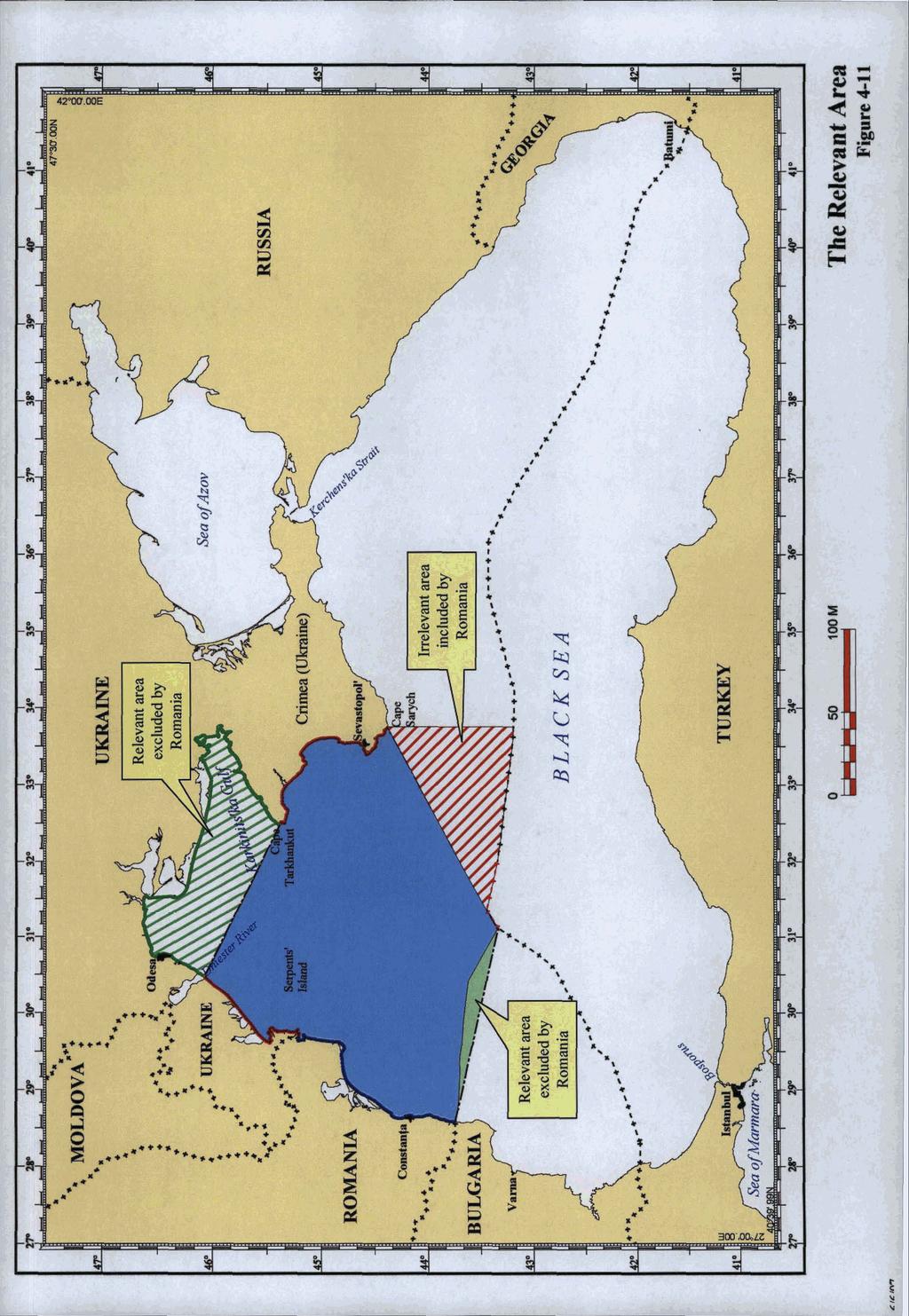
105
106 than the product of Romania's misplaced attempt to deny that Ukraine's south-facing coast comprises part of the relevant coasts of the Parties As demonstrated earlier, all of Ukraine's coast lying behind Romania's imaginary closing line generates continental shelf and Exclusive Economic Zone rights to a distance of 200 nautical miles. These entitlements extend as far south as a hypothetical boundary between Romania and Bulgaria regardless of whether such a boundary is depicted as a straight line - as Ukraine has done in defining the southern limit of the relevant area - or an equidistance line - as Romania has done Romania purports to accept the principle that the relevant area should be defined in relation to areas where there are overlapping legal entitlements - entitlements which, by definition, can only be generated by the coasts off which such areas lie.39 However, when it comes to the northern area excluded by Romania, the assertion is that as a result of the configuration of the Parties' coasts, Romania "has no entitlement to maritime zones in that zone, nor has it even made such a claim" Romania's mistake lies in equating the identification of the relevant area with the unilateral claims of one Party or the other. But the former is not dictated by the latter. In previous cases, such as Tunisia-Libya, the Court has made it clear that the relevant area is identified by reference to the coasts of the parties which abut the overall area to be delimited between them, and which do not face a third State. In Tunisia-Libya, the relevant area comprised the entire Gulf of Gabes, not because Libya's claim extended into the Gulf - which it did not - but because the Tunisian coast bordering the Gulf abutted the general area between Libya and Tunisia within which the delimitation was to be carried out As Ukraine has pointed out, all of its south-facing coast between Odessa and Cape Tarkhankut generates maritime entitlements to a distance of 200 nautical miles. Romania enjoys the same entitlements from its coasts - any overlapping entitlements being subject to delimitation. Given that the northern area excluded by Romania has no possible relevance to any third State in the region, and that it lies within 200 nautical miles of the coasts of the Parties, the area clearly comprises part of the relevant area. 39 See, for example, RR, para Ibid., para
107 B. The Eastern Triangle Which Concerns a Third State (Turkey) The second area where the Parties differ concerns a triangle of area lying south of the Crimean Peninsula between Ukraine and Turkey. This area is shaded in red on Figure 4-11, and is over 16,000 square kilometres in size. Ukraine's position is that this triangle does not form part of the relevant area because it is relevant to delimitation between Ukraine and a third State (Turkey), not to delimitation with Romania. Romania, in contrast, persists in arguing that the triangle should form part of the relevant area Romania's argument is based on the assertion that the triangle represents "overlapping entitlements of Romania and Ukraine (and of Turkey and in part of ~ul~aria)."~' Apart From the inconsistency of this argument with Romania's attempt to exclude the northern area, the contention ignores the obvious point that, even under Romania's thesis, the area in question has nothing to do with Romania because it concerns an area which is, and has been, subject to delimitation between Ukraine and Turkey This can be seen very clearly on Figure 4-1 1, which depicts the triangle in relation to the existing delimitations between Ukraine (as the successor to the Soviet Union) and Turkey, on the one hand, and between Bulgaria and Turkey, on the other Subject to agreement on its final extension to the west, the Ukraine - Turkey delimitation extends along the southern limit of the triangle for almost its entire course. The areas to the north and south of the line (the former of which includes the triangle) were obviously relevant to the delimitation between Ukraine and Turkey. Clearly, Romania has no claims in this area and, as far as Ukraine is aware, has never objected to this boundary. It follows that the areas delimited by the Ukraine-Turkey boundary, including those areas lying within the triangle, were relevant solely to the delimitation between the two States concerned and had nothing to do with Romania. 41 RR, para
108 4.80. Necessarily, therefore, these areas cannot fonn part of the area to be delimited between Ukraine and Romania, which is the subject of the present proceedings. They me not part of the "relevant area" in this case. C. The Small Sliver of Area in the South 4. S 1. The third difference between the Parties concerns a small sliver of area situated in the southwest part of the relevant area shaded in green on Figure This is a relatively minor difference given that it covers only some 2,200 square kilometres. The difference arises because Ukraine has circumscribed the relevant area by drawing a straight line fiom the land boundary betureen Romania and Bulgaria up to the location where a potential tripoint with Bulgaria andor Turkey would lie, while Romania has used an equidistance line with Buf garia as the relevant area's southern limit There is no existing delimitation between Romania and Bulgaria, whether an equidistance line or otherwise, as Romania Thus, Romania's use of an equidistance line is hypothetical. In contrast, Ukraine has used a straight line to depict the southern limit of the relevant area because this accords with the Court's past practice. For example, in the Tunisia-Libya case, the Court fixed the lateral limits of the relevant area by the use of straight lines. A similar approach was adopted in the Java Mayen case. Thus, Ukraine's position is fully in line with the Court's practice and is reasonable For all of these reasons, Ukraine continues to maintain that its identification of the relevant area is appropriate and that Romania's arguments, in particular in so far as they are directed at excluding important areas in the north, and including the "triangle" in the east, are misplaced. As for applylng the test of proportionality within this area, Ukraine will address this issue in Chapter 8.
109
110 CHAPTER 5 THE APPLICATION OF THE GEOGRAPHICAL FACTORS IN THE CONSTRUCTION OF THE PROVISIONAL EQUIDISTANCE LINE Section 1. Introduction 5.1. In its Counter-Memorial, Ukraine pointed out that it is now well settled that the process of delimitation comprises three basic steps. The first step involves the construction of a provisional equidistance line, which is a line that is equidistant from the nearest points on the baselines from which the breadth of the territorial seas of the two States is measured. The second step then involves identifying the relevant circumstances, geographic or otherwise, which characterize the area to be delimited and determining whether and to what extent those circumstances call for the adjustment of the provisional equidistance line. The third step is to test the equitableness of the result obtained by reference to the element of proportionality.' 5.2. In this Chapter, Ukraine, will revisit the basic elements involved in the construction of the provisional equidistance line. Romania accepts that this is the first step in the delimitation process. However, Romania errs in the selection of the relevant basepoints for establishing the line, and it attempts to pre-judge the relevant circumstances in constructing the line instead of assessing them independently as part of the second stage of the process. The result is a wrongly calculated provisional equidistance line and a misapplication of the law. Section 2. Selecting the Basepoints for Constructing the Provisional Equidistance Line 5.3. The selection of the relevant basepoints for constructing the provisional equidistance line should be straightforward and uncontroversial. As Ukraine explained in its Counter- Memorial, the equidistancelspecial circumstances rule for the delimitation of the continental shelf and EEZ derives from rules that have been developed since 1958 for the delimitation of I UCM, para. 7.3.
111 the territorial sea.2 Under these rules, the relevant basepoints for constructing the equidistance line are those that are equidistant from the nearest points on the baselines from which the breadth of the respective territorial seas of the Parties is mea~ured.~ This is the standard definition of a "strict" or unqualified equidistance line as employed by the Court and international tribunals - in other words, an equidistance line based on the relevant basepoints without pre-judging any particular geographic or other relevant circumstance that may subsequently justify the adjustment of the provisional equidistance line. A. The Relevant Basepoints on Ukraine's Coast 5.4. In its Counter-Memorial Ukraine described the course of the provisional equidistance line and identified the co-ordinates of the turning points on that line.4 As for the basepoints which govern the construction of the line, on the Ukrainian coast there are a series of basepoints located on Serpents' Island and one basepoint located on Cape Khersones. These are illustrated on Figure Obviously, as has been noted in Chapter 4, Serpents' Island has a coast. It follows that the outer limits of Ukraine's maritime entitlements to the south of Serpents' Island are measured from the basepoints on the low-water mark - or "normal baseline" - of the island just as the outer limits of Ukraine's maritime entitlements in the vicinity of Cape Khersones are measured from the basepoint located there. Each of these basepoints is fully appropriate for purposes of calculating the course of the provisional equidistance line Romania attempts to deny the fact that Serpents' Island provides any basepoints for establishing the provisional equidistance line. In fact, Romania goes so far as to deny that Serpents' Island even possesses a baseline capable of generating basepoints In its Reply, Romania refers to the list of geographic co-ordinates that Ukraine furnished to the United Nations on 11 November 1992 for purposes of notifying Ukraine's system of straight baselines. Romania argues that this notification includes no reference to Ibid., paras Ibid., para See Fi yre 7-1 to UCM, after page 198.
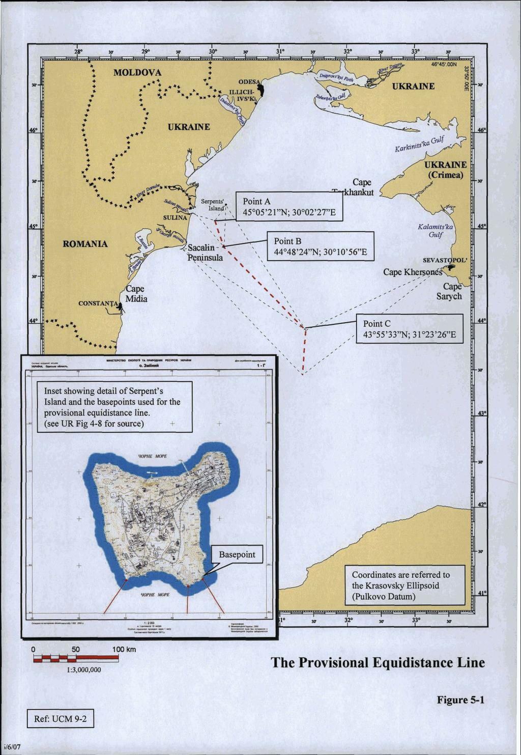
112
113 Serpents' Island, and that this means that the island is "in Ukraine's view, a basepoint that does not lie on any baseline."' 5.8. This contention is entirely without merit. It cannot seriously be argued that Serpents' Island does not possess a baseline; otherwise it would not possess a territorial sea, which even Romania acknowledges exists. That baseline is, under the provisions of Article 5 of the 1982 Convention, the "normal baseline" - in other words, the low-water mark along the coast. This was officially noted in Article 5 of Ukraine's 1991 Statute Concerning the State Frontier to which Ukraine's Counter-Memorial made referen~e.~ 5.9. It is clear that Ukraine's 1992 notification of its baselines to the United Nations was provided solely in order to notify Ukraine's system of straight baselines, not to set out Ukraine's baselines in full. Romania asserts that this characterization of Ukraine's notification is "misleading" because the notification only deals in part with a system of straight baselines and that, "in several sections the baseline follows the low-water line of the ~oast."~ Romania's contention is without object. An examination of Ukraine's notification shows that each of the numbered coordinates listed therein corresponds to the end-points of a particular straight baseline segment. To illustrate the point, Figure 5-2, overleaf, shows Ukraine's system of straight baselines bordering the relevant area with the location of each coordinate listed in the 1992 notification identified by point number Obviously, co-ordinates are only necessary - and thus were only listed in Ukraine's notification - for the points at which a straight baseline segment starts or ends. There is no need to list co-ordinates when the baseline is the "normal baseline" along the low-water mark of the coast since the low-water mark is the baseline. Indeed, to require a State to notify all of its basepoints along a normal baseline would require the listing of an infinite number of points since a normal baseline is comprised of a virtually unlimited number of basepoints. Such an exercise would make no sense. 5 RR, para See UCM, para and Annex 46, Vol RR, para
114 5.12. Equally misplaced is Romania's argument that Ukraine should have notified its baselines on Serpents' Island under Article 16 of the 1982 convention.' Article 16 provides that a coastal State should notify the co-ordinates of points, or submit large-scale charts, for baselines used for measuring the breadth of the territorial sea under Articles 7,9 and 10 of the Convention. These articles deal with straight baselines (Article 7), baselines closing the mouth of a river (Article g), and baselines closing bays (Article 1 O), respectively. Obviously, none of these applies to Ukraine's normal baselines on Serpents' Island, and thus Article 16 of the Convention is completely irrelevant It is thus clear that the reason why no basepoints were listed for Serpents' Island in Ukraine's 1992 notification was because there was no system of straight baselines on the island calling for notification, only normal baselines. It is absurd for Romania to claim that Serpents' Island is "a basepoint that does not lie on any baseline" or that it should have been included in Ukraine's 1992 notification. Serpents' Island has a baseline - the low-water mark along its coast - and thus the basepoints on that baseline are the correct basepoints to be used to plot the course of the provisional equidistance line. B. The Relevant Basepoints on Romania's Coast On the Romanian side, there are two basepoints that control the course of the provisional equidistance line. The first is situated at the end of the Sulina Dyke - a man-made feature that extends several kilometres out to sea. The second is on the seaward-most point of the Sacalin Peninsula Even though Sulina Dyke is an artificial structure that does not actually form part of Romania's coast, Ukraine has accepted that it provides one set of basepoints for the plotting of the provisional equidistance line because the Dyke forms part of Romania's baselines from which the breadth of its territorial sea is measured. This, of course, is without prejudice to whether, in the second stage of the delimitation, Sulina Dyke should be ignored as a special circumstance because of its artificial nature and the distorting effect it has on the calculation of a strict equidistance line. As Figure 4-2 to Ukraine's Counter-Memorial shows (reproduced, with different colouring, as Figure 7-1 after page 136, below), Sulina Dyke has a material S Ibid., para and footnote 7 15.

115 p>$y$ Ukraine's Straight Baselines notified to the UN in 1992 Figure 512
116 effect on the course of Romania's provisional equidistance line - a line which ignores the presence of Serpents' Island. Nonetheless, Ukraine has used the Dyke for purposes of constructing the provisional equidistance line because such a line should be based on the unqualified application of the equidistance method without pre-figuring the relevant circumstances Similarly, Ukraine has accepted that Sacalin Peninsula also provides a basepoint for constructing the provisional equidistance line despite the fact that it is a sand spit (which was previously a small island) with no human habitation or economic activity of its own. Once again, the use of the peninsula is appropriate because the outer limit of Romania's territorial sea is measured from the basepoint situated on the seaward-most projection of the feature, without prejudice to whether an uninhabited sand spit should be discounted as a special circumstance at the second stage of the delimitation Using these sets of basepoints on each Party's coast, the course of the provisional equidistance line can be readily plotted, and its course is depicted on Figure 5-1. Section 3. Romania's Biased Approach to Selecting the Relevant Basepoints A. Romania's Inappropriate Disregard of Serpents' Island Romania's construction of the provisional equidistance line is flawed by its inappropriate selection of basepoints on the Ukrainian side for the construction of the line. What Romania has done is to use the Sulina Dyke and the Sacalin Peninsula as basepoints on its own coast whilst ignoring Serpents' Island altogether despite the fact that it forms part of Ukraine's relevant coast. Apparently, Romania considers that it accords with equitable principles to employ basepoints situated on a man-made structure and a sand spit on its side while denying to Serpents' Island the same treatment. This biased approach to the plotting of the provisional equidistance line is inconsistent and methodologically wrong.
117 5.19. Romania labels its approach a "Principled Approach", but clearly it is not.9 The construction of the provisional equidistance line should be a neutral exercise based solely on the geographic facts of the case. To this end, the basepoints of each Party located on the baselines from which the breadth of each Party's territorial sea is measured are the basepoints that should be used for plotting the line. Any other method for constructing the provisional equidistance line, particularly one that arbitrarily ignores some basepoints in favour of others, runs counter to the law because it involves pre-judging the effect that particular geographic factors may play as potential special or relevant circumstances In other words, the first stage of the delimitation should be 'delimitation neutral' in the sense that it involves constructing a strict equidistance line from the respective basepoints on each Party's baseline. It is only at the second stage - the stage at which the relevant circumstances are identified and assessed - that the question arises whether particular geographic or other circumstances call for the adjustment of the provisional equidistance line Romania recognizes this as a matter of principle, but then fails to follow a principled approach. For example, Romania states in its Reply that: "The delimitation of the maritime zones beyond the territorial sea is a two stage process: the now well-established method 'involves first drawing an equidistance line, then considering whether there are factors calling for the adjustment or shifting of that line in order to achieve an 'equitable result". In other words, the relevant circumstances come after a line has first been drawn according to the principle of equidistance."' Romania also cites with approval the Court's pronouncement in the Jan Mayen case that: "[...l special circumstances are those circumstances which might modify the result produced by an unqualified application of the equidistance principle. General international law, as it has developed through the case-law of the Court and arbitral jurisprudence, and through the work of the Third United Nations Conference on the Law of the Sea, has employed the concept of 'relevant circumstances'. This concept 9 RR, p Ibid., para. 6.5, citing Maritime Delimitation and Territorial Questions between Qatar and Bahrain (Qatar v. Bahrain), I. C. J. Reports 2001, p. 40, at p. 104, para
118 can be described as a fact necessary to be taken into account in the delimitation ' ~ This principle was also adopted by the Court of Arbitration in the Anglo-French Arbitration which held: "In the absence of agreement, and unless another boundary is justified by special circumstances, the boundary is to be the line which is equidistant from the nearest points of the baselines from which the breadth of the territorial sea of each State is measured. " ' * i It follows that the provisional equidistance line should be established on the basis of a strict equidistance line before any relevant circumstances are considered. The relevant circumstances only come into play at the second stage of the delimitation exercise. By arbitrarily excluding the relevant basepoints on the coast of Serpents' Island at the first stage of the process, Romania's methodology is based on a flawed foundation, and misapplies the law. B. Romania's Flawed Contention that Serpents' Island Is a Relevant Circumstance Further evidence of Romania's misguided approach appears from Romania's characterisation of Serpents' Island as a special, or relevant, circumstance." While Chapter 6 will discuss the relevant circumstances in more detail, it is appropriate to point out that the fact that Romania labels Serpents' Island a special or relevant circumstance underscores the point that Serpents' Island should have been considered by Romania only at the second stage of the delimitation process after the provisional equidistance line had been established and I I Maritime Delimitation in the Area befween Greenland and Jan Mayen (Denmark v. Norway, I.C.J. Reports 1993, p. 38, at p. 62, para. 55. Case Concerning the Delimitation of the Continental Shelf between the United Kingdom of Great Britain and Northern Ireland and the French Republic, decision of 18 June 1977, reprinted in RIAA, Vol. XVIII, at p. 111, para Romania argues in its Reply that this case is not relevant because the Scilly Islands bear no resemblance to the circumstances of the present case (RR, para. 8.18). But, once again, Romania coduses the role of special or relevant circumstances at the second stage of the delimitation with the construction of the provisional equidistance line at the fust stage. The Court of Arbitration posited a strict, or unqualified, equidistance line as a fust step in the delimitation, and only in a second stage, then adjusted that line to take into account the presence of the Scilly Islands. See, for example, RR at para. 6.2 where Romania asserts that Serpents' Island is "the most important special circumstance", and at p. 194 where Romania labels one of its sections "Serpents' Island as a relevant circumstance."
119 that the basepoints situated on Serpents' Island should have been used for constructing the provisional line Romania admits as much when it states that the relevant circumstances should only be taken into account "after a line has first been drawn according to the principle of equidistance."'4 If this is so, and if Romania wishes to argue that Serpents' Island is a relevant or special circumstance that should be given a reduced effect, then the place to do this is at the second stage, not by pre-judging the issue for purposes of plotting the course of the provisional equidistance line itself Of course, to the extent that Romania considers Serpents' Island to be a relevant circumstance, it must also take into account the dominant geographic circumstance characterizing the area to be delimited, which is the substantial disparity in the overall lengths of the coasts of the Parties abutting the area to be delimited. As Chapters 6 and 7 will show, Ukraine has taken this key factor into account, and has shown how and why the provisional equidistance line should be adjusted to give proper weight to this circumstance. Section 4. Conclusion For present purposes, the construction of the provisional equidistance line should be drawn from the nearest basepoints on each Party's baselines from which the territorial sea is measured, without prejudice to the effect that any relevant circumstances may have in the adjustment of that line. Figure 5-1 shows the course of such a line and the basepoints that have been used for its construction. I,, I4 I RR, paras. 6.3 and 6.5.
120 CHAPTER 6 THE IDENTIFICATION OF THE RELEVANT CIRCUMSTANCES Section 1. Introduction 6.1. Both Parties acknowledge that the "relevant circumstances" characterizing the area to be delimited play a critical role in the delimitation. However, Romania's Reply continues to take a confused approach to the identification and assessment of the relevant circumstances, particularly the importance of the coastal geography and the substantial disparity that exists between the length of the Parties' coasts fronting the area as a circumstance calling for an adjustment of the provisional equidistance line While Romania's Memorial took the position that the only relevant circumstances in the case were the enclosed nature of the Black Sea and third party delimitations agreed therein, its Reply now includes Serpents' Island as a relevant or, as Romania terms it, "special" circumstance. Moreover, while previously paying lip service to the importance of the geographical factors - indeed, Romania's Memorial acknowledged that the "primary" factor "is the geographical situation of the area to be delimited, i.e., its configuration," and that this includes "the projection of the relevant coasts" - Romania's Reply contains a section entitled the "Irrelevance of 'Geographical Factors"' as special circumstances.' 6.3. In this Chapter, Ukraine will first deal with Romania's contention that the "enclosed nature of the Black Sea" and existing Black Sea delimitation agreements are relevant for purposes of carrying out the delimitation between Ukraine and Romania (Section 2). Thereafter, Ukraine will turn to the relevant circumstances in the case. These are primarily the geographical factors, including the relevant coasts of the Parties, which demonstrate the geographical predominance of Ukraine in the area to be delimited (Section 3). However, they also include the State activities of the Parties, whch, as Ukraine will show, are fundamentally in contradiction with Romania's delimitation claim (Section 4). I RM, at p. 191.
121
122 6.8. These arguments were comprehensively rebutted in Ukraine's counter-~emorial.~ 6.9. With regard to the TurkeyNSSR and TurkeyIBulgaria delimitation agreements, Ukraine pointed out that Romania's interpretation of these treaties to imply a recognition by third States that Romania enjoyed entitlements to maritime areas up to or beyond certain points was incorrect. In these treaties, the parties agreed maritime boundaries up until certain defined points, but included provisions envisaging an eventual extension of the respective maritime boundaries at a later, "c~nvenient"'~ or "suitable"," time As was stated in Ukraine's Counter-Memorial, these agreements are only relevant in that they inform the Court of maritime areas to which third States lay claim, thereby enabling the Court to confine its decision in the present case to areas in which neither Bulgaria nor Turkey have claims to continental shelf or an EEZ." However, these agreements cannot be construed as somehow constituting third party recognition that Romania's claims in this case are valid, as Romania has argued As to the correct interpretation of the content of the TurkeytUSSR and TurkeyBulgaria agreements, it appears from its Reply that Romania does not take issue with the analysis presented at paragraphs (regarding the Turkey/USSR agreements) and at paragraphs (regarding the TurkeyIBulgaria agreement) of Ukraine's Counter- Memorial. In particular, the fact that neither agreement can be construed as an acknowledgement on the part of the USSR, Turkey or Bulgaria that Romania had a valid claim up until or beyond any point referenced in either treaty was not rebutted by Romania Likewise, it appears from Chapter 6, Section D of its Reply that Romania does not take issue with Ukraine's observation that these agreements only constitute a relevant circumstance to the extent that the Court should take them into account to ensure that the delimitation line between Ukraine and Romania does not infringe on areas claimed by neighbouring States. This general principle was expounded in clear terms in the Judgment of 9 10 I I 12 See UCM, paras ("Romania's 'Enclosed Sea' Argument") and ("Third State Delimitations in the Black Sea"). See Article 1 of the TurkeyIUSSR agreement on the continental shelf, UCM, Annex 17, Vol. 2. See Article 4(1) of the TurkeylBulgaria agreement, UCM, Annex 18, Vol. 2. UCM, paras ,
123 the International Court of Justice in Libya-Malta where the Court held that "[tlhe decision of the Court must be confined to the area in which, as the Court has been informed by Italy, that State has no claims to continental shelf rights." In the present case, neither Bulgaria nor Turkey have applied to intervene in the proceedings. However, the Court is informed of the extent of the areas of continental shelf/eez to which either of these two States have laid claim by virtue of the fact that this is reflected in the respective treaties As to Romania's second argument, namely its position that the "enclosed nature" of the Black Sea is a relevant circumstance, Ukraine emphasised in its Counter-Memorial that there is no legal authority, deriving from the 1982 Convention or otherwise, supporting Romania's argument that the fact that Romania and Ukraine border an "enclosed sea" within the meaning of Article 122 of the 1982 Convention constitutes a special or relevant circumstance for purposes of deciding upon the appropriate method of delimitation in thls case.14 In particular, there is no basis for Romania's argument that the Court should ignore the fact that the relevant coast of Ukraine is substantially longer than that of Romania since, according to Romania, the respective lengths of the parties' coasts were not taken into account in the TurkeyNSSR and the TurkeyfBulgaria agreements It is true, as Ukraine pointed out in its Counter-Memorial, that in the course of the negotiations leading up to the 1982 Convention, Romania made a proposal that the delimitation of the continental shelf and Exclusive Economic Zones of States bordering semienclosed seas should be effected under a separate regime.'' However, these proposals were not accepted, and consequently are not reflected in the agreed text of the 1982 Convention. This fact underscores the absence of a legal basis for Romania's contention that the fact that the Black Sea is an enclosed or semi-enclosed sea is relevant to determining the method to be adopted in the delimitation of Ukraine's and Romania's continental shelf and Exclusive Economic Zones. 13 Continental Shelf (Libyan Arab Jamahiriya/Malta), Judgment, I.C.J. Reports 1985, p. 13, at p. 26, para UCM, paras I S The proposal made by Romania and other States on 22 June 1977 is recorded at R. Platzoder, Third United Nations Conference on the Law of the Sea, Documents, Dobbs Ferry, NY, Oceana, 1982, Vol. ]V, p The informal suggestion made on 1 September 1978 is at U.N. Document C.2Anfomal Meeting11 8/Rev. l.
124 6.16. As discussed in Ukraine's Counter-Memorial, the fallacy of Romania's argument that the enclosed nature of the Black Sea is a relevant circumstance is also demonstrated by a review of the judgments of the Court concerning maritime delimitations between States bordering on the Mediterranean Sea, a semi-enclosed sea. As was discussed by Ukraine, and as is accepted by Romania, the delimitation methods adopted by the Court in the Tunisia- Libya and Libya-Malta cases were based on the relevant circumstance existing as between the parties to those cases.16 In neither case was the semirenclosed nature of the Mediterranean Sea cited as a relevant circumstance determining the method of delimitation to be adopted, and in the Libya-Malta case the Court did not feel obliged to utilise the delimitation method followed by the Court in the Tunisia-Libya case, nor did it feel restricted by methods employed by other Mediterranean States in their bilateral delimitation agreements in arriving at its decision.i The fundamental problem with Romania's "enclosed sea" argument is clear if the purpose of Romania's argument is considered. As noted above, Romania assumes that in respect of the TurkeyKJSSR and the TurkeyIBulgaria agreements the respective parties' relevant coasts were disproportionate, but that the difference in lengths of their coasts was not considered relevant for purposes of the delimitation. This is completely speculative, and represents no more than another attempt by Romania to develop an argument that the Court should ignore the geography of the relevant area, and not take into account the fact that the length of Ukraine's relevant coast is some four-times longer than that of Romania As will be discussed in the next Section, Romania's position runs contrary to accepted principles of international law on maritime delimitation as articulated in the decisions of this Court. As Ukraine pointed out in the Counter-Memorial with arguments that remain essentially unrebutted, Romania is effectively attempting to invoke treaties between third States in order to subvert Ukraine's entitlements under international law. Aside from the dubious basis of Romania's supposition that the relevant coasts of TurkeyKJSSR and See UCM, paras For example, the Agreement between Greece and Italy on the delimitation of their Zones of Continental Shelf signed on 24 May 1977, J.I. Charney and L.M. Alexander (Ed.), International Maritime Boundaries, Martinus Nijhoff Publishers, Dordrecht/Boston/London, 1993, Volume 11, pp , and the Agreement between Italy and Spain relating to the Delimitation of the Continental Shelf between the Two Countries signed on 19 February 1974, in J.I. Charney and L.M. Alexander (Ed.), International Maritime Boundaries, 1993, Volume 11, pp
125 TurkeyIBulgaria were disproportionate in the context of the delimitations agreed by those ~tates,'~ the legal basis for Romania's argument that, on the basis of these two treaties, the disproportionate lengths of Ukraine's and Romania's relevant coasts should be ignored is clearly absent From a review of its Reply, it is unclear to what extent Romania maintains its argument that, due to the enclosed nature of the Black Sea, the alleged failure by third parties to have taken into account hypothetical disproportionate coastal lengths in the TurkeyNSSR and the TurkeyIBulgaria agreements should dictate how the delimitation between Romania and Ukraine should be achieved Having cited the Libya-Malta judgment to the effect that "[iln a semi-enclosed sea like the Mediterranean [...l reference to neighbouring States is particularly apposite [...l", Romania then stated in its Reply that "[tlhis conclusion might not be applicable to all delimitations to be effected in enclosed or semi-enclosed sea^".'^ In the light of this, Romania appears to acknowledge that the fact that the Black Sea is an enclosed or semi-enclosed sea is not per se a relevant circumstance. As mentioned above, both Parties also appear to agree that the location of third State claims should be taken into account only in order to ensure that the delimitation line does not inhnge on areas claimed by third States. In an enclosed or semienclosed sea, it is frequently the case that maritime areas appertaining to the littoral States encroach upon each other. This is the case in the Mediterranean Sea - hence the comment of the Court in Libya-Malta - but it does not follow that the enclosed nature of the Black Sea in and of itself is a relevant circumstance which should determine the method of delimitation to be adopted in this case. It was not a relevant circumstance affecting the method of delimitation decided by the Court in either the Tunisia-Libya or Libya-Malta cases, and it is not a relevant circumstance here. I8 19 Contrary to Romania's implication, the coasts of the USSR and Turkey facing the area delimited in the 1978 Agreement would appear to be of comparable length. Similarly, although Turkey's coast, if measured up until the border with Georgia, is obviously longer than that of Bulgaria, it appears that the relevant coasts of the two States, i.e., the coasts facing the area delimited in the 1997 Turkey-Bulgaria Agreement, are not disproportionate. It is noteworthy that Romania has been unable to point to any commentary indicating that there was a disproportionality of coastal lengths which was ignored. RR, para
126 P- P In an apparent shift of position, Romania's Reply introduces a new argument under the rubric of the "enclosed character of the Black Sea" to the effect that, if Serpents' Island is used as a basepoint, this would not only involve the generation of a "coastal projection without a coast in support", but that the "east-facing coastline of Romania [would be] caught in a virtually concave position, to its great di~advanta~e".~' Romania therefore argues that Serpents' Island should be ignored as a basepoint since, otherwise, assuming that a maritime boundary will be agreed with Bulgaria on the basis of equidistance, as is depicted on Figure RR25 at page 206 of Romania's Reply, Romania would be unfairly disadvantaged. Recalling the decision of the Court in the North Sea Continental Shelfcases and of the arbitral tribunal in Guinea/Guinea - Bissau, Romania submits that this would produce an inequitable result and that this is a further reason why the Court should accept Romania's proposed claim line As to this new argument, it should first be noted that Romania relies neither on the enclosed nature of the Black Sea nor on any delimitations between third States in advancing its proposition. Romania's focus is rather on the western part of the Black Sea and on a hypothetical delimitation line between Romania and Bulgaria. Accordingly, this argument appears to bear little relation to the rest of Romania's arguments contained in Chapter 6, Section D or to the title of this section ("The Black Sea as an Enclosed Sea and the Existing Delimitation Agreements in the Black Sea"). Indeed, it is remarkable that Romania bases its argument on the hypothetical location of a maritime boundary between Romania and a third State which has never been delimited. The fact that this argument is based in part on the possible location of a boundary that has not been delimited (and in respect of which Romania has filed no evidence as to the status of the negotiations) undermines the relevance of Romania's argument Second, there is no concavity in the coast extending from Odessa to Bulgaria. As discussed in Chapter 3 of Ukraine's Counter-Memorial, the western coast of the Black Sea follows a general southwest-northeast direction from the Turkish-Bulgarian border up until a point near Odessa, and any concavity existing east of Odessa involves coasts that are 20 RR, para
127 exclusively Ukrainian. The geographical characteristics of areas at issue in the cases cited by Romania were quite different. In both cases, the coasts extending on either side of the area to be delimited were characterised by concavity, with the result that the use of the equidistance method would have resulted in Germany and Guinea being enclaved due to the location of those States between, respectively, Denmark and The Netherlands, and Guinea-Bissau and Sierra Leone. It was due to the absence of concavity in the stretch of coastline focussed on by Romania that Romania was obliged to invent a "virtual" coastline linking Serpent's Island and Cape Khersones. The fact that Romania has been obliged to rely on a non-existent "virtual" coastline, again, undermines its argument Obviously, Romania and Ukraine border on the Black Sea, which is enclosed, with the result that the projections of the Parties' coasts (along with those of other littoral States, such as Bulgaria and Turkey) inevitably converge. But this fact, if anything, distinguishes the present case from the North Sea Continental Shelf Cases and Guinea/Guinea - Bissau. In those cases, the parties' coasts projected onto open maritime areas (the North Sea, where the United Kingdom's continental shelf represented the limit of the parties' maritime entitlements, and the Atlantic Ocean). This is reflected particularly in the award in Guinea/Guinea - Bissau where the Tribunal noted that "[wlhen in fact - as is the case here, if Sierra Leone is taken into consideration - there are three adjacent States along a concave coastline, the equidistance method has the other drawback of resulting in the middle country being enclaved by the other two and thus prevented from extending its maritime territory as far seaward as international law provides".2' In the Black Sea, no State enjoys a 200 nautical mile. Continental Shelf or Exclusive Economic Zone, and a degree of converging of maritime areas of the littoral States is inevitable - all States are thus prevented from extending their maritime areas as far seaward as international law provides. r - * Third, and most significantly, it needs to be emphasised that here again Romania ignores the geography of the relevant area and proceeds on the assumption that the coasts of Ukraine and Romania facing the relevant area are of similar lengths. Romania's reliance on the decisions in the North Sea Continental Shelf Cases and in Guinea/Guinea - Bissau is premised on the fiction that the Crimea is in effect an island and that some 630 kilometres of 21 Arbitral Tribunal for the Delimitation of the Maritime Boundary between Guinea and Guinea-Bissau, Award of 14 February 1985,25 ILM, Volume XXV, No. 2, p. 295, para. 104.
128 Ukrainian coastline which abut the area to be delimited simply do not exist (as depicted on Figure 3-3 to Ukraine's Counter-Memorial) As discussed in Chapter 4, there is a significant disparity between the coastal lengths of Romania and Ukraine which front the relevant area, and this disparity is the salient characteristic of the geography of the region. There was no such disparity between the lengths of the North Sea-facing coasts of Denmark, Germany and The Netherlands, nor was there any such disparity between the coasts of Guinea and Guinea - Bissau In the light of this, Romania's reliance on the North Sea Continental Shelf Cases is unavailing. In those cases (in which the Court ruled in favour of the application of equitable principles as opposed to equidistance), the Court stated: "Equity does not necessarily imply equality. There can never be any question of completely refashioning nature, and equity does not require that a State without access to the sea should be allotted an area of continental shelf, any more than there could be a question of rendering the situation of a State with an extensive coastline similar to that of a State with a restricted coastline. Equality is to be reckoned within the same plane, and it is not such natural inequalities as these that equity could remedy. But in the present case there are three States whose North Sea coastlines are in fact comparable in length and which, therefore, have been given broadly equal treatment by nature except that the configuration of one of the coastlines would, if the equidistance method is used, deny to one of these States treatment equal or comparable to that given the other In the present proceedings, Romania attempts to render the situation of a State with an extensive coastline (Ukraine) similar to that of a State with a restricted coastline (Romania). Romania's submissions in this respect must be rejected Finally, it is relevant to recall that this Court, as well as arbitral tribunals, have been unwilling to accept submissions relying on the finding of the tribunal in Guinea/Guinea - Bissau regarding the concavity of the relevant coastline and the location of third States. For example, in Cameroon-Nigeria Carneroon contended that "the concavity of the Gulf of Guinea in general, and of Cameroon's coastline in particular, creates a virtual enclavement of 22 North Sea Continental Shelf Cases, Judgment, I. C.J. Reports 1969, p. 3 at pp , para. 9 1
129 ~arneroon".~~ This argument was rejected since the concavity of Cameroon's coastline was apparent primarily in the sector where it faced, not the area to be delimited with Nigeria, but an area which faced a third State, Equatorial ~uinea.~~ It was not the Court's task to compensate Cameroon for any perceived disadvantages suffered by it due to the geography of the area taken as a whole In the 2006 Trinidad and Tobago/Barbados arbitration, Trinidad and Tobago relied on Guinea/Guinea-Bissau in arguing that the delimitations between Trinidad and Tobago and Venezuela in the south, and between ~rance (Guadeloupe and Martinique) and Dominica in the north, should be taken into account by the Arbitral Tribunal In the Award rendered in that arbitration, the Tribunal rejected Trinidad and Tobago's arguments that these "regional considerations" should be taken into account. The argument as to the relevance of the FranceIDominica delimitation agreement was dismissed since "[ilt [had] no connection at all to the present dispute, direct or indire~t".~' As regards the Trinidad and TobagoNenezuela agreement, the Tribunal observed that "[tlhe treaty is quite evidently res inter alios ncta in respect of Barbados and every other country."26 The Tribunal then added that, since Trinidad and Tobago had agreed on the limit of its area of continental sheli7eez in the 1990 Agreement with Venezuela, the Tribunal should take this fact into account so as not to draw a delimitation line which would attribute to Trinidad and Tobago areas that it did not claim. l l i l I To summarise, Romania has established no reason why the enclosed nature of the Black Sea or the delimitation agreements already concluded by Black Sea littoral States constitute relevant circumstances in this case or should have any influence on the location of the maritime boundary between the Parties except insofar as they may indicate how far seaward the delimitation may extend. The only possible relevance of the TurkeyIUSSR and Turkey/Bulgaria agreements is that they inform the Court as to the location of potential third State claims in the general area. 23 I Land and Maritime Boundary between Cameroon and Nigeria (Cameroon v. Nigeria: Equatorial I Guinea intervening), Judgment, I.C.J. Reports 2002, p. 303, at p. 445, para Ibid., para I 25 I In the Matter of an Arbitration Between Barbados and the Republic of Trinidad, Award of 11 April 2006,451 ILM 800 (2006), at p. 854, para l 26 I Ibid., p. 346.
130 Regarding Romania's argument that it threatens being disadvantaged by the presumed location of a hture BulgaridRornania maritime boundary, this must be dismissed for several reasons. Romania assumes the future location of this boundary, but has filed no evidence regarding its negotiations with Bulgaria to justify this assumption. Moreover, the Romanian argument ignores the geography of the area relevant to the delimitation between the Parties to this case, and is based on the fiction that hundreds of kilometres of Ukrainian coastline do not exist. As the Court has consistently maintained, it is not the task of the Court to invoke equity to refashion the geographical facts. Section 3. The Coastal Geography ss a Relevant Circumstance A. Applicable Legal Principles In considering the role that the coastal geography plays in establishing an equitable delimitation, it is appropriate to start with a review of a number of basic principles. The first point is that it is axiomatic, as the Court stated in the TunisidLibya case, that "[tlhe geographic correlation between coast and submerged areas off the coast is the basis of the coastal State's legal title."27 It is for this reason that the Court held: "The coast of each of the Parties, therefore, constitutes the starting line from which one has to set out in order to ascertain how far the submarine areas appertaining to each of them extend in a seaward direction, as well as in relation to neighbouring States situated either in an adjacent or opposite position." While these statements of principle were made in the context of a case involving continental shelf delimitation, the importance of geographical factors - particularly the coastal geography of the States concerned - is even more pronounced in situations where the Court is requested to establish a single maritime boundary as it is here. As the Chamber of the Court noted in the GuyofMaine case (which involved a single maritime boundary): Conlineniul Shelf (TunisidLibyan drab Jamahiriya), Judgment, I. C.J. Reports 1982, p. 18, at p. 6 1, para. 73. Ibid., at p. 61, para. 74.
131 "it is, accordingly, towards an application to the present case of criteria more especially derived from geography that it feels bound to turn. What is here understood by geography is of course mainly the geography of coasts, which has prirnasiiy a physical aspect, to which may be added, in the second place, a political aspect."2g In the light of the Court's jurisprudence, it is astonishing to find that Romania's Reply takes the position that the "geographical factors" of the case - namely, the geography of the coasts of the Parties - are irrelevant. Romania's misconception of basic legal principles is compounded by the fact that Romania fundamentally confuses the role that coastal geography plays - especially in situations where there is large disparity in the lengths of the Parties' coasts abutting the relevant area - as a relevant circumstance to be taken into account at the second stage of the delimitation process after the provisional equidistance line has first been established, with the application of the p~oportionality test which is only employed at the third stage of the process to test the equitableness of the result obtained horn the first hvo steps The confusion exhibited by Romania's Reply in this respect is illustrated by the following passage taken from the Reply: "Nor do the respective lengths of the relevant coasts of the Parties constitute 'relevant circumstances'. As explained above, proportionality can be taken into account if the line resulting from the application of the equidis tance/spetsial circumstances principle results in a situation 'in which the relationship between the length of the relevant coasts and the maritime areas generated by them by application of the equidistance method, is so disproportionate that it has been found necessary to take this circumstance into account to ensure an equitable sofution'. It is appropriate to deal with proportionality only after having identified the line resulting from the application of the qui table principles/special circumstances approach. " This line of reasoning runs contrary to the Court's well-established jurisprudence which has consistently held that a mmked disparity in the lengths of the parties' coasts is a relevant circumstance justi fyng an adjustment of the provisional equidistance line, and that this step of the delimitation process is separate and distinct hm a consideration of proportionality, which is an ex post facto test. 29 Delimttation of fhe Maritime Boundary in the Gulf of Maine Area, Judgntenl, I. C.9. Reports 1984, p. 246, at p. 327, para RR, para (footnotes not included).
132 6.40. To appreciate the ill-founded nature of Romania's thesis, reference may first be made to the Judgment in the Gulf of Maine case where the Chamber of the Court explained the position in the following way: "The Chamber's views on this subject may be summed up by obseniing that a maritime delimitation can certainly not be established by a direct division of the area in dispute proportional to the respective lengths of the coasts belonging to the parties in the relevant area, but it is equally certain that a substantial disproportion to the lengths of those coasts that resulted from a delimitation effected on a different basis would constitute a circumstance calling for an appropriate c~rrection."~' The Court further distinguished the relationship between differences in coastal lengths as a relevant circumstance, and the role of coastal lengths as part of the proportionality test, in its Judgment in the Libya/Malta case. There, the Court differentiated these two aspects of the delimitation exercise with considerable clarity. With respect to the application of the proportionality test based on ratios between lengths of coasts and areas of continental shelf attributed to those coasts, the Court stated the following: "It has been emphasised that this latter operation [application of proportionality] is to be employed solely as a verification of the equitableness of the result amved at by other means However, the Court then went on to say that a marked difference in coastal lengths was also a relevant circumstance to be taken into account independently. As the Court explained: "It is however one thing to employ proportionality calculations to check a result; it is another thing to take note, in the course of the delimitation process, of the existence of a very marked difference in coastal lengths, and to attribute the appropriate significance to that coastal relationship, without seeking to define it in quantitative terms which are only suited to the expost assessment of relationships of coast to area. The two operations are neither mutually exclusive, nor so closely identified with each other that the one would necessarily render the other supererogatory. Consideration of the comparability or otherwise of the coastal lengths is a part of the process of determining an equitable boundary on the basis of an initial median line; the test of a Delimitation of the Maritime Boundary in the Gulf of Maine Area, Judgment, I.C.J. Reports 1984, p. 246, at p. 323, para Continental Shelf (Libyan Arab JamahiriydMalta), Judgment, I.C.J. Reports 1985, p. 13, at p. 49, para. 66.
133 reasonable degree of proportionality, on the other hand, is one which can be applied to check the equitableness of any line, whatever the method used to arrive at that line." Based on this reasoning, the Court in Libya/Malta adjusted the provisional equidistance line northwards to take into account as a relevant circumstance the longer Libyan coast that abutted the area to be delimited. Given the particular geographic context of that case, the Court did not deem it necessary to apply the proportionality test thereafter A similar approach was adopted by the Court in the Greenland-Jan Mayen case where, once again, the Court was faced with a situation where there was a marked disparity in the length of the coasts of the parties which bordered the delimitation area. This difference in coastal lengths constituted a relevant circumstance calling for a substantial adjustment of the provisional equidistance line. The Court explained the position as follows:! l "There are however situations - and the present case is one such - in which the relationship between the length of the relevant coasts and the maritime areas generated by them by application of the equidistance method, is so disproportionate that it has been found necessary to take this circumstance into account in order to ensure an equitable solution." After noting that, in the Gulf of Maine case, the Chamber considered that a coastal ratio of 1 to 1.38 was suficient to. justify a "correction" of a median line operation, the Court in Greenland-Jan Mayen found that the disparity that existed in that case also constituted a special circumstance to be taken into account. In the Court's words: "It follows that, in the light of the disparity of coastal lengths, the median line should be adjusted or shifted in such a way as to effect a delimitation closer to the coast of Jan ~ a~en. " The recent Award in the Barbados-Trinidad and Tobago arbitration is hlly in line with the Court's jurisprudence. As the Tribunal in that case observed: Ibid. Maritime Delimitation in the Area Between Greenland and Jan Mayen, Judgment, I.C.J. Reports 1993,. p. 38, at p. 67, para. 65. Ibid., p. 69, para. 69.
134 "The Tribunal finds no difficulty in concluding that coastal frontages are a circumstance relevant to delimitation and that their relative lengths may require an adjustment of the provisional equidistance line." In keeping with the Court's precedents, the Tribunal noted that the taking into account of differences in coastal lengths did not require the drawing of a delimitation line in a mathematical way determined by exact coastal ratios. Rather, the Tribunal stated that: "The degree of adjustment called for by any given disparity in coastal lengths is a matter for the Tribunal's judgment in the light of all the circumstances of the case.")' The Tribunal also noted the difference that exists between relying on basepoints, which are technically identifiable and have a role in the drawing of the provisional equidistance line, and taking into account coastal frontages which "are not strictly a function of the location of basepoints, because the influence of coastlines upon delimitation results not from the mathematical ratios discussed above or from their contribution of basepoints to the drawing of an equidistance line, but from their significance in attaining an equitable and reasonable outcome, which is a much broader c~nsideration."~~ From the foregoing, it is clear that Romania's attempt to deny that differences in coastal lengths are a relevant circumstance justifying an adjustment of the provisional equidistance line is misplaced. A material difference in coastal lengths is a relevant circumstance and, given the facts in this case, this circumstance clearly calls for a shifting of the provisional equidistance line in order to produce an equitable result. B. The Geographical Predominance of Ukraine in the Relevant Area Ukraine's Counter-Memorial explained in detail the geographical predominance of Ukraine within and around the relevant area.39 This predominance manifests itself in two main ways. 36 In the Matter of an Arbitration between Barbados v. The Republic of Trinidad and Tobago, Award of l l April 2006, 45 ILM 800 (2006), p. 852, para. 327, citing the GulfofMaine, Libya/Malta and Jan Mayen cases. 37 Ibid., at p. 852, para Ibid., para UCM, paras
135 6.50. First, the coast of Ukraine fronts the relevant area on three sides: on the west from the terminal point on the land boundary with Romania up to Odessa; on the north from Odessa to the Karkinits'ka Gulf, and on the east along the coast of Crimea as far south as Cape Sarych. In contrast, Romania's coast only fronts the relevant area along a short stretch in the west. Thus, the relevant area is circumscribed primarily by the coasts of Ukraine, which constitute most of the coast along the gulf-like feature which characterizes the northwest region of the Black Sea Second, the coast of Ukraine fionting the relevant area measures some 1,058 kilometres while the coast of Romania measures only some 258 kilometres. As Ukraine has pointed out, this represents a difference in coastal lengths in the range of 4.1 to 1 in favour of ~kraine.~' The Court's jurisprudence referred to in the preceding section makes it clear that disparities in coastal lengths of this magnitude constitute a relevant circumstance calling for the adjustment of the provisional equidistance line. As previously noted, even a much more modest difference in coastal lengths in the Gulf of Maine case (where the ratio was in the order of 1.38 to 1) justified a shifting of the equidistance line in favour of the State with the longer coast. A fortiori, a coastal difference of over 4 to 1 constitutes a relevant circumstance also calling for a significant adjustment of the provisional equidistance line in this case Ukraine recognizes that delimitation is not to be camed out on the basis of strict mathematical ratios. As the following Chapter will show, Ukraine's delimitation line is not derived from a mathematical division of the relevant area based on coastal ratios. Nonetheless, the fact remains that there is a marked disparity in the lengths of the Parties' coasts fionting the area to be delimited, and this circumstance needs to be taken into account at the second stage of the delimitation process by making an appropriate adjustment to the provisional equidistance line. 40 UCM, para
136 6.54. Viewed in this perspective, it becomes apparent why Romania takes the position that the geographical factors characterizing the area are irrelevant and that the respective lengths of the coasts of the Parties do not constitute "relevant circumstance^."^' But for Romania to deny the reality of the coastal geography and its role in the delimitation process is to deny the geographic facts as they exist and to disregard the Court's jurisprudence which has consistently held that significant differences in coastal lengths are relevant In Chapter 4 of this Rejoinder, as well as in Chapter 3 of the Counter-Memorial, Ukraine discussed the coastal geography of the Parties. Ukraine does not propose to recanvass the issue here. In considering the relevance of the geographic facts, however, it is appropriate to note that Romania appears to lack confidence in its argument that differences in coastal lengths are irrelevant. Clearly, Romania is concerned about this aspect of the case, and it is for this reason that elsewhere in its Reply Romania has tried to shorten Ukraine's relevant coast by eliminating over 600 kilometres of that coast from consideration (the entire south-facing coast of Ukraine). Why would Romania advance such an argument if it genuinely considered differences in coastal lengths to be irrelevant? As explained in Chapter 4, Romania's attempt to refashion geography by eliminating a long stretch of Ukraine's coast is misconceived. All of Ukraine's coast bordering the area to be delimited generates maritime entitlements out to 200 nautical miles - in other words, throughout the relevant area. Given that Ukraine's coast does not face any third State in this area, and that the maritime entitlements that Ukraine's coast gives rise to overlap with the potential entitlements of Romania, all of Ukraine's coast is no less relevant to the delimitation than the coast of Romania. To the extent that there is a marked difference in the coastal lengths of the Parties in the area - which there clearly is - the principles of maritime delimitation dictate that such a difference should be treated as a relevant circumstance justifying a shifting of the provisional equidistance line. The way such an adjustment has been reflected by Ukraine in its delimitation line is discussed in the next Chapter. 41 RR, para. 6.12
137 C. The Relevance of Serpents' Island for the Delimitation In its Memorial, Romania contended that the only relevant circumstance in the case is the enclosed nature of the Black Sea and that there were no relevant circumstances justifjmg a departure fiom the provisional equidistance line.42 In its Reply, however, Romania has changed its position and has argued that there are actually two relevant, or "special" circumstances. One of these is still said to be the enclosed character of the Black Sea. The other is claimed to be "the presence, off the coasts of the Parties, of Serpents' ~sland."~~ In the light of this shift of position, it is necessary to discuss the relevance of Serpents' Island for the present case The first point to note is that Romania adopts a decidedly inconsistent posture with respect to Serpents' Island. On the one hand, Romania's Reply cites a number of examples drawn from judicial precedents and State practice to support its argument that Serpents' Island is an insignificant feature which is entitled to no continental shelf or Exclusive Economic Zone, only a 12-mile belt of territorial sea. On the other hand, and in addition to the extensive discussion about Serpents' Island contained in Romania's Memorial, the Reply devotes an entire chapter (Chapter 5) and an Addendum to an analysis of the island's history and status. Suffice is to note that, for such an allegedly "insignificant" island, an enormous amount of historical source material devoted to the Island exists and has been referred to by the Parties. Whatever its size, Serpents' Island has commanded considerable attention throughout history Notwithstanding this, it is important to place Serpents' Island in its proper context within the overall fi-amework of the case. Despite Romania's attempt to convey the impression that the dispute is about the effect to be given to Serpents' Island, this is simply not the case The delimitation that the Court is requested to effectuate is not between Romania and Serpents' Island; it is between Romania and Ukraine. The area subject to delimitation is circumscribed by the mainland coasts of the Parties. Serpents' Island is a geographical fact - and a significant one - but it is only part of the overall geophysical context of the case, the 42 RM, para RR, para
138 principal characteristic of which is the predominance of Ukraine in terms of the relevant coastal geography The role of islands in maritime delirnitatf on is not subject to predetermined rules. The effect of an island for delimitation purposes depends on a number of different elements including: (i) the size and importance of the island; (ii) the location of the island; and (iii) its relationship with the other geographic factors characterizing the area to be delimited While Serpents' Island is not a large island, it is most certainly an important one as attested by the considerable attention it has historically received and the uses to which it has been put. It is not, as Romania seeks to imply, a mere "rocky protuberance"45 or "a home only for gods and serpents" Apart from this, it is necessary to consider Serpents' Island in the light of its location and relationship with the relevant mainland coasts. Serpents' Island is not an isolated island in the middle of the sea. It is a coastal island in proximity to the mainland coast of Ukraine. This is evidenced by the fact that the territorial sea of Ukraine's mainland coast and ihe territorial sea around Serpents' Island meet and overlap Just because Serpents' Island provides one set of basepoints for the construction of the provisional equidistance line does not mean that it is the "advance guard" of Ukraine's mainland coast (as Romania asserts) any more than Sulina Dyke is the "advance guard" for Romania's coast. Romania admits as much when it states that the fact that a provisional equidistance line is constructed from certain basepoints does not mean that the rest of the coast is irrelevant, In Romania's words: 44 In respect to State practice, Ukraine refers back to the discussion in its Counter-Memorial, at paras En its lengthy Addendum to Chapter 6 of its Reply, Romania appears to accept that each example of State practice must be looked at in its own (political and geographic) circumstances, and for this reason Romania attempts to distinguish &he counter-examples cited by Ukraine in the Counter-Memorial. It is striking that the number of agreements relied on by Romania was reduced &om 17 listed in its Memorial (paras, ) to 8 stated in its Reply to be "most relevant" (footnote 508 to para. 6.35). It is also noteworthy that Romania omitted to comment on the examples of State practice cited by Ukraine where the length of the parties' coasts was an important factor (see UCM, paras ). 45 RR, para b Ibid., para. 5.7.
139 l "Othenvise the existence of minor coastal projections and promontories could determine, in an arbitrary way, whole coastal lengths." As part of the relevant coastal geography, Serpents' Island has a baseline which generates basepoints for the construction of the provisional equidistance line. In this manner, Serpents' IsIand is given effect in the delimitation exercise. But this is not the end of the process since the substantial disparity in the length of the Parties' mainland coasts still remains to be taken into account as a relevant circumstance. As Ukraine will discuss in Chapter 7, Ukraine's delimitation line reflects a balancing of these two factors which accords each its appropriate weighting Having placed in context the role that Serpents' IsIand plays in the delimitation, it is necessary for the sake of completeness to respond to a number of' contentions Romania advances in its Reply with respect to the status of the island Romania's Reply relies on selected extracts from the extensive evidence submitted by Ukraine in an attempt to show that Serpents1 Island is an inhospitable formation, that it is devoid of flora and fauna, and that it was never inhabited by a stable population. Serpents' Island's undeniable strategic significance and historical importance are dismissed by Romania 1 as irrelevant, and the legislative measures enacted by Ukraine to foster the Island's economic development are rejected as being "aimed at artificially changing the character of Serpents' ~slmd''.~" Notwithstanding Romania's arguments, the documentary and photographic evidence demonstrates that: (i) regardless of its small size, Serpents' Island is an island not a rock; (ii) the Island has sustained throughout the centuries, and continues to sustain, human habitation and (iii) Serpents' Island is fully capable of having an economic life of its own, The photographs already produced in Ukraine's Counter-Memorial (md reproduced opposite page 76 of this Rejoinder), clearly show Serpents1 Island's physical characteristics and the facilities that have been established on it RR, para And, see, in this connection, the reasoning of the Arbitral Tribunal in the Barbados- Trinidad and Tobago case referred to in para above. RR, para
140
141 (3) A commissioner and a garrison were sent to the Island by Russian authorities and resided on the Island horn 1841, after Russia" defeat in the Crimean War and the subsequent transfer of the Island to the Ottoman ~rn~ire.'~ It is also reported that during the Crimean War the Island hosted a meeting of the Allies that took place before the siege of ~ebasto~ol.'~ (4) During World War I, Serpents' Island was occupied by Russian soldiers.55 (5) In the period between the two World Wars, when the Island was under Romanian rule, according to Romanian sources, 8 people resided permanently on the ~ s~and.~~ During this period, Romania planned to build a complex on the island, which included a hospital, a chapel, a small monastery and a lifeguard station. This project was eventually not carried out due to the start of the war.57 6 During World War 11, the Island was occupied by German sol die^-s;~" (7) Air Defence troops of the USSR were permanently stationed on Serpents' island from 1946 until Ukraine's independence in 1991 (S) Since Ukraine" independence, the Ukrainian Government has implemented a programme of demilitarisation and development of Serpents' Island in conformity with the 1997 Exchange of Letters. The replacement of military facilities with civilian facilities has meant that the Island presently has a small civilian population, which includes members of a hydro-meteorological centre, various construction workers, the personnel of a fiontier observation post, medical staff and personnel of the Aval bank branch. 53 Ibid., p S.B. Okhotnikov, A.S. Ostroverkhov, "Zmiinyi Island: the Problems of Research and Protection", Protection and Research of (he MonurnenFs of Archaeology in Odesa Oblust (Province), Issue 1, AstroPrint, Odesa, 1999, p. 26, Annex 5, Vol See discussion at UCM, pm and the authorities cited therein. 56 R.I. Calinescu, Insula Serpilor, Schita rnonografica, Cemasti, 1931, pp , RM, Annex Rh P. Dogaru, Zmiinyi Island on the way ofshurks, Bucharest 1996, p. 69, UCM, hnex 61, Vol See UCM, para UCM, para
142 6.72. These are not insignificant activities, and they totally undermine Romania's contention that Serpents' Island is a mere rock within the meaning of Article 121, paragraph 3 of the Law of the Sea Convention. Section 4. The Parties' Oil and Gas and Fishery Surveillance Activities In Ukraine's Counter-Memorial, Ukraine demonstrated that the conduct of the Parties in awarding rights in respect of oil and gas deposits supports Ukraine's position, and undermines that of Romania, regarding the extent of the Parties' respective maritime entitlements in the relevant area.60 Ukraine further demonstrated that the Parties have developed a settled practice whereby it has been Ukraine, and not Romania, that has assumed responsibility for the surveillance of illegal fishing in the part of the Black Sea which is disputed in these proceedings. As Ukraine explained, Ukraine has devoted resources to patrolling this area, and Ukraine has intercepted vessels from third States caught illegally fishing6' Romania has never taken,any initiative to carry out similar surveillance operations in this area (which it now claims to be Romanian); nor has it offered to assist Ukraine in these operations. Moreover, Romania has not objected to Ukraine's surveillance activities in this zone In Ukraine's submission, these circumstances reflect a prevailing understanding regarding the extent of the Parties' continental shelf and EEZ entitlements in the Black Sea. Despite Romania's protestations to the contrary, Romania has provided no evidence that it ever considered itself to be entitled to hydrocarbons located beyond the outer limit of the Pelican l Istria I Midia / Neptun blocks. Romania has not alleged that prior to June 2001 it ever protested Ukraine's oil and gas activities in areas now claimed by Romania, and Romania has never expressed any objection regarding the fact that it is Ukraine that has assumed the responsibility of patrolling much of the disputed area in order to prevent illegal fishing by vessels from third States. These circumstances are clearly relevant and should be taken into account by the Court in delimiting the boundary between the Parties' continental shelf and Exclusive Economic Zones. 61 UCM, paras Ibid., paras
143 6.75. Romania has also given no explanation for its inactivity and silence vis-a-vis Ukraine's activities. Rather, it has restricted itself primarily to legal argument and limited attempts to pick holes in the evidence filed by Ukraine. In this Section, Ukraine will respond to Romania's arguments, dealing first with the "general considerations" invoked by Romania to try to limit the relevance of State activities (Section A), before turning to a rebuttal of points made regarding the oil and gas concessions (Section B) and the fishery surveillance activities (Section C). A. General Considerations In its Reply, Romania first attempts to minimise the relevance of State activities, such as the location of oil concessions, as a matter of law. To this end, Romania relies on the fact that the Tunisia/Libya case is the only case in which the Court expressly acknowledged that the location of the parties' oil concessions had an influence on the location of a maritime boundary The fact that in the relatively few maritime delimitation cases since decided the Court has not found the evidence of the location of oil concessions and surrounding circumstances to be sufficient to influence the location of a maritime boundary does not detract from the significance of the Judgment of the Court in the Tunisia/Libya case. In that case, the Court established the principle that the location of oil and gas concessions and the respect by the States concerned of a modus vivendi represented relevant circumstances to be taken into account in the determination of an equitable maritime boundary As a matter of principle, there is no restriction on the type of circumstances that the Court may consider to be relevant in order to ensure that an equitable solution is achieved.63 In the present case, it is notable that in awarding oil and gas concessions Romania has respected the outer limit of the Pelican / Istria / Midia / Neptun blocks, which lies far to the south-west of the claim line advanced by Romania in these proceedings.64 It is also notable RR, paras See, for example, North Seo Continental Shelf, Judgment, I.C.J. Reports 1969, p. 3, at p. 51, para. 93: "[...l there is no legal limit to the considerations which States may take account of for the purpose of making sure that they apply equitable procedures[...l". The location of these blocks is depicted on Figures 8-7 and 8-8 of Ukraine's Counter-Memorial, and (shaded green) in Figure 6-2, after p. 130, below.
144 that, as Romania acknowledged in its Reply, prior to 2001 Romania never protested Ukraine's oil and gas activities in areas now claimed by Romania. Moreover, as will be seen, it is Ukraine which has taken responsibility for surveillance of fishing activities in areas that Romania now claims to appertain to it. It would be inequitable for the Court now to decide that such areas, in respect of which Romania has never assumed the responsibilities which one would expect from a State purporting to possess sovereign rights, in fact appertain to Romania. B. Licences Granted for the Exploration of Oil and Gas As for the practice of the Parties in awarding licences for the exploration and exploitation of hydrocarbons in the area of overlapping claims, Romania denies in general that the facts pleaded are such that they should be taken into account by the ~0u1-t.~' In particular, Romania makes the following arguments: (i) Paragraph 4(f) of the 1997 Exchange of Letters "excludes any potential effect of exploration and exploitation activities in the relevant area";66 (ii) the area covered by the concessions awarded by Ukraine does not encompass the entire area now claimed by ~kraine;~~ (iii) Ukraine's licensing practice has developed relatively recently;68 (ivj Ukraine's activities have been protested by Romania through diplomatic channels;69 and (v) Romania has carried out substantial oil and gas activities." These arguments are rebutted below in turn As to the significance of Paragraph 410 of the 1997 Exchange of Letters, there is no dispute that the Parties agreed in that instrument to refrain from the "exploitationt1 of mineral resources located in the area disputed by the Parties. However, there is no mention of the "exploration" for mineral resources in the agreement. As such, both Parties were free to continue their preexisting exploration activities in areas to which they considered themselves to be entitled, and Romania is incorrect to state that Paragraph 4(f) of the 1997 Exchange of Letters "excludes any potential effect of exploration [...] activities in the relevant area"." 65 RR, para Ibid., paras Romania refers to this agreement (exhibited at UCM, Annex l, Vol. 1) as the 1997 Additional Agreement. 67 RR, para Ibid., para Ibid., paras et seq. 10 Ibid., paras et seq. 7 1 Ibid., para. 7.9.
145 Ukraine's practice in awarding licences for the exploration and exploitation of oil and gas in the relevant area is described at paragraphs 8.43 to 8.57 of the Counter-Memorial. As is clear from that discussion, consistent with the obligations assumed by the Parties in the 1997 Exchange of Letters, no exploitation of hydrocarbons has taken place under the authority of the Ukrainian State authorities since However, since (as before) 1997, it is Ukraine and not Romania which has been active in the exploration for hydrocarbon deposits in the area lying to the north and east of the outer limit of the Romanian Pelican / Istria / Midia / Neplun blocks As for Romania's argument that there is significance in the fact that Ukraine has not licensed petroleum activities in the entire area extending up to Ukraine's claim line, the fact that Ukraine has only issued licences in respect of three areas is entirely irrelevant. There is no obligation for a State to issue licences in respect of all its maritime areas, and it would he premature and commercially unreasonable for a State to take any steps to licence areas that have yet to be identified as prospective. As such, no inferences can be drawn from the fact that Ukraine has not awarded licences in respect of all areas extending up until its claim line. The fact is that Ukraine has been active in areas that Romania now claims and, at least prior to 2001, Ukraine's activities were not protested by Romania Regarding Romania's argument that "the Ukrainian licensing practice has developed only very recently, well after the critical date ", this is incorrect.72 As Romania itself states in its Reply: "The DeIphin block was licensed before the entry into force of the 1997 Additional ~~reernent,"~~ It is noteworthy that Ukraine's activities reiating to the DeEphira block were never protested by Romania Romania presents in its Reply a description of the Delphira biock which is Ukraine described the details of the Licence Agreement entered into in 1993 with the Crimean Petroleum Company at paragraphs 8.44 to 8.46 of the Counter-Memorial. 72 Ibid., para Ibid., para Ibid., paras
146 The coordinates of the licence area are stated in Exhibit B to the Licence ~~reement,~' and the licence area is depicted on Figure 8-7 (facing page 21 4 of the Counter-Memorial) Contrary to what Romania states in its Reply, there was no attempt by Ukraine to establish that the licence area extended further to the west of the area defined by those coordinates. The licence area, the coordinates of which are stated in Exhibit B of the Licence Agreement, is correctly depicted on Figure 8-7, and it can be clearly seen that the licence area extends significantly into areas now claimed by Romania. As Ukraine stated in footnote 44 of the Counter-Memorial, "the adjacent area to the west (the 'Alternate Area') was to be granted to CPC in the event of the boundary issue being resolved in Ukraine's favour". This is a larger area, the coordinates of which are stated in Exhibit C to the Licence Agreement, and appears to be depicted as the shaded zone extending to the north and west of the licence area on the Petroconsultants map reproduced as Figure 8-8 facing page 216 of Ukraine's Counter- Memorial. Ukraine's description of this Licence Agreement in the Counter-Memorial is in all respects correct Regarding Romania's argument that "Romania consistently objected to Ukrainian hydrocarbon activity"76, Romania does not even allege that it protested either the Licence Agreement or any activities carried out pursuant to that Agreement in the Delphin block. Rather, the history of diplomatic correspondence discussed by Romania commences with a communication sent in 2001 apparently relating to the Olympiiska block, and concerns the question whether the activities carried out by Ukraine were incompatible with Ukraine's obligations under the 1977 Exchange of Letters. Romania is accordingly misleading' when it states that it "consistently" objected to Ukraine's oil and gas acti~ities.~~ With respect to the diplomatic correspondence discussed by Romania at paragraphs 7.22 to 7.30 of its Reply, Romania's account is one-sided and in certain respects misleading. For the record, it is necessary to recall that Ukraine has at all times respected the 1997 Exchange of Letters. Thus, Ukraine responded to Romania's Diplomatic Note No. C UCM, h e x 97, Vol. 5. As Romania correctly states, the coordinates of the licence area are: 44"30100" N, 31 30'00" E (Point A); 44 30'00" N, 31 00'00" E (Point B); 45 00'00" N, 3 l000'00" E (Point C); and 45 00'00" N, 31 30'00" E (Point D). 76 RR, paras Ibid., para
147 June 2001, cited at paragraph 7.22 of Romania's Note No ~ , stating: on 9 July 2001 with Diplomatic "Chornomorna~ogaz performs the drilling of a parametric well near to [Zmiinyi] Island for the purpose of research of the seabed geological structure. Such operations do not come within the definition of the 'exploitation of mineral resources' as used in paragraph 4.0 of the Additional Agreement [ Similarly, as Romania acknowledges at paragraph 7.24 of its Reply, the activities of the Iskatel, referenced in Romania's Diplomatic Notes No. DVI dated 15 December 2003 (Exhibit RR 31) and No. EVI dated l l May 2004 (Exhibit RR 32), concerned geophysical exploration and by definition were not inconsistent with the 1997 Exchange of Letters Regarding Romania's Diplomatic Notes No. EVI dated 21 October 2004 and No. EVI dated 2 November 2004 cited at paragraphs 7.26 and 7.27 of Romania's Reply, which refer to the fact that Romania had apparently learnt from public sources that Ukraine had issued concessions for the exploitation of areas to the south of Serpents' Island, Ukraine responded in Diplomatic Note No dated 14 December 2004.'~ In its response, Ukraine stated that it had no knowledge of the concessions referred to by Romania, but noted that Ukraine had acquired information that Romania itself had granted exploitation concessions to blocks extending into areas claimed by Ukraine (notably the Neptun block, indicated on Figure 8-7 to Ukraine's Counter-Memorial), which Ukraine duly protested.8' Similarly, Ukraine responded to the Diplomatic Notes received from Romania in 2006 to confirm that the acts complained of by Romania had taken place outside the disputed zone andlor were consistent with Paragraph 4(f) of the 1997 Exchange of ~etters.'~ SO This Diplomatic Note was recalled in Romania's subsequent Note (No. C ) dated 2 July 2001, referred to at RR, para Annex 7, Vol. 2. Annex 8, Vol. 2. Ukraine also objected to rights apparently awarded to a French company by A.T. Petrol Media. See also Diplomatic Note No dated 7 April 2005, which responded to Romania's Diplomatic Note EVI dated 27 December 2004, a copy of which is at Annex 9, Vol. 2. See, for example, Diplomatic Note No dated 15 June 2006, Annex 10, Vol. 2, which responded to Romania's Diplomatic Note No. H dated 22 May 2006, and Diplomatic Note No dated 16 August 2006, Annex 11, Vol. 2, which responded to Romania's Diplomatic Note No. H dated 14 August 2006.
148 6.91. In the light of the above, it becomes clear that Romania's protests regarding Ukraine's oil and gas activities have not, contrary to Romania's assertion, been consistent, but rather appear to have commenced only in 2001 and relate primarily to Romania's concern that Ukraine respect the obligations undertaken in the 1997 Exchange of Letters Finally, it is necessary to comment on Romania's brief review of its own oil and gas activities. This part of Romania's Reply is characterised by an absence of evidentiary support. Other than by reproducing one undated and unreferenced page allegedly indicating the location certain seismic survey work (Figure ~~26):~ and three unsourced and equally ambiguous depictions of "seismic lines",84 Romania has filed no evidence regarding its oil and gas activities in the Black Sea whatsoever At paragraph 7.33 of its Reply, Romania states that the concessions depicted on Figure 8-7 of Ukraine's Counter-Memorial "represent only a minor part of the activities performed by Romania in the delimitation area", and at paragraph 7.34 Romania states that these activities date back to the 1960's. But no evidence in support of these statements is provided by Romania. Indeed, Romania's contentions are difficult to reconcile with the publicly available data compiled by ~etroconsultants,~~ authoritative and independent petroleum consultancy, which indicates that Romania has respected a limit to its maritime entitlements represented by the outer limit of the Pelican, Istria, Midia and Neptun blocks which falls well to the southwest of its present claim line It is curious that Romania states in its Reply that it awarded to British and French companies rights to the Pelican, Istria, Midia and Neptun blocks before it had been informed of the continental shelf and Exclusive Economic Zone limits claimed by ~kraine.~~ If Romania had not been notified of Ukraine's (or the USSR's) claim line, then the only plausible reason why Romania respected this limit was because Romania lacked confidence 83 A modified version is at Figure RR27. The legend of this document refers to "exploration wells drilled by Romania" and "seismic profiles carried out by Romania". No evidence that such drills/profiles were carried out by Romania has been filed, and the assertion that these drills/profiles were camed out by. Romania as opposed by an independent company acting under licence is wholly unsupported. 84 RR, Annex See UCM, Figure 8-8 facing page 216. See also the Petroconsultants map reproduced with A.G. Kobinson (ed.), Regional and Petroleum Geology of the Black Sea and Surrounding Region, American Association of Petroleum Geologists, 1997, UCM, Annex 100, Vol RR, paras
149 that it possessed rights to the continental shelf or Exclusive Economic Zone beyond the limit of the blocks granted to these companies Thus, to the extent that Romania asserts that its conduct regarding oil and gas activities "is characterised by uniformity, continuity and constancy",87 such conduct has not respected the claim line advanced by Romania in these proceedings, but rather relates to a much less ambitious limit to its continental shelf and Exclusive Econon~ic Zone entitlements The following points in respect of the Parties' oil and gas activities can be made by way of conclusion: (i) Ukraine has consistently licensed the exploration of maritime areas falling within the areas of continental shelf7exclusive Economic Zone claimed by Ukraine. (ii) The areas licensed include the Olympiiska, the Gubkina and the Delphin blocks. These have been illustrated on Figure 8-7 to Ukraine's Counter- Memorial. (iii) Regarding Romania's objections to Ukraine's oil and gas activities, Romania's protests only commenced in June 2001, some four years after the 1997 Exchange of Letters, and Romania never protested Ukraine's activities in respect of the Delphin block. (iv) Romania's practice in licensing oil and gas activities, which is based on information derived from independent, publicly available sources, appears to reflect Romania's understanding of the location of the limit of its continental shelf/eez entitlement. Romania alleges that it awarded rights to areas extending only to the limit of the Pelican, Istria, Midia and Neptun blocks before it had been notified of Ukraine's claim line. 87 Ibid., para
150 (v) To the extent Romania alleges that it has performed activities beyond this self- imposed limit, Romania has failed to file any supporting evidence. C. Surveillance of Illegal Fishing The second aspect of State activities concerns the fact that it has been the Coast Guard of Ukraine, not Romania, which has policed the relevant area for the presence of vessels carrying out illegal fishing, and that Romania has never questioned the fact that these surveillance activities have been Ukraine's responsibility This issue was addressed at paragraphs 8.58 to 8.65 of Ukraine's Counter-Memorial. Romania's treatment of Ukraine's activities is at paragraphs 7.40 to 7.60 of its Reply. This part of Romania's Reply is extremely defensive, is again supported by no evidence, and attempts to confuse the issue by mischaracterising Ukraine's argument as one based on access to fishery resources As Ukraine discussed in its Counter-Memorial, in 1995 Ukraine notified Romania of a provisional line following the coordinates: 45"05'5"N, 30 01'O"E; 44"54'0"N, 30 06'O"E; 43"42'6'N, 31 27'8"E; 43"27'OVN, 31 20'8"E. Ukraine has consistently assumed responsibility for the surveillance of fishing in the area lying to the north and east of this line, and the Ukrainian Coast Guard has on numerous occasions intercepted fishing vessels from third States caught fishing illegally in the area bordered by this line It is significant that Romania has never indicated that it is Romania and not Ukraine which is responsible for the surveillance of these waters. Until very recently, Romania never lodged any diplomatic protests regarding the activities Ukraine has been performing in this area, and has never offered to co-operate with Ukraine in the surveillance of these waters. Furthermore, it appears that Romania has abstained from licensing Romanian fishing vessels from fishing in the area to the Ukrainian side of the interim line: prior to 28 April 2006, no Romanian fishing vessels had ever been detected in this area." 88 See Ukraine's Diplomatic Note No dated 31 May 2006, Annex 12, Vol. 2. Romania did not deny that Romanian fishing vessels had not previously fished in this area in its diplomatic response dated 4 July 2006, RR, Annex 37.
151 These circumstances, when viewed alongside the Parties' oil and gas activities, evidence Romania's understanding as to the limit of its maritime entitlements in the northwest Black Sea. Given that it has been Ukraine that has undertaken the responsibility - and expense - of patrolling this area, and that Romania never objected in any way, Ukraine submits that this represents a relevant circumstance to be taken into account by the Court in delimiting the Parties' maritime boundary In its Reply, Romania has advanced the following arguments in an attempt to deny the relevance of Ukraine's fisheries surveillance activities: (i) the Ukrainian claims have never been rec~gnised;~~ (ii) "Ukraine's limited practice does not sustain any de facto line";g0 (iii) Ukraine's practice relating to fisheries (as opposed to fisheries surveillance) can be distinguished from situations regarded as relevant by the Court and arbitral tribunal^;^' and (iv) the Parties' dependence on Black Sea fisheries is in any event limited.g As to Romania's first argument, it is of course true that Romania has not formally recognised the line communicated by Ukraine in 1995 discussed above.93 But Ukraine has never suggested the contrary. Equally, Romania is wrong to suppose that Ukraine had suggested that Romania is somehow bound by third State recognition of the location of the maritime boundary. It is clear from the Court's Judgment in Tunisia/Libya (in passages not cited by Romania) that the absence of recognition by a third State of the location of the maritime boundary between two other States does not preclude the relevance of a de facto line as a relevant circumstance in the delimitation of a maritime boundary The purpose of the review of the diplomatic exchanges and press releases at paragraph 8.64 of Ukraine's Counter-Memorial was to evidence the fact that, on numerous occasions, the Ukrainian State Border Guard has intercepted fishing vessels from third States caught fishing illegally in areas lying to the north and east of the line the coordinates of which 89 ' RR, paras Ibid., paras Ibid., paras Ibid., para See para
152 were communicated by Ukraine to Romania in its Diplomatic Note dated 7 November 1995y and that Ukraine had protested these incidents through the appropriate diplomatic channel^.^' I l l 6,105. The interceptions of third State fishing vessels recorded in the Diplomatic Notes filed with Ukraine's Counter-Memorial by no means represent all the incidents that have taken place. With this Rejoinder, Ukraine has filed witness statements prepared and signed by several members of the Ukrainian Coast Guard who were involved in the regular patrolling of the area now claimed by Romania, and in intercepting vessels from third States caught fishing illegally in these waters. These statements provide ample support for the fact that it is Ukraine which has consistently assumed policing responsibilities in the area. For example: (1) Annex 13 is the statement of Andriy Ivanovych BAZAN, the deputy commander of the Sevastopol Coast Guard who was involved in incidents in 1998 and 2000 in which Turkish fishing vessels were located and intercepted; (2) Annex 14 is the statement of Andriy Vitaliyovych KORMICH, commander of the Ukrainian Coast Guard ship the Hryg~ry Hnatenko. He confirms that the Ukrainian Coast Guard carried out regular patrols in the northwest part of the Black Sea and refers to incidents that took place in 2002 and 2003 involving Bulgaria11 and Turkish fishing vessels; (3) Annex 15 is the statement of Borys Antonovych SHEVCHENKO, who has served in various positions in the Ukrainian State Border Guard. We refers to the fact that the Odessa Border Guard regularly patrolled Ukraine's EEZ, and that during the period 1991 to 2004 approximately 20 Turkish and 7 Bulgarian vessels were detained having been caught fishing illegally in the disputed area; (4) Annex 16 is the statement of Timur Albertovych TSYMBULOV, a first deputy commander of the Odessa Border Guard who has been involved in patrolling the relevant area since He recounts several incidents in which Turkish 44 9s See UCM, para The question of whether or not Diplomatic Note No dated 3 1 May 2002 (UCM, Annex 109, Vol. 5) was ever delivered is irrelevant since it does not detract from the fact that the note provides reliable contemporaneous ev~dence that this incidcnt described took place.
153 and Bulgarian fishing vessels were intercepted while fishing iliegally in 1 Ukraine's EEZ; (5) Annex 17 is the statement of Serhiy Mykhajlovych RYZHYK, a commander of the Odessa Coast Guard, who refers to several further incidents involving Bulgarian and Turkish fishing vessels; (6) Annex 18 is the statement of Gennadiy Mykolaiovych ROSOLOVSKY, also a l commander of the Odessa Coast Guard. His statement recounts various incidents that took place in and 2002; (7) Annex I9 is the statement of Ihor Volodymyrovych ZAPYANTSEV, who has been on active duty with the Odessa Coast Guard since He refers to incidents that took place in 2003 and, very recently, in The location of the incidents referred to in these statements have been piotted on Figure 6-1, opposite.'6 The location of the incidents where third Party fishing vessels have been intercepted by the Ukrainian Coast Guard, juxtaposed on the location of the hydrocarbon blocks granted by the Parties, is depicted on Figure The stateme~~ts establish that it has been the Ukrainian Coast Guard which has regularly patrolled maritime areas which Ukraine has consistently regarded as belonging to Ukraine. In contrast, as the members of the Ukrainian Coast Guard confirm in their statements, no Romanian coast guard ships, or any other ships authorized by Romania to perform policing functions, have ever been encountered in this area In this regard, it is striking that this section of Ukraine's Counter-Memorial prompted the Romanian Embassy in Ankm on 16 November 2006 to send a Diplomatic Note to the Turkish Ministry of Foreign Affairs seeking comfort that Turkey had not endorsed the delimitation line claimed by ~kraine.~' Despite the fact that the Ukrainian Ministry of Foreign Affairs had issued press releases giving details of various incidents whereby third State The incidents plotted on Figure 6-1 have been numbered, and can be cross-referred to the statements by reference to the table fiied as h e x 20, Vol. 2, which lists the individual incidents. The Coast Guard incidents depicted on Figure 6-2 include those evidenced in the Diplomatic Notes, discussed in Ukraine's Counter-Memorial, not all of which are recorded in the statements. RR, h e x 40.

154 BL A 6K SEA

155 :3rawm!!LksL7l 93 IMI The Par~Ji,es"Ofl and Gas and Fisheries Sunveillance Ac~vifies
156 fishing vessels had been caught illegally fishing in maritime areas that Romania now claims, it is remarkable that Romania never made any diplomatic intervention beforehandvg9 it is furthermore remarkable that, whereas Romania was quick to contact the Turkish Ministry of Foreign Affairs, Romania did not notify the relevant Ukrainian authorities to challenge Ukraine's authority to patrol areas in which these incidents occurred. Nor did Romania offer to co-operate with Wkraine in the surveillance of areas which Romania now claims as its own. 6,108. Finally, it is necessary to clarify that the case-law of the Court and of various arbitral tribunals discussed at paragraphs 7.53 to 7.58 of Romania's Reply concerns situations where one or both States argued that their coastal populations were economically dependent on access to fish stocks in the area to be delimited In the Jan Mayen caseto0, the issue of equitable access to fish stocks was taken into account as a relevant circumstance, and in other decisions the Court and tribunals have acknowledged that where "catastrophic repercussions" might follow from the adoption of a particular boundary line the location of fish stocks may play a role in delimitationlo'. 6.1 TO. However, Romania has misconstrued Ukraine's position in assuming that the basis of Ukraine's argument is a request for the Court to ensure that Ukraine is granted equitable access to the fish stocks in the western part of the Black Sea. This is not the case, and the precedents cited by Romania, along with the facts relating to Ukraine's fishing activities discussed at paragraph 7.60 of Romania's Reply, are irrelevant to these proceedings. As discussed in this Chapter, the significance of Ukraine's fisheries surveillance activities is that Ukraine has carried out these activities within an area that Ukraine has consistently considered to fall within Ukraine's EEZ, and that Romania has tacitly respected by legitimacy of Ukraine's activities (a) by accepting that it has been the responsibility of Ukraine, not Romania, to carry out surveillance of illegal fishing activities to the north and east of the Iine, (b) by accepting that it has been the responsibility of Ukraine, not Romania, to intercept and detain fishing vessels carrying out illegal fishing activities to the north and east of the line, and (c) by refraining from licensing its own fishermen to fish on the Ukrainian side of the line. 99 For example, UCM, Annex 106, Vol. 5. See RR, para l'' See the discuss~on at RR, paras
157 The fact that Ukraine has assumed these responsibilities is a relevant circumstance to be taken into account in delimiting the Parties' Exclusive Economic Zones and continental shelf. This is particularly so in the light of the fact that Romania has neither objected to the activities of the Ukrainian Coast Guard nos carried out similar coastguard activities in areas which it maintains in these proceedings to fall within its Exclusive Economic Zone.
158 CHAPTER 7 THE PARTIES' DELIMITATION LINES Section 1. Introduction 7.1. In this Chapter, Ukraine will address the delimitation lines advanced by the Parties and will respond to arguments presented in Romania's Reply regarding Ukraine's line As Ukraine pointed out in Chapter 5, the Parties appear to agree in principle that the delimitation process entails three steps: first, the construction of the provisional equidistance line; second, the taking into account of any relevant circumstances which may call for an adjustment of the provisional equidistance line; third, the application of proportionality to test the equitableness of the result produced by the first two steps In its Reply Romania asserts that "Romania has followed precisely the same method as that adopted by the Court and international arbitral tribunals".' As Ukraine will show, this is not the case. Romania starts with the erroneous premise that a boundary already exists around Serpents' Island, and then compounds its error by positing a provisional equidistance line that is improperly constructed and by failing to take into account the relevant circumstances of the case which justify an adjustment of that line. > 7.4. As for Ukraine's delimitation line, its legal and factual basis has been explained in Chapter 9 of Ukraine's Counter-Memorial. Romania's Reply criticizes Ukraine's line principally on the ground that it accords Serpents' Island too much weight. However, Romania fails to appreciate that it is the overall geographical context that must be taken into account in arriving at an equitable delimitation, and that Serpents' Island is just one element of the relevant coastal geography.
159 Section 2. The Flawed Nature of Romania's Claim 7.5. Despite the fact that Romania purports to accept the principle that the first step in the delimitation process is to construct a provisional equidistance line, Rornania does not follow this methodology. Instead, it argues that the first part of the delimitation should be based on an alleged pre-existing boundary extending from the terminal point of the State boundary between the two countries agreed in the 2003 Treaty, along a 12-mile arc to the south and east of Serpents' Island, up to a point labelled "Point X" lying twelve miles east of Serpents' Island As Ukraine has shown in Chapter 3, this contention is devoid of merit. There is no "agreed boundary" based on the relevant legal instruments. Indeed, the allegation that such a boundary exists is incompatible with the fact that, in the 2003 Treaty, the Parties recognized that the terminal point of the existing State boundary (labelled "Point F" by Romania on its maps) was located at a point lying southwest of Serpents' Island having the coordinates 45O05'21 "N; 30 02'27"E. Romania's argument is also inconsistent with the fact that Romania has acknowledged that the Court's task in this case is to delimit the maritime boundary starting from that "Point F".2 Moreover, Romania's submission that the Court should adopt a boundary extending along a 12 mile arc to the south and east of Serpents' Island (corresponding to Serpents' Island's territorial sea) cannot be reconciled with the Parties' agreement in their 1997 Treaty and Exchange of Letters that the Court only has jurisdiction to delimit the Parties' continental shelves and EEZs, not the territorial sea. This point has been dealt with in Chapter Given that Romania's "Point X", which is an entirely fictitious point, does not lie on the provisional equidistance line (even as wrongly calculated by Romania), it is clear that Romania's claim proceeds on a faulty legal premise which is at odds with the principle that the first step in the delimitation process is to establish the provisional equidistance line. - --p-- 2 RM, para
160 7.8. As for the provisional equidistance line, Romania's position is also untenable. As Ukraine has e~plained,~ the construction of the provisional equidistance line is a straightfonvard technical exercise which is "delimitation neutral". The line is a strictly calculated line which is equidistant from the nearest points on the Parties' baselines from which the outer limits of their respective territorial seas are rneas~red.~ 7.9. As Ukraine pointed out in Chapter 5, Romania's construction of the provisional equidistance line is based on a selective use of basepoints which radically distorts the course of the line. To recapitulate, Romania uses basepoints on an artificial structure - the Sulina Dyke - and a sand spit - the Sacalin Peninsula - on its side of the line, but ignores altogether the basepoints situated on Serpents' Island on Ukraine's side The consequence of this selective use of basepoints is illustrated on Figure 7-1, overleaf. This figure depicts Romania's version of the provisional equidistance line in red - a line which ignores the existence of Serpents' Island, The blue line shows the pronounced effect that Romania's use of Sulina Dyke has on its provisional equidistance line by depicting an equidistance line that ignores both Serpents' Island and Sulina Dyke. The green line is the correct provisional equidistance line constructed on the basis of both Parties' relevant basepoints (including on Serpents' Island, Sulina Dyke, the Sacalin peninsula, and the Crimean coast). As a strict equidistance line, the green line does not prejudge any of the relevant circumstances in the case A further notable feature of Romania's claim in the northern sector is that it actually accords to Romania a larger area of continental shelf and EEZ than Romania's incorrectly calculated provisional equidistance line. This can be seen by reference to Figure 7-2, which is a reproduction of Figure 29 to Rornaniats Memorial. The hatched area lying between Romania's Points X, Y md Y1 on the figure corresponds to an area which lies 20 the north of Romania's provisional equidistance line. 3 4 See Chapter 5 above and Chapter 7 of Ukraine's Counter-Memorial. See, for example, paras above.
161 7.12. In its Counter-Memorial, Ukraine drew attention to this aspect of Romania's claim and pointed out that, in its Memorial, Romania justified its claim in this area by stating that the area in question roughly equalfed an area which Romania alleged it had "lost" due to what Romania's terms an "unjustified departure fiom equidistance" when Romania delimited its territorial sea with the Soviet Union in In this connection, Ukraine pointed out that Romania's claim was essentially one for "distributive justice" to make up for what it perceived to be historical disadvantages contained in an agreement to which Romania was itself a party Romania has responded to this point in its Reply by arguing that it is not seeking "compensation" or "distributive justice" for this part of its claim. Yet Romania is still unable to provide the slightest legal support for its position, and it continues to ask the Court to keep in mind the area "lost" by Romania in its 1949 agreement with the Soviet Union in considering this segment of Romania's claim6 This is not a legitimate legal basis on which to ground a maritime delimitation claim Up to this point, Ukraine has focused on Romania's failure to cany out correctly the first step in the delimitation exercise - the drawing of the provisional equidistance line. This in itself undermines the legitimacy of the line advanced by Romania. Equally serious, however, is Romania's failure to take into account the relevant circumstances characterizing the area which justify a shifting of the provisional line at the second stage of the process A mere glance at a map of the relevant area shows that there is a substantial disparity between the length of the Parties' coasts fionting that area. Ukraine has shown that its own coast bordering the area is some four times longer than that of Romania On the legal plane, Romania argues that disparities in coastal lengths are not a relevant circumstance and that, at most, my such disparities should be taken into account when applying the test of proportionality. Ukraine has rebutted this argument in the previous Chapter and has demonstrated that Romania's position is contradicted by a long line of Court precedent. The marked difference in the lengths of the Parties' coasts bordering the area to be delimited is clearly a relevant circumstance. 5 6 See UCM, paras E 7 and RM, para. 11.T2. RR, para
162 f Basepoints 2; on the Provisional Equidistance Line

163 Figure
164 7.17. On the factual plane, and no doubt recognizing that its legal arguments are frail, Romania argues that there is no substantial difference between the length of the Parties' coasts. This contention is based on Romania's artificial elimination of Ukraine's entire southfacing coast from consideration (over 600 kilometres in length). Ukraine has shown that this manoeuvre is legally unsound and that Ukraine's south-facing coast generates maritime entitlements throughout the relevant area Romania has thus failed to respect either of the first two steps required in order to effectuate an equitable maritime delimitation. Romania's claim is based on an erroneously calculated provisional equidistance line, which Romania ignores in any event in the northern portion of its claim line. Moreover, the entire course of Romania's claim line - both in the northern sector and the southern sector - disregards the relevant circumstances in the case the most important of which is the substantial disparity that exists between the lengths of the Parties' coasts. Romania's claim is also inconsistent with the pattern of State conduct in the area, as discussed in Chapter 6. It is thus not surprising that Romania's claim line fails to satisfy the test of proportionality. Section 3. Ukraine's Delimitation Line The legal and factual basis of Ukraine's delimitation line was described in Chapter 9 of Ukraine's Counter-Memorial. For ease of reference, Ukraine's line is depicted overleaf on Figure In arriving at this line, Ukraine has followed the two-step approach articulated in the Court's recent jurisprudence. First, Ukraine has plotted the provisional equidistance line. As explained in Chapter 5, this line does not attempt to prejudge any potentially relevant circumstances. It has been constructed by reference to the basepoints on each Party's baselines from which the breadth of their tenitorial seas is measured. Thus, on the Romanian side, Ukraine has used the basepoints provided by Sulina Dyke and the Sacalin Peninsula despite the fact that the former is a man-made structure and the latter is a sand spit. Ukraine has adopted this approach because both features provide basepoints for the definition of the outer limit of Romania's territorial sea. Similarly, Ukraine has used the basepoints situated on
165 Serpents' Island and on its mainland coast since these, too, are the relevant basepoints employed by Ukraine for the establishment of the outer limits of its territorial sea Second, Ukraine has respected the Court's jurisprudence in considering whether there are any relevant circumstances that call for the adjustment of the provisional equidistance line at the second stage of the process. Ukraine has demonstrated that such circumstances are present in this case. The principal relevant circumstance justifying a shifting of the provisional equidistance line is the substantial difference that exists between the lengths of the coasts of the Parties bordering the relevant area. Ukraine has reflected this circumstance by an appropriate adjustment of the provisional equidistance line Ukraine is fully conscious of the fact that maritime delimitation is not an exercise of "distributive justice". By the same token, delimitation is not to be effected on the basis of a strict mathematical correlation between coastal lengths and areas of continental shelf or Exclusive Economic Zone, even if a marked difference in coastal lengths is a relevant circumstance It is for these reasons that Ukraine's delimitation line is not based on a strict apportionment of maritime areas on the basis of coastal length ratios. Rather, Ukraine's line is a product of balancing the result obtained fiom application of the first step in the delimitation - establishment of the provisional equidistance line - and that obtained fiom the second step - adjusting the provisional line to reflect the relevant circumstances - which, in this case, are primarily the significant difference between the length of the relevant coasts of the Parties and the historical pattern of State activities in the area. This balancing exercise, which accords the relevant circumstances their appropriate weight, results in Ukraine's delimitation line as depicted on Figure Romania's Reply takes issue with Ukraine's delimitation line primarily on the grounds that Ukraine gives undue effect to Serpents' Island. According to Romania, "Serpents' Island is thus, in effect, the advance guard of coastal tiontages situated a great distance from it".' 7 RR, para. 8.4.

166
167 Elsewhere, Romania asserts that the delimitation line proposed by Ukraine "is controlled not by the Ukrainian mainland coasts but by Serpents' Island".' These contentions are entirely misplaced. As is perfectly clear, Ukraine's delimitation line is not based on the presence of Serpents' Island standing alone, but rather on the geographical context as a whole as reflected by the coastal geography of the Parties. In this regard, it is necessary to emphasise again that Serpents' Island is a coastal island located close to the mainland coast of Ukraine To the extent that Serpents' Island comes into play, it is for purposes of establishing the provisional equidistance line. Ukraine has already explained why the use of basepoints on Serpents' Island for this purpose is fully j~stified.~ The shallowness of Romania's complaints in this respect is evidenced by the fact that Romania has no hesitation in using an artificial feature - the Sulina Dyke - for purposes of constructing its own provisional equidistance line while ignoring Serpents' Island altogether. Why an artificial structure such as Sulina Dyke, or a sand spit such as the Sacalin peninsula are appropriate to use as basepoints while a natural and inhabited island such as Serpents' Island is not is left totally unexplained by Romania. The correct approach for the construction of the provisional line is to use the basepoints provided by all such features provided that these basepoints lie on baselines fiom which the breadth of the Parties' respective territorial seas is measured. This is what Ukraine has done With respect to Romania's argument that Ukraine's delimitation line is controlled not by Ukraine's mainland coasts but by Serpents' Island, this is obviously wrong. As Ukraine has explained, its delimitation line results fiom an adjustment of the provisional equidistance line in order to take account of the relevant circumstances characterizing the area. Apart fiom the State activities of the Parties, the principal relevant circumstance is the fact that the mainland coasts of the Parties stand in a relationship by which Ukraine's coast bordering the area is some four times longer than that of Romania. As a matter of legal principle, that circumstance is highly relevant and deserves to be accorded its appropriate weight in arriving at an equitable solution independently of the importance and location of Serpents' Island. 8 Ibid., para See Chapter 5, generally.
168 7.28. This is precisely what Ukraine has done in arriving at its delimitation line. Ukraine's delimitation line is thus in accordance with legal principles and reflects the relevant circumstances characterizing the area. Confirmation of the equitable nature of Ukraine's line and the inequitable nature of Romania's line depends on the application of the test of proportionality, which is the third and final step in the process. This is discussed in the next Chapter.
169 CHAPTER 8 Section 1, Application of the Proportionality Test 8.1. In this Chapter, Ukraine will turn to the third step in the delimitation process in which the equitableness of the delimitation line arrived at by application of the first two steps is tested against the criterion of proportionality As the Court has emphasized, application of the proportionality test does not require that there be an exact correlation between the ratio of the lengths of the relevant coasts of the Parties and the ratio of the maritime areas that appertain to those coasts. Rather, the aim is to verify whether a particular delimitation line produces a result which is not g~ossly disproportionate in terms of coastal lengths and maritime areas Ukraine demonstrated how its delimitation line fully satisfies the proportionality test in Chapter 10 of its Counter-Memorial. Figure 8-1 (overleaf) illustrates the position. Whereas the length of the Parties' relevant coasts stands in a relationship of 4.1 to l, the maritime areas appertaining to these coasts resulting from Ukraine's line have a ratio of roughly 3.1 to 1. Ukraine's delimitation line is thus in no way disproportionate; it fully satisfies the test of proportionality In its Memorial, Romania clearly considered the proportiorlality test to be an important element in the delimitation process and attempted to show that its own claim line respected that test.' For example, Romania stated that "it has become usual that the equitableness of a maritime delimitation be tested using the so-called 'proportionality test"'.2 Romania also noted that paragraph 4(c) of the 1997 Exchange of Letters, which Romania 1 2 RM, Chapter 12, Ibid., para
170 considers to be part of the applicable the method of preporti~nality".~ specifically refers to the "principle of equity and n its Reply, Romania exhibits considerably less enthusiasm for the proportionality test than it did in its Memorial. In the Reply, Romania first reviewed in a rather superficial manner previous cases where proportionality had been discussed. Having done so, Romania then stated that it is "against this background the warnings issued by this Court and Tribunals as to the application of the proportionality test should be ~nderlined".~ Further on, and in contrast to Romania's endorsement of the proportionality test in its Memorial, Romania's Reply stated: "The present case illustrates the difficulties that the use of proportionality can entail and the need for caution. " The reason why Romania now distances itself horn the role that proportionality plays in the case is for Romania to explain. However, Ukraine strongly suspects that it is because Romania appreciates that its contention that its claim line satisfies the proportionality test, while Ukraine's line does not, rests on a series of untenabie propositions The Parties agree that application of the proportionality test is a funetion of two main elements: (i) the identification of the relevant coasts of the Parties fronting the area to be delimited, and (ii) the identification of the relevant area within which the delimitation is to take place. To support the argument that its claim line satisfies the test of proportionality and that Ukraine's line is disproportionate, Romania is forced to manipulate both of these elements in a manner that is wholly unjustified With respect to the relevant coasts, Romania arbitrarily eliminates from the equation over 600 kilometres of Ukraine's south-facing coast while, at the same time, it treats dl of its own coast as relevant. Ukraine has already explained why this approach is legally and factually unsustainable.' Obviously, disregarding almost half of Ukraine's relevant coast Ths issue has been addressed by Ukraine in Chapter 2 above. RM, paras and RR, para Ibid., para. 9.3 l. See Chapter 4 above.

171
172 produces distorted proportionality calculations which bear no relationship to the actual geography of the area Notwithstanding this, it is instructive to examine the result that would obtain if, quod non, Romania's argument about Ukraine's south-facing coast were to be accepted. Romania posits a closing line from "Point S" to Cape Tarkhankut. If this closing coast is treated as a notional closing line representing the coast that lies behind it, Ukraine's delimitation line would still satisfy the proportionality test As illustrated overleaf on Figure 8-2, under this hypothesis, Ukraine's 'coast' would measure some 603 kilometres (as opposed to 258 kilometres, being the length of Romania's coast) - thus producing a ratio of coastal lengths of 2.3 to 1. The maritime areas appertaining to those "coasts" under this scenario would be in the order of 2.4 to 1. In other words, Ukraine's delimitation line would still respect the element of proportionality With respect to the identification of the relevant area, Ukraine has also discussed the shortcomings in Romania's position earlier in this Rejoinder.' The differences between the Parties on this issue relate to three areas which can be summarized as follows. In the north, Romania has (wrongly, in Ukraine's view) excluded from consideration the area lying off Ukraine's south-facing coast north of the closing line linlung what Romania terms "Point S" to Cape Tarkhankut. In the east, Romania has included a triangle-shaped area which has already been subject to a delimitation between Ukraine and Turkey and thus is not in issue between the Parties to this case. In 'the south, there is a small sliver of area which Romania has included based on a hypothetical maritime boundary with Bulgaria Ukraine will not repeat its arguments as to why Romania's position with respect to each of these three areas is misguided. However, it is revealing to examine the situation that would result if the relevant areas as defined by the Parties are combined: in other words, if the northern area, the eastern triangle, and the southern sliver are all included as comprising the relevant area. 8 See Chapter 4, Section 4.
173 8.13. The result in relation to Ukraine's delimitation line for proportionality purposes is illustrated on Figure 8-3. As can be seen, even under this hypothesis, the ratio of the Parties' respective coastal lengths remains in the order 4.1 to 1, while the ratio of the maritime areas appertaining to those coasts is 3.7 to 1. Once again, Ukraine's delimitation line fully satisfies the test of proportionality This should come as no surprise. If the provisional equidistance line has been properly constructed, and the relevant circumstances justifying an adjustment of that line have been taken into account and given their appropriate effect - as Ukraine has done - then the resulting line should, in principle, satisfy the test of proportionality and achieve an equitable result Two cases cited by Romania in its Reply illustrate the point. The first is the Tunisia- Libya case where, as Romania states, "the Court assigned to proportionality the role of a test effected in order to check the equitableness of the delimitation line it had previously e~tablished".~ The key point is that in Tunisia-Libya, the Court first established the delimitation line on the basis of the relevant circumstances that characterized the area. In other words, the relevant circumstances dictated the course of the line. Only afterwards did the Court test the line by reference to the element of proportionality The Court found that the length of the coasts of the two parties stood in a relationship of 1 to 2.2 (31:69), or 1 to 1.9 (34:66) if coastal fronts were considered. With respect to the delimitation line that had been arrived at by taking into account the relevant circumstances, the Court found that it divided the maritime areas appertaining to those coasts in a ratio of 1 to 1.5 (40:60). Given that the two ratios (1 to 2 as opposed to 1 to 1.S) were not disproportionate, the Court concluded that "this result, taking into account all the relevant circumstances, seems to the Court to meet the requirements of the test of prop~rtionality".'~ 9 RR, para. 9.6, citing Continental Shelf (Tunisia/Libyan Arab Jamahiriya), Judgment, I.C.J. Reports 1982,p. 18, at p. 91, para l0 Continental Shelf (TunisiaLLibyan Arab Jamahiriya), Judgment, L C.J. Reports 1982, p. 18, at p. 9 1, para. 131.

174 Figure 8-2

175 zzzl Delimitation Lie
No. 2009/9 3 February Maritime Delimitation in the Black Sea (Romania v. Ukraine)
") INTERNATIONAL COURT OF JUSTICE Peace Palace, Carnegieplein 2, 2517 KJ The Hague, Netherlands Tel.: +31 (0)70 302 2323 Fax: +31 (0)70 364 9928 Website: www.icj-cij.org Press Release Unofficial No. 2009/9
INTERNATIONAL COURT OF JUSTICE Peace Palace, Carnegieplein 2, 2517 KJ The Hague, Netherlands Tel.: +31 (0)70 302 2323 Fax: +31 (0)70 364 9928 Website: www.icj-cij.org Press Release Unofficial No. 2009/9
Law of the Sea Symposium, February, 2016, TOKYO International Law for the Resources of the Sea
 Law of the Sea Symposium, 16-17 February, 2016, TOKYO International Law for the Resources of the Sea Segment 2 Governance of Resources of the Continental Shelf (including extended continental shelf) Introduction
Tore Henriksen a & Geir Ulfstein b a Faculty of Law, University of Tromsø, Tromsø, Norway. Available online: 18 Feb 2011
 This article was downloaded by: [Bibliotheek van het Vredespaleis] On: 03 May 2012, At: 03:44 Publisher: Taylor & Francis Informa Ltd Registered in England and Wales Registered Number: 1072954 Registered
Maritime delimitation and environmental protection of fragile seas
 Gemma Andreone Istituto di Studi Giuridici Internazionali - Consiglio Nazionale delle Ricerche Marsafenet Cost Action Chair - www.marsafenet.org Maritime delimitation and environmental protection of fragile
State Practice on the Establishment of Multiple Maritime Boundaries: Assessing the Challenges of Separating Seabed and Water Column Boundaries
 State Practice on the Establishment of Multiple Maritime Boundaries: Assessing the Challenges of Separating Seabed and Water Column Boundaries Professor Clive Schofield The Australian National Centre for
ITLOS s approach to the delimitation of the continental shelf beyond 200 M in Bangladesh/Myanmar: Theoretical and practical difficulties
 ITLOS s approach to the delimitation of the continental shelf beyond 200 M in Bangladesh/Myanmar: Theoretical and practical difficulties London International Boundary Conference 18-19 April 2013 Panel
Delimitation of the continental shelf beyond 200 M in the light of recent case law
 Delimitation of the continental shelf beyond 200 M in the light of recent case law K.G. Jebsen Centre for the Law of the Sea Centre Days Workshop 23 September 2014 Session 2 Alex G. Oude Elferink K.G.
EXECUTIVE SUMMARY A SUBMISSION OF DATA AND INFORMATION ON THE OUTER LIMITS OF THE CONTINENTAL SHELF OF THE REPUBLIC OF NIGERIA PURSUANT TO
 EXECUTIVE SUMMARY A SUBMISSION OF DATA AND INFORMATION ON THE OUTER LIMITS OF THE CONTINENTAL SHELF OF THE REPUBLIC OF NIGERIA PURSUANT TO PART VI OF AND ANNEX II TO THE UNITED NATIONS CONVENTION ON THE
xxv PART I THE DIVIDED OCEANS: INTERNATIONAL LAW GOVERNING JURISDICTIONAL ZONES 1
 Contents Preface page xv List of Figures xvii List of Tables xviii List of Abbreviations xix Table of Cases xxi Table of Treaties and Instruments xxv PART I THE DIVIDED OCEANS: INTERNATIONAL LAW GOVERNING
Sam Bateman and. State Practice Regarding Straight Baselines In East Asia Legal, Technical and Political Issues in a
 State Practice Regarding Straight Baselines In East Asia Legal, Technical and Political Issues in a Changing Environment Sam Bateman and Clive Schofield The Australian National Centre for Ocean Resources
Mindful of the interests which the Parties share as immediate neighbours, and in a spirit of cooperation, friendship and goodwill; and
 page 1 Delimitation Treaties Infobase accessed on 13/03/2002 Treaty between the Government of Australia and the Government of the Republic of Indonesia establishing an exclusive economic zone boundary
CONFERENCE OF PARLIAMENTARIANS OF THE ARCTIC REGION. UN LOS Convention and the extended continental shelf in the Arctic
 CONFERENCE OF PARLIAMENTARIANS OF THE ARCTIC REGION UN LOS Convention and the extended continental shelf in the Arctic Presentation given by Dr. Kamrul Hossain Finnish Parliament 18 November 2009 Contents
EXECUTIVE SUMMARY A PARTIAL SUBMISSION OF DATA AND INFORMATION ON THE OUTER LIMITS OF THE CONTINENTAL SHELF OF THE KINGDOM OF TONGA PURSUANT TO
 EXECUTIVE SUMMARY A PARTIAL SUBMISSION OF DATA AND INFORMATION ON THE OUTER LIMITS OF THE CONTINENTAL SHELF OF THE KINGDOM OF TONGA PURSUANT TO PART VI OF AND ANNEX II TO THE UNITED NATIONS CONVENTION
OUTER CONTINENTAL SHELF CLAIMS IN THE ARCTIC. Presentation given by Dr. Kamrul Hossain ASA University Bangladesh 15 March 2010
 OUTER CONTINENTAL SHELF CLAIMS IN THE ARCTIC Presentation given by Dr. Kamrul Hossain ASA University Bangladesh 15 March 2010 Contents Historical background of the continental shelf Concept of continental
Limits in the Seas. No. 96 June 6, Greece Italy. Continental Shelf Boundary. (Country Codes: GR-IT)
") Limits in the Seas No. 96 June 6, 1982 Greece Italy Continental Shelf Boundary (Country Codes: GR-IT) The Geographer Office of the Geographer Bureau of Intelligence and Research INTERNATIONAL BOUNDARY
Limits in the Seas No. 96 June 6, 1982 Greece Italy Continental Shelf Boundary (Country Codes: GR-IT) The Geographer Office of the Geographer Bureau of Intelligence and Research INTERNATIONAL BOUNDARY
Regional Aspects of Maritime Boundary Delimitation in the Gulf of Guinea: current situation, challenges and possible solutions
 Regional Aspects of Maritime Boundary Delimitation in the Gulf of Guinea: current situation, challenges and possible solutions BY JUSTIN TANGA BIANG UNNIPPON ALUMNAE 20092010 INTRODUCTION (1) For the purpose
Some Thoughts on Maritime Delimitation among the Northeast Asian States
 Some Thoughts on Maritime Delimitation among the Northeast Asian States Seokwoo LEE Assistant Professor College of Law INHA University Korea leeseokwoo@inha.ac.kr 1 I. Common geographical features II.
Preliminary Information Indicative of the Outer Limits of the Continental Shelf Beyond 200 Nautical Miles of the People s Republic of China
 (Translation) Preliminary Information Indicative of the Outer Limits of the Continental Shelf Beyond 200 Nautical Miles of the People s Republic of China 1. The People s Republic of China ratified the
MAPS AND COORDINATES...
 Table of Contents 1 INTRODUCTION... 2 2 MAPS AND COORDINATES... 3 3 ADVISORY ASSISTANCE FROM COMMISSION MEMBERS... 3 4 PROVISIONS OF ARTICLE 76 INVOKED... 3 5 OUTSTANDING MARITIME DELIMITATIONS... 4 6
Maritime Boundary Delimitation: Recent ICJ Jurisprudence Nicaragua v Colombia; Peru v Chile
 Maritime Boundary Delimitation: Recent ICJ Jurisprudence Nicaragua v Colombia; Peru v Chile May 28, 2014 Prof. Seokwoo LEE Inha University Law School leeseokwoo@inha.ac.kr 1 Recent Developments The Black
SOLVING THE RIDGES ENIGMA OF ARTICLE 76 OF THE UNITED NATIONS CONVENTION ON THE LAW OF THE SEA. Written by: George Taft Presented by: George Taft
 SOLVING THE RIDGES ENIGMA OF ARTICLE 76 OF THE UNITED NATIONS CONVENTION ON THE LAW OF THE SEA Written by: George Taft Presented by: George Taft (The views contained herein are those of the author and
REPUBLIC OF THE MARSHALL ISLANDS MARITIME ZONES DECLARATION ACT 2016.
 Republic of the Marshall Islands Maritime Zones Declaration Act 2016. 33MIRCCh.1Index TITLE 33 - MARINE ZONES AND PROTECTION OF MAMMALS CHAPTER 1 - MARITIME ZONE DECLARATION s Republic of the Marshall
Disputes Concerning the Delimitation of the Continental Shelf beyond 200 M
 Disputes Concerning the Delimitation of the Continental Shelf beyond 200 M Professor Clive Schofield Head of Research, WMU/Sasakawa Global Ocean Institute World Maritime University Sweden and Leonardo
CONTINENTAL SHELF SUBMISSION OF ANGOLA - EXECUTIVE SUMMARY -
 CONTINENTAL SHELF SUBMISSION OF ANGOLA - EXECUTIVE SUMMARY - INDEX List of Figures 2 List of Tables 3 1 Introduction 5 2 Provisions of Article 76 7 3 Angolan Institutions responsible for the Submission
Briefing document of the status of maritime boundaries in Pacific island countries
 Secretariat of the Pacific Community Seventh Heads of Fisheries Meeting (28 Feb. 4 March 2011, Noumea, New Caledonia) Working Paper 5 Original: English Briefing document of the status of maritime boundaries
Pacific Islands Regional Maritime Boundaries Project
 Pacific Islands Regional Maritime Boundaries Project 31 st Star Conference, Nadi, FIJI 6-8 June 2016 Jens Kruger Head of Ocean & Coastal Geoscience Sector Andrick Lal Project Officer (Surveying) Emily
The Place of Joint Development in the Sustainable Arctic Governance
 The Place of Joint Development in the Sustainable Arctic Governance ShipArc2015: Joint WMU - IMO - Arctic Council International Conference on Safe and Sustainable Shipping in a Changing Arctic Environment
JOINT SUBMISSION TO THE COMMISSION ON THE LIMITS OF THE CONTINENTAL SHELF BY TUVALU, THE REPUBLIC OF FRANCE AND NEW ZEALAND (TOKELAU)
") JOINT SUBMISSION TO THE COMMISSION ON THE LIMITS OF THE CONTINENTAL SHELF BY TUVALU, THE REPUBLIC OF FRANCE AND NEW ZEALAND (TOKELAU) TABLE OF CONTENTS i. PREFACE... iii ii. LIST OF FIGURES... iv iii.
JOINT SUBMISSION TO THE COMMISSION ON THE LIMITS OF THE CONTINENTAL SHELF BY TUVALU, THE REPUBLIC OF FRANCE AND NEW ZEALAND (TOKELAU) TABLE OF CONTENTS i. PREFACE... iii ii. LIST OF FIGURES... iv iii.
Maritime Delimitation in the Jurisprudence of the International Court of Justice*
 # The Author 2010. Published by Oxford University Press. All rights reserved. doi: 10.1093/chinesejil/jmq018... The Wang Tieya Lecture in Public International Law Maritime Delimitation in the Jurisprudence
The Three Equidistance Lines in Maritime Delimitation: What and Why? By: Dany Channraksmeychhoukroth* (Aug 2015)
") The Three Equidistance Lines in Maritime Delimitation: What and Why? By: Dany Channraksmeychhoukroth* (Aug 2015) Equidistance is a common term in math defined as the equal distance from every point. Similarly,
The Three Equidistance Lines in Maritime Delimitation: What and Why? By: Dany Channraksmeychhoukroth* (Aug 2015) Equidistance is a common term in math defined as the equal distance from every point. Similarly,
This Book Belonged to
 THE AMERICAN UNIVERSITY Washington College of Law Library This Book Belonged to The Private Collection of Judge Richard R, Baxter I THE AMERICAN UNIVERSITY Washington College of Law Law Library W-, D.C.
CONTENTS. PREFACE AND ACKNOWLEDGEMENTS...xi ABBREVIATIONS... xiii FIGURES...xvii INTRODUCTION...1
 CONTENTS PREFACE AND ACKNOWLEDGEMENTS...xi ABBREVIATIONS... xiii FIGURES...xvii INTRODUCTION...1 CHAPTER 1 MAPS OF THE MARITIME WORLD AND LEGAL DEFINITIONS...21 1.1 Maps of the Maritime World...21 1.1.1
DELIMITATION OF THE MOZAMBIQUE MARITIME BOUNDARIES WITH NEIGHBORING STATES (INCLUDING THE EXTENDED CONTINENTAL SHELF) AND MANAGEMENT OF OCEAN ISSUES
 AND MANAGEMENT OF OCEAN ISSUES") DELIMITATION OF THE MOZAMBIQUE MARITIME BOUNDARIES WITH NEIGHBORING STATES (INCLUDING THE EXTENDED CONTINENTAL SHELF) AND MANAGEMENT OF OCEAN ISSUES Elisio B. Jamine United Nations The Nippon Fellowship
DELIMITATION OF THE MOZAMBIQUE MARITIME BOUNDARIES WITH NEIGHBORING STATES (INCLUDING THE EXTENDED CONTINENTAL SHELF) AND MANAGEMENT OF OCEAN ISSUES Elisio B. Jamine United Nations The Nippon Fellowship
The application of international law principle in practice of the delimitation on continental shelf
 World Maritime University The Maritime Commons: Digital Repository of the World Maritime University World Maritime University Dissertations Dissertations 2013 The application of international law principle
Maritime Boundary Negotiations National Considerations Dr. Robert W. Smith
 Maritime Boundary Negotiations National Considerations Dr. Robert W. Smith ABLOS: ADDRESSING DIFFICULT ISSUES IN UNCLOS 28 OCTOBER 2003 Practical Steps in the Negotiating Process 1. The Delimitation Process
GeomaticsWorld. Issue No 3 : Volume 21. Helping to unravel Easter Island s mysterious statues. DGI 2013: maritime security highlighted
 GeomaticsWorld MARCH APRIL 2013 Issue No 3 : Volume 21 BIM: repeat the message even if you lose the will to live Helping to unravel Easter Island s mysterious statues DGI 2013: maritime security highlighted
QUESTIONNAIRE ON POSSIBLE LEGAL ISSUES WITH REGARD TO AEROSPACE OBJECTS: REPLIES FROM MEMBER STATES. Note by the Secretariat INTRODUCTION...
 UNITED NATIONS A General Assembly Distr. GENERAL A/AC.105/635/Add.5 5 February 1998 ORIGINAL: ARABIC/ ENGLISH/SPANISH COMMITTEE ON THE PEACEFUL USES OF OUTER SPACE QUESTIONNAIRE ON POSSIBLE LEGAL ISSUES
Polar complications in the law of the sea: A case study of the regime for research and survey activities in the Arctic Ocean
 2010 ABLOS Conference: Contentious Issues in UNCLOS Surely Not? International Hydrographic Bureau, 25-27 October 2010 Polar complications in the law of the sea: A case study of the regime for research
UNCLOS Zones and Maritime Boundary Delimitation: Overview of Legal Principles
 Schulich School of Law Marine and Environmental Law Institute UNCLOS Zones and Maritime Boundary Delimitation: Overview of Legal Principles Phillip Saunders QC Hainan, November 2016 China-ASEAN Advanced
HAMILTON DECLARATION ON COLLABORATION FOR THE CONSERVATION OF THE SARGASSO SEA
 HAMILTON DECLARATION ON COLLABORATION FOR THE CONSERVATION OF THE SARGASSO SEA Hamilton, Bermuda 11 March, 2014 WE, THE SIGNATORIES LISTED BELOW: Recognising that the islands of Bermuda are the only land
Coastal State Sovereignity in the Arctic Offshore: Is it Compatible with the Concept of a Borderless North?
 77 Coastal State Sovereignity in the Arctic Offshore: Is it Compatible with the Concept of a Borderless North? Ron Macnab Geological Survey of Canada (Retired) Introduction The notion of a Borderless North
Maritime Boundary Issues Singapore Workshop: Session 4
 Maritime Boundary Issues Singapore Workshop: Session 4 How States deal with factors that can affect boundary negotiations Dr. Robert W. Smith Independent Geographic Consultant U.S. Department of State
Draft Presentation Carleton Conference on the Arctic Is There a Need for New Legal Regime in the Arctic?
 Draft Presentation Carleton Conference on the Arctic Is There a Need for New Legal Regime in the Arctic? Donald McRae, University of Ottawa The climatic changes affecting the Arctic have lead to visions
Coastal State Sovereignty in the Arctic Offshore: Is it Compatible with the Concept of a Borderless North?
 Coastal State Sovereignty in the Arctic Offshore: Is it Compatible with the Concept of a Borderless North? A position paper presented for the 4 th NRF Open Meeting in Oulu, Finland and Luleå, Sweden, October
World Oceans Day 2010 Our oceans: opportunities and challenges
 World Oceans Day 2010 Our oceans: opportunities and challenges Roundtable discussion on the United Nations Convention on the Law of the Sea fifteen years after its entry into force HOW EFFECTIVELY IS UNCLOS
file:///c:/documents and Settings/kapilan/My Documents/WEB Domest...
 1 of 5 3/17/2011 1:15 PM Print Close Maritime Zones Law A LAW TO PROVIDE FOR THE DECLARATION OF THE TERRITORIAL SEA AND OTHER MARITIME ZONES OF SRI LANKA, AND ALL OTHER MATTERS CONNECTED THEREWITH OR INCIDENTAL
Pacific Islands Regional Maritime Boundaries Project the latest Update. Malakai Vakautawale (Mr) Maritime Boundaries Adviser
 Maritime Boundaries Adviser") Pacific Islands Regional Maritime Boundaries Project the latest Update Malakai Vakautawale (Mr) Maritime Boundaries Adviser Consortium Partners 2 What we do? Provide technical advice and support on MB
Pacific Islands Regional Maritime Boundaries Project the latest Update Malakai Vakautawale (Mr) Maritime Boundaries Adviser Consortium Partners 2 What we do? Provide technical advice and support on MB
Clive Schofield * and David Freestone **
 Holding Back the Waves: Options to Secure Maritime Jurisdictional Claims in the Face of Sea Level Rise Clive Schofield * and David Freestone ** *Australian National Centre for Ocean Resources and Security
How to Deal with Maritime Boundary Uncertainty in Oil and Gas Exploration and Production Areas*
 The University of Texas School of Law Presented: International Upstream Energy Transactions January 17-18, 2013 Houston, TX How to Deal with Maritime Boundary Uncertainty in Oil and Gas Exploration and
The Agreement Concerning the Boundary Line Dividing Parts of the Continental Shelf Between Iran and the United Arab Emirates states that:
 2 The Imperial Government of Iran and the Government of the State of the United Arab Emirates (Dubai) signed an agreement on August 31, 1974, regarding the delimitation of their continental shelf boundary.
Natura 2000 in the marine environment: state of implementation and next steps
 Life on the blue planet: biodiversity research and the new European marine policies EPBRS European Platform on Biodiversity Research Strategy Porto, Portugal 7-9 November 2007 Natura 2000 in the marine
The Relevance of Hydrography to UNCLOS; an Indonesian Perspective By: Prof. Dr. Hasjim Djalal, MA*
 The Relevance of Hydrography to UNCLOS; an Indonesian Perspective By: Prof. Dr. Hasjim Djalal, MA* As I understand it, the theme of this 6 th ABLOS Conference 2010 is Contentious Issues in UNCLOS- surely
COMPLICATIONS IN DELIMITING THE OUTER CONTINENTAL SHELF. Ron Macnab Geological Survey of Canada (Retired)
") COMPLICATIONS IN DELIMITING THE OUTER CONTINENTAL SHELF Ron Macnab Geological Survey of Canada (Retired) DISCLAIMER The contents of this presentation are the author s personal views only, and do not represent
COMPLICATIONS IN DELIMITING THE OUTER CONTINENTAL SHELF Ron Macnab Geological Survey of Canada (Retired) DISCLAIMER The contents of this presentation are the author s personal views only, and do not represent
Geographical analysis in maritime boundary delimitation
 Geographical analysis in maritime boundary delimitation Martin Pratt International Boundaries Research Unit Durham University, UK 1 Abstract Nearly one third of the earth s ocean area is now under coastal
Towards the Conceptualisation of Maritime Delimitation
 Towards the Conceptualisation of Maritime Delimitation Legal and Technical Aspects of a Political Process NUNO MARQUES ANTUNES MARTINUS NIJHOFF PUBLISHERS Ll-LIDEN BOSTON CONTENTS General Introduction
Article 76, variations in annotation and implementation seen in submission documents for the claim of Extended Continental Shelf
 Article 76, variations in annotation and implementation seen in submission documents for the claim of Extended Continental Shelf Mr. Shin Tani Chairman, IHO/IAG Advisory Board on the Law of the Sea (ABLOS)
Underwater Parks: Three Case Studies, and a Primer on Marine Boundary Issues. Robert E. Johnson Leland F. Thormahlen
 Robert E. Johnson Leland F. Thormahlen Underwater Parks: Three Case Studies, and a Primer on Marine Boundary Issues Unlike boundaries on land, most marine boundaries are not marked with monuments or fences.
Sharing the Resources of the South China Sea
 Sharing the Resources of the South China Sea MARK J. VALENCIA Senior Fellow, East-West Center, Honolulu, Hawaii, U.SA. JON M. VAN DYKE Professor oflaw, Wm. S. Richardson School oflaw, University of Hawaii,
Derogation Criteria for the Requirements for Generators Network Code
 Derogation Criteria for the Requirements for Generators Network Code Decision Paper Reference: CER/17/084 Date Published: 13/04/2017 Closing Date: 0 Executive Summary Commission Regulation (EU) 2016/631
2013 No MARINE MANAGEMENT. The Exclusive Economic Zone Order 2013
 S T A T U T O R Y I N S T R U M E N T S 2013 No. 3161 MARINE MANAGEMENT The Exclusive Economic Zone Order 2013 Made - - - - 11th December 2013 Laid before Parliament 18th December 2013 Coming into force
North Sea Ballast Water Exchange Area
 HELSINKI and OSPAR COMMISSIONS HELCOM/OSPAR TG BALLAST 8-2017 Joint HELCOM/OSPAR Task Group on Ballast Water Management Convention Exemptions Eighth Meeting Helsinki, Finland, 16-17 November 2017 Document
Indonesia s Internal Maritime Boundaries
 University of Wollongong-Lecture in Boundaries, November 2005 Indonesia s Internal Maritime Boundaries 1 Lecture Outline Indonesia's internal maritime boundaries Law no. 22/1999 --> Law no. 32/2004 Technical
1982 United Nations Convention on the Law of the Sea
 1982 United Nations Convention on the Law of the Sea Article 16, 47, 75, 76 and 84 Article 16, 47, 75, 76 and 84 require Coastal States to deposit geographic information pertaining to their maritime limits
INSPIRE Monitoring and Reporting Implementing Rule Draft v2.1
 INSPIRE Infrastructure for Spatial Information in Europe INSPIRE Monitoring and Reporting Implementing Rule Draft v2.1 Title INSPIRE Monitoring and Reporting Implementing Rule v2.1 Creator DT Monitoring
Ocean Governance and the Japanese Basic Act on Ocean Policy
 Ocean Governance and the Japanese Basic Act on Ocean Policy Hiroshi Terashima Executive Director Ocean Policy Research Foundation 14 April 2009 The United Nations Nippon Foundation Fellowship Programme
Country Fiche Lithuania
 Country Fiche Lithuania Updated June 2018 1. General information The Lithuanian maritime space is delimited by the Decree of the Government of the Republic of Lithuania of 6 December, 2004, No. 1597 and
Chapter 12: Pacific Realm and Polar Futures
 Geography: Realms, Regions and Concepts 15 th Edition By de Blij and Muller Chapter 12: Pacific Realm and Polar Futures Defining the Realm Sea Hemisphere: seas covering nearly an entire hemisphere Fragmented,
THE GEOGRAPHY OF A MARITIME BOUNDARY DELIMITATION. By Adam J.Kerr
 THE GEOGRAPHY OF A MARITIME BOUNDARY DELIMITATION By Adam J.Kerr Abstract. A Judgement of the International Court of Justice, dated 8 October 2007, resolved the Case Concerning Territorial and Maritime
International Boundary Study. Libya Niger Boundary
 International Boundary Study No. 2 May 4, 1961 Libya Niger Boundary (Country Codes: LY-NG) The Geographer Office of the Geographer Bureau of Intelligence and Research INTERNATIONAL BOUNDARY STUDY No. 2
CONFERENCE STATEMENT
 Final draft CONFERENCE STATEMENT We, the elected representatives of Canada, Denmark/Greenland, the European Parliament, Finland, Iceland, Norway, Russia, Sweden and the United States of America; In collaboration
International Boundary Study
 International Boundary Study Series A Limits in the Seas No. 1 January 21, 1970 Indonesia Malaysia Continental Shelf Boundary (Country Codes: ID-MY) The Geographer Office of the Geographer Bureau of Intelligence
ANNEX 23 RESOLUTION MSC.231(82) ADOPTION OF AMENDMENTS TO THE EXISTING MANDATORY SHIP REPORTING SYSTEM IN THE GULF OF FINLAND
 ADOPTION OF AMENDMENTS TO THE EXISTING MANDATORY SHIP REPORTING SYSTEM IN THE GULF OF FINLAND") RESOLUTION MSC.231(82) (adopted on 5 December 2006) ADOPTION OF AMENDMENTS TO THE EXISTING MANDATORY SHIP REPORTING SYSTEM IN THE GULF OF FINLAND THE MARITIME SAFETY COMMITTEE, RECALLING Article 28(b)
RESOLUTION MSC.231(82) (adopted on 5 December 2006) ADOPTION OF AMENDMENTS TO THE EXISTING MANDATORY SHIP REPORTING SYSTEM IN THE GULF OF FINLAND THE MARITIME SAFETY COMMITTEE, RECALLING Article 28(b)
Captain J. Ashley Roach, JAGC, USN (retired) Office of the Legal Adviser U.S. Department of State (retired) Visiting Senior Principal Research Fellow
 Office of the Legal Adviser U.S. Department of State (retired) Visiting Senior Principal Research Fellow") Captain J. Ashley Roach, JAGC, USN (retired) Office of the Legal Adviser U.S. Department of State (retired) Visiting Senior Principal Research Fellow Centre for International Law NUS Singapore SCS Award
Captain J. Ashley Roach, JAGC, USN (retired) Office of the Legal Adviser U.S. Department of State (retired) Visiting Senior Principal Research Fellow Centre for International Law NUS Singapore SCS Award
SIXTH REGULAR SESSION, 2017 C.B. NO A BILL FOR AN ACT
 NINETEENTH CONGRESS OF THE FEDERATED STATES OF MICRONESIA SIXTH REGULAR SESSION, 0 C.B. NO. - A BILL FOR AN ACT To amend title of the code of the Federated States of Micronesia by amending existing sections
ECONOMIC AND SOCIAL COUNCIL 10 July 2007
 UNITED NATIONS E/CONF.98/CRP.22 ECONOMIC AND SOCIAL COUNCIL 10 July 2007 Ninth United Nations Conference on the Standardization of Geographical Names New York, 21-30 August 2007 Item 9(a) of the provisional
SAINT PAUL HOLMES OPINION BY v. Record No JUSTICE LAWRENCE L. KOONTZ, JR. April 16, 1999 JOHN DOE
 Present: All the Justices SAINT PAUL HOLMES OPINION BY v. Record No. 981428 JUSTICE LAWRENCE L. KOONTZ, JR. April 16, 1999 JOHN DOE FROM THE CIRCUIT COURT OF MECKLENBURG COUNTY Charles L. McCormick, III,
Slide 1 Geography: Realms, Regions, and Concepts 15 th Edition. Slide 2. Slide 3 Defining the Realm. Chapter 12: Pacific Realm and Polar Futures
 Slide 1 Geography: Realms, Regions, and Concepts 15 th Edition Chapter 12: Pacific Realm and Polar Futures Slide 2 Slide 3 Defining the Realm Sea Hemisphere: seas cover nearly an entire hemisphere: Fragmented,
Legal Interpretation of Submarine Ridges & Submarine Elevations
 Legal Interpretation of Ridges & Article 76, paragraph 6 New Knowledge and Changing Circumstances in the Law of the Sea Reykjavik, Iceland June 28, 2018 Kevin Baumert U.S. Department of State U.S. ECS
Linking Global and Regional Levels in the Management of Marine Areas Beyond National Jurisdiction
 Linking Global and Regional Levels in the Management of Marine Areas Beyond National Jurisdiction South Atlantic Region Session 4: «Experiences, Priorities and Opportunities in the South Atlantic and Indian
The Outer Space Treaty of 1967 Preamble
 0 0 The Outer Space Treaty of Preamble Treaty on principles governing the activities of states in the exploration and use of outer space, including the moon and other celestial bodies. Opened for signature
Norway s Integrated Ocean Management (IOM) Policies and Plans - A Brief Presentation
 Policies and Plans - A Brief Presentation") OGS/- 20.08.2014. Paper based on an up-dated version of the author's presentation at the seminar "Økosystembasert tilnærming i Norge" ("Ecosystems-based Approach in Norway"), organized by the Tromsø University,
OGS/- 20.08.2014. Paper based on an up-dated version of the author's presentation at the seminar "Økosystembasert tilnærming i Norge" ("Ecosystems-based Approach in Norway"), organized by the Tromsø University,
IN THE MATTER OF AN ARBITRATION. and TEAMSTERS CANADA RAIL CONFERENCE
 IN THE MATTER OF AN ARBITRATION BETWEEN CANADIAN PACIFIC RAILWAY (the Company ) and TEAMSTERS CANADA RAIL CONFERENCE (the Union ) GRIEVANCES CONCERNING LAMBTON YARD (THE BELLEVILLE RUN-THROUGH AGREEMENT
MODELS AND TOOLS FOR GOVERNANCE OF
 Working Papers Collection No. 1/2015 MODELS AND TOOLS FOR GOVERNANCE OF THE ADRIATIC AND IONIAN SEAS www.unimc.it/maremap NATIONAL POLITICS AND EU POLITICS: THE MARITIME SPATIAL PLANNING AND INTEGRATED
UNCLOS Article 76- Formulae and constraint lines
 UNCLOS Article 76- Formulae and constraint lines Dr Lindsay Parson (UNCLOS Group, National Oceanography Centre, UK) ABLOS TUTORIAL SESSION - Article 76 of UNCLOS 10th October 2005 IHO/IAG/IOC Advisory
Law No. 41 of 1 June 1979 concerning the Territorial Sea, the Economic Zone and the Continental Shelf. I The territorial sea
 Page 1 Law No. 41 of 1 June 1979 concerning the Territorial Sea, the Economic Zone and the Continental Shelf I The territorial sea Article 1. The territorial sea of Iceland shall be delimited by a line
Outer Continental Shelf
 The Delimitation of the Outer Continental Shelf Presentation by Stephen Fietta Monaco, 17 October 2008 Latham & Watkins is the business name of Latham & Watkins (London) LLP, a registered limited liability
The Delimitation of Maritime Boundaries in the Timor Sea
 The Delimitation of Maritime Boundaries in the Timor Sea R. D. Lumb Professor of Law, University of Queensland Introduction The island of Timor is situated in the Indian Ocean north west of Australia about
The Changing Arctic: Strategic Opportunities and Challenges
 The Changing Arctic: Strategic Opportunities and Challenges Sherri Goodman Senior Vice President & General Counsel Executive Director, CNA Military Advisory Board 1 New Access to Resources Oil and Gas
GIS, Charts and UNCLOS Can they live together?
 GIS, Charts and UNCLOS Can they live together? Bill Hirst 1 and David Robertson 2 Address 1 Geoscience Australia GPO Box 378 Canberra, ACT 2601 Phone: 02 6249 9741 Fax: 02 6249 9939 Email: Bill.Hirst@ga.gov.au
Exhibit A Proposed Order
 Case 15-11755-CSS Doc 857-2 Filed 09/13/16 Page 1 of 94 Exhibit A Proposed Order DOCS_DE:209531.1 88601/001 Case 15-11755-CSS Doc 857-2 Filed 09/13/16 Page 2 of 94 UNITED STATES BANKRUPTCY COURT DISTRICT
Your web browser (Safari 7) is out of date. For more security, comfort and the best experience on this site: Update your browser Ignore
 is out of date. For more security, comfort and the best experience on this site: Update your browser Ignore") Your web browser (Safari 7) is out of date. For more security, comfort and the best experience on this site: Update your browser Ignore Activityengage O CEAN AND SEA BO RDERS Who has the rights to valuable
Your web browser (Safari 7) is out of date. For more security, comfort and the best experience on this site: Update your browser Ignore Activityengage O CEAN AND SEA BO RDERS Who has the rights to valuable
Stewardship of the Central Arctic Ocean: The Arctic 5 versus the international community
 Stewardship of the Central Arctic Ocean: The Arctic 5 versus the international community The Central Arctic Ocean Ilulissat Declaration 2008 By virtue of their sovereignty, sovereign rights and jurisdiction
Panel III: Islands and Rocks:
 KMI, COLP, and NILOS Conference on Globalization and the Law of the Sea Panel III: Islands and Rocks: How Much Can a Rock Get? A Reflection from the Okinotorishima Rocks 1-3 December 2010 Marriot Metro
The Divided Oceans: International Law Governing Jurisdictional Zones
 PA RT I The Divided Oceans: International Law Governing Jurisdictional Zones OUTLINE OF PART I 1. The Law of the sea in perspective 3 2. Baselines and related issues 43 3. Marine spaces under national
Annex I. Common criteria for the choice of Protected Marine and Coastal Areas that could be included in SPAMI list
 Annex I Common criteria for the choice of Protected Marine and Coastal Areas that could be included in SPAMI list PROTOCOL CONCERNING SPECIALLY PROTECTED AREAS AND BIOLOGICAL DIVERSITY IN THE MEDITERRANEAN
Writing Patent Specifications
 Writing Patent Specifications Japan Patent Office Asia-Pacific Industrial Property Center, JIPII 2013 Collaborator: Shoji HADATE, Patent Attorney, Intellectual Property Office NEXPAT CONTENTS Page 1. Patent
ARTICLE I NATIONAL TERRITORY
 ARTICLE I NATIONAL TERRITORY The national territory comprises the Philippine archipelago, with all the islands and waters embraced therein, and all other territories over which the Philippines has sovereignty
Council conclusions on Arctic issues. 2985th FOREIGN AFFAIRS Council meeting Brussels, 8 December 2009
 COU CIL OF THE EUROPEA U IO EN Council conclusions on Arctic issues 2985th FOREIGN AFFAIRS Council meeting Brussels, 8 December 2009 The Council adopted the following conclusions: The Council recalls its
2. Law No. 6 of 1996 on Indonesian Waters (State Gazette of 1996 No. 73, Additional State Gazette of the Republic of Indonesia No.
 Government Reiplatlon No. 61 of 1998 on the list of ~eomaphical - - coordinates of the base DO& of the archi~la~ic baselines of Indonesia in the The President of the Republic of Indonesia Considering:
A Parliamentary Resolution on Iceland's Arctic Policy
 A Parliamentary Resolution on Iceland's Arctic Policy (Approved by Althingi at the 139th legislative session March 28 2011) Althingi resolves to entrust the Government, after consultations with Althingi,