Panel III: Islands and Rocks:
|
|
|
- Oliver Phelps
- 6 years ago
- Views:
Transcription
1 KMI, COLP, and NILOS Conference on Globalization and the Law of the Sea Panel III: Islands and Rocks: How Much Can a Rock Get? A Reflection from the Okinotorishima Rocks 1-3 December 2010 Marriot Metro Center, Washington, DC Guifang (Julia) Xue Institute for the Law of the Sea Ocean University of China (Qingdao)
2 Agenda Regime of of Islands and its its Implications Oknotorishima Rocks and Japan s Islandisation Efforts Concluding Remarks
3 Islands are important! Pearls of the ocean: -- to generate large areas of waters under sovereignty, sovereign rights and jurisdiction Unsinkable aircraft carrier: -- to support national security Natural resources reservoir: living & non-living: fish, oil & gas: -- to sustain national economic development
4 Regime of Islands--Article 121, Part VIII, UNCLOS 1. An island is a naturally formed area of land, surrounded by water, which is above water at high tide. 2. Except as provided for in paragraph 3, the territorial sea, the contiguous zone, the exclusive economic zone and the continental shelf of an island are determined in accordance with the provisions of this Convention applicable to other land territory. 3. Rocks which cannot sustain human habitation or economic life of their own shall have no exclusive economic zone or continental shelf.


5 Implications of Island Regime Primary Criteria: an island must be a natural feature an area of land surrounded by water above water at high tide Relatively uncontroversial Artificial islands disqualified Distinction between islands and lowtide elevations Implications of sea level rise Islands are important, but not all islands are created equal!
6 Implications of Island Regime Under the UNCLOS, islands play great roles in expanding substantial jurisdictional waters of coastal states. Yet, No objective standard established to distinguish Article islands (islands) from Article rocks (rocks). No consensus reached on the interpretation and application of the article regarding the entitlement of rocks used as baselines to generate EEZ, continental shelf, and extended continental shelf (ECS). regarding the weight of islands in the delimitation of maritime boundaries
7 2 S=3.14 ( )=1500 sq km EEZ TS 12nm 200 nm 2 S=3.14 ( )=430,000 sq km


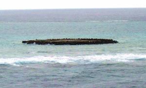
8 Japanese Effort on Okinotorishima Islandisation 1. 5 atoll reefs originally called Parece Vela by a Spanish sailor in Later called Douglas Reef after a British navigator William Douglas in No official mention about the Okinotorishima prior to 1888 by Japan. 4. In 1922 and 1925, Japan investigated the area and confirmed in 1931 that no other countries had claims and thus declared the reefs its territory. Kyushu-Palau Ridge Shima means island in Japanese
 Location of latitude: 20 degree 25 north Okinotorishima: longitude: 136 degree 04")
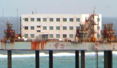
9 Kitakojima ( Northern Islet ) Minamikojima ( Southern Islet ) Higashikojima ( Eastern Islet ) Location of latitude: 20 degree 25 north Okinotorishima: longitude: 136 degree 04 east


10 Japanese Effort on Okinotorishima Islandisation Not much attention were given to those islets before 1970s: The construction of a naval base in 1939 was interrupted by the WWII. Later, the base has been referred to as a lighthouse and a meteorological observation site. On July 1, 1977, Japan extended its fishery jurisdiction up to 200 nm by enforcing the Law on Provisional Measures Relating to Fishing Zone.


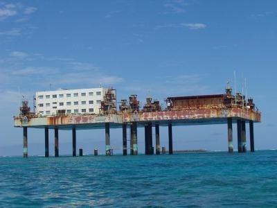
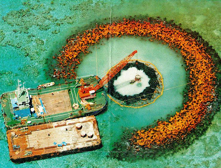
11 Okinotorishima Islandisation In 1980s, the sea level rise theory was employed and evidenced, and a proposal was raised to build constructions to keep the rocks above water. In 1987, the Japanese government launched an embankment building project.
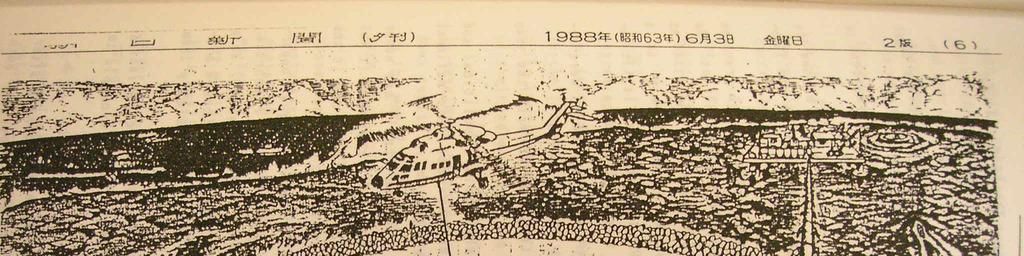
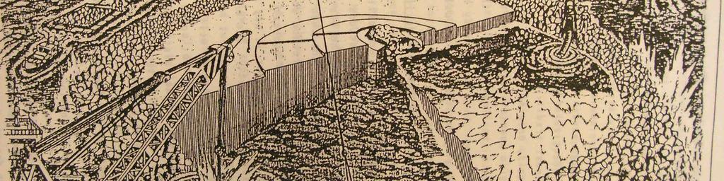
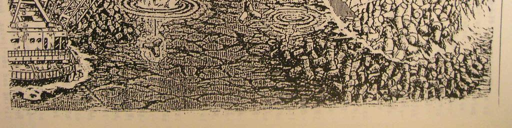
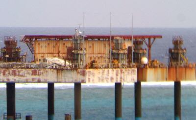
12 The construction started in 1988

 ) of 50 meters in")
 ) have been")
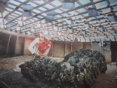
13 Japanese Effort on Okinotorishima Islandisation During , artificial structures (steel breakwaters and concrete walls) ) of 50 meters in diameter were built, and the original islets (natural rocks) ) have been completely covered up to stop the erosion.
14

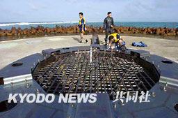
15 Japanese Effort on Okinotorishima Islandisation Station: 8 m Supporting structure: 13 m

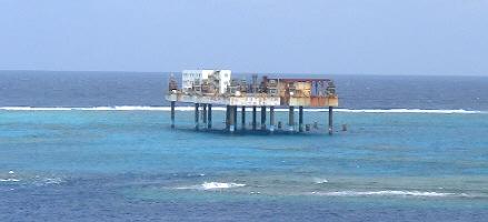
16 Japanese Effort on Okinotorishima Islandisation In 1999, the central government took over the administration and protection tasks according to its amended Coast Act. In 2004, the Nippon Foundation dispatched a mission to investigate how to make Okinotorishima and the surrounding EEZ utilized: to breed coral reef, build lighthouse, social infrastructure (port and houses) for human habitation, marine studies, and development, to promote sightseeing, and to build an ocean-thermal energy conservation power plant. In 2005, the Nippon Foundation dispatched another mission to focus on feasibility studies in the most promising fields of marine engineering, power generation etc. Hmm..I think there might be something naturally formed around there. Ah, here it is:okinotorishima island?

17 Japanese Effort on Okinotorishima Islandisation

18 Japanese Effort on Okinotorishima Islandisation


19 Tokyo Governor Shintaro Ishihara The 8-billion-Yen cover meter
, repaired a heliport, and placed an official address plaque.")
20 Japanese Effort on Okinotorishima Islandisation 2004, the OPRF organized the first conference in protecting the rocks, and later on set up regular forums to examine related issues. In 2005, the central government installed a Radar system ( 330 million), repaired a heliport, and placed an official address plaque. In 2007, the Japan Coast Guard installed a light beacon for surveillance. Japan has spent over $600 million fortifying the rocks to prevent them from being washed away and to meet the minimum criteria for being regarded as a legal island!

21 EEZ and CS based on Oknotorishima Rocks Without the Oknotorishi ma rocks, the TS of Japan will retreat to its south most tip of Minami-Io To-shima shima, and suffer a loss of 1550 sq km TS and 430,000 sq km EEZ.

22 Proposed Map of ECS Submission in 2005 ECS extension up to 350 nms
23 ECS Generated from Oknotorishima Rocks 1. Southern Kyushu-Palau Ridge Region, KPR 2. Minami-Io To Island Region,MIT 3. Minami-Tori Shima,MTS 4. Mogi Seamount Region,MGS 5. Ogasawara Plateau Region,OGP 6. Southern Oki-Daito Ridge Region,ODR 7. Shikoku Basin Region,SKB Japan ECS submission on 12 Nov. 2008

24 ECS Generated from Oknotorishima Rocks Japan Mogi Seamount Region The ECS is 740,000 sq km, about 2 times of its land territory (378,000). Shikoku Basin Region Minami-Tori Shima Ogasawara Island Region Plateau Region Minami-Tori Shima Island Southern Oki-Daito Ridge Region Okino-Tori Shima Island Southern Kyushu- Palau Ridge Region Palau Minami-Io To Island Region Northern Mariana Islands (US) Legend 200M from Japan s baseline Equidistance line from Japan s and other State s baseline 200M from other State s baseline Japan s proposed extended continental shelf ECS extension up to 550 nms!!!

25 Para. 2 of Section 6.1 of the Executive Summary of the Japanese Submission: it is suggested that the ridge forms part of the natural prolongation of Japan's land mass represented by Okinotorishima Island (so called!).
26 Concluding Remarks Maritime features could be accorded to maritime zones, but not all features are entitled to EEZ and beyond. The vagueness of UNCLOS island regime has resulted in: -- Enduring complexities of maritime claims -- Excessive baseline claims -- Sovereignty disputes over Islands -- Disputes over weight accorded to insular features Increasing assertiveness on maritime disputes Aggressive extended continental shelf submissions
27 Concluding Remarks Should interpretation and implementation of international laws be guided by general obligation of a State with good faith? As States move forward with excessive claims and islandsation initiatives, is there a potential danger of undermining international laws and encroachment of the common heritage of mankind? Who should defend the interests of international community, and how? 27
28 THANK YOU FOR YOUR ATTENTION! Guifang (Julia) Xue Law of the Sea Institute Ocean University of China 238 Songling Road, Qingdao , PR China Tel: Fax:
Some Thoughts on Maritime Delimitation among the Northeast Asian States
 Some Thoughts on Maritime Delimitation among the Northeast Asian States Seokwoo LEE Assistant Professor College of Law INHA University Korea leeseokwoo@inha.ac.kr 1 I. Common geographical features II.
Clive Schofield * and David Freestone **
 Holding Back the Waves: Options to Secure Maritime Jurisdictional Claims in the Face of Sea Level Rise Clive Schofield * and David Freestone ** *Australian National Centre for Ocean Resources and Security
Sam Bateman and. State Practice Regarding Straight Baselines In East Asia Legal, Technical and Political Issues in a
 State Practice Regarding Straight Baselines In East Asia Legal, Technical and Political Issues in a Changing Environment Sam Bateman and Clive Schofield The Australian National Centre for Ocean Resources
xxv PART I THE DIVIDED OCEANS: INTERNATIONAL LAW GOVERNING JURISDICTIONAL ZONES 1
 Contents Preface page xv List of Figures xvii List of Tables xviii List of Abbreviations xix Table of Cases xxi Table of Treaties and Instruments xxv PART I THE DIVIDED OCEANS: INTERNATIONAL LAW GOVERNING
Ocean Governance and the Japanese Basic Act on Ocean Policy
 Ocean Governance and the Japanese Basic Act on Ocean Policy Hiroshi Terashima Executive Director Ocean Policy Research Foundation 14 April 2009 The United Nations Nippon Foundation Fellowship Programme
Law of the Sea Symposium, February, 2016, TOKYO International Law for the Resources of the Sea
 Law of the Sea Symposium, 16-17 February, 2016, TOKYO International Law for the Resources of the Sea Segment 2 Governance of Resources of the Continental Shelf (including extended continental shelf) Introduction
Captain J. Ashley Roach, JAGC, USN (retired) Office of the Legal Adviser U.S. Department of State (retired) Visiting Senior Principal Research Fellow
 Office of the Legal Adviser U.S. Department of State (retired) Visiting Senior Principal Research Fellow") Captain J. Ashley Roach, JAGC, USN (retired) Office of the Legal Adviser U.S. Department of State (retired) Visiting Senior Principal Research Fellow Centre for International Law NUS Singapore SCS Award
Captain J. Ashley Roach, JAGC, USN (retired) Office of the Legal Adviser U.S. Department of State (retired) Visiting Senior Principal Research Fellow Centre for International Law NUS Singapore SCS Award
GeomaticsWorld. Issue No 3 : Volume 21. Helping to unravel Easter Island s mysterious statues. DGI 2013: maritime security highlighted
 GeomaticsWorld MARCH APRIL 2013 Issue No 3 : Volume 21 BIM: repeat the message even if you lose the will to live Helping to unravel Easter Island s mysterious statues DGI 2013: maritime security highlighted
The Relevance of Hydrography to UNCLOS; an Indonesian Perspective By: Prof. Dr. Hasjim Djalal, MA*
 The Relevance of Hydrography to UNCLOS; an Indonesian Perspective By: Prof. Dr. Hasjim Djalal, MA* As I understand it, the theme of this 6 th ABLOS Conference 2010 is Contentious Issues in UNCLOS- surely
Maritime delimitation and environmental protection of fragile seas
 Gemma Andreone Istituto di Studi Giuridici Internazionali - Consiglio Nazionale delle Ricerche Marsafenet Cost Action Chair - www.marsafenet.org Maritime delimitation and environmental protection of fragile
State Practice on the Establishment of Multiple Maritime Boundaries: Assessing the Challenges of Separating Seabed and Water Column Boundaries
 State Practice on the Establishment of Multiple Maritime Boundaries: Assessing the Challenges of Separating Seabed and Water Column Boundaries Professor Clive Schofield The Australian National Centre for
Underwater Parks: Three Case Studies, and a Primer on Marine Boundary Issues. Robert E. Johnson Leland F. Thormahlen
 Robert E. Johnson Leland F. Thormahlen Underwater Parks: Three Case Studies, and a Primer on Marine Boundary Issues Unlike boundaries on land, most marine boundaries are not marked with monuments or fences.
Sharing the Resources of the South China Sea
 Sharing the Resources of the South China Sea MARK J. VALENCIA Senior Fellow, East-West Center, Honolulu, Hawaii, U.SA. JON M. VAN DYKE Professor oflaw, Wm. S. Richardson School oflaw, University of Hawaii,
EXECUTIVE SUMMARY A PARTIAL SUBMISSION OF DATA AND INFORMATION ON THE OUTER LIMITS OF THE CONTINENTAL SHELF OF THE KINGDOM OF TONGA PURSUANT TO
 EXECUTIVE SUMMARY A PARTIAL SUBMISSION OF DATA AND INFORMATION ON THE OUTER LIMITS OF THE CONTINENTAL SHELF OF THE KINGDOM OF TONGA PURSUANT TO PART VI OF AND ANNEX II TO THE UNITED NATIONS CONVENTION
Indonesia s Internal Maritime Boundaries
 University of Wollongong-Lecture in Boundaries, November 2005 Indonesia s Internal Maritime Boundaries 1 Lecture Outline Indonesia's internal maritime boundaries Law no. 22/1999 --> Law no. 32/2004 Technical
Chapter 12: Pacific Realm and Polar Futures
 Geography: Realms, Regions and Concepts 15 th Edition By de Blij and Muller Chapter 12: Pacific Realm and Polar Futures Defining the Realm Sea Hemisphere: seas covering nearly an entire hemisphere Fragmented,
CONFERENCE OF PARLIAMENTARIANS OF THE ARCTIC REGION. UN LOS Convention and the extended continental shelf in the Arctic
 CONFERENCE OF PARLIAMENTARIANS OF THE ARCTIC REGION UN LOS Convention and the extended continental shelf in the Arctic Presentation given by Dr. Kamrul Hossain Finnish Parliament 18 November 2009 Contents
ITLOS s approach to the delimitation of the continental shelf beyond 200 M in Bangladesh/Myanmar: Theoretical and practical difficulties
 ITLOS s approach to the delimitation of the continental shelf beyond 200 M in Bangladesh/Myanmar: Theoretical and practical difficulties London International Boundary Conference 18-19 April 2013 Panel
REPUBLIC OF THE MARSHALL ISLANDS MARITIME ZONES DECLARATION ACT 2016.
 Republic of the Marshall Islands Maritime Zones Declaration Act 2016. 33MIRCCh.1Index TITLE 33 - MARINE ZONES AND PROTECTION OF MAMMALS CHAPTER 1 - MARITIME ZONE DECLARATION s Republic of the Marshall
World Oceans Day 2010 Our oceans: opportunities and challenges
 World Oceans Day 2010 Our oceans: opportunities and challenges Roundtable discussion on the United Nations Convention on the Law of the Sea fifteen years after its entry into force HOW EFFECTIVELY IS UNCLOS
Disputes Concerning the Delimitation of the Continental Shelf beyond 200 M
 Disputes Concerning the Delimitation of the Continental Shelf beyond 200 M Professor Clive Schofield Head of Research, WMU/Sasakawa Global Ocean Institute World Maritime University Sweden and Leonardo
Pacific Islands Regional Maritime Boundaries Project
 Pacific Islands Regional Maritime Boundaries Project 31 st Star Conference, Nadi, FIJI 6-8 June 2016 Jens Kruger Head of Ocean & Coastal Geoscience Sector Andrick Lal Project Officer (Surveying) Emily
Slide 1 Geography: Realms, Regions, and Concepts 15 th Edition. Slide 2. Slide 3 Defining the Realm. Chapter 12: Pacific Realm and Polar Futures
 Slide 1 Geography: Realms, Regions, and Concepts 15 th Edition Chapter 12: Pacific Realm and Polar Futures Slide 2 Slide 3 Defining the Realm Sea Hemisphere: seas cover nearly an entire hemisphere: Fragmented,
Briefing document of the status of maritime boundaries in Pacific island countries
 Secretariat of the Pacific Community Seventh Heads of Fisheries Meeting (28 Feb. 4 March 2011, Noumea, New Caledonia) Working Paper 5 Original: English Briefing document of the status of maritime boundaries
IMA s ROLE IN COASTAL AND OCEAN GOVERNANCE IN TRINIDAD AND TOBAGO
 IMA s ROLE IN COASTAL AND OCEAN GOVERNANCE IN TRINIDAD AND TOBAGO Presented by Rahanna Juman, Deputy Director (Ag.) About the Institute of Marine Affairs Institute of Marine Affairs (IMA) was established,
Polar complications in the law of the sea: A case study of the regime for research and survey activities in the Arctic Ocean
 2010 ABLOS Conference: Contentious Issues in UNCLOS Surely Not? International Hydrographic Bureau, 25-27 October 2010 Polar complications in the law of the sea: A case study of the regime for research
file:///c:/documents and Settings/kapilan/My Documents/WEB Domest...
 1 of 5 3/17/2011 1:15 PM Print Close Maritime Zones Law A LAW TO PROVIDE FOR THE DECLARATION OF THE TERRITORIAL SEA AND OTHER MARITIME ZONES OF SRI LANKA, AND ALL OTHER MATTERS CONNECTED THEREWITH OR INCIDENTAL
UNCLOS Article 76- Formulae and constraint lines
 UNCLOS Article 76- Formulae and constraint lines Dr Lindsay Parson (UNCLOS Group, National Oceanography Centre, UK) ABLOS TUTORIAL SESSION - Article 76 of UNCLOS 10th October 2005 IHO/IAG/IOC Advisory
Pacific Islands Regional Maritime Boundaries Project the latest Update. Malakai Vakautawale (Mr) Maritime Boundaries Adviser
 Maritime Boundaries Adviser") Pacific Islands Regional Maritime Boundaries Project the latest Update Malakai Vakautawale (Mr) Maritime Boundaries Adviser Consortium Partners 2 What we do? Provide technical advice and support on MB
Pacific Islands Regional Maritime Boundaries Project the latest Update Malakai Vakautawale (Mr) Maritime Boundaries Adviser Consortium Partners 2 What we do? Provide technical advice and support on MB
Draft Presentation Carleton Conference on the Arctic Is There a Need for New Legal Regime in the Arctic?
 Draft Presentation Carleton Conference on the Arctic Is There a Need for New Legal Regime in the Arctic? Donald McRae, University of Ottawa The climatic changes affecting the Arctic have lead to visions
MAPS AND COORDINATES...
 Table of Contents 1 INTRODUCTION... 2 2 MAPS AND COORDINATES... 3 3 ADVISORY ASSISTANCE FROM COMMISSION MEMBERS... 3 4 PROVISIONS OF ARTICLE 76 INVOKED... 3 5 OUTSTANDING MARITIME DELIMITATIONS... 4 6
NOAA Nautical Charts and Coastal and Marine Spatial Planning. Meredith Westington Chief Geographer NOAA/NOS/Office of Coast Survey
 NOAA Nautical Charts and Coastal and Marine Spatial Planning Meredith Westington Chief Geographer NOAA/NOS/Office of Coast Survey Ocean Policy Task Force What is CMSP? A comprehensive, adaptive, integrated,
E/CONF.105/115/CRP.115***
 E/CONF.105/115/CRP.115*** 30 June 2017 Original: English 11 th United Nations Conference on the Standardization of Geographical Names New York, 8-17 August 2017 Item 9a) of the provisional agenda* National
How to Deal with Maritime Boundary Uncertainty in Oil and Gas Exploration and Production Areas*
 The University of Texas School of Law Presented: International Upstream Energy Transactions January 17-18, 2013 Houston, TX How to Deal with Maritime Boundary Uncertainty in Oil and Gas Exploration and
Stewardship of the Central Arctic Ocean: The Arctic 5 versus the international community
 Stewardship of the Central Arctic Ocean: The Arctic 5 versus the international community The Central Arctic Ocean Ilulissat Declaration 2008 By virtue of their sovereignty, sovereign rights and jurisdiction
SIXTH REGULAR SESSION, 2017 C.B. NO A BILL FOR AN ACT
 NINETEENTH CONGRESS OF THE FEDERATED STATES OF MICRONESIA SIXTH REGULAR SESSION, 0 C.B. NO. - A BILL FOR AN ACT To amend title of the code of the Federated States of Micronesia by amending existing sections
The legal status of Dokdo under article 121 of the 1982 UNCLOS : is Dokdo entitled to generate EEZ or continental shelf?
 World Maritime University The Maritime Commons: Digital Repository of the World Maritime University World Maritime University Dissertations Dissertations 2009 The legal status of Dokdo under article 121
International Law in the South China Sea
 International Law in the South China Sea The Philippines-China Dispute Luz Danielle O. Bolong Harvard Law School April 2, 2014 Award on Jurisdiction, Figure 1 (citing RP Memorial, Figure 2.1; amti.csis.org
EXECUTIVE SUMMARY A SUBMISSION OF DATA AND INFORMATION ON THE OUTER LIMITS OF THE CONTINENTAL SHELF OF THE REPUBLIC OF NIGERIA PURSUANT TO
 EXECUTIVE SUMMARY A SUBMISSION OF DATA AND INFORMATION ON THE OUTER LIMITS OF THE CONTINENTAL SHELF OF THE REPUBLIC OF NIGERIA PURSUANT TO PART VI OF AND ANNEX II TO THE UNITED NATIONS CONVENTION ON THE
Identification of Islands and Standardization of Their Names
 Identification of Islands and Standardization of Their Names Submitted by INDONESIA UNITED NATIONS GROUP OF EXPERTS ON GEOGRAPHICAL NAMES Eleventh United Nations Conference on the Standardization of Geographical
JOINT SUBMISSION TO THE COMMISSION ON THE LIMITS OF THE CONTINENTAL SHELF BY TUVALU, THE REPUBLIC OF FRANCE AND NEW ZEALAND (TOKELAU)
") JOINT SUBMISSION TO THE COMMISSION ON THE LIMITS OF THE CONTINENTAL SHELF BY TUVALU, THE REPUBLIC OF FRANCE AND NEW ZEALAND (TOKELAU) TABLE OF CONTENTS i. PREFACE... iii ii. LIST OF FIGURES... iv iii.
JOINT SUBMISSION TO THE COMMISSION ON THE LIMITS OF THE CONTINENTAL SHELF BY TUVALU, THE REPUBLIC OF FRANCE AND NEW ZEALAND (TOKELAU) TABLE OF CONTENTS i. PREFACE... iii ii. LIST OF FIGURES... iv iii.
MARITIME PLANNING IN PORTUGAL
 MARITIME PLANNING IN PORTUGAL Marta Chantal Ribeiro 2 May 2007 In Portugal there is currently no strategic planning system in force for the maritime area as a whole The maritime area under Portuguese jurisdiction
Situational Report HOW PLANET MONITORS DEVELOPMENTS IN THE SOUTH CHINA SEA AUGUST 1, 2016 IMAGE ACQUIRED: JULY 22, 2015 PLANET.
 Situational Report IMAGE ACQUIRED: JULY 22, 2015 HOW PLANET MONITORS DEVELOPMENTS IN THE SOUTH CHINA SEA AUGUST 1, 2016 PRESS@PLANET.COM PLANET.COM THE SITUATION An international tribunal in The Hague
OUTER CONTINENTAL SHELF CLAIMS IN THE ARCTIC. Presentation given by Dr. Kamrul Hossain ASA University Bangladesh 15 March 2010
 OUTER CONTINENTAL SHELF CLAIMS IN THE ARCTIC Presentation given by Dr. Kamrul Hossain ASA University Bangladesh 15 March 2010 Contents Historical background of the continental shelf Concept of continental
Maritime Boundary Delimitation: Recent ICJ Jurisprudence Nicaragua v Colombia; Peru v Chile
 Maritime Boundary Delimitation: Recent ICJ Jurisprudence Nicaragua v Colombia; Peru v Chile May 28, 2014 Prof. Seokwoo LEE Inha University Law School leeseokwoo@inha.ac.kr 1 Recent Developments The Black
COMPLICATIONS IN DELIMITING THE OUTER CONTINENTAL SHELF. Ron Macnab Geological Survey of Canada (Retired)
") COMPLICATIONS IN DELIMITING THE OUTER CONTINENTAL SHELF Ron Macnab Geological Survey of Canada (Retired) DISCLAIMER The contents of this presentation are the author s personal views only, and do not represent
COMPLICATIONS IN DELIMITING THE OUTER CONTINENTAL SHELF Ron Macnab Geological Survey of Canada (Retired) DISCLAIMER The contents of this presentation are the author s personal views only, and do not represent
The Place of Joint Development in the Sustainable Arctic Governance
 The Place of Joint Development in the Sustainable Arctic Governance ShipArc2015: Joint WMU - IMO - Arctic Council International Conference on Safe and Sustainable Shipping in a Changing Arctic Environment
Natura 2000 in the marine environment: state of implementation and next steps
 Life on the blue planet: biodiversity research and the new European marine policies EPBRS European Platform on Biodiversity Research Strategy Porto, Portugal 7-9 November 2007 Natura 2000 in the marine
Outer Continental Shelf
 The Delimitation of the Outer Continental Shelf Presentation by Stephen Fietta Monaco, 17 October 2008 Latham & Watkins is the business name of Latham & Watkins (London) LLP, a registered limited liability
Maritime Boundary Negotiations National Considerations Dr. Robert W. Smith
 Maritime Boundary Negotiations National Considerations Dr. Robert W. Smith ABLOS: ADDRESSING DIFFICULT ISSUES IN UNCLOS 28 OCTOBER 2003 Practical Steps in the Negotiating Process 1. The Delimitation Process
Mindful of the interests which the Parties share as immediate neighbours, and in a spirit of cooperation, friendship and goodwill; and
 page 1 Delimitation Treaties Infobase accessed on 13/03/2002 Treaty between the Government of Australia and the Government of the Republic of Indonesia establishing an exclusive economic zone boundary
Delimitation of the continental shelf beyond 200 M in the light of recent case law
 Delimitation of the continental shelf beyond 200 M in the light of recent case law K.G. Jebsen Centre for the Law of the Sea Centre Days Workshop 23 September 2014 Session 2 Alex G. Oude Elferink K.G.
A National Geocentric Datum and the Administration of Marine Spaces in Malaysia 2
 A National Geocentric Datum and the Administration of Marine Spaces in Malaysia 2 CheeHai TEO 3 and Ahmad FAUZI 4 Abstract Malaysia is a country with two primary land masses, Peninsular Malaysia and East
MARITIME ZONES FROM ISLANDS AND ROCKS. Paper by Professor Clive R. Symmons for the CIL Roundtable Singapore June 2013
 MARITIME ZONES FROM ISLANDS AND ROCKS Paper by Professor Clive R. Symmons for the CIL Roundtable Singapore June 2013 Basic Definition and Zone-Creating Capacity of an Island in IL . See Art 121(2) UNCLOS:
DELIMITATION OF THE MOZAMBIQUE MARITIME BOUNDARIES WITH NEIGHBORING STATES (INCLUDING THE EXTENDED CONTINENTAL SHELF) AND MANAGEMENT OF OCEAN ISSUES
 AND MANAGEMENT OF OCEAN ISSUES") DELIMITATION OF THE MOZAMBIQUE MARITIME BOUNDARIES WITH NEIGHBORING STATES (INCLUDING THE EXTENDED CONTINENTAL SHELF) AND MANAGEMENT OF OCEAN ISSUES Elisio B. Jamine United Nations The Nippon Fellowship
DELIMITATION OF THE MOZAMBIQUE MARITIME BOUNDARIES WITH NEIGHBORING STATES (INCLUDING THE EXTENDED CONTINENTAL SHELF) AND MANAGEMENT OF OCEAN ISSUES Elisio B. Jamine United Nations The Nippon Fellowship
Marine/Maritime Spatial Planning Andrej Abramić
 Marine/Maritime Spatial Planning Andrej Abramić EcoAqua SUMMER SCHOOL: Ecosystem approach to aquaculture 26-29th of October 2015 Research and Technology to enhance excellence in Aquaculture development
Iceland and the Arctic: The Politics of Territoriality. Valur Ingimundaron Professor of Contemporary History, University of Iceland
 Iceland and the Arctic: The Politics of Territoriality Valur Ingimundaron Professor of Contemporary History, University of Iceland Drivers of Icelandic Arctic Policies Geostrategic Position Economic Interests
ARTICLE I NATIONAL TERRITORY
 ARTICLE I NATIONAL TERRITORY The national territory comprises the Philippine archipelago, with all the islands and waters embraced therein, and all other territories over which the Philippines has sovereignty
Geopolitical Considerations of the Senkaku Islands
 Geopolitical Considerations of the Senkaku Islands Akiyama Masahiro 1. Introduction 2. Geographic Conditions 3. Legal Effects of Islands as Territory 4. Maritime Interests and Security Matters 5. Geopolitical
MARINE SPATIAL PLANNING & MARINE CADASTRE: CHALLENGES AND ISSUES
 MARINE SPATIAL PLANNING & MARINE CADASTRE: CHALLENGES AND ISSUES Roger Longhorn Secretary General, GSDI Association rlonghorn@gsdi.org Member, IHO Marine SDI Working Group ral@alum.mit.edu Member, UNESCO
Marine Spatial Planning in Hellas; Recent Facts and Perspectives
 XXV FIG CONGRESS Engaging the Challenges, Enhancing the Relevance Kuala Lumpur, Malaysia 16 21 June 2014 Marine Spatial Planning in Hellas; Recent Facts and Perspectives Mrs. Chaiditsa BOLANOU Surveying
CONTINENTAL SHELF SUBMISSION OF ANGOLA - EXECUTIVE SUMMARY -
 CONTINENTAL SHELF SUBMISSION OF ANGOLA - EXECUTIVE SUMMARY - INDEX List of Figures 2 List of Tables 3 1 Introduction 5 2 Provisions of Article 76 7 3 Angolan Institutions responsible for the Submission
Offshore Energy and Maritime Spatial Planning in the German EEZ
 Offshore Energy and Maritime Spatial Planning in the German EEZ Bettina Käppeler, BSH Federal Maritime and Hydrographic Agency On Duty for Shipping and Seas German Exclusive Economic Zone EEZ not part
Country Fiche Latvia Updated October 2016
 Country Fiche Latvia Updated October 2016 1. General information Marine area under Latvian jurisdiction includes inland sea waters, Territorial sea (12 nautical miles from the baseline) and exclusive economic
A scientific challenge to the delineation of Japan s continental shelf
 Research paper A scientific challenge to the delineation of Japan s continental shelf - Contribution to validating the Japan s rights over marine areas based on earth science- Akira Nishimura * 1, Makoto
Tore Henriksen a & Geir Ulfstein b a Faculty of Law, University of Tromsø, Tromsø, Norway. Available online: 18 Feb 2011
 This article was downloaded by: [Bibliotheek van het Vredespaleis] On: 03 May 2012, At: 03:44 Publisher: Taylor & Francis Informa Ltd Registered in England and Wales Registered Number: 1072954 Registered
The Law of the Sea Convention and Sea Level Rise in the light of the South China Sea Arbitration
 University of Wollongong Research Online Faculty of Law, Humanities and the Arts - Papers Faculty of Law, Humanities and the Arts 2017 The Law of the Sea Convention and Sea Level Rise in the light of the
Linking Global and Regional Levels in the Management of Marine Areas Beyond National Jurisdiction
 Linking Global and Regional Levels in the Management of Marine Areas Beyond National Jurisdiction South Atlantic Region Session 4: «Experiences, Priorities and Opportunities in the South Atlantic and Indian
A Parliamentary Resolution on Iceland's Arctic Policy
 A Parliamentary Resolution on Iceland's Arctic Policy (Approved by Althingi at the 139th legislative session March 28 2011) Althingi resolves to entrust the Government, after consultations with Althingi,
Guifang (Julia) XUE *
 XUE *") How MuchCanaRockGet? How MuchCanaRockGet? A ReflectionfromtheOkinotorishimaRocks Guifang (Julia) XUE * Abstract:ThepaperexaminestheOkinotorishimaRocksandtheirentitle- mentingeneratingextendedjurisdictionalzones,togetherwithissuesaggrava-
How MuchCanaRockGet? How MuchCanaRockGet? A ReflectionfromtheOkinotorishimaRocks Guifang (Julia) XUE * Abstract:ThepaperexaminestheOkinotorishimaRocksandtheirentitle- mentingeneratingextendedjurisdictionalzones,togetherwithissuesaggrava-
Dorset Coastal Explorer Planning
 Dorset Coastal Explorer Planning Please read this information carefully. If you wish to proceed after reading this information you must signify your agreement to the following conditions of access by selecting
Capacity Development and ABNJ
 ABNJ Regional Leaders Program First Session Capacity Development and ABNJ Regional and National Perspectives Examples from Africa January 21, 2015 Conference Room 7, United Nations HQ New York, USA Outline
ECONOMIC AND SOCIAL COUNCIL 10 July 2007
 UNITED NATIONS E/CONF.98/CRP.22 ECONOMIC AND SOCIAL COUNCIL 10 July 2007 Ninth United Nations Conference on the Standardization of Geographical Names New York, 21-30 August 2007 Item 9(a) of the provisional
Pacific Islands Regional Maritime Boundaries Project
 Pacific Islands Regional Maritime Boundaries Project Presented By Filimoni Yaya (Andrick Lal, Sachindra Singh, Emily Artack) Geoscience Division Pacific Community (SPC Geoscience Division, GSD STAR Sessions,
Dorset MSP Evidence Base 18 th February Ness Smith C-SCOPE Project Officer
 Dorset MSP Evidence Base 18 th February 2011 Ness Smith C-SCOPE Project Officer Sectoral Topic Papers MMA Description document gives an overview of the area, it s physical and human influences 20 Topic
EFFECTIVE TROPICAL CYCLONE WARNING IN BANGLADESH
 Country Report of Bangladesh On EFFECTIVE TROPICAL CYCLONE WARNING IN BANGLADESH Presented At JMA/WMO WORKSHOP ON EFFECTIVE TROPICAL CYCLONE WARNING IN SOUTHEAST ASIA Tokyo, Japan,11-14 March 2014 By Sayeed
NAVIGATION AND VESSEL INSPECTION CIRCULAR NO
 COMDTPUB P16700.4 NVIC 13-92 15 Dec 1992 NAVIGATION AND VESSEL INSPECTION CIRCULAR NO. 13-92 Electronic Version for Distribution Via the World Wide Web Subj: Captain of the Port Zone Boundaries 1. PURPOSE.
Article 76, variations in annotation and implementation seen in submission documents for the claim of Extended Continental Shelf
 Article 76, variations in annotation and implementation seen in submission documents for the claim of Extended Continental Shelf Mr. Shin Tani Chairman, IHO/IAG Advisory Board on the Law of the Sea (ABLOS)
CONTENTS. PREFACE AND ACKNOWLEDGEMENTS...xi ABBREVIATIONS... xiii FIGURES...xvii INTRODUCTION...1
 CONTENTS PREFACE AND ACKNOWLEDGEMENTS...xi ABBREVIATIONS... xiii FIGURES...xvii INTRODUCTION...1 CHAPTER 1 MAPS OF THE MARITIME WORLD AND LEGAL DEFINITIONS...21 1.1 Maps of the Maritime World...21 1.1.1
Small area of the ocean that is partially surrounded by land. The Ocean Basins. Three Major Oceans. Three Major Oceans. What is a SEA?
 The Ocean Basins How Deep is the Ocean? 1 2 Three Major Oceans Three Major Oceans Pacific Atlantic the shallowest ocean (3.3km average depth) Indian second shallowest ocean (3.8km average depth) Pacific
Croatian physical planning system and strategic approach to MSP
 W 1/7 Past two years all over the Europe: case studies 2 Croatian physical planning system and strategic approach to MSP Vesna Marohnić Kuzmanović Head of Department Croatian Institute for Spatial Development
SOLVING THE RIDGES ENIGMA OF ARTICLE 76 OF THE UNITED NATIONS CONVENTION ON THE LAW OF THE SEA. Written by: George Taft Presented by: George Taft
 SOLVING THE RIDGES ENIGMA OF ARTICLE 76 OF THE UNITED NATIONS CONVENTION ON THE LAW OF THE SEA Written by: George Taft Presented by: George Taft (The views contained herein are those of the author and
CLT/HER/CHP/OG 1- page 29
 CLT/HER/CHP/OG 1- page 29 MODEL INVENTORY SHEET FOR UNDERWATER CULTURAL HERITAGE COUNTRY REGION, PROVINCE COMPETENT AUTHORITY REGISTERED BY (name, position) Date Email / Tel nº SITE NAME (provide also
Legal Interpretation of Submarine Ridges & Submarine Elevations
 Legal Interpretation of Ridges & Article 76, paragraph 6 New Knowledge and Changing Circumstances in the Law of the Sea Reykjavik, Iceland June 28, 2018 Kevin Baumert U.S. Department of State U.S. ECS
Australia Government Geospatial Capacity Building Efforts in Asia and the Pacific. Dr John Dawson
 Australia Government Geospatial Capacity Building Efforts in Asia and the Pacific Dr John Dawson Presentation Overview About Geoscience Australia Examples of Geospatial Capacity Building Activity Geodesy
MODELS AND TOOLS FOR GOVERNANCE OF
 Working Papers Collection No. 1/2015 MODELS AND TOOLS FOR GOVERNANCE OF THE ADRIATIC AND IONIAN SEAS www.unimc.it/maremap NATIONAL POLITICS AND EU POLITICS: THE MARITIME SPATIAL PLANNING AND INTEGRATED
National Perspectives - Portugal. Margarida Almodovar
 National Perspectives - Portugal Margarida Almodovar margarida.almodovar@mam.gov.pt from base line to the external limit of the continental shelf behind 200 miles and according to UNCLOS definitions Economic
UNDERSEA FEATURE NAME PROPOSAL (See IHO-IOC Publication B-6 and NOTE overleaf)
") INTERNATIONAL HYDROGRAPHIC ORGANIZATION INTERGOVERNMENTAL OCEANOGRAPHIC COMMISSION (of UNESCO) Note: The boxes will expand as you fill the form. UNDERSEA FEATURE NAME PROPOSAL (See IHO-IOC Publication
INTERNATIONAL HYDROGRAPHIC ORGANIZATION INTERGOVERNMENTAL OCEANOGRAPHIC COMMISSION (of UNESCO) Note: The boxes will expand as you fill the form. UNDERSEA FEATURE NAME PROPOSAL (See IHO-IOC Publication
Cross-border Maritime Spatial Plan for the Black sea - Romania and Bulgaria project
 Cross-border Maritime Spatial Plan for the Black sea - Romania and Bulgaria project in Romania and Bulgaria Plan Presentation A first step in the management of the marine areas of Romania and Bulgaria
Marine Geospatial Software: Generating Economic Benefits from Hydrographic Data and Calculation of Maritime Boundaries
 Marine Geospatial Software: Generating Economic Benefits from Hydrographic Data and Calculation of Serge LEVESQUE and Alexis CARDENAS, Canada Key words: marine geospatial data, hydrography, economic benefits,
ALASKA DEEP-DRAFT ARCTIC PORT EVALUATION
 ALASKA DEEP-DRAFT ARCTIC PORT EVALUATION Joint Study of Federal and State June 20, 2012 Opportunity and Constraint Warming of Arctic region is leading to new maritime opportunities. Thawing of permafrost
Legal Implications for Delimitation of Airspace and Outer Space
 Legal Implications for Delimitation of Airspace and Outer Space Prof. Joanne Irene Gabrynowicz IISL/ECSL Symposium at the Legal Subcommittee of the Committee on the Peaceful Uses of Outer Space 28 March
Third Annual Climate Science and Policy Conference, UC Santa Cruz: Earth s Climate Future: Unchartered Territory
 Third Annual Climate Science and Policy Conference, UC Santa Cruz: Earth s Climate Future: Unchartered Territory Geopolitics of Climate Change: The Arctic Case Steven L. Lamy, PhD Vice Dean for Academic
Preliminary Information Indicative of the Outer Limits of the Continental Shelf Beyond 200 Nautical Miles of the People s Republic of China
 (Translation) Preliminary Information Indicative of the Outer Limits of the Continental Shelf Beyond 200 Nautical Miles of the People s Republic of China 1. The People s Republic of China ratified the
No. 2009/9 3 February Maritime Delimitation in the Black Sea (Romania v. Ukraine)
") INTERNATIONAL COURT OF JUSTICE Peace Palace, Carnegieplein 2, 2517 KJ The Hague, Netherlands Tel.: +31 (0)70 302 2323 Fax: +31 (0)70 364 9928 Website: www.icj-cij.org Press Release Unofficial No. 2009/9
INTERNATIONAL COURT OF JUSTICE Peace Palace, Carnegieplein 2, 2517 KJ The Hague, Netherlands Tel.: +31 (0)70 302 2323 Fax: +31 (0)70 364 9928 Website: www.icj-cij.org Press Release Unofficial No. 2009/9
SUMMARY OF THE 2011 TYPHOON SEASON
 ECONOMIC AND SOCIAL COMMISSION FOR ASIA AND THE PACIFIC AND WORLD METEOROLOGICAL ORGANIZATION WRD/TC.44/4.1 Add. 2 06 February 2012 Typhoon Committee Forty Fourth Session 06 to 12 February 2012 Hangzhou,
The Changing Arctic: Strategic Opportunities and Challenges
 The Changing Arctic: Strategic Opportunities and Challenges Sherri Goodman Senior Vice President & General Counsel Executive Director, CNA Military Advisory Board 1 New Access to Resources Oil and Gas
Geopolitics of the South China Sea
 Geopolitics of the South China Sea Ben Cahill Manager, Research and Advisory Group February 21, 2012 Powerful Thinking for the global energy industry Is the South China Sea The Future of Conflict? Just
This Book Belonged to
 THE AMERICAN UNIVERSITY Washington College of Law Library This Book Belonged to The Private Collection of Judge Richard R, Baxter I THE AMERICAN UNIVERSITY Washington College of Law Law Library W-, D.C.
Your web browser (Safari 7) is out of date. For more security, comfort and the best experience on this site: Update your browser Ignore
 is out of date. For more security, comfort and the best experience on this site: Update your browser Ignore") Your web browser (Safari 7) is out of date. For more security, comfort and the best experience on this site: Update your browser Ignore Activityengage O CEAN AND SEA BO RDERS Who has the rights to valuable
Your web browser (Safari 7) is out of date. For more security, comfort and the best experience on this site: Update your browser Ignore Activityengage O CEAN AND SEA BO RDERS Who has the rights to valuable