Working Together and Building a Secure and Prosperous Society
|
|
|
- Bernadette Smith
- 6 years ago
- Views:
Transcription
1 APRSAF-13 Working Together and Building a Secure and Prosperous Society Space-Related Activities in Thailand 5 December 2006
2 1. Earth Observation 2. Space Communications 2.1 Thai Communication Satellites: ipstar Broadband Satellite System 2.2 Application in Tele-education: education: Distance Learning Foundation (DLF) 3. Satellite Technology Development - Thai Micro-SATellite (TMSAT) - Thai Earth Observation Satellite (THEOS) 4. Human Resources Development 5. Cooperation Network of Space Activities
3 1. Earth Observation (EO) Ground receiving station for remote sensing satellite such as LANDSAT, SPOT, RADARSAT, NOAA. Capable of image data reception, processing, and distribution for both national and international users. Data obtained can be applied in various fields; namely agriculture, forestry, geology, water resource, land use, oceanography and fisheries, archeology, environment, disaster monitoring and assessment. Data are archived for more than 20 years.
4 Data reception at Lad Krabang: LANDSAT, SPOT, RADARSAT, NOAA. RADARSAT LANDSAT-7 IKONOS SPOT-2, 4, 5


5 Satellite Data Archives: IRS, JERS-1, MOS, LANDSAT 2, 3, 4, 5, 7, ERS LANDSAT-7 MOS IRS JERS-1 LANDSAT 5


6 The ground station accommodates image data reception, processing, and distribution for both national and international users. Area coverage Data processing 9 m. Antenna Ground Receiving Station, Lad Krabang


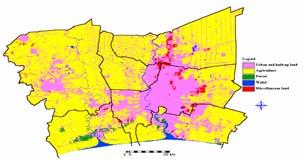


7 Applications of EO data in agriculture, forestry, geology, land use, water resource, oceanography and fisheries, archeology, environment, disaster monitoring and assessment. นนทบ ร ปท มธาน นครปฐม กร งเทพมหานคร สม ทรสาคร สม ทรปราการ

8 Space-Related Activities in Thailand Example of EO data in Land Use.


9 Example of EO data in Fisheries.


10 Example of EO data in Disaster Monitoring and Assessment.
.")
11 2. Space Communications 2.1 Thai Communication Satellites: Thaicom - Thailand has several communication satellites in Geo-Stationary orbit over Asia. They are Thaicom-1, launched in 1993, Thaicom-2, launched in 1994, Thaicom-3, launched in 1997, and Thaicom-5 recently launched in May 2006 (coverage Asia, Europe, Australia and Africa). - These satellites have been utilized in providing services such as television broadcasting, internet via satellite, and transponder leasing.
12 ipstar (ipstar Broadband Satellite System) - Broadband Internet bandwidth - Large area of coverage (throughout Asia), and fast and flexible service deployment


13 Commercial services include: Transponder Leasing Service Teleport and Digital DTH Service Global Digital TV Service Business and Educational TV Satellite Internet Rural Telephony Emergency communication in the events of an earthquake, flood, landslide or other natural disaster.
 Background Initiated in 1996 A realization of His Majesty the King Bhumibol Adulyadej s advocacy for life-long long")
14 2. Space Communications 2.2 Application in Tele-education: education: Distance Learning Foundation (DLF) Background Initiated in 1996 A realization of His Majesty the King Bhumibol Adulyadej s advocacy for life-long long learning and providing opportunity for remote parts of the country to access to knowledge/education/news. A public-private private partnership module: corporation of stakeholders includes government agencies (Ministry of Education, Ministry of Information, communications and Technology, Ministry of Foreign Affairs, Royal Thai Army) and semi-government agencies (Telephone Organization of Thailand, Communications Authority of Thailand) and private companies (Shin Corporation and UBC). Programme reached 3,000 secondary schools and 7,000 primary schools (327 Moslem schools in Southern provinces).


15 elearning of DLFeSchool: Wang Klaikangwon serves as parent school Linked by two fibres optic to Thaicom Teleport and DTH Centre for satellite uplink Participating schools are equipped with videoconferencing devices (ADSL, ipstar)

16 Recognitions: Visits to DLF by foreign dignitaries and media DLF and OU as model for Public-Private Private partnership Low-cost distance learning management Human knowledge development in the region Royal gift to neighboring countries: Cambodia, Laos, Myanmar and Vietnam


17 Societal Benefits: Providing access to education in remote areas and strengthening the foundation of knowledge without limits in boundaries.
18 3. Satellite Technology Development - Thai Micro-SATellite (TMSAT) - Thai Earth Observation Satellite (THEOS) Thai Micro-SATellite (TMSAT) - A joint venture between Mahanakorn University of Technology (MUT) and United Communication Company (UCOM) collaborating with the Centre for Satellite Engineering Research at the University of Surrey S (UK) - TMSAT 1 was launched in July In Oct 1998 the name changed to THAI-PAHT - THAI-PAHT 2 project started in 2002 by a group of lecturers and graduate students - THAI-PAHT 2 has capability for research on Wideband CDMA mobile communication
19 Thai Earth Observation Satellite (THEOS) Thailand-France cooperation Scheduled to launch in mid-2007 Fully owned and operated by GISTDA with EADS Astrium as prime contractor Facilities for data processing in Thailand THEOS to provide imagery in visible and near infrared region of the electromagnetic spectrum, similar to first three bands of SPOT family Life expectancy of five years.


20 THEOS Design and Construction


21 4. Human Resources Development The degree programme (Bachelor, Master, Doctoral) and International courses on space technology and applications have been carried out in universities/academic institutes. The training activities are conducted by Institute of Space Knowledge Development of GISTDA and 5 regional partner-centers. The curriculum and number of courses are increasing. Naraesuan center Chiangmai center

22 Human Resources Development Annual training courses offered by GISTDA: Applications of GIS to Spatial Data Analysis and Management Fundamentals of Remote Sensing Applications of GPS to Spatial Data Management Advanced Techniques of 3D Analysis Environmental Modeling Techniques using GIS Applications of Geo-informatics to Natural Resources and Environmental Management Advanced Remote Sensing Orthophoto Processing from High Resolution Image Internet GIS Technology and Web MapServer Programming for GIS THEOS Image Processing and Its Applications

 Technical trainings of ALOS pilot project")
23 Human Resources Development Thai-French Training On-the-job training at Astrium, Toulouse, France, March 2005 International training courses under joint research project: Scholastics trainings funded by the French government (Thailand-France) Technical trainings of ALOS pilot project (Thailand-Japan) Etc..

24 5. Cooperation Network of Space Activities - Cooperation with various countries - Cooperation with international organizations
25 Cooperation with various countries
26 Country Japan India CLMV China Korea Malaysia Organization JAXA (Japan Aerospace Exploration Agency ) India Space Research Organization Laos Vietnam: Remote Sensing Centre Cambodia CAS (China Academy of Science) NRSCC (National Remote Sensing Centre of China) Satrec Initiative Ltd. MACRES (Malaysian Centre for Remote Sensing) MOU: ALOS Data sub-node and arrangement on ALOS Pilot Project MOU on MODIS (AIT / Tokyo U) Agreement G-G G G on Cooperation in Exploration and Use of Outer Space for Peaceful Purposes: 5 yrs : Two Joint WG Meetings in India Laos, Vietnam, Cambodia: Training Vietnam: MOU with RSC, Vietnam, focusing on data services, personnel exchange, joint research project, technical workshop Workshop on Remote Sensing and GIS ASEAN+3 Satellite Data Archive for Environmental Study (KARI) Human Resource Development (Satrec( Initiatives) Training Joint WG Meeting Joint Research Activities France Russia CNES (Centre National D D Etudes Spatiales) Russian government NPO Mashinostroyenia Agreement G-G G G on Space Technologies and Applications: Human Resource Development (degree programme,, short term training, long term training, seminar) THEOS project Agreement G-G G G (under processed) Training on Radar Processing and Satellite Technology USA USGS MOU with US-Geological Survey on Earth Science Reception of Landsat Data Canada Natural Resource Canada (NR Can) MOU with NRCan Joint Seminar & Workshop Exchange of personnel Reception of Radarsat Data
 Regional cooperation APSCO Asian cooperation SCOSA APRSAF APAN ADPC FAO COSPAR Others AARS ISPRS etc.")
27 Cooperation with International Organizations UN-COPOUS (1committee, 2sub-committees) Global cooperation EOS/GEO CEOS UN-ESCAP CSSTEAP (RESAP-ICC-4WGS) Regional cooperation APSCO Asian cooperation SCOSA APRSAF APAN ADPC FAO COSPAR Others AARS ISPRS etc.
28 UN COPUOS EOS/GEO CEOS Organization Committee on the Peaceful Uses of Outer Space Earth Observation Summit/Group on Earth Observations Committee on Earth Observation Satellites Thailand s s status A country member in 67 countries. Active participation A country member in 65 countries and the European Commission. Executive committee. 25 Members (most of which are space agencies) and 20 Associates (national and international organizations). UN-ESCAP CSSTEAP APRSAF SCOSA Economic and Social Commission for Asia and the Pacific Centre for Space Science and Technology Education in Asia and the Pacific Asia-Pacific Regional Space Agency Forum Subcommittee on Space Technology and Applications - National focal point of RESAP. - National contact point of working group on RS/GIS/SbP SbP and MetSat, SatCom,, and SSTA. Governing Board member (represented by member states and UN agency: 13 Members) - Participation in forum -Member - Participation in meeting and other activities. Others: ADPC APAN FAO COSPAR AARS ISPRS Asian Disaster Preparedness Center Asia Pacific Advanced Network Food and Agriculture Organization Committee on Space Research Asian Association on Remote Sensing International Society on Photogrammetry and Remote Sensing


29 Seminar, conference, meeting activities.

30 A Way Towards Working Together and Building a Secure and Prosperous Society
RESAP Progress Report
 RESAP Progress Report December 2016 to October 2017 Presentation to the Twenty-first session of the Intergovernmental Consultative Committee on the Regional Space Applications Programme for Sustainable
Contribution to global Earth observation from satellites
 Contribution to global Earth observation from satellites - JAXA s Earth Observation strategy - April 16, 2008 Makoto Kajii Japan Aerospace Exploration Agency Earth Observation Summits and GEOSS 1 st EO
The International Charter Space and Major Disasters is further strengthening its contribution to disaster management worldwide.
 28 September 2012 Issue 3 The International Charter Space and Major Disasters is further strengthening its contribution to disaster management worldwide. Building on a decade of success in making satellite
Earth Observations as a Tool To Achieve Sustainable Development Goals
 The image part with relationship ID rid3 was not found in the file. 16/10/2017 Earth Observations as a Tool To Achieve Sustainable Development Goals LI Jing, China GEO On behalf of the Group on Earth Observations
Building Institutional Capacity for Multi-Hazard Early Warning in Asia and the Pacific Subtitle
 Building Institutional Capacity for Multi-Hazard Early Warning in Asia and the Pacific Subtitle Title Keran Wang Chief, Space Applications Section ICT and Disaster Risk Reduction Division 22 May 2018 Pillar
AND THE COOPERATION WITH SENTINEL ASIA FOR DISASTER MANAGEMENT
 Ministry of Natural resources and Environment National Remote Sensing DEpartment NATIONAL REMOTE SENSING DEPARTMENT (NRSD) AND THE COOPERATION WITH SENTINEL ASIA FOR DISASTER MANAGEMENT By: Dr. Chu Hai
Space Applications for Disaster Risk Reduction and Sustainable Development
 Space Applications for Disaster Risk Reduction and Sustainable Development Space Applications Section (SAS) ICT and Disaster Risk Reduction Division (IDD) UNESCAP Contents I. RESAP Activities 2016-2017
From PCGIAP to UN GGIM AP: A Regional Perspective on GGIM
 Regional Committee of United Nations Global Geospatial Information Management for Asia and the Pacific (UN-GGIM-AP) Established by a United Nations Resolution From PCGIAP to UN GGIM AP: A Regional Perspective
Indian Earth Observation Programme
 Indian Earth Observation Programme Dr. Jai Singh Parihar Dy. Director Remote Sensing Applications Area (RESA) Space Applications Centre (ISRO) Ahmedabad 380 015 India jsparihar@sac.isro.gov.in Presentation
SDG s and the role of Earth Observation
 SDG s and the role of Earth Observation Christian Heipke IPI - Institute for Photogrammetry and GeoInformation Leibniz Universität Hannover Germany Secretary General, ISPRS 1. No Poverty 2. Zero Hunger
Capacity Building in Applications of Remote Sensing and GIS for Disaster Management
 Capacity Building in Applications of Remote Sensing and GIS for Disaster Management M.K. Hazarika, L. Samarakoon, N. Senevirathne, J.S.M. Fowze and R. de Silva Project Researcher GeoInformatics Center
ECONOMIC AND SOCIAL COUNCIL
 UNITED NATIONS E/CONF.102/3 ECONOMIC AND SOCIAL COUNCIL Nineteenth United Nations Regional Cartographic Conference for Asia and the Pacific Bangkok, 29 October 1 November 2012 Item 4 of the provisional
National Remote Sensing Center of China. Space Technology for Sustainable Development in China Status, Achievements and Futures.
 National Remote Sensing Center of China Space Technology for Sustainable Development in China Status, Achievements and Futures Jing Li National Remote Sensing Center of China Ministry of Science and Technology,
The development of Thailand Spatial Data Infrastructure (NSDI)
") Ministry of Science and Technology Geo-Informatics and Space Technology Development Agency (Public Organization) The development of Thailand Spatial Data Infrastructure (NSDI) Present by WIENTIAN KODCHABUDTHADA
Ministry of Science and Technology Geo-Informatics and Space Technology Development Agency (Public Organization) The development of Thailand Spatial Data Infrastructure (NSDI) Present by WIENTIAN KODCHABUDTHADA
CEOS Overview and JAXA Plans for Water Cycle Observation
 CEOS Overview and JAXA Plans for Water Cycle Observation Asian Water Cycle Symposium November 2-4, 2005 Tokyo, Japan Chu Ishida Japan Aerospace Exploration Agency (JAXA) Contents 1. CEOS overview 2. CEOS
Asia/Oceania Space Weather Alliance (AOSWA)
") Asia/Oceania Space Weather Alliance (AOSWA) Yûki Kubo, Ph.D. Mamoru Ishii, Dr. Sci. Space Environment Lab. National Institute of Information and Communications Technology (NICT) 1 Space Weather Regional
Asia/Oceania Space Weather Alliance (AOSWA) Yûki Kubo, Ph.D. Mamoru Ishii, Dr. Sci. Space Environment Lab. National Institute of Information and Communications Technology (NICT) 1 Space Weather Regional
Space-based technology and applications and space science for humanitarian affairs, environment and security
 Space-based technology and applications and space science for humanitarian affairs, environment and security LUC ST-PIERRE United Nations Office for Outer Space Affairs United Nations Office at Vienna
Overview of Technical Advisory Missions
 Expert Group Meeting (EGM) on Georeferenced Information Systems for Disaster Risk Management (Geo-DRM) and sustaining the Community of Practice (COP) 23-25 April 2014 Bangkok Overview of Technical Advisory
sentinel-2 COLOUR VISION FOR COPERNICUS
 sentinel-2 COLOUR VISION FOR COPERNICUS SATELLITES TO SERVE By providing a set of key information services for a wide range of practical applications, Europe s Copernicus programme is providing a step
Geospatial Information and Services for Disasters (GIS4D)
") Geospatial Information and Services for Disasters (GIS4D) 31 July 2017 Tae Hyung KIM ICT and Disaster Risk Reduction Division (IDD) UNESCAP 1 About ESCAP Who is ESCAP? United Nations Economic and Social
Geospatial Information and Services for Disasters (GIS4D) 31 July 2017 Tae Hyung KIM ICT and Disaster Risk Reduction Division (IDD) UNESCAP 1 About ESCAP Who is ESCAP? United Nations Economic and Social
Journey of supporting CSNs to establish Geo-DRM
 Regional Workshop on Geo-referenced Information Systems for Disaster Risk Management (Geo-DRM) 26-27 June 2014 Bangkok, Thailand Journey of supporting CSNs to establish Geo-DRM Keran Wang Chief, Space
the IRIS Consortium Collaborative, Multi-user Facilities for Research and Education Briefing NSF Business Systems Review September 9, 2008
 the IRIS Consortium Collaborative, Multi-user Facilities for Research and Education Briefing NSF Business Systems Review September 9, 2008 A facilities program for collection and distribution of seismological
Spatially Enabled Society
 International Seminar on Land Administration Trends and Issues in Asia and the Pacific Region Spatially Enabled Society Abbas Rajabifard Vice Chair PCGIAP-WG3 Vice-President (President Elect), GSDI Association
Report of the Regional Committee of UN-GGIM for Asia and the Pacific (UN-GGIM-AP)
") Report of the Regional Committee of UN-GGIM for Asia and the Pacific (UN-GGIM-AP) At the Eighth Session of UN-GGIM UN Headquarters, New York, 1 3 August 2018 About UN-GGIM-AP One of the five regional committees
Report of the Regional Committee of UN-GGIM for Asia and the Pacific (UN-GGIM-AP) At the Eighth Session of UN-GGIM UN Headquarters, New York, 1 3 August 2018 About UN-GGIM-AP One of the five regional committees
Georeferencing and Satellite Image Support: Lessons learned, Challenges and Opportunities
 Georeferencing and Satellite Image Support: Lessons learned, Challenges and Opportunities Shirish Ravan shirish.ravan@unoosa.org UN-SPIDER United Nations Office for Outer Space Affairs (UNOOSA) UN-SPIDER
University of Mining and Geology
 University of Mining and Geology University of Mining and Geology 1. Introduction 2. The study at UMG 3. The research at UMG 4. International Cooperation University of Mining and Geology 1. Introduction
KARI Activation for the International Disasters
 KARI Activation for the International Disasters 5 th Joint Project Team Meeting for Sentinel Asia STEP2 (JPTM2012) 14 th Nov 2012 Boyeol Yoon Senior Researcher, Satellite Information Research Center (SIRC)
Establishment of WINDS Ground Station in Sri Lanka. By G.K.D. Amarawardena Additional Secretary Ministry of Disaster Management Sri Lanka
 Establishment of WINDS Ground Station in Sri Lanka By G.K.D. Amarawardena Additional Secretary Ministry of Disaster Management Sri Lanka Contents Background SAS Implementation Progress of WINDS establishment
ESCAP Promotes Geo-referenced Information System for Disaster Risk Management in Asia and the Pacific
 Third High Level Forum on UNGGIM 22-24 October 2014 Beijing, China ESCAP Promotes Geo-referenced Information System for Disaster Risk Management in Asia and the Pacific Keran Wang Space Applications Section,
Recent development of the National Hydro-Meteorological Service (NHMS) of Viet Nam for disaster risk reduction
 of Viet Nam for disaster risk reduction") Ministry of Natural Resources and Environment National Hydro-Meteorological Service Recent development of the National Hydro-Meteorological Service (NHMS) of Viet Nam for disaster risk reduction Tran Van
Ministry of Natural Resources and Environment National Hydro-Meteorological Service Recent development of the National Hydro-Meteorological Service (NHMS) of Viet Nam for disaster risk reduction Tran Van
CONFERENCE STATEMENT
 CONFERENCE STATEMENT We, the elected representatives from Canada, Denmark/Greenland, Finland, Iceland, Norway, Russia, Sweden and the United States of America; In collaboration with the indigenous peoples
Regional Report. Asia
 OneGeology Board Meeting #15, Vancouver, Canada, 14 June 2018 Regional Report Asia Masahiko Makino Geological Survey of Japan, AIST OneGeology Board Meeting #15, Vancouver, Canada, 14-15 June 2018 Contents
Development of Global Map for GEOSS SBAs US-09-03a
 Development of Global Map for GEOSS SBAs US-09-03a UIC User Engagement Session 2 November, 2010 Yoshikazu FUKUSHIMA Secretariat General of International Steering Committee for Global Mapping Geospatial
Applied Geoscience and Technology Division SOPAC. Joy Papao, Risk Information Systems Officer
 Joy Papao, Risk Information Systems Officer Secretariat of the Pacific Community SPC 22 Pacific Island States Head office in Noumea, New Caledonia 2 Regional offices (Pohnpei and Honiara) 600 staff 9 Technical
NASA s Activities in Europe
 NASA s Activities in Europe Presented by Dr. Bill Barry NASA European Representative November 10, 2009 at the 2009 International Workshop on Environment and Alternative Energy 2 Current Activities The
REGIONAL SDI DEVELOPMENT
 REGIONAL SDI DEVELOPMENT Abbas Rajabifard 1 and Ian P. Williamson 2 1 Deputy Director and Senior Research Fellow Email: abbas.r@unimelb.edu.au 2 Director, Professor of Surveying and Land Information, Email:
NCAVES - Global initiative and national pilots
 NCAVES - Global initiative and national pilots Kavita Sharma UN Environment Pretoria, March 2018 Outline 1. Global initiative > Introduction > Objectives and deliverables >Activities in 2017 and 2018 2.
Background Document: Report of the Regional Committee of United Nations Global Geospatial Information Management for Asia and the Pacific
 Background Document: Report of the Regional Committee of United Nations Global Geospatial Information Management for Asia and the Pacific 1. Summary 1. This report highlights the activities carried out
SEQUENCE OF PRESENTATION
 17 TH SESSION OF THE INTERGOVERNMENTAL CONSULTATIVE COMMITTEE MEETING ON THE REGIONAL SPACE APPLICATIONS PROGRAMME FOR SUSTAINABLE DEVELOPMENT 24-27 November 2013, Bangkok, Thailand ACHIEVEMENTS OF APPLICATIONS
Joint RA II/V Workshop on WIGOS for DRR - The Jakarta Declaration - (12-14 October, Jakarta, Indonesia) NMSC/KMA
 NMSC/KMA") Joint RA II/V Workshop on WIGOS for DRR - The Jakarta Declaration - (12-14 October, Jakarta, Indonesia) /KMA dolong@korea.kr Background Enhancement of Member s capabilities for weather forecasts and warnings
Joint RA II/V Workshop on WIGOS for DRR - The Jakarta Declaration - (12-14 October, Jakarta, Indonesia) /KMA dolong@korea.kr Background Enhancement of Member s capabilities for weather forecasts and warnings
Data Origin. Ron van Lammeren CGI-GIRS 0910
 Data Origin Ron van Lammeren CGI-GIRS 0910 How to obtain geodata? Geo data initiative Executive Order 12906, "Coordinating Geographic Data Acquisition and Access: The National Spatial Data Infrastructure,"
SPACE TECHNOLOGY INSTITUTE, VNREDSat-1 and DATA PROVIDER NODE (DPN) REPORT
 REPORT") 4th Joint Project Team Meeting for Sentinel Asia STEP3 (JPTM2017) 8-9 March 2017 SPACE TECHNOLOGY INSTITUTE, VNREDSat-1 and DATA PROVIDER NODE (DPN) REPORT www.sti.vast.ac.vn CONTENT 1. Overview of Space
4th Joint Project Team Meeting for Sentinel Asia STEP3 (JPTM2017) 8-9 March 2017 SPACE TECHNOLOGY INSTITUTE, VNREDSat-1 and DATA PROVIDER NODE (DPN) REPORT www.sti.vast.ac.vn CONTENT 1. Overview of Space
GSDI Global Spatial Data Infrastructure. Convergences between Geo Spatial Communities: key decision for decision making
 GSDI Global Spatial Data Infrastructure Convergences between Geo Spatial Communities: key decision for decision making April 14 th 2010 Bas Kok GSDI Past-President Director of International Affairs, Dutch
PROPOSED CCOP WORKPLAN 2019
 CCOP-54AS/6- CCOP-71SC/3-4 as of 10 October 2018 COORDINATING COMMITTEE FOR GEOSCIENCE PROGRAMMES IN EAST AND SOUTHEAST ASIA (CCOP) 54 th CCOP Annual Session 71 st CCOP Steering Committee Meeting 28 October
Space Application in Support of Land Management for SDG Implementation
 Space Application in Support of Land Management for SDG Implementation Regional Expert Workshop on Land Accounting for SDG Monitoring and Reporting 26 September 2017 Space Application Section Information
Data Origin. How to obtain geodata? Ron van Lammeren CGI-GIRS 0910
 Data Origin How to obtain geodata? Ron van Lammeren CGI-GIRS 0910 Spatial Data interest Improvement of policy making. ± 90% of all information used by government has spatial characteristics SPATIAL INFORMATION
Introduction to the Training Course
 Introduction to the Training Course Trainer Khaled Mashfiq 14 / Nov / 2017 Training Module A1 Session 1 Introduction to the Use of Geospatial Information Technology for Drought Risk Management Phnom Penh,
Formulation of the Strategy for Disaster Risk Reduction and Emergency Preparedness and Response of the Asia-Pacific Region
 2008/SOM3/TFEP/SEM/006 Formulation of the Strategy for Disaster Risk Reduction and Emergency Preparedness and Response of the Asia-Pacific Region 2009-2015 Submitted by: Thailand Emergency Management CEOs
Bistandsprosjekter i Sørøst-Asia
 Bistandsprosjekter i Sørøst-Asia -Sikre liv og verdier Lars R. Hole, Hanneke Luijting, Tor Ivar Mathisen og Kristine Gjesdal September 2017 Norwegian Meteorological Institute Background Ministry of Foreign
Remote Sensing and EO activities at the University of Turku
 Remote Sensing and EO activities at the University of Turku Niina Käyhkö Associate Professor Department of Geography and Geology GEO meeting/syke May 23rd, 2018 Geospatial competence at the University
Capacity Building Programme
 Capacity Building Programme 14-17 August 2012 Space Technology for improving Hazard Mapping in Sri Lanka An event organised as a follow up of the UN-SPIDER Technical Advisory Mission to Sri Lanka - 17-21
Areas Beyond National Jurisdiction (ABNJ) 2016 Regional Leaders Program. March 22 to April 1, 2016 United Nations, New York
 2016 Regional Leaders Program. March 22 to April 1, 2016 United Nations, New York") Areas Beyond National Jurisdiction (ABNJ) 2016 Regional Leaders Program March 22 to April 1, 2016 United Nations, New York Welcome and Introductions Biliana Cicin-Sain President, Global Ocean Forum Vladimir
Areas Beyond National Jurisdiction (ABNJ) 2016 Regional Leaders Program March 22 to April 1, 2016 United Nations, New York Welcome and Introductions Biliana Cicin-Sain President, Global Ocean Forum Vladimir
Sentinel Asia Data Provider Node Report
 Sentinel Asia Data Provider Node Report Joint Project Team Meeting for Sentinel Asia STEP3 (JPTM2018) 23 24 January 2018, Taipei, Taiwan Yuji TAKADA Space Applications and Operations Center (SAOC) Japan
LANDSLIDE MITIGATION IN CCOP
 "International Workshop on Landslide Risk Assessment and Management for ASEAN Member States 1-2 June 2017 Bangkok, Thailand LANDSLIDE MITIGATION IN CCOP Dr. Adichat Surinkum Director Email: adichat_s@ccop.or.th,
Article: National Geographic Department
 Article: National Geographic Department A glimpse of the organization and its activities in brief June 2016 By: Mr. Khachonesack DOUANGPHOUTHA 1. Introduction Lao People s Democratic Republic or Laos is
Crowdsourcing approach for large scale mapping of built-up land
 Crowdsourcing approach for large scale mapping of built-up land Kavinda Gunasekara Kavinda@ait.asia Geoinformatics Center Asian Institute of Technology, Thailand. Regional expert workshop on land accounting
Summary of Global Mapping Forum 2003 in Okinawa and its Outcomes
 Summary of Global Mapping Forum 2003 in Okinawa and its Outcomes 1 Summary of Global Mapping Forum 2003 in Okinawa and its Outcomes Hidetoshi NAKAJIMA Abstract Global Mapping Forum 2003 in Okinawa was
Building Institutional Capacity for Multi-Hazard Early Warning in Pacific Countries Subtitle
 Building Institutional Capacity for Multi-Hazard Early Warning in Pacific Countries Subtitle Title Keran Wang Chief, Space Applications Section ICT and Disaster Risk Reduction Division 30 March 2018 Slide
GEONETCast Future Plans at CIMH
 GEONETCast Future Plans at CIMH Operations, Training, Climate Monitoring and Disaster Preparedness WORLD METEOROLOGICAL ORGANIZATION COORDINATION GROUP ON SATELLITE DATA REQUIREMENTS FOR REGION III AND
10 emergency observation requests were successfully processed during the period
 ISRO s Inputs for the Sentinel Asia DPN and JPT meeting being held during 13-16, 16, November 2012 November 2012 Sentinel Asia Activity Spectrum - A dedicated Sentinel Asia server established at NRSC,
JAXA s satellites for Disaster Risk Reduction
 JAXA s satellites for Disaster Risk Reduction October 9, 2017 Masanobu TSUJI Japan Aerospace Exploration Agency (JAXA) Panel on Space Technology and Applications in Support of theregional Roadmap for Implementing
Role of International Ocean Institute (IOI) to Promote Multi-Level and Multi-Coordination of Capacity Building on
 to Promote Multi-Level and Multi-Coordination of Capacity Building on") Role of International Ocean Institute (IOI) to Promote Multi-Level and Multi-Coordination of Capacity Building on Ocean Governance and Sustainable Development By Cherdsak Virapat Executive Director International
Role of International Ocean Institute (IOI) to Promote Multi-Level and Multi-Coordination of Capacity Building on Ocean Governance and Sustainable Development By Cherdsak Virapat Executive Director International
GENERAL RECOMMENDATIONS. Session 7. Breakout discussion. discuss on regional and interregional. proposals 1. COLLABORATION BETWEEN PROGRAMMES
 Session 7 24 July 2016, 9.00-11.00 Breakout discussion on regional and interregional joint project proposals Mr Shahbaz Khan summarized the two days of presentations and exchanges and requested the participants
Real GDP Growth to Clock 6.75 Percent this Fiscal. Economic Survey Predicts Percent Growth in
 ETEN Enlightens-Daily current capsules (Prelims Prominence) 30 th Jan 2018 Economic Survey 2017-18 Real GDP Growth to Clock 6.75 Percent this Fiscal Economic Survey Predicts 7-7.5 Percent Growth in 2018-19
Development of Geospatial Information in Indonesia: Progress & Challenge
 Development of Geospatial Information in Indonesia: Progress & Challenge Dr. Nurwadjedi Sarbini Deputy of Thematic Geospatial Information Geospatial Information Agency (BIG) Geosmart Asia, September 29
VNREDSat-1. Vietnam Natural Resources, Environment and Disaster monitoring Satellite. Lai Anh Khoi SPACE TECHNOLOGY INSTITUTE
 VNREDSat-1 Vietnam Natural Resources, Environment and Disaster monitoring Satellite Lai Anh Khoi SPACE TECHNOLOGY INSTITUTE JPTM2014 Yangon, Nov. 19-21, 2014 General information (1) Project Owner: Vietnam
Copernicus Academy. Roles and responsibilities of the Copernicus Academy. user uptake. Focus Data uptake, capacity building and skills development
 Copernicus Academy user uptake Roles and responsibilities of the Copernicus Academy The European Commission has launched two Networks, the Copernicus Relays and the Copernicus Academy, to contribute on
Overview of Early Warning Systems and the role of National Meteorological and Hydrological Services
 Overview of Early Warning Systems and the role of National Meteorological and Hydrological Services South Africa Second Experts Symposium on Multi-Hazard Early Warning Systems With focus on the Role of
Sentinel Asia System Operation for Disaster Management in Sri Lanka Major General L.B.R. Mark (Retd) Director General Disaster Management Centre
 Director General Disaster Management Centre") Sentinel Asia System Operation for Disaster Management in Sri Lanka Major General L.B.R. Mark (Retd) Director General Disaster Management Centre Government of Sri Lanka OUTLINE Background Disasters in
Sentinel Asia System Operation for Disaster Management in Sri Lanka Major General L.B.R. Mark (Retd) Director General Disaster Management Centre Government of Sri Lanka OUTLINE Background Disasters in
UN-GGIM: Strengthening Geospatial Capability
 Fifth Plenary Meeting of UN-GGIM: Europe Brussels, 6-7 June 2018 UN-GGIM: Strengthening Geospatial Capability Walking the talk to leave no one behind Greg Scott, UN-GGIM Secretariat Environmental Statistics
Enabling Access to Arctic Location Based Information
 Enabling Access to Arctic Location Based Information Kevin Gallagher Arctic SDI Board Chair, United States Geological Survey Alaska Surveying and Mapping Conference, GeoJam 15 February 2017 What is Arctic
GEO-VIII November Geohazard Supersites and Natural Laboratories Progress Report. Document 9
 GEO-VIII 16-17 November 2011 Geohazard Supersites and Natural Laboratories Progress Report Document 9 This document is submitted to GEO-VIII for information. Geohazard Supersites and Natural Laboratories
Utilization of Satellite for Disaster Management with a Focus on the Sentinel Asia
 2013/01/23 Asian Conference on Reduction 2013 Utilization of Satellite for Management with a Focus on the Sentinel Asia Ichiro NAITO JAXA Space Applications and Promotion Center Management Support Systems
Urban Climate Resilience
 Urban Climate Resilience in Southeast Asia Partnership Project Introduction Planning for climate change is a daunting challenge for governments in the Mekong Region. Limited capacity at the municipal level,
Centre for Geo-informatics
 Centre for Geo-informatics NATURAL RESOURCES MANAGEMENT GEOMATICS 19/331, Indira Nagar, Lucknow-226016 (TRAINING UNIT OF NRM GEOMATICS PVT.LTD.) 1. Advance Certificate Program in Geo-Informatics (6 Month)
The Inter-Agency Space Debris Coordination Committee (IADC)
") The Inter-Agency Space Debris Coordination Committee (IADC) An overview of the IADC annual activities Holger Krag, ESA IADC Chair www.iadc-online.org 54 th Session of the Scientific and Technical Subcommittee
The Inter-Agency Space Debris Coordination Committee (IADC) An overview of the IADC annual activities Holger Krag, ESA IADC Chair www.iadc-online.org 54 th Session of the Scientific and Technical Subcommittee
The future of SDIs. Ian Masser
 The future of SDIs Ian Masser Presentation Considers two questions relating to the future development of SDIs throughout the world Where have we got to now? Where should we go from here? Identifies four
Geo-information and Disaster Risk Reduction in the Hindu Kush-Himalayan region
 Geo-information and Disaster Risk Reduction in the Hindu Kush-Himalayan region Basanta Shrestha, Division Head MENRIS, International Centre for Integrated Mountain Development Kathmandu, Nepal The International
GI Technology for Disaster Management
 GI Technology for Disaster Management 17 th ICC on the Regional Space Applications Programme for Sustainable Development (RESAP) 26 th Nov 2013 Bangkok Thailand Period and time of seasonal in thailand
GIS Adoption. Obstacles and Challenges
 GIS Adoption in Saudi Arabia: Obstacles and Challenges By Dr. Baqer Al-Ramadan, Chairman, Architectural Engineering Department King Fahd University of Petroleum and Minerals Dhahran, Saudi Arabia E-mail:
Japanese Programs on Space and Water Applications
 Japanese Programs on Space and Water Applications Tamotsu IGARASHI Remote Sensing Technology Center of Japan June 2006 COPUOS 2006 Vienna International Centre Water-related hazards/disasters may occur
Spatial Data Infrastructure for Prosperous Nepal
 Spatial Data Infrastructure for Prosperous Nepal Rabin K. SHARMA and Babu Ram ACHARYA, Nepal Key words: Metadata, Clearinghouse, Sustainable development, Good governance, SUMMARY This paper examines the
Earth Observation for Emergency Response and the International Charter on Space and Major Disasters.
 Earth Observation for Emergency Response and the International Charter on Space and Major Disasters. Case studies of the 2016 Alberta wildfires and 2017 Québec flooding Simon Tolszczuk-Leclerc 1, Brad
Part : General Situation of Surveying and Mapping. The Development of Surveying and Mapping in China. The contents
 The Development of Surveying and Mapping in China Dr. Ping Xiao China.P.R The contents Part : General Situation of Surveying and Mapping 1. The legal systems of surveying and mapping 2. The technologies
Satellite Remote Sensing for Ocean
 Satellite Remote Sensing for Ocean August 17, 2017 Masatoshi Kamei RESTEC All rights reserved RESTEC 2015 Contents 1. About RESTEC and Remote Sensing 2. Example of Remote Sensing Technology 3. Remote Sensing
International Charter: Space and Major Disasters
 International Charter: Space and Major Disasters UNESCAP Training Workshop Kathmandu Nepal 30-31 Oct 2017 Dr. N K Shrivastava (shrivastava.nk@gmail.com) Former Charter Executive Secretariat Member Dy.
JMA/WMO WORKSHOP ON EFFECTIVE TROPICAL CYCLONE WARNING IN SOUTHEAST ASIA
 JMA/WMO WORKSHOP ON EFFECTIVE TROPICAL CYCLONE WARNING IN SOUTHEAST ASIA TROPICAL CYCLONE MONITORING IN LAO PDR TOKYO, JAPAN 11 14 March 2014 Ministry of Natural Resource and Environment (MONRE) Department
UNITED NATIONS E/CONF.97/5/CRP. 7
 UNITED NATIONS E/CONF.97/5/CRP. 7 ECONOMIC AND SOCIAL COUNCIL Seventeenth United Nations Regional Cartographic Conference for Asia and the Pacific Bangkok, 18-22 September 2006 Item 6 (b) of the provisional
Application of Satellite Data for Flood Forecasting and Early Warning in the Mekong River Basin in South-east Asia
 MEKONG RIVER COMMISSION Vientiane, Lao PDR Application of Satellite Data for Flood Forecasting and Early Warning in the Mekong River Basin in South-east Asia 4 th World Water Forum March 2006 Mexico City,
Report on the Actions Taken on Resolutions of the Eighteenth United Nations Regional Cartographic Conference for Asia and the Pacific
 UNITED NATIONS E/CONF.102/7 ECONOMIC AND SOCIAL COUNCIL Nineteenth United Nations Regional Cartographic Conference for Asia and the Pacific Bangkok, 29 October 1 November 2012 Item 4 of the provisional
WORLD DAY TO COMBAT DESERTIFICATION 2018 IN MONGOLIA
 WORLD DAY TO COMBAT DESERTIFICATION 2018 IN MONGOLIA This year the WDCD slogan was Land has true value. Invest in it to address the importance of sustainable land use, land degradation prevention and its
The International Society for Photogrammetry and Remote Sensing Study on the Status of Mapping on the World
 Joint ISPRS Project with the United Nations Committee of Experts on Geospatial Information Management UN GGIM Secretariat, New York The International Society for Photogrammetry and Remote Sensing Study
Sri Lanka Enhancing the Role of ICTs for Disaster Risk Management
 Workshop on ICT for Promoting Inclusive and Disaster Resilient Development Ulaanbaatar, Mongolia Sri Lanka Enhancing the Role of ICTs for Disaster Risk Management Kanchana Thudugala Programme Head, eservices
EuroGEOSS Protected Areas Pilot
 EuroGEOSS Protected Areas Pilot Max Craglia European Commission Joint Research Centre Part 1: the present MyNatura2000 Mobile app. Awareness raising & volunteered data collection. Natura2000 covers 18%
Historical background
 Space Technology for Disaster Management in Sri Lanka: Country profile, national perspectives & vision. Professor Ranjith Premalal De Silva Vice Chancellor Uva Wellassa University of Sri Lanka October
What is the PCGIAP? Overview on PCGIAP Activities and the Asia/Pacific Region. Membership. Background. Aims. Asia-Pacific SDI
 3rd FIG Regional Conference for Asia and the Pacific Jakarta, Indonesia, 3-7th October 2004 Overview on PCGIAP Activities and the Asia/Pacific Region What is the PCGIAP? Haji Matusin Matasan Surveyor General,
Current experiences in the use of satellite information in development aid activities
 Current experiences in the use of satellite information in development aid activities Meeting at ESA/ESRIN in Frascati 16 th of September 2017 #WorldInCommon AGENCE FRANÇAISE DE DÉVELOPPEMENT FRENCH DEVELOPMENT
Report of the Working Group 2 Data Sharing and Integration for Disaster Management *
 UNITED NATIONS E/CONF.104/6 ECONOMIC AND SOCIAL COUNCIL Twentieth United Nations Regional Cartographic Conference for Asia and the Pacific Jeju, 6-9 October 2015 Item 5 of the provisional agenda Report
The Inter-Agency Space Debris Coordination Committee (IADC)
") The Inter-Agency Space Debris Coordination Committee (IADC) An overview of IADC s annual activities Mitsuru Ohnishi, JAXA, Japan IADC Chair www.iadc-online.org 55 th Session of the Scientific and Technical
The Inter-Agency Space Debris Coordination Committee (IADC) An overview of IADC s annual activities Mitsuru Ohnishi, JAXA, Japan IADC Chair www.iadc-online.org 55 th Session of the Scientific and Technical
Country Report Nepal Geospatial Data Sharing Initiatives of Survey Department Supporting Disaster Management
 Third JPTM Step 2 for Sentinel Asia 6-8 July, 2010 Manila, The Philippines Country Report Nepal Geospatial Data Sharing Initiatives of Survey Department Supporting Disaster Management Durgendra M Kayastha