the IRIS Consortium Collaborative, Multi-user Facilities for Research and Education Briefing NSF Business Systems Review September 9, 2008
|
|
|
- Benjamin Wilkinson
- 5 years ago
- Views:
Transcription
1 the IRIS Consortium Collaborative, Multi-user Facilities for Research and Education Briefing NSF Business Systems Review September 9, 2008

2 A facilities program for collection and distribution of seismological data for studies of: Earthquakes Earth Structure Earth Dynamics Facility Programs and Research Goals Agency Interactions & Mission Support USGS - earthquake monitoring NOAA - tsunami monitoring DoD - nuclear test monitoring Consortium Governance and Management
3 Topics for Tuesday, September 9, 2008 Overview of Business System Review Process Topics Participants Schedule Outcomes Overview of IRIS Consortium and Program Structure History Facility activities NSF- IRIS - Community interactions Website overview Next Steps Visit to Socorro - September 29? Who and What? Materials required from IRIS What and When? Timeline for Office Tour and Introductions


4 IRIS Mission Facilitate and conduct geophysical investigation of seismic sources and Earth properties using seismic and other geophysical methods. Promote exchange of geophysical data and knowledge, both through use of standards for network operations, data formats and exchange protocols, and through pursuing policies of free and unrestricted data access. Foster cooperation among IRIS Members, Affiliates, and other organizations in order to advance geophysical research and convey benefits from geophysical progress to all of humanity.

5 Incorporated Research Institutions for Seismology Governance and Management 109 Member Institutions 17 Educational Affiliates 90 Foreign Affiliates
6 the IRIS Consortium a Consortium National focus for research in seismology Forum for communication Setting of community priorities Development of community resources International cooperation a Facility Core Programs - GSN, PASSCAL, DMS, and E&O EarthScope/ USArray Under NSF Cooperative Agreements a Corporation Administrative, fiscal, and legal structure
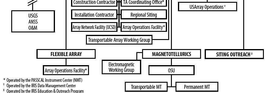
7 IRIS Structure and Management
8 Annual Governance Meeting Schedule Winter Board Intro, Annual Planning and Program Guidance Spring Standing Committees and CoCom Budget Planning Spring Board Budget Approval Bi-Annual Workshop Fall Standing Committees and Cocom Carry-over and long term planning Fall Board Long term planning Annual Membership Meeting
9 IRIS Management


10 Global Seismographic Network Uniform global coverage in cooperation with US Geological Survey and partners in the international Federation of Digital Seismograph Networks

11 Global Seismographic Network Falkland Islands Station (EFI) 150 GSN stations in unattended locations worldwide including remote oceanic islands and polar regions previously inaccessible regions of China and the former Soviet Union Integration with national and regional networks in many developing nations
, high resolution (24 bit) Continuous recording Real time telemetry at most sites Free and open data")
12 Global Seismographic Network IRIS-established standards for observatory instrumentation Broadband (3000 sec to 10 hz), high resolution (24 bit) Continuous recording Real time telemetry at most sites Free and open data access

13 Global Seismographic Network Supporting research on: Earthquake sources - uniform coverage at M=5; on scale for M=9+ Earth structure - whole Earth tomography Applications in earthquake and nuclear test monitoring


14 Great Earthquakes On scale recording of the M 9.3 Sumatra-Andaman Earthquake of Dec 26, 2004 First detailed observations of a great tsunami generating earthquake Complex 500 second rupture of 1600km fault


15 Deep Earth Structure 3-dimensional Earth tomography from surface and body waves Structure of mantle heterogeneity, subduction zones and core-mantle boundary

16 Program for the Array Seismic Studies of the Continental Lithosphere PASSCAL Instrument Center at New Mexico Tech, Socorro Field support, training and maintenance facilities

17 Program for the Array Seismic Studies of the Continental Lithosphere Portable instrumentation for use in NSF-funded research programs Collaborative, international, multi-institution, multi-disciplinary

18 Program for the Array Seismic Studies of the Continental Lithosphere Temporary field installations Deployments of 10 s to 100 s of instruments Experiments lasting from 1-2 weeks to 3 years

19 Program for the Array Seismic Studies of the Continental Lithosphere Supporting research on: high resolution structure of the crust and lithosphere applications in earthquake hazard assessment
 contributed data from US national and international sources user tools provide easy web-based access to all")
20 Data Management System IRIS Data Management Center Seattle Washington on-line access to complete 70 terabyte archive all data collected by IRIS programs (GSN, PASSCAL, USArray) contributed data from US national and international sources user tools provide easy web-based access to all data


21 Education and Outreach Intern Programs Museum Displays Distinguished Lecturers Classroom materials posters and one-pagers >20,000 copies distributed each year additional materials & activities available through the web

22 EarthScope / USArray Structure Evolution and Dynamics of the North American Continent NSF MREFC Project Construction Phase ~$200M USArray - seismology - IRIS Plate Boundary Observatory - geodesy - UNAVCO SAFOD - San Andreas Drilling - Stanford/USGS

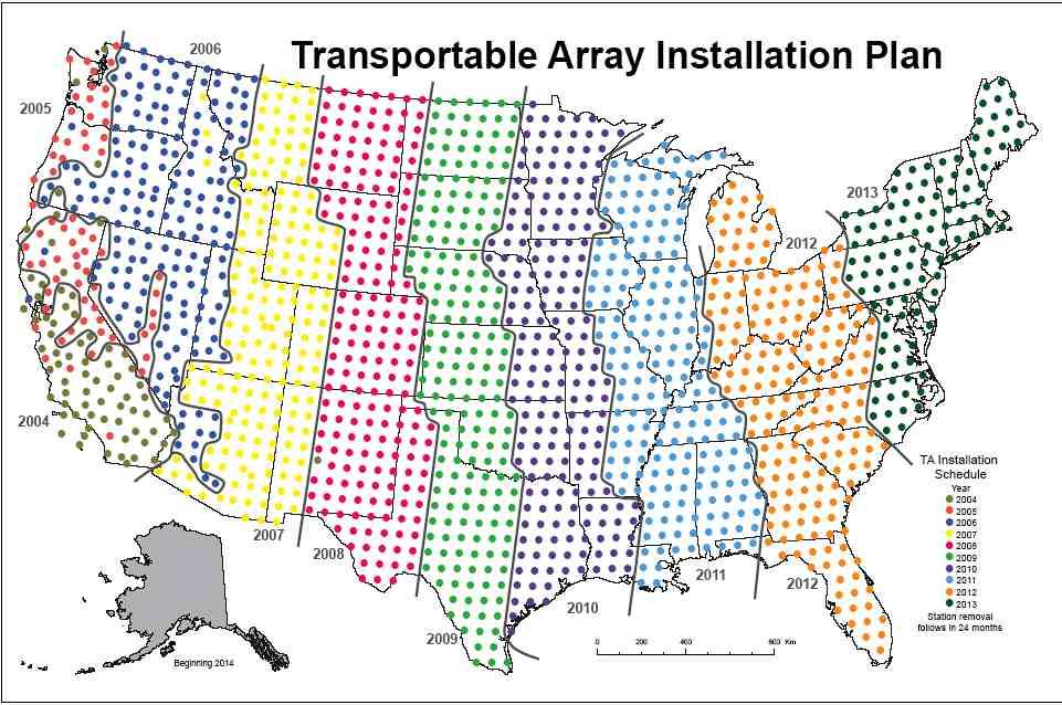
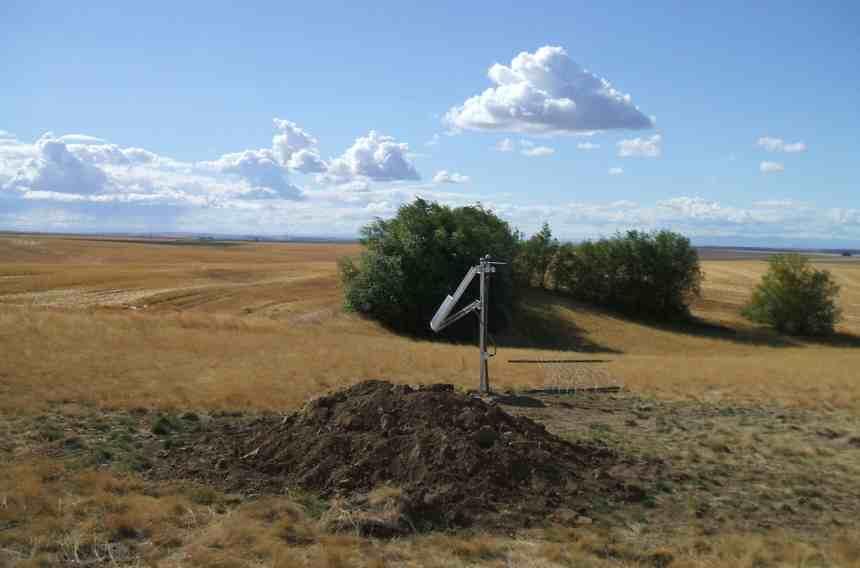
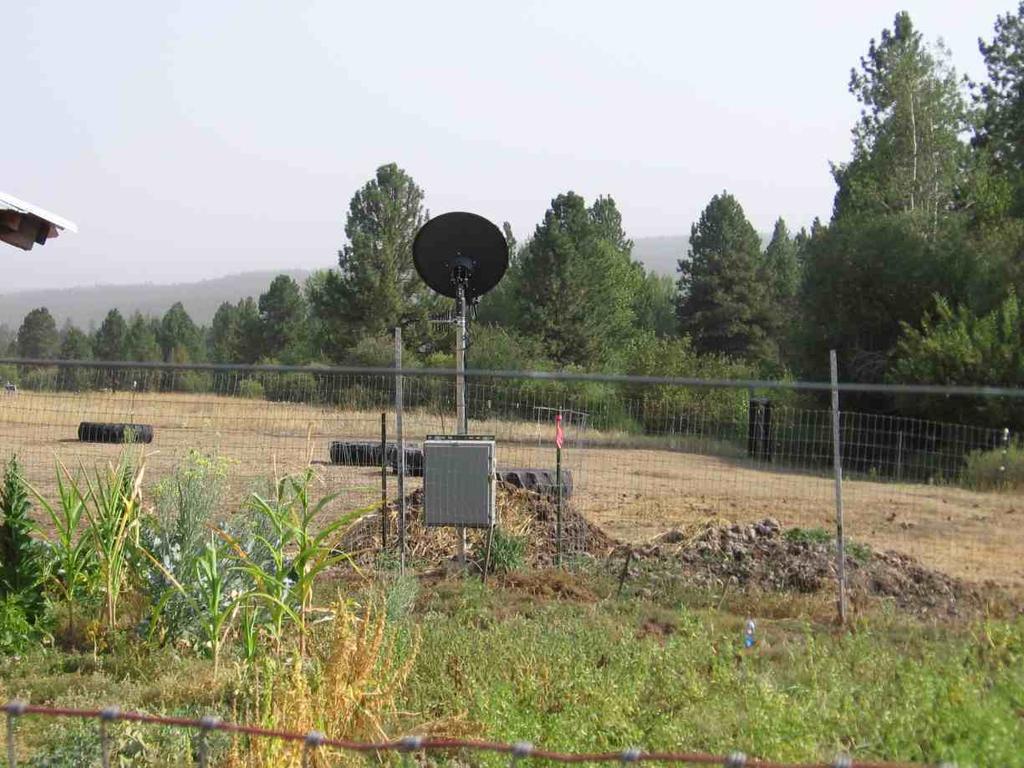
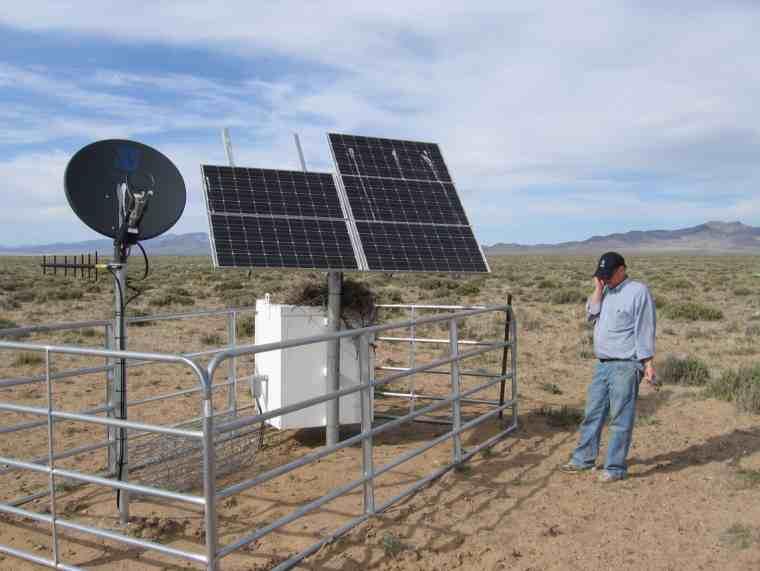
23 EarthScope / USArray USArray Transportable Array 1600 sites in 10 years 400 station sub-arrays 200 installations per year


24 Mission Applications - Global Seismicity USGS NEIC - Global Seismicity 2007 ~900 real time stations used by NEIC operations IRIS, NSF and USGS Collaboration in GSN Capitalization and O&M IRIS, FDSN and USGS Open data exchange USGS and NOAA Operational responsibility
 US National Security")

25 Mission Applications - Nuclear Test Monitoring and Research Comprehensive Test Ban Treaty International Monitoring System (IMS) US National Security DOD (AFTAC) IRIS/NSF, USGS, DOD and DOE Capitalization of GSN and PASSCAL Open GSN and PASSCAL data Applications in operation and research Restricted IMS data


26 IRIS Funding History NSF - EAR - Instrumentation and Facilities Primary stable core program funding NSF - MREFC and EAR EarthScope construction and operation NSF - MRI and Office of Polar Programs Polar instrumentation DOD/DOE - Capitalization of GSN and PASSCAL instrumentation Congressional special interest USGS Collaborative support for GSN operations
27 Science and Facilities A Partnership with NSF and the Research Community IRIS a non-profit, Consortium under Cooperative Agreement with NSF with Governance by its University members: implements facilities to support science Arm s length link between facilities and science NSF reviews and defines scientific programs IRIS provides facilities to support science NSF monitors IRIS plans and implementation IRIS works with NSF and the research community to: set priorities for facility development and evolution linked to new opportunities for research
28 NSF-IRIS Cooperative Agreement Important characteristics of a partnership in facility operation People, Ideas, Tools Flexibility Balance Stability Leverage Leadership Partnerships Science-driven facility evolution Science and Facilities Long-term investments in infrastructure 5-year Cooperative Agreements and review Annual plans and budgets Stable staffing Multi-use, multi-agency, multi-purpose IRIS core programs and special projects Community and intellectual drivers Science, observations and O&M National Agency (NSF, USGS, NOAA, DOE, DOD) Intramural - Consortium members International - FDSN, IMS, national systems Interdisciplinary - EarthScope, UNAVCO, SCEC
29 IRIS some reasons for success Planning Science Plan ---> Design Goals ---> Technical Specifications Flexibility and Responsiveness Feedback Community governance and participation Close interaction between research needs and facility growth Stability and Flexibility 5 year Cooperative Agreements Standards, Formats, Quality Control Adaptive to changing needs Competence Technical and managerial Staff Solid business and administrative practices
30 Some Lessons Learned Let Intellectual Drivers lead Set Standards and maintain Quality Provide free and open access to all data and services Differentiate between Facilities and Science Governance and Management Provide Competent and Responsive Management Business and legal structure Professional scientific and business staff Maintain Strong Communications and Feedback between Facilities and Science Governance and Management Community and Consortium Consortium and NSF Management and NSF
31
32 USArray Management
Earthquakes, Tsunamis and Nuclear Explosions: Open Data Exchange for Research and Monitoring in Seismology
 Earthquakes, Tsunamis and Nuclear Explosions: Open Data Exchange for Research and Monitoring in Seismology David Simpson IRIS Consortium Washington, DC Symposium on Data Sharing Plans for GEOSS and Benefits
T W E N T I E T. Twenty Years of Support for Seismological Research. The IRIS Consortium
 Y T W R A E N T I E T H A N N I V E S R Twenty Years of Support for Seismological Research The IRIS Consortium 1984 2004 Washington, DC 20005 Cover of the proposal that formed the basis for the 2001-2006
Seismic Recording Station AZ_PFO Summary Report
 Seismic Recording Station AZ_PFO Summary Report Thank you for hosting station AZ_PFO on your property. We hope that you find the enclosed report interesting. Your station is one of the 2000 USArray seismic
Seismic Recording Station TA_109C Summary Report
 Seismic Recording Station TA_109C Summary Report Thank you for hosting station TA_109C on your property. We hope that you find the enclosed report interesting. Your station is one of the 2000 USArray seismic
The EarthScope Geophysical Observatories. Slides courtesy Bob Woodward, Incorporated Research Institutions for Seismology (IRIS)
") The EarthScope Geophysical Observatories Slides courtesy Bob Woodward, Incorporated Research Institutions for Seismology (IRIS) 1 EarthScope Project Study the four dimensional structure and evolution of
The EarthScope Geophysical Observatories Slides courtesy Bob Woodward, Incorporated Research Institutions for Seismology (IRIS) 1 EarthScope Project Study the four dimensional structure and evolution of
USArray the first five years
 www.earthscope.org USArray the first five years USArray A Continental-Scale Seismic By the Numbers (2003 2008) More than 600 Transportable Array sites have been occupied and more than 535 permits acquired
DEPARTMENT OF GEOLOGY AND MINERAL INDUSTRIES WAYS & MEANS SUBCOMMITTEE ON NATURAL RESOURCES MARCH 2, 2017
 DEPARTMENT OF GEOLOGY AND MINERAL INDUSTRIES WAYS & MEANS SUBCOMMITTEE ON NATURAL RESOURCES MARCH 2, 2017 1 ABOUT DOGAMI AGENCY MISSION, VISION & GOALS 2 Lidar image of a stream network along the Umpqua
Alaska Earthquake Center. By Natalia A. Ruppert Seismic Network Manager
 Alaska Earthquake Center By Natalia A. Ruppert Seismic Network Manager Geophysical Institute, University of Alaska Fairbanks Alaska Earthquake Center mission and historical perspective! Regional seismic
Advantages of Regional and Global Data Exchange. Gavin Hayes U.S. Geological Survey, National Earthquake Information Center
 Advantages of Regional and Global Data Exchange Gavin Hayes U.S. Geological Survey, National Earthquake Information Center USGS NEIC Global Earthquake Response Area of responsibility => Global BUT - domestically,
Cornerstone Facilities. for Seismology and Earth Sciences
 Cornerstone Facilities for Seismology and Earth Sciences Proposal to NSF 2006 2011 I Project Description About the Cover From the innermost inner core, which influences the evolution of the magnetic field
The San Andreas Fault Observatory at Depth: Recent Site Characterization Studies and the 2.2-Km-Deep Pilot Hole
 The San Andreas Fault Observatory at Depth: Recent Site Characterization Studies and the 2.2-Km-Deep Pilot Hole Steve Hickman and Bill Ellsworth (USGS) Mark Zoback (Stanford University) and the Pre-EarthScope
2008 Monitoring Research Review: Ground-Based Nuclear Explosion Monitoring Technologies
 EXTENSION OF THE CAUCASUS SEISMIC INFORMATION NETWORK STUDY INTO CENTRAL ASIA Randolph Martin 1, Mary L. Krasovec 1, Eileen Vergino 2, and M. Nafi Toksöz 3 New England Research 1, Lawrence Livermore National
NESEC NEWS. Published by the Northeast States Emergency Consortium. Wakefield, Massachusetts
 Published by the Northeast States Emergency Consortium Wakefield, Massachusetts Connecticut Maine Massachusetts New Hampshire New Jersey New York Rhode Island Vermont Volume 21 Issue 4 www.nesec.org Winter
Background Document: Report of the Regional Committee of United Nations Global Geospatial Information Management for Asia and the Pacific
 Background Document: Report of the Regional Committee of United Nations Global Geospatial Information Management for Asia and the Pacific 1. Summary 1. This report highlights the activities carried out
Ministry of Health and Long-Term Care Geographic Information System (GIS) Strategy An Overview of the Strategy Implementation Plan November 2009
 Strategy An Overview of the Strategy Implementation Plan November 2009") Ministry of Health and Long-Term Care Geographic Information System (GIS) Strategy An Overview of the Strategy Implementation Plan November 2009 John Hill, Health Analytics Branch Health System Information
Ministry of Health and Long-Term Care Geographic Information System (GIS) Strategy An Overview of the Strategy Implementation Plan November 2009 John Hill, Health Analytics Branch Health System Information
The Canadian Ceoscience Knowledge Network. - A Collaborative Effort for Unified Access to Ceoscience Data
 The Canadian Ceoscience Knowledge Network - A Collaborative Effort for Unified Access to Ceoscience Data The Canadian Geoscience Knowledge Network A Collaborative Effort for Unified Access to Geoscience
DRAFT PROGRAM Registration of participants, welcome coffee, exhibition tour
 DRAFT PROGRAM 20 Feb 2018 09.00-10.00 Registration of participants, welcome coffee, exhibition tour 10.00 12.00 ROUND TABLE: INTERNATIONAL COOPERATION IN THE ARCTIC PROJECTS: CHALLENGES AND OPPORTUNITIES
SOUTH DAKOTA BOARD OF REGENTS. Academic and Student Affairs ******************************************************************************
 SOUTH DAKOTA BOARD OF REGENTS Academic and Student Affairs AGENDA ITEM: 7 C (4) DATE: June 28-30, 2016 ****************************************************************************** SUBJECT: New Minor:
CHAPTER 22 GEOGRAPHIC INFORMATION SYSTEMS
 CHAPTER 22 GEOGRAPHIC INFORMATION SYSTEMS PURPOSE: This chapter establishes the administration and use of to improve the quality and accessibility of Department s spatial information and support graphical
Strategic Plan
 2013-2015 Strategic Plan April 23, 2014 Introduction The Indiana Geographic Information Council's (IGIC) 2013-2015 Strategic Plan establishes a path of action to meet opportunities and challenges of applying
Magnitude 7.0 N of ANCHORAGE, ALASKA
 A magnitude 7.0 earthquake occurred just before 8:30 am local time 8 miles north of Anchorage at a depth of 40.9 km (25.4 miles). There are reports of major infrastructure damage and damage to many homes
State GIS Officer/GIS Data
 State GIS Officer/GIS Data This Act creates the position of state Geographic Information Systems (GIS) officer. The Act: requires the state GIS officer to adopt or veto the GIS data standards and a statewide
INTEGRATING GEOSPATIAL PERSPECTIVES IN THE ANTHROPOLOGY CURRICULUM AT THE UNIVERSITY OF NEW MEXICO (UNM)
") INTEGRATING GEOSPATIAL PERSPECTIVES IN THE ANTHROPOLOGY CURRICULUM AT THE UNIVERSITY OF NEW MEXICO (UNM) VERONICA ARIAS HEATHER RICHARDS JUDITH VAN DER ELST DEPARTMENT OF ANTHROPOLOGY MARCH 2005 INTEGRATING
INTEGRATING GEOSPATIAL PERSPECTIVES IN THE ANTHROPOLOGY CURRICULUM AT THE UNIVERSITY OF NEW MEXICO (UNM) VERONICA ARIAS HEATHER RICHARDS JUDITH VAN DER ELST DEPARTMENT OF ANTHROPOLOGY MARCH 2005 INTEGRATING
Plate Boundary Observatory the first five years
 www.earthscope.org Plate Boundary Observatory the first five years Plate Boundary Observatory A Continental-Scale, Integrated Geodetic By the Numbers (2003 2008) Installed 891 permanent Global Positioning
SM2.1/GD2.7/NH5.8/TS8.4, Large Earthquake and Tsunami Activity (co-organized), 13:30 17:00, Room B3
, 13:30 17:00, Room B3") SM Seismology Orals and PICOs MO1, 08:30 10:00 MO2, 10:30 12:00 MOL, 12:15 13:15 MO3, 13:30 15:00 MO4, 15:30 17:00 TU1, 08:30 10:00 Monday, 08 April SM1.2/AS4.13, Research and Development in Nuclear Explosion
SM Seismology Orals and PICOs MO1, 08:30 10:00 MO2, 10:30 12:00 MOL, 12:15 13:15 MO3, 13:30 15:00 MO4, 15:30 17:00 TU1, 08:30 10:00 Monday, 08 April SM1.2/AS4.13, Research and Development in Nuclear Explosion
FIG Asia Pacific Capacity Development Network
 FIG Asia Pacific Capacity Development Network Report to the 41th General Assembly FIG Congress 2018, Istanbul - Turkey Rob Sarib Chair FIG Asia Pacific Capacity Development Network (AP CDN) Story of the
ECONOMIC AND SOCIAL COUNCIL
 UNITED NATIONS E/CONF.102/3 ECONOMIC AND SOCIAL COUNCIL Nineteenth United Nations Regional Cartographic Conference for Asia and the Pacific Bangkok, 29 October 1 November 2012 Item 4 of the provisional
Weather Information for Surface Transportation (WIST): Update on Weather Impacts and WIST Progress
: Update on Weather Impacts and WIST Progress") Weather Information for Surface Transportation (WIST): Update on Weather Impacts and WIST Progress Samuel P. Williamson Office of the Federal Coordinator for Meteorological Services and Supporting Research
Weather Information for Surface Transportation (WIST): Update on Weather Impacts and WIST Progress Samuel P. Williamson Office of the Federal Coordinator for Meteorological Services and Supporting Research
158 Reducing Earthquake Losses
 ndex A Accelerographs, 64 Active control systems, 83-84 Active mass damping, 83 Active tendons, 83 Advocates, role of, 116 Air Force Office of Scientific Research, 133 Alaska, 42-43 Alquist-Priolo Act,
U.S. Geological Survey Agency Briefing for MAPPS Mark L. DeMulder Director, National Geospatial Program. March 12, 2013
 + U.S. Geological Survey Agency Briefing for MAPPS Mark L. DeMulder Director, National Geospatial Program March 12, 2013 + 3D Elevation Program (3DEP) National Leadership The National Enhanced Elevation
Business Continuity Planning (BCP)
") Business Continuity Planning (BCP) Eric Holdeman, Principal Why Have a Business Continuity Plan? } Bad things happen unexpectedly and pre-event planning is part of disaster preparedness } Your community
Business Continuity Planning (BCP) Eric Holdeman, Principal Why Have a Business Continuity Plan? } Bad things happen unexpectedly and pre-event planning is part of disaster preparedness } Your community
Magnitude 7.9 SE of KODIAK, ALASKA
 A magnitude 7.9 earthquake occurred at 12:31 am local time 181 miles southeast of Kodiak at a depth of 25 km (15.5 miles). There are no immediate reports of damage or fatalities. Light shaking from this
USGS National Geospatial Program Understanding User Needs. Dick Vraga National Map Liaison for Federal Agencies July 2015
 + USGS National Geospatial Program Understanding User Needs Dick Vraga National Map Liaison for Federal Agencies July 2015 + Topics 2 Background Communities of Use User Surveys National Map Liaisons Partnerships
EarthScope Facility Operation and Maintenance
 FACILITY OPERATION & MAINTENANCE OctOber 1, 2008 SepteMber 30, 2018 Proposal to the National Science Foundation March 2007 EarthScope Facility Operation and Maintenance October 1, 2008 September 30, 2018
PART A Project summary
 PART A Project summary A.1 Project identification Project title Project acronym Name of the lead partner organisation in English Specific objective Demonstrattion AF DAF Partner 1.1. Improving innovation
Southern California Earthquake Center. SCEC Annual Meeting. Palm Springs, California September 2016
 SCEC Annual Meeting Palm Springs, California 11-14 September 2016 Welcome to Palm Springs! Southern California SCEC Annual Meetings 707 pre-registrants 347 poster abstracts 211 first-time attendees (145
Night Comes to the Cumberlands and It s Awesome: Promoting Night Sky Conservation and Development in the Upper Cumberland
 Night Comes to the Cumberlands and It s Awesome: Promoting Night Sky Conservation and Development in the Upper Cumberland Jean Mercer Assistant Vice Chancellor for Research Office of Sponsored Programs
Training System and Information Network for Earthquake Disaster Mitigation. Taiki SAITO. Building Research Institute (BRI)
") 1 Training System and Information Network for Earthquake Disaster Mitigation Taiki SAITO Chief Research Engineer, International Institute of Seismology and Earthquake Engineering (IISEE), Building Research
1 Training System and Information Network for Earthquake Disaster Mitigation Taiki SAITO Chief Research Engineer, International Institute of Seismology and Earthquake Engineering (IISEE), Building Research
7.1 FIJI 1, :57:22 UTC
 A magnitude 7.1 earthquake struck 141 km (88 miles) northeast of Ndoi Island, Fiji, and 313 km (194 mi) west-northwest of Nuku alofa, Tonga according to the US Geological Survey, but there were no reports
IRIS Undergraduate Internship Orientation Week May 26 June 1, 2013 New Mexico Tech
 IRIS Undergraduate Internship Orientation Week May 26 June 1, 2013 New Mexico Tech Staff: Rick Aster (NMT) Greg Chavez (PIC) Gary Axen (NMT) Katie Foster (U. of Wyoming & Program Alumnus) Michael Hubenthal
TASC Transition Curriculum Project
 TASC Transition Curriculum Project MODULE 3: WORKSHOP 9 REVIEWING THE CROSS-CUTTING CONCEPTS INVOLVED IN SOLVING PROBLEMS PLACED ON STUDENTS IN TASC ABOUT DISCIPLINARY CORE IDEAS POSED IN THE PHYSICAL
GEON: Geosciences Network
 GEON: Geosciences Network A Research Project to Create Cyberinfrastructure for the Geosciences Dogan Seber San Diego Supercomputer Center, University of California, San Diego Objectives An in-depth look
Magnitude 8.2 NORTHWEST OF IQUIQUE, CHILE
 An 8.2-magnitude earthquake struck off the coast of northern Chile, generating a local tsunami. The USGS reported the earthquake was centered 95 km (59 miles) northwest of Iquique at a depth of 20.1km
Highlights from the 2014 AMS Washington Forum (AWF)
") Highlights from the 2014 AMS Washington Forum (AWF) Shawn Miller Chief Architect, JPSS CGS, Raytheon Company Chair, AMS Board on Economic Development (BEED) shawn_w_miller@raytheon.com Thomas Fahy Principal,
Highlights from the 2014 AMS Washington Forum (AWF) Shawn Miller Chief Architect, JPSS CGS, Raytheon Company Chair, AMS Board on Economic Development (BEED) shawn_w_miller@raytheon.com Thomas Fahy Principal,
NSDI Implementation. Milo Robinson FGDC. U. S. Policy OMB Circular A-16 From Global GSDI To Local Canadian/ U.S. Projects
 NSDI Implementation Milo Robinson FGDC U. S. Policy OMB Circular A-16 From Global GSDI To Local Canadian/ U.S. Projects Federal Geographic Data Committee (FGDC) A US Federal Interagency committee responsible
SEISMOLOGICAL FACILITIES FOR THE ADVANCEMENT OF GEOSCIENCE AND EARTHSCOPE. Proposal To NSF For Support Of VOLUME 1: October 1, 2013 September 30, 2018
 Volume 1 - Project Description and Scientific Justification Proposal To NSF For Support Of SEISMOLOGICAL FACILITIES FOR THE ADVANCEMENT OF GEOSCIENCE AND EARTHSCOPE October 1, 2013 September 30, 2018 VOLUME
Pushing the Standards Edge: Collaborative Testbeds to Accelerate Standards Development and Implementation
 Pushing the Standards Edge: Collaborative Testbeds to Accelerate Standards Development and Implementation Mark E. Reichardt President mreichardt@opengeospatial.org 31 October 2006 2006 Open Geospatial
Multi-station Seismograph Network
 Multi-station Seismograph Network Background page to accompany the animations on the website: IRIS Animations Introduction One seismic station can give information about how far away the earthquake occurred,
EXECUTIVE SUMMARY: EARTHCUBE WORKSHOP RESULTS (Michael Gurnis, Caltech: Oct , 2012)
") EXECUTIVE SUMMARY: EARTHCUBE WORKSHOP RESULTS (Michael Gurnis, Caltech: Oct. 29-30, 2012) Earth Cube Workshop Title: EarthCube End-User Domain Workshop for EarthScope Introduction: Supported by the NSF,
EXECUTIVE SUMMARY: EARTHCUBE WORKSHOP RESULTS (Michael Gurnis, Caltech: Oct. 29-30, 2012) Earth Cube Workshop Title: EarthCube End-User Domain Workshop for EarthScope Introduction: Supported by the NSF,
Cascadia megathrust earthquakes: reducing risk through science, engineering, and planning
 Cascadia megathrust earthquakes: reducing risk through science, engineering, and planning NSF Hazards SEES EAR-1331412 Urban Science and Engineering Workshop 21 July 2014 Everything to do with M9 Cascadia
Section 2. Indiana Geographic Information Council: Strategic Plan
 Section 2. Indiana Geographic Information Council: Strategic Plan Introduction A geographic information system (GIS) is an automated tool that allows the collection, modification, storage, analysis, and
Magnitude 8.2 FIJI. A magnitude 8.2 earthquake occurred km (226.7 mi) E of Suva, Fiji at a depth of km (350 miles).
 E of Suva, Fiji at a depth of km (350 miles).") A magnitude 8.2 earthquake occurred 364.8 km (226.7 mi) E of Suva, Fiji at a depth of 563.4 km (350 miles). There is no risk of a tsunami from an earthquake at this depth. Images courtesy of Google The
A magnitude 8.2 earthquake occurred 364.8 km (226.7 mi) E of Suva, Fiji at a depth of 563.4 km (350 miles). There is no risk of a tsunami from an earthquake at this depth. Images courtesy of Google The
SUNYOUNG (SUNNY) PARK
 PARK") SUNYOUNG (SUNNY) PARK Department of Earth and Planetary Sciences, Harvard University, 20 Oxford Street, Cambridge, MA 02138, USA +1 (617) 495-1172 sunyoungpark01@fas.harvard.edu http://seismology.harvard.edu/people/park.html
SUNYOUNG (SUNNY) PARK Department of Earth and Planetary Sciences, Harvard University, 20 Oxford Street, Cambridge, MA 02138, USA +1 (617) 495-1172 sunyoungpark01@fas.harvard.edu http://seismology.harvard.edu/people/park.html
Building earthquake early warning for the west coast. Ken Creager Professor of Earth and Space Sciences University of Washington
 Building earthquake early warning for the west coast Ken Creager Professor of Earth and Space Sciences University of Washington How Earthquake Early Warning works: P-waves S-waves 3-fold way of Earthquake
Earthscope in the Northern Rockies Workshop
 Earthscope in the Northern Rockies Workshop Co-conveners: David Foster - University of Florida Paul Mueller - University of Florida David Mogk - Montana State University EarthScope in the Northern Rockies
Originally published as:
 Originally published as: Henstock, T., McNeill, L., Dean, S., Barton, P., Tilmann, F., Rietbrock, A., Robinson, D., Gulick, S., Austin, J., Djajadihardja, Y., Natawidjaja, D., Permana, H., Bonneville,
OC Enterprise GIS. Kevin Hills, PLS Cameron Smith, GISP. OC Survey
 OC Enterprise GIS Kevin Hills, PLS Cameron Smith, GISP OC Survey Discussion Points Background & Organizational Structure of OCPW Past practices prior to Enterprise Wide GIS License (ELA) Participating
UN-GGIM: Strengthening Geospatial Capability
 Fifth Plenary Meeting of UN-GGIM: Europe Brussels, 6-7 June 2018 UN-GGIM: Strengthening Geospatial Capability Walking the talk to leave no one behind Greg Scott, UN-GGIM Secretariat Environmental Statistics
IRIS Seismographs in Schools Program
 IRIS Seismographs in Schools Program www.iris.edu IRIS (the Incorporated Research Institutions for Seismology, an NSFfunded research and education consortium in seismology) announces a program for K-12
History of International Training in Seismology and Earthquake Engineering at IISEE
 History of International Training in Seismology and Earthquake Engineering at IISEE Activities of International Institute of Seismology and Earthquake Engineering (IISEE), BRI - Training for young researchers/engineers
NOAA Surface Weather Program
 NOAA Surface Weather Program Maintenance Decision Support System Stakeholder Meeting #9 Jim O Sullivan NOAA Surface Weather Program Manager NWS Office of Climate, Water, and Weather Services September
What s the problem? A Modern Odyssey in Search of Relevance. The search for relevance. Some current drivers for new services. Some Major Applications
 A Modern Odyssey in Search of Relevance FIG Working Week, Athens, 24 May 2004 Paul Kelly ANZLIC Executive Director The search for relevance 1. New expectations for spatial services 2. Are we ready to meet
Meeting at a Glance May 2018
 Meeting at a Glance 14 18 May 2018 Monday 14 May Tuesday 15 May Wednesday 16 May Thursday 17 May Friday 18 May 7:30 a.m. 3:30 p.m. Board of Directors Meeting Orchid C Noon 4 p.m. Workshop: Getting Published
Evaluation Module 5 - Class B11 (September 2012) Responsible for evaluation: Dorte Nielsen / Cristina Lerche Data processing and preparation of
 Responsible for evaluation: Dorte Nielsen / Cristina Lerche Data processing and preparation of") 2011 Evaluation Module 5 - Class B11 (September 2012) Responsible for evaluation: Dorte Nielsen / Cristina Lerche Data processing and preparation of report: Cristina Lerche Contents Contents... 2 Questions
2011 Evaluation Module 5 - Class B11 (September 2012) Responsible for evaluation: Dorte Nielsen / Cristina Lerche Data processing and preparation of report: Cristina Lerche Contents Contents... 2 Questions
Water Data Sharing an Update
 Water Data Sharing an Update By David R. Maidment Leader, CUAHSI Hydrologic Information System Project and Director, Center for Research in Water Resources, University of Texas at Austin Prepared for Subcommittee
Training System and Information Network for Earthquake Disaster Mitigation. Taiki SAITO. Building Research Institute (BRI)
") Asian Science and Technology Forum Tsukuba Seminar, 2007.10.03, Tsukuba Training System and Information Network for Earthquake Disaster Mitigation Taiki SAITO Chief Research Engineer, International Institute
Asian Science and Technology Forum Tsukuba Seminar, 2007.10.03, Tsukuba Training System and Information Network for Earthquake Disaster Mitigation Taiki SAITO Chief Research Engineer, International Institute
Research infrastructures in FP7: Seismology and Geophysics
 Research infrastructures in FP7: Seismology and Geophysics Domenico Giardini, ETHZ Internation Workshop on Disaster Risk Reduction Bruxelles 29-30 October, 2009 EC FP7 2007-2013 Seven-year targeted program
Economic and Social Council
 United Nations Economic and Social Council Distr.: General 18 July 2016 Original: English Committee of Experts on Global Geospatial Information Management Sixth session New York, 3-5 August 2016 Item 2
UNAVCO COMMUNITY AND FACILITY PROPOSAL GEODESY ADVANCING EARTH SCIENCE RESEARCH
 2008-2012 UNAVCO COMMUNITY AND FACILITY PROPOSAL GEODESY ADVANCING EARTH SCIENCE RESEARCH About the Cover The cover shows the three primary activities of the UNAVCO facility requested in this proposal.
JCOMM-CHy Coastal Inundation Forecasting Demonstration Project (CIFDP)
") WMO World Meteorological Organization Working together in weather, climate and water JCOMM-CHy Coastal Inundation Forecasting Demonstration Project (CIFDP) Coastal Flooding & Vulnerable Populations Coastal
WMO World Meteorological Organization Working together in weather, climate and water JCOMM-CHy Coastal Inundation Forecasting Demonstration Project (CIFDP) Coastal Flooding & Vulnerable Populations Coastal
A BROADBAND SEISMIC EXPERIMENT IN YUNNAN, SOUTHWEST CHINA. Sponsored by Defense Threat Reduction Agency. Contract No.
 A BROADBAND SEISMIC EXPERIMENT IN YUNNAN, SOUTHWEST CHINA Wenjie Jiao, 1 Winston Chan, 1 and Chunyong Wang 2 Multimax Inc., 1 Institute of Geophysics, China Seismological Bureau 2 Sponsored by Defense
Global Spatial Data Infrastructure Association
 http://www.gsdi.org Global Spatial Data Infrastructure Association a global forum to support exchange of ideas and encourage joint activities at the global level Members: Think global, act local Organization:
NGO potential as a stakeholder within processes of developing the NSDI
 and 7th Cartography and Geoinformation Conference NGO potential as a stakeholder within processes of developing the NSDI Luka Jovičić, MSc. Industrial Engineering representative market NGO status needs
Briefing. H.E. Mr. Gyan Chandra Acharya
 Briefing by H.E. Mr. Gyan Chandra Acharya Under-Secretary-General and High Representative for the Least Developed Countries, Landlocked Developing Countries and Small Island Developing States Briefing
Spatial Data Availability Energizes Florida s Citizens
 NASCIO 2016 Recognition Awards Nomination Spatial Data Availability Energizes Florida s Citizens State of Florida Agency for State Technology & Department of Environmental Protection Category: ICT Innovations
Distributed Data and Grid Computing for Inquiry based Science Education and Outreach
 Distributed Data and Grid Computing for Inquiry based Science Education and Outreach Eric Myers LIGO Hanford Observatory Hanford, Washington BOINC in Research, Science, and Education 1st East Coast BOINC
Strategic Planning for the Arts
 Strategic Planning for the Arts Summary of Online Surveys Buena Vista Conference Center December 16, 2009 Focus Groups - Overview Six focus groups conducted in September and early October Six to eight
What can I do with a major in Earth Information Science?
 Lewis-Clark State College offers a Bachelor of Arts or Science Degree in Earth Information Science through the Natural Sciences and Mathematics Division. You can learn more about the Natural Sciences and
California GIS Strategic Plan Phase 2: Regional Participation. Generic All Workshops CA
 California GIS Strategic Plan Phase 2: Regional Participation Generic All Workshops CA Collaboratives Represented Today? Bay Area Regional GIS Council Central Coast Joint Data Committee Channel Islands
ShakeAlert Earthquake Early Warning
 ShakeAlert Earthquake Early Warning Doug Given USGS, Pasadena Earthquake Program, Early Warning Coordinator 10 seconds 50 seconds 90 seconds USGS Earthquake Hazard Responsibilities USGS has the lead federal
NOAA S2S Planning. Dave DeWitt Fred Toepfer
 NOAA S2S Planning Dave DeWitt Fred Toepfer 1 Agenda 1. Brief synopsis of The Weather Research and Forecasting Act of 2017 2. Report to Congress a. Timeline b. Process c. Document Outline 3. Some Preliminary
Major Opportunities in Spatial Data Infrastructure Communities
 Major Opportunities in Spatial Data Infrastructure Communities Bas Kok President GSDI June 17 th 2008 FIG Working Week: Integrating Generations 14-19 June 2008 Stockholm, Sweden http://www.gsdi.org 1 GSDI
Himawari-8 BUFR Development for Winds Processing and Radiances Cloud Mask, Cloud Phase, Cloud Height
 Sandy Supplemental Grant Recipient Quarterly Progress Report Himawari-8 BUFR Development for Winds Processing and Radiances Award Number: NA14NES4830006 The National Oceanic and Atmospheric Administration
CONFERENCE STATEMENT
 Final draft CONFERENCE STATEMENT We, the elected representatives of Canada, Denmark/Greenland, the European Parliament, Finland, Iceland, Norway, Russia, Sweden and the United States of America; In collaboration
2008 Monitoring Research Review: Ground-Based Nuclear Explosion Monitoring Technologies
 EXTENSION OF THE CAUCASUS SEISMIC INFORMATION NETWORK STUDY INTO CENTRAL ASIA Randolph Martin 1, Mary L. Krasovec 1, Eileen Vergino 2, and M. Nafi Toksöz 3 New England Research 1, Lawrence Livermore National
CEETEP Related Digital Resources
 CEETEP Related Digital Resources The resources on the CEETEP DVD and USB drive include many items developed by or in collaboration with other organizations. Here we overview some of the partner and related
The SCEC Planning Cycle
 The SCEC Planning Cycle Director Recommends to Agencies (March) Presentation to BoD (February) Leadership Retreat (June) Science Plan Development (Summer) Annual Meeting; Science Plan Input (September)
New Progress of SinoProbe:
 New Progress of SinoProbe: Deep Exploration in China, 2008-2012 Shuwen DONG, Tingdong LI, et al. Chinese Academy of Geological Sciences Beijing 100037 China Background of Deep Exploration in World USA
Grand Challenges in GIScience: UCGIS experiences
 Grand Challenges in GIScience: UCGIS experiences 2006-2010 Tim Nyerges University of Washington University Consortium of Geographic Information Science (UCGIS) AAG Annual Meeting April 17, 2010 Outline
2018/1 The integration of statistical and geospatial information. The Regional Committee of UN-GGIM: Americas:
 The following are the conclusions and recommendations of the Regional Committee of the United Nations on Global Geospatial Information Management for the Americas, during its Fifth Session, Thursday 8
2018 ESRI Education Summit. San Diego. California. Sunday July 8 th 2018 Harper College, Palatine, Illinois, USA Dr. Tong Cheng (Biology), Dr.
, Dr.") 2018 ESRI Education Summit. San Diego. California. Sunday July 8 th 2018 Harper College, Palatine, Illinois, USA Dr. Tong Cheng (Biology), Dr. James Gramlich (Sociology), Mukila Maitha (Geography), Dr.
2018 ESRI Education Summit. San Diego. California. Sunday July 8 th 2018 Harper College, Palatine, Illinois, USA Dr. Tong Cheng (Biology), Dr. James Gramlich (Sociology), Mukila Maitha (Geography), Dr.
Magnitude 7.5 NEW BRITAIN REGION, PAPUA NEW GUINEA
 A magnitude 7.5 earthquake struck off the eastern coast of Papua New Guinea on Tuesday, approximately 130 km (81 mi) southsouthwest of Kokopo at a depth of 42 km (26.1 mi). There are reports of some structural
Frontiers in regional-scale seismology and the synergy between seismological and geodetic facilities and capacity building
 Frontiers in regional-scale seismology and the synergy between seismological and geodetic facilities and capacity building overview of leading edge research and future facility needs at regional scales
NEES/IRIS/USGS Workshop
 George E. Brown, Jr. Network for Earthquake Engineering Simulation (NEES) Program nees@utexas: Cooperative and Outreach Opportunities/Examples NEES Consortium Annual Meeting Kenneth H.Stokoe, II May 20,
Magnitude 7.5 PALU, INDONESIA
 A magnitude 7.5 earthquake occurred 80.8 km (50.2 mi) north of Palu, Indonesia at a depth of 10 km (6.2 miles). This earthquake triggered a tsunami with wave heights up to 2 m (6.6 ft) that an official
CONFERENCE STATEMENT
 CONFERENCE STATEMENT We, the elected representatives from Canada, Denmark/Greenland, Finland, Iceland, Norway, Russia, Sweden and the United States of America; In collaboration with the indigenous peoples
Assistant Professor, University of Zagreb (Faculty of Mining, Geology and Petroleum Engineering)
") Proposal of Adriatic-Balkan ICL Network 1. Name of Network Adriatic-Balkan ICL Network 2. Name of Proposer Dr. Snježana Mihalić and Prof. Željko Arbanas Affiliation: position Dr. Snježana Mihalić Assistant
Proposal of Adriatic-Balkan ICL Network 1. Name of Network Adriatic-Balkan ICL Network 2. Name of Proposer Dr. Snježana Mihalić and Prof. Željko Arbanas Affiliation: position Dr. Snježana Mihalić Assistant
Strategic Plan for the Geospatial Teaching, Research, and Outreach in CNR. The CNR Geospatial Steering Committee, March 31, 2008
 Strategic Plan for the Geospatial Teaching, Research, and Outreach in CNR The CNR Geospatial Steering Committee, March 31, 2008 Current Mission for the Geospatial Learning Center Established in 1995, the
GGOS. Global Geodetic Observing System. Carey Noll NASA GSFC (on behalf of GGOS) WDS Forum September 11, 2016
 WDS Forum September 11, 2016") https://ntrs.nasa.gov/search.jsp?r=20160011397 2018-12-07T18:04:29+00:00Z GGOS Global Geodetic Observing System Carey Noll NASA GSFC (on behalf of GGOS) WDS Forum September 11, 2016 Global Geodetic Observing
https://ntrs.nasa.gov/search.jsp?r=20160011397 2018-12-07T18:04:29+00:00Z GGOS Global Geodetic Observing System Carey Noll NASA GSFC (on behalf of GGOS) WDS Forum September 11, 2016 Global Geodetic Observing
The Vision of a Polar Observing System - Seismology
 The Vision of a Polar Observing System - Seismology Andy Nyblade, Dept. of Geosciences, Penn State University Autonomous Polar Observing Systems Workshop, Sept 30, 2010 Outline Why do we need a polar obs.