Cooperation for ecosystem based planning of the marine. Project leader: Jens Perus. Projectperiod june 2011-oct 2014 Budget: 1 M
|
|
|
- Alexandra McKinney
- 5 years ago
- Views:
Transcription
1 Cooperation for ecosystem based planning of the marine environment using GIS Project leader: Jens Perus Projectperiod june 2011-oct 2014 Budget: 1 M
2 Aim of SeaGIS The overarching aim of SeaGIS is to produce an increased knowledge base and make it more accessible in order to increase the possibilities of a coordination of ecosystembased regional holistic planning of marine areas and create a common platform for knowledge storing, planning and future decision making in the Kvarken region.


3 Quark region SE: 4 municipalities FI: 12 municipalities Welt-atlas.de Different sizes different prepardness EEZ EEZ

4 Shipping route Windpower park

5 The Quark Data from Planbothnia-project - Natura Fish catches - Wind energy - UNESCO sites - Spawning areas - Fairways - Cables - Harbours - Military - Tourism - Bird areas - Seal protection areas - Risk of oil spills -
6 Development of a transregional GIS-based knowledge platform for storing of data and analysing different marine planning situations. Tool for commucation of errands and projects between public, endusers, sectors and responsible planning administrations. Thorough pilot-testing on different planning scenarios and scales of the developed planning data found in GIS-based knowledge platform Local, regional and transboundary Support FI-SE implementation of EU MSD in a common sea area in the Quark


7 The platform Bilingual (Finnish, Swedish) Harmonized styling between corresponding FI-SE data Transboundary Open & accessible User-friendly Meets INSPIRE Functions i multiple coordinate systems Contains ~550 GIS layers out of which 300 visible Allows download of GISdata Do not consume WMS, but exports the service Functions as a tool for communication between end-users Can be used for requesting geographical observations or information from public over internet

8 content Measure -distances -areas Choose -by point, line or area Search -point, line, area -text Tools -Coordinates - Show - Go to - Check -Map contrast Log on Layer control Copyright Themes: -Planning and strategies -Cultural environment and recreation -Industry and infrastructure -Nature protection -Environmental status -Biology -Landscape facts Time series Print -adjust and zoom in printout window Save User


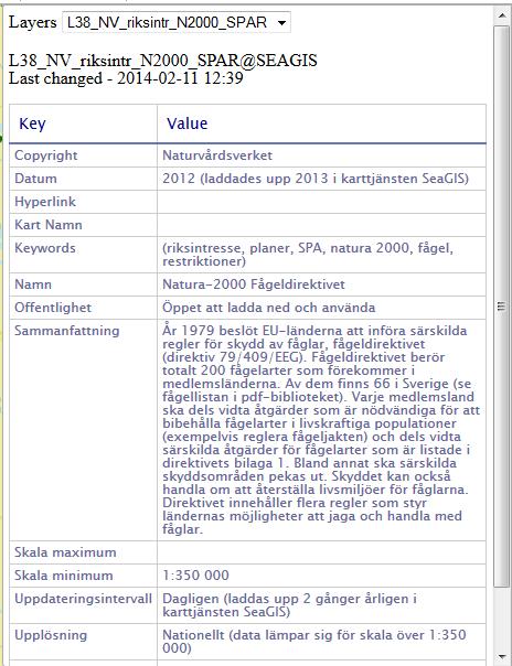
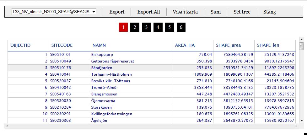
9 Make whole layer visible Natura 2000

10 Errands or communication between administrations, municipalities or with the public e.g. Propose new recreation areas Mark your proposed area - point, line, polygon Description of your errand or question All data in platform available for support Possible to pre-mark important data sheets relevant to question at hand Explain your proposal (e.g. sailing area, jet-ski area, scuba-diving, canoeing, scenic view, sport-fishing, other, etc. Save and it is available to others in the errand to have a look at
11 Administration 4-5 organisations with full administration rights (2-3 per country) Can upload/update GIS-data Make errands / GISsurveys Cost - ~10 000euro/year Platform basis built Good foundation for geographicla expansion to neigbouring regions
12 Problems Had to obmit data due to request for money for delivery Data owners choose not to show data, due to low confidence in accuracy Classified data (settle for coarser resolution) Transformations of data Coordinate systems
13 Sucesses Great tech-support from platform-consultants Allowed us to evolve from original ideas Low costs for upholding system Easy administration Public communication tool Serve tourism? Regional Helcom HUB-model with riskanalysis Diverse content (social, cultural, environment) in high-resolution environment

14 SeaGIS- a best practise


15 Consortium Lead partner: Centres for Economic Development, Transport and the Environment in southern Ostrobothnia Partners: Åbo Akademi University University of Vaasa County administrative board of Västerbotten Umeå University IGIS Metsähallitus Cooperating with: Kvarken Council, Regional Council of Ostrobothnia, Region Västerbotten, Finnish Transport Safety Agency, Municipalities in Finland and Sweden.

16 Thank you for your attention! For more information or questions, contact:
Cooperation for ecosystem based planning of the marine environment using GIS Project leader: Jens Perus
 Cooperation for ecosystem based planning of the marine environment using GIS http://seagis.org Project leader: Jens Perus Projectperiod june 2011-oct 2014 Budget: 1 M Aim of SeaGIS The overarching aim
Additional information (material for interactions and analysis chapter) to document 3/1, the PLAN BOTHNIA MSP Assessment
 to document 3/1, the PLAN BOTHNIA MSP Assessment") Co-Financed Under European Integrated Maritime Policy PLAN BOTHNIA MSP 2/2011 MSP Assessment Add 1 PLAN BOTHNIA MSP 2 Uppsala, Sweden June 14-15 2011 Agenda Item 3 PLAN BOTHNIA MSP Assessment Document
Co-Financed Under European Integrated Maritime Policy PLAN BOTHNIA MSP 2/2011 MSP Assessment Add 1 PLAN BOTHNIA MSP 2 Uppsala, Sweden June 14-15 2011 Agenda Item 3 PLAN BOTHNIA MSP Assessment Document
Country Fiche Sweden Updated May 2018
 Country Fiche Sweden Updated May 2018 1. General information 2 the territorial sea (12-nm zone) 70,000 km2 the Exclusive Economic Zone 60,000 km2 the EEZ is limited to the central line between adjacent
Marine Spatial Planning as an important tool for implementing the MSFD
 Marine Spatial Planning as an important tool for implementing the MSFD Risto Kalliola Tallinn, Nov. 16 th 2012 DEPARTMENT OF GEOGRAPHY AND GEOLOGY University of Turku, Finland Ten principles to provide
PLAN BOTHNIA MARE/2009/16
 PLAN BOTHNIA MARE/2009/16 Hermanni Backer Project Manager HELCOM Secretariat Partner Kick-Off Meeting Nordregio, Stockholm December 16 2010 Photo: Elena Bulycheva PLAN BOTHNIA MARE/2009/16 Co-financed
Marine Spatial Planning in the Baltic Sea Region
 Marine Spatial Planning in the Baltic Sea Region Towards coherence and cross-border solutions in Baltic Maritime Spatial Plans Coordinator & Project manager Dr Ingela Isaksson Swedish Agency for Marine
Maritime Spatial Planning: Transboundary Cooperation in the Celtic Seas Looking Ahead
 Maritime Spatial Planning: Transboundary Cooperation in the Celtic Seas Looking Ahead Looking ahead MSP in the context of the European Maritime and Fisheries Fund (EMFF) and beyond SIMCelt Final Conference
Maritime Spatial Planning Framework Directive Supported by INSPIRE
 Maritime Spatial Planning Framework Directive Supported by INSPIRE Andrej Abramić, Vanda Nunes de Lima, Paul Smits, Emanuele Bigagli, Chris Schubert European Commission Joint Research Centre Institute
Country Fiche Estonia
 Country Fiche Estonia Updated October 2017 1. General information Size of internal waters (to the baseline) and territorial sea (12-nm zone from the baseline) approximately 25 200 km 2. Exclusive economic
Natura 2000 in the marine environment: state of implementation and next steps
 Life on the blue planet: biodiversity research and the new European marine policies EPBRS European Platform on Biodiversity Research Strategy Porto, Portugal 7-9 November 2007 Natura 2000 in the marine
Education in Maritime Spatial Planning European Maritime Days May 22, 2012 Gothenburg
 Education in Maritime Spatial Planning European Maritime Days May 22, 2012 Gothenburg Paula Lindroos, director Baltic Centre for Sustainable Development Uppsala University BUP in Summary A regional university
Maritime Spatial Planning in the Baltic Sea Region
 Maritime Spatial Planning in the Baltic Sea Region Talis Linkaits Head of VASAB Secretariat 20 May 2015 Helsinki A cooperation of ministers of the 11 Baltic Sea Region countries responsible for spatial
1. Baltic SCOPE Towards coherence and cross-border solutions in Baltic Maritime Spatial Plans
 NSHC 32th Conference Explanatory Note Dublin, Ireland Item E.2 MSP 21-23 June 2016 Germany Cross border MSP for the EEZ, a case study from the Baltic Sea The Federal Maritime and Hydrographic Agency of
The Baltic Sea Region Maritime Spatial Planning Data Expert Sub-group. First Report 2015/2016/
 The Baltic Sea Region Maritime Spatial Planning Data Expert Sub-group First Report 2015/2016/2017 21.04.2017. Contents 1. Glossary 2 2. Introduction. 3 3. MSP Data. 5 3.1. Input Data. 5 3.2 Output Data.
Country Fiche Estonia
 Country Fiche Estonia Deleted: October Updated May 2018 Deleted: 7 1. General information Size of internal waters (to the baseline) and territorial sea (12-nm zone from the baseline) approximately 25 200
BURGAS CASE STUDY: LAND-SEA INTERACTIONS. Dr. Margarita Stancheva
 BURGAS CASE STUDY: LAND-SEA INTERACTIONS Dr. Margarita Stancheva Name of presentation NEED FOR COHERENCE BETWEEN LAND AND SEA ACTIVITIES Name presenter Burgas is the fourth largest city in Bulgaria and
Marine Spatial Planning Experience from Mecklenburg-Vorpommern (Germany) By Susan Toben
 By Susan Toben") Marine Spatial Planning Experience from Mecklenburg-Vorpommern (Germany) By Susan Toben Ministry of Transport, Building and Regional Development Mecklenburg Vorpommern PlanCoast Lead Partner Administrative
Marine Spatial Planning Experience from Mecklenburg-Vorpommern (Germany) By Susan Toben Ministry of Transport, Building and Regional Development Mecklenburg Vorpommern PlanCoast Lead Partner Administrative
The story of sharing environmental data
 The story of sharing environmental data Kallio, Pyhälahti, Harju, Teiniranta, Lahtinen, Finnish Environment Institute SYKE OKFestival, Finnish Open Data, 18. Sep 2012 Contents Call for environmental knowledge
BalticBOOST Appendix 1, WP 3.3 Deliverable 1 Final report 14 February 2017
 Theme 1: Biodiversity This is a deliverable from the BalticBOOST project that was coordinated by HELCOM and co-financed by the European Union in 2015-2016 as part of the programme DG ENV/MSFD Action Plans/2016.
Towards coherent maritime spatial planning in the Baltic Sea Region, transnational and project perspective Talis Linkaits Head of VASAB Secretariat
 3 June 2013 Riga PartiSEApate Workshop MSP as Tool for Underwater Cultural Heritage Management in the Baltic Sea Towards coherent maritime spatial planning in the Baltic Sea Region, transnational and project
Marine Spatial Planning (MSP): A practical approach to ecosystembased
: A practical approach to ecosystembased") Marine Spatial Planning (MSP): A practical approach to ecosystembased management Erik Olsen, Institute of Marine Research, Norway Fanny Douvere, International Oceanographic Commission Overview Why we need
Marine Spatial Planning (MSP): A practical approach to ecosystembased management Erik Olsen, Institute of Marine Research, Norway Fanny Douvere, International Oceanographic Commission Overview Why we need
Arctic Spatial Data Infrastructure Enabling Access to Arctic Location-Based Information
 Arctic Spatial Data Infrastructure Enabling Access to Arctic Location-Based Information Arctic SDI Side Event Co-Chairs: Arvo Kokkonen Arctic SDI Board Chair & Director General, National Land Survey of
Identification of maritime spatial planning best practices in the Baltic Sea Region and other EU maritime regions
 Identification of maritime spatial planning best practices in the Baltic Sea Region and other EU maritime regions PLAN BOTHNIA Baltic Sea Region Stakeholder Meeting Jacek Zaucha, Magdalena Matczak Two
The Danish Maritime Spatial Data Infrastructure (MSDI) Geodata of the Sea
 Geodata of the Sea") MSDI/MSP The Danish Maritime Spatial Data Infrastructure (MSDI) Geodata of the Sea Components of an infrastructure: DATA - metadata, datasets FUNCTIONALITY - spatial data services, web services and other
MSDI/MSP The Danish Maritime Spatial Data Infrastructure (MSDI) Geodata of the Sea Components of an infrastructure: DATA - metadata, datasets FUNCTIONALITY - spatial data services, web services and other
Institute of Statistical and Geographical Information of Jalisco State Subnational Statistical and Geographical System India.
 Institute of Statistical and Geographical Information of Jalisco State Subnational Statistical and Geographical System India. January 2017 Subnational Statistical and Geographical System National Statistical
BURGAS CASE STUDY: LAND-SEA INTERACTIONS
 BURGAS CASE STUDY: LAND-SEA INTERACTIONS Dr. Margarita Stancheva IO-BAS, Bulgaria Name of presentation CROSS BORDER MARITIME SPATIAL PLANNING IN THE BLACK SEA ROMANIA AND BULGARIA (MARSPLAN BS) Project
MARINE PLANNING IN THE NETHERLANDS
 MARINE PLANNING IN THE NETHERLANDS Hermien Busschbach Ministry of Transport, Public Works and Water Management (DG Water) Bremen, 2 May 2007 Marine Planning in the Netherlands OUTLINE policy context; international
Appropriation Directions for 2007
 INSPIRE in Sweden An Important Part of the National Geodata Strategy Monica Lagerqvist Nilsson Appropriation Directions for 2007 A commission to investigate the necessity to adjust the Swedish legislation
Baltic Marine Environment Protection Commission
 Baltic Marine Environment Protection Commission Maritime Group Klaipeda, Lithuania, 23-25 November 2015 MARITIME 15-2015 Document title FAMOS Finalising Surveys for the Baltic Motorways of the Sea Code
INDICATORS FOR INTEGRATED COASTAL ZONE MANAGEMENT (ICZM)
") IOC UNESCO / Leader Task 4.1 Contact Francesca Santoro, Julian Barbiere E-mail: f.santoro@unesco.org, j.barbiere@unesco.org Phone: +33 1 45683952 How to cite this factsheet: PEGASO Consortium. 2013. Area
IOC UNESCO / Leader Task 4.1 Contact Francesca Santoro, Julian Barbiere E-mail: f.santoro@unesco.org, j.barbiere@unesco.org Phone: +33 1 45683952 How to cite this factsheet: PEGASO Consortium. 2013. Area
HELSINKI COMMISSION Baltic Marine Environment Protection Commission
 HELSINKI COMMISSION Baltic Marine Environment Protection Commission HELCOM RECOMMENDATION 24/10 Adopted 25 June 2003, having regard to Article 20, Paragraph 1 b) of the 1992 Helsinki Convention IMPLEMENTATION
HELCOM work on development of Baltic MPA network
 W 2/5 Linking maritime spatial planning with marine protected areas (Baltic SCOPE) HELCOM work on development of Baltic MPA network Markku Viitasalo 1, Jan Ekebom 2, Penina Blankett 3 & Leena Laamanen
INSPIRE a backbone in spatially enabling the digital maritime society in the Baltic Sea region
 Lise Schrøder (AAU), Lena Hallin Pihlatie (SYKE) & Manuel Frias Vega (Helcom) INSPIRE a backbone in spatially enabling the digital maritime society in the Baltic Sea region Agenda The Baltic LINes project
Findings and recommendations from Central Baltic case
 W 1/1 Recommendations on transboundary planning from Baltic SCOPE Findings and recommendations from Central Baltic case Ingūna Urtāne Director of Spatial Planning Department of the Ministry of Environmental
Marine Spatial Planning, a Norwegian user case NSHC33
 Marine Spatial Planning, a Norwegian user case NSHC33 Marine Spatial Management Tool Support the marine spatial planning process with updated and reliable geospatial information Marine management is important
INSPIRE in Sweden.
 INSPIRE in Sweden Swedish National Data Service Established 2008. SND is a service organisation for Swedish research within the Humanities, Social Sciences and Medicine. SND is the Swedish node in an international
Implementation of the Political Declaration on energy cooperation between the North Seas Countries. Support Group 1 on Maritime Spatial Planning
 Implementation of the Political Declaration on energy cooperation between the North Seas Countries Support Group 1 on Maritime Spatial Planning Work Programme 1. Work area as outlined in Annex I to the
MARINE SPATIAL PLANNING & MARINE CADASTRE: CHALLENGES AND ISSUES
 MARINE SPATIAL PLANNING & MARINE CADASTRE: CHALLENGES AND ISSUES Roger Longhorn Secretary General, GSDI Association rlonghorn@gsdi.org Member, IHO Marine SDI Working Group ral@alum.mit.edu Member, UNESCO
Tua Nylén and Harri Tolvanen. Deliverable D.T3.2.1 Guidelines for harmonising, producing and managing crossborder.
 Tua Nylén and Harri Tolvanen Deliverable D.T3.2.1 Guidelines for harmonising, producing and managing crossborder spatial data Cross-border case 28.7.2017 CONTENTS BACKGROUND... 2 FREQUENTLY USED TERMS...
GIS Geographical Information Systems. GIS Management
 GIS Geographical Information Systems GIS Management Difficulties on establishing a GIS Funding GIS Determining Project Standards Data Gathering Map Development Recruiting GIS Professionals Educating Staff
CONFERENCE STATEMENT
 Final draft CONFERENCE STATEMENT We, the elected representatives of Canada, Denmark/Greenland, the European Parliament, Finland, Iceland, Norway, Russia, Sweden and the United States of America; In collaboration
INSPIRE Basics. Vlado Cetl European Commission Joint Research Centre. https://ec.europa.eu/jrc/
 INSPIRE Basics Vlado Cetl European Commission Joint Research Centre https://ec.europa.eu/jrc/ Serving society Stimulating innovation Supporting legislation Outline SDI? Why European SDI? INSPIRE Policy
Croatian physical planning system and strategic approach to MSP
 W 1/7 Past two years all over the Europe: case studies 2 Croatian physical planning system and strategic approach to MSP Vesna Marohnić Kuzmanović Head of Department Croatian Institute for Spatial Development
The importance of international university and project cooperation in science
 The importance of international university and project cooperation in science The Role of Science in Arctic Social and Business Development Arctic Frontiers Science January 25, 2017 Dr. Marina Kalinina
ADRIPLAN: an EU funded pilot project on MSP in the Adriatic Ionian Region Pierpaolo Campostrini CORILA and CNR-ISMAR
 ADRIPLAN: an EU funded pilot project on MSP in the Adriatic Ionian Region Pierpaolo Campostrini CORILA and CNR-ISMAR ADRiatic Ionian maritime spatial PLANning ADRIPLAN PROJECT ADRIPLAN has the objective
Country Fiche Sweden.
 Country Fiche Sweden 1. General information the territorial sea (12- nm zone) 70,000 km2 the Exclusive Economic Zone 60,000 km2 the EEZ is limited to the central line between adjacent states because the
How local communities could profit from Habitats infrastructure
 Social Validation of INSPIRE Annex III Data Structures in EU Habitats How local communities could profit from Habitats infrastructure Andrea Scianna ( Icar CNR Italy ) consultant for Madonie Park Authority
Country Fiche Latvia Updated October 2016
 Country Fiche Latvia Updated October 2016 1. General information Marine area under Latvian jurisdiction includes inland sea waters, Territorial sea (12 nautical miles from the baseline) and exclusive economic
Ecosystem-Based Approach in MSP
 Ecosystem-Based Approach in MSP 16th Meeting of the joint HELCOM-VASAB Maritime Spatial Planning Working Group Ministry of Environment Aleksanterinkatu 7, Helsinki 8.-9. May 2018 Prof. Dr. jur. Gerold
Marine/Maritime Spatial Planning Andrej Abramić
 Marine/Maritime Spatial Planning Andrej Abramić EcoAqua SUMMER SCHOOL: Ecosystem approach to aquaculture 26-29th of October 2015 Research and Technology to enhance excellence in Aquaculture development
Iceland and the Arctic: The Politics of Territoriality. Valur Ingimundaron Professor of Contemporary History, University of Iceland
 Iceland and the Arctic: The Politics of Territoriality Valur Ingimundaron Professor of Contemporary History, University of Iceland Drivers of Icelandic Arctic Policies Geostrategic Position Economic Interests
New Prospects for Peripheral Rural Regions Helmut Hiess Glasgow, 19th of May 2010
 New Prospects for Peripheral Rural Regions Helmut Hiess Glasgow, 19th of May 2010 ÖROK: Organisation & Tasks Austrian Conference on Spatial Planning (ÖROK, since 1971): Joint organisation by Federal level,
Global Geospatial Information Management Country Report Finland. Submitted by Director General Jarmo Ratia, National Land Survey
 Global Geospatial Information Management Country Report Finland Submitted by Director General Jarmo Ratia, National Land Survey Global Geospatial Information Management Country Report Finland Background
IN THE ZONE? Nature and culture in a Swedish Biosphere Reserve. Katarina Saltzman Department of Conservation University of Gothenburg
 IN THE ZONE? Nature and culture in a Swedish Biosphere Reserve Katarina Saltzman Department of Conservation University of Gothenburg In this presentation I will present a study conducted within the research
Building the Sustainable Network of Settlements on the Caspian Sea Region of Kazakhstan
 Building the Sustainable Network of Settlements on the Caspian Sea Region of Kazakhstan Introduction The Ecological Zoning and Identification of Ecological Capacity of Natural and Socio- Economic Potential
Adaptation to Climate Change in other Mountain Regions
 Adaptation to Climate Change in other Mountain Regions First Working Group of the Carpathian Convention on Adaptation to Climate Change Brussels, 4-5 February 2012 Pictures: A. Czaderna, A.& D. Nowak,
The state-of-the-art of the Finnish SDI. Arctic SDI WG Meeting
 The state-of-the-art of the Finnish SDI Arctic SDI WG Meeting Moscow 8.9.2011 Esa Tiainen Development Centre 1 NATIONAL LAND SURVEY DOWN TO EARTH Contents Legal framework Coordination structure Network
INSPIREd solutions for Air Quality problems Alexander Kotsev
 INSPIREd solutions for Air Quality problems Alexander Kotsev www.jrc.ec.europa.eu Serving society Stimulating innovation Supporting legislation The European data puzzle The European data puzzle 24 official
Natura 2000 and spatial planning. Executive summary
 Natura 2000 and spatial planning Executive summary DISCLAIMER The information and views set out in this study are those of the author(s) and do not necessarily reflect the official opinion of the Commission.
National Report of Finland
 of Executive Summary This Report highlights the main activities and achievements of the Finnish Hydrographic Office since BSHC 22 nd Conference in September 2017. - The amount of Hydrographic surveys has
Maritime Spatial Planning in the Baltic Sea Region
 Maritime Spatial Planning in the Baltic Sea Region Past, present, perspective Talis Linkaits VASAB Secretariat XIX International Environmental Forum 22 March 2018, Saint Petersburg A cooperation of ministers
National Report of Finland
 National Report of 1. Finnish Hydrographic Office The Finnish Hydrographic Office (FHO) is responsible for nautical charting over the Finnish sea area and the most important inland water bodies. This covers
EUSAIR on sea topics from Slovenian perspective
 MINISTRY OF FOREIGN AFFAIRS REPUBLIC OF SLOVENIA EUSAIR on sea topics from Slovenian perspective Mag. Andreja Jerina National Coordinator 4 EU MRS: 270 millions of population 19 MS 12 non MS Sea basin
E x a m p l e s o f t o o l s f o r s e a s i t u a t i o n a l a w a r e n e s s u s i n g C M E M S d a t a. Copernicus EU
 E x a m p l e s o f t o o l s f o r s e a s i t u a t i o n a l a w a r e n e s s u s i n g C M E M S d a t a Copernicus EU Copernicus EU Copernicus EU www.copernicus.eu S e a S i t u a t i o n a l A w
STATE GEOGRAPHIC INFORMATION DATABASE
 STATE GEOGRAPHIC INFORMATION DATABASE Data Information and Knowledge Management STATE GEOGRAPHIC INFORMATION DATABASE EXECUTIVE SUMMARY Utah has developed one of the most comprehensive statewide GIS resources
The production and use of a hydrographic flow-direction network of surface waters. Rickard HALLENGREN, Håkan OLSSON and Erik SISELL, Sweden
 The production and use of a hydrographic flow-direction network of surface waters Rickard HALLENGREN, Håkan OLSSON and Erik SISELL, Sweden Key words: hydrographic, flow-direction network, surface waters
Coastal Mapping Follow on? Bruno Frachon Corine Lochet Gaël Morvan
 Coastal Mapping Follow on? Bruno Frachon Corine Lochet Gaël Morvan Shared objectives; IHO DG MARE CPMR Development of a Joint European Coastal Mapping Programme (JECMaP) within the IHO EU network with
Plenary Session 2, part 2 A European shared information system
 3 rd GMES Forum 5 6 June 2003 Athens Plenary Session 2, part 2 A European shared information system Gordon McInnes Deputy Director European Environment Agency 1 I keep six honest serving men. They taught
Write a report (6-7 pages, double space) on some examples of Internet Applications. You can choose only ONE of the following application areas:
 on some examples of Internet Applications. You can choose only ONE of the following application areas:") UPR 6905 Internet GIS Homework 1 Yong Hong Guo September 9, 2008 Write a report (6-7 pages, double space) on some examples of Internet Applications. You can choose only ONE of the following application
UPR 6905 Internet GIS Homework 1 Yong Hong Guo September 9, 2008 Write a report (6-7 pages, double space) on some examples of Internet Applications. You can choose only ONE of the following application
Spatial Data Availability Energizes Florida s Citizens
 NASCIO 2016 Recognition Awards Nomination Spatial Data Availability Energizes Florida s Citizens State of Florida Agency for State Technology & Department of Environmental Protection Category: ICT Innovations
PLAN BOTHNIA MSP 1/2011 PLAN BOTHNIA. PLAN BOTHNIA short description (document 3/1) PLAN BOTHNIA MSP 1 Pori, Finland, March
 PLAN BOTHNIA MSP 1 Pori, Finland, March") PLAN BOTHNIA Co-Financed Under European Integrated maritime Policy PLAN BOTHNIA short description (document 3/1) PLAN BOTHNIA MSP 1 Pori, Finland, March 7-8 2011 PLAN BOTHNIA MSP 1/2011 Agenda Item 3 Introduction
PLAN BOTHNIA Co-Financed Under European Integrated maritime Policy PLAN BOTHNIA short description (document 3/1) PLAN BOTHNIA MSP 1 Pori, Finland, March 7-8 2011 PLAN BOTHNIA MSP 1/2011 Agenda Item 3 Introduction
IHO STAKEHOLDERS FORUM. Hydrographic data and its role in MSDI. Thursday 27 September Jens Peter Hartmann KMS
 IHO STAKEHOLDERS FORUM Hydrographic data and its role in MSDI Thursday 27 September Jens Peter Hartmann KMS Agenda Traditional approach to hydrographic data Expectations within the marine / maritime field
How to integrate maritime cultural heritage into maritime spatial planning?
 2ND SUBMARINER Conference #BetterOff Blue17 Creating synergies for a biobased society How to integrate maritime cultural heritage into maritime spatial planning? Susanne Altvater, s.pro 28.09.2017 #BetterOffBlue17
The HELCOM Baltic Sea Action Plan and Marine Spatial Planning
 The HELCOM Baltic Sea Action Plan and Marine Spatial Planning Anne Christine Brusendorff Executive Secretary HELCOM The Baltic Sea Our common responsibility. Workshop on Integrated Sea Use management Stockholm
MARITIME SPATIAL PLANNING FOR SUSTAINABLE BLUE ECONOMIES
 MARITIME SPATIAL PLANNING FOR SUSTAINABLE BLUE ECONOMIES Content of newsletter Alternative scenarios for Blue Growth (p. 4) Map based platform to help communication (p. 5) Booklets of marine nature and
Baltic Sea Region cooperation in Maritime Spatial Planning - HELCOM/VASAB
 Baltic Sea Region cooperation in Maritime Spatial Planning - HELCOM/VASAB Sten Jerdenius Swedish Ministry of the Environment HELCOM/VASAB MSP Group Baltic Sea Region subregional workshop Espoo 31 March
Influence of INSPIRE on European/national data specifications
 www.eurogeographics.org Influence of INSPIRE on European/national data specifications Saulius Urbanas, EuroGeographics 20 th June 2017 Copyright 2013 EuroGeographics EuroGeographics 46 European countries
When Map Quality Matters
 When Map Quality Matters 50% 25% Powerful geospatial mapping tools for Adobe Creative Cloud and offline map solutions for mobile devices 20% When Map Quality Matters 10% We re focused on creating powerful
SPLAN-Natura Towards an integrated spatial planning approach for Natura th January, 2017 Brussels. Commissioned by DG Environment
 SPLAN-Natura 2000 Towards an integrated spatial planning approach for Natura 2000 Commissioned by DG Environment 17 th January, 2017 Brussels V. Simeonova (Ph.D.) Drivers towards integrating Biodiversity
Land Board, NW Services and SDI Tambet Tiits, FRICS
 Land Board, NW Services and SDI Tambet Tiits, FRICS 07.09.2016 200th anniversary of the Struve Geodetic Arc Friedrich Georg Wilhelm Struve and Carl Friedrich Tenner Struve Geodetic Arc The Struve Geodetic
Summary Report. 7-8 November, 2013 Sports Complex of the Central Sports Club of the Army, Severnyi mol 7 Baltiysk, Kaliningrad Oblast Region, Russia
 RU LT Transnational stakeholders meeting on the concept for maritime spatial planning in the Lithuanian Sea and its potential impacts on sea use in Russia 7-8 November, 2013 Sports Complex of the Central
LA POLÍTICA MARÍTIMA INTEGRADA
 LA POLÍTICA MARÍTIMA INTEGRADA Ministerio de Agricultura, Alimentación y Medio Ambiente Juan Luís Suárez de Vivero 2 4 de abril de 2014, Madrid INTEGRATED MARINE POLICY 1. PLANES, MARCO JURÍDICO-ADMINISTRATIVO,
Tackling MSP integration challenges in the BSR
 Towards sustainable governance of Baltic marine space 2015 2018 BALTSPACE Towards sustainable governance of Baltic marine space Tackling MSP integration challenges in the BSR Michael Gilek, Södertörn University,
Ministry of ICT of I.R.IRAN
 The ECO 8/6 mill km 2 10 Slamic countries ~330 mill people Oil, Gas, Industries,Tourism 2 Issue transformation in last decade Problem solving needs more integrated approach More interaction &complexity
Evaluation of Spatial Planning as a Tool for Integrated Marine Management Status, Obstacles and Research Gaps
 Evaluation of Spatial Planning as a Tool for Integrated Marine Management Status, Obstacles and Research Gaps Baltic MSP Forum Riga 17.-18. June 2014 A. Morf & A. Grimvall: Swedish Institute for the Marine
Tanzania. January About this Report and the World Database on Protected Areas (WDPA)
") WDPA Data Status Report About this Report and the World Database on Protected Areas (WDPA) Map showing protected areas in the WDPA Tanzania January 2015 The WDPA is the most comprehensive global dataset
WDPA Data Status Report About this Report and the World Database on Protected Areas (WDPA) Map showing protected areas in the WDPA Tanzania January 2015 The WDPA is the most comprehensive global dataset
Coastal marine ecosystems and Integrated Coastal Zone Management (ICZM); A way forward?
; A way forward?") Coastal marine ecosystems and Integrated Coastal Zone Management (ICZM); A way forward? Erlend Moksness Topic Session S13: Risk management in coastal zone ecosystems around the North Pacific PICES Annual
Coastal marine ecosystems and Integrated Coastal Zone Management (ICZM); A way forward? Erlend Moksness Topic Session S13: Risk management in coastal zone ecosystems around the North Pacific PICES Annual
Aquaculture Spatial Planning: The case of Greece
 Aquaculture Spatial Planning: The case of Greece Nikos Anagnopoulos Panhellenic Association for Small-Medium sized Aquaculture Enterprises Panhellenic Association for Small-Medium sized Aquaculture Enterprises
Land Use in the context of sustainable, smart and inclusive growth
 Land Use in the context of sustainable, smart and inclusive growth François Salgé Ministry of sustainable development France facilitator EUROGI vice president AFIGéO board member 1 Introduction e-content+
SITMUN: Cooperating to Build Local SDIs in the Barcelona Region
 SITMUN: Cooperating to Build Local SDIs in the Barcelona Region Diputació de Barcelona Territory and Sustainability Area Territorial Information Systems Department INSPIRE CONFERENCE Barcelona, September
GIS From Storing to Sharing. Esben Munk Sørensen
 GIS From Storing to Sharing Esben Munk Sørensen ems@land.aau.dk Aalborg University Department of Planning (www.plan.aau.dk) Innovative Fishery Management plus Geoinformation and Land Management = Blue
EuroGEOSS Protected Areas Pilot
 EuroGEOSS Protected Areas Pilot Max Craglia European Commission Joint Research Centre Part 1: the present MyNatura2000 Mobile app. Awareness raising & volunteered data collection. Natura2000 covers 18%
Transboundary issues in Estonian context
 Transboundary issues in Estonian context Maili Hirlak Estonian Land Board Hamburg 20.01.2016 MSP compilers and timeline Hiiumaa County will be established near future Pärnu county during 2016 Comperhensive
Mapping of potential for mini-hydro and mini-wind in the Southeast region of Sweden
 IEE/07/797/S12.499715 acronym RURAL-RES Report: Mapping of potential for mini-hydro and mini-wind in the Southeast region of Sweden Region: Southeast Sweden with the Counties of Blekinge, Kronoberg and
Regional stakeholders strategy of Donegal County Council
 Regional stakeholders strategy of Donegal County Council Table of contents The template comprised five steps in the creation of this communication strategy: 1 Starting point. Communication objectives...
Development of a Dainish infrastructure for spatial information (DAISI) Brande-Lavridsen, Hanne; Jensen, Bent Hulegaard
 Brande-Lavridsen, Hanne; Jensen, Bent Hulegaard") Aalborg Universitet Development of a Dainish infrastructure for spatial information (DAISI) Brande-Lavridsen, Hanne; Jensen, Bent Hulegaard Published in: NORDGI : Nordic Geographic Information Publication
Aalborg Universitet Development of a Dainish infrastructure for spatial information (DAISI) Brande-Lavridsen, Hanne; Jensen, Bent Hulegaard Published in: NORDGI : Nordic Geographic Information Publication
Newsletter # 2. Pilot sites in Greece. December 2018
 A HarmonizEd framework to Mitigate coastal EroSion promoting ICZM protocol implementation Newsletter # 2 December 2018 View of a beach in Ammolofi ( Paggaio Municipality ) Pilot sites in Greece 1. Name
Maritime Spatial Planning
 Maritime Spatial Planning The Dutch experience Kopenhagen 28 november 2012 Lodewijk.Abspoel@minienm.nl North Sea 2 Outline History of MSP in the Netherlands Spatial Plan for the Dutch EEZ, principles and
BALANCE WP4: Development of a Baltic Sea marine area management framework. - with key inputs from WP1, WP2 & WP3
 BALANCE WP4: Development of a Baltic Sea marine area management framework - with key inputs from WP1, WP2 & WP3 BALANCE Kick-Off meeting, Copenhagen, 31 Aug-1 Sept 2005 Contents of the presentation: 1.
ADVANTAGES OF GIS-INTEGRATED MARITIME DATA IN THE BLACK SEA REGION FOR MULTIPURPOSE USE
 INTERAGENCY INTERACTION IN CRISIS MANAGEMENT AND DISASTER RESPONSE 2017 ADVANTAGES OF GIS-INTEGRATED MARITIME DATA IN THE BLACK SEA REGION FOR MULTIPURPOSE USE Lyubka Pashova 1, Anna Kortcheva 2, Vasko