Background Unified Mapping Project of NAMRIA Mapping of Typhoon-Affected Areas Final Output Conclusion
|
|
|
- Janis Little
- 5 years ago
- Views:
Transcription


1
2 Background Unified Mapping Project of NAMRIA Mapping of Typhoon-Affected Areas Final Output Conclusion
 the")

3 Typhoon Haiyan (local name Yolanda) the deadliest most destructive typhoon in recorded history


4 Typhoon Haiyan Yolanda caused 6,300 lives and affected 1.5 milion families; more than $ 2 billion in damages
5 aims to produce of 1:10,000 large scale topographic and maps for the entire country; Coverage: 30 million hectares 11,000 map sheets will serve as common base maps of the government for various thematic applications
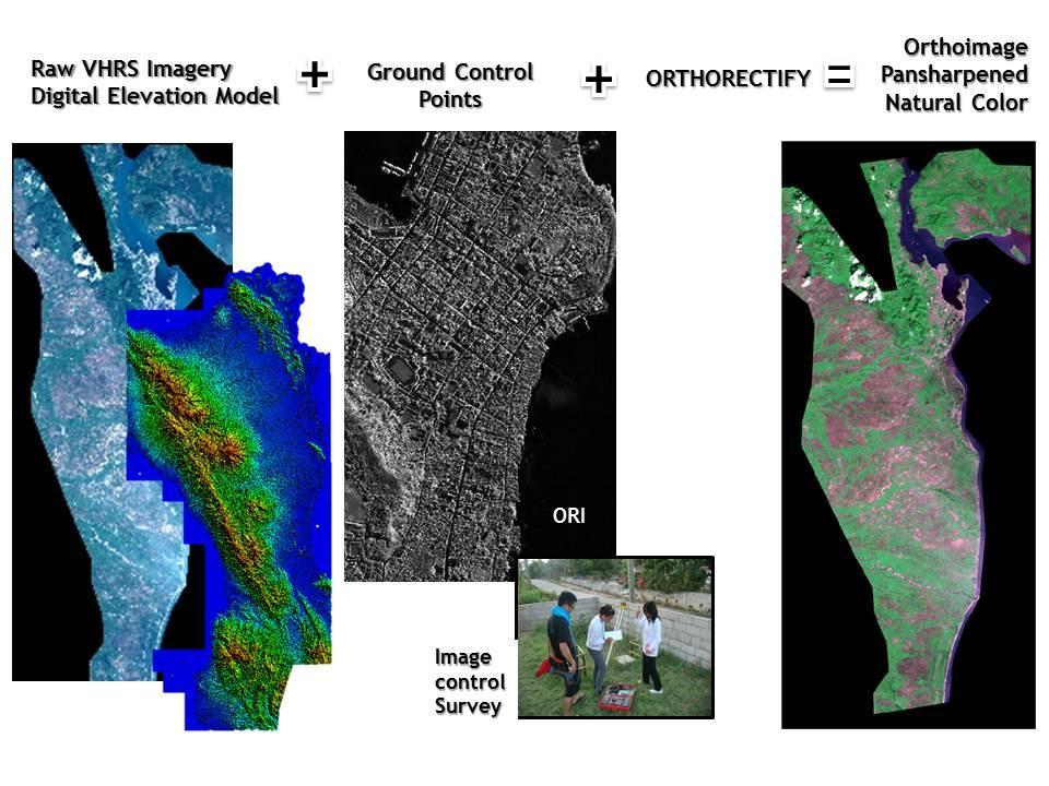
 consisting of World View-2 and")
6 In the implementation of the UMP, Very High Resolution Satellite Images (VHRSI) consisting of World View-2 and GeoEye
 would")
7 DTM derived from IfSAR For elevation data, Interferometric Synthetic Aperture Radar (IfSAR) would be utilized

 Digital Terrain")
 5.")

8 Acquired 2013 Nationwide Coverage High Resolution Digital Elevation Model Digital Surface Model (DSM) Digital Terrain Model (DTM) Orthorectified Radar Image (ORI) 5.0m Resolution DEM 0.625m Resolution ORI 1.0m RMSE Vertical Accuracy 2.0m RMSE Horizontal Accuracy
9 Priority areas for the UMP were the 18 major river basins area: 11 million hectares

10 After Yolanda, disaster-affected area became top priority for the Unified Mapping Project 11 Cities & 160 Municipalities, approx. 2,365,500 has.

11 a. Other Image Sources JICA Pleiades images from JICA covering coastlines of Leyte and Eastern Samar
12 a. Other Image Sources Department of Science and Technology (DOST)-Project NOAH Satellite tasking of Post-Yolanda Word View-2 images
")
13 b. Image Control Point (ICP) Survey
14 c. Image Processing


15 d. Feature Extraction

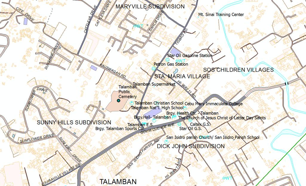
16 e. Field Verification and Validation ROAD / TRANSPORTATION Names of roads/street names, railways, railway stations Road surface classification as to: Concrete, Asphalt, Earth or Gravel WATER AND ASSOCIATED FEATURES Name of river, creek, canal, and lagoon Name of lake, other water bodies BRIDGE / TUNNEL BUILDING Name of bridges / tunnels School / University / College Barangay Hall / Health Center Church / Chapel / Mosque / Mission / Other religion Hospital Police station / military camp reservation Other government agencies Prominent Building / Establishment / Commercial / Industrial Gasoline Station Lighthouse SUBDIVISION / VILLAGE Name of subdivision / Village / Sitio / Settlement ADMINISTRATIVE AND GEOGRAPHICAL NAMES, ADMINISTRATIVE BOUNDARIES Provincial boundary / Province name City or Municipal boundary / City or Municipal name Barangay boundary (if available) / Barangay name VEGETATION Vegetation Cover, i.e. rice field, crop land / agricultural land, orchard, mangrove, broadleaf, mixed scrub & broadleaf, grass, swamp / marsh, coconut, bushes / scrub Others Cemetery / Memorial Park Pier / Jetty / Port Bus Terminal / Airport Monument name / Landmark / Park / Recreation Areas Mountain Name Agriculture Farm / Hatchery Tower / Radio / Communication / Cell Site Name

17 f. Geodatabasing Extracted Features Geodatabase Field Data Process Flow Data Conversion (from.dwg to.gdb) Quality Control (Visual and Topology Check) Data Validation (from field data)


18 f. Geodatabasing Spatial data with attributes stored in a database

19

20
21 The problem of cloud cover for optical satellite data covering tropical regions like the Philippines always persist, which is major constraining factor in the timely production of base maps for disaster risk reduction and management. For calamities of the of Yolanda magnitude, multi-lateral agencies that are conducting their own damage assessment, researches and studies in the affected state using earth observation data may consider sharing their raw data with the national geospatial information agency (NGIA) of the said state to be used as additional input in the production of base maps.


22
Philippines NSDI Foundation Data Program. Andrew Bashfield
 Philippines NSDI Foundation Data Program Andrew Bashfield 1 Overview Part 1: Building the NSDI Framework Part 2: Collecting Foundation Datasets 2 Building the NSDI Framework Background & NDSI Overview
Use of Geospatial Data: Philippine Statistics Authority 1
 Use of Geospatial Data: Philippine Statistics Authority 1 1 Presentation by Lisa Grace S. Bersales at the UNSC 2016 side event on Geospatial information and earth observations: supporting official statistics
Applying Hazard Maps to Urban Planning
 Applying Hazard Maps to Urban Planning September 10th, 2014 SAKAI Yuko Disaster Management Expert JICA Study Team for the Metro Cebu Roadmap Study on the Sustainable Urban Development 1 Contents 1. Outline
ELEVATION IS FOUNDATIONAL. A DEM that is inaccurate or of poor resolution will pass those characteristics onto other data layers
 ELEVATION IS FOUNDATIONAL A DEM that is inaccurate or of poor resolution will pass those characteristics onto other data layers THE DEM IS FOUNDATIONAL TO ALL GIS (Geospatial Information System) LAYERS
Effective Utilization of Synthetic Aperture Radar (SAR) Imagery in Rapid Damage Assessment
 Imagery in Rapid Damage Assessment") Effective Utilization of Synthetic Aperture Radar (SAR) Imagery in Rapid Damage Assessment Case Study Pakistan Floods SUPARCO M. Maisam Raza, Ahmad H. Rabbani SEQUENCE Flood Monitoring using Satellite
Effective Utilization of Synthetic Aperture Radar (SAR) Imagery in Rapid Damage Assessment Case Study Pakistan Floods SUPARCO M. Maisam Raza, Ahmad H. Rabbani SEQUENCE Flood Monitoring using Satellite
TYPHOON HAIYAN. Known as typhoon Yolanda in the Philippines. Most powerful storm to make landfall in recorded history
 TYPHOON HAIYAN Known as typhoon Yolanda in the Philippines Most powerful storm to make landfall in recorded history Worst hit provinces: Leyte and Eastern Samar with a combined population of 2.3 M Experienced
SUPPORTS SUSTAINABLE GROWTH
 DDSS BBUUN NDDLLEE G E O S P AT I A L G O V E R N A N C E P A C K A G E SUPPORTS SUSTAINABLE GROWTH www.digitalglobe.com BRISBANE, AUSTRALIA WORLDVIEW-3 30 CM International Civil Government Programs US
Manitoba s Elevation (LiDAR) & Imagery Datasets. Acquisition Plans & Opportunities for Collaboration
 & Imagery Datasets. Acquisition Plans & Opportunities for Collaboration") Manitoba s Elevation (LiDAR) & Imagery Datasets Acquisition Plans & Opportunities for Collaboration Manitoba Planning Conference May 2017 Presentation Outline Manitoba s Elevation (LiDAR) and Imagery Datasets
Manitoba s Elevation (LiDAR) & Imagery Datasets Acquisition Plans & Opportunities for Collaboration Manitoba Planning Conference May 2017 Presentation Outline Manitoba s Elevation (LiDAR) and Imagery Datasets
ESTIMATING LAND VALUE AND DISASTER RISK IN URBAN AREA IN YANGON, MYANMAR USING STEREO HIGH-RESOLUTION IMAGES AND MULTI-TEMPORAL LANDSAT IMAGES
 ESTIMATING LAND VALUE AND DISASTER RISK IN URBAN AREA IN YANGON, MYANMAR USING STEREO HIGH-RESOLUTION IMAGES AND MULTI-TEMPORAL LANDSAT IMAGES Tanakorn Sritarapipat 1 and Wataru Takeuchi 1 1 Institute
Fugro Geospatial: Turning Spatial Data into Knowledge
 Fugro Geospatial: Turning Spatial Data into Knowledge 2016 Fugro Geospatial, GIS and Consultants Locations Variety of Collection Platforms Traditional Mapping Traditional Mapping Imagery Photogrammetric
GIS and Remote Sensing
 Spring School Land use and the vulnerability of socio-ecosystems to climate change: remote sensing and modelling techniques GIS and Remote Sensing Katerina Tzavella Project Researcher PhD candidate Technology
Application of Remote Sensing and GIS in Seismic Surveys in KG Basin
 P-318 Summary Application of Remote Sensing and GIS in Seismic Surveys in KG Basin M.Murali, K.Ramakrishna, U.K.Saha, G.Sarvesam ONGC Chennai Remote Sensing provides digital images of the Earth at specific
DRRM in the Philippines: DRRM Projects, Geoportals and Socio-Economic Integration
 Regional workshop on Geo-referenced information system for improving disaster risk preparedness and management in Asia and the Pacific 26-27 June 2014, UNCC, Bangkok, Thailand DRRM in the Philippines:
DATA APPLIANCE FOR ARCGIS
 DATA APPLIANCE FOR ARCGIS Data Appliance for ArcGIS Provides Access to Multi-Scale Basemaps Down to Medium Scale Levels Worldwide And Large Scale for Most of the World The Data Appliance includes Several
Designing GIS Databases to Support Mapping and Map Production Charlie Frye, ESRI Redlands Aileen Buckley, ESRI Redlands
 Designing GIS Databases to Support Mapping and Map Production Charlie Frye, ESRI Redlands Aileen Buckley, ESRI Redlands 1 Designing GIS Databases to Support Mapping and Map Production Charlie Frye, ESRI
Improvement of Hazard Assessment and Management in the Philippines
 Improvement of Hazard Assessment and Management in the Philippines (2014 Summer Training Course for Slope Land Disaster Reduction) Ian Alejandrino (Philippines) Nguyen Manh Hieu (Vietnam) Presentation
Geography and Earth Science. Unit 5
 Geography and Earth Science Unit 5 Chapter 1 Map Skills Lesson 2 Introduction to Maps Key Terms What You Will Learn to Do Use map reading skills bar scale contrast elevation intermittent landforms legend
USGS Hydrography Overview. May 9, 2018
 + 1 USGS Hydrography Overview May 9, 2018 + 2 The National Geospatial Program Provides the geospatial baseline of the Nation s topography, natural landscape and built environment through The National Map,
Positional accuracy of the drainage networks extracted from ASTER and SRTM for the Gorongosa National Park region - Comparative analysis
 Positional accuracy of the drainage networks extracted from ASTER and SRTM for the Gorongosa National Park region - Comparative analysis Tiago CARMO 1, Cidália C. FONTE 1,2 1 Departamento de Matemática,
CENSUS MAPPING WITH GIS IN NAMIBIA. BY Mrs. Ottilie Mwazi Central Bureau of Statistics Tel: October 2007
 CENSUS MAPPING WITH GIS IN NAMIBIA BY Mrs. Ottilie Mwazi Central Bureau of Statistics E-mail: omwazi@npc.gov.na Tel: + 264 61 283 4060 October 2007 Content of Presentation HISTORICAL BACKGROUND OF CENSUS
3D BUILDING GIS DATABASE GENERATION FROM LIDAR DATA AND FREE ONLINE WEB MAPS AND ITS APPLICATION FOR FLOOD HAZARD EXPOSURE ASSESSMENT
 3D BUILDING GIS DATABASE GENERATION FROM LIDAR DATA AND FREE ONLINE WEB MAPS AND ITS APPLICATION FOR FLOOD HAZARD EXPOSURE ASSESSMENT Jojene R. Santillan, Meriam Makinano-Santillan, Linbert C. Cutamora,
Flood Modeling using Gis and LiDAR of Padada River in Southeastern Philippines
 Flood Modeling using Gis and LiDAR of Padada River in Southeastern Philippines Joseph E. Acosta 2, Ryan Keath L. De Leon 1, Judy Rose D. Hollite 1, Richard M. Logronio 1 and Genelin Ruth James 1 1 LiDAR
Government GIS and its Application for Decision Support
 Government GIS and its Application for Decision Support Zhang Qingpu (Chinese Academy of Surveying and Mapping, Email: zhangqp@casm.ac.cn) Abstract: Application of GIS in government agencies is called
GEOMATICS. Shaping our world. A company of
 GEOMATICS Shaping our world A company of OUR EXPERTISE Geomatics Geomatics plays a mayor role in hydropower, land and water resources, urban development, transport & mobility, renewable energy, and infrastructure
DAMAGE DETECTION OF THE 2008 SICHUAN, CHINA EARTHQUAKE FROM ALOS OPTICAL IMAGES
 DAMAGE DETECTION OF THE 2008 SICHUAN, CHINA EARTHQUAKE FROM ALOS OPTICAL IMAGES Wen Liu, Fumio Yamazaki Department of Urban Environment Systems, Graduate School of Engineering, Chiba University, 1-33,
CfC REFORM STORY NO. 9 PAGE 04
 CfC REFORM STORY NO. 9 PAGE 04 Footnote here CfC REFORM STORY NO. 9 PAGE 02 CfC REFORM STORY NO. 9 PAGE 03 Coalitions for Change is a centerpiece program of the partnership between the Australian Embassy
Introduction. Elevation Data Strategy. Status and Next Steps
 1 2 Introduction Elevation Data Strategy Status and Next Steps 3 Canada is the 2nd largest country in the world - 9.9 million sq km Surrounded by 3 oceans with 202 000 km of coastline Population over 35
Copernicus Overview. Major Emergency Management Conference Athlone 2017
 Copernicus Overview Major Emergency Management Conference Athlone 2017 Copernicus is a European programme implemented by the European Commission. The services address six thematic areas: land, marine,
MAPS AND THEIR CLASSIFICATION
 MAPPING MAPS AND THEIR CLASSIFICATION WHAT IS A MAP? A map is representation of the Earth's surface, showing how things are related to each other by distance, direction, and size. Maps are a way of showing
Application of high-resolution (10 m) DEM on Flood Disaster in 3D-GIS
 DEM on Flood Disaster in 3D-GIS") Risk Analysis V: Simulation and Hazard Mitigation 263 Application of high-resolution (10 m) DEM on Flood Disaster in 3D-GIS M. Mori Department of Information and Computer Science, Kinki University, Japan
Risk Analysis V: Simulation and Hazard Mitigation 263 Application of high-resolution (10 m) DEM on Flood Disaster in 3D-GIS M. Mori Department of Information and Computer Science, Kinki University, Japan
Response and Lesson Learned from Typhoon YOLANDA (HAIYAN)
") 9 th NARBO IWRM Training Tagaytay City May 12-19, 2014 Response and Lesson Learned from Typhoon YOLANDA (HAIYAN) Rene B. Paciente Weather Division, PAGASA Philippines OUTLINE 1. Meteorological Informations
9 th NARBO IWRM Training Tagaytay City May 12-19, 2014 Response and Lesson Learned from Typhoon YOLANDA (HAIYAN) Rene B. Paciente Weather Division, PAGASA Philippines OUTLINE 1. Meteorological Informations
WGIA7 9th July, Noriko KISHIMOTO
 Utilizing Global Map for addressing Climate Change WGIA7 9th July, 2009 Seoul, Republic of Korea Noriko KISHIMOTO n-kishimoto@gsi.go.jp Geographic Survey Institute, JAPAN Outline of the Global Map What
Primary Activities - natural vegetation - quarrying activities - agriculture / farming - dams
 (c) Human features We interpret human features on a topographic map in order to find out the activities that are carried out by people and how they are influenced by the physical environment and other
Framework Contract for Copernicus Service in Support to EU External Action Geospatial Production
 Framework Contract for Copernicus Service in Support to EU External Action Geospatial Production ANNEX E to the Tender Specifications SEA Portfolio Invitation to tender SATCEN-OP-01/17 Page 1 of 11 1.
Terrain Analysis through Maps.
 Terrain Analysis through Maps Need for Maps Theodolite Every Inch on Earth is Measured Maps are Prepared based on these Measurements Classification of Maps Function Scale Physical (Natural Features)
Utilization of Global Map for Societal Benefit Areas
 Utilization of Global Map for Societal Benefit Areas The Fourth GEOSS AP Symposium Bali Indonesia, 11th March 2010 Shuhei Kojima Geographical Survey Institute Ministry of Land, Infrastructure, Transport
Product description: GSD-Property Map, layered raster List of contents
 L A N T M Ä T E R I E T 1 (9) D ate: D ocument version: 2011-04-08-1.4 Product description: GSD-Property Map, layered raster List of contents 1 General description... 3 1.1 Contents... 3 1.1.1 Administrative
DRAPE 2014 Digital Elevation Model
 DRAPE 2014 Digital Elevation Model User Guide Spatial Data Infrastructure Mapping and Information Resources Branch Corporate Management and Information Division Ministry of Natural Resources and Forestry
Current Status of the Standardization of Geographical Names in Cambodia
 1 Current Status of the Standardization of Geographical Names in Cambodia His Excellency Ith Sotha, Under Secretary of States, MLMUPC Mr Chharom Chin, Deputy Director, Geography Department, MLMUPC Mr Narith
Use of Geospatial data for disaster managements
 Use of Geospatial data for disaster managements Source: http://alertsystemsgroup.com Instructor : Professor Dr. Yuji Murayama Teaching Assistant : Manjula Ranagalage What is GIS? A powerful set of tools
Georeferencing and Satellite Image Support: Lessons learned, Challenges and Opportunities
 Georeferencing and Satellite Image Support: Lessons learned, Challenges and Opportunities Shirish Ravan shirish.ravan@unoosa.org UN-SPIDER United Nations Office for Outer Space Affairs (UNOOSA) UN-SPIDER
CS 350 A Computing Perspective on GIS
 CS 350 A Computing Perspective on GIS What is GIS? Definitions A powerful set of tools for collecting, storing, retrieving at will, transforming and displaying spatial data from the real world (Burrough,
UNITED NATIONS E/CONF.96/CRP. 5
 UNITED NATIONS E/CONF.96/CRP. 5 ECONOMIC AND SOCIAL COUNCIL Eighth United Nations Regional Cartographic Conference for the Americas New York, 27 June -1 July 2005 Item 5 of the provisional agenda* COUNTRY
USING THE MILITARY LENSATIC COMPASS
 USING THE MILITARY LENSATIC COMPASS WARNING This presentation is intended as a quick summary, and not a comprehensive resource. If you want to learn Land Navigation in detail, either buy a book; or get
GEO-INFORMATICS AND SPACE TECHNOLOGY FOR PROPERTIES DIGITAL TAX MAP : CASE STUDY ON LOCAL ADMINISTRATIVE WONG KONG MUNICIPALITY, PHITSANULOK, THAILAND
 GEO-INFORMATICS AND SPACE TECHNOLOGY FOR PROPERTIES DIGITAL TAX MAP : CASE STUDY ON LOCAL ADMINISTRATIVE WONG KONG MUNICIPALITY, PHITSANULOK, THAILAND Vicharn Amarakul Regional Center of Geo-Informatics
ACCURACY ASSESSMENT OF ASTER GLOBAL DEM OVER TURKEY
 ACCURACY ASSESSMENT OF ASTER GLOBAL DEM OVER TURKEY E. Sertel a a ITU, Civil Engineering Faculty, Geomatic Engineering Department, 34469 Maslak Istanbul, Turkey sertele@itu.edu.tr Commission IV, WG IV/6
ALBANIA IN THE GLOBAL MAP. Milot LUBISHTANI, Bashkim IDRIZI
 ALBANIA IN THE GLOBAL MAP Milot LUBISHTANI, Bashkim IDRIZI Overview: Introduction GSDI Global Mapping Introduction Standards Participating Utilization Data structure Albanian Global Map Dataset Process
EXTRACTION OF FLOODED AREAS DUE THE 2015 KANTO-TOHOKU HEAVY RAINFALL IN JAPAN USING PALSAR-2 IMAGES
 EXTRACTION OF FLOODED AREAS DUE THE 2015 KANTO-TOHOKU HEAVY RAINFALL IN JAPAN USING PALSAR-2 IMAGES F. Yamazaki a, *, W. Liu a a Chiba University, Graduate School of Engineering, Chiba 263-8522, Japan
USING LIDAR MEASUREMENTS FOR IMPROVING OR UP-DATING A DEM
 JAES_1(14)_3_2011 VAIS M. et. all, pp.123-128 SECTION Geodesic Engineering USING LIDAR MEASUREMENTS FOR IMPROVING OR UP-DATING A DEM VAIS Manuel*, IOSIF Gheorghe, Bucharest University, *e-mail: manuel.vais@sipg.ro
Keywords: ASTER, SRTM, Digital Elevation Model, GPS-Levelling data, Validation.
 www.sgem.org ACCURACY ASSESSMENT OF ASTER AND SRTM DIGITAL ELEVATION MODELS: A CASE STUDY IN TURKEY H. Tugba Arli IL 1 Dr. R. Alpay ABBAK 2 1 Ministry of Health - Turkey 2 Selcuk University - Turkey ABSTRACT
Spatial Model of the First Bulgarian Capital Pliska Based on Remote Sensing and Ground- Based Data. Stefan Stamenov, Bulgaria
 Spatial Model of the First Bulgarian Capital Pliska Based on Remote Sensing and Ground- Based Data Stefan Stamenov, Bulgaria 1 Location of the study area 2 PURPOSE OF THE STUDY The purpose of this paper
EO Information Services in support of Satellite Tools for Building Flood Defence Systems in Guyana
 EO Information Services in support of Satellite Tools for Building Flood Defence Systems in Guyana F. N. Koudogbo and A. Arnaud Altamira Information J. Leen, Eurosense World Bank HQ, Washington DC Date
How to Construct Urban Three Dimensional GIS Model based on ArcView 3D Analysis
 How to Construct Urban Three Dimensional GIS Model based on ArcView 3D Analysis Ko Ko Lwin Division of Spatial Information Science Graduate School of Life and Environmental Sciences University of Tsukuba
Part : General Situation of Surveying and Mapping. The Development of Surveying and Mapping in China. The contents
 The Development of Surveying and Mapping in China Dr. Ping Xiao China.P.R The contents Part : General Situation of Surveying and Mapping 1. The legal systems of surveying and mapping 2. The technologies
5/15/ Use of Geographic Information System (GIS) in Grazing Management Muhammad Farooq Hussain Faisal 12-Arid-604 (M.
 in Grazing Management Muhammad Farooq Hussain Faisal 12-Arid-604 (M.") 5/15/218 1 Use of Geographic Information ystem (GI) in Grazing Management Muhammad Farooq Hussain Faisal 12-Arid-64 (M.phill LM) 1 Contents History Back Ground Information Introduction of GI Who use GI?
5/15/218 1 Use of Geographic Information ystem (GI) in Grazing Management Muhammad Farooq Hussain Faisal 12-Arid-64 (M.phill LM) 1 Contents History Back Ground Information Introduction of GI Who use GI?
National Cartographic Center
 National Cartographic Center NCC activities and accomplishments Activities of national organizations, institutions and universities in field of geomatics Large scale maps Medium scale maps Small scale
GEOGRAPHICAL DATABASES FOR THE USE OF RADIO NETWORK PLANNING
 GEOGRAPHICAL DATABASES FOR THE USE OF RADIO NETWORK PLANNING Tommi Turkka and Jaana Mäkelä Geodata Oy / Sanoma WSOY Corporation Konalantie 6-8 B FIN-00370 Helsinki tommi.turkka@geodata.fi jaana.makela@geodata.fi
Comparison of Intermap 5 m DTM with SRTM 1 second DEM. Jenet Austin and John Gallant. May Report to the Murray Darling Basin Authority
 Comparison of Intermap 5 m DTM with SRTM 1 second DEM Jenet Austin and John Gallant May 2010 Report to the Murray Darling Basin Authority Water for a Healthy Country Flagship Report series ISSN: 1835-095X
Overview of Philippine Geohazards Programs
 Overview of Philippine Geohazards Programs 53 rd CCOP Annual Session CCOP-IUGS Task Group on Geohazards Joint Seminar Cebu City, PHILIPPINES October 18, 2017 Renato U. Solidum, Jr. Department of Science
Geospatial Information Management in the Americas: Lessons for the Post-2015 development agenda
 Geospatial Information Management in the Americas: Lessons for the Post-2015 development agenda Rolando Ocampo President, UN-GGIM: Americas October 2014 The integration of statistical and geographical
GEOGRAPHY: PAPER II. 1. Write your examination number in the appropriate blocks provided above.
 NATIONAL SENIOR CERTIFICATE EXAMINATION NOVEMBER 2014 GEOGRAPHY: PAPER II EXAMINATION NUMBER Time: 1½ hours 100 marks PLEASE READ THE FOLLOWING INSTRUCTIONS CAREFULLY 1. Write your examination number in
FLOOD HAZARD AND RISK ASSESSMENT IN MID- EASTERN PART OF DHAKA, BANGLADESH
 FLOOD HAZARD AND RISK ASSESSMENT IN MID- EASTERN PART OF DHAKA, BANGLADESH Muhammad MASOOD MEE07180 Supervisor: Prof. Kuniyoshi TAKEUCHI ABSTRACT An inundation simulation has been done for the mid-eastern
Tracy Fuller U. S. Geological Survey. February 24, 2016
 U. S. Geological Survey Arctic Elevation Data Involvement Statewide Alaska IfSAR Radar Collection Program Pan-Arctic Digital Elevation Map International Coordination Tracy Fuller U. S. Geological Survey
CAN THO URBAN DEVELOPMENT AND RESILIENCE PROJECT
 CAN THO URBAN DEVELOPMENT AND RESILIENCE PROJECT 1 Phnom Penh Can Tho City HCM City EAST SEA 2 1 3 Highest Water Level WATER LEVEL RAISE IN CAN THO DURING LAST 40 YEARS 4 2 Land subsidence a threat that
Flood Hazard Mapping for Canada based on Spatial Data Integration and Modeling
 Flood Hazard Mapping for Canada based on Spatial Data Integration and Modeling Qiaoping Zhang 1, Michael Wollersheim 1, Natalie Findlay 1, Stephen Griffiths 1 1 Intermap Technologies Corp., Calgary, AB,
The 3D Elevation Program: Overview. Jason Stoker USGS National Geospatial Program ESRI 2015 UC
 + The 3D Elevation Program: Overview Jason Stoker USGS National Geospatial Program ESRI 2015 UC + 2 A little history USGS has a long, proud tradition of mapmaking (2009) + 3 The changing times Mapping
MAP STUDY: INTERPRETATION OF SURVEY MAPS
 MAP STUDY: INTERPRETATION OF SURVEY MAPS Types and Elements of Maps Maps are drawn to represent the Earth on a piece of paper. Maps are used widely to represent the Earth. Maps use signs and symbols in
QUESTIONNAIRE THE CURRENT STATUS OF MAPPING IN THE WORLD
 QUESTIONNAIRE ON THE CURRENT STATUS OF MAPPING IN THE WORLD The questionnaire is intended to take stock of the current status of mapping in the world. The information collected will eventually be used
GIS Generalization Dr. Zakaria Yehia Ahmed GIS Consultant Ain Shams University Tel: Mobile:
 GIS Generalization Dr. Zakaria Yehia Ahmed GIS Consultant Ain Shams University Tel: 24534976 Mobile: 01223384254 zyehia2005@yahoo.com Abstract GIS Generalization makes data less-detailed and less-complex
Spanish national plan for land observation: new collaborative production system in Europe
 ADVANCE UNEDITED VERSION UNITED NATIONS E/CONF.103/5/Add.1 Economic and Social Affairs 9 July 2013 Tenth United Nations Regional Cartographic Conference for the Americas New York, 19-23, August 2013 Item
Progress and Land-Use Characteristics of Urban Sprawl in Busan Metropolitan City using Remote sensing and GIS
 Progress and Land-Use Characteristics of Urban Sprawl in Busan Metropolitan City using Remote sensing and GIS Homyung Park, Taekyung Baek, Yongeun Shin, Hungkwan Kim ABSTRACT Satellite image is very usefully
Introduction to GIS. Dr. M.S. Ganesh Prasad
 Introduction to GIS Dr. M.S. Ganesh Prasad Department of Civil Engineering The National Institute of Engineering, MYSORE ganeshprasad.nie@gmail.com 9449153758 Geographic Information System (GIS) Information
presents challenges related to utility infrastructure planning. Many of these challenges
 1 Introduction: - a. Purpose According to U.S. Census Bureau the population of stark county was 367,585 in 1990, and in 2000 it was increase to 378,098. Thus County is experiencing a growth that presents
International Journal of Intellectual Advancements and Research in Engineering Computations
 ISSN:2348-2079 Volume-5 Issue-2 International Journal of Intellectual Advancements and Research in Engineering Computations Agricultural land investigation and change detection in Coimbatore district by
Pacific Catastrophe Risk Assessment And Financing Initiative
 Pacific Catastrophe Risk Assessment And Financing Initiative PALAU September is expected to incur, on average,.7 million USD per year in losses due to earthquakes and tropical cyclones. In the next 5 years,
(Hint: You must always back up map work questions with evidence from the map e.g. grid references.)
") Map Work Revision Notes (Hint: You must always back up map work questions with evidence from the map e.g. grid references.) Scale Scale is the ratio between a distance on a map and the corresponding distance
Map Work Revision Notes (Hint: You must always back up map work questions with evidence from the map e.g. grid references.) Scale Scale is the ratio between a distance on a map and the corresponding distance
Presented at the FIG Congress 2018, May 6-11, 2018 in Istanbul, Turkey
 Presented at the FIG Congress 2018, May 6-11, 2018 in Istanbul, Turkey GIS Application in Technical and Environmental Safety of Natural Gas Transmission Pipelines, a Case Study Tuncer OZERBIL GEOGIS GIS
GIS Geographical Information Systems. GIS Management
 GIS Geographical Information Systems GIS Management Difficulties on establishing a GIS Funding GIS Determining Project Standards Data Gathering Map Development Recruiting GIS Professionals Educating Staff
New LPIS data and their quality control in Macedonia. Pavel TROJACEK & Adam ZLOTY EKOTOXA s.r.o.
 New LPIS data and their quality control 15th GeoCAP Conference, Taormina, Italy 18 20 November 2009 Outline of the presentation Intro: About Macedonia 1. Design of LPIS 2. LPIS methodology 3. New spatial
PAGASA s Expectations of New-generation Satellites for Hazard Monitoring
 Country Report Philippines PAGASA s Expectations of New-generation Satellites for Hazard Monitoring VICENTE P. PALCON, JR. (Assistant Weather Services Chief) Weather Division- PAGASA DOST Email: vppalconjr@pagasa.dost.gov.ph
"GIS-Sofia" Ltd. geospatial data integration in SOFCAR geographic information system and providing services March 2018, Sofia
 "GIS-Sofia" Ltd. geospatial data integration in SOFCAR geographic information system and providing services Geographical Information System Sofia " Ltd....the beginning... Established in 1999, as a Sofia
Systems (GIS) - with a focus on.
 - with a focus on.") Introduction to Geographic Information Systems (GIS) - with a focus on localizing the MDGs Carmelle J. Terborgh, Ph.D. ESRI www.esri.com Flying Blind Jul 24th 2003 The Economist We Live in Two Worlds Natural
Introduction to Geographic Information Systems (GIS) - with a focus on localizing the MDGs Carmelle J. Terborgh, Ph.D. ESRI www.esri.com Flying Blind Jul 24th 2003 The Economist We Live in Two Worlds Natural
Radar Remote Sensing: Monitoring Ground Deformations and Geohazards from Space
 Radar Remote Sensing: Monitoring Ground Deformations and Geohazards from Space Xiaoli Ding Department of Land Surveying and Geo-Informatics The Hong Kong Polytechnic University A Question 100 km 100 km
NATIONAL MAPPING EFFORTS: THE PHILIPPINES
 NATIONAL MAPPING EFFORTS: THE PHILIPPINES Dr. RIJALDIA N. SANTOS DENR National Mapping and Resource Information Authority (NAMRIA) May 30, 2018 Land Cover/Land Use Changes (LC/LUC) and Its Impacts on Environment
Quick Response Report #126 Hurricane Floyd Flood Mapping Integrating Landsat 7 TM Satellite Imagery and DEM Data
 Quick Response Report #126 Hurricane Floyd Flood Mapping Integrating Landsat 7 TM Satellite Imagery and DEM Data Jeffrey D. Colby Yong Wang Karen Mulcahy Department of Geography East Carolina University
Crowdsourcing approach for large scale mapping of built-up land
 Crowdsourcing approach for large scale mapping of built-up land Kavinda Gunasekara Kavinda@ait.asia Geoinformatics Center Asian Institute of Technology, Thailand. Regional expert workshop on land accounting
General Overview and Facts about the Irobland
 Using Geoinformation Science to Reveal the Impact of the Eritrea-Ethiopia Boundary Commission s Decision on Irobland and People By Alema Tesfaye, Washington DC, USA Part I General Overview and Facts about
Roles of NGII in successful disaster management
 The Second UN-GGIM-AP Plenary Meeting Roles of NGII in successful disaster management Republic of Korea Teheran Iran 28 October 2013 Sanghoon Lee, Ph.D. NGII Outline Type of Disasters Occur in Korea Practical
USING 3D GIS TO ASSESS ENVIRONMENTAL FLOOD HAZARDS IN MINA
 King Fahd University of Petroleum & Minerals College of Environmental Design Geographical Information system USING 3D GIS TO ASSESS ENVIRONMENTAL FLOOD HAZARDS IN MINA Prepared by : Ali AL-Zahrani OUTLINE
USING GIS CARTOGRAPHIC MODELING TO ANALYSIS SPATIAL DISTRIBUTION OF LANDSLIDE SENSITIVE AREAS IN YANGMINGSHAN NATIONAL PARK, TAIWAN
 CO-145 USING GIS CARTOGRAPHIC MODELING TO ANALYSIS SPATIAL DISTRIBUTION OF LANDSLIDE SENSITIVE AREAS IN YANGMINGSHAN NATIONAL PARK, TAIWAN DING Y.C. Chinese Culture University., TAIPEI, TAIWAN, PROVINCE
DEVELOPMENT OF ARCGIS-CUSTOMIZED TOOL FOR FLOOD RISK ASSESSMENT AND REPORT GENERATION IN BUTUAN CITY
 DEVELOPMENT OF ARCGIS-CUSTOMIZED TOOL FOR FLOOD RISK ASSESSMENT AND REPORT GENERATION IN BUTUAN CITY Alexander T. Demetillo, Michelle V. Japitana, Dennis Y. Villanueva and Cherry Mae P. Tulfo CLAIMS-GIS
GIS Changing the World GIS Day November 15, 2017
 + GIS Changing the World GIS Day November 15, 2017 + Growing Up On The Farm 3 Geographic Information in DNR A 75 year history of mapping and GIS. Forest type map from 1944. State of Washington - Division
Watershed Classification with GIS as an Instrument of Conflict Management in Tropical Highlands of the Lower Mekong Basin
 Page 1 of 8 Watershed Classification with GIS as an Instrument of Conflict Management in Tropical Highlands of the Lower Mekong Basin Project Abstract The University of Giessen is actually planning a research
Appendix A Zoning Ordinance
 Appendix A Zoning Ordinance Appendix A Zoning Ordinance Sec. 94-164. Brookings Airport Zoning Ordinance. (a) Purpose and authority. (1) It is hereby found that an airport obstruction has the potential
Remote sensing data uses and supply in Vietnam. Dr. Chu Hải Tùng National Remote Sensing Department, Ministry of Natural Resource and Environment
 Remote sensing data uses and supply in Vietnam Dr. Chu Hải Tùng National Remote Sensing Department, Ministry of Natural Resource and Environment Content Uses of remote sensing data in Vietnam Roles of
RADAR Remote Sensing Application Examples
 RADAR Remote Sensing Application Examples! All-weather capability: Microwave penetrates clouds! Construction of short-interval time series through cloud cover - crop-growth cycle! Roughness - Land cover,
Lesson 2 Introduction to Maps. Key Terms
 Lesson 2 Introduction to Maps U.S. ARMY Key Terms J R O T C WHAT YOU WILL LEARN TO DO Use map reading skills bar scale contrast elevation intermittent landforms legend man-made marginal information orient
COUNTRY PRESENTATION ON MR JAYNAL ABEDIN JOINT SECRETARY ( WORKS & DEVELOPMENT ) MINISTRY OF DEFENCE
 MINISTRY OF DEFENCE") COUNTRY PRESENTATION ON By MR JAYNAL ABEDIN JOINT SECRETARY ( WORKS & DEVELOPMENT ) MINISTRY OF DEFENCE Bangladesh Geographical Location of Bangladesh Bangladesh Country at a Glance Physical Features 1,230
COUNTRY PRESENTATION ON By MR JAYNAL ABEDIN JOINT SECRETARY ( WORKS & DEVELOPMENT ) MINISTRY OF DEFENCE Bangladesh Geographical Location of Bangladesh Bangladesh Country at a Glance Physical Features 1,230
Southwestern Ontario Orthophotography Project (SWOOP) 2015 Digital Elevation Model
 2015 Digital Elevation Model") Southwestern Ontario Orthophotography Project (SWOOP) 2015 Digital Elevation Model User Guide Provincial Mapping Unit Mapping and Information Resources Branch Corporate Management and Information Division
Southwestern Ontario Orthophotography Project (SWOOP) 2015 Digital Elevation Model User Guide Provincial Mapping Unit Mapping and Information Resources Branch Corporate Management and Information Division
Basic GIS Concepts Basic Geographic Information System/Science (GIS) Training
 Training") Basic GIS Concepts Development and Implementation of a GIS based Road Maintenance Management System for Saint Lucia Basic Geographic Information System/Science (GIS) Training Javaid Iqbal GIS Expert (PhD
Basic GIS Concepts Development and Implementation of a GIS based Road Maintenance Management System for Saint Lucia Basic Geographic Information System/Science (GIS) Training Javaid Iqbal GIS Expert (PhD