Introduction to maps
|
|
|
- Cody Bradford
- 5 years ago
- Views:
Transcription


1 Introduction to maps
2 What is a map? A generalized view of an area, usually some portion of Earth s surface, as seen from above at a greatly reduced size Any geographical image of the environment A two-dimensional representation of the spatial distribution of selected phenomena
3 Why make maps? To represent a larger area than we can see To show a phenomenon or process we can t see with our eyes To present information concisely To show spatial relationships

4 Represent a larger area

5 Show what we can t see

6 Present info concisely

7 Show spatial relationships
8 How do we read maps? Maps are selective views of reality Size of the map relative to reality (scale) What s on the map (symbolization) Shape of the map (projection)
9 Map scale Ratio of the distance on the map to the distance on the ground Scale is a fraction Larger area covered means larger denominator Larger denominator means smaller fraction So a large-scale map covers a small area
10
11 Small-scale Large-scale
12 Map scale Ratio of the distance on the map to the distance on the ground 1. Graphic: Stays the same when photocopied Might not be right for the whole map
13 Map scale 1. Verbal: 1 inch equals 10 miles Easy to understand Can change if photocopied
14 Map scale 1. Representative fraction or ratio: 1:24,000 Units don t matter Can change if photocopied
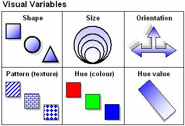
15 Map symbolization Symbols are a code instead of text Three kinds: point, line, area Consider shape, size, orientation, pattern, color, value
16
17 Point symbols Every symbol counts as one occurrence Qualitative points Indicate location Can also describe that location Quantitative points Show a distribution Indicate a value (graduated symbols)


18 Indicate location Describe location
19 Show a distribution

20 Indicate a value
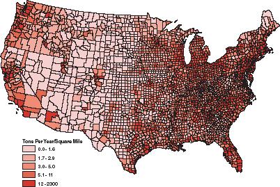
21 Line symbols One-dimensional Mostly taken for granted (borders, roads) Isolines connect same values Flow-line maps indicate value by width of line
22

23 Isolines (Contour lines)

24 Flow-line maps
25 Area symbols Each territory or region has one value Differences in kind Differences in value Choropleth maps Usually, darker indicates more Cartograms distort area to show value

26 Differences in kind

27 Differences in kind

28 Differences in value (Choropleth)

29 Cartogram
30 Topographic maps Also called quadrangles Nearly 54,000 for the U.S. Done by the US Geological Survey (USGS) since 1897 Map out the entire country in a standard fashion
31 Topographic maps Till the 1940s, you climbed to the highest point and plotted what you could see from there Aerial photography after WWII Two overlapping photos are put in a stereoscope 10 photos for each 7.5 minute map
32 Topographic maps Show 2D features, point, line and area; also show 3D via contour lines Common symbols are in the appendix of the text Note the contour interval at the bottom of the map


33
34 Typical Graph This is an example of a typical graph we are all familiar with. The graph is made up of different points with lines that connect the points.
35 Typical Graph Y axis Each point has two values: The X value that runs along the horizontal X axis The Y value that runs along the vertical Y axis X axis


36 Typical Graph Y (3,8) (9,5) (0,0) X value is always stated first Followed by the Y value The origin is the point where the 2 axes intersect with a X value of (0,0)
37 Typical Graph A point can also have negative (-) values Y Negative X values (-X,+Y) (+X,+Y) (0,0) X are to the left of the origin (0,0) Negative Y values (-X,-Y) (+X,-Y) are below the origin
38 East West, North South on The Earth Y X Let the X axis be the Equator. Let the Y axis be the Prime Meridian that runs through Greenwich outside of London. Lat/Long are the 2 grid points by which you can locate any point on earth.
39 East West, North South on the Earth N Let each of the four quarters W E then be designated by North or South S and East or West.
40 East West, North South on the Earth (N, W) (N, E) (S, W) (S, E) The N tells us we re north of the Equator. The S tells us we re south of the Equator. The E tells us that we re east of the Prime Meridian. The W tells us that we re west of the Prime Meridian.
41 East West, North South on the Earth (N, W) Prime Meridian That means all points in North America will have a North latitude and a West longitude because it is North of the Equator and West of the Prime Meridian.
42 East West, North South on the Earth What would be the latitude and longitude directions in Australia? Prime Meridian If you said South and East, you re right!
43 What is Latitude? 90 N Y 90 S X Latitude is the distance from the equator along the Y axis. All points along the equator have a value of 0 degrees latitude. North pole = 90 N South pole = 90 S Values are expressed in terms of degrees.
44 What is Latitude? 90 N Y Each degree of latitude is divided into X 60 minutes. Each minute is 90 S divided into 60 seconds. This is also true of longitude.
45 What is Latitude? 90 N Y For Example: N X This is close to the latitude where you live. 90 S
46 What is Longitude? Longitude is the distance from the prime meridian along the X axis. Y 180 W 180 E X All points along the prime meridian have a value of 0 degrees longitude. The earth is divided into two parts, or hemispheres, of east and west longitude.
47 What is Longitude? Y The earth is divided into 360 equal slices (meridians) X 180 west and 180 east of the prime meridian 180 W 180 E
48 What is Latitude? 90 N Y Our latitude and longitude might be: X N W 90 S
 is where the equator intersects the prime meridian.")
49 So Where is (0,0)? The origin point (0,0) is where the equator intersects the prime meridian. (0,0) is off the western coast of Africa in the Atlantic Ocean.
50 See If You Can Tell In Which Quarter These Lon/Lats Are Located A C B D N, 21 E N, 76 W S, 141 W 4. 7 S, 23 W N, 29 E S, 151 E

51 1. B 2. A 3. C 4. C 5. B 6. D


52
53 Positioning on the Earth s Surface East is the direction of rotation of the Earth Prime Meridian 0 o Longitude North Pole Latitude: (90 o N to 90 o S) Longitude: (180 o E to 180 o W) 22 nd Sept 20 th March Tropic of Cancer 21 st June Equator 22 nd December Tropic of Capricorn Longitude 90 o West Longitude 60 o West o 90 o W E o 66½23½ o o ½ o Latitude 23½ o North Latitude 0 o Latitude 23½ o South Longitude 90 o East Longitude 60 o East Longitude 30 o West Longitude 30 o East South Pole Latitude and Longitude together enable the fixing of position on the Earth s surface.
54 Lat/Long Video
55 The Changing Global Environment
56 Learning Objectives Develop a working knowledge of Earth s environmental systems Geology Climate Hydrology Vegetation Agriculture Set the physical context for understanding humanenvironment interactions in the world s regions Diversity Amid Globalization, 3rd edition: Rowntree, Lewis, Price & Wyckoff 56

57 02_00CO.JPG Diversity Amid Globalization, 3rd edition: Rowntree, Lewis, Price & Wyckoff 57

58
59 Key Concepts Plate Tectonics Convergent vs. Divergent Plate Boundaries Rift Valleys Geologic Hazards Insolation Greenhouse Effect Climate Regions Climographs Global Warming Water Stress Biome Desertification Subsistence Agriculture Green Revolution Diversity Amid Globalization, 3rd edition: Rowntree, Lewis, Price & Wyckoff 59
60 Earth s Environmental Systems Geology Climate Water Hydrology Vegetation Agriculture Bio Food Resources Earth Air Diversity Amid Globalization, 3rd edition: Rowntree, Lewis, Price & Wyckoff 60
61 Geological Environment Connections between inner earth and surface landscape features. Part of the framework for understanding human settlement patterns. Diversity Amid Globalization, 3rd edition: Rowntree, Lewis, Price & Wyckoff 61
62 Plate Tectonics Slow moving geologic plates Figure 2.3 Heat exchange: Convection cells Diversity Amid Globalization, 3rd edition: Rowntree, Lewis, Price & Wyckoff 62

63 Diversity Amid Globalization, 3rd edition: Rowntree, Lewis, Price & Wyckoff 63

64 Global Tectonic Plates Diversity Amid Globalization, 3rd edition: Rowntree, Lewis, Price & Wyckoff 64

65 02_04.JPG Diversity Amid Globalization, 3rd edition: Rowntree, Lewis, Price & Wyckoff 65

66 02_05.JPG Diversity Amid Globalization, 3rd edition: Rowntree, Lewis, Price & Wyckoff 66

67 02_06.JPG Diversity Amid Globalization, 3rd edition: Rowntree, Lewis, Price & Wyckoff 67

68 Diversity Amid Globalization, 3rd edition: Rowntree, Lewis, Price & Wyckoff 68

69 02_07.JPG Diversity Amid Globalization, 3rd edition: Rowntree, Lewis, Price & Wyckoff 69

70 02_08.JPG Diversity Amid Globalization, 3rd edition: Rowntree, Lewis, Price & Wyckoff 70

71 Diversity Amid Globalization, 3rd edition: Rowntree, Lewis, Price & Wyckoff 71
72 Global Tectonics
73 Global Climates Solar Energy Latitude Land/Water Interaction Global Pressure Systems Global Wind Patterns Climatic Controls Diversity Amid Globalization, 3rd edition: Rowntree, Lewis, Price & Wyckoff 73

74 02_09.JPG Insolation and the Greenhouse Effect Diversity Amid Globalization, 3rd edition: Rowntree, Lewis, Price & Wyckoff 74

75 Diversity Amid Globalization, 3rd edition: Rowntree, Lewis, Price & Wyckoff 75
76 Atmospheric Energy Balance

77 Influence of Latitude Diversity Amid Globalization, 3rd edition: Rowntree, Lewis, Price & Wyckoff 77

78 Global Pressure Systems and Wind Patterns Diversity Amid Globalization, 3rd edition: Rowntree, Lewis, Price & Wyckoff Figure
79 Global Wind Patterns

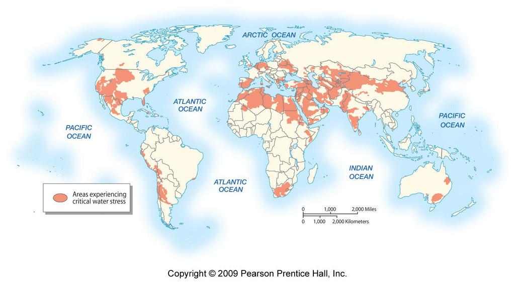
80 Global Pressure Systems and Wind Patterns 02_11.JPG Diversity Amid Globalization, 3rd edition: Rowntree, Lewis, Price & Wyckoff 80

81 02_12.JPG Diversity Amid Globalization, 3rd edition: Rowntree, Lewis, Price & Wyckoff 81
82 Diversity Amid Globalization, 3rd edition: Rowntree, Lewis, Price & Wyckoff 82
83 Global Warming Anthropogenic Causes: Human-induced Major Greenhouse Gases Carbon dioxide Chlorofluorocarbons Methane Nitrogen oxides Effects Shifts in agricultural areas Rising sea levels Diversity Amid Globalization, 3rd edition: Rowntree, Lewis, Price & Wyckoff 83

84
85 Global Warming

86 02_16.JPG Diversity Amid Globalization, 3rd edition: Rowntree, Lewis, Price & Wyckoff 86

87 Bangladesh Brick Factory Globalization and Global Warming: Tensions between developed and less developed countries Diversity Amid Globalization, 3rd edition: Rowntree, Lewis, Price & Wyckoff 87 Figure 2.15
88 Water Resources If total global water supply was 100 liters (26 gallons), then: 3 liters (0.8 gallons) = fresh water liters (~1/2 teaspoon) would be available to humans Water Stress: greatest water resource problems Diversity Amid Globalization, 3rd edition: Rowntree, Lewis, Price & Wyckoff 88
89

90 Water Resources and Stress Too Little Too Much Figure 2.16 Figure 2.17 Diversity Amid Globalization, 3rd edition: Rowntree, Lewis, Price & Wyckoff 90

91 02_18.JPG Diversity Amid Globalization, 3rd edition: Rowntree, Lewis, Price & Wyckoff 91

92 Biomes


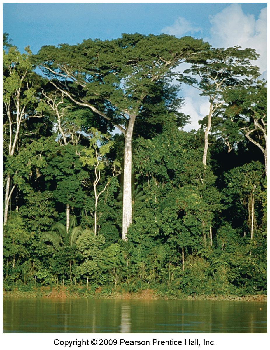
93 Examples of Biomes - Forests Figure 2.19 Tropical Rainforest Figure 2.21 Temperate Forest Diversity Amid Globalization, 3rd edition: Rowntree, Lewis, Price & Wyckoff 93
94

95


96 Agriculture Figure 2.23 Subsistence Agriculture Figure 2.22 Industrialized Agriculture Diversity Amid Globalization, 3rd edition: Rowntree, Lewis, Price & Wyckoff 96
97 02_23.JPG Diversity Amid Globalization, 3rd edition: Rowntree, Lewis, Price & Wyckoff 97

98 02_24.JPG Diversity Amid Globalization, 3rd edition: Rowntree, Lewis, Price & Wyckoff 98
99 Green Revolution Since 1950s: Increases in food production primarily from expansion of intensive, industrial agriculture into more traditionally farmed areas. Diversity Amid Globalization, 3rd edition: Rowntree, Lewis, Price & Wyckoff 99
100 Two Stages of the Green Revolution 1 st Stage: 3 processes Traditional mixed crops monocrops or high yield, genetically modified seeds Increase intensity Water, fertilizer and pesticides Reduce fallow time between seasonal crops 2 nd Stage: Since 1970s New crops bred for tropical and subtropical climates Multiple crops in one parcel Diversity Amid Globalization, 3rd edition: Rowntree, Lewis, Price & Wyckoff 100

101 02_25.JPG Diversity Amid Globalization, 3rd edition: Rowntree, Lewis, Price & Wyckoff 101

102 Increased Food Production High Costs Environmental Fossil Fuel Use Habitat Fragmentation/ Damage Pollution: Water and Air Social Financial Costs Social Inequalities Figure 2.20 What cost does this photograph represent? Diversity Amid Globalization, 3rd edition: Rowntree, Lewis, Price & Wyckoff 102

103 Globalization and Food Production Food Supply Local and regional issues Distribution and purchasing power Political Influences Food shortages and Famine Changing Dietary Preferences Two Regions of Concern Africa South Asia Figure 2.24 Diversity Amid Globalization, 3rd edition: Rowntree, Lewis, Price & Wyckoff 103
104 02_26.JPG Diversity Amid Globalization, 3rd edition: Rowntree, Lewis, Price & Wyckoff 104
Latitude. Longitude. Cartography. -Latus wide. -Longus length. Greek Carto meaning "map Graphein meaning "write the study and practice of making maps
 Cartography Greek Carto meaning "map Graphein meaning "write the study and practice of making maps Lines of longitude only Equator added Cross-section through line of longitude Other lines of latitude
Geography Route Planner
 Geography Route Planner Introduction to Route Planners Route Planners outline the Key Stages 1-3 curriculum to be taught within each campus of the Bury St Edmunds Trust. Each Route Planner has been designed
Map Skills Unit. Note taking unit
 Map Skills Unit Note taking unit Introduction To learn about the Earth, we are going to learn about two geographic tools you can use.globes and maps. Globe A globe is a round model of the planet Earth
Tuition, Medical and Behaviour Support Service
 Tuition, Medical and Behaviour Support Service Curriculum Policy - Primary Geography Reviewed: October 2018 Next Review: October 2019 Responsibility: Andrea Snow AIMS AND PRINCIPLES The national curriculum
New National Curriculum Geography Skills Planning KS1
 New National Curriculum Geography Skills Planning KS1 Enquiry Question Objective-essential knowledge skills or understanding Locational Knowledge Standards /Success Criteria Lesson progression over half
Geography Progression
 Geography Progression This document aims to track expectations for History within George Grenville Academy. What the National Curriculum says: KS1: Locational Knowledge: Name and locate the world s 7 continents
Geography Mile Post 1
 Mile Post 1 Use world maps, atlases and globes to identify the UK and its countries, as well as the countries, continents and oceans studied at this key stage Key Skills IPC learning Goals 1.11 Be able
Geography. Programmes of study for Key Stages 1-3
 Geography Programmes of study for Key Stages 1-3 February 2013 Contents Purpose of study 3 Aims 3 Attainment targets 3 Subject content 4 Key Stage 1 4 Key Stage 2 5 Key Stage 3 6 2 Purpose of study A high-quality
Range of Opportunities
 Geograhy Curriculum Cropwell Bishop Primary School Range of Opportunities Year 1 Year 2 Year 3 Year 4 Year 5 Year 6 All Key Stage 1 Key Stage 2 Investigate the countries and capitals of the United Kingdom.
Complete Geography Overview: Year 1 to Year 6
 Option 1 Complete Geography Overview: Year 1 to Year 6 Autumn Term Spring Term Summer Term Year 1 Where do I live? Around the World The Four Seasons Year 2 At the Farm Let s go on Safari My World and Me
Year 1 name and locate the four countries and capital cities of the United Kingdom and its surrounding seas
 Long Term Objective Organisation for Geography Please note that only statutory requirements should be included in this document; any supplementary guidance and information should be retained by Subject
Witchampton CofE First School Geography Curriculum Map
 2016-2017 Autumn People and : 30-50 Show interest in the lives of people who are familiar to them. Shows interest in different occupations. Remembers and talks significant events in their own experience.
Test Bank Chapter 2: Representations of Earth
 Multiple Choice Test Bank Chapter 2: Representations of Earth 1. A rhumb line on a Mercator projection is a line of. a. true size b. true shape c. true compass bearing d. true location 2. Maximum longitude
Map Skills Lesson 1. Materials: maps, pencils, Lesson 1 Worksheet, strips of paper, grid paper
 Map Skills Lesson 1 Use cardinal directions, map grids, scales, and titles to locate places on a map. Interpret a map using information from its title, compass rose, scale, and legend. Vocabulary: map,
Introduction to Geography
 Introduction to Geography ropic of Cancer 3½ N Arctic Circle 90 N Prime Meridian 0 Arctic Ocean Mississippi R. Appalachian Mts. Europe Rocky Mountains N. America Atlantic Gulf of Ocean Mexico Caribbean
FIND PLACES ON GLOBES USING LATITUDE
 GLOBES, MAPS & GRAPHS FIND PLACES ON GLOBES USING LATITUDE AND LONGITUDE LINES FIND PLACES ON MAPS USING A GRID SYSTEM NAME SEVERAL TYPES OF MAP PROJECTIONS AND EXPLAIN THEIR BENEFITS AND SHORTCOMINGS
Module 2: Mapping Topic 2 Content: Determining Latitude and Longitude Notes
 Introduction In order to more easily locate points on a globe or map, cartographers designed a system of imaginary vertical lines (also called parallels) and horizontal lines (also called meridians) that
Downloaded from
 I II III IV V VI Define the following terms:- a) Orbitb) Meteoroids c) Celestial bodies GEOGRAPHY ASSIGNMENTS The Earth In The Solar System d) Satellite e) Comets Give one word answers:- a) Blue planet
Geography Long Term Plan 2018
 Geography Long Term Plan 2018 Geography Co-ordinator: Megan Frost A high-quality geography education should inspire in pupils a curiosity and fascination about the world and its people that will remain
The World of Geography Pre-Test/Study Guide Chapter 1 Test
 Read each statement or question. On the lines below write the letter of the best answer. 1. Geographers look at the Earth 5. What are the two specific A. by studying cities first. measurements of Earth
Topographic Maps and Landforms Geology Lab
 Topographic Maps and Landforms Geology Lab Ray Rector: Instructor Today s Lab Activities 1) Discussion of Last Week s Lab 2) Lecture on Topo Maps and Elevation Contours 3) Construct Topographic Maps and
AP Human Geography Chapter 1: Thinking Geographically Key Issue 1: How do Geographers describe where things are?
 AP Human Geography Chapter 1: Thinking Geographically Key Issue 1: How do Geographers describe where things are? Studying Human Geography Physical Geography Physical geography deals with Earth s natural
name and locate the world s seven continents and five oceans
 Subject: Geography Activities National Curriculum Objectives One Progression of Skills Name the 7 continents and 5 oceans 3D Jigsaw task to locate continents and seas name and locate the world s seven
Understanding Projections
 GEOGRAPHY SKILLS 1 Understanding Projections The earth is a sphere and is best shown as a globe. For books and posters, though, the earth has to be represented as a flat object. To do this, mapmakers create
Word Cards. 2 map. 1 geographic representation. a description or portrayal of the Earth or parts of the Earth. a visual representation of an area
 Name: Date: Hour: Word Cards 1 geographic representation a description or portrayal of the Earth or parts of the Earth Example: A map is a representation of an actual location or place. 2 map a visual
THE EARTH AND ITS REPRESENTATION
 UNIT 7 THE EARTH AND ITS REPRESENTATION TABLE OF CONTENTS 1 THE EARTH AND THE SOLAR SYSTEM... 2 2 THE EARTH S MOVEMENTS... 2 2.1 Rotation.... 2 2.2 The revolution of the Earth: seasons of the year....
Some of these parallels are very important. In the Northern Hemisphere, there is the Tropic of Cancer and the Arctic Circle.
 PDF 2 Geographic coordinates 1 The geographic coordinates system is network of imaginary horizontal and vertical lines that are drawn on globes or maps. These lines are called parallels (lines of latitude)
What is a map? A Map is a two or three-dimensional model or representation of the Earth s surface. 2-Dimensional map
 What is a map? A Map is a two or three-dimensional model or representation of the Earth s surface. 2-Dimensional map What is a Map Projection? Planar Projection Projection A Projection is a mathematical
World Geography Chapter 3
 World Geography Chapter 3 Section 1 A. Introduction a. Weather b. Climate c. Both weather and climate are influenced by i. direct sunlight. ii. iii. iv. the features of the earth s surface. B. The Greenhouse
Geography Long Term Plan
 Geography Long Term Plan Year Group Children should be taught about: The topic this will be based on: Essential Learning Objectives: (Taken from Chris Quigley) Year 1 Name and locate the world s seven
MEADOWS PRIMARY SCHOOL and NURSERY GEOGRAPHY POLICY
 MEADOWS PRIMARY SCHOOL and NURSERY GEOGRAPHY POLICY Purpose of study The teaching of Geography at Meadows is done by following the 2014 National Curriculum. The planning and teaching of the subject aims
Geography Long Term Plan. Autumn Spring Summer
 Geography Long Term Plan Autumn Spring Summer Year 1 Working Scientifically covered throughout the year Location Geography of UK Name, locate and identify characteristics of the four countries and capital
Pool Canvas. Add. Creation Settings. Chapter 1--Objectives and Tools of World Regional Geography. Description Instructions.
 1 of 6 TEST BANK > CONTROL PANEL > POOL MANAGER > POOL CANVAS Pool Canvas Add, modify, and remove questions. Select a question type from the Add Question drop-down list and click Go to add questions. Use
Climate Change and Biomes
 Climate Change and Biomes Key Concepts: Greenhouse Gas WHAT YOU WILL LEARN Biome Climate zone Greenhouse gases 1. You will learn the difference between weather and climate. 2. You will analyze how climate
Chapter. Introduction to Earth Science
 EARTH SCIENCE Chapter 1 Introduction to Earth Science 1.1 What Is Earth Science? Overview of Earth Science Encompasses all sciences that seek to understand Earth Earth's neighbors in space 1.1 What Is
Chapter 02 Maps. Multiple Choice Questions
 Chapter 02 Maps Multiple Choice Questions 1. Every projection has some degree of distortion because A. a curved surface cannot be represented on a flat surface without distortion. B. parallels and meridians
L.O: EARTH'S 23.5 DEGREE TILT ON ITS AXIS GIVES EARTH ITS SEASONS March 21 (SPRING), June 21(SUMMER), Sept 22 (AUTUMN) & Dec 21(WINTER)
, June 21(SUMMER), Sept 22 (AUTUMN) & Dec 21(WINTER)") L.O: EARTH'S 23.5 DEGREE TILT ON ITS AXIS GIVES EARTH ITS SEASONS March 21 (SPRING), June 21(SUMMER), Sept 22 (AUTUMN) & Dec 21(WINTER) 1. The apparent daily path of the Sun changes with the seasons because
L.O: EARTH'S 23.5 DEGREE TILT ON ITS AXIS GIVES EARTH ITS SEASONS March 21 (SPRING), June 21(SUMMER), Sept 22 (AUTUMN) & Dec 21(WINTER) 1. The apparent daily path of the Sun changes with the seasons because
NEWHAM BRIDGE PRIMARY SCHOOL FOUNDATION SUBJECTS CURRICULUM AND ASSESSMENT DOCUMENT GEOGRAPHY
 NEWHAM BRIDGE PRIMARY SCHOOL FOUNDATION SUBJECTS CURRICULUM AND ASSESSMENT DOCUMENT GEOGRAPHY Y1 Geography Curriculum Y1 Geography A.R.E Locational language: hills, beach, forest, town, country, address,
GEOGRAPHY POLICY STATEMENT. The study of geography helps our pupils to make sense of the world around them.
 GEOGRAPHY POLICY STATEMENT We believe that the study of geography is concerned with people, place, space and the environment and explores the relationships between the earth and its peoples. The study
Chapter 1 Introduction to the Earth
 Chapter 1 Introduction to the Earth What is Geography? The study of the earth as the home of humankind. Greek - Eratosthenes Father of Geography Geo means Earth Graphy means to write Study how things are
A Living Planet. The Earth Inside and Out
 A Living Planet The Earth Inside and Out Planet Earth Earth s Rotation, Revolution, and Tilt Most of Earth s energy comes from the Sun, which we call solar energy. Imagine that the Earth has an imaginary
What Is a Globe? Hemispheres. Main Idea Globes and maps provide different ways of showing features of the earth. Terms to Know
 r Main Idea Globes and maps provide different ways of showing features of the earth. Terms to Know hemisphere latitude longitude scale bar scale relief elevation contour line What Is a Globe? A globe is
The Geography Curriculum at Coston Primary
 The Geography Curriculum at Coston Primary Years Year 1 Year 2 Summer We are learning about where food is farmed and in The physical features of farms. The human features of farms. The characteristics
Complete the following: a. Lines of latitude are parallel to the equator. Name:
 Name: Date: Social Studies Introduction: Basic Geography Period: Latitude Latitude is defined as a measurement of distance in degrees north and south of the equator. The word latitude is derived from the
St Joseph s R.C. Primary School. Policy for Geography
 St Joseph s R.C. Primary School Policy for Geography 2016-2017 This policy is written with consideration to our school commitment to the Rights of the Child and our achievement of becoming a Rights Respecting
NATIONAL CURRICULUM GEOGRAPHY PLANNING OVERVIEW
 GEOGRAPHY AUTUMN TERM SPRING TERM SUMMER TERM Year 1 Hunting and Hiding Me and My Wonderful World Beside The Sea identify seasonal and daily weather patterns in the United Kingdom and the location of hot
Weather Atmospheric condition in one place during a limited period of time Climate Weather patterns that an area typically experiences over a long
 Weather Atmospheric condition in one place during a limited period of time Climate Weather patterns that an area typically experiences over a long period of time Many factors influence weather & climate
Unit 1: Basics of Geography Test Review
 Name Date Period Unit 1: Basics of Geography Test Review Directions: Reading the following sections and complete the questions, charts, and diagrams. Types of Maps Maps that have a particular theme are
Subject Progression Map
 Subject Progression Map On website Subject Name: Geography Vision-Taken from the National Curriculum A high-quality geography education should inspire in pupils a curiosity and fascination about the world
BLACK PEAR TRUST SUBJECT PLAN - GEOGRAPHY
 Purpose of Study A high-quality geography education should inspire in pupils a curiosity and fascination about the world and its people that will remain with them for the rest of their lives. Teaching
Geography Policy 2014
 Geography Policy 2014 DEFINITION Geography education should inspire in pupils a curiosity and fascination about the world and its people that will remain with them for the rest of their lives. Teaching
Chapter 3 Packet. and causes seasons Earth tilted at 23.5 / 365 1/4 days = one year or revolution
 Name Chapter 3 Packet Sequence Section 1 Seasons and Weather : and causes seasons Earth tilted at 23.5 / 365 1/4 days = one year or revolution solstice - begins summer in N. hemisphere, longest day winter
Dawood Public School Secondary Section Class VII
 Dawood Public School Secondary Section Class VII Introduction: Geography is the study of the Earth and its lands, features, inhabitants, and phenomena relating to the sciences of aforementioned. This subject
GEOGRAPHY CURRICULUM OVERVIEW
 GEOGRAPHY CURRICULUM OVERVIEW Geographical knowledge Progression Statement Autumn Spring Summer Year 1 UK and Local Area: Physical Themes: Name, locate and identify characteristics of the 4 countries and
Which graph best shows the relationship between intensity of insolation and position on the Earth's surface? A) B) C) D)
 B) C) D)") 1. The hottest climates on Earth are located near the Equator because this region A) is usually closest to the Sun B) reflects the greatest amount of insolation C) receives the most hours of daylight D)
1. The hottest climates on Earth are located near the Equator because this region A) is usually closest to the Sun B) reflects the greatest amount of insolation C) receives the most hours of daylight D)
ST AMBROSE CATHOLIC PRIMARY SCHOOL Geography Policy
 ST AMBROSE CATHOLIC PRIMARY SCHOOL Geography Policy 2017-2018 Our school policy is developed in accordance with the National Curriculum for Geography and Foundation Stage Curriculum for Understanding of
5 Themes of Geography Review Video Notes What is Geography?
 Name PG # 5 Themes of Geography Review Video Notes What is Geography? The study of, their, and their Main Idea or Topic Continents Notes about Main Idea or Topic There are 7 Continents or in the world:
5. In which diagram is the observer experiencing the greatest intensity of insolation? A) B)
 B)") 1. Which factor has the greatest influence on the number of daylight hours that a particular Earth surface location receives? A) longitude B) latitude C) diameter of Earth D) distance from the Sun 2. In
1. Which factor has the greatest influence on the number of daylight hours that a particular Earth surface location receives? A) longitude B) latitude C) diameter of Earth D) distance from the Sun 2. In
Chapter 1 Section 2. Land, Water, and Climate
 Chapter 1 Section 2 Land, Water, and Climate Vocabulary 1. Landforms- natural features of the Earth s land surface 2. Elevation- height above sea level 3. Relief- changes in height 4. Core- most inner
COURSE OUTLINE. GEO 101 Geography 3 Course Number Course Title Credits. Reference Liberal Arts Division Book List
 MERCER COUNTY COMMUNITY COLLEGE LIBERAL ARTS DIVISION COURSE OUTLINE GEO 101 Geography 3 Course Number Course Title Credits Required Materials: Catalog Description: Reference Liberal Arts Division Book
1 What Is Climate? TAKE A LOOK 2. Explain Why do areas near the equator tend to have high temperatures?
 CHAPTER 17 1 What Is Climate? SECTION Climate BEFORE YOU READ After you read this section, you should be able to answer these questions: What is climate? What factors affect climate? How do climates differ
UNIT 1 THE BASICS OF GEOGRAPHY
 UNIT 1 THE BASICS OF GEOGRAPHY CHAPTER 1 LOOKING AT THE EARTH 1 Section 1.1: The 5 Themes of Geography.Geography comes from a Greek word meaning writing about or describing the earth. Geography is: Geographers
Prentice Hall. World Explorer: People, Places, Cultures Grade 7. Oklahoma Priority Academic Student Skills (PASS) for Grade 7 World Geography
 for Grade 7 World Geography") Prentice Hall World Explorer: People, Places, Cultures 2007 Grade 7 C O R R E L A T E D T O for Grade 7 1. Locate, gather, analyze, and apply information from primary and secondary sources. WORLD GEOGRAPHY
Prentice Hall World Explorer: People, Places, Cultures 2007 Grade 7 C O R R E L A T E D T O for Grade 7 1. Locate, gather, analyze, and apply information from primary and secondary sources. WORLD GEOGRAPHY
World Geography. Teacher s Guide
 World Geography Teacher s Guide WALCH PUBLISHING Table of Contents To the Teacher.......................................................... vi Classroom Management.................................................
Exploring Geography. Chapter 1
 Exploring Geography Chapter 1 The Study of Geography Geography is the study of where people, places, and things are located and how they relate to each other. Greek meaning writing about or describing
Map Skills Test. 1. What do we call a person who makes maps? a. mapographer b. cartographer c. geologist d. archaeologist
 Map Skills Test 1. What do we call a person who makes maps? a. mapographer b. cartographer c. geologist d. archaeologist 2. What is the name of the 0 latitude line? a. Equator b. Arctic Circle c. First
... Europe. Based on Bloom s Taxonomy. Environment Interactions Movement. Human & Location. Regions. Place
 ... Europe Location Place Human & Environment Interactions Movement Regions LEVEL 1 Knowledge Match Show or Label List Information Recall Details (5Ws + H) Find Information LEVEL 2 Comprehension Describe
Name Class Date. For each pair of terms, explain how the meanings of the terms differ.
 Skills Worksheet Chapter Review USING KEY TERMS For each pair of terms, explain how the meanings of the terms differ. 1. biome and tropical zone 2. weather and climate 3. temperate zone and polar zone
Laboratory Exercise #2 Introduction to Quadrangle Maps
 page - Laboratory Exercise #2 Introduction to Quadrangle Maps A. Introduction to Quadrangle Maps The United States Geological Survey has developed a nationwide series of quadrangle maps that cover small
Geographic Grid. Locations Feature 1 Feature 2 Feature 3
 Geographic Grid Name The geographic grid refers to the internationally-recognized system of latitude and longitude used to location positions on Earth's surface. Accurate use of this coordinate system
The City School /PAF Chapter / Prep + Senior I Section / Worksheet for Intervention Class (1 st Term)/Geography /Class 6 Page 2 of 22
/Geography /Class 6 Page 2 of 22") The City School PAF Chapter Prep Section GEOGRAPHY Year 6 Worksheets for Intervention Classes The City School /PAF Chapter / Prep + Senior I Section / Worksheet for Intervention Class (1 st Term)/Geography
The City School PAF Chapter Prep Section GEOGRAPHY Year 6 Worksheets for Intervention Classes The City School /PAF Chapter / Prep + Senior I Section / Worksheet for Intervention Class (1 st Term)/Geography
Dr. M.K.K. Arya Model School Class-V, Social Science Assignment Ch-1, Globe The Model of the Earth Answer the following:- Q.1.
 Class-V, Social Science Assignment Ch-1, Globe The Model of the Earth - Q.1. What are the disadvantages/demerits of a globe? Ans. Some disadvantages of globe are: a) It is difficult to carry. b) It cannot
12. The diagram below shows the collision of an oceanic plate and a continental plate.
 Review 1. Base your answer to the following question on the cross section below, which shows the boundary between two lithospheric plates. Point X is a location in the continental lithosphere. The depth
Geography Skills Progression. Eden Park Primary School Academy
 Geography Skills Progression Eden Park Primary School Academy In order to ensure broad and balanced coverage, we follow these principles: Within each phase, geography is a driver for at least 3 Learning
8 th Grade Science Content Strand 4
 8 th Grade Science Content Strand 4 Lithosphere solid, rigid, rocky divided into plates, sits on top of asthenosphere Includes crust & upper rocky mantle Asthenosphere plastic, flowing, hot, convection
KIPP: Inspire Academy Social Studies Benchmark 1 PART I. Use the map of Missouri to answer questions 7-9.
 PART I 1) A physical map key shows: A. Climate B. Cities and borders C. Elevation and water depth D. Geographic features Use the map of Missouri to answer questions 7-9. 2) Lines of latitude: A. Are parallel
Geography Skills Progression Key Stage 2
 Year 3 Year 4 Year 5 Year 6 Expectations at end of key stage Location knowledge the countries of Europe? countries in Europe, environmental regions? countries in Europe, key physical and human characteristics?
Nursery. Reception. Year 1
 Nursery Geography Overview Autumn Spring Summer Notices detailed features of objects in their environment. Comments and asks questions about aspects of their familiar world such as the place where they
Maps. 3. Which altitude of Polaris could be observed in New York State?
 Name: Date: 1. For an observer in New York State, the altitude of Polaris is 43 above the northern horizon. This observer s latitude is closest to the latitude of A. New York City B. Utica 3. Which altitude
Holy Trinity 3-16 School. Geography Overview (Primary)
") Holy Trinity 3-16 School Key Stage 1 Geography Overview (Primary) Year Autumn 1 Autumn 2 Spring1 Spring 2 Summer 1 Summer 2 Y1 Dear Zoo Castles Gadgets and Gizmos (UK) Name, locate and identify characteristics
Holy Trinity 3-16 School Key Stage 1 Geography Overview (Primary) Year Autumn 1 Autumn 2 Spring1 Spring 2 Summer 1 Summer 2 Y1 Dear Zoo Castles Gadgets and Gizmos (UK) Name, locate and identify characteristics
Pacemaker World Geography and Cultures. correlated to. Louisiana Social Studies Grade Level Expectations: World Geography Geography Grades 9-12
 Pacemaker World and Cultures correlated to Louisiana Social Studies Grade Level Expectations: World Grades 9-12 Pacemaker World and Cultures Pearson Learning Group correlated to Louisiana Social Studies
Unit 1 All. Study online at quizlet.com/_3l51hr
 Unit 1 All Study online at quizlet.com/_3l51hr 1. geography: 4. 7 APHG Units+: The study of the distribution and interaction of physical and human features on the earth 2. physical geography: 1. Geography:
What is Geography? Lecture 1 The Earth As A Rotating Planet. What is Geography? What is geography? Subfields of Geography?
 Lecture 1 The Earth As A Rotating Planet Geog210 Physical Geography What is Geography? Much more than place names and locations The study of spatial variation How and why things differ from place to place
locate the world s countries, using maps to focus on Europe (including the location of
 Year 3 and 4 Geography study- Autumn 2 2017 National curriculum: Locational knowledge locate the world s countries, using maps to focus on Europe (including the location of Russia) and North and South
Using Map and Compass Together
 Using Map and Compass Together In situations where you foresee a potential evacuation on foot, where there are no roads, and no indication as to the direction of travel (i.e., road signs), it is recommended
Abbotswood Junior School National Curriculum 2014
 Geography Purpose A high-quality geography education should inspire in pupils a curiosity and fascination about the world and its people that will remain with them for the rest of their lives. Teaching
Cardinal and Intermediate Directions:
 Name Period Parent Signature Due Date: (TBA) Geography/Map Skills Study Guide Continents and Oceans of the World: Label the continents (7) and oceans (4) on the lines below the map. 1 11 3 5 4 8 2 9 10
KS1. Geography Progression of Knowledge, Understanding and Skills WIJPS
 Geography Progression of Knowledge, Understanding and Skills WIJPS Geography inspires pupils to delve deeper and with more curiosity and fascination into the world around them and its people. The knowledge
Mapping Earth. How are Earth s surface features measured and modeled?
 Name Mapping Earth How are Earth s surface features measured and modeled? Before You Read Before you read the chapter, think about what you know about maps Record your thoughts in the first column Pair
The Atmosphere and Atmospheric Energy Chapter 3 and 4
 The Atmosphere and Atmospheric Energy Chapter 3 and 4 Size of the Earth s Atmosphere Atmosphere produced over 4.6 billion years of development Protects us from radiation Completely surrounds the earth
Weather Atmospheric condition in one place during a limited period of time Climate Weather patterns that an area typically experiences over a long
 Weather Atmospheric condition in one place during a limited period of time Climate Weather patterns that an area typically experiences over a long period of time Many factors influence weather & climate
Chapter 2 Earth s Interlocking Systems pg The Earth and Its Forces pg
 Chapter 2 Earth s Interlocking Systems pg. 24 55 2 1 The Earth and Its Forces pg. 27 33 Connecting to Your World and Internal Forces Shaping the Earth The Earth is unique in the solar system because it
Knowledge and understanding Geographical skills. Sample pages. features people processes world places events environments characteristics
 1.1 What is geography? Knowledge and understanding Geographical skills verbal linguistic visual spatial 1 Give two reasons why it is important to study geography. 2 Use words from the box below to complete
Globes, Maps, and Atlases. Plus, A Whole Bunch of Other Way Cool Geographic Information!!!
 Globes, Maps, and Atlases Plus, A Whole Bunch of Other Way Cool Geographic Information!!! Globes Are the Most Accurate Portrayal of the Earth The earth is about 24,900 miles in circumference, and about
The Earth and its representation
 GEOGRAPHY UNIT 1 The Earth and its representation THE SOLAR SYSTEM AND THE EARTH THE SOLAR SYSTEM The solar system is a planetary system. Is a group of astronomical objects who surround a star, in this
Laboratory Exercise #2 Introduction to Quadrangle Maps
 page - 1 Laboratory Exercise #2 Introduction to Quadrangle Maps A. Introduction to Quadrangle Maps The United States Geological Survey has developed a nationwide series of quadrangle maps that cover small
Physical Geography: Patterns, Processes, and Interactions, Grade 11, University/College Expectations
 Geographic Foundations: Space and Systems SSV.01 explain major theories of the origin and internal structure of the earth; Page 1 SSV.02 demonstrate an understanding of the principal features of the earth
Geographical knowledge and understanding scope and sequence: Foundation to Year 10
 Geographical knowledge and understanding scope and sequence: Foundation to Year 10 Foundation Year 1 Year 2 Year 3 Year 4 Year 5 Year 6 Year level focus People live in places Places have distinctive features
Geography Policy. Introduction
 Geography Policy Introduction Geography at St. Aloysius Federation School teaches an understanding of places and environments and aims to inspire a curiosity and fascination about the world and its people.
INTERNATIONAL INDIAN SCHOOL, RIYADH HALF YEARLY
 INTERNATIONAL INDIAN SCHOOL, RIYADH HALF YEARLY 2018-19 STD V Fill in the blanks: WORKSHEET LESSON - 1 KNOW YOUR PLANET SOCIAL STUDIES 1 A book containing maps is called an _ 2 A Flemish map maker, collection