AP Human Geography Chapter 1: Thinking Geographically Key Issue 1: How do Geographers describe where things are?
|
|
|
- Thomasine Day
- 6 years ago
- Views:
Transcription
1 AP Human Geography Chapter 1: Thinking Geographically Key Issue 1: How do Geographers describe where things are?
2 Studying Human Geography Physical Geography Physical geography deals with Earth s natural processes and their outcomes. Human Geography Human geography reveals how and why geographical relationships are important. A mental map of 2Washington, D.C.


3 Studying Human Geography Regional Geography Regions have similar attributes distinct from the attributes of other places. Environmental Geography Examines the interactions between the environment and humans Cultural Ecology 3
4 Cultural Landscape Rubenstein Fashioning of a natural landscape by a cultural group. De Blij The visible imprint of human activity culture on the landscape. The layers of buildings, forms, and artifacts sequentially imprinted on the landscape by the activities of various human occupants. Fellman The natural landscape as modified by human activities and bearing the imprint of a culture group or society; the built environment Barrons fundamental unit of geographical analysis. This landscape results from interaction between humans and the physical environment. Virtually no landscape has escaped alteration by human activities. 4
5 Map Fundamentals Cartography Art and science of mapmaking Map Two-dimensional or flat-scale model of Earth s surface, or a portion of it ALL maps of some distortion Use and Interpret Maps Maps are used to represent and identify spatial patterns and processes at different scales Two Types of Maps Reference Maps Locating and navigating between places Thematic Maps Display one or more variables across a specific space 5
6 Important Geographers Greek Aristotle, Plato, and Pythagoras believed the earth was round Eratosthenes first to use word geography determined the circumference of the earth Roman Ptolemy Guide to Geography maps, descriptions of cities and people Middle Ages Al-Idrisi constructed world map (1514) worldwide geographic knowledge China Zheng He Chinese explorer described natural features Age of Exploration Geradus Mercator cartographer first to produce world map showing general outline of continents Modern George Perkins Marsh Man and Nature or Physical Geography as Modified by Human Action Carl Sauer Cultural Landscapes should be fundamental focus of geography W.D. Pattison Four distinct traditions of geography: earth-science tradition, cultureenvironment tradition, locational tradition, and area-analysis tradition 6
7 Key Concepts and Skills of Geographical Perspective Scale Definition ratio between the distance on a map and the actual distance on the earth s surface Large Scale have large scale ratios and cover much smaller regions (maps of neighborhood or local area) Small Scale have small scale ratios and cover much larger regions (maps of the world or continents) Types of Scales Fraction or Ratio shows the numerical ratio between distances on the map and Earth s surface 1/24,000 and 1:24,000 Written statement describes the relation between map and Earth distances in words 1 inch equals 1 mile Graphic Bar Bar line marked to show distance on Earth s surface Number on the bar line is the equivalent distance on Earth s surface 7

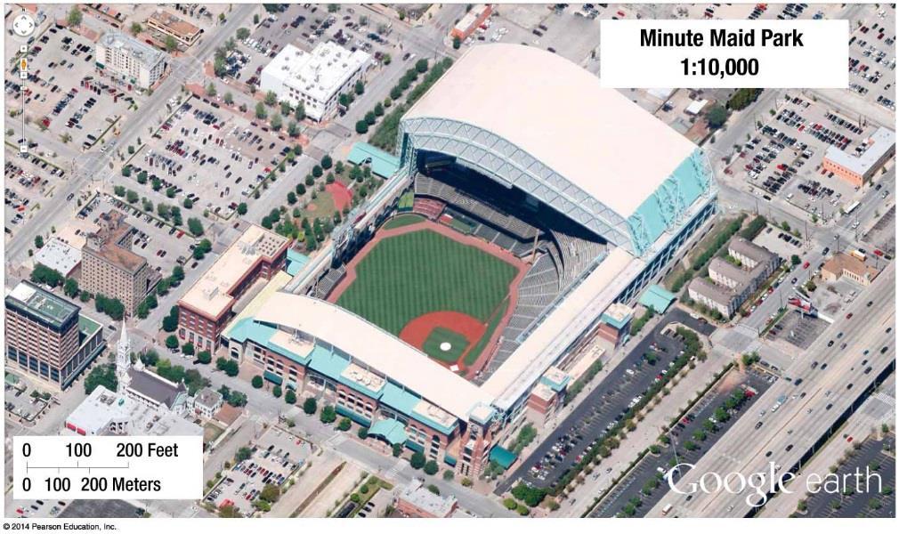
8 Scale Differences Maps of Washington State Small Scale Map Large Scale Map Which is the small scale map? Which is the large scale map? * Distortion is greatest in small scale (large area) maps! 8


9 Which illustration above best represents a small scale map? Which illustration above best represents a large scale map? 9


10 Importance of Scale Scale allows geographers to look at places on a local, regional, national, or global scale Processes operating at different scales influence one another. What is occurring across scales provides context for geographers to understand a phenomenon. People can use scale politically to change who is involved or how an issue is perceived.
11 Map Projections Map Projection scientific method of transferring locations on Earth s surface to a flat map All maps LIE!!! No perfect map projection depends on your data and the purpose of the map Four major types of map distortions Shape can be distorted appears more elongated or squat Distance between two points becomes increased or decreased Relative Area altered so that one area may appear larger than another, but in reality it may be smaller Direction from one place to another can be distorted Most maps in this course will be equal area projections relative sizes on the landmasses are the same as they are in reality 11
")
12 Mercator Projection Preserves accurate compass direction, distorts landmasses relative to each other Landmasses most distorted near the poles (high latitudes) 12

13 Peters Projection Retains the accurate sizes of all the world s landmasses Distortion near the equator (low latitudes) 13

14 Mollweide Projection Pseudo cylindrical projection Central meridian and parallels straight, but not other meridians 14

15 Robinson Projection Minimizes the errors in area, shape, distance, and direction land areas smaller Aesthetically pleasing balance good for displaying information across oceans 15

16 Azimuthal (planar) Projection Planar (polar) projections Formed when flat piece of paper is placed on top of the globe and light source projects surrounding areas on the map 16

17 Goodes-Homosoline Interrupted Projection Interrupted equal area map projection used for data representation 17

18 Fullers Projection Maintains accurate size and shape of landmasses, but completely rearranges direction 18
19 Key Concepts and Skills of Geographical Perspective Absolute Location exact position of an object or place, measured within the spatial coordinates of a grid system Longitude (meridians) lines that run north/south prime meridian at 0º Begin at 0º and go east and west until 180º Longitude lines never touch each other Latitude (parallels) lines that run east/west equator is at 0º Begin at 0º and go north and south until 90º Time Zones Telling Time Longitude plays an important role in calculating time Telling time using longitude - 360º divided by 24 = 15 15º east/west will enter a new time zone - - moving east turn clock ahead, moving west turn clock backward Greenwich Mean Time - prime meridian at 0º International Date Line - 180º longitude 19


20 Latitude and Longitude 20

21 Time Zones 21
 of a")
22 Climate Map General information about the climate and precipitation (rain and snow) of a region 22

23 Economic Map Feature the type of natural resources or economic activity that dominates an area 23

24 Physical Map Illustrate the physical features of an area, such as mountains, rivers, and lakes. Colors are used to show relief differences in land elevations 24


25 Graduated Symbol Map Graduated Symbol maps use symbols of different sizes to represent the numerical values of an attribute. The size of the symbol is proportional to the value of the attribute it symbolizes. Graduated Symbol maps are useful for illustrating quantitative information, such as traffic volume, earthquakes of different magnitudes, and population. 25

26 Political Map Indicate state and national boundaries and capital and major cities 26

27 Cartogram Map Present statistics in a pictorial way. A cartogram might show countries of the world in their proper map position, but with each country distorted to a size proportionate to its population World Population Cartogram 27

28 Topographic (Isoline) Map Include contour (isoline) lines to show the shape and elevation of an area. Lines that are close together indicate steep terrain, and lines that are far apart indicate flat terrain 28

29 Dot Map Use points to show precise locations of specific observations or occurrences Show frequency of events or phenomena Distribution of commercial wireless antennas in the USA. 29


30 Choropleth Map Use colors or tonal shadings to represent categories of data for given geographic areas (Darker colors usually show higher amount/percentage) 30

31 Flow-Line Map Typically use arrows to illustrate movement Used often in human geography to illustrate migration movement 31

32 Cognitive (Mental) Map Inform people s spatial behavior Individuals internal geographic understanding of a place 32
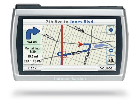
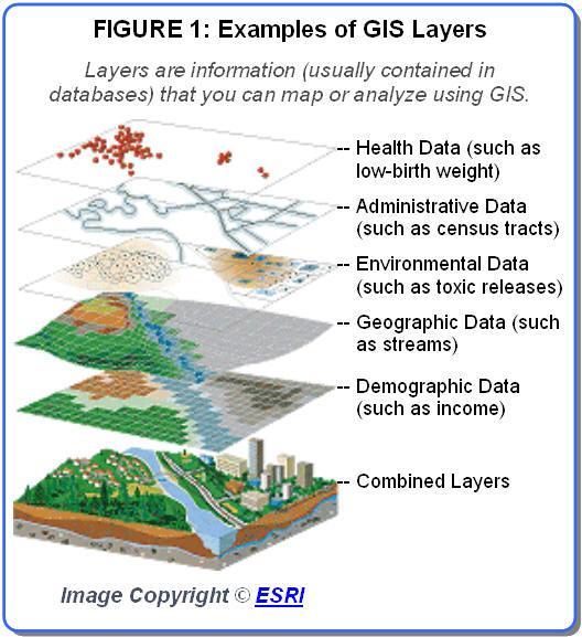
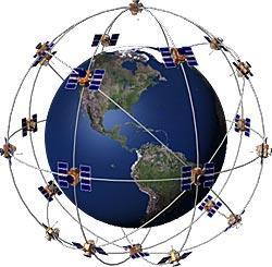
33 Use and Interpret Geospatial Data Remote Sensing Capturing image of earth s surface from airborne platforms Use of satellites and airplanes (single one at a time) Acquisition of data about Earth s surface from a satellite orbiting Earth or from other long distance methods is known as remote-sensing Global Positioning Systems (GPS) Series of satellites, tracking stations, and receivers determine precise locations Use latitude/longitude to determine exact location on Earth Used primarily for navigation Applications Turn-By-Turn directions in vehicles Navigational aid to pilots and ship captains Provide location for social media applications in a smartphone Geographic Information Systems (GIS) Computer system that captures, stores, analyzes, and displays data Information stored in layers, which will be combined to present an overall image Thematic layers Online Mapping Google Maps - Mapquest 33


34 Remote Sensing GIS GPS 34

35 Layers can be compared to show relationships among different kinds of information. Data can be overlaid in one GIS from a variety of different sources through a process known as a mashup. 35

36 Geographic Information System Thematic Layers!! 36
Key Issue #1. How do geographers describe where things are? 2014 Pearson Education, Inc.
 Key Issue #1 How do geographers describe where things are? Learning Outcomes 1.1.1: Explain differences between early maps and contemporary maps. 1.1.2: Describe the role of map scale and projections and
Unit 1 All. Study online at quizlet.com/_3l51hr
 Unit 1 All Study online at quizlet.com/_3l51hr 1. geography: 4. 7 APHG Units+: The study of the distribution and interaction of physical and human features on the earth 2. physical geography: 1. Geography:
Wayne E. Sirmon GEO 301 World Regional Geography
 Wayne E. Sirmon GEO 301 Geography 301 Geography 301 MAP: A graphic representation of a portion of the earth s surface dawn to scale, as seen from above. Types of Maps Climate maps give general information
Pool Canvas. Add. Creation Settings. Chapter 1--Objectives and Tools of World Regional Geography. Description Instructions.
 1 of 6 TEST BANK > CONTROL PANEL > POOL MANAGER > POOL CANVAS Pool Canvas Add, modify, and remove questions. Select a question type from the Add Question drop-down list and click Go to add questions. Use
Chapter 1: The World of Geography
 Chapter 1: The World of Geography Chapter 1: What is Geography? *It is the study of our earth; our home. OR *Anything that can be mapped! *Geography mixes up the physical and human aspects of our world
Number in your response section 1-5. Write the letter to the matching Theme of Geography. (Do not use your notes)
") Matching/Review Number in your response section 1-5. Write the letter to the matching Theme of Geography. (Do not use your notes) 1. Location a. The ability of people, goods, and ideas to spread from one
Matching/Review Number in your response section 1-5. Write the letter to the matching Theme of Geography. (Do not use your notes) 1. Location a. The ability of people, goods, and ideas to spread from one
Chapter 3 Models of the Earth. 3.1 Finding Locations on the Earth. 3.1 Objectives
 Chapter 3 Models of the Earth 3.1 Finding Locations on the Earth 3.1 Objectives Explain latitude and longitude. How can latitude and longitude be used to find locations on Earth? How can a magnetic compass
Chapter 02 Maps. Multiple Choice Questions
 Chapter 02 Maps Multiple Choice Questions 1. Every projection has some degree of distortion because A. a curved surface cannot be represented on a flat surface without distortion. B. parallels and meridians
Name Class Date. For each pair of terms, explain how the meanings of the terms differ.
 Skills Worksheet Chapter Review USING KEY TERMS For each pair of terms, explain how the meanings of the terms differ. 1. true north and magnetic north 2. latitude and longitude 3. equator and prime meridian
Different types of maps and how to read them.
 Different types of maps and how to read them. A map is a picture or representation of the Earth's surface, showing how things are related to each other by distance, direction, and size. Maps have been
Cartography = Science of Mapmaking
 Mapping Cartography = Cartography = Science of Mapmaking Eratosthenes (Era TOS the neez) Ancient Greek Librarian at Alexandria in Egypt (3rd c. BCE). First accurate measurement of circumference of the
AP Human Geography Unit I: Intro to Geography
 Thinking Geographically: Key Issue 1 What Is Human Geography? De Blij pp. 1 9 1. According to the text, how many people are malnourished in the world? 2. World Hunger Use the map on page 2 3 in your textbook
Introduction to Geography
 Introduction to Geography What is geography? Geography comes from the Greek word Geographia. Geo means earth and graphia means to describe or chart. Geographers study the earth in relation to space and
Key Issue #1 - Why is Geography a Science?
 AP Human Geography - 1 Rubenstein s The Cultural Landscape Chapter 1: Thinking Geographically Introduction to Note Packets Reading the textbook and taking notes while reading are NECESSARY steps in processing
1. Define map: 2. Name and define the five concepts that guide geographers a) 3. Define cartography: MAPS 4. A map serves two purposes a)
 3. Define cartography: MAPS 4. A map serves two purposes a)") 1. Define map: 2. Name and define the five concepts that guide geographers c) d) e) 3. Define cartography: MAPS 4. A map serves two purposes 5. Give two examples of early mapmaking and its (unusual?) materials
1. Define map: 2. Name and define the five concepts that guide geographers c) d) e) 3. Define cartography: MAPS 4. A map serves two purposes 5. Give two examples of early mapmaking and its (unusual?) materials
netw rks Guided Reading Activity Essential Question: How does geography influence the way people live? What Is Geography?
 Guided Reading Activity What Is Geography? Lesson 1 Thinking Like a Geographer Essential Question: How does geography influence the way people live? Directions: Read the lesson and use your textbook to
What is Geography? *Mixes up the physical and human aspects of our world into one field of study.
 World Geography What is Geography? *It is the study of the earth *Mixes up the physical and human aspects of our world into one field of study. *Shows the relationship between people and the environment.
5. How has globalization hindered the nation of Kenya?
 Thinking Geographically: Key Issue 1 What Is Human Geography? De Blij pp. 1-9 1. According to the text, how many people are malnourished in the world? 2. World Hunger - Use the map on page 2-3 in your
History of Cartography,
 Maps History of Cartography, the art and science of making maps ~2300 BC ~600 BC Early oldest known maps: Babylonian clay tablets. Greek and Roman Ptolemy s (about AD 85-165) "world map" depicted the Old
Chapter 1 Learning Guide Thinking Geographically
 Chapter 1 Learning Guide Thinking Geographically Key Issue 1 How Do Geographers Address Where Things Are? Pgs. 2 13 1. Define map: 2. Define cartography: Maps 3. Give an example of early mapmaking and
Map Skills and Geographic Tools
 Name: Period: Map Skills and Geographic Tools TEKS: 8.9C interpret topographic maps and satellite views to identify land and erosional features and predict how these features may be reshaped by weathering
Unit 1 The Basics of Geography. Chapter 1 The Five Themes of Geography Page 5
 Unit 1 The Basics of Geography Chapter 1 The Five Themes of Geography Page 5 Geography comes from the Greek word geographia, which means to describe the earth. Geography is the study of the distribution
2. What does the map scale tell the map reader? a ratio between the actual distance on the ground and the length given to that distance on a map
 AP Human Geography - Damon Name Unit 1 - Intro to Human Geography Hour Map and Globe Skills Review Note: All links in this packet are found on our Wikispace under Map and Globe Skills Review First, read
6. Provide an example of developments in geography for each of the following:
 Thinking Geographically: Key Issue 1 How Do Geographers Describe Where Things Are? Rubenstein, p. 5-13 1. Define map: 2. Define cartography: MAPS 3. Give two examples of developments in early mapmaking.
3. Give two examples of early mapmaking and its (unusual?) materials for the maps. (a)
 materials for the maps. (a)") Thinking Geographically: Key Issue 1 How Do Geographers Describe Where Things Are? Rubenstein Ch. 1 pp. 4 12 1. Define map: 2. Define cartography: MAPS 3. Give two examples of early mapmaking and its (unusual?)
Thinking Geographically: Key Issue 1 How Do Geographers Describe Where Things Are? Rubenstein Ch. 1 pp. 4 12 1. Define map: 2. Define cartography: MAPS 3. Give two examples of early mapmaking and its (unusual?)
MR. GOFF S WORLD HISTORY UNIT ONE: GEOGRAPHY 5 THEMES OF GEOGRAPHY
 MR. GOFF S WORLD HISTORY UNIT ONE: GEOGRAPHY 5 THEMES OF GEOGRAPHY BYOD BRING YOUR OWN DEVICE IN SMALL GROUPS (3-4), USE YOUR ELECTRONIC DEVICE(S) AND DEFINE THE FOLLOWING VOCAB. WORDS 1. GEOGRAPHY 2.
About places and/or important events Landmarks Maps How the land is, hills or flat or mountain range Connected to maps World Different countries
 What do you think you know about geography? About places and/or important events Landmarks Maps How the land is, hills or flat or mountain range Connected to maps World Different countries What do you
UNIT 1 THE BASICS OF GEOGRAPHY
 UNIT 1 THE BASICS OF GEOGRAPHY CHAPTER 1 LOOKING AT THE EARTH 1 Section 1.1: The 5 Themes of Geography.Geography comes from a Greek word meaning writing about or describing the earth. Geography is: Geographers
Geography Test Unit 1 Study Guide. democracy profit citizenship Bill of Rights consumers federal government political process values
 Geography Test Unit 1 Study Guide Skills Identify Longitude and Latitude Identify Continents of the World Identify Time Zones Equator Prime Meridian Hemispheres Map Requirements Oceans Compare US/Mexico/Canada
Unit I Terms. 1.1 Terms
 Unit I Terms 1.1 Terms Space Def: area Sig: space, or spatial analysis, is at the heart of geography (like time is to historians) Projection Def: The system used to transfer locations from earth s surface
Maps: Geography s Basic Tools
 Maps: Geography s Basic Tools What is a map? - A map is a representation of the earth s features drawn on a flat surface. - Maps use points, lines, colours, and symbols to represent the features of an
Chapter 1: Basic Concepts
 Chapter 1: Basic Concepts The Cultural Landscape: An Introduction to Human Geography Defining Geography Word coined by Eratosthenes Geo = Earth Graphia = writing Geography thus means earth writing Contemporary
What Is a Globe? Hemispheres. Main Idea Globes and maps provide different ways of showing features of the earth. Terms to Know
 r Main Idea Globes and maps provide different ways of showing features of the earth. Terms to Know hemisphere latitude longitude scale bar scale relief elevation contour line What Is a Globe? A globe is
Mapping Earth. How are Earth s surface features measured and modeled?
 Name Mapping Earth How are Earth s surface features measured and modeled? Before You Read Before you read the chapter, think about what you know about maps Record your thoughts in the first column Pair
Geography Can Be Cool. Seriously
 Geography Can Be Cool Seriously Why does geography matter? Geography: the study of looking at every aspect of the Earth s systems, such as human economies, societies, cultures, plants, animals, & climate.
CHAPTER EXIT CHAPTER. Models of Earth. 3.1 Modeling the Planet. 3.2 Mapmaking and Technology. 3.3 Topographic Maps CHAPTER OUTLINE
 EXIT CHAPTER.1 Modeling the Planet.2 Mapmaking and Technology. Topographic Maps CHAPTER OUTLINE CHAPTER.1 Modeling the Planet A flat of Earth is a convenient tool, but it can distort the shape, distance,
Unit 1 Chapter 1. Thinking Geographically * Basics of Geography
 Global Cultures Unit 1 Chapter 1 Thinking Geographically * Basics of Geography 1.1 Geography in Greek means writing about the Earth study the Earth Geography Geographer asks: WHERE things are found on
What is a map? A Map is a two or three-dimensional model or representation of the Earth s surface. 2-Dimensional map
 What is a map? A Map is a two or three-dimensional model or representation of the Earth s surface. 2-Dimensional map What is a Map Projection? Planar Projection Projection A Projection is a mathematical
Key Issue 1: How Do Geographers Describe Where Things Are?
 Key Issue 1: How Do Geographers Describe Where Things Are? Pages 5-13 ***Always keep your key term packet out whenever you take notes from Rubenstein. As the terms come up in the text, think through the
Key Issue 1: How Do Geographers Describe Where Things Are?
 Key Issue 1: How Do Geographers Describe Where Things Are? Pages 5-13 and some information from pages 15-18. ***Always keep your key term packet out whenever you take notes from Rubenstein. As the terms
Geography involves the study of places: their locations, their characteristics, and how humans use and move around them.
 Physical Geography Looking at the Earth Geography involves the study of places: their locations, their characteristics, and how humans use and move around them. NEXT Physical Geography Looking at the Earth
EXTRA CREDIT Extra Credit Atlas Exercise for Exam I is available on the course home page
 EXTRA CREDIT Extra Credit Atlas Exercise for Exam I is available on the course home page. Submit answers to me using the blue Scantron sheet by Feb. 19, 2019. Once you have completed the exercise, transfer
THE EARTH AND ITS REPRESENTATION
 UNIT 7 THE EARTH AND ITS REPRESENTATION TABLE OF CONTENTS 1 THE EARTH AND THE SOLAR SYSTEM... 2 2 THE EARTH S MOVEMENTS... 2 2.1 Rotation.... 2 2.2 The revolution of the Earth: seasons of the year....
Key Issue 1: How Do Geographers Describe Where Things Are?
 Key Issue 1: How Do Geographers Describe Where Things Are? Pages 5-13 ***Always keep your key term packet out whenever you take notes from Rubenstein. As the terms come up in the text, think through the
Map Skills Unit. Note taking unit
 Map Skills Unit Note taking unit Introduction To learn about the Earth, we are going to learn about two geographic tools you can use.globes and maps. Globe A globe is a round model of the planet Earth
Topographic Maps and Landforms Geology Lab
 Topographic Maps and Landforms Geology Lab Ray Rector: Instructor Today s Lab Activities 1) Discussion of Last Week s Lab 2) Lecture on Topo Maps and Elevation Contours 3) Construct Topographic Maps and
Mapping Our World Chapter 2
 Mapping Our World Chapter 2 Section 2.1: Latitude and Longitude Maps are flat models of threedimensional objects. For thousands of years people have used maps to define borders and to find places. With
MULTIPLE CHOICE. Choose the one alternative that best completes the statement or answers the question.
 Practice Chapter 1 Exam Name MULTIPLE CHOICE. Choose the one alternative that best completes the statement or answers the question. 1) The historic diffusion of HIV/AIDS in the United States is an example
Test Bank Chapter 2: Representations of Earth
 Multiple Choice Test Bank Chapter 2: Representations of Earth 1. A rhumb line on a Mercator projection is a line of. a. true size b. true shape c. true compass bearing d. true location 2. Maximum longitude
The World of Geography Pre-Test/Study Guide Chapter 1 Test
 Read each statement or question. On the lines below write the letter of the best answer. 1. Geographers look at the Earth 5. What are the two specific A. by studying cities first. measurements of Earth
Unit 1 Geography and Perspectives
 Unit 1 Geography and Perspectives History of Geography Began thousands of years ago with Eratosthenes and Ptolemy as mapmaking Eratosthenes calculated the circumference of the earth, only off by 175 km!
What is Geography? Lecture 1 The Earth As A Rotating Planet. What is Geography? What is geography? Subfields of Geography?
 Lecture 1 The Earth As A Rotating Planet Geog210 Physical Geography What is Geography? Much more than place names and locations The study of spatial variation How and why things differ from place to place
Introduction to Cartography Part II
 Introduction to Cartography Part II Introduction to Cartography Map Projections GIS GPS Remote Sensing Misrepresentation with Maps Map Projections Mathematical method for systematically transforming a
0 questions at random and keep in order
 Page 1 of 5 This chapter has 36 questions. Scroll down to see and select individual questions or narrow the list using the checkboxes below. 0 questions at random and keep in order s - (20) - (11) / Questions
AP Human Geography Unit 1: Basic Concepts and Development Mr. Stepek Guided Reading/Study Guide
 AP Human Geography Unit 1: Basic Concepts and Development Mr. Stepek Guided Reading/Study Guide Directions: Follow the common directions distributed to you for guided reading assignments. Rubenstein p
Chapter 2: Studying Geography, Economics, and Citizenship
 Chapter 2: Studying Geography, Economics, and Citizenship Lesson 2.1 Studying Geography I. Displaying the Earth s Surface A. A globe of the Earth best shows the sizes of continents and the shapes of landmasses
EXTRA CREDIT. 6 Geographers Tools. Maps and their Parts MAP MAKING QUANDRY MAP MAKING
 EXTRA CREDIT Extra Credit Atlas Exercise for Exam I is available on the course home page. Submit answers to me using the blue Scantron sheet by Feb. 19, 2019. Once you have completed the exercise, transfer
EXTRA CREDIT. 6 Geographers Tools. Maps and their Parts MAP MAKING QUANDRY MAP MAKING 2/15/19 MAP PROJECTIONS MAP PROJECTIONS
 EXTRA CREDIT Extra Credit Atlas Exercise for Exam I is available on the course home page. Submit answers to me using the blue Scantron sheet by Feb. 19, 2019. Once you have completed the exercise, transfer
Geography by its nature is a spatial science. Geographers therefore study space in order to locate the distribution of people and objects.
 Geography by its nature is a spatial science. Geographers therefore study space in order to locate the distribution of people and objects. Geographers ask two main questions, where and why. Spatial analysis
ESSENTIAL QUESTIONS. Write these down in your notes. 1. How does the way geographers look at the world differ from that of others scientists?
 ESSENTIAL QUESTIONS Write these down in your notes 1. How does the way geographers look at the world differ from that of others scientists? 2. How has the sense of the world changed from the first maps
AP HuG Summer
 AP HuG Summer 2017-2018 Welcome to AP Human Geography! I look forward to having you in class next year. For many of you an AP class is a new concept, and you may be wondering what AP entails. An AP course
May 18, Dear AP Human Geography Student,
 May 18, 2018 Dear AP Human Geography Student, This fall many exciting challenges and opportunities await you in AP Human Geography. As the title indicates, this is a college-level course. Its format follows
Chapter One. Thinking Geographically
 Chapter One Thinking Geographically Where are you? Tell me where you are. How do you know? Important Terms Map two dimensional or flat scale model of the Earth. Place A specific Point on the Earth s surface.
PLEASE DO NOT WRITE ON THIS EXAM BOOKLET!
 Unit 1 Exam Version A PLEASE DO NOT WRITE ON THIS EXAM BOOKLET! 1) The importance of the spatial approach that geographers use in their studies is that it shows A) the arrangement and organization of things
Introduction to Geography
 Introduction to Geography ropic of Cancer 3½ N Arctic Circle 90 N Prime Meridian 0 Arctic Ocean Mississippi R. Appalachian Mts. Europe Rocky Mountains N. America Atlantic Gulf of Ocean Mexico Caribbean
Referencing map features: Coordinate systems and map projections
 Referencing map features: Coordinate systems and map projections Coordinate systems and map projections if we want to integrate geographic data from many different sources, we need to use a consistent
Chapters 1-3 Test Review
 Chapters 1-3 Test Review Pre-AP World Geography 1. A Mercator projection is a common example of what type of projection? 2. A Robinson projection looks similar to what type of projection, except its east-west
Location. Look over the indicators of location on your handout. What things about Baltimore s location make it unique from other places?
 Objective We will review the 5 Themes of Geography to explain why each place on earth is unique. We will apply the concepts related to the 5 Themes of Geography to Baltimore Tuesday, September 7, 2010
Introduction to Cartography Part I
 Introduction to Cartography Part I Introduction to Cartography Maps vs. Globes General Types of Maps Standard Map Features Maps versus Globes Map: a representation of the world, or part of it, in two dimensions
MR. JOHNSON S. Geography OHIO COUNTY MIDDLE SCHOOL
 MR. JOHNSON S Geography OHIO COUNTY MIDDLE SCHOOL CHAPTER 1 Geography The science of geography is likely the oldest of all sciences. Geography is the answer to the question that the earliest humans asked,
STUDY GUIDE. Exploring Geography. Chapter 1, Section 1. Terms to Know DRAWING FROM EXPERIENCE ORGANIZING YOUR THOUGHTS
 For use with textbook pages 19 22. Exploring Geography Terms to Know location A specific place on the earth (page 20) absolute location The exact spot at which a place is found on the globe (page 20) hemisphere
REPRESENTATIONS OF EARTH
 2 REPRESENTATIONS OF EARTH Chapter Outline MAPS AND LOCATION ON EARTH Earth s Shape and Size Globes and Great Circles Latitude and Longitude THE GEOGRAPHIC GRID Parallels and Meridians Longitude and Time
Ch2&3 Test. Multiple Choice Identify the choice that best completes the statement or answers the question.
 Ch2&3 Test Multiple Choice Identify the choice that best completes the statement or answers the question. 1. Earth s circumference is about 40,000 km, and its shape is a. an oval. c. a perfect sphere.
By what two factors do geographers observe that people are being pulled in opposite directions? factors.
 By what two factors do geographers observe that people are being pulled in opposite directions? A. latitude and longitude B. government and religion factors. C. human and physical geography D. globalization
3. What is the etymology (how the word came to be) of geography. 4. How does the study of physical geography differ from that of human geography?
 of geography. 4. How does the study of physical geography differ from that of human geography?") AP Human Geography Unit 1: Basic Concepts and Development Guided Reading Mr. Stepek Directions: Follow the common directions distributed to you for guided reading assignments. Rubenstein p 2 5 (Introduction)
AP Human Geography Unit 1: Basic Concepts and Development Guided Reading Mr. Stepek Directions: Follow the common directions distributed to you for guided reading assignments. Rubenstein p 2 5 (Introduction)
CHAPTER 1: KEY ISSUE 1 How Do Geographers Describe Where Things Are? p. 4-13
 CHAPTER 1: KEY ISSUE 1 How Do Geographers Describe Where Things Are? p. 4-13 Always keep your vocabulary packet out whenever you take notes. As the term comes up in the text, add to your examples for the
Understanding Projections
 GEOGRAPHY SKILLS 1 Understanding Projections The earth is a sphere and is best shown as a globe. For books and posters, though, the earth has to be represented as a flat object. To do this, mapmakers create
2. Environmental issues in the relationship of humankind to the environment
 Course Goals to Understand 1. Processes operating on the earth s surface Atmosphere Lithosphere Hydrosphere Biosphere 2. Environmental issues in the relationship of humankind to the environment 3. Science
Some of these parallels are very important. In the Northern Hemisphere, there is the Tropic of Cancer and the Arctic Circle.
 PDF 2 Geographic coordinates 1 The geographic coordinates system is network of imaginary horizontal and vertical lines that are drawn on globes or maps. These lines are called parallels (lines of latitude)
Tonight. {01} The map. Relative space. What does a map do? Types of maps GEOG 201 2/17/2010. Instructor: Pesses 1
 Tonight {01} The map What makes a map Measuring the Earth Map Interpretation & GPS Spring 2010 M. Pesses What does a map do? Shows where things are Shows spatial (topological) relationships Shows patterns,
Do Maps Create or Represent Reality? by Laura Herbert
 Do Maps Create or Represent Reality? by Laura Herbert Have you ever stopped and really looked at a map? I m not talking about consulting the coffee- stained map that makes its home in your glove compartment;
A. Spatial Sense (Working with Maps, Globes, and Other Geographic Tools)
") A. Spatial Sense (Working with Maps, Globes, and Other Geographic Tools) Measuring Distance Using Map Scale All maps are drawn to scale; that is, they are smaller than the things they represent. Scale
A. Spatial Sense (Working with Maps, Globes, and Other Geographic Tools) Measuring Distance Using Map Scale All maps are drawn to scale; that is, they are smaller than the things they represent. Scale
AP Human Geography. Basic Concepts
 AP Human Geography Basic Concepts An in-depth Social Science Many people have misconceptions about geography and think of the discipline as simply an exercise in memorizing place names. Where we find Geography?
Map Projections. is about presenting the round Earth on a flat surface.map Projections: Vermeer s Cartographer
 Map Projections is about presenting the round Earth on a flat surface.map Projections: Vermeer s Cartographer What is a map projection? A projection is a way to make a flat representation of the Earth
Parts of a Map. Map Skills. The Title. There are 4 main parts of a map: The Title The Compass Rose The Map Key The Scale
 Map Skills Parts of a Map There are 4 main parts of a map: The Title The Compass Rose The Map Key The Scale The Title The title of the map is usually at the top and describes the topic of the map Example:
Unit 1, Lesson 2. What is geographic inquiry?
 What is geographic inquiry? Unit 1, Lesson 2 Understanding the way in which social scientists investigate problems will help you conduct your own investigations about problems or issues facing your community
The Elements of GIS. Organizing Data and Information. The GIS Database. MAP and ATRIBUTE INFORMATION
 GIS s Roots in Cartography Getting Started With GIS Chapter 2 Dursun Z. Seker MAP and ATRIBUTE INFORMATION Data (numbers and text) store as files refer to them collectively as a database gather inform.
5 Themes of Geography Review Video Notes What is Geography?
 Name PG # 5 Themes of Geography Review Video Notes What is Geography? The study of, their, and their Main Idea or Topic Continents Notes about Main Idea or Topic There are 7 Continents or in the world:
ADVANCED PLACEMENT HUMAN GEOGRAPHY
 ADVANCED PLACEMENT HUMAN GEOGRAPHY Unit One Geography: Its Nature and Perspectives Session 3 INTERPRETATION OF PLACES AND PATTERNS PLACE: THE GEOGRAPHIC TERM Place is deceptively complex. Place describes
Using Maps. Using Maps. Using Maps. Using Maps
 A is a visual representation, or model, of part or all of the earth. lines are imaginary lines that run east to west around the globe; they are also known as parallels. They show distances in degrees north
ENV208/ENV508 Applied GIS. Week 2: Making maps, data visualisation, and GIS output
 ENV208/ENV508 Applied GIS Week 2: Making maps, data visualisation, and GIS output Overview GIS Output Map Making Types of Maps Key Elements GIS Output Formats Table Graph Statistics Maps Map Making Maps
Overview. GIS Data Output Methods
 Overview GIS Output Formats ENV208/ENV508 Applied GIS Week 2: Making maps, data visualisation, and GIS output GIS Output Map Making Types of Maps Key Elements Table Graph Statistics Maps Map Making Maps
Name: Date: Period: #: Chapter 1: Outline Notes What Does a Historian Do?
 Name: Date: Period: #: Chapter 1: Outline Notes What Does a Historian Do? Lesson 1.1 What is History? I. Why Study History? A. History is the study of the of the past. History considers both the way things
1. Origins of Geography
 II. ORIGINS AND BRANCHES OF GEOGRAPHY My Notes A. Origins of Geography Unit One 6 Before carefully examining the tools of the geographer, it would be useful to examine the origins and roots of this ancient
Shape e o f f the e Earth
 1 Coordinate Systems & Projections Coordinate Systems Two map layers are not going to register spatially unless they are based on the same coordinate system. 2 Contents Shape of the earth Datum Projections
Geographers Perspectives on the World
 What is Geography? Geography is not just about city and country names Geography is not just about population and growth Geography is not just about rivers and mountains Geography is a broad field that
Unit 1: Introduction: Thinking Geographically, Basic Concepts
 Unit 1: Introduction: Thinking Geographically, Basic Concepts 38:180 Human Geography What does it mean to think like a geographer? Memorizing places? Countries, capital cities, rivers, etc School Geography
Map Skills Test. 1. What do we call a person who makes maps? a. mapographer b. cartographer c. geologist d. archaeologist
 Map Skills Test 1. What do we call a person who makes maps? a. mapographer b. cartographer c. geologist d. archaeologist 2. What is the name of the 0 latitude line? a. Equator b. Arctic Circle c. First
FIND PLACES ON GLOBES USING LATITUDE
 GLOBES, MAPS & GRAPHS FIND PLACES ON GLOBES USING LATITUDE AND LONGITUDE LINES FIND PLACES ON MAPS USING A GRID SYSTEM NAME SEVERAL TYPES OF MAP PROJECTIONS AND EXPLAIN THEIR BENEFITS AND SHORTCOMINGS