The German Marine Data Infrastructure (MDI-DE)
|
|
|
- Lillian Johnston
- 5 years ago
- Views:
Transcription
1 The German Marine Data Infrastructure (MDI-DE)

2 Marine Data Infrastructure (MDI-DE) German EEZ

3 Marine Data Infrastructure (MDI-DE) Data Originators 18 Agencies and Institutions in the EEZ and 12 Mile Zone Federal Government Federal Government BSH BfN Schleswig-Holstein LKN-LLUR Federal Government BAW Mecklenburg-Vorpommern LUNG Niedersachsen NLWKN NLPV

4 Marine Data Infrastructure (MDI-DE) For which Systems do we need Data IODE MyOcean INSPIRE OSPAR CISE GEBCO HELCOM SeaDataNet MaNIDA Copernicus InSitu ICES MUDAB BOOS EMODnet NOOS MSFD BaltSeaPlan TMAP WFD WasserBLIcK AufMod GDI-DE
5 Marine Data Infrastructure (MDI-DE) MDI-DE Project MDI-DE = Marine Data Infrastructure - Germany Supra-institutional network for the integration of marine data from all relevant data sources National Institutions Federal Institutions Research Organizations National marine and coastal information system Central geoportal Central metadata catalogue Local infrastructure nodes providing data Funded by the German Ministry of Education and Research
 Subproject 2: Marine Environmental Protection Lead: Federal Maritime and Hydrographic Agency (BSH) Subproject 3: Marine Nature Conservation Lead: Federal Agency for Nature")
6 Subprojects Marine Data Infrastructure (MDI-DE) Joint Project with 4 Subprojects Subproject 1: Coastal Engineering and Protection of Coastal Waters Lead: Federal Waterways Engineering and Research Institute (BAW) Subproject 2: Marine Environmental Protection Lead: Federal Maritime and Hydrographic Agency (BSH) Subproject 3: Marine Nature Conservation Lead: Federal Agency for Nature Conservation (BfN) Subproject 4: Scientific and Technical Accompanying Research Lead: Institute for Geodesy and Geoinformatics (University of Rostock) Project duration: 42 months (projected: until ) Funding period: 30 months Funded by the Federal Ministry of Education and Research

7 Marine Data Infrastructure (MDI-DE) Team Members Federal Waterways Engineering and Research Institute (Coastal Engineering) BAW Hamburg Schleswig-Holstein s Government-Owned Company for Coastal Protection, National Parks and Ocean Protection, LKN Husum and Tönning Lower Saxony agency for water management, coastal and nature conservation NLWKN Branches Norden-Norderney and Brake-Oldenburg Lower Saxony Wadden Sea National Park Administration, NLPV Wilhelmshaven Directorates of Water and Navigation, WSD Northwest, Aurich / North, Kiel Federal Maritime and Hydrographic Agency (Marine Environment) BSH Hamburg State Agency for Agriculture, Environment and Rural Areas Schleswig-Holstein, LLUR Flintbek State Agency for Environment, Nature Conservation and Geology Mecklenburg-West Pommerania, LUNG Güstrow Federal Agency for Nature Conservation (Marine Nature Conservation) BfN, Bonn
8 Marine Data Infrastructure (MDI-DE) Project Partners AWI Alfred-Wegener-Institut BfG Bundesanstalt für Gewässerkunde BKG Bundesamt für Kartographie und Geodäsie CWSS Common Wadden Sea Secretariat HZG Helmholtz-Zentrum Geesthacht ICBM Institut für Chemie und Biologie des Meeres an der Uni Oldenburg GEOMAR, Helmholtz-Zentrum für Ozeanforschung Kiel IOW Institut für Ostseeforschung Warnemünde MARUM Zentrum für Marine Umweltwissenschaften der Universität Bremen PortalU Geschäftsstelle Umweltportal Deutschland Senckenberg Institut Senckenberg am Meer in Wilhelmshaven SH-MIS Schleswig-Holsteinisches Metainformationssystem UBA Umweltbundesamt Dessau vti-sf Johann Heinrich von Thünen-Institut, Institut für Seefischerei ZfG Zentrum für Geoinformation an der Uni Kiel
9 Marine Data Infrastructure (MDI-DE) Project Goals Development of a multidisciplinary network for integrating the major coastal data sources located at Federal and State public authorities and research centers, a new Web portal for Ocean and Coast, MDI-DE, a comprehensive national Ocean and Coastal Information System and a coordinated working environment relying on metadata and Web services. Benefits comprehensive provision of distributed marine data, improvement of workflows with data from heterogeneous coastal sources to produce data products to support political and economic decisions as well as for reporting and presentation in different target systems.
10 Marine Data Infrastructure (MDI-DE) Future Network Service Oriented Architecture Decentralized network of data providing services LKN LLUR Portal BAW MDI-DE GDI-BSH BSH NOKIS BfG Gazetteer BfN NN Data and Services documented with metadata NLWKN / NLPV Services Metadaten Daten Dienste Thesaurus vti Focus on interoperability WSDn Harvesting AWI open standards (ISO, OGC). LUNG HZG

 INSPIRE")


11 Marine Data Infrastructure (MDI-DE) Marine Data Infrastructure-Germany (MDI-DE) INSPIRE WRRL, SoE, FFH, HWRL, MSRL WISE-Marine OSPAR HELCOM (ICES) MUDAB TMAP MDI-DE Users: authorities, science, politics, economy, public
12 Marine Data Infrastructure (MDI-DE) Basic Architecture Central Geoportal Central Metadata Catalogue Infrastructure Nodes providing marine data
![Basic Workflow User [4] maps and data [1]](/docs-images/88/115939487/images/13-7.jpg "Search WMS = Web Map Service WFS = Web")


![1 CSW Metadata catalogue Mapviewer [3] map](/docs-images/88/115939487/images/13-10.jpg "request WMS/WFS Map 2 CSW Metadata catalogue")

13 Basic Workflow User [4] maps and data [1] Search WMS = Web Map Service WFS = Web Feature Service CSW = Cataloque Service for the Web MDI-DE Portal Metadata catalogue [2] harvesting CSW Metadata catalogue WMS/WFS Map and Featureserver Geo DB Infrastructure node 1 CSW Metadata catalogue Mapviewer [3] map request WMS/WFS Map and Featureserver Geo DB Infrastructure node 2 CSW Metadata catalogue WMS/WFS Map and Featureserver Geo DB Infrastructure node n


14 Common User Workflow


15 Eutrophication HELCOM, 2006: Development of tools for assessment of eutrophication in the Baltic Sea, Baltic Sea Environmental Proceedings No. 104
16 Marine Data Infrastructure (MDI-DE) Harmonization: Example Eutrophication The Nitrite-N-Layer of different agencies with their own styles The harmonized Nitrite-N-Layer with unified symbols and legend


17 Marine Data Infrastructure (MDI-DE) MSRL D5: Eutrophication (Nitrate-N)


18 Marine Data Infrastructure (MDI-DE) MSRL D5: INSPIRE compliant WFS


19 Marine Data Infrastructure (MDI-DE) MDI-DE Portal Data Search DataVisualisation Data Access


20 CONTIS (Continental Shelf Information System)


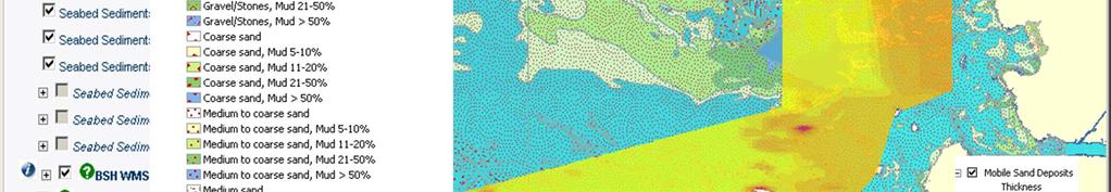

21 Sediments, Classification and Thickness


22 Spatial Subject Data: & Profile-Lines / Boreholes


23 Density of Harbour Porpoise Geodateninfrastruktur des BSH


24 Wrecks and Obstructions


25 Marine Data Infrastructure (MDI-DE) datadiver

26 Marine Data Infrastructure (MDI-DE) Summary and Outlook Use of a SDI can simplify the processes of providing data to different systems Data remains with its originators Minimal alteration to existing data structures Datasets could be provided for multiple uses Processing Services and SOS Thesaurus and Gazetteer datadiver will be integrated into the portal
27 Thank you for your attention. Questions?
Providing Marine Data. The German Marine Data Infrastructure (MDI-DE) as an example for best practice
 as an example for best practice") Providing Marine Data The German Marine Data Infrastructure (MDI-DE) as an example for best practice Data Originators 18 Agencies and Institutions in the EEZ and 12 Mile Zone Federal Government BSH Schleswig-Holstein
Providing Marine Data The German Marine Data Infrastructure (MDI-DE) as an example for best practice Data Originators 18 Agencies and Institutions in the EEZ and 12 Mile Zone Federal Government BSH Schleswig-Holstein
NOKIS - Information Infrastructure for the North and Baltic Sea
 NOKIS - Information Infrastructure for the North and Baltic Sea Carsten Heidmann 1 and Jörn Kohlus 2 Abstract 1. General The initial motivation for the project NOKIS (German title: Nord- und Ostsee-Küsteninformationssystem)
NOKIS an ISO Based Metadata System
 NOKIS an ISO 19115 Based Metadata System Carsten Heidmann BAW Hamburg (Tyskland) Overview Project NOKIS/NOKIS++ NOKIS Editor Metadata Infrastructure Germany NOKIS Tools: Survey Planning Tool Conclusions
NOKIS - Information Infrastructure for the North and Baltic Sea
 NOKIS - Information Infrastructure for the North and Baltic Sea Carsten Heidmann 1 and Jörn Kohlus 2 Abstract NOKIS, the North and Baltic Sea Coastal Information System, establishes an information infrastructure
Ready for INSPIRE.... connecting worlds. European SDI Service Center
 Ready for INSPIRE Consultancy SOFTWARE T r a i n i n g Solutions... connecting worlds European SDI Service Center Increasing Added Value with INSPIRE and SDI Components INSPIRE In 2007, the European Commission
INSPIRE Shared Service
 INSPIRE Shared Service Creation and operation out of the box Petra Fritz (HZD), Michael Voigtländer (Esri Deutschland GmbH) INSPIRE Shared Service Agenda HZD backbone for a geodata infrastructure Implementing
econtentplus GS Soil
 econtentplus GS Soil General aims Assessment and strategic development of INSPIRE compliant Geodata-Services for European Soil Data BPN on basis of the EU 2007/2/EC (INSPIRE) Directive for Annex III theme
Connecting SDI to an Open Data Portal The German Technical Adapter
 Connecting SDI to an Open Data Portal The German Technical Adapter INSPIRE-Geospatial World Forum, 28 May 2015, Lisbon Jürgen Walther Federal Agency for Cartography and Geodesy Outline Why participating
Local Spatial Data Infrastructure, a Solid Base for Sustainable Land Management in Germany
 Local Spatial Data Infrastructure, a Solid Base for Sustainable Land Management in Germany FIG Commission 3 Workshop and Commission 3 Annual Meeting The Empowerment of Local Authorities: Spatial Information
E-Government and SDI in Bavaria, Germany
 135 E-Government and SDI in Bavaria, Germany Wolfgang STOESSEL, Germany Key words: GDI-BY, Bavaria, Spatial Data Infrastructure SUMMARY Spatial Data Infrastructure (SDI) is an important part of the e-government
Introduction to EMODnet
 Introduction to EMODnet Antonio Novellino Torino, 14-15 Ottobre 2015 What is EMODnet? Initiated by the European Commission in response to the EU Future Maritime Policy and Blue Growth, launched in June
BalticBOOST Appendix 1, WP 3.3 Deliverable 1 Final report 14 February 2017
 Theme 1: Biodiversity This is a deliverable from the BalticBOOST project that was coordinated by HELCOM and co-financed by the European Union in 2015-2016 as part of the programme DG ENV/MSFD Action Plans/2016.
INSPIRE Coordination in Germany
 Inter-ministerial Committee for Geo Information INSPIRE Coordination in Germany The federal administrative level Pier-Giorgio Zaccheddu Head of Administration Office Inter-ministerial Committee for Geo
MSP Data Study. Overview of operational marine data infrastructures with potential relevance to the MSP process
 Overview of operational marine data infrastructures with potential relevance to the MSP process NAME URL TYPE MSP THEMES SCOPE SCOPE KEYWORDS e.g. physics, chemistry, biology, fish stocks, habitats,...
Marine Spatial Planning Experience from Mecklenburg-Vorpommern (Germany) By Susan Toben
 By Susan Toben") Marine Spatial Planning Experience from Mecklenburg-Vorpommern (Germany) By Susan Toben Ministry of Transport, Building and Regional Development Mecklenburg Vorpommern PlanCoast Lead Partner Administrative
Marine Spatial Planning Experience from Mecklenburg-Vorpommern (Germany) By Susan Toben Ministry of Transport, Building and Regional Development Mecklenburg Vorpommern PlanCoast Lead Partner Administrative
Turkey s National SDI Implementation
 Onur PAŞAOĞULLARI Head of Department Turkey s National SDI Implementation Presentation Plan NSDI Background General Directorate of Geographic Information Systems NSDI Project INSPIRE Directive Urban Information
12 th Polish German Seminar on Coastal Research The Baltic Sea at the middle of 21 th century
 Risk Analyis for Coastal Areas 12 th Polish German Seminar on Coastal Research The Baltic Sea at the middle of 21 th century M.Sc. Angelika Gruhn, Dipl.-Ing. Dörte Salecker, Prof. Dr.-Ing. Peter Fröhle
Innovation in Land Management: Integrated Solutions For National Cadastre Projects
 Success With GIS Innovation in Land Management: Integrated Solutions For National Cadastre Projects XXIII International FIG Congress Munich These documents are only complete, when used in connection with
Current Hydrographic Projects at BSH
 7 th Workshop Seabed Acoustics, Rostock, November 19/20, 2015 P01-1 Current Hydrographic Projects at BSH Thomas Dehling Federal Maritime and Hydrographic Agency (BSH) Germany Contact Address Website BSH
Identification of maritime spatial planning best practices in the Baltic Sea Region and other EU maritime regions
 Identification of maritime spatial planning best practices in the Baltic Sea Region and other EU maritime regions PLAN BOTHNIA Baltic Sea Region Stakeholder Meeting Jacek Zaucha, Magdalena Matczak Two
EMODnet High Resolution Seabed Mapping - further developing and providing a high resolution digital bathymetry for European seas
 EMODnet High Resolution Seabed Mapping - further developing and providing a high resolution digital bathymetry for European seas EGU Fall 2017 meeting New Orleans USA, December 2017 Schaap Dick MARIS,
INSPIRE Data Harmonization and Network Services at the German Federal Institute of Hydrology (BfG) Klaus Fretter BfG Sören Dupke con terra
 Klaus Fretter BfG Sören Dupke con terra") INSPIRE Data Harmonization and Network Services at the German Federal Institute of Hydrology (BfG) Klaus Fretter BfG Sören Dupke con terra Outline Introduction BfG Approach used > Matching > Mapping >
INSPIRE Data Harmonization and Network Services at the German Federal Institute of Hydrology (BfG) Klaus Fretter BfG Sören Dupke con terra Outline Introduction BfG Approach used > Matching > Mapping >
Harmonisation of Spatial Planning Data
 INSPIRE Conference 18 June 2011 Edinburgh, Great Britain Harmonisation of Spatial Planning Data Tomas Mildorf University of West Bohemia mildorf@centrum.cz Pilsen, Czech Republic Co-funded by the Community
Implementing INSPIRE in Sweden
 Implementing INSPIRE in Sweden Christina Wasström NSDI-unit, Lantmäteriet Christina.wasstrom@lm.se Standards Cooperation Metadata Competence Infrastructure for Geodata Legal Framework Portal Services Geodata
The Governance of Land Use
 The planning system Levels of government and their responsibilities The Governance of Land Use Country fact sheet Germany Germany is a federal country with four levels of government. Below the national
Portals: Standards in Action
 Portals: Standards in Action David Danko ISO TC 211 Metadata Project Leader GIS Standards Consultant-ESRI. Metadata Portals Portal gateway, place of entry Producers Advertise, expose products Share information
Marine Geosciences / Oceanography Fields and disciplines
 Marine Geosciences / Oceanography Fields and disciplines Marine Geosciences; Oceanography Chemical Oceanography Marine chemistry; marine geochemistry Biological Oceanography Marine biology; marine biogeochemistry
Report on Activities for NOOS 2011
 Report on Activities for NOOS 2011 Contact Henning Wehde, Chairman of NOOS, henning.wehde@imr.no NOOS members and change in membership Belgium Royal Belgian Institute for Natural Sciences, Management Unit
DBCP National Report Germany. 28 th DBCP Fremantle, 6 st of October 2012 Kai Herklotz (BSH)
") DBCP National Report Germany 28 th DBCP Fremantle, 6 st of October 2012 Kai Herklotz (BSH) Outline BSH and its relation to the DBCP ARGO-Program Other activities MARNET Perspectives 06.10.2012 28th DBCP,
DBCP National Report Germany 28 th DBCP Fremantle, 6 st of October 2012 Kai Herklotz (BSH) Outline BSH and its relation to the DBCP ARGO-Program Other activities MARNET Perspectives 06.10.2012 28th DBCP,
Implementation of INSPIRE Principles: Sardinia Region SDI State of the Art and Further Developments
 REGION OF SARDINIA (ITALY) LOCAL AUTHORITY FOR MUNICIPALITIES, FINANCES AND URBAN PLANNING DEPT. FOR THE REGIONAL SPATIAL DATA INFRASTRUCTURE Implementation of INSPIRE Principles: Sardinia Region SDI State
Implementing the Smart Growth Priority in an Open and Interoperable System for Geographic Data: Sardinia SITR- IDT
 REGION OF SARDINIA (ITALY) LOCAL AUTHORITY FOR MUNICIPALITIES, FINANCES AND URBAN PLANNING DEPT. FOR THE REGIONAL SPATIAL DATA INFRASTRUCTURE Implementing the Smart Growth Priority in an Open and Interoperable
Norwegian spatial data infrastructure supporting disaster risk management Norwegian Mapping Authority
 Norwegian spatial data infrastructure supporting disaster risk management Norwegian Mapping Authority Arvid Lillethun, Norwegian Mapping Authority Land and Poverty 2018 Conference, World Bank 19.-23. March
MARINE SPATIAL PLANNING & MARINE CADASTRE: CHALLENGES AND ISSUES
 MARINE SPATIAL PLANNING & MARINE CADASTRE: CHALLENGES AND ISSUES Roger Longhorn Secretary General, GSDI Association rlonghorn@gsdi.org Member, IHO Marine SDI Working Group ral@alum.mit.edu Member, UNESCO
The IHPT Marine Spatial Data infrastructure and its contribution to the INSPIRE Directive
 The IHPT Marine Spatial Data infrastructure and its contribution to the INSPIRE Directive INSPIRE - GWF 2015 - Coastal & Marine session Lisbon Congress Center, Portugal - Thursday, 28 May 2015 Summary
New EU efforts to assess the state of the marine environment: the EMODnet Chemistry pilot project
 New EU efforts to assess the state of the marine environment: the EMODnet Chemistry pilot project Matteo Vinci and Alessandra Giorgetti, OGS NODC group, OCE September 2013 - IMDIS 2013, Lucca Overview
Maritime Spatial Planning in Germany and Mecklenburg-Vorpommern
 Integrated Sea Use Planning Followings the Ecosystem Approach 2.10.08 Maritime Spatial Planning in Germany and Mecklenburg-Vorpommern by Helmuth von Nicolai Spatial Planning Department Ministry of Transport,
Quasigeoid of the Federal Republic of Germany GCG2016
 The height reference surface of the Working Committee of the Surveying Authorities of the States of the Federal Republic of Germany (German Combined QuasiGeoid 2016) Status of documentation: 18.09.2017
GEBCO 2013 TSCOM. EMODNET Hydrography status report
 www.emodnet-hydrography.eu GEBCO 2013 TSCOM EMODNET Hydrography status report Eric Moussat, Ifremer on behalf of the Emodnet consortium 1 Background and objectives EU proposed to take steps in 2008 towards
The status of Marine Cadastre developments in Europe
 The status of Marine Cadastre developments in Europe INSPIRE Conference 2017 Workshop Marine SDI, INSPIRE and the EU Marine Directives Kehl, Germany, Monday 4 September 2017 Evangelia Balla (PCC/NCMA)
INSPIRE General Introduction & Service Architecture
 INSPIRATION Spatial Data Infrastructure in the Western Balkans INSPIRE General Introduction & Service Architecture 1st National INSPIRATION Workshop Croatia November 21-22, 2012 A multi-countryprojectfunded
ADVANTAGES OF GIS-INTEGRATED MARITIME DATA IN THE BLACK SEA REGION FOR MULTIPURPOSE USE
 INTERAGENCY INTERACTION IN CRISIS MANAGEMENT AND DISASTER RESPONSE 2017 ADVANTAGES OF GIS-INTEGRATED MARITIME DATA IN THE BLACK SEA REGION FOR MULTIPURPOSE USE Lyubka Pashova 1, Anna Kortcheva 2, Vasko
INSPIRing effort. Peter Parslow Ordnance Survey December Various European approaches to managing an SDI
 INSPIRing effort Peter Parslow Ordnance Survey December 2015 Various European approaches to managing an SDI WHAT IS INSPIRE? A European Union Directive A community effort: http://inspire.ec.europa.eu/
An introduction to the Data Library PANGAEA. Stefanie Schumacher, Rainer Sieger & Hannes Grobe (2010)
") An introduction to the Data Library PANGAEA Stefanie Schumacher, Rainer Sieger & Hannes Grobe (2010) Data sharing and archiving Nature: Vol 461, 10 September 2009 doi:10.1038/461145a DFG Recommendations
An introduction to the Data Library PANGAEA Stefanie Schumacher, Rainer Sieger & Hannes Grobe (2010) Data sharing and archiving Nature: Vol 461, 10 September 2009 doi:10.1038/461145a DFG Recommendations
v=7tat9croynk&feature=youtu.be
 https://www.youtube.com/watch? v=7tat9croynk&feature=youtu.be Malta Summer School 2018 Operational Oceanography for Blue Growth EMODnet in a nutshell: unlocking, and offering access to, European marine
Efficient procedures for quality assurance of data and services. Anders Östman & Jan Zakariasson Swedesurvey AB
 Efficient procedures for quality assurance of data and services Anders Östman & Jan Zakariasson Swedesurvey AB Swedesurvey AB An International Consultant company, owned by the Swedish Government Provides
Status of implementation of the INSPIRE Directive 2016 Country Fiches. COUNTRY FICHE Estonia
 Status of implementation of the INSPIRE Directive 2016 Country Fiches COUNTRY FICHE Estonia Introduction... 1 1. State of Play... 2 1.1 Coordination... 2 1.2 Functioning and coordination of the infrastructure...
Land Board, NW Services and SDI Tambet Tiits, FRICS
 Land Board, NW Services and SDI Tambet Tiits, FRICS 07.09.2016 200th anniversary of the Struve Geodetic Arc Friedrich Georg Wilhelm Struve and Carl Friedrich Tenner Struve Geodetic Arc The Struve Geodetic
Country Fiche Germany
 Country Fiche Germany Updated April 2017 1. General information Map: German Baltic Sea EEZ and Territorial Sea / Inland Waters Source: Federal Maritime and Hydrographic Agency (BSH) Exclusive Economic
Global Geospatial Information Management Country Report Finland. Submitted by Director General Jarmo Ratia, National Land Survey
 Global Geospatial Information Management Country Report Finland Submitted by Director General Jarmo Ratia, National Land Survey Global Geospatial Information Management Country Report Finland Background
REGION AND STATES INTERCONNEXIONS : CRIGE PACA, SWISSTOPO AND FRENCH PORTALS. Dr. C. Giger (swisstopo) S. Maffren (CRIGE PACA) D.
 S. Maffren (CRIGE PACA) D.") REGION AND STATES INTERCONNEXIONS : CRIGE PACA, SWISSTOPO AND FRENCH PORTALS Dr. C. Giger (swisstopo) S. Maffren (CRIGE PACA) D. Richard (IGN) Components to connect PACA portal French Geoportal Local datasets
REGION AND STATES INTERCONNEXIONS : CRIGE PACA, SWISSTOPO AND FRENCH PORTALS Dr. C. Giger (swisstopo) S. Maffren (CRIGE PACA) D. Richard (IGN) Components to connect PACA portal French Geoportal Local datasets
The Baltic Sea Region Maritime Spatial Planning Data Expert Sub-group. First Report 2015/2016/
 The Baltic Sea Region Maritime Spatial Planning Data Expert Sub-group First Report 2015/2016/2017 21.04.2017. Contents 1. Glossary 2 2. Introduction. 3 3. MSP Data. 5 3.1. Input Data. 5 3.2 Output Data.
Harmonizing spatial databases and services at local and regional level
 Harmonizing spatial databases and services at local and regional level A. Ionita 1, M. Caian 2, V. Vassilev 3, V. Craciunescu 2, I. Nedelcu 4 1 Research Institute for Artificial Intelligence, Bucuresti,
Arctic Spatial Data Infrastructure Enabling Access to Arctic Location-Based Information
 Arctic Spatial Data Infrastructure Enabling Access to Arctic Location-Based Information Arctic SDI Side Event Co-Chairs: Arvo Kokkonen Arctic SDI Board Chair & Director General, National Land Survey of
This document has been verified by the responsible MSP authority (or representative) of Germany in September 2018.
 of Germany in September 2018.") Contact MSP in general: Federal Ministry of the Interior, Building and Community www.bmi.de EEZ: Ms Dr. Katharina Erdmenger (Ms Vera Moosmayer) Federal Ministry of the Interior, Building and Community,
Contact MSP in general: Federal Ministry of the Interior, Building and Community www.bmi.de EEZ: Ms Dr. Katharina Erdmenger (Ms Vera Moosmayer) Federal Ministry of the Interior, Building and Community,
EMODnet High Resolution Seabed Mapping - further developing a high resolution digital bathymetry for European seas
 EMODnet High Resolution Seabed Mapping - further developing a high resolution digital bathymetry for European seas IMDIS 2018 Conference, 7 November 2018, Barcelona - Spain Thierry Schmitt Dick M.A. Schaap
Program. Coastal Oceans: Interdisciplinary Scientific Prediction and Management October 20-24, 2014 Qingdao, China
 Program Coastal Oceans: Interdisciplinary Scientific Prediction and Management October 20-24, 2014 Qingdao, China Sunday, October 19 Arrival Monday, October 20 8:30 Registration 9:00 Opening Ceremony Chair:
Making Data Accessible: Suggestions from the Scientific Community. Gerold Wefer, Universität Bremen 21. September 2007
 Making Data Accessible: Suggestions from the Scientific Community Gerold Wefer, Universität Bremen 21. September 27 The Ocean in the Earth System Sea-bed photos doi:1.1594/pangaea.319877 Sediment core
Coastal data for Integrated Maritime Policies
 Coastal data for Integrated Maritime Policies LOCHET Corine Shom Name of presentation Protection against erosion and marine flood Name presenter Link between different data scales and Name of presentation
Maritime Spatial Planning in the Baltic Sea Region
 Maritime Spatial Planning in the Baltic Sea Region Talis Linkaits Head of VASAB Secretariat 20 May 2015 Helsinki A cooperation of ministers of the 11 Baltic Sea Region countries responsible for spatial
A FRAMEWORK FOR EVALUATION OF MARINE SPATIAL DATA GEOPORTALS USING CASE STUDIES
 9 A FRAMEWORK FOR EVALUATION OF MARINE SPATIAL DATA GEOPORTALS USING CASE STUDIES Marina TAVRA 1, Vlado CETL 2, Tea DUPLANČIĆ LEDER 1 1 Department of Geodesy and Geoinformatics, Faculty of Civil engineering,
GIS Building Communities beyond National Borders (Building Successful Spatial Data Infrastructures) Nick Land, ESRI Europe
 Nick Land, ESRI Europe") GIS Building Communities beyond National Borders (Building Successful Spatial Data Infrastructures) Nick Land, ESRI Europe UK worst flooding in the last 60 years 350,000 households without drinking water
GIS Building Communities beyond National Borders (Building Successful Spatial Data Infrastructures) Nick Land, ESRI Europe UK worst flooding in the last 60 years 350,000 households without drinking water
Discovery and Access of Geospatial Resources using the Geoportal Extension. Marten Hogeweg Geoportal Extension Product Manager
 Discovery and Access of Geospatial Resources using the Geoportal Extension Marten Hogeweg Geoportal Extension Product Manager DISCOVERY AND ACCESS USING THE GEOPORTAL EXTENSION Geospatial Data Is Very
1. Baltic SCOPE Towards coherence and cross-border solutions in Baltic Maritime Spatial Plans
 NSHC 32th Conference Explanatory Note Dublin, Ireland Item E.2 MSP 21-23 June 2016 Germany Cross border MSP for the EEZ, a case study from the Baltic Sea The Federal Maritime and Hydrographic Agency of
Horizontal Interoperability among National Geoportals of ES, FR, PT & AD
 Horizontal Interoperability among National Geoportals of ES, FR, PT & AD A. F. Rodríguez S. Mas, D. Richard, J. M. Nataf, D. Furtado, R. P. Julião, S. Pijuan, S. Alba 1 Next 15 minutes Intoduction 4 National
From the Venice Lagoon Atlas towards a collaborative federated system
 From the Venice Lagoon Atlas towards a collaborative federated system City of Venice Alessandro Mulazzani CORILA Consortium for Coordination of Research Activities Concerning the Venice Lagoon System ISMAR-CNR
Status of implementation of the INSPIRE Directive 2016 Country Fiches. COUNTRY FICHE Malta
 Status of implementation of the INSPIRE Directive 2016 Country Fiches COUNTRY FICHE Malta Introduction... 1 1. State of Play... 2 1.1 Coordination... 2 1.2 Functioning and coordination of the infrastructure...
Marine Spatial Management Tool
 Marine Spatial Management Tool Marine Spatial Management Tool Support the marine spatial planning process with updated and reliable geospatial information Marine management is important to Norway with
Regional Spatial Data Infrastructures What Makes them Possible?
 Article for Geoinformatics June 2007 Regional Spatial Data Infrastructures What Makes them Possible? by Sam Bacharach Executive Director Outreach Open Geospatial Consortium, Inc. (OGC) INTRODUCTION The
a national geological survey perspective François ROBIDA BRGM (French Geological Survey)
") a national geological survey perspective François ROBIDA BRGM (French Geological Survey) Pre-Conference Seminar on Socio-Economic Value of Geospatial for National and Regional Development 21 August 2017,
a national geological survey perspective François ROBIDA BRGM (French Geological Survey) Pre-Conference Seminar on Socio-Economic Value of Geospatial for National and Regional Development 21 August 2017,
NAG-City Expert Workshop Oslo 8-9. October 2012 SOSI standards and mapping for Europe (INSPIRE)
") NAG-City Expert Workshop Oslo 8-9. October 2012 SOSI standards and mapping for Europe (INSPIRE) Per Ryghaug, Geomatics The Norwegian national standard on geographic information - SOSI Started in 1984 NGU
NAG-City Expert Workshop Oslo 8-9. October 2012 SOSI standards and mapping for Europe (INSPIRE) Per Ryghaug, Geomatics The Norwegian national standard on geographic information - SOSI Started in 1984 NGU
SITR-IDT The Spatial Data Infrastructure of Sardinia Region
 ITALY LOCAL AUTHORITY FOR MUNICIPALITIES, FINANCES AND URBAN PLANNING REGIONAL DEPARTMENT FOR CARTOGRAPHY AND INFORMATION SYSTEMS SITR-IDT The Spatial Data Infrastructure of Sardinia Region Content of
The Process of Spatial Data Harmonization in Italy. Geom. Paola Ronzino
 The Process of Spatial Data Harmonization in Italy Geom. Paola Ronzino ISSUES Geospatial Information in Europe: lack of data harmonization the lack of data duplication of data CHALLENGES Challenge of INSPIRE:
OPEN GOVERNMENT - BENEFITS OF INSPIRE IN THE PUBLIC SECTOR
 Brussels, 04th March 2013 - Daniela Hogrebe and André Caffier from GDI-DE 1 OPEN GOVERNMENT - BENEFITS OF INSPIRE IN THE PUBLIC SECTOR Powered by INSPIRE Open Government 2 SDI is a fundament of transparent
Bathymetry. EMODnet Stakeholder Conference & Sea-basin Workshops February Bathymetry
 EMODnet Stakeholder Conference & Sea-basin Workshops 14-15 February 2017 Arctic checkpoint Belinda Kater On behalf of all Checkpoints http://www.emodnet.eu 1 ? is the study of the "beds" or "floors" of
Increasing GI awareness in local authorities in Poland experiences from the INSPIRE Academy training programme
 Increasing GI awareness in local authorities in Poland experiences from the INSPIRE Academy training programme http://www.akademiainspire.pl Maria Andrzejewska, Monika Rusztecka UNEP/GRID-Warsaw Centre,
Local SDI Collaboration on SOA
 Institute of Geodesy Local SDI Collaboration on SOA Dr.-Ing. Jörg Blankenbach Dipl.-Ing. Christian Hickel FIG Commission 3 Workshop Paris, 27.10.2011 Agenda Local SDI in Hesse: GDI-Südhessen Overview Service
Towards coherent maritime spatial planning in the Baltic Sea Region, transnational and project perspective Talis Linkaits Head of VASAB Secretariat
 3 June 2013 Riga PartiSEApate Workshop MSP as Tool for Underwater Cultural Heritage Management in the Baltic Sea Towards coherent maritime spatial planning in the Baltic Sea Region, transnational and project
Baltic Sea Region cooperation in Maritime Spatial Planning - HELCOM/VASAB
 Baltic Sea Region cooperation in Maritime Spatial Planning - HELCOM/VASAB Sten Jerdenius Swedish Ministry of the Environment HELCOM/VASAB MSP Group Baltic Sea Region subregional workshop Espoo 31 March
IRDAT Fvg, evolving a regional Spatial Data Infrastructure according to INSPIRE
 IRDAT Fvg, evolving a regional Spatial Data Infrastructure according to INSPIRE Tutti i diritti riservati. Proprietà INSIEL SpA. A. Benvenuti, A. Chiarandini Insiel (Italy) M. Lunardis - Friuli Venezia
Geological information for Europe : Towards a pan-european Geological Data Infrastructure
 Geological information for Europe : Towards a pan-european Geological Data Infrastructure Integrating geoscientific information for EU competitiveness Co-funded by the European Union European societal
The impacts of Open Government initiatives on SDIs
 The impacts of Open Government initiatives on SDIs Martin Seiler Coordination Office SDI Germany INSPIRE Conference 2013 Florence, 27 June 2013 Outline (Open) Government in Germany GDI-DE-architecture
Status of implementation of the INSPIRE Directive 2016 Country Fiches. COUNTRY FICHE Czech Republic
 Status of implementation of the INSPIRE Directive 2016 Country Fiches COUNTRY FICHE Czech Republic Introduction... 1 1. State of Play... 2 1.1 Coordination... 2 1.2 Functioning and coordination of the
Collaborative Systems for the Creation of Marine Services
 Collaborative Systems for the Creation of Marine Services INSPIRE 2016 Nuno Almeida Nuno Catarino Barcelona, 28 th September 2016 Elecnor Deimos is a trademark which encompasses Elecnor Group companies
Sharing soil information with the help of INSPIRE, key challenges with soil data management
 Sharing soil information with the help of INSPIRE, key challenges with soil data management Katharina Feiden e-mail: gssoil@portalu.de GS Soil: project outline GS Soil: Assessment and strategic development
Challenges and issues of data transformation from heterogeneous sources in the example of creating an INSPIRE harmonized federal waterway network
 Challenges and issues of data transformation from heterogeneous sources in the example of creating an INSPIRE harmonized federal waterway network Christian Schwartze codematix GmbH INSPIRE Conference 2017
IHO Perspective on a Marine Spatial Data Infrastructure
 IHO Perspective on a Marine Spatial Data Infrastructure Anthony Pharaoh (International Hydrographic Bureau) Definitions of Hydrography on the Web: The study of the surface waters of the Earth. www.geographic.org/glossary.html
ISO Series Standards in a Model Driven Architecture for Landmanagement. Jürgen Ebbinghaus, AED-SICAD
 ISO 19100 Series Standards in a Model Driven Architecture for Landmanagement Jürgen Ebbinghaus, AED-SICAD 29.10.2003 The Company 100% SIEMENS PTD SIEMENS Business Services Shareholder & Strategic Business
A Network of Metadata and Web Services for Integrated Coastal Zone Management by R. Lehfeldt 1, H.-C. Reimers 2, J. Kohlus 3 and F.
 A Network of Metadata and Web Services for Integrated Coastal Zone Management by R. Lehfeldt 1, H.-C. Reimers 2, J. Kohlus 3 and F. Sellerhoff 4 ABSTRACT Web based tools facilitate intersectoral views
Status of implementation of the INSPIRE Directive 2016 Country Fiches. COUNTRY FICHE Spain
 Status of implementation of the INSPIRE Directive 2016 Country Fiches COUNTRY FICHE Spain Introduction... 1 1. State of Play... 2 1.1 Coordination... 2 1.2 Functioning and coordination of the infrastructure...
EXPECTATIONS OF TURKISH ENVIRONMENTAL SECTOR FROM INSPIRE
 EXPECTATIONS OF TURKISH ENVIRONMENTAL SECTOR FROM INSPIRE June, 2010 Ahmet ÇİVİ Tuncay DEMİR INSPIRE in the Eyes of MoEF Handling of Geodata by MoEF Benefits Expected TEIEN First Steps for INSPIRE Final
INSPIRE - A Legal framework for environmental and land administration data in Europe
 INSPIRE - A Legal framework for environmental and land administration data in Europe Dr. Markus Seifert Bavarian Administration for Surveying and Cadastre Head of the SDI Office Bavaria Delegate of Germany
TIM-online A part of the egovernment strategy by the Federal State North-Rhine Westphalia
 TIM-online A part of the egovernment strategy by the Federal State North-Rhine Westphalia Stefan Sandmann Surveying and mapping agency of North - Rhine Westphalia Muffendorfer Straße 19 21, D-53177 Bonn
Spatial Data Infrastructure for Marine Environnement Ifremer initiatives in France and in Europe
 E. Quimbert, M. Bellouis, F. Lecuy, M. Treguer Centre de Bretagne BP 70, Plouzané 29280 France E-mail: sextant@ifremer.fr Spatial Data Infrastructure for Marine Environnement Ifremer initiatives in France
ArcGIS for INSPIRE. Marten Hogeweg
 ArcGIS for INSPIRE Marten Hogeweg Please Take Our Survey on the App Download the Esri Events app and find your event Select the session you attended Scroll down to find the feedback section Complete answers
Finding geodata that otherwise would have been forgotten GeoXchange a portal for free geodata
 Finding geodata that otherwise would have been forgotten GeoXchange a portal for free geodata Sven Tschirner and Alexander Zipf University of Applied Sciences FH Mainz Department of Geoinformatics and
Project based approach developing National Spatial Data Infrastructure in Lithuania
 Project based approach developing National Spatial Data Infrastructure in Lithuania National Land Service under the Ministry of Agriculture of The Republic of Lithuania Cadastres & Geodesy Department Director
Spatial Data Infrastructure Concepts and Components. Douglas Nebert U.S. Federal Geographic Data Committee Secretariat
 Spatial Data Infrastructure Concepts and Components Douglas Nebert U.S. Federal Geographic Data Committee Secretariat August 2009 What is a Spatial Data Infrastructure (SDI)? The SDI provides a basis for
Establishing the National Spatial Data Infrastructure (NSDI) for Norway a joint effort by many stakeholders SPATIAL DATA FOR BENEFIT OF THE SOCIETY
 for Norway a joint effort by many stakeholders SPATIAL DATA FOR BENEFIT OF THE SOCIETY") Establishing the National Spatial Data Infrastructure (NSDI) for Norway a joint effort by many stakeholders SPATIAL DATA FOR THE BENEFIT OF SOCIETY OUTLINE Political background Norway digital - The Norwegian
Establishing the National Spatial Data Infrastructure (NSDI) for Norway a joint effort by many stakeholders SPATIAL DATA FOR THE BENEFIT OF SOCIETY OUTLINE Political background Norway digital - The Norwegian
Geo Web Services: An NSDI-Embedded Approach
 Geo Web Services: An NSDI-Embedded Approach Christine Najar 1, Christine Giger 1 Francois Golay 2, Camilla Moreni 2, Marc Riedo 2 1 Institute for Geodesy and Photogrammetry Swiss Institute of Technology
Monitoring of Settlement Development Methodological Problems and Solutions in Germany
 Monitoring of Settlement Development Methodological Problems and Solutions in Germany Gotthard Meinel Leibniz Institute for Ecological Urban and Regional Development (IOER), Germany/Dresden Overview LU-Problem