Maritime Spatial Planning in Germany and Mecklenburg-Vorpommern
|
|
|
- Jack Sharp
- 5 years ago
- Views:
Transcription


1 Integrated Sea Use Planning Followings the Ecosystem Approach Maritime Spatial Planning in Germany and Mecklenburg-Vorpommern by Helmuth von Nicolai Spatial Planning Department Ministry of Transport, Building and Regional Development Mecklenburg Vorpommern
2 Contents 1.) Introduction 2.) Sea borders and sea uses 3.) Maritime Spatial Planning 4.) Territorial Impact Assessment for off shore projects 5.) Conclusions
3
4 Contents 1.) Introduction 2.) Sea borders and sea uses 3.) Maritime Spatial Planning 4.) Territorial Impact Assessment for off shore projects 5.) Conclusions


5 Current and perspective sea uses North Sea Baltic Sea

6 Uses in the Baltic Sea

7 Uses in the Baltic Sea
8 Contents 1.) Introduction 2.) Sea borders and sea uses 3.) Maritime Spatial Planning 4.) Territorial Impact Assessment for off shore projects 5.) Conclusions
9 Maritime spatial planning in Germany Responsibilities Spatial planning in the territorial sea is the responsibility of the German federal coastal states. Spatial planning in the EEZ is the responsibility of the Federal Government. In the EEZ, spatial planning will be carried out within the framework of international maritime law.
10 Legal impact of specifications in spatial plans: 1. Spatial planning objectives = Strictly binding on project approval procedures 2. Spatial planning principles = Have to be taken into account when weighing interests during project approval procedures In Germany, spatial planning has not only a recommendatory but also a legally binding control character.
11

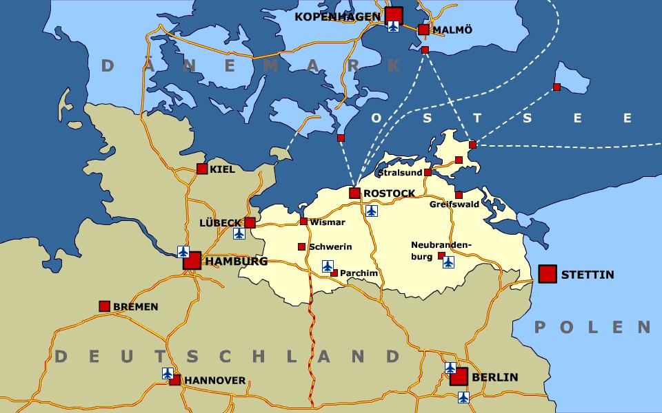
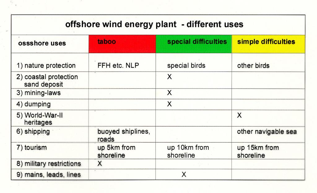
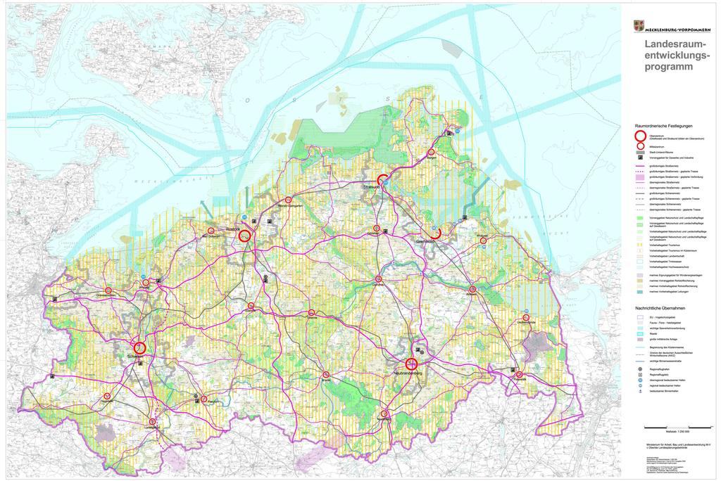
12 Selection criteria for off shore windfarms in MV
13
14

15 Detail: pipeline corridor


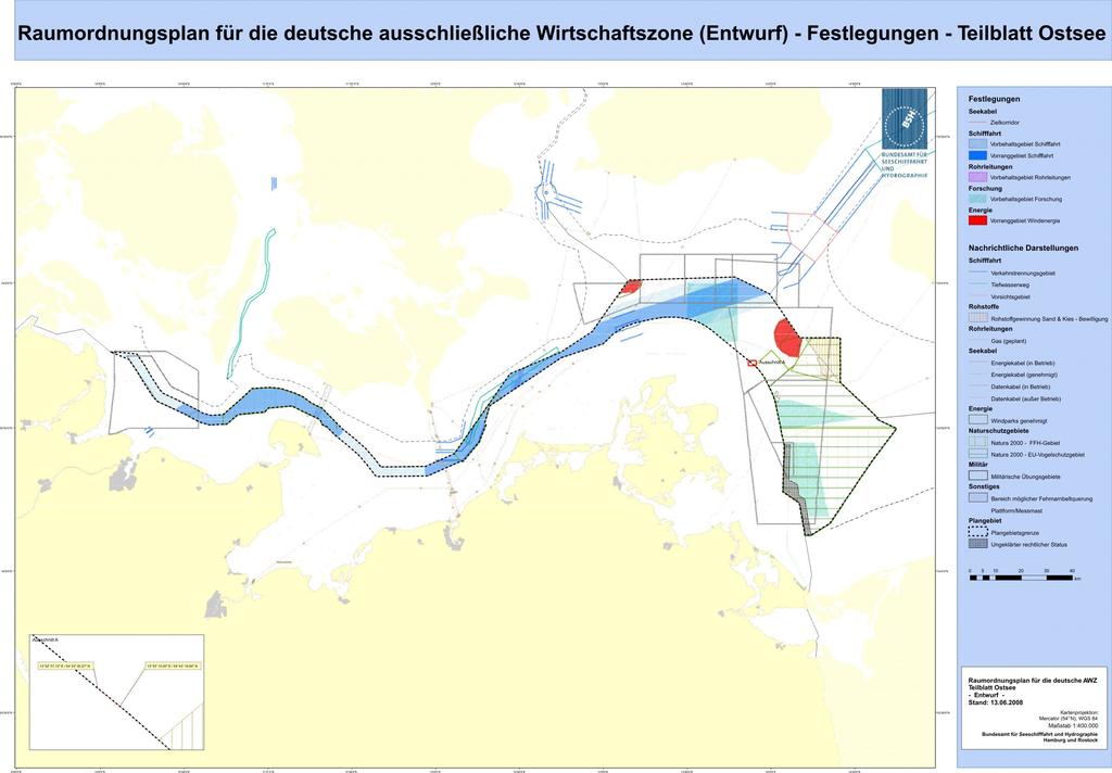
16 Draft Spatial Plan EEZ of Baltic Sea
17 Preparation of the spatial plan Announce planning intention; Enquire about user interests Draw up draft spatial plan Scoping Draw up environmental report Consult on draft spatial plan and environmental report Weigh up all interests amend draft spatial plan if necessary Consult again those stakeholders whose interests are affected by the amendment Final version of the spatial plan with a consolidated environmental statement Spatial plan published as a statutory instrument.
18 Contents 1.) Introduction 2.) Sea borders and sea uses 3.) Maritime Spatial Planning 4.) Territorial Impact Assessment for off shore projects 5.) Conclusions
19 Which role does TIA play? Check large-scale infrastructure projects at an early stage of planning for compliance with the objectives of spatial planning for mutual balance of conflicting objectives for optimum planning solutions
20 Which issues are checked in TIA? In principle: All relevant issues! Bernhard Heinrichs: role of spatial planning in maritime policy
21 TIA, SEA and EIA Environment Spatial Development EIA Environmental Impact Assessment TIA Territorial Impact Assessment project level SEA Strategic Environmental Assessment programme level Bernhard Heinrichs: role of spatial planning in maritime policy

22 Example Windfarm Baltic 1 Main issues : - Collision risk - nature protection - tourism Bernhard Heinrichs: role of spatial planning in maritime policy


23 Windfarm Baltic 1 -Bird migration - Bernhard Heinrichs: role of spatial planning in maritime policy

24 Impact on tourism: spoiled horizon? Bernhard Heinrichs: role of spatial planning in maritime policy
25 What are the benefits of TIA? 1) managing conflicts by early participation of target groups 2) minimizing negative impacts and costs by optimizing the choice for location / routing / technical planning 3) ensuring planning reliability by giving early and reliable information about realisation chances 4) shortening the whole planning process by pre-checking crucial points 5) securing spatial planning objectives by the duty to take TIA results into account in the following process 6) supporting local administrations in case of large-scale investments
26 Conclusion Spatial planning is an indispensable instrument for coordinating activities at sea and in the coastal regions and for sustainable resource management in these areas.

27 Thank you very much for your attention!
Marine Spatial Planning Experience from Mecklenburg-Vorpommern (Germany) By Susan Toben
 By Susan Toben") Marine Spatial Planning Experience from Mecklenburg-Vorpommern (Germany) By Susan Toben Ministry of Transport, Building and Regional Development Mecklenburg Vorpommern PlanCoast Lead Partner Administrative
Marine Spatial Planning Experience from Mecklenburg-Vorpommern (Germany) By Susan Toben Ministry of Transport, Building and Regional Development Mecklenburg Vorpommern PlanCoast Lead Partner Administrative
Offshore Energy and Maritime Spatial Planning in the German EEZ
 Offshore Energy and Maritime Spatial Planning in the German EEZ Bettina Käppeler, BSH Federal Maritime and Hydrographic Agency On Duty for Shipping and Seas German Exclusive Economic Zone EEZ not part
Maritime Spatial Planning in the Baltic Sea Region
 Maritime Spatial Planning in the Baltic Sea Region Talis Linkaits Head of VASAB Secretariat 20 May 2015 Helsinki A cooperation of ministers of the 11 Baltic Sea Region countries responsible for spatial
Marine Spatial Planning in the Baltic Sea Region
 Marine Spatial Planning in the Baltic Sea Region Towards coherence and cross-border solutions in Baltic Maritime Spatial Plans Coordinator & Project manager Dr Ingela Isaksson Swedish Agency for Marine
Maritime Spatial Planning
 Maritime Spatial Planning The Dutch experience Kopenhagen 28 november 2012 Lodewijk.Abspoel@minienm.nl North Sea 2 Outline History of MSP in the Netherlands Spatial Plan for the Dutch EEZ, principles and
SPLAN-Natura Towards an integrated spatial planning approach for Natura th January, 2017 Brussels. Commissioned by DG Environment
 SPLAN-Natura 2000 Towards an integrated spatial planning approach for Natura 2000 Commissioned by DG Environment 17 th January, 2017 Brussels V. Simeonova (Ph.D.) Drivers towards integrating Biodiversity
The Spatial Offshore Grid Plan for the German Exclusive Economic Zone
 11 2 The Spatial Offshore Grid Plan for the German Exclusive Economic Zone Annika Koch 2.1 Legal mandate 12 2.2 Accompanying Strategic Environmental Assessment 12 2.3 Results of the Environmental Report
MSP Process drawings and descriptions
 MSP Process drawings and descriptions 12 December 2016 2 Table of Contents 1. Belgium... 3 2. The Netherlands... 5 3. Germany... 7 4. Denmark... 9 5. Scotland... 11 6. Sweden... 13 7. Norway... 15 1. Belgium
1. Baltic SCOPE Towards coherence and cross-border solutions in Baltic Maritime Spatial Plans
 NSHC 32th Conference Explanatory Note Dublin, Ireland Item E.2 MSP 21-23 June 2016 Germany Cross border MSP for the EEZ, a case study from the Baltic Sea The Federal Maritime and Hydrographic Agency of
Towards coherent maritime spatial planning in the Baltic Sea Region, transnational and project perspective Talis Linkaits Head of VASAB Secretariat
 3 June 2013 Riga PartiSEApate Workshop MSP as Tool for Underwater Cultural Heritage Management in the Baltic Sea Towards coherent maritime spatial planning in the Baltic Sea Region, transnational and project
POLISH LAW ON MSP. Andrzej Cieślak Maritime Office in Gdynia
 POLISH LAW ON MSP Andrzej Cieślak Maritime Office in Gdynia Preconditions Ownership/management of allsea areas (internal sea waters, territorial sea, EEZ): the State, and in its name the Minister responsible
Country Fiche Latvia Updated October 2016
 Country Fiche Latvia Updated October 2016 1. General information Marine area under Latvian jurisdiction includes inland sea waters, Territorial sea (12 nautical miles from the baseline) and exclusive economic
Country Fiche Lithuania
 Country Fiche Lithuania Updated June 2018 1. General information The Lithuanian maritime space is delimited by the Decree of the Government of the Republic of Lithuania of 6 December, 2004, No. 1597 and
Maritime Spatial Planning in the Baltic Sea Region
 Maritime Spatial Planning in the Baltic Sea Region Past, present, perspective Talis Linkaits VASAB Secretariat XIX International Environmental Forum 22 March 2018, Saint Petersburg A cooperation of ministers
Identification of maritime spatial planning best practices in the Baltic Sea Region and other EU maritime regions
 Identification of maritime spatial planning best practices in the Baltic Sea Region and other EU maritime regions PLAN BOTHNIA Baltic Sea Region Stakeholder Meeting Jacek Zaucha, Magdalena Matczak Two
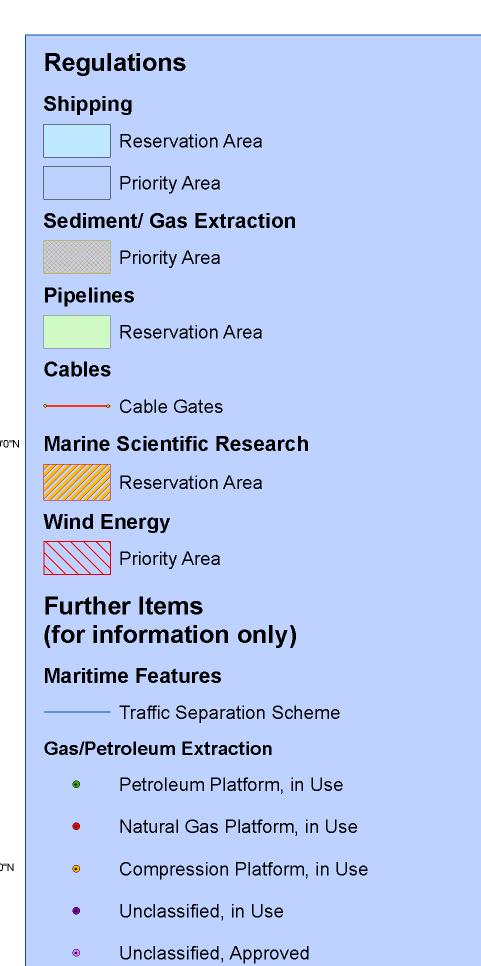
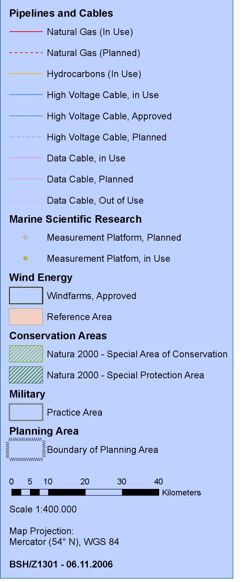
Country Fiche Germany
 Country Fiche Germany Updated April 2017 1. General information Map: German Baltic Sea EEZ and Territorial Sea / Inland Waters Source: Federal Maritime and Hydrographic Agency (BSH) Exclusive Economic
Ecosystem-Based Approach in MSP
 Ecosystem-Based Approach in MSP 16th Meeting of the joint HELCOM-VASAB Maritime Spatial Planning Working Group Ministry of Environment Aleksanterinkatu 7, Helsinki 8.-9. May 2018 Prof. Dr. jur. Gerold
National Perspectives - Portugal. Margarida Almodovar
 National Perspectives - Portugal Margarida Almodovar margarida.almodovar@mam.gov.pt from base line to the external limit of the continental shelf behind 200 miles and according to UNCLOS definitions Economic
Tackling MSP integration challenges in the BSR
 Towards sustainable governance of Baltic marine space 2015 2018 BALTSPACE Towards sustainable governance of Baltic marine space Tackling MSP integration challenges in the BSR Michael Gilek, Södertörn University,
Natura 2000 and spatial planning. Executive summary
 Natura 2000 and spatial planning Executive summary DISCLAIMER The information and views set out in this study are those of the author(s) and do not necessarily reflect the official opinion of the Commission.
EUSAIR on sea topics from Slovenian perspective
 MINISTRY OF FOREIGN AFFAIRS REPUBLIC OF SLOVENIA EUSAIR on sea topics from Slovenian perspective Mag. Andreja Jerina National Coordinator 4 EU MRS: 270 millions of population 19 MS 12 non MS Sea basin
Country Fiche Latvia.
 Country Fiche Latvia 1. General information Marine waters under Latvian jurisdiction include inland sea waters, territorial sea (12 nautical miles from the baseline) and exclusive economic zone (EEZ) waters.
Marine/Maritime Spatial Planning Andrej Abramić
 Marine/Maritime Spatial Planning Andrej Abramić EcoAqua SUMMER SCHOOL: Ecosystem approach to aquaculture 26-29th of October 2015 Research and Technology to enhance excellence in Aquaculture development
This document has been verified by the responsible MSP authority (or representative) of Germany in September 2018.
 of Germany in September 2018.") Contact MSP in general: Federal Ministry of the Interior, Building and Community www.bmi.de EEZ: Ms Dr. Katharina Erdmenger (Ms Vera Moosmayer) Federal Ministry of the Interior, Building and Community,
Contact MSP in general: Federal Ministry of the Interior, Building and Community www.bmi.de EEZ: Ms Dr. Katharina Erdmenger (Ms Vera Moosmayer) Federal Ministry of the Interior, Building and Community,
Country Fiche Sweden Updated May 2018
 Country Fiche Sweden Updated May 2018 1. General information 2 the territorial sea (12-nm zone) 70,000 km2 the Exclusive Economic Zone 60,000 km2 the EEZ is limited to the central line between adjacent
Country Fiche Estonia
 Country Fiche Estonia Deleted: October Updated May 2018 Deleted: 7 1. General information Size of internal waters (to the baseline) and territorial sea (12-nm zone from the baseline) approximately 25 200
Maritime Spatial Planning: Transboundary Cooperation in the Celtic Seas Looking Ahead
 Maritime Spatial Planning: Transboundary Cooperation in the Celtic Seas Looking Ahead Looking ahead MSP in the context of the European Maritime and Fisheries Fund (EMFF) and beyond SIMCelt Final Conference
The INTERREG III B BaltCoast Project A pilot initiative on Integrated Coastal Zone Management in the Baltic Sea ( )
") COASTLINE REPORTS 2005-5 The INTERREG III B BaltCoast Project A pilot initiative on Integrated Coastal Zone Management in the Baltic Sea (2002-2005) Editors: B. Heinrichs, A. Schultz-Zehden & S. Toben
COASTLINE REPORTS 2005-5 The INTERREG III B BaltCoast Project A pilot initiative on Integrated Coastal Zone Management in the Baltic Sea (2002-2005) Editors: B. Heinrichs, A. Schultz-Zehden & S. Toben
Summary Report. 7-8 November, 2013 Sports Complex of the Central Sports Club of the Army, Severnyi mol 7 Baltiysk, Kaliningrad Oblast Region, Russia
 RU LT Transnational stakeholders meeting on the concept for maritime spatial planning in the Lithuanian Sea and its potential impacts on sea use in Russia 7-8 November, 2013 Sports Complex of the Central
Country Fiche Estonia
 Country Fiche Estonia Updated October 2017 1. General information Size of internal waters (to the baseline) and territorial sea (12-nm zone from the baseline) approximately 25 200 km 2. Exclusive economic
Country Fiche Germany
 Country Fiche Germany Updated June 2018 1. General information Map: German Baltic Sea EEZ and Territorial Sea / Inland Waters Source: Federal Maritime and Hydrographic Agency (BSH) Exclusive Economic Zone
ESPON 2020 Cooperation Programme. Anneloes van Noordt MC-member Belgium
 ESPON 2020 Cooperation Programme Anneloes van Noordt MC-member Belgium Anneloes.vannoordt@vlaanderen.be Outline ESPON 2020 Cooperation Programme Applied Research Targeted Analysis Database & Tools Outreach
Findings and recommendations from Central Baltic case
 W 1/1 Recommendations on transboundary planning from Baltic SCOPE Findings and recommendations from Central Baltic case Ingūna Urtāne Director of Spatial Planning Department of the Ministry of Environmental
The Danish Maritime Spatial Data Infrastructure (MSDI) Geodata of the Sea
 Geodata of the Sea") MSDI/MSP The Danish Maritime Spatial Data Infrastructure (MSDI) Geodata of the Sea Components of an infrastructure: DATA - metadata, datasets FUNCTIONALITY - spatial data services, web services and other
MSDI/MSP The Danish Maritime Spatial Data Infrastructure (MSDI) Geodata of the Sea Components of an infrastructure: DATA - metadata, datasets FUNCTIONALITY - spatial data services, web services and other
Croatian physical planning system and strategic approach to MSP
 W 1/7 Past two years all over the Europe: case studies 2 Croatian physical planning system and strategic approach to MSP Vesna Marohnić Kuzmanović Head of Department Croatian Institute for Spatial Development
MARITIME PLANNING IN PORTUGAL
 MARITIME PLANNING IN PORTUGAL Marta Chantal Ribeiro 2 May 2007 In Portugal there is currently no strategic planning system in force for the maritime area as a whole The maritime area under Portuguese jurisdiction
Maritime Spatial Planning in a CCB s context Mikhail Durkin MSP Seminar, 22 November 2016 Riga, Latvia
 Maritime Spatial Planning in a CCB s context Mikhail Durkin MSP Seminar, 22 November 2016 Riga, Latvia co-funded by EU LIFE Programme Maritime Spatial Planning "a public process of analyzing and allocating
MODELS AND TOOLS FOR GOVERNANCE OF
 Working Papers Collection No. 1/2015 MODELS AND TOOLS FOR GOVERNANCE OF THE ADRIATIC AND IONIAN SEAS www.unimc.it/maremap NATIONAL POLITICS AND EU POLITICS: THE MARITIME SPATIAL PLANNING AND INTEGRATED
Environmentally Sound Concepts for Spatial Use in the Baltic Sea Coastal Area of the Russian Federation
 Area of the Russian Federation Recommendations Advisory Assistance Programme for Environmental Protection in the Countries of Central and Eastern Europe, the Caucasus and Central Asia of German Federal
Natura 2000 in the marine environment: state of implementation and next steps
 Life on the blue planet: biodiversity research and the new European marine policies EPBRS European Platform on Biodiversity Research Strategy Porto, Portugal 7-9 November 2007 Natura 2000 in the marine
Mediteranean sea issues in the view of ESPON ESaTDOR project and Marine Spatial Planning in Slovenia
 DIREKTORAT ZA PROSTOR, GRADITEV IN STANOVANJA Mediteranean sea issues in the view of ESPON ESaTDOR project and Marine Spatial Planning in Slovenia BlueMed meeting of stakeholders on a micro-regional level
Marine Spatial Planning as an important tool for implementing the MSFD
 Marine Spatial Planning as an important tool for implementing the MSFD Risto Kalliola Tallinn, Nov. 16 th 2012 DEPARTMENT OF GEOGRAPHY AND GEOLOGY University of Turku, Finland Ten principles to provide
Geological information for Europe : Towards a pan-european Geological Data Infrastructure
 Geological information for Europe : Towards a pan-european Geological Data Infrastructure Integrating geoscientific information for EU competitiveness Co-funded by the European Union European societal
Necessary common minimum requirements for Maritime Spatial Planning (MSP) in the Baltic Sea
 in the Baltic Sea") www.planbothnia.org Co-financed under European Integrated Maritime Policy Necessary common minimum requirements for Maritime Spatial Planning (MSP) in the Baltic Sea Contribution to the PLAN BOTHNIA work
www.planbothnia.org Co-financed under European Integrated Maritime Policy Necessary common minimum requirements for Maritime Spatial Planning (MSP) in the Baltic Sea Contribution to the PLAN BOTHNIA work
This document has been verified by the responsible MSP authority (or representative) of Lithuania on
 of Lithuania on") Contact MSP in general Ms. Algimantė Treinienė Head of Spatial Planning Urban Development and Architecture Division Construction and Territorial Planning Department Ministry of Environment A. Jakšto 4
Contact MSP in general Ms. Algimantė Treinienė Head of Spatial Planning Urban Development and Architecture Division Construction and Territorial Planning Department Ministry of Environment A. Jakšto 4
Management Planning & Implementation of Communication Measures for Terrestrial Natura 2000 Sites in the Maltese Islands Epsilon-Adi Consortium
 Management Planning & Implementation of Communication Measures for Terrestrial Natura 2000 Sites in the Maltese Islands Epsilon-Adi Consortium Briefing Meetings, February 2013 CT3101/2011, MEPA, Malta
Strengthening the cooperation in the region: Carpathian, Tisa,, Danube and Black Sea areas
 Strengthening the cooperation in the region: Carpathian, Tisa,, Danube and Black Sea areas 14th October 2009 SEE Annual Conference Advancing development through transnational cooperation in South East
Policy framework The Netherlands and the Polar Regions, Summary and priorities
 Policy framework The Netherlands and the Polar Regions, 2011-2015 Summary and priorities The policy outlined in this Policy Framework for the Polar Regions (2011-2015) is part of the government s orientation
Introduction to IMP: need and added value
 Introduction to IMP: need and added value Christophe Le Visage Consultant Stratégies Mer et Littoral 1 Summary IMP : Why? The case for integration 1 What is IMP? 2 Content, process IMP: Added Value 3 2
Baltic Sea Region cooperation in Maritime Spatial Planning - HELCOM/VASAB
 Baltic Sea Region cooperation in Maritime Spatial Planning - HELCOM/VASAB Sten Jerdenius Swedish Ministry of the Environment HELCOM/VASAB MSP Group Baltic Sea Region subregional workshop Espoo 31 March
ALASKA DEEP-DRAFT ARCTIC PORT EVALUATION
 ALASKA DEEP-DRAFT ARCTIC PORT EVALUATION Joint Study of Federal and State June 20, 2012 Opportunity and Constraint Warming of Arctic region is leading to new maritime opportunities. Thawing of permafrost
THE ROLE OF SPATIAL PLANNING IN INTEGRATED COASTAL ZONE MANAGEMENT RECOMMENDATIONS FROM THE INTERREG III B BALTCOAST PROJECT
 THE ROLE OF SPATIAL PLANNING IN INTEGRATED COASTAL ZONE MANAGEMENT RECOMMENDATIONS FROM THE INTERREG III B BALTCOAST PROJECT DISCUSSION PAPER FOR THE TRANSNATIONAL WORKING GROUP DECEMBER 2004 CONTENT 1.
The Governance of Land Use
 The planning system Levels of government and their responsibilities The Governance of Land Use Country fact sheet Germany Germany is a federal country with four levels of government. Below the national
Multinational Spatial Planning Experience
 POLAND Multinational Spatial Planning Experience of the Baltic Sea Region Competitiveness and territorial cohesion in Eastern and South-Eastern Europe Magdalena Zagrzejewska-Fiedorowicz VASAB 2010 Visions
MARINE PLANNING IN THE NETHERLANDS
 MARINE PLANNING IN THE NETHERLANDS Hermien Busschbach Ministry of Transport, Public Works and Water Management (DG Water) Bremen, 2 May 2007 Marine Planning in the Netherlands OUTLINE policy context; international
The National Policy Strategy for Infrastructure and Spatial Planning CODE24 CONFERENCE. Emiel Reiding
 The National Policy Strategy for Infrastructure and Spatial Planning Emiel Reiding Structure of presentation 1. Spatial planning in the Netherlands 2. National Policy Strategy Aims National interests 3.
Legal problems of environmental management. Spatial planning and space management. M. Gajewski 2014 / 2015
 Legal problems of environmental management Spatial planning and space management M. Gajewski 2014 / 2015 Course contents (in brief) Constitutional basis of the environment protection system. General principles
ESPON support for Targeted Analyses Ilona Raugze Director
 ESPON support for Targeted Analyses Ilona Raugze Director ESPON EGTC 14 November 2017 ESPON EGTC workshop Targeted Analysis in support of better policy making in cities and regions Inspire policy making
Implementation of the Political Declaration on energy cooperation between the North Seas Countries. Support Group 1 on Maritime Spatial Planning
 Implementation of the Political Declaration on energy cooperation between the North Seas Countries Support Group 1 on Maritime Spatial Planning Work Programme 1. Work area as outlined in Annex I to the
Country reports. Israel did not establish an Exclusive Economic Zone. Consequently, its jurisdiction is restricted to the Israeli territorial waters.
 Country reports I. ISRAEL Disclaimer This document has not been adopted by the European Commission and should therefore not be relied upon as a statement of the European Commission. The purpose of this
Maritime Spatial Planning Framework Directive Supported by INSPIRE
 Maritime Spatial Planning Framework Directive Supported by INSPIRE Andrej Abramić, Vanda Nunes de Lima, Paul Smits, Emanuele Bigagli, Chris Schubert European Commission Joint Research Centre Institute
TEN-T North Sea-Baltic Corridor improvements. Regional Workshop, 13/09/2016, Poznan, Poland
 TEN-T North Sea-Baltic Corridor improvements Regional Workshop, 13/09/2016, Poznan, Poland Contents Introduction to VASAB, NSB CoRe project and WP4 Group of Activities 4.1. Group of Activities 4.2. Structure
Country Fiche Sweden.
 Country Fiche Sweden 1. General information the territorial sea (12- nm zone) 70,000 km2 the Exclusive Economic Zone 60,000 km2 the EEZ is limited to the central line between adjacent states because the
Evaluation of Spatial Planning as a Tool for Integrated Marine Management Status, Obstacles and Research Gaps
 Evaluation of Spatial Planning as a Tool for Integrated Marine Management Status, Obstacles and Research Gaps Baltic MSP Forum Riga 17.-18. June 2014 A. Morf & A. Grimvall: Swedish Institute for the Marine
European Commission. Legal aspects of maritime spatial planning. Summary report
 European Commission SOCIO-ECONOMIC STUDIES IN THE FIELD OF THE INTEGRATED MARITIME POLICY FOR THE EUROPEAN UNION Legal aspects of maritime spatial planning Summary report Socio-economic studies in the
BURGAS CASE STUDY: LAND-SEA INTERACTIONS
 BURGAS CASE STUDY: LAND-SEA INTERACTIONS Dr. Margarita Stancheva IO-BAS, Bulgaria Name of presentation CROSS BORDER MARITIME SPATIAL PLANNING IN THE BLACK SEA ROMANIA AND BULGARIA (MARSPLAN BS) Project
How to integrate maritime cultural heritage into maritime spatial planning?
 2ND SUBMARINER Conference #BetterOff Blue17 Creating synergies for a biobased society How to integrate maritime cultural heritage into maritime spatial planning? Susanne Altvater, s.pro 28.09.2017 #BetterOffBlue17
BURGAS CASE STUDY: LAND-SEA INTERACTIONS. Dr. Margarita Stancheva
 BURGAS CASE STUDY: LAND-SEA INTERACTIONS Dr. Margarita Stancheva Name of presentation NEED FOR COHERENCE BETWEEN LAND AND SEA ACTIVITIES Name presenter Burgas is the fourth largest city in Bulgaria and
Implementation of the ESPON 2020 cooperation program. 16 January 2017 Anneloes van Noordt
 Implementation of the ESPON 2020 cooperation program 16 January 2017 Anneloes van Noordt Outline! ESPON Cooperation Program! Specific Objectives! Applied Research! Targeted Analysis! Database & Tools!
PartiSEApate Conference
 Baltic Maritime Spatial Planning Forum PartiSEApate Conference C r e a t i n g c o m m o n u n d e r s t a n d i n g B a l t i c M a r i t i m e S p a t i a l P l a n n i n g F o r u m B a l t i c M a
Marine Spatial Planning in Hellas; Recent Facts and Perspectives
 XXV FIG CONGRESS Engaging the Challenges, Enhancing the Relevance Kuala Lumpur, Malaysia 16 21 June 2014 Marine Spatial Planning in Hellas; Recent Facts and Perspectives Mrs. Chaiditsa BOLANOU Surveying
HELSINKI COMMISSION Baltic Marine Environment Protection Commission
 HELSINKI COMMISSION Baltic Marine Environment Protection Commission HELCOM RECOMMENDATION 24/10 Adopted 25 June 2003, having regard to Article 20, Paragraph 1 b) of the 1992 Helsinki Convention IMPLEMENTATION
DELIVERING ECOSYSTEM- BASED MARINE SPATIAL PLANNING IN PRACTICE
 DELIVERING ECOSYSTEM- BASED MARINE SPATIAL PLANNING IN PRACTICE A first assessment for the UK and Ireland January 08 GLOBAL WARMING IMAGES / WWF ABOUT WWF WWF is the world s leading independent conservation
SWEDISH SDI DEVELOPMENT & IMPLEMENTATION OF INSPIRE
 SWEDISH SDI DEVELOPMENT & IMPLEMENTATION OF INSPIRE Christina Wasström, Lantmäteriet, 801 82 Gävle, Sweden, christina.wasstrom@lm.se ABSTRACT The Swedish Government and Parliament has given Lantmäteriet
The Swedish National Geodata Strategy and the Geodata Project
 The Swedish National Geodata Strategy and the Geodata Project Ewa Rannestig, Head of NSDI Co-ordination Unit, Lantmäteriet, ewa.rannstig@lm.se Ulf Sandgren, Project Manager Geodata Project, Lantmäteriet,
Margarita Stancheva Hristo Stanchev & Robert Young 2. MEDCOAST JUBILEE WORKSHOP May 2015, Iberotel Sarigerme Park, Dalaman, Turkey
 Margarita Stancheva Hristo Stanchev & Robert Young 2 INTRODUCTION: Bulgarian Black Sea coast INTRODUCTION: Increasing pressure on Bulgarian coastal zone In 2011, of the 7 364 570 people that lived in Bulgaria,
Dorset MSP Evidence Base 18 th February Ness Smith C-SCOPE Project Officer
 Dorset MSP Evidence Base 18 th February 2011 Ness Smith C-SCOPE Project Officer Sectoral Topic Papers MMA Description document gives an overview of the area, it s physical and human influences 20 Topic
W 2/3 Integration in Baltic Sea MSP: What role does it really play? Introduction. Michael Gilek Luttmann. Södertörn University.
 W 2/3 Integration in Baltic Sea MSP: What role does it really play? Introduction Michael Gilek Luttmann Södertörn University #BalticMSP Providing science-based approaches and tools to clarify and improve
by Jacek Zaucha and Magdalena Matczak Maritime Institute in Gdańsk
 Identification of maritime spatial planning best practices in the Baltic Sea Region and other European Union maritime regions (comments of WWF, Estonia, Latvia, Germany. HELCOM Secretariat accomodated,finland
Building the Sustainable Network of Settlements on the Caspian Sea Region of Kazakhstan
 Building the Sustainable Network of Settlements on the Caspian Sea Region of Kazakhstan Introduction The Ecological Zoning and Identification of Ecological Capacity of Natural and Socio- Economic Potential
Marine Spatial Planning (MSP): A practical approach to ecosystembased
: A practical approach to ecosystembased") Marine Spatial Planning (MSP): A practical approach to ecosystembased management Erik Olsen, Institute of Marine Research, Norway Fanny Douvere, International Oceanographic Commission Overview Why we need
Marine Spatial Planning (MSP): A practical approach to ecosystembased management Erik Olsen, Institute of Marine Research, Norway Fanny Douvere, International Oceanographic Commission Overview Why we need
Iceland and the Arctic: The Politics of Territoriality. Valur Ingimundaron Professor of Contemporary History, University of Iceland
 Iceland and the Arctic: The Politics of Territoriality Valur Ingimundaron Professor of Contemporary History, University of Iceland Drivers of Icelandic Arctic Policies Geostrategic Position Economic Interests
International Guidelines on Access to Basic Services for All
 International Guidelines on Access to Basic Services for All Presentation and initials lessons from implementation Accessibility to services in regions and cities : measures and policies, OECD 18 June
National Land Use Policy and National Integrated Planning Framework for Land Resource Development
 Title National Land Use Policy and National Integrated Planning Framework for Land Resource Development Duration: 32 Weeks Objective: Adoption of appropriate land use planning approaches to: Maintain the
ACRONYMS AREAS COUNTRIES MARINE TERMS
 Natura 2000 ACRONYMS AREAS COUNTRIES MARINE TERMS DEFINITION A European network of protected sites under the European Habitats and Birds Directives, aiming to protect the most valuable and threatened European
World Oceans Day 2010 Our oceans: opportunities and challenges
 World Oceans Day 2010 Our oceans: opportunities and challenges Roundtable discussion on the United Nations Convention on the Law of the Sea fifteen years after its entry into force HOW EFFECTIVELY IS UNCLOS
Information System as a Tool for Marine Spatial Planning The SmartSea Vision and a Prototype
 Information System as a Tool for Marine Spatial Planning The SmartSea Vision and a Prototype Ari Jolma Marine Research Centre Finnish Environment Institute May 10, 2017 ISESS 2017, Zadar, Croatia Contents
Cross-border Maritime Spatial Plan for the Black sea - Romania and Bulgaria project
 Cross-border Maritime Spatial Plan for the Black sea - Romania and Bulgaria project in Romania and Bulgaria Plan Presentation A first step in the management of the marine areas of Romania and Bulgaria
Russia region - Overview on chemical control legislation (labelling, MSDS, existing and new substances, etc) and aspects of GHS
 and aspects of GHS") Russia region - Overview on chemical control legislation (labelling, MSDS, existing and new substances, etc) and aspects of GHS Mrs. Elena Zbitneva, Dr. Dmitry Skobelev CISCENTER e.zbitneva@ciscenter.ru
Russia region - Overview on chemical control legislation (labelling, MSDS, existing and new substances, etc) and aspects of GHS Mrs. Elena Zbitneva, Dr. Dmitry Skobelev CISCENTER e.zbitneva@ciscenter.ru
MyCoast Elaboration of a vision and a strategy for Integrated Coastal Zone Management in Bulgaria
 1. NAME MyCoast Elaboration of a vision and a strategy for Integrated Coastal Zone Management in Bulgaria 2. DESCRIPTION 2.1 The case Bulgaria s coastal territory is distributed among three administrative
The Development of Trade Transit Corridors in Africa s Landlocked Countries
 The Development of Trade Transit Corridors in Africa s Landlocked Countries I. Introduction Africa has 15 landlocked countries that face specific challenges. Botswana, Burkina Faso, Burundi, Chad, Central
Key Indicators for Territorial Cohesion & Spatial Planning Stakeholder Workshop - Project Update. 13 th December 2012 San Sebastián, Basque Country
 Key Indicators for Territorial Cohesion & Spatial Planning Stakeholder Workshop - Project Update 13 th December 2012 San Sebastián, Basque Country Key Aims Explore the use of territorial data in developing
International Guidelines for Ecosystem-based, Marine Spatial Management
 International Guidelines for Ecosystem-based, Marine Spatial Management Charles Ehler and Fanny Douvere, Consultants Intergovernmental Oceanographic Commission and Man and the Biosphere Programme UNESCO
Antarctic Tourism What Next? Key Issues to Address with Binding Rules
 Agenda Item: CEP 6b, ATCM 10 Presented by: Original: ASOC English Antarctic Tourism What Next? Key Issues to Address with Binding Rules 1 Summary This paper addresses three issues we have identified as
INSPIRE Monitoring and Reporting Implementing Rule Draft v2.1
 INSPIRE Infrastructure for Spatial Information in Europe INSPIRE Monitoring and Reporting Implementing Rule Draft v2.1 Title INSPIRE Monitoring and Reporting Implementing Rule v2.1 Creator DT Monitoring
Mediterranean Sea and Territorial Development, Opportunities and Risks
 EESC Hearing Towards an EU Macro-Regional Strategy for the Mediterranean Mediterranean Sea and Territorial Development, Opportunities and Risks Michaela Gensheimer Structure of Intervention Part I: What
Status & Challengers of Cook Islands GEO DRM. Cook Islands GEO S/GIS History
 Status & Challengers of Cook Islands GEO DRM By Patrick A. ARIOKA Planning & Advisory Officer EMERGENCY MANAGEMENT COOK ISLANDS Cook Islands GEO S/GIS History 1990 NZODA/MFAT trained by Landcare Research
ADRIPLAN: an EU funded pilot project on MSP in the Adriatic Ionian Region Pierpaolo Campostrini CORILA and CNR-ISMAR
 ADRIPLAN: an EU funded pilot project on MSP in the Adriatic Ionian Region Pierpaolo Campostrini CORILA and CNR-ISMAR ADRiatic Ionian maritime spatial PLANning ADRIPLAN PROJECT ADRIPLAN has the objective
PROTOCOL ON THE IMPLEMENTATION OF THE ALPINE CONVENTION OF 1991 RELATING TO SPATIAL PLANNING AND SUSTAINABLE DEVELOPMENT
 PROTOCOL ON THE IMPLEMENTATION OF THE ALPINE CONVENTION OF 1991 RELATING TO SPATIAL PLANNING AND SUSTAINABLE DEVELOPMENT SPATIAL PLANNING AND SUSTAINABLE DEVELOPMENT" PROTOCOL Preamble The Republic of
The Baltic Sea Region Maritime Spatial Planning Data Expert Sub-group. First Report 2015/2016/
 The Baltic Sea Region Maritime Spatial Planning Data Expert Sub-group First Report 2015/2016/2017 21.04.2017. Contents 1. Glossary 2 2. Introduction. 3 3. MSP Data. 5 3.1. Input Data. 5 3.2 Output Data.