DBCP National Report Germany. 28 th DBCP Fremantle, 6 st of October 2012 Kai Herklotz (BSH)
|
|
|
- Damian Bradford
- 6 years ago
- Views:
Transcription

1 DBCP National Report Germany 28 th DBCP Fremantle, 6 st of October 2012 Kai Herklotz (BSH)
2 Outline BSH and its relation to the DBCP ARGO-Program Other activities MARNET Perspectives th DBCP, Fremantle ; National Report 2

3 BSH th DBCP, Fremantle ; National Report 3
4 BSH Federal Maritime an Hydrographic Agency (former DHI) Our tasks as an provider of maritime services in Germany include: Maritime security Hydrographic surveying, wreck search Nautical information systems Warning services (water level forecasts and tide predictions, storm surge warning service, ice service) Monitoring of the sea (with regard to climate changes and environmental status) Maritime geospatial data center Maritime spatial planning in the German Exclusive Economic Zone (EEZ) Planning approval procedures for offshore wind farms and pipelines provide competent information about the status of the North Sea and the Baltic Sea and ensure the continuity of measurements th DBCP, Fremantle ; National Report 4


5 Sea Area Exchange with NE-Atlantic, Norwegian Coastal Current, Fair Isle Current, etc Precipitation, Evaporation Heat Exchange with Atmosphere Solar Radiation, Wind Forcing, etc Baltic Outflow N River Runoff Exchange with English Channel th DBCP, Fremantle ; National Report 5

6 ARGO Floats 173 Floats Budget for 50 new floats p.a th DBCP, Fremantle ; National Report 6

 Water masses in the Nordic Seas (Greenland Sea,")
7 AWI (Alfred-Wegner-Institut for Polar Research) Studies about variability and long-term changes in warm deep water in the Weddell Gyre. Monitors of convection events. ZMAW (University of Hamburg) Water masses in the Nordic Seas (Greenland Sea, Norwegian Sea, Iceland Sea, Lofoten Basin) th DBCP, Fremantle ; National Report 7


, Oxygen data (1 depth):")

8 Iridium data based telemetry in the Central Irminger Sea Small surface element Installed in Aug Transfer Iridium SMS messaging (Provider: CLS, France) T, C, P (10 depth), Oxygen data (1 depth): every 4h GPS position & Batt. Voltage: every 2h Contact: jkarstensen@ifm geomar.de
 06.10.")
9 Gliders Leibniz-Institut für Meeresforschung Kiel, GEOMAR (former IFM GEOMAR) HZG Helmholtz-Zentrum für Küstenforschung Geesthacht (former GKSS) th DBCP, Fremantle ; National Report 9


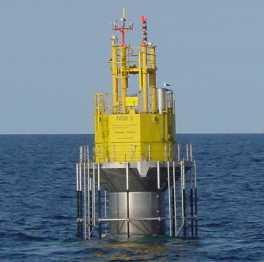


10 MARNET - Marine Environmental Network th DBCP, Fremantle ; National Report 10
11 Tasks of the Marine Monitoring Basic information about local met-ocean conditions Long-term observation of main met-ocean parameters Monitoring of changes of marine climate Support of marine services (i.e. sea ice service, water level and storm surge forecast service ) Support of operational models Calibration of remote sensing data Basics for the Offshore-Industry th DBCP, Fremantle ; National Report 11


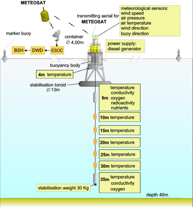
12 Station concept / measurement concept th DBCP, Fremantle ; National Report 12


13 Station concept / measurement concept Meteorological System central unit (MILOS) sensors (wind, temperature, humidity, pressure) add.sensors (sunshine, view) NMEA Source (position, motion) DCP (satellite communication) th DBCP, Fremantle ; National Report 13

 No transmission costs")
 Data flow: METEOSAT DWD")

14 Station concept / measurement concept Data Transmission Two transmissions per hour (1 x Meteo, 1 x Ozeano., optional. + 6 x Storm) No transmission costs Quality: 91,7% i.d. (Jan 11) Data flow: METEOSAT DWD Offenbach GTS BSH / DWD EUMETSAT Darmstadt BSH Hamburg th DBCP, Fremantle ; National Report 14


15 MARNET - Boundary Conditions th DBCP, Fremantle ; National Report 15

")


16 MARNET - Stations North Sea Buoys (NSB) NSB-2 NSB th DBCP, Fremantle ; National Report 16

17 Unmaned Lightship German Bight and GW Ems
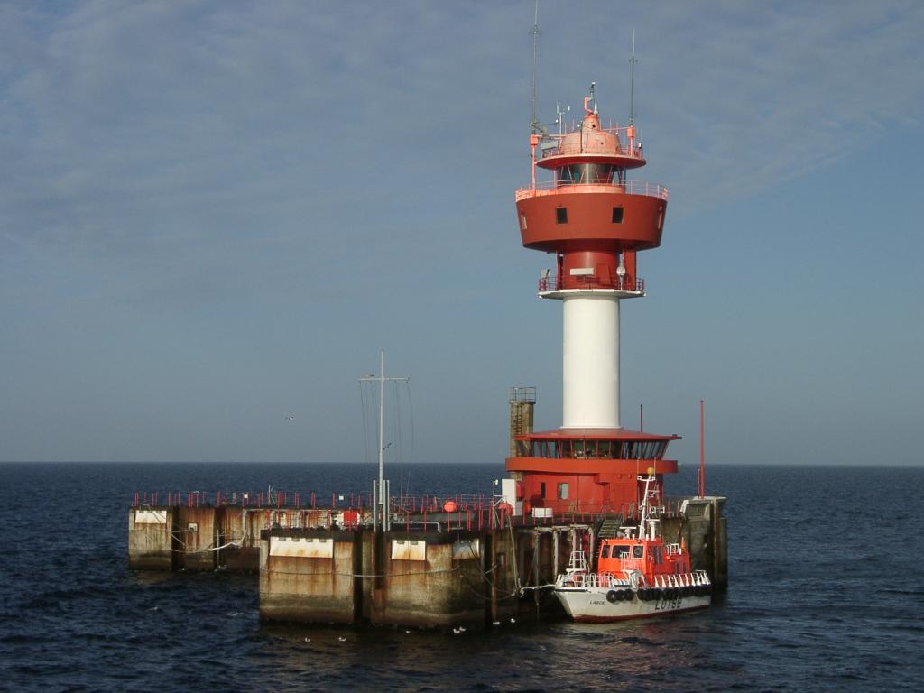
18 Lighthouse Kiel


19 Oder Bank Buoy FEHMARN BELT Buoy

20 Darsser Mast Arkona Becken


21 FINO: Research Platforms in the North- and Baltic Sea FINO 3 FINO th DBCP, Fremantle ; National Report FINO 21 2
22 Offshore-Platform FINO 1 general information: database: fino.bsh.de th DBCP, Fremantle ; National Report 22

23 MARNET - wave measurements FINO 3 0, th DBCP, Fremantle ; National Report 23


24 MARNET - wave measurements Instrumentation Buoy AWAC X-Band marine radar Radar gauges Wave camera th DBCP, Fremantle ; National Report 24

25 MARNET - wave measurements 20 FINO 1 Storm Event 01. Nov Wave Height [m] th DBCP, Fremantle ; National Report 25 32,5 32,0 31,5 Water Level [m] Hs arithm. mean 1.7 Pegel 31,0 30,5 30,0 29,5 29,0 28,5
26 Perspectives Priority on reduction of budget and stuff Development of a new monitoring concept Optimisation of the measurement system Intensification of see state analyses Intensification of current analyses Implementation of other parameters (e.g. PH) th DBCP, Fremantle ; National Report 29


27 Thanks for your attention! th DBCP, Fremantle ; National Report 30
LOG_aLevel. Tsunami Warning System
 LOG_aLevel Tsunami Warning System General Acoustics e.k. Am Kiel-Kanal 1 24106 Kiel Germany Phone: +49 431 5 80 81 80 www.generalacoustics.com Info@generalacoustics.com LOG_aLevel Tsunami Warning System
FINO Technical and Environmental Research Platforms for the Benefit of the Offshore Industry
 FINO Technical and Environmental Research Platforms for the Benefit of the Offshore Industry Andreas Beeken & Detlef Kindler, 2011-09-07 BALTEXPO, Gdansk 2011 Project Overview FINO Forschung in Nord- und
Tsunami detection component: discussion about the existing network and real-time data processing. Begoña Pérez Gómez, Puertos del Estado, Spain
 Tsunami detection component: discussion about the existing network and real-time data processing Begoña Pérez Gómez, Puertos del Estado, Spain Outline Marine network: role within TWS s NEAMTWS overview
Potential impact of offshore wind farms on water renewal in the Baltic Sea
 Potential impact of offshore wind farms on water renewal in the Baltic Sea Hans Burchard hans.burchard@io-warnemuende.de Baltic Sea Research Institute Warnemünde, Germany Summer School, AWI-GKSS-IOW, Büsum,
SAWS: Met-Ocean Data & Infrastructure in Support of Industry, Research & Public Good. South Africa-Norway Science Week, 2016
 SAWS: Met-Ocean Data & Infrastructure in Support of Industry, Research & Public Good South Africa-Norway Science Week, 2016 Marc de Vos, November 2016 South Africa: Context http://learn.mindset.co.za/sites/default/files/resourcelib/e
Development and applications of regional reanalyses for Europe and Germany based on DWD s NWP models: Status and outlook
 Development and applications of regional reanalyses for Europe and Germany based on DWD s NWP models: Status and outlook Frank Kaspar 1, Michael Borsche 1, Natacha Fery 1, Andrea K. Kaiser-Weiss 1, Jan
1. Baltic SCOPE Towards coherence and cross-border solutions in Baltic Maritime Spatial Plans
 NSHC 32th Conference Explanatory Note Dublin, Ireland Item E.2 MSP 21-23 June 2016 Germany Cross border MSP for the EEZ, a case study from the Baltic Sea The Federal Maritime and Hydrographic Agency of
Figure 1: The operational wave monitoring system at the gauge Lighthouse Alte Weser.
 Results of operational sea-wave monitoring with radar gauges Sebastian Rütten, Stephan Mai, Jens Wilhelmi, Theodor Zenz, Hartmut Hein, Ulrich Barjenbruch (all: German Federal Institute of Hydrology (BfG),
M1:Estimating past and recent extreme wave and surge conditions in the southwestern Baltic Sea
 1st International Workshop on Waves, Storm Surges, and Coastal Hazards M1:Estimating past and recent extreme wave and surge conditions in the southwestern Baltic Sea Nikolaus Groll, Lidia Gaslikova and
EUMETSAT SAF NETWORK. Lothar Schüller, EUMETSAT SAF Network Manager
 1 EUMETSAT SAF NETWORK Lothar Schüller, EUMETSAT SAF Network Manager EUMETSAT ground segment overview METEOSAT JASON-2 INITIAL JOINT POLAR SYSTEM METOP NOAA SATELLITES CONTROL AND DATA ACQUISITION FLIGHT
New perspectives of climate change impacts on marine anthropogenic radioactivity in Arctic regions
 New perspectives of climate change impacts on marine anthropogenic radioactivity in Arctic regions M. Karcher 1,3, I. Harms 2, R. Gerdes 3, W.J.F. Standring 4, M. Dowdall 4, P. Strand 4 1 O.A.Sys Ocean
NOAA/OAR Observing Systems
 NOAA/OAR Observing Systems Dr. Christopher L. Sabine Director NOAA s Pacific Marine Environmental Laboratory Workshop on Hydroclimate Monitoring Systems and Measurement Needs June, 2014 Global Ocean Observing
Climate change and its impact on regional seas: What do we know? Marine weather and its impact
 Climate change and its impact on regional seas: What do we know? Marine weather and its impact Hans von Storch Institute for Coastal Research GKSS Research Center, Germany Berlin, PlanCoast Meeting, 21.
MANAGEMENT OF THE NIEMEN RIVER BASIN WITH ACCOUNT OF ADAPTATION TO CLIMATE CHANGE. Hydro-meteorological Monitoring System
 MANAGEMENT OF THE NIEMEN RIVER BASIN WITH ACCOUNT OF ADAPTATION TO CLIMATE CHANGE Hydro-meteorological Monitoring System Draft Interim Report Milestone 1 Giovanni Crema 18 October 2012 Scope of work assessment
HY-2A Satellite User s Guide
 National Satellite Ocean Application Service 2013-5-16 Document Change Record Revision Date Changed Pages/Paragraphs Edit Description i Contents 1 Introduction to HY-2 Satellite... 1 2 HY-2 satellite data
2 nd Cryonet-Asia Worskshop Salekhard, Russian Federation (2-5 February 2016)
") WMO 2 nd Cryonet-Asia Worskshop Salekhard, Russian Federation (2-5 February 2016) WMO Rolling Review of Requirements (RRR) Etienne Charpentier Chief, WMO Observing Systems Division WMO; Name of Department
WMO 2 nd Cryonet-Asia Worskshop Salekhard, Russian Federation (2-5 February 2016) WMO Rolling Review of Requirements (RRR) Etienne Charpentier Chief, WMO Observing Systems Division WMO; Name of Department
Oceans and Climate. Caroline Katsman. KNMI Global Climate Division
 Oceans and Climate Caroline Katsman KNMI Global Climate Division Aimée Slangen, Roderik van de Wal (IMAU, Utrecht University) Sybren Drijfhout, Wilco Hazeleger (KNMI, Global Climate) Bert Vermeersen (NIOZ/Delft
The Delaware Environmental Monitoring & Analysis Center
 The Delaware Environmental Monitoring & Analysis Center Tina Callahan Delaware Estuary Science & Environmental Summit 2013 January 27-30, 2013 What is DEMAC? Delaware Environmental Monitoring & Analysis
EUMETSAT SAF NETWORK. Lothar Schüller, EUMETSAT SAF Network Manager
 1 EUMETSAT SAF NETWORK Lothar Schüller, EUMETSAT SAF Network Manager EUMETSAT ground segment overview METEOSAT JASON-2 INITIAL JOINT POLAR SYSTEM METOP NOAA SATELLITES CONTROL AND DATA ACQUISITION FLIGHT
ESURFMAR Report to DBCP
 ESURFMAR Report to DBCP by Jean Rolland, Pierre Blouch, Michel Trémant DBCP 23 -Jeju 15-19 October ESURFMAR E-SURFMAR is an optional programme of the ground based EUMETNET Composite Observing System (EUCOS)
Add NOAA nowcoast Layers to Maps
 WebEOC Maps Add-on Quick Reference Guide Add NOAA nowcoast Layers to Maps Overview With Maps Add-on, you can configure an unlimited number of map layers. These layers allow you to control the data you
DBCP 2012 SCIENTIFIC AND TECHNICAL WORKSHOP Fremantle, Australia, 2 October 2012 SALIENT FEATURES OF INDIAN DEEP SEA INSTRUMENTED BUOY NETWORK IN THE
 DBCP 2012 SCIENTIFIC AND TECHNICAL WORKSHOP Fremantle, Australia, 2 October 2012 SALIENT FEATURES OF INDIAN DEEP SEA INSTRUMENTED BUOY NETWORK IN THE BAY OF BENGAL R. Venkatesan, Arul Muthiah, Simi Mathew
Report on Activities for NOOS 2011
 Report on Activities for NOOS 2011 Contact Henning Wehde, Chairman of NOOS, henning.wehde@imr.no NOOS members and change in membership Belgium Royal Belgian Institute for Natural Sciences, Management Unit
PS4a: Real-time modelling platforms during SOP/EOP
 PS4a: Real-time modelling platforms during SOP/EOP Mistral Tramontane Bora Etesian Major sites of dense water formation Major sites of deep water formation influence of coastal waters Chairs: G. Boni,
FRontiers in Arctic marine Monitoring: The FRAM Ocean Observing System
 FRontiers in Arctic marine Monitoring: The FRAM Ocean Observing System Thomas Soltwedel Alfred-Wegener-Institute Helmholtz-Center for Polar and Marine Research Arctic Frontiers 2017 Svalbard Symposium
JCOMM Overview. Val Swail Environment and Climate Change Canada JCOMM representative to IOGP Metocean Committee
 JCOMM Overview Val Swail Environment and Climate Change Canada JCOMM representative to IOGP Metocean Committee IOGP/JCOMM/WCRP Workshop Our Future Climate Understanding the spread of physical risk for
Offshore Energy and Maritime Spatial Planning in the German EEZ
 Offshore Energy and Maritime Spatial Planning in the German EEZ Bettina Käppeler, BSH Federal Maritime and Hydrographic Agency On Duty for Shipping and Seas German Exclusive Economic Zone EEZ not part
Floats in the Seasonal ice zone
 Floats in the Seasonal ice zone Co-ordinator: Institut Français de Recherche pour l'exploitation de la Mer - France Potential for a task team has discussed at AST-15 Colleagues have been approached and
The future role of statistical post-processing in weather forecasting. Klaus Knüpffer Philip Lorenz
 The future role of statistical post-processing in weather forecasting Klaus Knüpffer Philip Lorenz 31.10.2014 Outline 1 2 3 4 MOS technology Interpolation in space Future 2 1 MOS technology 3 1 MOS technology
Storm surge forecasting and other Met Office ocean modelling
 Storm surge forecasting and other Met Office ocean modelling EMODnet stakeholder meeting Clare O Neill + many others Outline Ocean modelling at the Met Office Storm surge forecasting Current operational
Emerging Needs, Challenges and Response Strategy
 Emerging Needs, Challenges and Response Strategy Development of Integrated Observing Systems in China JIAO Meiyan Deputy Administrator China Meteorological Administration September 2011 Geneva Outline
Global Ocean Freshwater Flux Components from Satellite, Re-analysis and In-Situ Climatologies
 Global Ocean Freshwater Flux Components from Satellite, Re-analysis and In-Situ Climatologies Axel Andersson1, Christian Klepp2, Stephan Bakan1, Karsten Fennig3, Jörg Schulz4 1 Max-Planck-Institut für
CHAPTER 13 WEATHER ANALYSIS AND FORECASTING MULTIPLE CHOICE QUESTIONS
 CHAPTER 13 WEATHER ANALYSIS AND FORECASTING MULTIPLE CHOICE QUESTIONS 1. The atmosphere is a continuous fluid that envelops the globe, so that weather observation, analysis, and forecasting require international
Forecast of Nearshore Wave Parameters Using MIKE-21 Spectral Wave Model
 Forecast of Nearshore Wave Parameters Using MIKE-21 Spectral Wave Model Felix Jose 1 and Gregory W. Stone 2 1 Coastal Studies Institute, Louisiana State University, Baton Rouge, LA 70803 2 Coastal Studies
Natura 2000 in the marine environment: state of implementation and next steps
 Life on the blue planet: biodiversity research and the new European marine policies EPBRS European Platform on Biodiversity Research Strategy Porto, Portugal 7-9 November 2007 Natura 2000 in the marine
Quality assurance for sensors at the Deutscher Wetterdienst (DWD)
") Quality assurance for sensors at the Deutscher Wetterdienst (DWD) Quality assurance / maintenance / calibration Holger Dörschel, Dr Tilman Holfelder WMO International Conference on Automatic Weather Stations
Quality assurance for sensors at the Deutscher Wetterdienst (DWD) Quality assurance / maintenance / calibration Holger Dörschel, Dr Tilman Holfelder WMO International Conference on Automatic Weather Stations
Status after Six Years
 German-Indonesian Tsunami Early Warning System () Status after Six Years Joern Lauterjung and the -Team Challenge Indonesia Short Early Warning Time Tsunamis are generated at the trench (orange line) Traveltimes
Monitoring the coastal ocean: from local to regional
 Monitoring the coastal ocean: from local to regional Luísa Bastos University of Porto / CIIMAR RAIA partners Ocean monitoring To answer key societal and scientific challenges navigation safety, fisheries,
CGMS Baseline In response to CGMS action/recommendation A45.01 HLPP reference: 1.1.8
 Prepared by WGIII Agenda Item: 7.1 Discussed in WGIII CGMS Baseline In response to CGMS action/recommendation A45.01 HLPP reference: 1.1.8 In CGMS-45, Working Group III agreed to hold a review of the CGMS
New JCOMM series replaces discontinued MMROA series JOINT WMO/IOC TECHNICAL COMMISSION FOR OCEANOGRAPHY AND MARINE METEOROLOGY TECHNICAL REPORT SERIES
 New JCOMM series replaces discontinued MMROA series JOINT WMO/IOC TECHNICAL COMMISSION FOR OCEANOGRAPHY AND MARINE METEOROLOGY TECHNICAL REPORT SERIES No. Title WMO/TD-No. Issued 41 SOT Annual report for
Overview of data assimilation in oceanography or how best to initialize the ocean?
 Overview of data assimilation in oceanography or how best to initialize the ocean? T. Janjic Alfred Wegener Institute for Polar and Marine Research Bremerhaven, Germany Outline Ocean observing system Ocean
Development of Innovative Technology to Provide Low-Cost Surface Atmospheric Observations in Data-sparse Regions
 Development of Innovative Technology to Provide Low-Cost Surface Atmospheric Observations in Data-sparse Regions Paul Kucera and Martin Steinson University Corporation for Atmospheric Research/COMET 3D-Printed
SOP/EOP Implementation Plan -Overview for the Eastern Mediterranean Target Area Emmanouil Anagnostou
 SOP/EOP Implementation Plan -Overview for the Eastern Mediterranean Target Area Emmanouil Anagnostou University of Connecticut & Hellenic Center for Marine Research Contributions from Efrat Morin The Hebrew
For Military, Research, Tactical Portable Vehicle Mount Fixed Base
 For Military, Research, Military & Commercial Weather Applications Stations Tactical Portable Vehicle Mount Fixed Base WEATHERPAK Marine Weather Stations for Harsh Environments WEATHERPAK marine weather
Government of Sultanate of Oman Public Authority of Civil Aviation Directorate General of Meteorology. National Report To
 Government of Sultanate of Oman Public Authority of Civil Aviation Directorate General of Meteorology National Report To Panel on Tropical Cyclones in the Bay of Bengal And Arabian Sea 43rd Session, India
FOURTH INTERNATIONAL PORT METEOROLOGICAL OFFICERS WORKSHOP AND SUPPORT TO GLOBAL OCEAN OBSERVATIONS USING SHIP LOGISTICS
 FOURTH INTERNATIONAL PORT METEOROLOGICAL OFFICERS WORKSHOP AND SUPPORT TO GLOBAL OCEAN OBSERVATIONS USING SHIP LOGISTICS PMO-IV 8-10 DEC 2010, ORLANDO, FLORIDA, USA 1 This presentation is generally for
Australian National Report to DBCP. DBCP October, 2014 Weihai, China
 Australian National Report to DBCP DBCP-30 27-31 October, 2014 Weihai, China Outline Australian Bureau of Meteorology (ABOM) Drifting Buoys Background & Planning 2013/14 Deployments & Current Status 2014/15
MERSEA Marine Environment and Security for the European Area
 MERSEA Marine Environment and Security for the European Area Development of a European system for operational monitoring and forecasting of the ocean physics, biogeochemistry, and ecosystems, on global
Response of water temperature to surface wave effects: experiments with the coupled NEMO-WAM
 Response of water temperature to surface wave effects: experiments with the coupled NEMO-WAM Victor Alari (HZG), Joanna Staneva (HZG), Sebastian Grayek (HZG) and Oyvind Breivik (ECMWF/Norwegian Met. Institute)
PREDICTION OF OIL SPILL TRAJECTORY WITH THE MMD-JMA OIL SPILL MODEL
 PREDICTION OF OIL SPILL TRAJECTORY WITH THE MMD-JMA OIL SPILL MODEL Project Background Information MUHAMMAD HELMI ABDULLAH MALAYSIAN METEOROLOGICAL DEPARTMENT(MMD) MINISTRY OF SCIENCE, TECHNOLOGY AND INNOVATION
OSI SAF Sea Ice products
 OSI SAF Sea Ice products Lars-Anders Brevik, Gorm Dybkjær, Steinar Eastwood, Øystein Godøy, Mari Anne Killie, Thomas Lavergne, Rasmus Tonboe, Signe Aaboe Norwegian Meteorological Institute Danish Meteorological
THE CLIMATE INFORMATION MODULE
 Climate Information and Prediction Services (CLIPS) -Curriculum- THE CLIMATE INFORMATION MODULE designed by Dipl.-Met. Peer Hechler Deutscher Wetterdienst P.O. Box 10 04 65 63004 Offenbach Germany THE
2) What general circulation wind belt is the place of origin for hurricanes? A) westerlies B) trade winds C) doldrums D) horse latitudes
 What general circulation wind belt is the place of origin for hurricanes? A) westerlies B) trade winds C) doldrums D) horse latitudes") Meteo 1010 Homework 6 1) What is the difference between a typhoon and a hurricane? A) A hurricane is a true tropical cyclone, but a typhoon is not. B) A hurricane is stronger than a typhoon. C) They represent
Meteo 1010 Homework 6 1) What is the difference between a typhoon and a hurricane? A) A hurricane is a true tropical cyclone, but a typhoon is not. B) A hurricane is stronger than a typhoon. C) They represent
OCN/ATM/ESS 587. Ocean circulation, dynamics and thermodynamics.
 OCN/ATM/ESS 587 Ocean circulation, dynamics and thermodynamics. Equation of state for seawater General T/S properties of the upper ocean Heat balance of the upper ocean Upper ocean circulation Deep circulation
Wave modelling for the German Bight coastalocean predicting system
 Journal of Physics: Conference Series PAPER OPEN ACCESS Wave modelling for the German Bight coastalocean predicting system To cite this article: J Staneva et al 2015 J. Phys.: Conf. Ser. 633 012117 Recent
E-SURFMAR Report. Jean ROLLAND Michel TREMANT Pierre BLOUCH Jon TURTON
 E-SURFMAR Report Jean ROLLAND Michel TREMANT Pierre BLOUCH Jon TURTON DBCP 28-Fremantle 2nd-6th October 2012 E-SURFMAR EUMETNET Members 29 European Meteorological Services. Austria, Belgium, Croatia, Cyprus,
Climate Change in Newfoundland & Labrador
 Climate Change in Newfoundland & Labrador Impacts and Adaptation Newleef Conference 08 October 2015 Met-Ocean Services The Team 55 personnel; 24/7 operational weather forecast desk; Equipment technician
IMPORTANCE OF SATELLITE DATA (FOR REANALYSIS AND BEYOND) Jörg Schulz EUMETSAT
 Jörg Schulz EUMETSAT") IMPORTANCE OF SATELLITE DATA (FOR REANALYSIS AND BEYOND) Jörg Schulz EUMETSAT Why satellite data for climate monitoring? Global coverage Global consistency, sometimes also temporal consistency High spatial
IMPORTANCE OF SATELLITE DATA (FOR REANALYSIS AND BEYOND) Jörg Schulz EUMETSAT Why satellite data for climate monitoring? Global coverage Global consistency, sometimes also temporal consistency High spatial
Specifications for a Reference Radiosonde for the GCOS Reference. Upper-Air Network (GRUAN)
") Specifications for a Reference Radiosonde for the GCOS Reference Upper-Air Network (GRUAN) By the Working Group on Atmospheric Reference Observations (WG-ARO) Final Version, October 2008 1. Introduction
Specifications for a Reference Radiosonde for the GCOS Reference Upper-Air Network (GRUAN) By the Working Group on Atmospheric Reference Observations (WG-ARO) Final Version, October 2008 1. Introduction
Tr a n s r e g i o n a l C o l l a b o r a t i v e Re s e a r c h C e n t r e TR 172
 Tr a n s r e g i o n a l C o l l a b o r a t i v e Re s e a r c h C e n t r e TR 172 ArctiC Amplification: Climate Relevant Atmospheric and SurfaCe Processes, and Feedback Mechanisms (AC) 3 Towards a better
The IHPT Marine Spatial Data infrastructure and its contribution to the INSPIRE Directive
 The IHPT Marine Spatial Data infrastructure and its contribution to the INSPIRE Directive INSPIRE - GWF 2015 - Coastal & Marine session Lisbon Congress Center, Portugal - Thursday, 28 May 2015 Summary
Accuracy comparison of mesoscale model simulated offshore wind speeds between Japanese and German coastal waters
 Accuracy comparison of mesoscale model simulated offshore wind speeds between Japanese and German coastal waters Teruo Ohsawa 1), Fuko Okayama 1), Takeshi Misaki 1)*, Susumu Shimada 2), Koji Kawaguchi
Chapter 12: Meteorology
 Chapter 12: Meteorology Section 1: The Causes of Weather 1. Compare and contrast weather and climate. 2. Analyze how imbalances in the heating of Earth s surface create weather. 3. Describe how and where
THE PORTUGUESE INSTITUTE FOR THE OCEAN AND ATMOSPHERE. Pedro Viterbo
 THE PORTUGUESE INSTITUTE FOR THE OCEAN AND ATMOSPHERE Pedro Viterbo pedro.viterbo@ipma.pt 2012 IPMA CREATION Before Now IM INRB/IPIMAR LNEG IPMA SOME NUMBERS: 506 Staff: Personnel 426 Budget 2014 11% 26%
Progress on GCOS-China CMA IOS Development Plan ( ) PEI, Chong Department of Integrated Observation of CMA 09/25/2017 Hangzhou, China
 PEI, Chong Department of Integrated Observation of CMA 09/25/2017 Hangzhou, China") Progress on GCOS-China CMA IOS Development Plan (2016-2020) PEI, Chong Department of Integrated Observation of CMA 09/25/2017 Hangzhou, China 1. Progress on GCOS-China 1 Organized GCOS-China GCOS-China
Progress on GCOS-China CMA IOS Development Plan (2016-2020) PEI, Chong Department of Integrated Observation of CMA 09/25/2017 Hangzhou, China 1. Progress on GCOS-China 1 Organized GCOS-China GCOS-China
METOC at Defence Center for Operational Oceanography (FCOO)
") METOC at Defence Center for Operational Oceanography (FCOO) Forsvarets Center for Operativ Oceanografi Dr. Johan Söderqvist Oceanographer jos@fcoo.dk FCOO Staff (13 pos.) Geophysical expertise: oceanography,
METOC at Defence Center for Operational Oceanography (FCOO) Forsvarets Center for Operativ Oceanografi Dr. Johan Söderqvist Oceanographer jos@fcoo.dk FCOO Staff (13 pos.) Geophysical expertise: oceanography,
11/19/14. Chapter 11: Hurricanes. The Atmosphere: An Introduction to Meteorology, 12 th. Lutgens Tarbuck
 Chapter 11: Hurricanes The Atmosphere: An Introduction to Meteorology, 12 th Lutgens Tarbuck Lectures by: Heather Gallacher, Cleveland State University! Hurricanes: " Hurricanes are intense centers of
E-SURFMAR Report. Jean ROLLAND Gilbert EMZIVAT Pierre BLOUCH Jon TURTON
 E-SURFMAR Report Jean ROLLAND Gilbert EMZIVAT Pierre BLOUCH Jon TURTON DBCP 30 WEIHAI 27-31 October 2014 E-SURFMAR EUMETNET members 31 European Meteorological Services. Austria, Belgium, Croatia, Cyprus,
Frequency and evolution of Low Level Jet events over the Southern North Sea analysed from WRF simulations and LiDAR measurements
 Frequency and evolution of Low Level Jet events over the Southern North Sea analysed from WRF simulations and LiDAR measurements David Wagner1, Gerald Steinfeld1, Björn Witha1, Hauke Wurps1, Joachim Reuder2
CGMS Baseline. Sustained contributions to the Global Observing System. Endorsed by CGMS-46 in Bengaluru, June 2018
 CGMS Baseline Sustained contributions to the Global Observing System Best Practices for Achieving User Readiness for New Meteorological Satellites Endorsed by CGMS-46 in Bengaluru, June 2018 CGMS/DOC/18/1028862,
networks from ISPRA GABRIELE NARDONE, MAURO BENCIVENGA, GIOVANNI ARENA
 The Italian observational networks from ISPRA retemareografica@isprambiente.itit reteondametrica@isprambiente.it GABRIELE NARDONE, MAURO BENCIVENGA, GIOVANNI ARENA ISPRA - RMN Italian Tide Gauge Network
National Polish services using regional products
 Oceanographic services for the European regions - session organized by EuroGOOS European Maritime Day, Gdańsk, 20th May 2011 Polish Baltic Frédéric Chopin Philharmonic, Chamber Green Hall National Polish
The Arctic Sea Ice Cover
 The Arctic Sea Ice Cover From the Living Earth Interface, Impediment, Integrator Frozen ocean 8-15 million km 2 Size of U.S. Meters thick Floating, moving ice Highly variable Large albedo Climate change!
Current Hydrographic Projects at BSH
 7 th Workshop Seabed Acoustics, Rostock, November 19/20, 2015 P01-1 Current Hydrographic Projects at BSH Thomas Dehling Federal Maritime and Hydrographic Agency (BSH) Germany Contact Address Website BSH
Understanding oceans in change: Engineering science and technological tools for distributed real-time sensing Kristin Guldbrandsen Frøysa, CMR and
 Understanding oceans in change: Engineering science and technological tools for distributed real-time sensing Kristin Guldbrandsen Frøysa, CMR and University of Bergen Anne A Hageberg, CMR Christian Michelsen
Integrating Hydrologic and Storm Surge Models for Improved Flood Warning
 Integ Hydrologic and Storm Surge Models for Improved Flood Warning Leahy, C.P, Entel, M, Sooriyakumaran, S, and Warren, G Flood Warning Program Office, Bureau of Meteorology, Docklands, Victoria National
MOSAiC Science Implementation The Multidisciplinary drifting Observatory for the Study of Arctic Climate
 MOSAiC Science Implementation The Multidisciplinary drifting Observatory for the Study of Arctic Climate MOSAiC Coordination Team M. Shupe. 13 March 2016 MOSAiC Plan Drifting, interdisciplinary process
Wind Resource Assessment Practical Guidance for Developing A Successful Wind Project
 December 11, 2012 Wind Resource Assessment Practical Guidance for Developing A Successful Wind Project Michael C Brower, PhD Chief Technical Officer Presented at: What We Do AWS Truepower partners with
1. Greenland Flow Distortion experiment (GFDex)
") 1. Greenland Flow Distortion experiment (GFDex) (GFDex) is an international fieldwork and modelling-based project to investigate the role that Greenland plays in distorting atmospheric flow over and around
1. Greenland Flow Distortion experiment (GFDex) (GFDex) is an international fieldwork and modelling-based project to investigate the role that Greenland plays in distorting atmospheric flow over and around
Sea ice forecasting for optimised Arctic ship routing. Björn Hendrik Fock*
 Sea ice forecasting for optimised Arctic ship routing Björn Hendrik Fock* YOPP-UK, Exeter, 09 Nov 2015 * Previously Sea at ice University forecasting of for Hamburg, ship routing now at Met Office bjoern.fock@metoffice.gov.uk
Earth Observation in coastal zone MetOcean design criteria
 ESA Oil & Gas Workshop 2010 Earth Observation in coastal zone MetOcean design criteria Cees de Valk BMT ARGOSS Wind, wave and current design criteria geophysical process uncertainty modelling assumptions
NOOS EuroGOOS Annual meeting
 NOOS EuroGOOS Annual meeting 22.-23.11.2012 Hamburg Henning Wehde NOOS Chair NOOS objectives Co-ordinate, improve and harmonize the development of operational marine data and information services Provide
"Outcomes of the storm surge and waves workshop in Dominican Republic and the questionnaire"
 "Outcomes of the storm surge and waves workshop in Dominican Republic and the questionnaire" Strengthening Regional Cooperation to Support Forecasting with Multi Hazard Approach in RA IV Ritz Carlton Grand
Oceanology International, London, March 2012 Ocean Observation & Forecasting programme. An African Network of Offshore Real-Time Metocean Stations
 Oceanology International, London, March 2012 Ocean Observation & Forecasting programme An African Network of Offshore Real-Time Metocean Stations Valérie QUINIOU-RAMUS, Rémi ESTIVAL (TOTAL S.A., EP/DEV/TEC/GEO)
Lecture 5: Precipitation
 Lecture 5: Precipitation Key Questions 1. What physical concepts control the formation of precipitation (air pressure, expanding gases and cooling, and vapor pressure)? 2. What are some air mass lifting
Leibniz Institute for Baltic Sea Research Warnemünde
 Leibniz Institute for Baltic Sea Research Warnemünde FS Alkor Monitoring cruise Cruise- No. Al 43a 4 th February 14 th February 214 Kiel Bight to northern Gotland Sea This report is based on preliminary
Tackling MSP integration challenges in the BSR
 Towards sustainable governance of Baltic marine space 2015 2018 BALTSPACE Towards sustainable governance of Baltic marine space Tackling MSP integration challenges in the BSR Michael Gilek, Södertörn University,
Deutscher Wetterdienst. German Climate Services - A contribution to the Global Framework for Climate Services (GFCS) Tobias Fuchs and Paul Becker
 Tobias Fuchs and Paul Becker") Deutscher Wetterdienst German Climate Services - A contribution to the Global Framework for Climate Services (GFCS) Tobias Fuchs and Paul Becker Deutscher Wetterdienst (DWD) Business Area Climate and Environment
Deutscher Wetterdienst German Climate Services - A contribution to the Global Framework for Climate Services (GFCS) Tobias Fuchs and Paul Becker Deutscher Wetterdienst (DWD) Business Area Climate and Environment
NATIONAL REPORT OF POLAND
 NATIONAL REPORT OF Executive summary This report summarizes activities of the Hydrographic Office/Service in the field of hydrography since the previous Baltic Sea Hydrographic Commission 18th Conference
Improving global coastal inundation forecasting WMO Panel, UR2014, London, 2 July 2014
 Improving global coastal inundation forecasting WMO Panel, UR2014, London, 2 July 2014 Cyclone Sidr, November 2007 Hurricane Katrina, 2005 Prof. Kevin Horsburgh Head of marine physics, UK National Oceanography
New JCOMM series replaces discontinued MMROA series JOINT WMO/IOC TECHNICAL COMMISSION FOR OCEANOGRAPHY AND MARINE METEOROLOGY TECHNICAL REPORT SERIES
 New JCOMM series replaces discontinued MMROA series JOINT WMO/IOC TECHNICAL COMMISSION FOR OCEANOGRAPHY AND MARINE METEOROLOGY TECHNICAL REPORT SERIES No. Title WMO/TD-No. Issued 47 JCOMM Technical Workshop
The Mediterranean Operational Oceanography Network (MOON): Products and Services
: Products and Services") The Mediterranean Operational Oceanography Network (MOON): Products and Services The MOON consortia And Nadia Pinardi Co-chair of MOON Istituto Nazionale di Geofisica e Vulcanologia Department of Environmental
The Mediterranean Operational Oceanography Network (MOON): Products and Services The MOON consortia And Nadia Pinardi Co-chair of MOON Istituto Nazionale di Geofisica e Vulcanologia Department of Environmental
Long Term Autonomous Ocean Remote Sensing Utilizing the Wave Glider
 Long Term Autonomous Ocean Remote Sensing Utilizing the Wave Glider J. Griffith, K. VanderLugt, Matt Cosad Liquid Robotics 1329 Moffett Park Drive Sunnyvale, CA 94089 Abstract Rising costs of ship time
THAILAND NATIONAL REPORT
 NIOHC18 TH National Report THAILAND NATIONAL REPORT 18 th NORTH INDIAN OCEAN HYDROGRAPHIC COMMISSION (NIOHC) CONFERENCE Goa, India 9 th 12 th April 2018-1 - CONTENTS 1. Hydrographic Office / Service 3
DBCP GTS STATUS AND HIGHLIGHTS (2010)
") 1. Present status of buoy platforms DBCP GTS STATUS AND HIGHLIGHTS (2010) 1.1 For drifting buoys, there was a peak of over 1600 operational buoys on the GTS this June and a peak in the number of Barometer
1. Present status of buoy platforms DBCP GTS STATUS AND HIGHLIGHTS (2010) 1.1 For drifting buoys, there was a peak of over 1600 operational buoys on the GTS this June and a peak in the number of Barometer
JCOMM-CHy Coastal Inundation Forecasting Demonstration Project (CIFDP)
") WMO World Meteorological Organization Working together in weather, climate and water JCOMM-CHy Coastal Inundation Forecasting Demonstration Project (CIFDP) Coastal Flooding & Vulnerable Populations Coastal
WMO World Meteorological Organization Working together in weather, climate and water JCOMM-CHy Coastal Inundation Forecasting Demonstration Project (CIFDP) Coastal Flooding & Vulnerable Populations Coastal
CGSN Overview. GSN Sites CSN Sites Shore Facilities
 GSN Sites CSN Sites Shore Facilities CGSN Overview Coastal Pioneer Array Endurance Array Global Irminger Sea Southern Ocean Station Papa Fixed assets Surface mooring Subsurface mooring Mobile assets Ocean
Semi-enclosed seas. Estuaries are only a particular type of semi-enclosed seas which are influenced by tides and rivers
 Semi-enclosed seas Estuaries are only a particular type of semi-enclosed seas which are influenced by tides and rivers Other semi-enclosed seas vary from each other, mostly by topography: Separated from
Nerushev A.F., Barkhatov A.E. Research and Production Association "Typhoon" 4 Pobedy Street, , Obninsk, Kaluga Region, Russia.
 DETERMINATION OF ATMOSPHERIC CHARACTERISTICS IN THE ZONE OF ACTION OF EXTRA-TROPICAL CYCLONE XYNTHIA (FEBRUARY 2010) INFERRED FROM SATELLITE MEASUREMENT DATA Nerushev A.F., Barkhatov A.E. Research and