Modeling global, urban, and rural exposure to climate-related hazards
|
|
|
- Vernon Paul
- 5 years ago
- Views:
Transcription
1 Modeling global, urban, and rural exposure to climate-related hazards Elizabeth Christenson, Mark Elliott, Ovik Banerjee, Laura Hamrick, Jamie Bartram University of North Carolina Chapel Hill ESRI User Conference - July 15,

2 2
3 Objectives 1. Estimate and rank relative population exposure of countries to the climate-related hazard events of cyclone, drought, and flood Relative Population Exposure: the likelihood that a person in a location would be exposed to a given hazard event in a given period of time 2. Differentiate urban and rural areas 3. Automate global, urban, and rural exposure estimates using ArcGIS Model Builder 3
4 CHRR Global Cyclone Frequency and Distribution 4 Source: Center for Hazards and Risk Research (CHRR)
5 CHRR Global Drought Frequency and Distribution 5 Source: Center for Hazards and Risk Research (CHRR)
6 CHRR Global Flood Frequency and Distribution 6 Source: Center for Hazards and Risk Research (CHRR)


7 LandScan 2008 Global Population Density 7 Source:

8 8 Model Builder: Country-level data

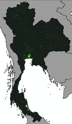
9 9 CHRR Data - Thailand

10 LandScan Data - Thailand Ancillary data used: Administrative boundaries Census Information Land cover Elevation, slope Roads Satellite imagery 10


11 Urban Greater access to health care Reliance on cash income Congested evacuation routes Rural Increased community/social structure and network Decreased access to services, the market, transportation Reliance on subsistence agriculture 11 Sources: Baud, I. et al. Mapping urban poverty for local governance in an Indian mega-city: The case of Delhi. Urban Studies, 2008 Cutter, S.L et al. Social vulnerability to environmental hazards. Soc. Sci. Quart Ruel, M.T. et al. The food, fuel, and financial crises affect the urban and rural poor disproportionately: A review of the evidence. J. Nutr


12 LandScan Threshold Differentiating Urban-Rural Remote Sensing Methods Night-time lights Land cover Satellite imagery Ground Input Methods Census information Modeled population MODIS Afripop Threshold GlobCover E-geopolis 12 Source: Christenson et al. Examining the influence of urban definition when assessing relative safety of drinking-water in Nigeria. Science of the Total Environment, 2014.
13 Differentiating Urban-Rural LandScan Threshold Ground Input Methods Census information Modeled population Strengths Afripop Threshold Allows degrees of urban-ness to be calculated Incorporates multiple facets of urban definition Built infrastructure, population size/density Weaknesses Dependent on input population dataset Spatial resolution Modeled population method 13 Source: Christenson et al. Examining the influence of urban definition when assessing relative safety of drinking-water in Nigeria. Science of the Total Environment, 2014.
14 Defining a Population Threshold United Nations World Urbanization Prospects country-specific estimates for proportion rural Thailand Example: UN estimated proportion: 66% Rural Total LandScan population = 78,668,490 % Rural = (VVVVVVVVVV CCCCCCCCCC) TTTTTTTTTT PPPPPPPPPPPPPPPPPPPP Vary LandScan population density threshold until % Rural matches the UN estimated proportion 14

15 Population Density (VALUE) Range: 0 5 Population Threshold: 0.2 % Rural Sorted population density values 15

16 Population Density (VALUE) Range: 0 38 Population Threshold: 5% Rural 16

17 Population Density (VALUE) Range: 0 60 Population Threshold: 10% Rural 17
 Range: 0")

18 Population Density (VALUE) Range: Population Threshold: 30% Rural 18
 Range: 0")

19 Population Density (VALUE) Range: Population Threshold: 66% Rural 19

20 Model Builder: Raster Reclassification Python script identifies each country s population density threshold and creates Reclass Table Model Builder: Iterative Reclass by Table 20

21 Urban-Rural Reclassification Reclass Table Rural Urban 21

22 Cell Exposure Calculation CCCCCCCC EEEEEEEEEEEEEEEE HHHHHHHHHHHH = PPPPPPPPPPPPPPPPPPPP cccccccc HH HHHHHHHHHHHH,cccccccc H is the hazard event likelihood Cyclone Exposure Drought Exposure Flood Exposure 22
23 Urban, Rural, or Country Exposure AAAAAAAAAAAAAA PPPPPPPPPPPPPPPPPPPP EEEEEEEEEEEEEEEE AAAAAAAA = PPPPPPPPPPPPPPPPPPPP cccccccc HH HHHHHHHHHHHH,cccccccc PPPPPP AAAAAAAA = CCCCCCCC EEEEEEEEEEEEEEEE AAAAAAAA PPPPPP AAAAAAAA Area - Urban, Rural, or Entire Country 23

24 24 Model Builder: Urban, Rural Exposure

25 Urban, Rural Exposure CHRR Drought 25
26 Urban, Rural Drought (CHRR) Urban Rural 26
27 Average Urban Population Exposure to Drought Selected Urban Area x PPPPPPPPPPPPPPPPPPPP cccccccc HH DDDDDDDDDDDDDD,cccccccc Total Urban Population 27


28 Average Rural Population Exposure to Drought Selected Rural Area x PPPPPPPPPPPPPPPPPPPP cccccccc HH DDDDDDDDDDDDDD,cccccccc Total Rural Population 28
29 Average Country Population Exposure to Drought Selected Urban Area Selected Rural Area x + x PPPPPPPPPPPPPPPPPPPP cccccccc HH DDDDDDDDDDDDDD,cccccccc PPPPPPPPPPPPPPPPPPPP cccccccc HH DDDDDDDDDDDDDD,cccccccc Total Thailand Population 29
30 30 Average Cyclone Population Exposure

31 31 Average Drought Population Exposure
32 32 Average Flood Population Exposure
33 Limitations Hazard data is dependent on reported hazards Relative hazard frequency limited by ~20 year recording period Population data is modeled and uncertainty is dependent on resolution and age of census data Urban-rural binary definition 33
34 Next Steps Apply climate-related average population exposure results to specific vulnerabilities such as loss of drinking water Downscaling country-level exposure to regional models Use higher resolution hazard data to validate whether differences in urban and rural exposure hold true at different spatial scales Urban-Rural gradient; identification of slums 34
35 35 References Baud, I.; Sridharan, N.; Pfeffer, K. Mapping urban poverty for local governance in an indian mega-city: The case of Delhi. Urban Studies 2008, 45, Bright, E.A.; Coleman, P.R.; King, A.L.; Rose, A.N.; Urban, M.L. LandScan 2008; Oak Ridge National Laboratory: Oak Ridge, TN, USA, Center for Hazards and Risks Research (CHRR)/Columbia University Center for International Earth Science Information Network (CIESIN)/Columbia University and International Research Institute for Climate and Society (IRI)/Columbia University. Global Cyclone, Drought, Flood Hazard Frequency and Distribution Christenson, E.; Bain, R.; Wright, J.; Aondoakaa, S.; Hossain, R.; Bartram, J. Examining the influence of urban definition when assessing relative safety of drinking-water in Nigeria. Science of the Total Environment 2014, 490, Christenson, E.; Elliott, M.; Banerjee, O.; Hamrick, L.; Bartram, J. Climate-Related Hazards: A Method for Global Assessment of Urban and Rural Population Exposure to Cyclones, Droughts, and Floods. Int. J. Environ. Res. Public Health 2014, 11, Cutter, S.L.; Boruff, B.J.; Shirley, W.L. Social vulnerability to environmental hazards. Soc. Sci. Quart. 2003, 84, Ruel, M.T.; Garrett, J.L.; Hawkes, C.; Cohen, M.J. The food, fuel, and financial crises affect the urban and rural poor disproportionately: A review of the evidence. J. Nutr. 2010, 140, World Urbanization Prospects The 2011 Revision; United Nations Department of Economic and Social Affairs Population Division: New York, NY, USA, 2012; p. 18.

36 Thank you Elizabeth Christenson Questions? 36
37 Global Urban, Rural Average Exposure 40% higher global average exposure to cyclones for urban compared to rural Cities and cyclones on coastlines 34% lower global average exposure to droughts for urban compared to rural No difference in global average exposure to flood Many causes of floods (river vs. storm surge vs. snowmelt) 37
Climate-Related Hazards: A Method for Global Assessment of Urban and Rural Population Exposure to Cyclones, Droughts, and Floods
 Int. J. Environ. Res. Public Health 2014, 11, 2169-2192; doi:10.3390/ijerph110202169 OPEN ACCESS Article International Journal of Environmental Research and Public Health ISSN 1660-4601 www.mdpi.com/journal/ijerph
LandScan Global Population Database
 LandScan Global Population Database The World s Finest Population Distribution Data Uncommon information. Extraordinary places. LandScan Global Population Database East View Cartographic is now offering
Advanced Image Analysis in Disaster Response
 Advanced Image Analysis in Disaster Response Creating Geographic Knowledge Thomas Harris ITT The information contained in this document pertains to software products and services that are subject to the
Städte im Klimawandel...
 10.000 Städte im Klimawandel... Was wissen wir dank GIS? Steffen Kriewald 19. November 2014 Global Urbanization: 75% 50% WUP 14 Cities are most responsible for Climate Change... Climate Change highly threatens
Globally Estimating the Population Characteristics of Small Geographic Areas. Tom Fitzwater
 Globally Estimating the Population Characteristics of Small Geographic Areas Tom Fitzwater U.S. Census Bureau Population Division What we know 2 Where do people live? Difficult to measure and quantify.
Urban Spatial Scenario Design Modelling (USSDM) in Dar es Salaam: Background Information
 in Dar es Salaam: Background Information") Urban Spatial Scenario Design Modelling (USSDM) in Dar es Salaam: Background Information Modelling urban settlement dynamics in Dar es Salaam Revision: 2 (July 2013) Prepared by: Katja Buchta TUM team
Urban Spatial Scenario Design Modelling (USSDM) in Dar es Salaam: Background Information Modelling urban settlement dynamics in Dar es Salaam Revision: 2 (July 2013) Prepared by: Katja Buchta TUM team
ANALYSING THE DIVERSITY OF DEPRIVED AREAS IN MUMBAI, INDIA
 ANALYSING THE DIVERSITY OF DEPRIVED AREAS IN MUMBAI, INDIA MONIKA KUFFER (M.KUFFER@UTWENTE.NL) KARIN PFEFFER, RICHARD SLIUZAS, ISA BAUD, MARTIN VAN MAARSEVEEN Source: Google Earth CONTENT OF PRESENTATION
Measuring Disaster Risk for Urban areas in Asia-Pacific
 Measuring Disaster Risk for Urban areas in Asia-Pacific Acknowledgement: Trevor Clifford, Intl Consultant 1 SDG 11 Make cities and human settlements inclusive, safe, resilient and sustainable 11.1: By
Copernicus Overview. Major Emergency Management Conference Athlone 2017
 Copernicus Overview Major Emergency Management Conference Athlone 2017 Copernicus is a European programme implemented by the European Commission. The services address six thematic areas: land, marine,
Jim Fox. copyright UNC Asheville's NEMAC
 Decisions and System Thinking Jim Fox November, 2012 1 UNC Asheville s s NEMAC National Environmental Modeling and Analysis Center Applied Research and technology development on integration of environmental
GIS in Weather and Society
 GIS in Weather and Society Olga Wilhelmi Institute for the Study of Society and Environment National Center for Atmospheric Research WAS*IS November 8, 2005 Boulder, Colorado Presentation Outline GIS basic
Geospatial Technologies for Resources Planning & Management
 Geospatial Technologies for Resources Planning & Management Lal Samarakoon, PhD Director, Geoinformatics Center Asian Institute of Technology, Thailand Content Geoinformatics for SDG Information Integration
Land Accounts - The Canadian Experience
 Land Accounts - The Canadian Experience Development of a Geospatial database to measure the effect of human activity on the environment Who is doing Land Accounts Statistics Canada (national) Component
Identifying Global Natural Disaster Hotspots
 Identifying Global Natural Disaster Hotspots Gregory Yetman and Robert S. Chen Center for International Earth Science Information Network (CIESIN), Columbia University Abstract The World Bank and Columbia
Use of Geospatial data for disaster managements
 Use of Geospatial data for disaster managements Source: http://alertsystemsgroup.com Instructor : Professor Dr. Yuji Murayama Teaching Assistant : Manjula Ranagalage What is GIS? A powerful set of tools
The UN-GGIM: Europe core data initiative to encourage Geographic information supporting Sustainable Development Goals Dominique Laurent, France
 INSPIRE conference Strasbourg 6 September 2017 The UN-GGIM: Europe core data initiative to encourage Geographic information supporting Sustainable Development Goals Dominique Laurent, France Introduction
Foundation Geospatial Information to serve National and Global Priorities
 Foundation Geospatial Information to serve National and Global Priorities Greg Scott Inter-Regional Advisor Global Geospatial Information Management United Nations Statistics Division UN-GGIM: A global
Climate Change Vulnerability Assessment in Thailand. Kampanart PiyathamrongchaI Naresuan University
 Climate Change Vulnerability Assessment in Thailand Kampanart PiyathamrongchaI Naresuan University Outline Background Objectives Concept and technique to assess climate change vulnerability Discussion
GIS (GEOGRAPHICAL INFORMATION SYSTEMS) AS A FACILITATION TOOL FOR SUSTAINABLE DEVELOPMENT IN AFRICA
 AS A FACILITATION TOOL FOR SUSTAINABLE DEVELOPMENT IN AFRICA") GIS (GEOGRAPHICAL INFORMATION SYSTEMS) AS A FACILITATION TOOL FOR SUSTAINABLE DEVELOPMENT IN AFRICA a presentation by Elizabeth Hicken GDEST Conference on Geospatial Sciences for Sustainable Development
GIS (GEOGRAPHICAL INFORMATION SYSTEMS) AS A FACILITATION TOOL FOR SUSTAINABLE DEVELOPMENT IN AFRICA a presentation by Elizabeth Hicken GDEST Conference on Geospatial Sciences for Sustainable Development
Candidate Name Centre Number Candidate Number CHANGING PHYSICAL AND HUMAN LANDSCAPES SAMPLE ASSESSMENT MATERIALS
 GCSE GEOGRAPHY Sample Assessment Materials 5 Candidate Name Centre Number Candidate Number 0 GCSE GEOGRAPHY UNIT 1 CHANGING PHYSICAL AND HUMAN LANDSCAPES SAMPLE ASSESSMENT MATERIALS 1 hour 30 minutes Section
ENV208/ENV508 Applied GIS. Week 1: What is GIS?
 ENV208/ENV508 Applied GIS Week 1: What is GIS? 1 WHAT IS GIS? A GIS integrates hardware, software, and data for capturing, managing, analyzing, and displaying all forms of geographically referenced information.
Assessing the Regional Vulnerability of Large Scale Mining in Ghana: An Application of Multi Criteria Analysis
 Assessing the Regional Vulnerability of Large Scale Mining in Ghana: An Application of Multi Criteria Analysis Mukesh Subedee, GISDE 14 Arun Poojary, ES&P 13 Clark University April 29, 2013 Ghana: A case
Spatial Analysis of Natural Hazard and Climate Change Risks in Peri-Urban Expansion Areas of Dakar, Senegal
 1 Spatial Analysis of Natural Hazard and Climate Change Risks in Peri-Urban Expansion Areas of Dakar, Senegal URBAN WEEK 2009 BBL Preston Lounge Thursday, March 12, 2009 Christian Hoffmann GeoVille group
Report. Developing a course component on disaster management
 Report Developing a course component on disaster management By Chira Prangkio Tawee Chaipimonplin Department of Geography, Faculty of Social Sciences, Chiang Mai University Thailand Presented at Indian
Examples of Vulnerability Assessment Aggregation Results from other Regions. Spatial Vulnerability Assessments
 Examples of Vulnerability Assessment Aggregation Results from other Regions Potential Vulnerability to Climate change in the European Union Kathrin Renner EURAC.Research,, Risk, Vulnerability and Climate
Module 10 Summative Assessment
 Module 10 Summative Assessment Activity In this activity you will use the three dimensions of vulnerability that you learned about in this module exposure, sensitivity, and adaptive capacity to assess
Chapter 10 Human Settlement Geography Book 1 Class 12
 CHAPTER 10 HUMAN SETTLEMENTS 1. RURAL, SUB URBAN AND URBAN SETTLEMENTS: This classification is common worldwide but the criteria differ from country to country. 5. Criteria for classification differs from
CAN THO URBAN DEVELOPMENT AND RESILIENCE PROJECT
 CAN THO URBAN DEVELOPMENT AND RESILIENCE PROJECT 1 Phnom Penh Can Tho City HCM City EAST SEA 2 1 3 Highest Water Level WATER LEVEL RAISE IN CAN THO DURING LAST 40 YEARS 4 2 Land subsidence a threat that
Uses of free satellite imagery for Disaster Risk Reduction (DRR)
") Centre of Applied Geoscience, Disaster Risk Reduction Research Group, School of Earth and Environmental Science, University of Portsmouth, UK Uses of free satellite imagery for Disaster Risk Reduction
Centre of Applied Geoscience, Disaster Risk Reduction Research Group, School of Earth and Environmental Science, University of Portsmouth, UK Uses of free satellite imagery for Disaster Risk Reduction
Climate Risk Visualization for Adaptation Planning and Emergency Response
 Climate Risk Visualization for Adaptation Planning and Emergency Response NCR Flood Fact Finding Workshop Ricardo Saavedra ricardo@vizonomy.com Social Media, Mobile, and Big Data St. Peter s Basilica,
Social Vulnerability Index. Susan L. Cutter Department of Geography, University of South Carolina
 Social Vulnerability Index Susan L. Cutter Department of Geography, University of South Carolina scutter@sc.edu Great Lakes and St. Lawrence Cities Initiative Webinar December 3, 2014 Vulnerability The
Vulnerability of Cape Ann, Massachusetts to Storm-Surge From Extreme Coastal Weather Events. GIS and GEODATABASE Design
 Vulnerability of Cape Ann, Massachusetts to Storm-Surge From Extreme Coastal Weather Events GIS and GEODATABASE Design Coastal Storm-Surge Estimated 80 percent of U.S. population lives on or near the East/West
José Luis Palma, William Rose and Rüdiger Escobar Wolf Department of Geological Engineering and Sciences Michigan Technological University
 Assessing the Volcanic Threat of Central American Volcanoes José Luis Palma, William Rose and Rüdiger Escobar Wolf Department of Geological Engineering and Sciences Michigan Technological University Outline
Lessons Learned from the production of Gridded Population of the World Version 4 (GPW4) Columbia University, CIESIN, USA EFGS October 2014
 Columbia University, CIESIN, USA EFGS October 2014") Lessons Learned from the production of Gridded Population of the World Version 4 (GPW4) Columbia University, CIESIN, USA EFGS October 2014 Gridded Population of the World Gridded (raster) data product
Lessons Learned from the production of Gridded Population of the World Version 4 (GPW4) Columbia University, CIESIN, USA EFGS October 2014 Gridded Population of the World Gridded (raster) data product
USING HYPERSPECTRAL IMAGERY
 USING HYPERSPECTRAL IMAGERY AND LIDAR DATA TO DETECT PLANT INVASIONS 2016 ESRI CANADA SCHOLARSHIP APPLICATION CURTIS CHANCE M.SC. CANDIDATE FACULTY OF FORESTRY UNIVERSITY OF BRITISH COLUMBIA CURTIS.CHANCE@ALUMNI.UBC.CA
This table connects the content provided by Education Perfect to the NSW Syllabus.
 Education Perfect Geography provides teachers with a wide range of quality, engaging and innovative content to drive positive student learning outcomes. Designed by teachers and written by our in-house
Maggie M. Kovach. Department of Geography University of North Carolina at Chapel Hill
 Maggie M. Kovach Department of Geography University of North Carolina at Chapel Hill Rationale What is heat-related illness? Why is it important? Who is at risk for heat-related illness and death? Urban
hurricane harvey and equitable recovery
 hurricane harvey and equitable recovery Mapping social vulnerability and intensity of wind and flooding from Hurricane Harvey in Texas hurricane harvey s impact on texas In August 2017, Hurricane Harvey
Flood impact assessment using remote sensing
 Aerial view of the 2013 Jan flood in Limpopo river, near Xaixai, Mozambique Flood impact assessment using remote sensing 3rd Workshop on Global Flood Risk 4-6 March, 2013, University of Maryland Alanna
Managing Risk for Development
 International Policy Workshop World Development Report 2014 Managing Risk for Development Do we understand the drivers of risk? Prof. Dr. Joern BIRKMANN UNU-EHS, Bonn, Germany birkmann@ehs.unu.edu Increasing
GMES Service for Geospatial Reference Data Access (RDA) Covering Areas Outside Europe
 Covering Areas Outside Europe") INSPIRE Conference 2011 Edinburgh 27 June - 1 July GMES Service for Geospatial Reference Data Access (RDA) Covering Areas Outside Europe Andrea Ajmar, Simone Balbo, Piero Boccardo, Simone Dalmasso, Anna
INSPIRE Conference 2011 Edinburgh 27 June - 1 July GMES Service for Geospatial Reference Data Access (RDA) Covering Areas Outside Europe Andrea Ajmar, Simone Balbo, Piero Boccardo, Simone Dalmasso, Anna
Poverty and Hazard Linkages
 Poverty and Hazard Linkages Global Risk Identification Programme Proposal Development Coordination Meeting Friday, 19 May 2006 CIESIN Earth Institute Columbia University www.ciesin.columbia.edu Data Improvements
Data sources and classification for ecosystem accounting g
 Data sources and classification for ecosystem accounting Ken Bagstad 23 February 2015 Wealth Accounting and the Valuation of Ecosystem Services www.wavespartnership.org Data sources and classification
A Framework for the Study of Urban Health. Abdullah Baqui, DrPH, MPH, MBBS Johns Hopkins University
 This work is licensed under a Creative Commons Attribution-NonCommercial-ShareAlike License. Your use of this material constitutes acceptance of that license and the conditions of use of materials on this
COASTAL FLOOD RISK MODELING TOOL (Preliminary assessment of impact of climate change in north Jakarta coastal area)
") COASTAL FLOOD RISK MODELING TOOL (Preliminary assessment of impact of climate change in north Jakarta coastal area) Prof. Dr. rer.nat. Muh Aris Marfai, M.Sc Dr. Philip Ward Workshop-Seminar Jakarta Climate
COASTAL FLOOD RISK MODELING TOOL (Preliminary assessment of impact of climate change in north Jakarta coastal area) Prof. Dr. rer.nat. Muh Aris Marfai, M.Sc Dr. Philip Ward Workshop-Seminar Jakarta Climate
SUPPORTS SUSTAINABLE GROWTH
 DDSS BBUUN NDDLLEE G E O S P AT I A L G O V E R N A N C E P A C K A G E SUPPORTS SUSTAINABLE GROWTH www.digitalglobe.com BRISBANE, AUSTRALIA WORLDVIEW-3 30 CM International Civil Government Programs US
Pacific Catastrophe Risk Assessment And Financing Initiative
 Pacific Catastrophe Risk Assessment And Financing Initiative PALAU September is expected to incur, on average,.7 million USD per year in losses due to earthquakes and tropical cyclones. In the next 5 years,
The Climate of the Carolinas: Past, Present, and Future - Results from the National Climate Assessment
 The Climate of the Carolinas: Past, Present, and Future - Results from the National Climate Assessment Chip Konrad Chris Fuhrmann Director of the The Southeast Regional Climate Center Associate Professor
DOWNLOAD OR READ : GIS BASED FLOOD LOSS ESTIMATION MODELING IN JAPAN PDF EBOOK EPUB MOBI
 DOWNLOAD OR READ : GIS BASED FLOOD LOSS ESTIMATION MODELING IN JAPAN PDF EBOOK EPUB MOBI Page 1 Page 2 gis based flood loss estimation modeling in japan gis based flood loss pdf gis based flood loss estimation
Pacific Catastrophe Risk Assessment And Financing Initiative
 Pacific Catastrophe Risk Assessment And Financing Initiative TIMOR-LESTE September Timor-Leste is expected to incur, on average, 5.9 million USD per year in losses due to earthquakes and tropical cyclones.
Pacific Catastrophe Risk Assessment And Financing Initiative
 Pacific Catastrophe Risk Assessment And Financing Initiative VANUATU September 211 Country Risk Profile: VANUATU is expected to incur, on average, 48 million USD per year in losses due to earthquakes and
International Guidelines on Access to Basic Services for All
 International Guidelines on Access to Basic Services for All Presentation and initials lessons from implementation Accessibility to services in regions and cities : measures and policies, OECD 18 June
The Tyndall Cities Integrated Assessment Framework
 The Tyndall Cities Integrated Assessment Framework Alistair Ford 1, Stuart Barr 1, Richard Dawson 1, Jim Hall 2, Michael Batty 3 1 School of Civil Engineering & Geosciences and Centre for Earth Systems
Pacific Catastrophe Risk Assessment And Financing Initiative
 Pacific Catastrophe Risk Assessment And Financing Initiative TUVALU is expected to incur, on average,. million USD per year in losses due to earthquakes and tropical cyclones. In the next 5 years, has
Building Institutional Capacity for Multi-Hazard Early Warning in Asia and the Pacific Subtitle
 Building Institutional Capacity for Multi-Hazard Early Warning in Asia and the Pacific Subtitle Title Keran Wang Chief, Space Applications Section ICT and Disaster Risk Reduction Division 22 May 2018 Pillar
Fishing, Safety, and Weather. By: James W. Shewmake School of Graduate Studies, MUN
 Fishing, Safety, and Weather By: James W. Shewmake School of Graduate Studies, MUN Overview Overview Introduction/Bio Theoretical Approach: Social-Ecological Systems Complexity, Vulnerability, and Resilience
Social Vulnerability explorer (SV-X)
") 311 Social Vulnerability explorer (SV-X) D. P. Lanter 1 ; S. Durden 2 ; C. Baker 3 ; and C. M. Dunning 4 1 CDM Smith, Two Penn Center Plaza, 1500 JFK Blvd, Philadelphia, PA 19102. E-mail: lanterdp@cdmsmith.com
311 Social Vulnerability explorer (SV-X) D. P. Lanter 1 ; S. Durden 2 ; C. Baker 3 ; and C. M. Dunning 4 1 CDM Smith, Two Penn Center Plaza, 1500 JFK Blvd, Philadelphia, PA 19102. E-mail: lanterdp@cdmsmith.com
Disaster Management & Recovery Framework: The Surveyors Response
 Disaster Management & Recovery Framework: The Surveyors Response Greg Scott Inter-Regional Advisor Global Geospatial Information Management United Nations Statistics Division Department of Economic and
The Global Fundamental Geospatial Data Themes Journey. April Clare Hadley WG Chair
 The Global Fundamental Geospatial Data Themes Journey April 2018 Clare Hadley WG Chair The Road to here Why Global? Why Geospatial? Why Fundamental? Why Themes? The route we took Where does the road go
KENTUCKY HAZARD MITIGATION PLAN RISK ASSESSMENT
 KENTUCKY HAZARD MITIGATION PLAN RISK ASSESSMENT Presentation Outline Development of the 2013 State Hazard Mitigation Plan Risk Assessment Determining risk assessment scale Census Data Aggregation Levels
Initiative. Country Risk Profile: papua new guinea. Better Risk Information for Smarter Investments PAPUA NEW GUINEA.
 Pacific Catastrophe Risk Assessment And Financing Initiative PAPUA NEW GUINEA September 211 Country Risk Profile: papua new is expected to incur, on average, 85 million USD per year in losses due to earthquakes
Assessing flood disaster impacts in Southeast Asia
 Introduction: Assessing flood disaster impacts in Southeast Asia Colin Doyle Geography and the Environment University of Texas at Austin December 2, 2016 Like many tropical regions, the Lower Mekong River
GIS and Remote Sensing Support for Evacuation Analysis
 GIS and Remote Sensing Support for Evacuation Analysis Presented to GIS for Transportation Symposium Rapid City, South Dakota March 28-31, 2004 Demin Xiong Oak Ridge National Laboratory 2360 Cherahala
2 nd Semester. Core Courses. C 2.1 City and Metropolitan Planning. Module 1: Urban Structure and Growth Implications
 2 nd Semester Core Courses C 2.1 City and Metropolitan Planning Module 1: Urban Structure and Growth Implications Growth of cities; cities as engine of growth; urban sprawl; land value, economic attributes
Geospatial application in Kiribati
 Geospatial application in Kiribati ICC-21 ST RESAP (9 TH TO 13 TH OCTOBER, 2017) BANGKOK, THAILAND Outline Kiribati Profile Natural disasters in Kiribati Achievements Challenges/Issues Ways forward 1 Kiribati
Climate Resilience Decision Making Framework in the Caribbean. A case of Spatial Data Management
 Climate Resilience Decision Making Framework in the Caribbean A case of Spatial Data Management Bishwa Pandey Sr. Data Management Specialist The World Bank Background The mission of The World Bank s Latin
Projecting Urban Land Cover on the basis of Population
 Projecting Urban Land Cover on the basis of Population Dan Miller Runfola Postdoctoral Researcher National Center for Atmospheric Research CGD & RAL CU:Boulder Institute of Behavioral Science 1 The Challenge
GEOGRAPHY. Parts/Units Topics Marks. Part A Fundamentals of Human Geography 35. Map Work 5. Part B India: People and Economy 35
 GEOGRAPHY Course Structure Parts/Units Topics Marks Part A Fundamentals of Human Geography 35 Unit 1 Unit 2 Unit 3 Unit 4 Unit 5 Human Geography People Human Activities Transport, Communication & Trade
Welcome. C o n n e c t i n g
 Welcome C o n n e c t i n g YOU D i s c i p l i n e s Why is This Meeting......So Important Now? OUR WORLD Is Increasingly Challenged The Evidence Is Clear We Need Better Understanding and More Collaboration
Local EPM Implementation Process in 5 stages
 Local PM Implementation Process in 5 stages 3. Working groups 1. City nvironmental Profile/ Outlook 5. Consolidation & Institutionalisation 4. Strategy & Action plans 2. City Consultation Urban nvironmental
Vulnerability assessment using remote sensing. Achim Roth, Hannes Taubenböck German Aerospace Center, German Remote Sensing Data Center
 Vulnerability assessment using remote sensing Achim Roth, Hannes Taubenböck German Aerospace Center, German Remote Sensing Data Center Risk Hazard - Vulnerability Izmit Earthquake 1999 Folie 2 Risk Hazard
Session 9 Spatial Decision Support Systems (SDSS)
") Session 9 Spatial Decision Support Systems (SDSS) Lead facilitator Dr. Gerard Kelly Learning Objectives The aim of this session is to review and understand the applications of a GIS-based spatial decision
Session 9 Spatial Decision Support Systems (SDSS) Lead facilitator Dr. Gerard Kelly Learning Objectives The aim of this session is to review and understand the applications of a GIS-based spatial decision
GIS & Remote Sensing in Mapping Sea-Level Rise (SLR)
") Joe McGuire NRS-509 Concepts in GIS & Remote Sensing Professors August & Wang Due 12/10/2015 11:30am GIS & Remote Sensing in Mapping Sea-Level Rise (SLR) The ever-present threat of global warming and a
Joe McGuire NRS-509 Concepts in GIS & Remote Sensing Professors August & Wang Due 12/10/2015 11:30am GIS & Remote Sensing in Mapping Sea-Level Rise (SLR) The ever-present threat of global warming and a
Vulnerability of Bangladesh to Cyclones in a Changing Climate
 Vulnerability of Bangladesh to Cyclones in a Changing Climate Susmita Dasgupta Kiran Pandey Mainul Huq Zahirul Huq Khan M.M. Zahid Ahmed Nandan Mukherjee Malik Fida Khan 2010 Bangladesh: Tropical Cyclone
Operational Definitions of Urban, Rural and Urban Agglomeration for Monitoring Human Settlements
 Operational Definitions of Urban, Rural and Urban Agglomeration for Monitoring Human Settlements By Markandey Rai United Nations Human Settlements Programme PO Box-30030 Nairobi, Kenya Abstract The United
Space Application in Support of Land Management for SDG Implementation
 Space Application in Support of Land Management for SDG Implementation Regional Expert Workshop on Land Accounting for SDG Monitoring and Reporting 26 September 2017 Space Application Section Information
Assessing Social Vulnerability to Biophysical Hazards. Dr. Jasmine Waddell
 Assessing Social Vulnerability to Biophysical Hazards Dr. Jasmine Waddell About the Project Built on a need to understand: The pre-disposition of the populations in the SE to adverse impacts from disaster
Providers of Weather, Climate and Water Information
 Providers of Weather, Climate and Water Information Mnikeli Ndabambi World Meteorological Organization Task Force on Social and Economic Applications of Public Weather Services Geneva, 15-18 May 2006 Introductory
GenEd Courses offered by Dept. of Geography, Presidency University
 GenEd Courses offered by Dept. of Geography, Presidency University (All the Courses are offered to both Science and Humanities Students) Semester Course No. Course Name Maximum No. of Students (originally
Stability, Ability and Equity
 Stability, Ability and Equity Mobility and Protection in the Urban Context Arup Banerji Senior Director and Head of Global Practice, Social Protection and Labor The World Bank Group 1 ECONOMIC MOBILITY
1990 Intergovernmental Panel on Climate Change Impacts Assessment
 1990 Intergovernmental Panel on Climate Change Impacts Assessment Although the variability of weather and associated shifts in the frequency and magnitude of climate events were not available from the
Dar es Salaam - Reality Check Workshop
 Dar es Salaam - Reality Check Workshop hosted by GIZ and Dar es Salaam City Council Introduction: Key Urban Characteristics of Dar es Salaam Challenges and Opportunities for Resilient Development in the
12/05/2016. The First step in Adaptation to future climate change Reduce Vulnerability and Exposure to present Climate Variability (IPCC 2014)
") Integrating CCA, DRR and L+D to Address Emerging Challenges due to Slow Onset Processes Joy Jacqueline Pereira (Project Leader), SEADPRI-Universiti Kebangsaan Malaysia, Nguyen Van Thang (Collaborator),
Integrating CCA, DRR and L+D to Address Emerging Challenges due to Slow Onset Processes Joy Jacqueline Pereira (Project Leader), SEADPRI-Universiti Kebangsaan Malaysia, Nguyen Van Thang (Collaborator),
DRRM in the Philippines: DRRM Projects, Geoportals and Socio-Economic Integration
 Regional workshop on Geo-referenced information system for improving disaster risk preparedness and management in Asia and the Pacific 26-27 June 2014, UNCC, Bangkok, Thailand DRRM in the Philippines:
A METHOD FOR PREDICTING NETWORK DISTANCE USING NETWORK SHORTEST DISTANCE AND SPATIAL INTERPOLATION
 A METHOD FOR PREDICTING NETWORK DISTANCE USING NETWORK SHORTEST DISTANCE AND SPATIAL INTERPOLATION Abdulnaser Arafat Ph.D. Student Urban and Regional Planning Supervisors: Professor Ruth Steiner Professor
Georeferencing and Satellite Image Support: Lessons learned, Challenges and Opportunities
 Georeferencing and Satellite Image Support: Lessons learned, Challenges and Opportunities Shirish Ravan shirish.ravan@unoosa.org UN-SPIDER United Nations Office for Outer Space Affairs (UNOOSA) UN-SPIDER
Summary of Available Datasets that are Relevant to Flood Risk Characterization
 Inter-Agency Characterization Workshop February 25-27, 2014 USACE Institute for Water Resources, Alexandria, VA, IWR Classroom Summary of Available Datasets that are Relevant to Characterization National
Paul Bridge Meteorologist Vaisala/UKMO Work Groups/Committees: WMO/TRB/AMS
 Paul Bridge Meteorologist Vaisala/UKMO Work Groups/Committees: WMO/TRB/AMS Introduction (a) Identify and establish, if possible, inventories of transport networks in the ECE region which are vulnerable
Deborah Balk 1,2 Gordon McGranahan 3 Bridget Anderson 2
 Preference and Risks of Coastal Population Distribution: A systematic assessment of population and land area in urban and rural areas of coastal zones. Deborah Balk 1,2 Gordon McGranahan 3 Bridget Anderson
Enquiry question: How does the world s climate system function, why does it change and how can this be hazardous for people?
 Content Topic 1: Hazardous Earth Enquiry question: How does the world s climate system function, why does it change and how can this be hazardous for people? 1.1 The atmosphere operates as a global system
Techniques for Science Teachers: Using GIS in Science Classrooms.
 Techniques for Science Teachers: Using GIS in Science Classrooms. After ESRI, 2008 GIS A Geographic Information System A collection of computer hardware, software, and geographic data used together for
Global Atmospheric Circulation. Past climate change and natural causes. Global climate change and human activity
 GCSE Geography Edexcel B Revision Checklist Paper 1. Global Geographical Issues Topic 1. Hazardous Earth Key Idea I know/ understand The world s climate system Global Atmospheric Circulation Past climate
Work Group A «Core Data» Report and Update François Chirié, Dominique Laurent, France
 JOINT UN-GGIM: EUROPE ESS MEETING ON THE INTEGRATION OF STATISTICAL AND GEOSPATIAL INFORMATION LUXEMBOURG 11 MARCH 2016 Work Group A «Core Data» Report and Update François Chirié, Dominique Laurent, France
Overview of proposed approach to the Desktop Study to inform discussion
 LTAS Phase 2: Climate Change Implications for the Human Settlements sector in South Africa Overview of proposed approach to the Desktop Study to inform discussion Project Team Project Lead: Crispian Olver
Academic Vocabulary CONTENT BUILDER FOR THE PLC WORLD GEOGRAPHY
 Academic Vocabulary CONTENT BUILDER FOR THE PLC WORLD GEOGRAPHY : academic vocabulary directly taken from the standard STANDARD WG.1A analyze the effects of physical and human geographic patterns and processes
Earth Observation & GeoSpatial Information for Monitoring Urban SDG Indicators. Global Urbanization Trend
 Earth Observation & GeoSpatial Information for Monitoring Urban SDG Indicators Yifang Ban, Professor Director, Division of Geoinformatics Vice Chair, Department for Urban Planning and Environment KTH Royal
Vulnerability and Adaptation to Climate Change
 Vulnerability and Adaptation to Climate Change Prof. Dr. Christoph Görg Department of Social Sciences, University of Kasssel Head of Department Environmental Politics, UFZ Leipzig 1 Introduction: Climate
Use of Climate information in Disaster Risk Management in Zimbabwe
 Use of Climate information in Disaster Risk Management in Zimbabwe WMO Regional Technical Meeting & User/CONOPS Workshop, 28 th October 2015 Lameck Betera Department of Civil Protection Institutional Arrangements
Geospatial Information Management in the Americas: Lessons for the Post-2015 development agenda
 Geospatial Information Management in the Americas: Lessons for the Post-2015 development agenda Rolando Ocampo President, UN-GGIM: Americas October 2014 The integration of statistical and geographical
INTEGRATING CLIMATE VULNERABILITY & RISK ASSESSMENT INTO URBAN SPATIAL PLANNING PROCESS
 INTEGRATING CLIMATE VULNERABILITY & RISK ASSESSMENT INTO URBAN SPATIAL PLANNING PROCESS (CASE STUDY: BLITAR CITY, EAST JAVA, INDONESIA) SHINTA MICHIKO PUTERI, ST, MT. DR. IR. DENNY ZULKAIDI, MUP. WRITER