International Workshop on Defining and Measuring Metropolitan Regions (Paris, France, 27 th November, 2006)
|
|
|
- Helen Malone
- 5 years ago
- Views:
Transcription
1 OECD Special Session International Workshop on Defining and Measuring Metropolitan Regions (Paris, France, 27 th November, 2006) Defining an Measuring Metropolitan Areas: A Comparison between Canada and the United States Henry A. Puderer, Chief of Geographic Concepts, Geography Division, Statistics Canada
2 Presentation Outline Concept comparison Model comparison Focus - criteria and measurement comparison (Canadian examples)
3 Comparison of the Concept Both countries have the same concept of a metropolitan area. An area containing a large population nucleus and adjacent communities that have a high degree of integration with that nucleus.
4 Comparison of the Model Both countries have the same, two component, model of a metropolitan area: a core defined using population density (form) a hinterland defined using the relationship between place of residence and place of work (function)
5 Comparison of the Model (cont d) Metropolitan areas are part of a broader based hierarchy in both Canada and the United States. The structure and scope of these broader hierarchies have similarities and differences.
6 Comparison of the Model (cont d) Same Metropolitan Statistical Areas and Census Metropolitan areas Micropolitan Statistical Areas and Census Agglomerations Core Based Statistical Areas (CBSA) and C(M)A
7 Comparison of the Model (cont d) Differences Combined CBSD Metropolitan Regions CBSA Metropolitan Divisions Urban rural continuum U.S. outside CBSD residual Canada Metropolitan Influenced Zones
8 Comparison of the Model (cont d) Building block county in the United States and the municipality in Canada Counties are larger than municipalities - 2Xs Impact: With smaller building block in Canada generally likelihood for less over or under bounding of metropolitan areas
9 Criteria and Measurement Each metropolitan area is composed of counties / municipalities (census subdivision CSDs) which respect one or more of the following criteria. 1. Delineation of the nucleus or core 2. Delineation of the hinterland 3. Mergers 4. Delineation of sub-centres within metropolitan areas 5. Consolidations metropolitan regions
10 Delineation of the Nucleus or Core Delineation of urban areas Urban area population criteria for metropolitan areas Target core delineation
11 Delineation of urban areas Both use the urban areas as defined by their respective Censuses. Methodologies differ. End results in general are similar: Central core with population density at 400 persons per square kilometer (1000 ppsm) Minimum population required 2500 in the United States and 1000 in Canada Exception: United States form one urban area unless satisfy specific conditions for splitting Canada retain urban area from previous census an auto splitting which recognizes metropolitan area limits
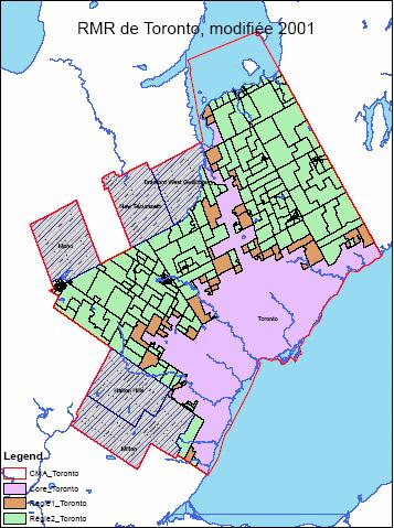
12 Delineation of urban areas Impact - Toronto urban area could combine with Oshawa and Hamilton to form one urban area and therefore one metropolitan area
13
14 Urban area population criteria for metropolitan areas Both countries require urban areas of a minimum size for metropolitan areas. United States urban area (urbanized area) of at least 50,000 Canada total CA population of at least 100,000 with at least 50,000 resident in the urban core Impact: For 2006 Census, American threshold would classify 16 CAs as CMAs (increase from 33 to 49)
15 Target core delineation Need target core for commuting calculations Define by including whole counties or municipalities to the target core: United States: at least 50% of county population or at least 5000 persons are resident with urbanized area - forms central county (or counties) Canada: a municipality becomes part of the target core if 75% of the CSD population is in the urban area Impact on metropolitan delineation: Affect of urban area delineation differences are dampened, impact is on timing of community entry because of population thresholds and building block differences
16 Delineation of the hinterland Commuting data forward and reverse commuting Commuting thresholds
17 Commuting data forward and reverse commuting Use place of work and place of residence data (commuting data) to delineate the hinterland Forward commuting commuting from an outlying community to the target core Reverse commuting commuting from the target core to outlying community Impact: No difference
18 Commuting thresholds United States: Forward commuting - at least 25% of the employed residents of the county work in the central county (counties) Reverse commuting at least 25% of the employment in the county is accounted for by workers residing in the central county (counties) of the metropolitan area Canada: Forward commuting at least 50% Reverse commuting at least 25%
19 Commuting thresholds (cont d) Forward commuting: Absolute forward commuting threshold differences reflect differences in geographic building block National out-commuting averages Equivalent Reverse commuting Absolute reverse commuting threshold are the same despite differences in building blocks Equivalent?
20 Commuting thresholds (cont d) Impact: Little impact more-or-less equivalent attempts at calibration
21 Mergers Merger criteria differ United States: Two adjacent CBSAs are merged if central county (counties) of one CBSA meet the commuting requirements to the central county (counties) of the other CBSA Canada: No CMA to CMA mergers only CA to CMA mergers Total forward commuting interchange is equal to 35% of the resident employed labour force of the CA
22 Mergers (cont d) Impact: Where mergers are permitted Canadian criteria require less commuting exchange In the case of Toronto CMA none of the peripheral CAs would merge when applying the US criteria (over 225,000 people or almost 5% of the total 2001 CMA population)
23
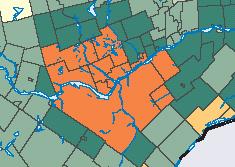
24 Delineation of sub-centres within metropolitan areas United States: procedures to delineate metropolitan divisions No equivalent procedure in Canada Impact: Application of American methodology to the Toronto CMA would identify the municipality of Mississauga as a metropolitan division Perhaps 4 other CMAs could be considered
25 Consolidations metropolitan regions United States: procedures to consolidate (combine) CBSAs Combine if employment interchange is 25% or more (% of forward commuting from smaller CBSA to larger plus % reverse commuting from larger CBSA to smaller) Combine if supported locally when employment interchange is from 15% to less than 25%. Canada: no directly equivalent procedure in Canada. Is partly reflected in the merger criteria but only applies to combining CAs with CMAs. No CMA with CMA consolidation.
26 Consolidations metropolitan regions Impact: Toronto as the test case Oshawa at 60% employment interchange would be combined ( ,298 ) Hamilton at 20% employment interchange could be combined depending on local input ( ,401) Potential increase of 958, 669 or 20% All peripheral CAs would be combined with Toronto under this criteria

27 Summary Differences National level and metropolitan specific comparisons Urban areas Same number Same start point Comparable Urban area limits Canada retains historic limits - splits relative to CMAs US would create one urban area Potential for an impact in Canada for individual CMAs Toronto area Thresholds different Effects national comparability but can be adjusted
28 Summary (cont d) Target core Same process different thresholds Dampens urban area limit differences - more a question of when Little impact at national level but could impact individual metropolitan area comparisons Commuting data and thresholds Same data Same approach to calibrating thresholds Equivalent
29 Summary (cont d) Geographic building block Different smaller in Canada more precise delineations less over or under bounding US building block delineates larger metropolitan areas In 1990 in collaboration with Richard L. Forstall of the U.S. Census Bureau exchanged and applied methodologies in US over bounding 9 to 35% and under bounding 10 to 20% Methodology in United States has changed
30 Summary (cont d) Cumulative impact needs testing Canada / USA Comparison, slide from presentation by Marc J. Perry, Population Division, U.S. Census Bureau, presentation at the Annual Meeting of the Association of American Geographers, Chicago, Illinois, March ) 70% / 83%

31 Canada / USA Comparison
32
33 Summary (cont d) Cumulative impact needs testing MIZ strong 5%, moderate 8% Real settlement difference or methodology difference?
34 Summary (cont d) Mergers An impact on national and individual metropolitan area comparability 11 of 33 CMAs in Canada are impacted Reduce CMA population by about 700,000 or 4%
35 Summary (cont d) Sub-centres No comparable criteria in Canada No impact at national level or individual metropolitan area Does conceal metropolitan area complexity and makes intra-metro comparisons more difficult but limited (2 to 4 ) CMAs
36 Summary (cont d) Combining metropolitan areas CAs not included in CMAs in Canada using the US merger criteria could be combined to form metropolitan regions when applying US criteria for combining CBSAs Need to apply consolidation criteria between CMAs as well to create comparable metropolitan regions
37 Best Comparisons Three categories of best comparisons re CMAs to metropolitan statistical areas Group 1: direct one to one comparisons (20 CMAs) Group 2: CMA to combined statistical area (8 CMAs) CA mergers are included in the CMA, no issues with adjacent CMAs Some CAs could merger with CMAs based on US criteria but more likely not all (if all then these CMAs would be in group 1) Group 3: CMA is not comparable (5 CMAs) CA mergers present but CMA to CMA combinations are not included Caught somewhere in between Group 1 and 2 Shaded CMAs could become part of metropolitan region under combination (consolidation) criteria (5 CMAs also in group 1)
38 Group 1 Group 2 Group 3 Greater Sudbury Calgary Abbotsford Halifax Edmonton Barrie Kelowna London Brantford Kingston Montreal Guelph Moncton Ottawa-Gatineau Kitchener Peterborough Saguenay Hamilton Quebec St. John's Oshawa Regina W indsor St. Catharines-Niagara Saint John Toronto Saskatoon Vancouver Sherbrooke Thunder Bay Trois-Rivieres Victoria W innipeg
Population Density. Population density: A measure of how crowded a place is.
 Population Density Population density: A measure of how crowded a place is. Formula: Population Density = Population Total Area km 2 Overall Canada has a low population density of about 3 people per km
Overcoming creative disadvantage in rural areas with networked economic development strategies
 Overcoming creative disadvantage in rural areas with networked economic development strategies Post Doctoral Research Fellow Munk School of Global Affairs University of Toronto Personal and research background
Rural Alabama. Jennifer Zanoni. Geography Division U.S. Census Bureau. Alabama State Data Center 2018 Data Conference Tuscaloosa, Alabama
 Rural Alabama Jennifer Zanoni Geography Division U.S. Census Bureau Alabama State Data Center 2018 Data Conference Tuscaloosa, Alabama May 17, 2018 Agenda Census Geography Urban/Rural Definitions County-based
SHELTER CAPACITY REPORT
 2013-2014 SHELTER CAPACITY REPORT 1 Table of Contents Introduction... 3 Highlights... 4 National Summary: Emergency Homeless Shelters... 5 Emergency Shelters by Clientele Served... 5 Emergency shelters
DRAFT RURAL-URBAN POPULATION CHANGE IN PUERTO RICO, 1990 TO 2000
 DRAFT RURAL-URBAN POPULATION CHANGE IN PUERTO RICO, 1990 TO 2000 Mei-Ling Freeman Geographic Standards and Criteria Branch Geography Division US Census Bureau For presentation at the Western Regional Science
Grade 9 Social Studies Canadian Identity. Chapter 3 Review Canada s People. Chapter 3: Canada s People
 Grade 9 Social Studies Canadian Identity Chapter 3 Review Canada s People Chapter 3: Canada s People Terms (notes or textbook) Population Distribution Site Factors Seigneurial system Corridors Urbanization
Population Change. Alessandro Alasia Agriculture Division Statistics Canada. (ICRPS) Summer School 2009
 Summer School 2009") Population Change in Rural Areas Seminar presented by Alessandro Alasia Agriculture Division Statistics Canada alessandro.alasia@statcan.gc.ca International Comparative Rural Policy Studies (ICRPS) Summer
Population Change in Rural Areas Seminar presented by Alessandro Alasia Agriculture Division Statistics Canada alessandro.alasia@statcan.gc.ca International Comparative Rural Policy Studies (ICRPS) Summer
Urban Development, Ontario and Quebec: Outline and Overview
 Centre for Urban and Community Studies UNIVERSITY OF TORONTO Urban Policy History Archive Urban Development, Ontario and Quebec: Outline and Overview L. S. Bourne and A. M. Baker Research Report No. 1
Rural Pennsylvania: Where Is It Anyway? A Compendium of the Definitions of Rural and Rationale for Their Use
 Rural Pennsylvania: Where Is It Anyway? A Compendium of the Definitions of Rural and Rationale for Their Use Pennsylvania Office of Rural Health 310 Nursing Sciences Building University Park, PA 16802
The paper is based on commuting flows between rural and urban areas. Why is this of
 Commuting 1 The paper is based on commuting flows between rural and urban areas. Why is this of interest? Academically, extent of spread of urban agglomeration economies, also the nature of rural-urban
The History Behind Census Geography
 The History Behind Census Geography Michael Ratcliffe Geography Division US Census Bureau Tennessee State Data Center August 8, 2017 Today s Presentation A brief look at the history behind some of the
05/03/2017 Page 1 of 16. Alberta. Total % Change. United Way / Centraide Change Change Change. % Change
 GCWCC - National Results - Comparative Results - - Campaign () CCMTGC - Résultats nationaux - Résultats comparatifs - Campagne - (ment de ) Alberta Alberta Capital Region $311,634 $284,551-8.69 $209,079
The History Behind Census Geography
 The History Behind Census Geography Michael Ratcliffe Geography Division US Census Bureau Kentucky State Data Center Affiliate Meeting August 5, 2016 Today s Presentation A brief look at the history behind
HOUSING NOW Ontario Region
 Housing Market Information HOUSING NOW Date Released: Second Quarter 2015 New Home Market Ontario seasonally adjusted annualized home starts (SAAR 1 ) slowed in the first quarter of 2015 declining to 55,188
Geographic Locations Survey of Clinical Psychologists in Canada
 Geographic Locations Survey of Clinical Psychologists in Canada A publication of the Canadian Psychological Association. 1999 To order print copies, click here! Print copies of this CPA document are available
The Periphery in the Knowledge Economy
 REGIONS IN THE KNOWLEDGE ECONOMY REGIONS ET ECONOMIE DU SAVOIR Mario Polese Richard Shearmur, in collaboration with Pierre-Marcel Desjardins Marc Johnson The Periphery in the Knowledge Economy The Spatial
HOW FAR TO THE NEAREST PHYSICIAN?
 Rural and Small Town Canada Analysis Bulletin Catalogue no. 21-006-XIE Vol. 1, No. 5 (March 1999) HOW FAR TO THE NEAREST PHYSICIAN? Edward Ng, Russell Wilkins, Jason Pole and Owen B. Adams HIGHLIGHTS In
Saskatoon Region Economic Diversity Report
 Saskatoon Region Economic Diversity Report Economic Diversity: Empirical Calculations and Comparisons In order to analyse the economic diversity of the Saskatoon Region, we first had to answer a few questions:
Human Geography. Urban Development. Urban Development. Urban Development. Unit 8: Urban Development. I. Why are Settlements Established?
 I. Why are Settlements Established? A. Rural Settlements B. Urban Settlements Human Geography Unit 8: I. Why are Settlements Established? C. REASONS FOR ESTABLLISHING SETTLEMENTS 1. Cultural Religious
Urban settlements delimitation using a gridded spatial support
 Urban settlements delimitation using a gridded spatial support Rita Nicolau 1, Elisa Vilares 1, Cristina Cavaco 1, Ana Santos 2, Mário Lucas 2 1 - General Directorate for Territory Development DGT, Portugal
Rural and Small Town Canada Analysis Bulletin Catalogue no XIE Vol. 2, No.6 (March 2001)
") Rural and Small Town Canada Analysis Bulletin Catalogue no. 21-006-XIE Vol. 2, No.6 (March 2001) EMPLOYMENT STRUCTURE IN RURAL AND SMALL TOWN CANADA: AN OVERVIEW Roland Beshiri, Statistics Canada Highlights
Rural and Small Town Canada Analysis Bulletin Catalogue no. 21-006-XIE Vol. 2, No.6 (March 2001) EMPLOYMENT STRUCTURE IN RURAL AND SMALL TOWN CANADA: AN OVERVIEW Roland Beshiri, Statistics Canada Highlights
City definitions. Sara Ben Amer. PhD Student Climate Change and Sustainable Development Group Systems Analysis Division
 City definitions Sara Ben Amer PhD Student Climate Change and Sustainable Development Group Systems Analysis Division sbea@dtu.dk Contents 1. Concept of a city 2. Need for the city definition? 3. Challenges
GIS and Cartography at the University of Toronto Technical Paper Series - Paper no. 2
 GCUT - GIS and Cartography at the University of Toronto Technical Paper Series University of Toronto, Department of Geography and Program in Planning This series is published as a technical complement
Catalogue No. 92F0171GIE Cartographic Boundary Files 2001 Census Second Edition Reference Guide
 Catalogue No. 92F0171GIE Cartographic Boundary Files 2001 Census Second Edition Reference Guide How to obtain more information Specific inquiries about this product and related statistics or services should
SOCIO-DEMOGRAPHIC INDICATORS FOR REGIONAL POPULATION POLICIES
 SOCIO-DEMOGRAPHIC INDICATORS FOR REGIONAL POPULATION POLICIES A CANADIAN PERSPECTIVE Marc Termote Université de Montréal Potsdam, DART Conference, September 3, 2012 3 STEPS 1. Defining the problem 2. Identifying
2018 Technical Standards and Safety Authority and Ministry of Advanced Education & Skills Development Examination Schedule
 Ministry of Advanced Education & Skills Development ination Schedule Last Updated: June 7, 2018 Document Uncontrolled if Printed ination Schedule Preface: The following sets out and identifies the 2018
Methodological issues in the development of accessibility measures to services: challenges and possible solutions in the Canadian context
 Methodological issues in the development of accessibility measures to services: challenges and possible solutions in the Canadian context Alessandro Alasia 1, Frédéric Bédard 2, and Julie Bélanger 1 (1)
Identifying Megaregions in the US: Implications for Infrastructure Investment
 7. 10. 2 0 08 Identifying Megaregions in the US: Implications for Infrastructure Investment Dr. Myungje Woo Dr. Catherine L. Ross Jason Barringer Harry West Jessica Lynn Harbour Doyle Center for Quality
US Census Bureau Geographic Entities and Concepts. Geography Division
 US Census Bureau Geographic Entities and Concepts Geography Division Geographic Concepts Addresses vs. Geographic features and entities Legal/Administrative vs. Statistical Nesting relationships (or the
DETERMINANTS OF MANUFACTURING EFFICIENCY IN CANADIAN CITIES: A STOCHASTIC FRONTIER APPROACH
 DETERMINANTS OF MANUFACTURING EFFICIENCY IN CANADIAN CITIES: A STOCHASTIC FRONTIER APPROACH Kim McCoy and Ronald L. Moomaw* Abstract-This study uses panel data to estimate stochastic production frontiers
Improving rural statistics. Defining rural territories and key indicators of rural development
 Improving rural statistics Defining rural territories and key indicators of rural development Improving rural statistics Improving Rural Statistics In 2016, the Global Strategy to improve Agricultural
Regional Snapshot Series: Transportation and Transit. Commuting and Places of Work in the Fraser Valley Regional District
 Regional Snapshot Series: Transportation and Transit Commuting and Places of Work in the Fraser Valley Regional District TABLE OF CONTENTS Complete Communities Daily Trips Live/Work Ratio Commuting Local
Census Transportation Planning Products (CTPP)
") Census Transportation Planning Products (CTPP) Penelope Weinberger CTPP Program Manager - AASHTO September 15, 2010 1 What is the CTPP Program Today? The CTPP is an umbrella program of data products, custom
Census Transportation Planning Products (CTPP) Penelope Weinberger CTPP Program Manager - AASHTO September 15, 2010 1 What is the CTPP Program Today? The CTPP is an umbrella program of data products, custom
A Method for Mapping Settlement Area Boundaries in the Greater Golden Horseshoe
 A Method for Mapping Settlement Area Boundaries in the Greater Golden Horseshoe Purpose This paper describes a method for mapping and measuring the lands designated for growth and urban expansion in the
DEFINING AND MEASURING WORLD-METRO REGIONS FOR INTERNATIONAL COMPARISONS
 DEFINING AND MEASURING WORLD-METRO REGIONS FOR INTERNATIONAL COMPARISONS Mario Piacentini, OECD 27th Scorus Conference, 11-13 August 2010, Latvia Why we need comparable measures of city performance Growing
Geographic Boundaries of Population Census of Japan 1
 UNITED NATIONS SECRETARIAT ESA/STAT/AC.279/P20 Department of Economic and Social Affairs October 2013 Statistics Division English only United Nations Expert Group on the Integration of Statistical and
Overview of National Seismic Hazard Maps for the next National Building Code
 Overview of National Seismic Hazard Maps for the next National Building Code John Adams Earthquakes Canada Geological Survey of Canada Copyright. Her Majesty the Queen in Right of Canada, 2004 CSCE Workshop
USING DOWNSCALED POPULATION IN LOCAL DATA GENERATION
 USING DOWNSCALED POPULATION IN LOCAL DATA GENERATION A COUNTRY-LEVEL EXAMINATION CONTENT Research Context and Approach. This part outlines the background to and methodology of the examination of downscaled
Operational Definitions of Urban, Rural and Urban Agglomeration for Monitoring Human Settlements
 Operational Definitions of Urban, Rural and Urban Agglomeration for Monitoring Human Settlements By Markandey Rai United Nations Human Settlements Programme PO Box-30030 Nairobi, Kenya Abstract The United
REMOTENESS INDICATORS AND FIRST NATION EDUCATION FUNDING
 REMOTENESS INDICATORS AND FIRST NATION EDUCATION FUNDING April 2018 Prepared by: Moazzami Economic Consultants Inc. Moazzami Economic Consultants Inc. (MEC) - Dr. Bakhtiar Moazzami, PhD. Economics Moazzami
Sharthi Laldaparsad Statistics South Africa, Policy Research & Analysis. Sub-regional workshop on integration of administrative data,
 Sub-regional workshop on integration of administrative data, big data and geospatial information for the compilation of SDG indicators and International Workshop on Global Fundamental Geospatial Data Themes
What do you need to know to navigate through the FTP Census Geography site?
 What s the scoop on FTP Census Geography What do you need to know to navigate through the FTP Census Geography site? First, know this: Every census team has come up with a different way to present their
ESPON Typology Compilation. Kai Böhme Sabine Zillmer, Kai Pflanz, Tomas Hanell & Petteri Niemi
 ESPON Typology Compilation Kai Böhme Sabine Zillmer, Kai Pflanz, Tomas Hanell & Petteri Niemi Scope of the study Tasks Compilation / assessment of existing typologies of typologies for ESPON Interim report
Spatial Organization of Data and Data Extraction from Maptitude
 Spatial Organization of Data and Data Extraction from Maptitude N. P. Taliceo Geospatial Information Sciences The University of Texas at Dallas UT Dallas GIS Workshop Richardson, TX March 30 31, 2018 1/
One Variable and Two Variable Statistics
 Name: Class: Date: ID: A One Variable and Two Variable Statistics Short Answer 1. When recommending five mutual funds for you to consider, your financial planner mentions that the typical minimum investment
Monica Brezzi (with (with Justine Boulant and Paolo Veneri) OECD EFGS Conference Paris 16 November 2016
 OECD EFGS Conference Paris 16 November 2016") ESTIMATING INCOME INEQUALITY IN OECD METROPOLITAN AREAS Monica Brezzi (with (with Justine Boulant and Paolo Veneri) OECD EFGS Conference Paris 16 November 2016 Outline 1. 2. 3. 4. 5. 6. Context and objectives
ESTIMATING INCOME INEQUALITY IN OECD METROPOLITAN AREAS Monica Brezzi (with (with Justine Boulant and Paolo Veneri) OECD EFGS Conference Paris 16 November 2016 Outline 1. 2. 3. 4. 5. 6. Context and objectives
Census Geography, Geographic Standards, and Geographic Information
 Census Geography, Geographic Standards, and Geographic Information Michael Ratcliffe Geography Division US Census Bureau New Mexico State Data Center Data Users Conference November 19, 2015 Today s Presentation
Socials Studies. Chapter 3 Canada s People 3.0-Human Geography
 Socials Studies Chapter 3 Canada s People 3.0-Human Geography Physical Geography Study of the natural features of the Earth s surface including landforms, climate, ocean currents and flora and fauna Human
Dr. Christoph Stadel Salzburg University, Austria
 Core areas and peripheral regions of Canada: Landscapes of contrast and challenge Dr. Christoph Stadel Salzburg University, Austria Regions vary widely in their capacity to achieve full development, and
You can't get there from here: Mapping access to Canada's teacher education programs
 You can't get there from here: Mapping access to Canada's teacher education programs Cameron William Smith, Peter Peller Werklund School of Education, University of Calgary Context/Process Initial, exploratory
Frontier and Remote (FAR) Area Codes: A Preliminary View of Upcoming Changes John Cromartie Economic Research Service, USDA
 Area Codes: A Preliminary View of Upcoming Changes John Cromartie Economic Research Service, USDA") National Center for Frontier Communities webinar, January 27, 2015 Frontier and Remote (FAR) Area Codes: A Preliminary View of Upcoming Changes John Cromartie Economic Research Service, USDA The views
National Center for Frontier Communities webinar, January 27, 2015 Frontier and Remote (FAR) Area Codes: A Preliminary View of Upcoming Changes John Cromartie Economic Research Service, USDA The views
APPENDIX IV MODELLING
 APPENDIX IV MODELLING Kingston Transportation Master Plan Final Report, July 2004 Appendix IV: Modelling i TABLE OF CONTENTS Page 1.0 INTRODUCTION... 1 2.0 OBJECTIVE... 1 3.0 URBAN TRANSPORTATION MODELLING
Social Indicators and Trends 2014
 Social Indicators and Trends 2014 Healthy City for All Target Add to the Greenest City Action Plan, a biodiversity target and a target related to toxins prevention. By 2025: every Vancouver neighbourhood
Smart Growth: Threat to the Quality of Life. Experience
 Smart Growth: Threat to the Quality of Life Presentation by Wendell Cox Wendell Cox Consultancy Visiting Professor Conservatoire National des Arts et Metiers Paris Frontier Centre for Public Policy Winnipeg
Council Workshop on Neighbourhoods Thursday, October 4 th, :00 to 4:00 p.m. Burlington Performing Arts Centre
 Council Workshop on Neighbourhoods Thursday, October 4 th, 2012 1:00 to 4:00 p.m. Burlington Performing Arts Centre Agenda Introductions Warm-Up Exercise Presentation Exercise Neighbourhood Planning Break
The Census, Urbanized Areas, and Your MPO/RPO
 The Census, Urbanized Areas, and Your MPO/RPO Alex Bond, AICP NADO Rural Transportation Peer Learning Conference August 25, 2011 1 Issues to Discuss Census background Definitions of Census geographies
ONE REGION: PLANNING FOR A STRONG AND JUST METROPOLIS. NYLON # 14: Regional Planning. October 31, 2018
 DRAFT ONE REGION: PLANNING FOR A STRONG AND JUST METROPOLIS NYLON # 14: Regional Planning October 31, 2018 Carolyn Grossman Meagher, Director, Regional Planning Division the New Yorker March 1976. A New
Data, Boundaries, Competitiveness: The TORONTO URBAN REGION in Global Context
 Data, Boundaries, Competitiveness: The TORONTO URBAN REGION in Global Context December 10, 2013 DATA, BOUNDARIES, COMPETITIVENESS: THE TORONTO URBAN REGION IN GLOBAL CONTEXT December 2013 Global City Indicators
Accessibility, rurality, remoteness an investigation on the Island of Sardinia, Italy
 UNIVERSITY OF SASSARI DIPARTIMENTO DI INGEGNERIA DEL TERRITORIO UNIVERSITY OF CAGLIARI DIPARTIMENTO DI FISICA AND DIPARTIMENTO DI INGEGNERIA DEL TERRITORIO Accessibility, rurality, remoteness an investigation
Mills, S.E Restructuring in the forest sector and the re-shaping of women s work identities. The Canadian Geographer. 56(1):
:") LIFETIME PUBLICATIONS 2014 Suzanne Elizabeth Mills a. Lifetime Publications i) Peer Reviewed a. books N/A b. contributions to books Mills, S.E. & McCreary, T 2012. Social unionism, partnership and conflict:
LIFETIME PUBLICATIONS 2014 Suzanne Elizabeth Mills a. Lifetime Publications i) Peer Reviewed a. books N/A b. contributions to books Mills, S.E. & McCreary, T 2012. Social unionism, partnership and conflict:
Data Sources and Methods for the Weather Warning Index. October 2014
 Data Sources and Methods for the Weather Warning Index October 2014 Suggested citation for this document: Environment Canada (2014) Canadian Environmental Sustainability Indicators: Data Sources and Methods
Preparing the GEOGRAPHY for the 2011 Population Census of South Africa
 Preparing the GEOGRAPHY for the 2011 Population Census of South Africa Sharthi Laldaparsad Statistics South Africa; E-mail: sharthil@statssa.gov.za Abstract: Statistics South Africa (Stats SA) s Geography
Changes in population and industries in the rural areas of Finland: from analysis of administrative regions to a GIS based approach
 Toivo Muilu*, Jarmo Rusanen** * University of Oulu, Department of Geography, Agrifood Research Finland, Ruukki Research Station P.O. Box 3000, FIN-90014, Finland toivo.muilu@oulu.fi ** University of Oulu,
Developing a global, peoplebased definition of cities and settlements
 Developing a global, peoplebased definition of cities and settlements By Lewis Dijkstra, Lewis.Dijkstra@ec.europa.eu Head of the Economic Analysis Sector DG for Regional and Urban Policy, Regional & Urban
Technical Documentation Demostats april 2018
 Technical Documentation Demostats 2018 april 2018 what it is DemoStats is a database of estimates and projections for a comprehensive set of demographic and socioeconomic attributes about the Canadian
THE ROYAL ASTRONOMICAL SOCIETY OF CANADA LA SOCIÉTÉ ROYALE D'ASTRONOMIE DU CANADA
 THE ROYAL ASTRONOMICAL SOCIETY OF CANADA LA SOCIÉTÉ ROYALE D'ASTRONOMIE DU CANADA Dear Member: Welcome to the Royal Astronomical Society of Canada (RASC)! Founded in 1868, the RASC is Canada s largest
Movement of population and firms in response to opportunities/incentives
 1 Movement of population and firms in response to opportunities/incentives Cities have been the primary subjects of investigation Basic Idea not new but Richard Florida s Creative Class notions and the
Housing Market Information
 Housing Market Information Housing NOW Victoria Canada Mortgage and Housing Corporation Date Released: May Homebuilding surges in s new home starts in Metro Victoria were more than triple March s level
Merging statistics and geospatial information
 Merging statistics and geospatial information Demography / Commuting / Spatial planning / Registers Mirosław Migacz Chief GIS Specialist Janusz Dygaszewicz Director Central Statistical Office of Poland
Secondary Towns and Poverty Reduction: Refocusing the Urbanization Agenda
 Secondary Towns and Poverty Reduction: Refocusing the Urbanization Agenda Luc Christiaensen and Ravi Kanbur World Bank Cornell Conference Washington, DC 18 19May, 2016 losure Authorized Public Disclosure
Technical Memorandum #2 Future Conditions
 Technical Memorandum #2 Future Conditions To: Dan Farnsworth Transportation Planner Fargo-Moorhead Metro Council of Governments From: Rick Gunderson, PE Josh Hinds PE, PTOE Houston Engineering, Inc. Subject:
Whither Regionalism: The Salience of Megaregional Geographies for Inter-Metropolitan Planning and Policy Making
 Whither Regionalism: The Salience of Megaregional Geographies for Inter-Metropolitan Planning and Policy Making Michael Oden, Ph.D Community and Regional Planning Program University of Texas at Austin
Using Census data for comparing trends in 74 British City Regions
 Using Census data for comparing trends in 74 British City Regions Mike Coombes, Tony Champion CURDS (Centre for Urban & Regional Development Studies) Newcastle University Acknowledgements: This paper uses
How the science of cities can help European policy makers: new analysis and perspectives
 How the science of cities can help European policy makers: new analysis and perspectives By Lewis Dijkstra, PhD Deputy Head of the Economic Analysis Unit, DG Regional and European Commission Overview Data
Labour MarketAreas: ThePortuguese case
 «Labour MarketAreas: ThePortuguese case Elsa Soares Rossano Figueiredo Unit for the Coordination of Territorial Statistics Lisboa, 30 June 2016 « Overview 1 THE IMPORTANCE OF DEFINING FUNCTIONAL REGIONS
Name: Political. Map of Canada. Map #1 - Locations to be labelled:
 5. Sketch in the west and east coast of the United States and label the U.S.A. 6. Label St. Pierre et Miquelon (France) 8. Colour the water blue and the United States green. Political maps are designed
Requests to Alberta Government Departments, Agencies, Boards and Commissions. April 1, 2010 March 31, 2011
 Statistics to Alberta Government Departments, Agencies, s and Commissions April 1, 2010 March 31, 2011 (See also FOIP Annual Report 2010-2011) Number of requests made to the Alberta Government April 1,
Defining Metropolitan Regions (MRs): coping with complexity
: coping with complexity") OECD Paris 27 November 2006 Defining Metropolitan Regions (MRs): coping with complexity Mike Coombes CURDS Newcastle University Britain Acknowledgements CURDS colleagues eg. Simon Raybould Past sponsors
OECD Paris 27 November 2006 Defining Metropolitan Regions (MRs): coping with complexity Mike Coombes CURDS Newcastle University Britain Acknowledgements CURDS colleagues eg. Simon Raybould Past sponsors
Kai Böhme Kai Böhme Sabine Zillmer, Kai Pflanz, Tomas Hanell & Petteri Niemi
 ESPON Typology ogy Compilation o Kai Böhme Kai Böhme Sabine Zillmer, Kai Pflanz, Tomas Hanell & Petteri Niemi Scope of the study Tasks Compilation / assessment of existing typologies of typologies for
Refinement of the OECD regional typology: Economic Performance of Remote Rural Regions
 [Preliminary draft April 2010] Refinement of the OECD regional typology: Economic Performance of Remote Rural Regions by Lewis Dijkstra* and Vicente Ruiz** Abstract To account for differences among rural
Difference in regional productivity and unbalance in regional growth
 Difference in regional productivity and unbalance in regional growth Nino Javakhishvili-Larsen and Jie Zhang - CRT, Denmark, Presentation at 26 th International input-output conference in Brazil Aim of
Proposal for International Workshop on Defining and Measuring Metropolitan Regions. II. Definition and Measurement of Metropolitan Area in Japan
 November 20, 2006 Proposal for International Workshop on Defining and Measuring Metropolitan Regions Japanese Government I. Introduction II. Definition and Measurement of Metropolitan Area in
Passenger Transportation Networks & Urbanization Level: A Comparison of Classification Schemes
 Pyrialakou, Nlenanya, Gkritza 0 0 Passenger Transportation Networks & Urbanization Level: A Comparison of Classification Schemes V. Dimitra Pyrialakou (Corresponding author) Graduate Research Assistant,
Gentrification Trends in the United States,
 Gentrification Trends in the United States, 1970-2010 Richard W. Martin, Department of Insurance, Legal, Studies, and Real Estate, Terry College of Business, University of Georgia, 206 Brooks Hall, Athens,
Regional Manufacturing Employment Volatility in Canada: The Effects of Specialization and Trade
 Catalogue No. 11F007MIE No. 005 ISSN: 1703-0404 ISBN: 0-66-3408-0 Research Paper Regional Manufacturing Employment Volatility in Canada: The Effects of Specialization and Trade by John R. Baldwin, W. Mark
Communities in Transition: Planning for No-Growth, Slow Growth or Decline. Mark Seasons, School of Planning, University of Waterloo
 Leveraging Ontario s Urban Potential: Mid-Sized Cities Research Series Public Finance & Governance Communities in Transition: Planning for No-Growth, Slow Growth or Decline Mark Seasons, School of Planning,
NBER WORKING PAPER SERIES HOW HAPPY ARE YOUR NEIGHBOURS? VARIATION IN LIFE SATISFACTION AMONG 1200 CANADIAN NEIGHBOURHOODS AND COMMUNITIES
 NBER WORKING PAPER SERIES HOW HAPPY ARE YOUR NEIGHBOURS? VARIATION IN LIFE SATISFACTION AMONG 1200 CANADIAN NEIGHBOURHOODS AND COMMUNITIES John F. Helliwell Hugh Shiplett Christopher P. Barrington-Leigh
Catalogue No. 92F0146GIE. Dissemination Area Reference Maps 2001 Census Reference Guide
 Catalogue No. 92F0146GIE Dissemination Area Reference Maps 2001 Census Reference Guide How to obtain more information For information on the wide range of data available from Statistics Canada, you can
2/25/2019. Taking the northern and southern hemispheres together, on average the world s population lives 24 degrees from the equator.
 Where is the world s population? Roughly 88 percent of the world s population lives in the Northern Hemisphere, with about half north of 27 degrees north Taking the northern and southern hemispheres together,
Regional Growth Strategy Work Session Growth Management Policy Board
 Regional Growth Strategy Work Session Growth Management Policy Board September 6, 2018 1 Overview Recap June GMPB work session Objectives and outcomes Regional geographies Growth scenarios Breakout Discussion:
How proximity to a city influences the performance of rural regions by Lewis Dijkstra and Hugo Poelman
 n 01/2008 Regional Focus A series of short papers on regional research and indicators produced by the Directorate-General for Regional Policy Remote Rural Regions How proximity to a city influences the
Reference: climate data for Prince George and other locations at the back of this handout
 Name/Date: Socials 9 Unit 2: Cultures, Conflict, and Colonization in British North America 2A Physical Geography of Canada References: Cranny, M. (1998) Crossroads: A Meeting of Nations, Ch. 6 Canadian
The Rural Health Workforce. Policy Brief Series. Data and Issues for Policymakers in: Washington Wyoming Alaska Montana Idaho
 The Health Workforce Data and Issues for Policymakers in: Washington Wyoming Alaska Montana Idaho Policy Brief Series ISSUE #1: THE RURAL HEALTH WORKFORCE: CHALLENGES AND OPPORTUNITIES ISSUE #2: THE RURAL
Economic and Social Urban Indicators: A Spatial Decision Support System for Chicago Area Transportation Planning
 Economic and Social Urban Indicators: A Spatial Decision Support System for Chicago Area Transportation Planning Piyushimita Thakuriah (Vonu), P.S. Sriraj, Paul Metaxatos, Inshu Minocha & Tanushri Swarup
C e n t ral Indiana Growing Faster Than Rest of the State
 C E N T R A L I N D I A N A U N D E R S T A N D I N G T H E R E G I O N A N D I D E N T I F Y I N G C H O I C E S CENTER FOR URBAN POLICY AND THE ENVIRONMENT MAY 2001 C e n t ral Indiana Growing Faster
Negative Exponential Model Parameters and Centralization in Large Urban Areas in the U.S.,
 Negative Exponential Model Parameters and Centralization in Large Urban Areas in the U.S., 1950-2010 Abstract John R. Ottensmann Indiana University-Purdue University Indianapolis john.ottensmann@gmail.com
LOCAL GOVERNMENT ADMINISTRATION SERIES
 Public Policy Research Center University of Missouri St. Louis LOCAL GOVERNMENT ADMINISTRATION SERIES ISSUE #3 MARCH 2017 THE GOVERNOR IN GOVERNANCE: KEEPING THE PACE by Mark Tranel, Director, Public Policy
São Paulo Metropolis and Macrometropolis - territories and dynamics of a recent urban transition
 São Paulo Metropolis and Macrometropolis - territories and dynamics of a recent urban transition Faculty of Architecture and Urbanism of São Paulo University Prof. Dr. Regina M. Prosperi Meyer WC2 - World
R E SEARCH HIGHLIGHTS
 Canada Research Chair in Urban Change and Adaptation R E SEARCH HIGHLIGHTS Research Highlight No.8 November 2006 THE IMPACT OF ECONOMIC RESTRUCTURING ON INNER CITY WINNIPEG Introduction This research highlight
Census Urban Area Comparisons, 2000 to 2010
 THE HONORABLE ROGERS Mayor ANDERSON, Karl Dean, CHAIRMAN Chairman Census Urban Area Comparisons, 2000 to 2010 TCC May 2, 2012 MPOs/RPOs in Tennessee Regional Geographies in Middle TN Nashville MPO Clarksville