Spatial Thinking and Modeling of Network-Based Problems
|
|
|
- Clinton Lawson
- 5 years ago
- Views:
Transcription
1 Spatial Thinking and Modeling of Network-Based Problems Presentation at the SPACE Workshop Columbus, Ohio, July 1, 25 Shih-Lung Shaw Professor Department of Geography University of Tennessee Knoxville, TN
2 Spatial Thinking! Spatial data is embedded in many social science studies. We could choose to ignore the spatial component in our data sets, but it does not remove the fact that many of our data sets are spatial in nature.! Some examples of spatial concepts: location, distance, adjacency, connectivity, direction, hinterland, interaction,
3 Different Types of Network! Transportation networks: highway, railroad, waterway, air, pedestrian, bike,! Utility networks: electricity, water, sewer,! Communications networks: telephone, Internet,! Social/Economic/Cultural networks: church members, colleagues, supply chain,! Natural networks: rivers/streams, animal migration routes,
4 A Network Example! Let s start with an example of airline networks.! The following slides show six airline passenger networks of American, Continental, Delta, Northwest, United, and USAir among the 1 most populous cities in the 48 contiguous states (Source: Shaw, S-L., Hub Structures of Major U.S. Passenger Airlines, Journal of Transport Geography, 1(1), )! What are some spatial concepts embedded in these airline networks?
5 Note that the rankings change with the index applied to the BNA: Nashville, TN IND: Indianapolis, IN SDF: Louisville, KY MEM: Memphis, TN TYS: Knoxville, TN MKE: Milwaukee, WI
6 H i : standardized index measuring total number of direct connections. S i : standardized index measuring total number of shortest-path direct and indirect connections. V i : index measuring total distance of shortestpath direct and indirect connections.
7 H i & S i : measure only connectivity pattern of topological distance and do not consider location. V i : measures linkage pattern of real distance. It takes into account the location of nodes on the network and therefore favors those centrally located nodes.
8
9
10
11 ArcGIS 9 Airline Networks Demo
12 Reflection of Spatial Thinking:! Accessibility levels at the nodes in a network depend on their direct and indirect connections with other nodes and their locations in the network.! Geographic centrality alone does not explain the variations between the networks. It appears that network centrality also plays an important role in determining the rankings.
13 ! What are the implications of these different spatial structures chosen by individual airlines? Are some spatial patterns better than others?! Accessibility levels can be measured by different variables (e.g., topological distance that emphasizes connectivity vs. actual distance that emphasizes relative location with respect to other nodes). Is it better to choose the major hubs such that they have consistent top rankings among H i, S i, and V i?
14 Some spatially relevant questions: 1 Description: Where are the hubs? What are the hub-and-spoke network structures? 2 Explanation: Why does a particular network have x number of hubs? Why do airlines choose hubs at certain locations? 3 Prediction: How do we forecast interactions (flows) between the hubs? 4 Optimality: What is the optimal design of a hub-and-spoke network? " How many hubs? (numbering problem) " Where should the hubs be placed? (location problem) " How to allocate nodes to different hubs? (allocation problem) " How to route flows through the network? (routing problem)
15 Spatial Analysis/Spatial Modeling! spatial pattern and spatial analysis can rarely if ever be used to confirm theories, though they can certainly be used to deny false ones and to justify controlled experiments or longitudinal analysis where these are possible. In summary, spatial analysis is perhaps best seen as an exploratory technique, more suitable for the generation of hypotheses and insights than to strict confirmation of theory. (Source: Goodchild M.F. and Janelle, D.G., 24. Thinking Spatially in the Social Science, Spatially Integrated Social Science. New York: Oxford University Press, p. 7)
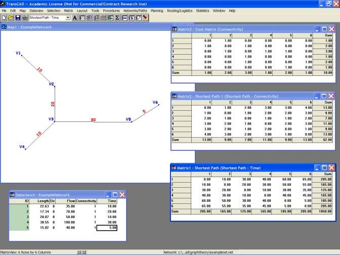
16 Network Analysis! Network analysis places an emphasis on the structures formed by linkages and nodes in a network.! Two relevant mathematical subfields are graph theory and topology.! Two common representation methods are: Network as a Graph: A network is represented as a set of nodes interconnected by a set of linkages. Network as a Matrix: A network is represented as a matrix of data between a set of origins and a set of destinations.
17 (Source: Taaffe, Gauthier, and O Kelly, Geography of Transportation.)
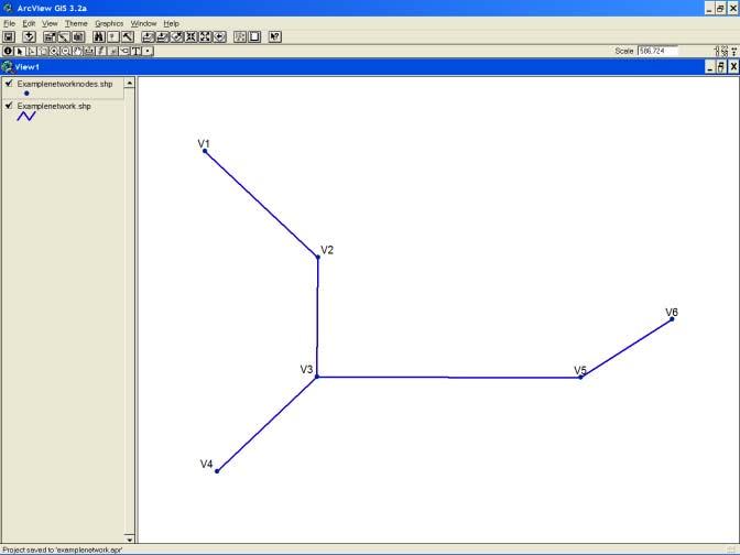
18 Representation of graphs and networks:! Undirected graph: implies that relationships are hold in both directions.! Directed graph: specifies relationships that hold only in particular directions.! Connectivity matrix (or adjacency matrix): Matrix rows and columns correspond to network nodes. If an arc exists between node i and node j, then x ij = 1 Otherwise, x ij =
19 N6 N5 N4 N3 N2 N1 N6 N5 N4 N3 N2 N1 N1 N2 N3 N4 N5 N6 Connectivity Matrix 1 N6 1 1 N5 1 N N3 1 1 N2 1 N1 N6 N5 N4 N3 N2 N Degree of a node
20 ! Node-arc incident matrix: Matrix rows correspond to nodes, while matrix columns correspond to arcs. x ij = 1 if node i is the start node of arc j x ij = -1 if node i is the end node of arc j Otherwise, x ij = N1 A1 N2 A2 A5 N6 A3 N3 A4 N5 N4
21 N6 N5 N4 N3 N2 N1 A5 A4 A3 A2 A1 A1 A2 A3 A4 A5 N1 N2 N3 N4 N5 N6 Node-Arc Incident Matrix -1 N6 1-1 N5 1 N N3 1-1 N2 1 N1 A5 A4 A3 A2 A1
22 ! Shortest-path matrix: Shortest-path matrix considers both direct and indirect linkages along the shortest path between each pair of nodes in a network.
23 N6 N5 N4 N3 N2 N1 N6 N5 N4 N3 N2 N1 N1 N2 N3 N4 N5 N Shortest-path Matrix N N N N N N1 N6 N5 N4 N3 N2 N Total
24 Network Representations in Commercial GIS! Almost all commercial GIS packages implement the network as a graph representation approach.! However, many commercial GIS packages do not support network as a matrix representation approach.! Also, most commercial GIS packages offer limited transportation analysis functions.
25
26
27 Some Basic Network Concepts:! Planar and Nonplanar Networks: Planar networks: * Linkages cannot cross each other without creating new intersection nodes. * e.g., most surface transport networks (exceptions include overpass/underpass, tunnel). Nonplanar networks: * Linkages can cross each other without creating new intersection nodes. * e.g., airline networks
28 Address Geocoding:! Address geocoding (also known as address matching) is a process that creates a point GIS map layer from street addresses. To match street addresses, GIS compares the address components in an address data file and the address range data in a GIS map layer.! What are components of addresses and what is a match? Address Data Address Range Data in GIS Layer a) 62 CENTER STREET CENTER AV b) 71 PALM AV W CENTER ST c) 68 1ST ST PALM AV W PALM AV E FIRST ST
29 Example of Address Geocoding Applications:! A company can match customer addresses against a street network to find out where the customers are located. The information can be used to perform marketing analysis.! Emergency dispatch operators can use geocoding to enter an address, determine who should respond, and route emergency vehicles and personnel to the specific address.! A school district can use geocoding to match student addresses against a GIS street map database. It can then develop school busing plans.! Environmental engineers can identify potential impacts of hazardous material storage facilities in populated areas by matching the site addresses to a GIS database and then perform spatial analysis with census data.

30
31 Address Geocoding/Network Analysis Exercise:! To download exercise files, please visit my web site for the 25 SPACE Summer Workshop at There are two files: Instructions for the exercise (Microsoft Word file) Data file (a self-extracting zip file)! You will need ESRI ArcView 3 with the Network Analyst extension to complete this exercise.
32 ArcView 3 Address Geocoding Demo
33 Reflection of Spatial Concepts:! Spatial data exist in many forms. Street addresses, ZIP codes, census unit IDs, telephone numbers (how about cell phones?) all include information about locations.! GIS offer geocoding functions to help convert implicit spatial data into explicit locations on a map.
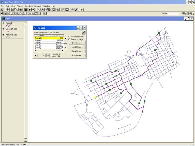
34 Solving Network-based Problems:! Shortest-Path Problem: Find the shortest (or best) path between two or more nodes on a network.! Traveling Salesman Problem (TSP): Given n nodes in a network, find the shortest (or best) tour of visiting each of the n nodes only once and returning to the starting node.
35
36
37
38
39 ArcView 3 Shortest-Path and TSP Demos
40 Reflection of Spatial Concepts:! The best tour of visiting a set of given nodes in a network is different from finding a sequence of shortest paths between adjacent nodes.! In other words, spatial proximity is not the only consideration in solving some network-based problems.! Connectivity between linkages is critical to solving many network-based problems. GIS representations must properly represent network connectivity.
41 Solving Network-based Problems: (cont.)! Vehicle Routing Problem (VRP): Vehicle Routing Problem is essentially a fleet version of the TSP. VRP is to find the best routes for a fixed number of vehicles from their respective depots to serve a set of demand locations such that the total cost is minimized and vehicle capacity constraints are not violated.

42
43
44 TransCAD VRP Demo
45 Reflection of Spatial Concepts:! VRP finds multiple best tours to serve subsets of the demand nodes in a network. This is a very hard (NP-hard) problem to solve because it needs to partition the demand locations into subsets and find the best tour for each subset at the same time.! VRP uses different spatial information (e.g., proximity, connectivity, direction), along with nonspatial information (e.g., number of vehicles, vehicle capacity, open time windows, demand levels) to solve the problem (mostly based on heuristic algorithms).
46 Table 5-1 (part 1): Algorithm complexity (Miller & Shaw, 21, p. 138)
47 Table 5-1 (part 2): Algorithm complexity (Miller & Shaw, 21, p. 138)
48 Solving Network-based Problems: (cont.)! Service Areas Delineation and Network Partitioning Problems: Service Area Delineation Problem identifies the accessible streets within a specified travel time or distance in a network and the service areas that encompass the accessible streets. Network Partitioning Problem partitions a network layer into zones or districts based on seed locations.
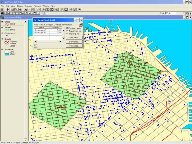
49
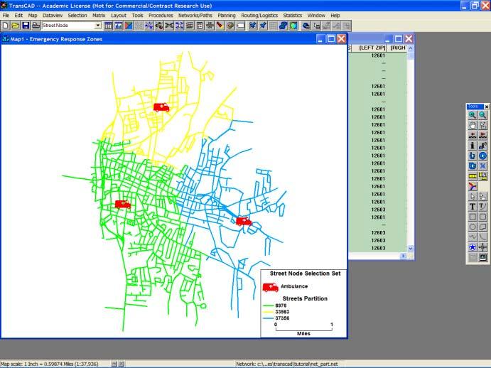
50
51 ArcView 3 Service Areas Delineation and TransCAD Network Partitioning Demos
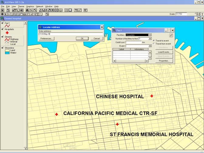
52 Solving Network-based Problems: (cont.)! Facility Location Problems: Facility Location Problems attempt to find optimal or near-optimal locations for activities such as warehouses, retail stores, public libraries, emergency service facilities to meet a demand pattern. There are many variations of facility location problems. Each is designed to solve a particular type of facility location problem according to its specific criteria.
53 TransCAD Facility Location Problem Demos
54 Reflection of Spatial Concepts:! A comprehensive facility location-routing problem involves solving numbering problem, location problem, allocation problem, and routing problem simultaneously.! Spatial data, in their implicit or explicit forms, provide critical information to solve network-based problems.
55 Thank You! Again, here is the information to download Address Geocoding/Network Analysis Exercise files:! To download exercise files, please visit my web site for the 25 SPACE Summer Workshop at There are two files: Instructions for the exercise (Microsoft Word file) Data file (a self-extracting zip file)! You will need ESRI ArcView 3 with the Network Analyst extension to complete this exercise.
Lecture 9: Geocoding & Network Analysis
 Massachusetts Institute of Technology - Department of Urban Studies and Planning 11.520: A Workshop on Geographic Information Systems 11.188: Urban Planning and Social Science Laboratory Lecture 9: Geocoding
Are You Maximizing The Value Of All Your Data?
 Are You Maximizing The Value Of All Your Data? Using The SAS Bridge for ESRI With ArcGIS Business Analyst In A Retail Market Analysis SAS and ESRI: Bringing GIS Mapping and SAS Data Together Presented
Network Analysis with ArcGIS Online. Deelesh Mandloi Dmitry Kudinov
 Deelesh Mandloi Dmitry Kudinov Introductions Who are we? - Network Analyst Product Engineers Who are you? - Network Analyst users? - ArcGIS Online users? - Trying to figure out what is ArcGIS Online? Slides
ArcGIS Online Routing and Network Analysis. Deelesh Mandloi Matt Crowder
 ArcGIS Online Routing and Network Analysis Deelesh Mandloi Matt Crowder Introductions Who are we? - Members of the Network Analyst development team Who are you? - Network Analyst users? - ArcGIS Online
GIS ANALYSIS METHODOLOGY
 GIS ANALYSIS METHODOLOGY No longer the exclusive domain of cartographers, computer-assisted drawing technicians, mainframes, and workstations, geographic information system (GIS) mapping has migrated to
Application of GIS in Public Transportation Case-study: Almada, Portugal
 Case-study: Almada, Portugal Doutor Jorge Ferreira 1 FSCH/UNL Av Berna 26 C 1069-061 Lisboa, Portugal +351 21 7908300 jr.ferreira@fcsh.unl.pt 2 FSCH/UNL Dra. FCSH/UNL +351 914693843, leite.ines@gmail.com
UTILIZING GIS IN NEXT GENERATION Tennessee Information for Public Safety. Presented by State of TN, OIR-GIS Services
 UTILIZING GIS IN NEXT GENERATION 9-1-1 Tennessee Information for Public Safety Presented by State of TN, OIR-GIS Services Next Generation 9-1-1 WHAT IT IS AND HOW IT WORKS Next Generation 9-1-1 IP (Internet
Algorithms and Complexity theory
 Algorithms and Complexity theory Thibaut Barthelemy Some slides kindly provided by Fabien Tricoire University of Vienna WS 2014 Outline 1 Algorithms Overview How to write an algorithm 2 Complexity theory
Outline. 15. Descriptive Summary, Design, and Inference. Descriptive summaries. Data mining. The centroid
 Outline 15. Descriptive Summary, Design, and Inference Geographic Information Systems and Science SECOND EDITION Paul A. Longley, Michael F. Goodchild, David J. Maguire, David W. Rhind 2005 John Wiley
Network Analysis Services in ArcGIS Enterprise. Deelesh Mandloi
 Network Analysis Services in ArcGIS Enterprise Deelesh Mandloi Slides from this demo theater http://esriurl.com/uc17nas Agenda Network Analyst concepts ArcGIS Enterprise publishing workflow - Geoprocessing
Chapter 3: Discrete Optimization Integer Programming
 Chapter 3: Discrete Optimization Integer Programming Edoardo Amaldi DEIB Politecnico di Milano edoardo.amaldi@polimi.it Sito web: http://home.deib.polimi.it/amaldi/ott-13-14.shtml A.A. 2013-14 Edoardo
The Trade Area Analysis Model
 The Trade Area Analysis Model Trade area analysis models encompass a variety of techniques designed to generate trade areas around stores or other services based on the probability of an individual patronizing
FHWA GIS Outreach Activities. Loveland, Colorado April 17, 2012
 FHWA GIS Outreach Activities Loveland, Colorado April 17, 2012 GIS for Improved Decision Making FHWA believes that geographic information systems and other geospatial technologies (remote sensing and GPS)
Reference: 4880(DOP.ADA)1136 Subject: Survey on the integration of geographic information systems into postal address development
1136 Subject: Survey on the integration of geographic information systems into postal address development") International Bureau Weltpoststrasse 4 P.O. Box 312 3000 BERNE 15 SWITZERLAND To: Union member countries Regulators Designated operators T +41 31 350 31 11 F +41 31 350 31 10 www.upu.int For information
International Bureau Weltpoststrasse 4 P.O. Box 312 3000 BERNE 15 SWITZERLAND To: Union member countries Regulators Designated operators T +41 31 350 31 11 F +41 31 350 31 10 www.upu.int For information
Applied Integer Programming: Modeling and Solution
 Applied Integer Programming: Modeling and Solution Chen, Batson, Dang Section 6. - 6.3 Blekinge Institute of Technology April 5, 05 Modeling Combinatorical Optimization Problems II Traveling Salesman Problem
Demographic Data in ArcGIS. Harry J. Moore IV
 Demographic Data in ArcGIS Harry J. Moore IV Outline What is demographic data? Esri Demographic data - Real world examples with GIS - Redistricting - Emergency Preparedness - Economic Development Next
Chapter 3: Discrete Optimization Integer Programming
 Chapter 3: Discrete Optimization Integer Programming Edoardo Amaldi DEIB Politecnico di Milano edoardo.amaldi@polimi.it Website: http://home.deib.polimi.it/amaldi/opt-16-17.shtml Academic year 2016-17
International ejournals
 ISSN 0976 1411 Available online at www.internationalejournals.com International ejournals International ejournal of Mathematics and Engineering 2 (2017) Vol. 8, Issue 1, pp 11 21 Optimization of Transportation
NR402 GIS Applications in Natural Resources
 NR402 GIS Applications in Natural Resources Lesson 1 Introduction to GIS Eva Strand, University of Idaho Map of the Pacific Northwest from http://www.or.blm.gov/gis/ Welcome to NR402 GIS Applications in
Optimization Exercise Set n.5 :
 Optimization Exercise Set n.5 : Prepared by S. Coniglio translated by O. Jabali 2016/2017 1 5.1 Airport location In air transportation, usually there is not a direct connection between every pair of airports.
LECTURE 1: INTRODUCTION
 LECTURE 1: INTRODUCTION What is a Network? What is a Network? What is the meaning of Network Flows? In our course, a network G=(N,A) consists of a finite number of nodes (in N) which are connected by arcs
Lecture 8: Column Generation
 Lecture 8: Column Generation (3 units) Outline Cutting stock problem Classical IP formulation Set covering formulation Column generation A dual perspective Vehicle routing problem 1 / 33 Cutting stock
John Laznik 273 Delaplane Ave Newark, DE (302)
") Office Address: John Laznik 273 Delaplane Ave Newark, DE 19711 (302) 831-0479 Center for Applied Demography and Survey Research College of Human Services, Education and Public Policy University of Delaware
Office Address: John Laznik 273 Delaplane Ave Newark, DE 19711 (302) 831-0479 Center for Applied Demography and Survey Research College of Human Services, Education and Public Policy University of Delaware
UNIT 4: USING ArcGIS. Instructor: Emmanuel K. Appiah-Adjei (PhD) Department of Geological Engineering KNUST, Kumasi
 Department of Geological Engineering KNUST, Kumasi") UNIT 4: USING ArcGIS Instructor: Emmanuel K. Appiah-Adjei (PhD) Department of Geological Engineering KNUST, Kumasi Getting to Know ArcGIS ArcGIS is an integrated collection of GIS software products ArcGIS
UNIT 4: USING ArcGIS Instructor: Emmanuel K. Appiah-Adjei (PhD) Department of Geological Engineering KNUST, Kumasi Getting to Know ArcGIS ArcGIS is an integrated collection of GIS software products ArcGIS
Algorithms and Theory of Computation. Lecture 22: NP-Completeness (2)
") Algorithms and Theory of Computation Lecture 22: NP-Completeness (2) Xiaohui Bei MAS 714 November 8, 2018 Nanyang Technological University MAS 714 November 8, 2018 1 / 20 Set Cover Set Cover Input: a set
Algorithms and Theory of Computation Lecture 22: NP-Completeness (2) Xiaohui Bei MAS 714 November 8, 2018 Nanyang Technological University MAS 714 November 8, 2018 1 / 20 Set Cover Set Cover Input: a set
Applied Cartography and Introduction to GIS GEOG 2017 EL. Lecture-2 Chapters 3 and 4
 Applied Cartography and Introduction to GIS GEOG 2017 EL Lecture-2 Chapters 3 and 4 Vector Data Modeling To prepare spatial data for computer processing: Use x,y coordinates to represent spatial features
Travel Time Calculation With GIS in Rail Station Location Optimization
 Travel Time Calculation With GIS in Rail Station Location Optimization Topic Scope: Transit II: Bus and Rail Stop Information and Analysis Paper: # UC8 by Sutapa Samanta Doctoral Student Department of
Data Structures and Algorithms (CSCI 340)
") University of Wisconsin Parkside Fall Semester 2008 Department of Computer Science Prof. Dr. F. Seutter Data Structures and Algorithms (CSCI 340) Homework Assignments The numbering of the problems refers
University of Wisconsin Parkside Fall Semester 2008 Department of Computer Science Prof. Dr. F. Seutter Data Structures and Algorithms (CSCI 340) Homework Assignments The numbering of the problems refers
Identifying Megaregions in the US: Implications for Infrastructure Investment
 7. 10. 2 0 08 Identifying Megaregions in the US: Implications for Infrastructure Investment Dr. Myungje Woo Dr. Catherine L. Ross Jason Barringer Harry West Jessica Lynn Harbour Doyle Center for Quality
Exploring Potential Human Activities in Physical and Virtual Spaces: A Spatio-temporal temporal GIS Approach
 Exploring Potential Human Activities in Physical and Virtual Spaces: A Spatio-temporal temporal GIS Approach Hongbo Yu Department of Geography, The University of Tennessee Knoxville, TN 37996-0925, USA
Neighborhood Locations and Amenities
 University of Maryland School of Architecture, Planning and Preservation Fall, 2014 Neighborhood Locations and Amenities Authors: Cole Greene Jacob Johnson Maha Tariq Under the Supervision of: Dr. Chao
94-802Z: Geographic Information Systems Summer 2018
 94-802Z: Geographic Information Systems Summer 2018 Instructor: Professor Kristen Kurland Teaching Assistant(s): (Office hours to be posted on Canvas) TBA Class Web Site: http:/www.cmu.edu/canvas
Georelational Vector Data Model
 Georelational Vector Data Model Contents Georelational Data Model Representation of Simple Features Topology Non-topological Vector Data Data Models for Composite Features Geo-relational Looking at a paper
Introduction INTRODUCTION TO GIS GIS - GIS GIS 1/12/2015. New York Association of Professional Land Surveyors January 22, 2015
 New York Association of Professional Land Surveyors January 22, 2015 INTRODUCTION TO GIS Introduction GIS - GIS GIS 1 2 What is a GIS Geographic of or relating to geography the study of the physical features
Optimization Prof. A. Goswami Department of Mathematics Indian Institute of Technology, Kharagpur. Lecture - 20 Travelling Salesman Problem
 Optimization Prof. A. Goswami Department of Mathematics Indian Institute of Technology, Kharagpur Lecture - 20 Travelling Salesman Problem Today we are going to discuss the travelling salesman problem.
Welcome to NR502 GIS Applications in Natural Resources. You can take this course for 1 or 2 credits. There is also an option for 3 credits.
 Welcome to NR502 GIS Applications in Natural Resources. You can take this course for 1 or 2 credits. There is also an option for 3 credits. The 1st credit consists of a series of readings, demonstration,
Your web browser (Safari 7) is out of date. For more security, comfort and. the best experience on this site: Update your browser Ignore
 is out of date. For more security, comfort and. the best experience on this site: Update your browser Ignore") Your web browser (Safari 7) is out of date. For more security, comfort and Activityengage the best experience on this site: Update your browser Ignore Introduction to GIS What is a geographic information
Your web browser (Safari 7) is out of date. For more security, comfort and Activityengage the best experience on this site: Update your browser Ignore Introduction to GIS What is a geographic information
Visualization of Places Based on Network Analysis through GIS
 Dagon University Research Journal 2014, Vol. 6 Visualization of Places Based on Network Analysis through GIS Win Win Shwe * Abstract Geographic Information System is a computer-based tool for mapping and
SRJC Applied Technology 54A Introduction to GIS
 SRJC Applied Technology 54A Introduction to GIS Overview Lecture of Geographic Information Systems Fall 2004 Santa Rosa Junior College Presented By: Tim Pudoff, GIS Coordinator, County of Sonoma, Information
A Review: Geographic Information Systems & ArcGIS Basics
 A Review: Geographic Information Systems & ArcGIS Basics Geographic Information Systems Geographic Information Science Why is GIS important and what drives it? Applications of GIS ESRI s ArcGIS: A Review
presents challenges related to utility infrastructure planning. Many of these challenges
 1 Introduction: - a. Purpose According to U.S. Census Bureau the population of stark county was 367,585 in 1990, and in 2000 it was increase to 378,098. Thus County is experiencing a growth that presents
8.5 Sequencing Problems
 8.5 Sequencing Problems Basic genres. Packing problems: SET-PACKING, INDEPENDENT SET. Covering problems: SET-COVER, VERTEX-COVER. Constraint satisfaction problems: SAT, 3-SAT. Sequencing problems: HAMILTONIAN-CYCLE,
Valdosta State University Strategic Research & Analysis
 Christopher Neasbitt, Programmer Analyst Associate (cjneasbi@valdosta.edu) Kristina M. Cragg, Ph.D., Assistant to the President for Strategic Research & Analysis (kmcragg@valdosta.edu) Amir Atabekov, Student
Lecture 3 GIS outputs. Dr. Zhang Spring, 2017
 Lecture 3 GIS outputs Dr. Zhang Spring, 2017 Model of the course Using and making maps Navigating GIS maps Map design Working with spatial data Geoprocessing Spatial data infrastructure Digitizing File
Geodatabase An Overview
 Federal GIS Conference February 9 10, 2015 Washington, DC Geodatabase An Overview Ralph Denkenberger - esri Session Path The Geodatabase - What is it? - Why use it? - What types are there? Inside the Geodatabase
Class 9. Query, Measurement & Transformation; Spatial Buffers; Descriptive Summary, Design & Inference
 Class 9 Query, Measurement & Transformation; Spatial Buffers; Descriptive Summary, Design & Inference Spatial Analysis Turns raw data into useful information by adding greater informative content and value
Acknowledgments xiii Preface xv. GIS Tutorial 1 Introducing GIS and health applications 1. What is GIS? 2
 Acknowledgments xiii Preface xv GIS Tutorial 1 Introducing GIS and health applications 1 What is GIS? 2 Spatial data 2 Digital map infrastructure 4 Unique capabilities of GIS 5 Installing ArcView and the
Scheduling and Optimization Course (MPRI)
") MPRI Scheduling and optimization: lecture p. /6 Scheduling and Optimization Course (MPRI) Leo Liberti LIX, École Polytechnique, France MPRI Scheduling and optimization: lecture p. /6 Teachers Christoph
MPRI Scheduling and optimization: lecture p. /6 Scheduling and Optimization Course (MPRI) Leo Liberti LIX, École Polytechnique, France MPRI Scheduling and optimization: lecture p. /6 Teachers Christoph
Sensitivity of estimates of travel distance and travel time to street network data quality
 Sensitivity of estimates of travel distance and travel time to street network data quality Paul Zandbergen Department of Geography University of New Mexico Outline Street network quality Approaches to
Geodatabase An Introduction
 Federal GIS Conference 2014 February 10 11, 2014 Washington DC Geodatabase An Introduction Ralph Denkenberger esri Session Path The Geodatabase - What is it? - Why use it? - What types are there? Inside
INTRODUCTION TO GEOGRAPHIC INFORMATION SYSTEM By Reshma H. Patil
 INTRODUCTION TO GEOGRAPHIC INFORMATION SYSTEM By Reshma H. Patil ABSTRACT:- The geographical information system (GIS) is Computer system for capturing, storing, querying analyzing, and displaying geospatial
CS 301: Complexity of Algorithms (Term I 2008) Alex Tiskin Harald Räcke. Hamiltonian Cycle. 8.5 Sequencing Problems. Directed Hamiltonian Cycle
 Alex Tiskin Harald Räcke. Hamiltonian Cycle. 8.5 Sequencing Problems. Directed Hamiltonian Cycle") 8.5 Sequencing Problems Basic genres. Packing problems: SET-PACKING, INDEPENDENT SET. Covering problems: SET-COVER, VERTEX-COVER. Constraint satisfaction problems: SAT, 3-SAT. Sequencing problems: HAMILTONIAN-CYCLE,
8.5 Sequencing Problems Basic genres. Packing problems: SET-PACKING, INDEPENDENT SET. Covering problems: SET-COVER, VERTEX-COVER. Constraint satisfaction problems: SAT, 3-SAT. Sequencing problems: HAMILTONIAN-CYCLE,
A Summary of State DOT GIS Activities. Presented at the 2000 AASHTO GIS-T Symposium Minneapolis, MN
 A Summary of State DOT GIS Activities Presented at the 2000 AASHTO GIS-T Symposium Minneapolis, MN Information Sources E-mail survey of state DOT GIS managers 49 State DOTs responded in 2000 Results compared
GIS and Spatial Statistics: One World View or Two? Michael F. Goodchild University of California Santa Barbara
 GIS and Spatial Statistics: One World View or Two? Michael F. Goodchild University of California Santa Barbara Location as attribute The data table Census summary table What value is location as an explanatory
MVE165/MMG630, Applied Optimization Lecture 6 Integer linear programming: models and applications; complexity. Ann-Brith Strömberg
 MVE165/MMG630, Integer linear programming: models and applications; complexity Ann-Brith Strömberg 2011 04 01 Modelling with integer variables (Ch. 13.1) Variables Linear programming (LP) uses continuous
Models and Cuts for the Two-Echelon Vehicle Routing Problem
 Models and Cuts for the Two-Echelon Vehicle Routing Problem Guido Perboli Roberto Tadei Francesco Masoero Department of Control and Computer Engineering, Politecnico di Torino Corso Duca degli Abruzzi,
GIS Based Transit Information System for Metropolitan Cities in India
 PAPER REFERENCE NO.: PN-250 GIS Based Transit Information System for Metropolitan Cities in India Pal, Sarvjeet. a and Singh, Varun. b a M. Tech. (GIS & Remote Sensing); GIS Cell; Motilal Nehru National
Lecture 8 Network Optimization Algorithms
 Advanced Algorithms Floriano Zini Free University of Bozen-Bolzano Faculty of Computer Science Academic Year 2013-2014 Lecture 8 Network Optimization Algorithms 1 21/01/14 Introduction Network models have
Spatial Concepts: Data Models 2
 Spatial Concepts: Data Models 2 2009/2010 CGI GIRS 2/31 Data modeling in 4 steps 1. Geographical perception Continuous phenomenon Discrete phenomena Virtual boundaries Tangible boundaries altitude, EM
SPATIAL ANALYSIS. Transformation. Cartogram Central. 14 & 15. Query, Measurement, Transformation, Descriptive Summary, Design, and Inference
 14 & 15. Query, Measurement, Transformation, Descriptive Summary, Design, and Inference Geographic Information Systems and Science SECOND EDITION Paul A. Longley, Michael F. Goodchild, David J. Maguire,
Representing and Visualizing Travel Diary Data: A Spatio-temporal GIS Approach
 2004 ESRI International User Conference, San Diego, CA Representing and Visualizing Travel Diary Data: A Spatio-temporal GIS Approach Hongbo Yu and Shih-Lung Shaw Abstract Travel diary data (TDD) is an
Spatial Organization of Data and Data Extraction from Maptitude
 Spatial Organization of Data and Data Extraction from Maptitude N. P. Taliceo Geospatial Information Sciences The University of Texas at Dallas UT Dallas GIS Workshop Richardson, TX March 30 31, 2018 1/
PC ARC/INFO and Data Automation Kit GIS Tools for Your PC
 ESRI PC ARC/INFO and Data Automation Kit GIS Tools for Your PC PC ARC/INFO High-quality digitizing and data entry Powerful topology building Cartographic design and query Spatial database query and analysis
Optimizing Roadside Advertisement Dissemination in Vehicular CPS
 Optimizing Roadside Advertisement Dissemination in Vehicular CPS Huanyang Zheng and Jie Wu Computer and Information Sciences Temple University 1. Introduction Roadside Advertisement Dissemination Passengers,
Partial Path Column Generation for the Vehicle Routing Problem with Time Windows
 Partial Path Column Generation for the Vehicle Routing Problem with Time Windows Bjørn Petersen & Mads Kehlet Jepsen } DIKU Department of Computer Science, University of Copenhagen Universitetsparken 1,
Node Edge Arc Routing Problems (NEARP)
") Node Edge Arc Routing Problems (NEARP) Nicolas Briot Coconut-LIRMM janvier 0 Nicolas Briot (Coconut-LIRMM) Node Edge Arc Routing Problems (NEARP) janvier 0 / What is NEARP? Arc and node routing problem
Node Edge Arc Routing Problems (NEARP) Nicolas Briot Coconut-LIRMM janvier 0 Nicolas Briot (Coconut-LIRMM) Node Edge Arc Routing Problems (NEARP) janvier 0 / What is NEARP? Arc and node routing problem
Introduction into Vehicle Routing Problems and other basic mixed-integer problems
 Introduction into Vehicle Routing Problems and other basic mixed-integer problems Martin Branda Charles University in Prague Faculty of Mathematics and Physics Department of Probability and Mathematical
New Zealand Population Distribution
 New Zealand Population Distribution Requirements: Internet access Web browser (e.g. Internet Explorer, Mozilla Firefox, Google Chrome)** An Esri Global Account **Please insure that pop ups are not blocked
Teaching GIS for Land Surveying
 Teaching GIS for Land Surveying Zhanjing (John) Yu Evergreen Valley College, San Jose, California James Crossfield California State University at Fresno, Fresno California 7/13/2006 1 Outline of the Presentation
Introduction to Geographic Information Systems
 Introduction to Geographic Information Systems What is GIS? GIScience, Geography and Cartography GIS Maps Why is it important? What is Driving GIS? Applications of GIS Case Studies Components of a GIS
Purpose Study conducted to determine the needs of the health care workforce related to GIS use, incorporation and training.
 GIS and Health Care: Educational Needs Assessment Cindy Gotz, MPH, CHES Janice Frates, Ph.D. Suzanne Wechsler, Ph.D. Departments of Health Care Administration & Geography California State University Long
CS/COE
 CS/COE 1501 www.cs.pitt.edu/~nlf4/cs1501/ P vs NP But first, something completely different... Some computational problems are unsolvable No algorithm can be written that will always produce the correct
Introduction-Overview. Why use a GIS? What can a GIS do? Spatial (coordinate) data model Relational (tabular) data model
 data model Relational (tabular) data model") Introduction-Overview Why use a GIS? What can a GIS do? How does a GIS work? GIS definitions Spatial (coordinate) data model Relational (tabular) data model intro_gis.ppt 1 Why use a GIS? An extension
Introduction-Overview Why use a GIS? What can a GIS do? How does a GIS work? GIS definitions Spatial (coordinate) data model Relational (tabular) data model intro_gis.ppt 1 Why use a GIS? An extension
Crime Analysis. GIS Solutions for Intelligence-Led Policing
 Crime Analysis GIS Solutions for Intelligence-Led Policing Applying GIS Technology to Crime Analysis Know Your Community Analyze Your Crime Use Your Advantage GIS aids crime analysis by Identifying and
Evaluating e-government : implementing GIS services in Municipality
 Evaluating e-government : implementing GIS services in Municipality Municipality of Thessaloniki - G.I.S. Unit Misirloglou Symeon Head of the GIS Unit ESRI UC - 2016 The GIS Section - subset of the department
ArcGIS Online Analytics. Mike Flanagan
 ArcGIS Online Analytics Mike Flanagan MFlanagan@esri.com Agenda Introduction to ArcGIS Online Spatial Analysis ArcGIS Online Spatial Analysis Workflow Demos and Examples Wrap-up Q&A ArcGIS A complete web
Getting Started with Community Maps
 Esri International User Conference San Diego, California Technical Workshops July 24, 2012 Getting Started with Community Maps Shane Matthews and Tamara Yoder Topics for this Session ArcGIS is a complete
Introduction to Mathematical Programming IE406. Lecture 21. Dr. Ted Ralphs
 Introduction to Mathematical Programming IE406 Lecture 21 Dr. Ted Ralphs IE406 Lecture 21 1 Reading for This Lecture Bertsimas Sections 10.2, 10.3, 11.1, 11.2 IE406 Lecture 21 2 Branch and Bound Branch
Geodatabase An Introduction
 2013 Esri International User Conference July 8 12, 2013 San Diego, California Technical Workshop Geodatabase An Introduction David Crawford and Jonathan Murphy Session Path The Geodatabase What is it?
Gis Unit TropMed Mahidol U.
 Gis Unit TropMed Mahidol U. Database Information System Database Concepts 1. Non-Spatial Database table, document.. 2. Spatial Database locational databases (geographic) + attribute databases Gis Unit
Modeling evacuation plan problems
 Chapter 7 Modeling evacuation plan problems In Section 3.1 we reviewed the recommendations that the UNESCO presented in [30] to develop volcanic emergency plans. In [18] is presented the state of art of
DATA SCIENCE SIMPLIFIED USING ARCGIS API FOR PYTHON
 DATA SCIENCE SIMPLIFIED USING ARCGIS API FOR PYTHON LEAD CONSULTANT, INFOSYS LIMITED SEZ Survey No. 41 (pt) 50 (pt), Singapore Township PO, Ghatkesar Mandal, Hyderabad, Telengana 500088 Word Limit of the
Geometric Algorithms in GIS
 Geometric Algorithms in GIS GIS Software Dr. M. Gavrilova GIS System What is a GIS system? A system containing spatially referenced data that can be analyzed and converted to new information for a specific
Spatial Analysis using Vector GIS THE GOAL: PREPARATION:
 PLAN 512 GIS FOR PLANNERS Department of Urban and Environmental Planning University of Virginia Fall 2006 Prof. David L. Phillips Spatial Analysis using Vector GIS THE GOAL: This tutorial explores some
INTEGRATIVE DATA STRUCTURES FOR COLLABORATIVE MODELING AND VISUALISATION IN SPATIAL DECISION SUPPORT SYSTEMS UNESCO EOLSS
 INTEGRATIVE DATA STRUCTURES FOR COLLABORATIVE MODELING AND VISUALISATION IN SPATIAL DECISION SUPPORT SYSTEMS Paul J. Densham University College London, UK Marc P. Armstrong University of Iowa, USA Keywords:
Introduction to integer programming III:
 Introduction to integer programming III: Network Flow, Interval Scheduling, and Vehicle Routing Problems Martin Branda Charles University in Prague Faculty of Mathematics and Physics Department of Probability
Spatial Tools for Econometric and Exploratory Analysis
 Spatial Tools for Econometric and Exploratory Analysis Michael F. Goodchild University of California, Santa Barbara Luc Anselin University of Illinois at Urbana-Champaign http://csiss.org Outline A Quick
 www.goldensoftware.com Why Create a Thematic Map? A thematic map visually represents the geographic distribution of data. MapViewer will help you to: understand demographics define sales or insurance territories
GIS CONCEPTS ARCGIS METHODS AND. 3 rd Edition, July David M. Theobald, Ph.D. Warner College of Natural Resources Colorado State University
 GIS CONCEPTS AND ARCGIS METHODS 3 rd Edition, July 2007 David M. Theobald, Ph.D. Warner College of Natural Resources Colorado State University Copyright Copyright 2007 by David M. Theobald. All rights
Using Geographical Information System Techniques for Finding Appropriate Location for opening up a new retail site
 Using Geographical Information System Techniques for Finding Appropriate Location for opening up a new retail site Harpreet Rai Assistant Professor Department of computer applications SASIIT&R, Mohali
Bounds on the Traveling Salesman Problem
 Bounds on the Traveling Salesman Problem Sean Zachary Roberson Texas A&M University MATH 613, Graph Theory A common routing problem is as follows: given a collection of stops (for example, towns, stations,
Place Syntax Tool (PST)
") Place Syntax Tool (PST) Alexander Ståhle To cite this report: Alexander Ståhle (2012) Place Syntax Tool (PST), in Angela Hull, Cecília Silva and Luca Bertolini (Eds.) Accessibility Instruments for Planning
Place Syntax Tool (PST) Alexander Ståhle To cite this report: Alexander Ståhle (2012) Place Syntax Tool (PST), in Angela Hull, Cecília Silva and Luca Bertolini (Eds.) Accessibility Instruments for Planning
Integrating Origin and Destination (OD) Study into GIS in Support of LIRR Services and Network Improvements
 Study into GIS in Support of LIRR Services and Network Improvements") Integrating Origin and Destination (OD) Study into GIS in Support of LIRR Services and Network Improvements GIS In Transit Conference, Washington, DC Long Island Rail Road Pyung ho Kim Date: September
Integrating Origin and Destination (OD) Study into GIS in Support of LIRR Services and Network Improvements GIS In Transit Conference, Washington, DC Long Island Rail Road Pyung ho Kim Date: September
Census Mapping with ArcGIS
 Census Mapping with ArcGIS Jin Lee, GIS manager at the Lewis Mumford Center and Center for Social and Demographic Analysis Email: jwlee@albany.edu Phone: 442-5402 Quick summary of Day1 http://csda.albany.edu/events-news/gisworkshop_outline_fall_3-1.pdf
GIS and Remote Sensing Support for Evacuation Analysis
 GIS and Remote Sensing Support for Evacuation Analysis Presented to GIS for Transportation Symposium Rapid City, South Dakota March 28-31, 2004 Demin Xiong Oak Ridge National Laboratory 2360 Cherahala
Introduction to Integer Programming
 Lecture 3/3/2006 p. /27 Introduction to Integer Programming Leo Liberti LIX, École Polytechnique liberti@lix.polytechnique.fr Lecture 3/3/2006 p. 2/27 Contents IP formulations and examples Total unimodularity
Introduction to ArcGIS Server Development
 Introduction to ArcGIS Server Development Kevin Deege,, Rob Burke, Kelly Hutchins, and Sathya Prasad ESRI Developer Summit 2008 1 Schedule Introduction to ArcGIS Server Rob and Kevin Questions Break 2:15
Lecture 2. Introduction to ESRI s ArcGIS Desktop and ArcMap
 Lecture 2 Introduction to ESRI s ArcGIS Desktop and ArcMap Outline ESRI What is ArcGIS? ArcGIS Desktop ArcMap Overview Views Layers Attribute Tables Help! Scale Tips and Tricks ESRI Environmental Systems
Totally unimodular matrices. Introduction to integer programming III: Network Flow, Interval Scheduling, and Vehicle Routing Problems
 Totally unimodular matrices Introduction to integer programming III: Network Flow, Interval Scheduling, and Vehicle Routing Problems Martin Branda Charles University in Prague Faculty of Mathematics and
WlLPEN L. GORR KRISTEN S. KURLAND. Universitats- und Landesbibliothek. Bibliothek Architektur und Stadtebau ESRI
 hj WlLPEN L. GORR KRISTEN S. KURLAND Universitats- und Landesbibliothek Darmstadt Bibliothek Architektur und Stadtebau ESRI Contents Acknowledgments Preface xvii XV GIS Tutorial 1 Introduction Launch ArcMap