Exploring Potential Human Activities in Physical and Virtual Spaces: A Spatio-temporal temporal GIS Approach
|
|
|
- Leslie Randall
- 5 years ago
- Views:
Transcription
1 Exploring Potential Human Activities in Physical and Virtual Spaces: A Spatio-temporal temporal GIS Approach Hongbo Yu Department of Geography, The University of Tennessee Knoxville, TN , USA yuhongbo@utk.edu
2 Introduction Physical presence vs. tele-presence Information and communication technologies (ICT) have enabled a virtual. People can participate in activities and interact with others remotely through tele-presence instead of physical presence. Time geography (Hägerstrand, 1970) It provides a useful framework to study spatial and temporal aspects of individuals activities. Activities in the virtual are not well addressed. Limited progress is made to develop a GIS-based operational system. The main objective of this research is to develop an operational geographic GIS for representation, analysis, and visualization of human activities in physical and virtual s.
3 Time Geography Hägerstrand (1970) proposed a framework to study the relationships between various constraints and human activities in a - context. Three key concepts: - path (ST path) - prism (ST prism) potential path area (PPA) Space-Time Path t2 Space-Time Prism t1 Potential Path Area
4 A Conceptual Model for Physical and Virtual Spaces Physical and virtual have different rules to control activities within their domains. In the mean, the two s also intersect with each other. The physical provides access channels to the virtual. The virtual feeds back information to impact individuals activities and travel patterns in the physical. physical Navigation mode: transportation access channels intersection information flows virtual Navigation mode: ICT
5 Space- Prisms for Virtual Activities t2 t2 Internet port t1 t1 Cellular phone service area ST Prism for wired access ST Prism for wireless access
6 Four Types of Communication Modes Four types of communication modes have been identified based on their spatial and temporal characteristics (Janelle, 1995; Harvey and Macnab, 2000; Miller, 2003). Temporal Spatial Physical presence Synchronous SP (co-existence) Face-to-face meeting Asynchronous AP (co-location in ) Fridge note Traditional hospital charts Telepresence ST (co-location in ) Telephone Online chat rooms AT (no co-location in either or ) Web pages (Adapted from Miller, 2003)
7 Spatio-temporal temporal Relationships of Prisms and Potential Human Interactions t 2 t 1 t 22 initiator receiver t 21 t 12 t 11 l 1 l 2 Potential SP interactions l 1 l 2 Potential AP interactions initiator receiver t 2 t 1 t l 11 l 12 l 21 l 22 Potential ST interactions l 11 l 12 l 21 l 22 Potential AT interactions
8 Incorporating Time-geographic Concepts in GIS Miller (1991) first brought - prism concept into GIS and implemented network-based potential path areas (PPA). Recently, additional efforts have been made to apply geographic concepts in GIS (e.g., Kwan and Hong, 1998; Miller 1999; Miller and Wu, 2000; Weber and Kwan, 2002; Kim and Kwan, 2003; Weber 2003). Representation of - paths and prisms in GIS remains a research challenge (Yuan et al., 2004), especially for situations of handling both physical and virtual s and analysis of interactions among individuals.
9 A Spatio-temporal temporal GIS Design for the Extended Time-Geographic Framework Three-dimensional spatio-temporal features: 2D + 1D Spatio-temporal point feature Spatio-temporal line feature (x 6, y 6, t 6 ) Spatio-temporal 3D feature t 2 (x, y, t) (x 5, y 5, t 5 ) t (x 4, y 4, t 4 ) t 1 (x 2, y 2, t 2 ) (x 3, y 3, t 3 ) (x, y) (x 1, y 1, t 1 )
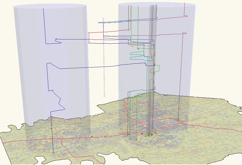
10 An Explicit Representation of Space- Prisms Forward cone/backward cone: the boundary of a prism Represented as a set of spatio-temporal line features Prism Represented as a collection of vertical spatio-temporal line features, which indicate activity opportunities at various locations with explicit information. prism backward cone forward cone
11

12 Network based - prisms forward cone backward cone Space- prism Potential path area Origin Destination


13 Space- life lines for wired access Space- life cylinders for wireless access Extended - prism with wired access Extended - prism with wireless access


14 2005 AAG Annual Meeting Denver receiver initiator A case for potential SP interactions A case for potential AP interactions receiver A case for potential ST interactions initiator A case for potential AT interactions
15 Summary Contributions of this study: Extends - prism concept to represent potential human activities in both physical and virtual s; Develops a spatio-temporal GIS design to accommodate the extended concept by providing functions to compute and visualize - prisms in a 3D GIS environment and to support analysis of spatio-temporal relationships among individuals; and Offers an effective approach of dealing with spatio-temporal, individual activity data in a GIS environment.
Revisiting Hägerstrand s Time-Geographic Framework for Individual Activities in the Age of Instant Access
 Revisiting Hägerstrand s Time-Geographic Framework for Individual Activities in the Age of Instant Access Hongbo Yu Department of Geography, Oklahoma State University, Stillwater, OK 74078, U.S.A. and
Human lives involve various activities
 Spatio-temporal GIS Design for Exploring Interactions of Human Activities Hongbo Yu ABSTRACT: An effective representation of human activities in geographic information systems (GIS) presents a challenging
Representing and Visualizing Travel Diary Data: A Spatio-temporal GIS Approach
 2004 ESRI International User Conference, San Diego, CA Representing and Visualizing Travel Diary Data: A Spatio-temporal GIS Approach Hongbo Yu and Shih-Lung Shaw Abstract Travel diary data (TDD) is an
Space time Prisms, I Wish I Knew How to Quit You
 Space time Prisms, I Wish I Knew How to Quit You Harvey J. Miller Department of Geography and The Ohio State University M: miller.81@osu.edu W: u.osu.edu/miller.81 T: @MobileHarv Time geography- A love
Three-Dimensional Visualization of Activity-Travel Patterns
 C. Rinner 231 Three-Dimensional Visualization of Activity-Travel Patterns Claus Rinner Department of Geography University of Toronto, Canada rinner@geog.utoronto.ca ABSTRACT Geographers have long been
Visualizing and Analyzing Activities in an Integrated Space-time Environment: Temporal GIS Design and Implementation
 Visualizing and Analyzing Activities in an Integrated Space-time Environment: Temporal GIS Design and Implementation Initial Submission on August 1, 2006 Revision on November 15, 2006 Final Submission
Journal of Transport Geography
 Journal of Transport Geography 19 (2011) 422 433 Contents lists available at ScienceDirect Journal of Transport Geography journal homepage: www.elsevier.com/locate/jtrangeo Potential effects of ICT on
HUMAN INTERACTIONS IN PHYSICAL AND VIRTUAL SPACES: A GIS-BASED TIME- GEOGRAPHIC EXPLORATORY APPROACH
 University of Tennessee, Knoxville Trace: Tennessee Research and Creative Exchange Doctoral Dissertations Graduate School 8-2011 HUMAN INTERACTIONS IN PHYSICAL AND VIRTUAL SPACES: A GIS-BASED TIME- GEOGRAPHIC
An Ontology-based Framework for Modeling Movement on a Smart Campus
 An Ontology-based Framework for Modeling Movement on a Smart Campus Junchuan Fan 1, Kathleen Stewart 1 1 Department of Geographical and Sustainability Sciences, University of Iowa, Iowa City, IA, 52242,
SPACE-TIME ACCESSIBILITY MEASURES FOR EVALUATING MOBILITY-RELATED SOCIAL EXCLUSION OF THE ELDERLY
 SPACE-TIME ACCESSIBILITY MEASURES FOR EVALUATING MOBILITY-RELATED SOCIAL EXCLUSION OF THE ELDERLY Izumiyama, Hiroshi Institute of Environmental Studies, The University of Tokyo, Tokyo, Japan Email: izumiyama@ut.t.u-tokyo.ac.jp
Space-adjusting Technologies and the Social Ecologies of Place
 Space-adjusting Technologies and the Social Ecologies of Place Donald G. Janelle University of California, Santa Barbara Reflections on Geographic Information Science Session in Honor of Michael Goodchild
Understanding Individual Daily Activity Space Based on Large Scale Mobile Phone Location Data
 Understanding Individual Daily Activity Space Based on Large Scale Mobile Phone Location Data Yang Xu 1, Shih-Lung Shaw 1 2 *, Ling Yin 3, Ziliang Zhao 1 1 Department of Geography, University of Tennessee,
Spatial Thinking and Modeling of Network-Based Problems
 Spatial Thinking and Modeling of Network-Based Problems Presentation at the SPACE Workshop Columbus, Ohio, July 1, 25 Shih-Lung Shaw Professor Department of Geography University of Tennessee Knoxville,
Space-Time Adjustments to Transportation, Communication, and Information Technologies Social Consequences and Policy Issues
 Space-Time Adjustments to Transportation, Communication, and Information Technologies Social Consequences and Policy Issues Donald G. Janelle Center for Spatially Integrated Social Science University of
Dynamic diurnal social taxonomy of urban environments
 Joint activities with family in Centre County, PA Joint activities with friends in Centre County, PA Dynamic diurnal social taxonomy of urban environments Seo Youn Yoon, Post-doctoral researcher, University
Integrating Origin and Destination (OD) Study into GIS in Support of LIRR Services and Network Improvements
 Study into GIS in Support of LIRR Services and Network Improvements") Integrating Origin and Destination (OD) Study into GIS in Support of LIRR Services and Network Improvements GIS In Transit Conference, Washington, DC Long Island Rail Road Pyung ho Kim Date: September
Integrating Origin and Destination (OD) Study into GIS in Support of LIRR Services and Network Improvements GIS In Transit Conference, Washington, DC Long Island Rail Road Pyung ho Kim Date: September
Grade 6 Social Studies
 Unit Title: Africa : Movement Location Place Human Region : Subject/Course: 6 th Grade Social Studies Essential Questions: peoples, cultures and ideas of the world? How is a location identified using map
Space-time accessibility measures: A geocomputational algorithm with a focus on the feasible opportunity set and possible activity duration
 J Geograph Syst (2003) 5:71 91 Space-time accessibility measures: A geocomputational algorithm with a focus on the feasible opportunity set and possible activity duration Hyun-Mi Kim, Mei-Po Kwan Department
From User Requirements Analysis to Conceptual Design of a Mobile Augmented Reality Tool to be used in an Urban Geography Fieldwork Setting
 From User Requirements Analysis to Conceptual Design of a Mobile Augmented Reality Tool to be used in an Urban Geography Fieldwork Setting Xiaoling Wang, Corné P.J.M. van Elzakker, Menno-Jan Kraak 2016
GIS and Remote Sensing Support for Evacuation Analysis
 GIS and Remote Sensing Support for Evacuation Analysis Presented to GIS for Transportation Symposium Rapid City, South Dakota March 28-31, 2004 Demin Xiong Oak Ridge National Laboratory 2360 Cherahala
Re-imagining Religion: The Spatial Humanities as a Framework for New Scholarship
 2010 Re-imagining Religion: The Spatial Humanities as a Framework for New Scholarship David J. Bodenhamer The Polis Center at IUPUI Virtual Center for Spatial Humanities New Technologies and Interdisciplinary
Activity Identification from GPS Trajectories Using Spatial Temporal POIs Attractiveness
 Activity Identification from GPS Trajectories Using Spatial Temporal POIs Attractiveness Lian Huang, Qingquan Li, Yang Yue State Key Laboratory of Information Engineering in Survey, Mapping and Remote
Smart Data Collection and Real-time Digital Cartography
 Smart Data Collection and Real-time Digital Cartography Yuji Murayama and Ko Ko Lwin Division of Spatial Information Science Faculty of Life and Environmental Sciences University of Tsukuba IGU 2013 1
Grand Challenges in GIScience: UCGIS experiences
 Grand Challenges in GIScience: UCGIS experiences 2006-2010 Tim Nyerges University of Washington University Consortium of Geographic Information Science (UCGIS) AAG Annual Meeting April 17, 2010 Outline
Decentralized Time Geography for Ad-Hoc Collaborative Planning
 Decentralized Time Geography for Ad-Hoc Collaborative Planning Martin Raubal 1, Stephan Winter 2, and Christopher Dorr 1 1 Department of Geography, University of California, Santa Barbara, USA raubal@geog.ucsb.edu;
Daily mobility in Grenoble Metropolitan Region, France. Applied GIS methods in time geographical research
 LUMA-GIS Thesis nr 2 Daily mobility in Grenoble Metropolitan Region, France. Applied GIS methods in time geographical research Rickard Hansen 2008 Dept. of Physical Geography and Ecosystem Analysis Centre
Course Outline. School Name: Keewaytinook Internet High School. Department Name: Canadian and World Studies. Ministry of Education Course Title:
 School Name: Keewaytinook Internet High School Department Name: Canadian and World Studies Course Outline Ministry of Education Course Title: Travel and Tourism: A Geographic Perspective Grade Level: 11
GeoTrans Lab. Department of Geography Santa Barbara, CA 93106, USA Phone: , Fax: *Corresponding Author
 Feasibility of using time-space prism to represent available opportunities and choice sets for destination choice models in the context of dynamic urban environments Seo Youn Yoon* [yoon@geog.ucsb.edu]
Urban Geo-Informatics John W Z Shi
 Urban Geo-Informatics John W Z Shi Urban Geo-Informatics studies the regularity, structure, behavior and interaction of natural and artificial systems in the urban context, aiming at improving the living
5.3 Transportation and Communication Lifeline Disruption Harvey J. Miller Department of Geography University of Utah
 5.3 Transportation and Communication Lifeline Disruption Harvey J. Miller Department of Geography University of Utah S. L. Cutter, D. B. Richardson and T. Wilbanks (eds.) The Geographic Dimensions of Terrorism,
A General Framework for Conflation
 A General Framework for Conflation Benjamin Adams, Linna Li, Martin Raubal, Michael F. Goodchild University of California, Santa Barbara, CA, USA Email: badams@cs.ucsb.edu, linna@geog.ucsb.edu, raubal@geog.ucsb.edu,
The Importance of Spatial Literacy
 The Importance of Spatial Literacy Dr. Michael Phoenix GIS Education Consultant Taiwan, 2009 What is Spatial Literacy? Spatial Literacy is the ability to be able to include the spatial dimension in our
Cartography and Children Commission: Proposals for the next 4 years
 International Cartographic Association Cartography and Children Commission: Proposals for the next 4 years José Jesús Reyes Nuñez Eötvös Loránd University Dept. of Cartography and Geoinformatics Budapest,
https://u.osu.edu/miller.81/ Texts 1. Required Worboys, M. and Duckham, M. (2004) GIS: A Computing Perspective. Other readings see course schedule.
 GIS: A Computing Perspective. Other readings see course schedule.") GEOGR 5212 Geospatial Databases for GIS - Spring Instructor Harvey J. Miller Lecture/lab meeting time Tuesdays 3:55PM - 5:15PM, Denney Hall 238 and location (classroom) Thursdays 3:55PM - 5:15PM Derby
GEOGR 5212 Geospatial Databases for GIS - Spring Instructor Harvey J. Miller Lecture/lab meeting time Tuesdays 3:55PM - 5:15PM, Denney Hall 238 and location (classroom) Thursdays 3:55PM - 5:15PM Derby
Cognitive Engineering for Geographic Information Science
 Cognitive Engineering for Geographic Information Science Martin Raubal Department of Geography, UCSB raubal@geog.ucsb.edu 21 Jan 2009 ThinkSpatial, UCSB 1 GIScience Motivation systematic study of all aspects
Determining Social Constraints in Time Geography through Online Social Networking
 Determining Social Constraints in Time Geography through Online Social Networking Grant McKenzie a a Department of Geography, University of California, Santa Barbara (grant.mckenzie@geog.ucsb.edu) Advisor:
Exploring Kimberley Bushfires in Space and Time
 Exploring Kimberley Bushfires in Space and Time Ulanbek Turdukulov and Tristan Fazio Department of Spatial Sciences, Curtin University, Bentley, WA, Australia; Emails: ulanbek.turdukulov@curtin.edu.au
Modelling Accessibility to General Hospitals in Ireland
 Modelling Accessibility to General Hospitals in Ireland Stamatis Kalogirou 1,*, Ronan Foley 2 1. National Centre for Geocomputation, John Hume Building, NUI Maynooth, Maynooth, Co. Kildare, Ireland, Tel:
Spatio-temporal Approaches to Understanding Human Behavior and Social Organization
 Spatio-temporal Approaches to Understanding Human Behavior and Social Organization Don Janelle Center for Spatially Integrated Social Science Center for Spatial Studies University of California, Santa
Assessment Schedule 2014 Geography: Demonstrate understanding of how interacting natural processes shape a New Zealand geographic environment (91426)
") NCEA Level 3 Geography (91426) 2014 page 1 of 5 Assessment Schedule 2014 Geography: Demonstrate understanding of how interacting natural processes shape a New Zealand geographic environment (91426) Evidence
NCEA Level 3 Geography (91426) 2014 page 1 of 5 Assessment Schedule 2014 Geography: Demonstrate understanding of how interacting natural processes shape a New Zealand geographic environment (91426) Evidence
Using Volunteer Tracking Information for Activity- Based Travel Demand Modeling and Finding Dynamic Interaction-Based Joint-Activity Opportunities
 University of Tennessee, Knoxville Trace: Tennessee Research and Creative Exchange Masters Theses Graduate School 5-2011 Using Volunteer Tracking Information for Activity- Based Travel Demand Modeling
Indiana University Maps
 Indiana University 9.28.09 Maps Maps Mission Action Cause related cartography at National Geographic Networks and Complex Systems This talk series is open to all Indiana University faculty and students
Big Data Discovery and Visualisation Insights for ArcGIS
 Big Data Discovery and Visualisation Insights for ArcGIS Create Enrich - Collaborate Lee Kum Cheong GIS CONVERSATIONS At Esri, we believe people can do amazing things with applied geography. GIS CONVERSATIONS
GOVERNMENT GIS BUILDING BASED ON THE THEORY OF INFORMATION ARCHITECTURE
 GOVERNMENT GIS BUILDING BASED ON THE THEORY OF INFORMATION ARCHITECTURE Abstract SHI Lihong 1 LI Haiyong 1,2 LIU Jiping 1 LI Bin 1 1 Chinese Academy Surveying and Mapping, Beijing, China, 100039 2 Liaoning
geographic patterns and processes are captured and represented using computer technologies
 Proposed Certificate in Geographic Information Science Department of Geographical and Sustainability Sciences Submitted: November 9, 2016 Geographic information systems (GIS) capture the complex spatial
for an Informed Analysis of A Socio-Economic Perspective Adrijana Car, Marike Bontenbal and Marius Herrmann
 Creating a GIS-Base for an Informed Analysis of Tourism Development: A Socio-Economic Perspective Adrijana Car, Marike Bontenbal and Marius Herrmann adrijana.car@gutech.edu.om edu GSS 2012 Affiliated to:
Curriculum Vitae. Ran Wei
 Curriculum Vitae Ran Wei Contact Information Mailing Address: Department of Geography University of Utah 260 S. Central Campus Dr., Rm. 270 Salt Lake City, UT 84112-9155, USA Phone: 1-801-581-8730 Email:
What is GIS? ESRI Canada. August 2011
 What is GIS? ESRI Canada August 2011 Geography Matters! Environmental Park Management Agriculture Public Utilities Health Care Emergency 911 Real Estate Marketing Environmental What are the effects of
Joanne N. Halls, PhD Dept. of Geography & Geology David Kirk Information Technology Services
 Joanne N. Halls, PhD Dept. of Geography & Geology David Kirk Information Technology Services Geographic Information Systems manage and analyze data to solve spatial problems. Real World Abstraction Analysis
Lecture 1: Geospatial Data Models
 Lecture 1: GEOG413/613 Dr. Anthony Jjumba Introduction Course Outline Journal Article Review Projects (and short presentations) Final Exam (April 3) Participation in class discussions Geog413/Geog613 A
GIScience & Mobility. Prof. Dr. Martin Raubal. Institute of Cartography and Geoinformation SAGEO 2013 Brest, France
 GIScience & Mobility Prof. Dr. Martin Raubal Institute of Cartography and Geoinformation mraubal@ethz.ch SAGEO 2013 Brest, France 25.09.2013 1 www.woodsbagot.com 25.09.2013 2 GIScience & Mobility Modeling
Advanced Algorithms for Geographic Information Systems CPSC 695
 Advanced Algorithms for Geographic Information Systems CPSC 695 Think about Geography What is Geography The 3 W s of Geography What is where Why is it there Why do I care Data - Data - Data We all got
GEOG 105 THE DIGITAL EARTH Spring 2017
 GEOG 105 THE DIGITAL EARTH Spring 2017 Instructor: Dr. Julie Cidell E-mail: jcidell@illinois.edu Office: CAB 251 (244-4665) Office hours: W 1:30-3:30 or by appt. TA: Donald Planey TA E-mail: planey1@illinois.edu
Using 3D Geographic Information System to Improve Sales Comparison Approach for Real Estate Valuation
 XXV FIG Congress, Kuala Lumpur, Malaysia TS02E-3D Using 3D Geographic Information System to Improve Sales Comparison Approach for Real Estate Valuation Haicong Yu Center for Assessment and Development
Influence of Information Technology on Social Spatial Behaviors of Urban Residents Case of Nanjing City in China
 Chin. Geogra. Sci. 2008 18(4) 316 322 DOI: 10.1007/s11769-008-0316-x www.springerlink.com Influence of Information Technology on Social Spatial Behaviors of Urban Residents Case of Nanjing City in China
The use of modern sources of information in shaping the geographic literacy of Russian school students
 Journal of Subject Didactics, 2017 Vol. 2, No. 2, 67-71, DOI: 10.5281/zenodo.1239720 Short Review The use of modern sources of information in shaping the geographic literacy of Russian school students
Spatial Analysis and Modeling (GIST 4302/5302) Guofeng Cao Department of Geosciences Texas Tech University
 Guofeng Cao Department of Geosciences Texas Tech University") Spatial Analysis and Modeling (GIST 4302/5302) Guofeng Cao Department of Geosciences Texas Tech University TTU Graduate Certificate Geographic Information Science and Technology (GIST) 3 Core Courses and
Spatial Analysis and Modeling (GIST 4302/5302) Guofeng Cao Department of Geosciences Texas Tech University TTU Graduate Certificate Geographic Information Science and Technology (GIST) 3 Core Courses and
REAL-TIME GIS OF GENDER
 2 nd Conference on Advanced Modeling and Analysis MOPT/IGOT/CEG REAL-TIME GIS OF GENDER A telegeomonitoring approach PT07 Mainstreaming Gender Equality and Promoting Work Life Balance (2nd Open Call -
OPTIMAL ALLOCATION OF EMERGENCY SHELTER FACILITIES IN BEIJING. WU Wen-jie 1,2, ZHU Si-yuan 1,2 ZHANG Wen-zhong 1
 2010 4 114 :1003-2398(2010)04-0041-04 1,2 1,2 1,, (1., 100101;2., 100039) OPTIMAL ALLOCATION OF EMERGENCY SHELTER FACILITIES IN BEIJING WU Wen-jie 1,2, ZHU Si-yuan 1,2 ZHANG Wen-zhong 1 (1.Institute of
The Next Generation of Traffic Management Systems
 AASHTO CTSO ITS Working Group Meeting The Next Generation of Traffic Management Systems What Resources Do Agencies Need & Is There Interest to Collaborate With TRB Technical Committees & Other Groups?
Sensitivity of estimates of travel distance and travel time to street network data quality
 Sensitivity of estimates of travel distance and travel time to street network data quality Paul Zandbergen Department of Geography University of New Mexico Outline Street network quality Approaches to
Leilei Duan. Spatial Science Institute University of Southern California Los Angeles, CA 90089
 Leilei Duan Spatial Science Institute University of Southern California Los Angeles, CA 90089 Email: leileidu@usc.edu Web resume: https://goo.gl/btwwip Phone: +1 352 213 3511 EDUCATION Post-doc Teaching
Agile Mind Mathematics 8 Scope and Sequence, Texas Essential Knowledge and Skills for Mathematics
 Agile Mind Mathematics 8 Scope and Sequence, 2014-2015 Prior to Grade 8, students have written and interpreted expressions, solved equations and inequalities, explored quantitative relationships between
Qualitative Spatio-Temporal Reasoning & Spatial Database Design
 Qualitative Spatio-Temporal Reasoning Focus on 2 research topics at the of the University of Liège J-P. Donnay P. Hallot F. Laplanche Curriculum in «Surveying & Geomatics» in the Faculty of Sciences of
GIS Based Transit Information System for Metropolitan Cities in India
 PAPER REFERENCE NO.: PN-250 GIS Based Transit Information System for Metropolitan Cities in India Pal, Sarvjeet. a and Singh, Varun. b a M. Tech. (GIS & Remote Sensing); GIS Cell; Motilal Nehru National
International Journal of Computing and Business Research (IJCBR) ISSN (Online) : APPLICATION OF GIS IN HEALTHCARE MANAGEMENT
 ISSN (Online) : APPLICATION OF GIS IN HEALTHCARE MANAGEMENT") International Journal of Computing and Business Research (IJCBR) ISSN (Online) : 2229-6166 Volume 3 Issue 2 May 2012 APPLICATION OF GIS IN HEALTHCARE MANAGEMENT Dr. Ram Shukla, Faculty (Operations Area),
International Journal of Computing and Business Research (IJCBR) ISSN (Online) : 2229-6166 Volume 3 Issue 2 May 2012 APPLICATION OF GIS IN HEALTHCARE MANAGEMENT Dr. Ram Shukla, Faculty (Operations Area),
Introduction to Geographic Information Systems Dr. Arun K Saraf Department of Earth Sciences Indian Institute of Technology, Roorkee
 Introduction to Geographic Information Systems Dr. Arun K Saraf Department of Earth Sciences Indian Institute of Technology, Roorkee Lecture 01 What is Geographic Information Systems? I welcome to this
CAWa Central Asian Water. Training Course Geographical Information Systems in Hydrology
 CAWa Central Asian Water Training Course Geographical Information Systems in Hydrology 1 Place & Time Place to hold the workshop: Helmholtz Centre Potsdam GFZ German Research Center for Geosciences, Germany
Cartographic and Geospatial Futures
 Cartographic and Geospatial Futures 1. Web Cartography, WebGIS, & Virtual Globes--New Roles for Maps, GIS, and GIS professionals 2. Map Mashups, the Neo Neo-geography Movement, & Crowd-sourcing Geospatial
Key Issue #1. How do geographers describe where things are? 2014 Pearson Education, Inc.
 Key Issue #1 How do geographers describe where things are? Learning Outcomes 1.1.1: Explain differences between early maps and contemporary maps. 1.1.2: Describe the role of map scale and projections and
Animating Maps: Visual Analytics meets Geoweb 2.0
 Animating Maps: Visual Analytics meets Geoweb 2.0 Piyush Yadav 1, Shailesh Deshpande 1, Raja Sengupta 2 1 Tata Research Development and Design Centre, Pune (India) Email: {piyush.yadav1, shailesh.deshpande}@tcs.com
Mobile GIS Application for Khartoum Public Transportation Network
 Mobile GIS Application for Khartoum Public Transportation Network Mohammed Mahmoud Ibrahim (1) -Department of GIS and Remote Sensing, Faculty of Geoinformatics -Future University of Sudan -Khartoum, Sudan-mohammed.aau@gmail.com
of places Key stage 1 Key stage 2 describe places
 Unit 25 Geography and numbers ABOUT THE UNIT This continuous unit aims to show how geographical enquiry can provide a meaningful context for the teaching and reinforcement of many aspects of the framework
Spatial Web Technology for Urban Green Society (A Case of Tsukuba City)
") The 5th Japan-Korea-China Joint Conference on Geography (Green Society in East Asia: A Geographical Contribution) Spatial Web Technology for Urban Green Society (A Case of Tsukuba City) Ko Ko Lwin and
The 5th Japan-Korea-China Joint Conference on Geography (Green Society in East Asia: A Geographical Contribution) Spatial Web Technology for Urban Green Society (A Case of Tsukuba City) Ko Ko Lwin and
Determinants of the structural dimension of daily behaviour in a traditional African City: A case study of Ilorin, Nigeria
 15 Determinants of the structural dimension of daily behaviour in a traditional African City: A case study of Ilorin, Nigeria Adedokun Olutoyin Moses 1 1 Department of Geography, Federal College of Education,
Supporting the reconfiguration of primary care services: Strategic Health Asset Planning and Evaluation
 Supporting the reconfiguration of primary care services: Strategic Health Asset Planning and Evaluation About SHAPE Strategic Health Asset Planning and Evaluation (SHAPE) is a web enabled, evidence based
Online visualization of multi-dimensional spatiotemporal
 Online visualization of multi-dimensional spatiotemporal data Visualization of weather data of Germany in a large time scale Keni Han Final presentation Supervisor: Dr.-Ing. Mathias Jahnke Univ.Prof. Mag.rer.nat.
Introduction. Thematic Mapping for Disaster Risk Assessment in Case of Earthquake FIG Working Week
 Thematic Mapping for Disaster Risk Assessment in Case of Earthquake Silvia MARINOVA, Temenoujka BANDROVA, Mihaela KOUTEVA-GUENTCHEVA, Stefan BONCHEV University of Architecture, Civil Engineering and Geodesy
SDI Standards at work
 SDI Standards at work Jan Juul Jensen Senior Technology Strategist Informi GIS Denmark Informi GIS Private held Limited Company Specialized in GIS 100+ employees HQ in Charlottenlund, Copenhagen Regional
Ying Song. Assistant Professor, Department of Geography, Environment and Society Faculty Member, Center for Transportation Studies (CTS)
") Ying Song Department of Geography, Environment and Society University of Minnesota, Twin Cities 478 Social Science, 267-19th Avenue South Minneapolis, MN 55455, USA Office: +1.612.625.2056 Fax: +1.612.624.1044
Ying Song Department of Geography, Environment and Society University of Minnesota, Twin Cities 478 Social Science, 267-19th Avenue South Minneapolis, MN 55455, USA Office: +1.612.625.2056 Fax: +1.612.624.1044
Abstract. Interoperable Framework for Mobile Dynamic Surveying based on open source components
 Interoperable Framework for Mobile Dynamic Surveying based on open source components Sergiusz Pawlowicz, Didier Leibovici, Richard Saull±, Mike Jackson, Chaoyu Ye, Wenchao Jiang, Natalie Adams 1, Suchith
ENV208/ENV508 Applied GIS. Week 1: What is GIS?
 ENV208/ENV508 Applied GIS Week 1: What is GIS? 1 WHAT IS GIS? A GIS integrates hardware, software, and data for capturing, managing, analyzing, and displaying all forms of geographically referenced information.
1. INTRODUCTION 2. BIG DATA IN URBAN STUDIES 3. LESSONS FROM BIG DATA
 Main Content URBAN SENSING & COMPUTING Sensing and Computing Introduction and Application 王江浩 State Key Laboratory of Resources and Environmental Information System, Institute of Geographic Sciences and
A Land Use Transport Model for Greater London:
 Spatio-Temporal Analysis of Network Data and Road Developments Launch Event Workshop UCL Monday 18 May 2009 A Land Use Transport Model for Greater London: With Applications to an Integrated Assessment
Cartographic Workshop
 http://lazarus.elte.hu/cet/ Cartographic Workshop One of the roles of the ICA, Commission on Education and Training is to provide member nations with cartographic workshop experiences that enhance the
Research Seminar on Urban Information Systems
 11.522 Research Seminar on Urban Information Systems Instructor: Joe Ferreira, jf@mit.edu Monday, 6-8 PM in Room 9-451 Opportunity for students to build on basic skills in GIS and urban analytics in order
The Role of Geography in Social Networks: CouchSurfing as a Case Study
 University of California Transportation Center UCTC Dissertation UCTC-DISS-2011-06 The Role of Geography in Social Networks: CouchSurfing as a Case Study Edward Pultar University of California, Santa Barbara
The Concept of Geographic Relevance
 The Concept of Geographic Relevance Tumasch Reichenbacher, Stefano De Sabbata, Paul Crease University of Zurich Winterthurerstr. 190 8057 Zurich, Switzerland Keywords Geographic relevance, context INTRODUCTION
Interactive GIS in Veterinary Epidemiology Technology & Application in a Veterinary Diagnostic Lab
 Interactive GIS in Veterinary Epidemiology Technology & Application in a Veterinary Diagnostic Lab Basics GIS = Geographic Information System A GIS integrates hardware, software and data for capturing,
Course overview. Grading and Evaluation. Final project. Where and When? Welcome to REM402 Applied Spatial Analysis in Natural Resources.
 Welcome to REM402 Applied Spatial Analysis in Natural Resources Eva Strand, University of Idaho Map of the Pacific Northwest from http://www.or.blm.gov/gis/ Where and When? Lectures Monday & Wednesday
Introduction to GIS. Geol 4048 Geological Applications of Remote Sensing
 Introduction to GIS Geol 4048 Geological Applications of Remote Sensing GIS History: Before Computers GIS History Using maps for a long time Dr. Roger F. Tomlinson Father of GIS He was an English geographer
BIOGRAPHY INTRODUCTION
 VISUAL DATA MINING: BUILDING 'SPACE-TIME-CUBE' SOCIO-ECONOMIC CONDUITS FOR PROVINCIAL LEVEL MODELLING OF THE REGIONAL DEVELOPMENT PROCESS IN SPAIN 1955-1977 ROBERT J. ABRAHART AND ROY P. BRADSHAW School
MONITORING LOGISTICS OPERATIONS OF THE FOREST BASED SUPPLY CHAIN IN (NEAR) REAL-TIME UTILIZING HARMONIZATION APPROACHES: a Case Study from Austria
 REAL-TIME UTILIZING HARMONIZATION APPROACHES: a Case Study from Austria") MONITORING LOGISTICS OPERATIONS OF THE FOREST BASED SUPPLY CHAIN IN (NEAR) REAL-TIME UTILIZING HARMONIZATION APPROACHES: a Case Study from Austria Johannes Scholz 1 Manfred Mittlboeck 2 Ralph Jank 2 1
MONITORING LOGISTICS OPERATIONS OF THE FOREST BASED SUPPLY CHAIN IN (NEAR) REAL-TIME UTILIZING HARMONIZATION APPROACHES: a Case Study from Austria Johannes Scholz 1 Manfred Mittlboeck 2 Ralph Jank 2 1
Map Collections and the Internet: Some Ideas about Various Online Map Services, Based on the ETH Map Collection in Zürich
 LIBER QUARTERLY, ISSN 1435-5205 LIBER 2000. All rights reserved K.G. Saur, Munich. Printed in Germany Map Collections and the Internet: Some Ideas about Various Online Map Services, Based on the ETH Map
Data-Sharing Agreement
 Data-Sharing Agreement Contributions to LandMark: The Global Platform of Indigenous and Community Lands This Data-Sharing Agreement provides the standards for contributing data to the LandMark: The Global
Research on the Architecture of Urban Emergency System Based on GIS Zhe Li1,a, Xiang Teng2,b
 3rd International Conference on Materials Engineering, Manufacturing Technology and Control (ICMEMTC 2016) Research on the Architecture of Urban Emergency System Based on GIS Zhe Li1,a, Xiang Teng2,b 1
THE USE OF GEOSPATIAL DATA TO SUPPORT VULNERABILITY MAPPING OF THE OREGON COAST. Kelvin Raiford MS Candidate Geography Department of Geosciences
 THE USE OF GEOSPATIAL DATA TO SUPPORT VULNERABILITY MAPPING OF THE OREGON COAST Kelvin Raiford MS Candidate Geography Department of Geosciences INTRODUCTION This study is an outcome of the project Geospatial
Tao Tang and Jiazhen Zhang Department of Geography and Planning, and the Great Lakes Research Center State University of New York Buffalo State
 Tao Tang and Jiazhen Zhang Department of Geography and Planning, and the Great Lakes Research Center State University of New York Buffalo State College 1300 Elmwood Ave., Buffalo, NY 14222-1095 Email:
2015 Copyright Board of Studies, Teaching and Educational Standards NSW for and on behalf of the Crown in right of the State of New South Wales.
 2015 Copyright Board of Studies, Teaching and Educational Standards NSW for and on behalf of the Crown in right of the State of New South Wales. This document contains Material prepared by the Board of
EXPLORATORY RESEARCH ON DYNAMIC VISUALIZATION BASED ON SPATIO-TEMPORAL DATABASE
 EXPLORATORY RESEARCH ON DYNAMIC VISUALIZATION BASED ON SPATIO-TEMPORAL DATABASE Yang ping a, b, Tang Xinming b, c, Lei Bing b, Zhai Liang a,b, Tian Jiaojiao d a School of Resource and Environment Science,