Network Analysis Services in ArcGIS Enterprise. Deelesh Mandloi
|
|
|
- Stephen Gibbs
- 6 years ago
- Views:
Transcription


1 Network Analysis Services in ArcGIS Enterprise Deelesh Mandloi

2 Slides from this demo theater
3 Agenda Network Analyst concepts ArcGIS Enterprise publishing workflow - Geoprocessing services - Network Analysis services Using network analysis services
4 Network Analyst Concepts

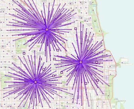
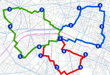
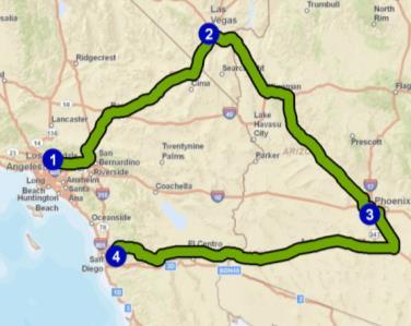
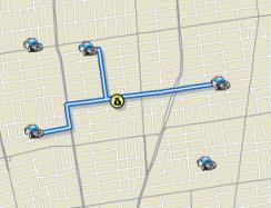
5 ArcGIS Network Analyst Solve Transportation Problems Route Closest Facility Service Area Vehicle Routing Problem Location-Allocation Origin-Destination Cost Matrix


6 Analysis is performed on a network dataset Network Dataset Data Model Transportation Network Geodatabase


7 Where do I get a network dataset? Purchase StreetMap Premium for ArcGIS - High quality ready-to-use network dataset - Can add your own street data as well OR Build your own network dataset from: - Your organization s data - TIGER - OpenStreetMap (try ArcGIS Editor for OpenStreetMap)
8 ArcGIS Enterprise

9 What is ArcGIS Enterprise? Apps Enables Web GIS in your infrastructure - On-premises or in your own cloud Formerly known as ArcGIS for Server Portal GIS Server with Routing Services Network Dataset


10 What are GIS services? GIS service GIS resource running on a server - vs. GIS application on your local computer services Share GIS resources to the web Map Feature Network Geodata Geoprocessing Image Locator Schematics

11 Publishing workflow for GIS services Author Publish Share/Use


12 Publishing network analysis services Can be published as two different service types Geoprocessing Service 1. Author using geoprocessing tools from the Server toolset 2. Run the tools and publish the result as a service 3. Use from Map Viewer, ArcGIS Pro and ArcMap Network Analysis Service 1. Author using a map document with network analysis layers Publish the map document as a service 3. Use from Map Viewer and ArcMap (Route solver only) 3
13 Geoprocessing or network analysis services? Choosing the correct service type Both geoprocessing and network analysis service support the full network analysis capabilities Select geoprocessing service if Analysis runs for long duration (greater than 60 seconds) Out-of-the box app support is important Network analysis is just one part of a larger analysis Need to access the traversal result for further analysis Need to access OD Cost Matrix, Vehicle Routing Problem, or Location Allocation Solvers from REST based Web APIs Select network analysis service if Analysis runs for short duration (less than 60 seconds) Need very fast execution
14 Publishing Services


15 Single tool to publish all network analysis services I have a network dataset and want to publish all network analysis services. Is there a single tool that can perform the authoring and publishing of these services?
16 Publish Routing Services tool Setup instructions and tool available on GitHub Requires ArcMap and Network Analyst extension to publish services If publishing to a federated GIS Server, the tool registers the network analysis services as portal utility services New at 10.5: Use any network dataset and not just StreetMap Premium

17 Services created by publish routing services tool Asynchronous geoprocessing service Network analysis service Synchronous geoprocessing service Service to get travel modes

18 Registering services with your portal Configure as Directions and Routing utility services in your portal Allows all apps to discover the network analysis services Required by many apps in order to use the services Configured by Publish Routing Services tool if publishing services to a federated GIS Server

19 Using Services Map Viewer, ArcGIS Pro, and ArcMap

20 Using services in Map Viewer Directions button Analysis tools - Most tools in the Use Proximity toolset - Choose Best Facilities tool in Find Locations toolset - Summarize Nearby tool in Summarize Data toolset


21 Using services in ArcGIS Desktop Use from Network Analysis gallery in the Analysis tab within ArcGIS Pro Use from a ArcGIS Server connection in ArcMap


22 Demo Publish and use network analysis services


23 Please Take Our Survey on the Esri Events App! Download the Esri Events app and find your event Select the session you attended Scroll down to find the survey Complete Answers and Select Submit
24 Questions? Slides from this demo theater


25
ArcGIS Online Routing and Network Analysis. Deelesh Mandloi Matt Crowder
 ArcGIS Online Routing and Network Analysis Deelesh Mandloi Matt Crowder Introductions Who are we? - Members of the Network Analyst development team Who are you? - Network Analyst users? - ArcGIS Online
Network Analysis with ArcGIS Online. Deelesh Mandloi Dmitry Kudinov
 Deelesh Mandloi Dmitry Kudinov Introductions Who are we? - Network Analyst Product Engineers Who are you? - Network Analyst users? - ArcGIS Online users? - Trying to figure out what is ArcGIS Online? Slides
ArcGIS Pipeline Referencing An Introduction. Anjali Bhangay William Isley
 ArcGIS Pipeline Referencing An Introduction Anjali Bhangay William Isley Pipeline Referencing Overview Information Model Pipeline Referencing Overview Information Model ArcGIS Pro Pipeline Referencing
ArcGIS Data Reviewer: Quality Assessment for Elevation Raster Datasets. Roslyn Dunn
 ArcGIS Data Reviewer: Quality Assessment for Elevation Raster Datasets Roslyn Dunn What is ArcGIS Data Reviewer? Data Quality Management for ArcGIS Provides - Rule-based validation - Interactive tools
ArcGIS Enterprise: What s New. Philip Heede Shannon Kalisky Melanie Summers Sam Williamson
 ArcGIS Enterprise: What s New Philip Heede Shannon Kalisky Melanie Summers Sam Williamson ArcGIS Enterprise is the new name for ArcGIS for Server What is ArcGIS Enterprise ArcGIS Enterprise is powerful
Introduction to ArcGIS Maps for Office. Greg Ponto Scott Ball
 Introduction to ArcGIS Maps for Office Greg Ponto Scott Ball Agenda What is Maps for Office? Platform overview What are Apps for the Office? ArcGIS Maps for Office features - Visualization - Geoenrichment
ArcGIS Runtime: Migrating Your Apps from ArcGIS Engine. Eric Bader Lucas Danzinger Mike Branscomb
 ArcGIS Runtime: Migrating Your Apps from ArcGIS Engine Eric Bader Lucas Danzinger Mike Branscomb Migrating to ArcGIS Runtime ArcGIS Engine ArcGIS Runtime AppStudio for ArcGIS Apps: Collector, Workforce,
Demystifying ArcGIS Online. Karen Lizcano Esri
 Demystifying ArcGIS Online Karen Lizcano Esri An Integrated Web GIS Platform Desktop Web Device Powered by Services Managed via Portal Access from any Device Portal Server Online Content and Services ArcGIS
ArcGIS Pro: Analysis and Geoprocessing. Nicholas M. Giner Esri Christopher Gabris Blue Raster
 ArcGIS Pro: Analysis and Geoprocessing Nicholas M. Giner Esri Christopher Gabris Blue Raster Agenda What is Analysis and Geoprocessing? Analysis in ArcGIS Pro - 2D (Spatial xy) - 3D (Elevation - z) - 4D
Introduction to Portal for ArcGIS. Hao LEE November 12, 2015
 Introduction to Portal for ArcGIS Hao LEE November 12, 2015 Agenda Web GIS pattern Product overview Installation and deployment Security and groups Configuration options Portal for ArcGIS + ArcGIS for
ArcGIS Data Reviewer: Assessing Positional Accuracy. Roslyn Dunn
 ArcGIS Data Reviewer: Assessing Positional Accuracy Roslyn Dunn What is ArcGIS Data Reviewer? Data Quality Management for ArcGIS Provides - Rule-based validation - Interactive tools - Track errors Validate
Portal for ArcGIS: An Introduction. Catherine Hynes and Derek Law
 Portal for ArcGIS: An Introduction Catherine Hynes and Derek Law Agenda Web GIS pattern Product overview Installation and deployment Configuration options Security options and groups Portal for ArcGIS
ArcGIS Online Analytics. Mike Flanagan
 ArcGIS Online Analytics Mike Flanagan MFlanagan@esri.com Agenda Introduction to ArcGIS Online Spatial Analysis ArcGIS Online Spatial Analysis Workflow Demos and Examples Wrap-up Q&A ArcGIS A complete web
Enabling Web GIS. Dal Hunter Jeff Shaner
 Enabling Web GIS Dal Hunter Jeff Shaner Enabling Web GIS In Your Infrastructure Agenda Quick Overview Web GIS Deployment Server GIS Deployment Security and Identity Management Web GIS Operations Web GIS
An introduction to ArcGIS Maps for Office. Scott Ball & Mike Flanagan
 An introduction to ArcGIS Maps for Office Scott Ball & Mike Flanagan Main takeaways for today Adding the where to your analysis You can learn a lot when you unlock the power of geography in your analytics
Getting Started with Community Maps
 Esri International User Conference San Diego, California Technical Workshops July 24, 2012 Getting Started with Community Maps Shane Matthews and Tamara Yoder Topics for this Session ArcGIS is a complete
Esri Production Mapping: Map Automation & Advanced Cartography MADHURA PHATERPEKAR JOE SHEFFIELD
 Esri Production Mapping: Map Automation & Advanced Cartography MADHURA PHATERPEKAR JOE SHEFFIELD Traditional Cartography What you really want Cartographic Workflow Output Cartographic Data Symbology Layout
ArcGIS. for Server. Understanding our World
 ArcGIS for Server Understanding our World ArcGIS for Server Create, Distribute, and Manage GIS Services You can use ArcGIS for Server to create services from your mapping and geographic information system
Data Aggregation with InfraWorks and ArcGIS for Visualization, Analysis, and Planning
 Data Aggregation with InfraWorks and ArcGIS for Visualization, Analysis, and Planning Stephen Brockwell President, Brockwell IT Consulting, Inc. Join the conversation #AU2017 KEYWORD Class Summary Silos
ArcGIS Enterprise: What s New. Philip Heede Shannon Kalisky Melanie Summers Shreyas Shinde
 ArcGIS Enterprise: What s New Philip Heede Shannon Kalisky Melanie Summers Shreyas Shinde ArcGIS Enterprise is the new name for ArcGIS for Server ArcGIS Enterprise Software Components ArcGIS Server Portal
Introduction to Portal for ArcGIS
 Introduction to Portal for ArcGIS Derek Law Product Management March 10 th, 2015 Esri Developer Summit 2015 Agenda Web GIS pattern Product overview Installation and deployment Security and groups Configuration
Portal for ArcGIS: An Introduction
 Portal for ArcGIS: An Introduction Derek Law Esri Product Management Esri UC 2014 Technical Workshop Agenda Web GIS pattern Product overview Installation and deployment Security and groups Configuration
Web GIS Deployment for Administrators. Vanessa Ramirez Solution Engineer, Natural Resources, Esri
 Web GIS Deployment for Administrators Vanessa Ramirez Solution Engineer, Natural Resources, Esri Agenda Web GIS Concepts Web GIS Deployment Patterns Components of an On-Premises Web GIS Federation of Server
OFWIM 2017 Annual Conference What Does Web GIS Really Mean for Fish and Wildlife Agencies?
 Content Open Mapping OFWIM 2017 Annual Conference What Does Web GIS Really Mean for Fish and Wildlife Agencies? Imagery Spatial Analysis Mike Bialousz, Esri 3D Data Exploration Real-Time Apps Visualization
Troubleshooting Replication and Geodata Services. Liz Parrish & Ben Lin
 Troubleshooting Replication and Geodata Services Liz Parrish & Ben Lin AGENDA: Troubleshooting Replication and Geodata Services Overview Demo Troubleshooting Q & A Overview of Replication Liz Parrish What
Introduction to ArcGIS Server Development
 Introduction to ArcGIS Server Development Kevin Deege,, Rob Burke, Kelly Hutchins, and Sathya Prasad ESRI Developer Summit 2008 1 Schedule Introduction to ArcGIS Server Rob and Kevin Questions Break 2:15
ArcGIS Runtime: Migrating from ArcGIS Engine. Rex Hansen
 ArcGIS Runtime: Migrating from ArcGIS Engine Rex Hansen Thank You to Our Sponsors Migrating from ArcGIS Engine to ArcGIS Runtime ArcGIS Runtime API: new and evolved workflows on all platforms Windows Linux
Administering your Enterprise Geodatabase using Python. Jill Penney
 Administering your Enterprise Geodatabase using Python Jill Penney Assumptions Basic knowledge of python Basic knowledge enterprise geodatabases and workflows You want code Please turn off or silence cell
What Would John Snow Do (Today)? Part 1
? Part 1") What Would John Snow Do (Today)? Part 1 Tanya Bigos and Derek Law @Tanyabigos @GIS_Bandit Thurs Oct 19 th, 2017 Outline Overview of the ArcGIS Platform Whiteboard discussion Summary Questions A Whole New
What Would John Snow Do (Today)? Part 1 Tanya Bigos and Derek Law @Tanyabigos @GIS_Bandit Thurs Oct 19 th, 2017 Outline Overview of the ArcGIS Platform Whiteboard discussion Summary Questions A Whole New
ArcGIS GeoAnalytics Server: An Introduction. Sarah Ambrose and Ravi Narayanan
 ArcGIS GeoAnalytics Server: An Introduction Sarah Ambrose and Ravi Narayanan Overview Introduction Demos Analysis Concepts using GeoAnalytics Server GeoAnalytics Data Sources GeoAnalytics Server Administration
Administering Your Enterprise Geodatabase using Python. Gerhard Trichtl
 Administering Your Enterprise Geodatabase using Python Gerhard Trichtl What is the Geodatabase What is the Geodatabase A physical store of geographic data - Scalable storage model supported on different
Migrating Defense Workflows from ArcMap to ArcGIS Pro. Renee Bernstein and Jared Sellers
 Migrating Defense Workflows from ArcMap to ArcGIS Pro Renee Bernstein and Jared Sellers ArcGIS Desktop Desktop Web Device ArcMap ArcCatalog ArcScene ArcGlobe ArcGIS Pro portal Server Online Content and
Spatial Analysis with Web GIS. Rachel Weeden
 Spatial Analysis with Web GIS Rachel Weeden Agenda Subhead goes here Introducing ArcGIS Online Spatial Analysis Workflows Scenarios Other Options Resources ArcGIS is a Platform Making mapping and analytics
ArcGIS Runtime: Migrating from ArcGIS Engine
 ArcGIS Runtime: Migrating from ArcGIS Engine Rex Hansen Mike Branscomb https://community.esri.com/community/developers/native-app-developers ArcGIS Runtime session tracks at DevSummit 2018 ArcGIS Runtime
Metadata for Supporting Spatial Data on the Web. Marten Hogeweg & Satish Sankaran
 Metadata for Supporting Spatial Data on the Web Marten Hogeweg & Satish Sankaran Tim Berners Lee s rating system for the WWW Published Accessible Discoverable Associations Data is released Data is structured
ELF products in the ArcGIS platform
 ELF products in the ArcGIS platform Presentation to: Author: Date: NMO Summit 2016, Dublin, Ireland Clemens Portele 18 May 2016 The Building Blocks 18 May, 2016 More ELF users through affiliated platforms
Introduction to ArcGIS Server - Creating and Using GIS Services. Mark Ho Instructor Washington, DC
 Introduction to ArcGIS Server - Creating and Using GIS Services Mark Ho Instructor Washington, DC Technical Workshop Road Map Product overview Building server applications GIS services Developer Help resources
European Location Framework data in the ArcGIS platform
 European Location Framework data in the ArcGIS platform Presentation to: Author: Date: INSPIRE Conference 2016 Clemens Portele 26 September 2016 Why ELF? Global (e.g. UN GGIM) Regional Europe (INSPIRE
Geodatabase Replication for Utilities Tom DeWitte Solution Architect ESRI Utilities Team
 Geodatabase Replication for Utilities Tom DeWitte Solution Architect ESRI Utilities Team 1 Common Data Management Issues for Utilities Utilities are a distributed organization with the need to maintain
ArcGIS API for Python for Data Scientists. Andrew Chapkowski Alberto Nieto
 ArcGIS API for Python for Data Scientists Andrew Chapkowski Alberto Nieto Analysts, Data Scientists and Developers Source: PyCon India 2018 Python And Data: Past, Present And Future By Peter Wang Why
Web GIS Patterns and Practices
 FedGIS Conference February 24 25, 2016 Washington, DC Web GIS Patterns and Practices Philip Heede Jay Theodore Witt Mathot Web GIS Transformation of the ArcGIS Platform Desktop Apps Web Maps Web Scenes
No. of Days. ArcGIS 3: Performing Analysis ,431. Building 3D cities Using Esri City Engine ,859
 What s New? Creating Story Maps with ArcGIS Field Data Collection and Management Using ArcGIS Get Started with Insights for ArcGIS Introduction to GIS Using ArcGIS & ArcGIS Pro: Essential Workflow Migrating
No. of Days. ArcGIS Pro for GIS Professionals ,431. Building 3D cities Using Esri City Engine ,859
 What s New? Creating Story Maps with ArcGIS Field Data Collection and Management Using ArcGIS Get Started with Insights for ArcGIS Introduction to GIS Using ArcGIS & ArcGIS Pro: Essential Workflow Migrating
Leveraging Web GIS: An Introduction to the ArcGIS portal
 Leveraging Web GIS: An Introduction to the ArcGIS portal Derek Law Product Management DLaw@esri.com Agenda Web GIS pattern Product overview Installation and deployment Configuration options Security options
ArcGIS Pro Q&A Session. NWGIS Conference, October 11, 2017 With John Sharrard, Esri GIS Solutions Engineer
 ArcGIS Pro Q&A Session NWGIS Conference, October 11, 2017 With John Sharrard, Esri GIS Solutions Engineer jsharrard@esri.com ArcGIS Desktop The applications ArcGIS Pro ArcMap ArcCatalog ArcScene ArcGlobe
ArcGIS Deployment Pattern. Azlina Mahad
 ArcGIS Deployment Pattern Azlina Mahad Agenda Deployment Options Cloud Portal ArcGIS Server Data Publication Mobile System Management Desktop Web Device ArcGIS An Integrated Web GIS Platform Portal Providing
No. of Days. Building 3D cities Using Esri City Engine ,859. Creating & Analyzing Surfaces Using ArcGIS Spatial Analyst 1 7 3,139
 Q3 What s New? Creating and Editing Data with ArcGIS Pro Editing and Maintaining Parcels Using ArcGIS Spatial Analysis Using ArcGIS Pro User Workflows for ArcGIS Online Organizations Q3-2018 ArcGIS Desktop
Welcome to Esri's Software Export Control Classification Number (ECCN) Matrix June 2018
 Matrix June 2018") Welcome to Esri's Software Export Control Classification Number (ECCN) Matrix June 2018 This portion of the Esri web site is to provide information regarding the export control classification of Esri products.
Welcome to Esri's Software Export Control Classification Number (ECCN) Matrix June 2018 This portion of the Esri web site is to provide information regarding the export control classification of Esri products.
Geodatabase Best Practices. Dave Crawford Erik Hoel
 Geodatabase Best Practices Dave Crawford Erik Hoel Geodatabase best practices - outline Geodatabase creation Data ownership Data model Data configuration Geodatabase behaviors Data integrity and validation
ArcGIS Earth for Enterprises DARRON PUSTAM ARCGIS EARTH CHRIS ANDREWS 3D
 ArcGIS Earth for Enterprises DARRON PUSTAM ARCGIS EARTH CHRIS ANDREWS 3D ArcGIS Earth is ArcGIS Earth is a lightweight globe desktop application that helps you explore any part of the world and investigate
Leveraging ArcGIS Online Elevation and Hydrology Services. Steve Kopp, Jian Lange
 Leveraging ArcGIS Online Elevation and Hydrology Services Steve Kopp, Jian Lange Topics An overview of ArcGIS Online Elevation Analysis Using Elevation Analysis Services in ArcGIS for Desktop Using Elevation
ArcGIS Data Reviewer Advanced Data Validation Concepts. Francisco Perez & Shankar Chandrasekaran
 ArcGIS Data Reviewer Advanced Data Validation Concepts Francisco Perez & Shankar Chandrasekaran rkshop Agenda Importance of Data Quality What is ArcGIS Data Reviewer? Automated Validation Extending Automated
Introduction to ArcGIS GeoAnalytics Server. Sarah Ambrose & Noah Slocum
 Introduction to ArcGIS GeoAnalytics Server Sarah Ambrose & Noah Slocum Agenda Overview Analysis Capabilities + Demo Deployment and Configuration Questions ArcGIS GeoAnalytics Server uses the power of distributed
UNIT 4: USING ArcGIS. Instructor: Emmanuel K. Appiah-Adjei (PhD) Department of Geological Engineering KNUST, Kumasi
 Department of Geological Engineering KNUST, Kumasi") UNIT 4: USING ArcGIS Instructor: Emmanuel K. Appiah-Adjei (PhD) Department of Geological Engineering KNUST, Kumasi Getting to Know ArcGIS ArcGIS is an integrated collection of GIS software products ArcGIS
UNIT 4: USING ArcGIS Instructor: Emmanuel K. Appiah-Adjei (PhD) Department of Geological Engineering KNUST, Kumasi Getting to Know ArcGIS ArcGIS is an integrated collection of GIS software products ArcGIS
DP Project Development Pvt. Ltd.
 Dear Sir/Madam, Greetings!!! Thanks for contacting DP Project Development for your training requirement. DP Project Development is leading professional training provider in GIS technologies and GIS application
Migrating to ArcGIS Runtime 100.0
 Migrating to ArcGIS Runtime 100.0 Eric Bader Mike Branscomb @ArcGISRuntime Migrating to ArcGIS Runtime 100.0 ArcGIS Runtime 10.2.x ArcGIS Engine ArcGIS Runtime SDK for Windows Mobile ArcGIS Explorer SDK
Web GIS: Architectural Patterns and Practices. Shannon Kalisky Philip Heede
 Web GIS: Architectural Patterns and Practices Shannon Kalisky Philip Heede Web GIS Transformation of the ArcGIS Platform Desktop Apps Server GIS Web Maps Web Scenes Layers Web GIS Transformation of the
Introduction to Spatial Analysis in ArcGIS Online. Jian Lange, Vicki Lynn Cove
 Introduction to Spatial Analysis in ArcGIS Online Jian Lange, Vicki Lynn Cove Topics Introducing ArcGIS Online Spatial Analysis ArcGIS Online Spatial Analysis Workflow Demos and examples - Using ArcGIS
GPS Mapping with Esri s Collector App. What We ll Cover
 GPS Mapping with Esri s Collector App Part 1: Overview What We ll Cover Part 1: Overview and requirements Part 2: Preparing the data in ArcGIS for Desktop Part 3: Build a web map in ArcGIS Online Part
ArcGIS is Advancing. Both Contributing and Integrating many new Innovations. IoT. Smart Mapping. Smart Devices Advanced Analytics
 ArcGIS is Advancing IoT Smart Devices Advanced Analytics Smart Mapping Real-Time Faster Computing Web Services Crowdsourcing Sensor Networks Both Contributing and Integrating many new Innovations ArcGIS
Changes in Esri GIS, practical ways to be ready for the future
 Changes in Esri GIS, practical ways to be ready for the future John Sharrard, Esri April 16, 2015 The only thing that is constant is change. Heraclitus, ca. 500 B.C. My story (of experiencing change) Changes
ArcGIS for INSPIRE. Marten Hogeweg
 ArcGIS for INSPIRE Marten Hogeweg Please Take Our Survey on the App Download the Esri Events app and find your event Select the session you attended Scroll down to find the feedback section Complete answers
Geodatabase: Best Practices. Robert LeClair, Senior Instructor
 Geodatabase: Best Practices Robert LeClair, Senior Instructor Agenda Geodatabase Creation Data Ownership Data Model Data Configuration Geodatabase Behaviors Data Validation Extending Performance Geodatabase
Discovery and Access of Geospatial Resources using the Geoportal Extension. Marten Hogeweg Geoportal Extension Product Manager
 Discovery and Access of Geospatial Resources using the Geoportal Extension Marten Hogeweg Geoportal Extension Product Manager DISCOVERY AND ACCESS USING THE GEOPORTAL EXTENSION Geospatial Data Is Very
Gridded Ambient Air Pollutant Concentrations for Southern California, User Notes authored by Beau MacDonald, 11/28/2017
 Gridded Ambient Air Pollutant Concentrations for Southern California, 1995-2014 User Notes authored by Beau, 11/28/2017 METADATA: Each raster file contains data for one pollutant (NO2, O3, PM2.5, and PM10)
Web GIS Administration: Tips and Tricks
 EdUC 2017 July 8 th, 2017 Web GIS Administration: Tips and Tricks Geri Miller Agenda Concerns Acknowledged User Management Content Management Monitoring Licensing and logins Sophistication of IT support
ArcGIS Urban: An Introduction. Lisa Staehli ArcGIS Urban Team Product Development Brooks Patrick ArcGIS Urban Team Business Development
 ArcGIS Urban: An Introduction Lisa Staehli ArcGIS Urban Team Product Development Brooks Patrick ArcGIS Urban Team Business Development Our Cities Are Facing Massive Challenges Our Cities Are Facing Massive
Map Services Are We Getting It?
 Map Services Are We Getting It? Rich Herrmann VP Global Platforms & Technology, IHS James Sanders Senior Product Manager, IHS April 19, 2011 Houston, TX USA Overview The Challenge Keith Fraley s 2010 PUG
Esri WebGIS Highlights of What s New, and the Road Ahead
 West Virginia GIS Conference WVU, Morgantown, WV Esri WebGIS Highlights of What s New, and the Road Ahead Mark Scott, Solutions Engineer, Esri Local Government Team May 5 th, 2016 West Virginia GIS Conference
esri.com/apps Copyright 2017 Esri. All rights reserved.
 ArcGIS Apps esri.com/apps Copyright 2017 Esri. All rights reserved. 159913 G79379 ArcGIS Apps Survey123 for ArcGIS Included with ArcGIS Survey123 for ArcGIS Create survey style forms to capture accurate
An Introduction to the Community Maps Information Model
 Esri International User Conference July 23 27 San Diego Convention Center An Introduction to the Community Maps Information Model Seth Sarakaitis Agenda Overview of Community Maps Program Information Models
Esri User Conference 2018 Video Topics
 Esri User Conference 2018 Video Topics 3D GIS 3D Across ArcGIS 3D Analysis Tools in ArcGIS Pro 3D Cartographic Techniques: An Introduction 3D Data: Lidar Point Clouds and 3D Mesh 3D Feature and Sub-Surface
Esri Production Mapping: An Introduction
 Esri Production Mapping: An Introduction Amber Bethell & Joseph Sheffield Esri UC 2014 Technical Workshop Your organization s processes Collect Share Manage Produce Your organization s needs Standardization
What s New in Collector for ArcGIS (Aurora)
") What s New in Collector for ArcGIS (Aurora) Derek Law (dlaw@esri.com) Esri Apps Product Management @GIS_Bandit Oct 10 th, 2018 Agenda Product overview Use cases Preparing data for Collector for ArcGIS
What s New in Collector for ArcGIS (Aurora) Derek Law (dlaw@esri.com) Esri Apps Product Management @GIS_Bandit Oct 10 th, 2018 Agenda Product overview Use cases Preparing data for Collector for ArcGIS
Esri UC2013. Technical Workshop.
 Esri International User Conference San Diego, California Technical Workshops July 9, 2013 CAD: Introduction to using CAD Data in ArcGIS Jeff Reinhart & Phil Sanchez Agenda Overview of ArcGIS CAD Support
Web GIS & ArcGIS Pro. Zena Pelletier Nick Popovich
 Web GIS & ArcGIS Pro Zena Pelletier Nick Popovich Web GIS Transformation of the ArcGIS Platform Desktop Apps GIS Web Maps Web Scenes Layers Evolution of the modern GIS Desktop GIS (standalone GIS) GIS
Geospatial Standards Support - An Overview. Marten Hogeweg & Satish Sankaran
 Geospatial Standards Support - An Overview Marten Hogeweg & Satish Sankaran Agenda Interoperability and Standards ArcGIS Open, Interoperable and Standards Compliant Esri Open initiatives Understanding
USEPA's Comprehensive Geospatial Information Sharing Framework
 USEPA's Comprehensive Geospatial Information Sharing Framework An Overview ESRI Federal User Conference February 22, 2008 Agenda Background What is EPA s Geospatial Information Sharing Framework? Why was
Arcgis Tutorial Manual READ ONLINE
 Arcgis Tutorial Manual READ ONLINE ArcGIS Desktop 10 Trial Help - Note: The Quick Start Guide contains instructions that do not pertain to the trial edition. Many tutorials are found in the ArcGIS Desktop
You are Building Your Organization s Geographic Knowledge
 You are Building Your Organization s Geographic Knowledge And Increasingly Making it Available Sharing Data Publishing Maps and Geo-Apps Developing Collaborative Approaches Citizens Knowledge Workers Analysts
Geodatabase An Introduction
 Federal GIS Conference 2014 February 10 11, 2014 Washington DC Geodatabase An Introduction Ralph Denkenberger esri Session Path The Geodatabase - What is it? - Why use it? - What types are there? Inside
Technology Exposition Pradeep Thomas Partha Gosh Sreekumar MD Nilendu Purohit Ajit Babar Santanu Dutta
 Technology Exposition Pradeep Thomas Partha Gosh Sreekumar MD Nilendu Purohit Ajit Babar Santanu Dutta ArcGIS Product Components An Integrated System Pro Real-Time Mobile Enterprise Big Data Imagery Continuously
Creating Basemaps to Manage Buildings and Facilities
 Esri International User Conference San Diego, California Technical Workshops July 26, 2012 Creating Basemaps to Manage Buildings and Facilities Mark Stewart and Tamara Yoder Topics for this Session Overview
Analyzing the Operational Environment
 Esri International User Conference July 23 27 San Diego Convention Center Analyzing the Operational Environment Matthew Funk (Esri) David Mitchell (Esri) Tim Burley (Helyx SIS) Geospatial Enterprise for
Working with ArcGIS Online
 Esri International User Conference San Diego, CA Technical Workshops July 12, 2011 Working with ArcGIS Online Bern Szukalski, Deane Kensok Topics for this Session ArcGIS Online Overview ArcGIS Online Content
Esri Defense Mapping: Cartographic Production. Bo King
 Esri Defense Mapping: Cartographic Production Bo King Agenda Esri Defense Mapping: Cartographic Production Solution Overview Desktop Cartographic Production Workflow - Create Rapid Graphic Product On Demand
INSPIRE Shared Service
 INSPIRE Shared Service Creation and operation out of the box Petra Fritz (HZD), Michael Voigtländer (Esri Deutschland GmbH) INSPIRE Shared Service Agenda HZD backbone for a geodata infrastructure Implementing
ArcGIS Earth an Intro
 ArcGIS Earth an Intro Chris Andrews Product Manager, 3D and ArcGIS Earth Brian Sims 3D Content Lead 3D across the Esri product family ArcGIS Pro 3D Analyst CityEngine ArcGIS for Server ArcGIS Online ArcGIS
Troubleshooting Replication and Geodata Service Issues
 Troubleshooting Replication and Geodata Service Issues Ken Galliher & Ben Lin Esri UC 2014 Demo Theater Tech Session Overview What is Geodatabase Replication Replication types Geodata service replication
Strategies for Integrating CAD and BIM in ArcGIS. Don Kuehne Esri 3D Product Manager: CAD/BIM/AEC
 Strategies for Integrating CAD and BIM in ArcGIS Don Kuehne Esri 3D Product Manager: CAD/BIM/AEC CAD Digital Drawing CAD in ArcGIS Desktop CAD in Desktop CAD as Data CAD as a Map EXPORT TO CAD Create and
Esri Overview for Mentor Protégé Program:
 Agenda Passionate About Helping You Succeed Esri Overview for Mentor Protégé Program: Northrop Grumman CSSS Jeff Dawley 3 September 2010 Esri Overview ArcGIS as a System ArcGIS 10 - Map Production - Mobile
Key Points Sharing fosters participation and collaboration Metadata has a big role in sharing Sharing is not always easy
 Sharing Resources Geoff Mortson esri, Inc. SDI Solutions Team Key Points Sharing fosters participation and collaboration Metadata has a big role in sharing Sharing is not always easy Data Sharing is Good
Leveraging the OGC Capabilities of ArcGIS Server
 Leveraging the OGC Capabilities of ArcGIS Server Satish Sankaran Interoperability and Standards Team Yingqi Tang Server Team Jessica Parteno Geodatabase Team ArcGIS Server is Open & Interoperable Using
ArcGIS Enterprise: Out-of-the-Box Spatial Analysis. Vicki Cove Hilary Curtis
 ArcGIS Enterprise: Out-of-the-Box Spatial Analysis Vicki Cove Hilary Curtis Agenda What is spatial analysis? Spatial analysis with ArcGIS Enterprise Analysis demos: - Sunflower proximity to bees - Tourists
What s New. August 2013
 What s New. August 2013 Tom Schwartzman Esri tschwartzman@esri.com Esri UC2013. Technical Workshop. What is new in ArcGIS 10.2 for Server ArcGIS 10.2 for Desktop Major Themes Why should I use ArcGIS 10.2
Crime Analysis. GIS Solutions for Intelligence-Led Policing
 Crime Analysis GIS Solutions for Intelligence-Led Policing Applying GIS Technology to Crime Analysis Know Your Community Analyze Your Crime Use Your Advantage GIS aids crime analysis by Identifying and
Enabling ENVI. ArcGIS for Server
 Enabling ENVI throughh ArcGIS for Server 1 Imagery: A Unique and Valuable Source of Data Imagery is not just a base map, but a layer of rich information that can address problems faced by GIS users. >
Innovation. The Push and Pull at ESRI. September Kevin Daugherty Cadastral/Land Records Industry Solutions Manager
 Innovation The Push and Pull at ESRI September 2004 Kevin Daugherty Cadastral/Land Records Industry Solutions Manager The Push and The Pull The Push is the information technology that drives research and
Law Enforcement Solutions and Applications
 ArcGIS for Solutions and Applications Solutions and Applications ArcGIS for Platform ArcGIS for Collection of solutions and applications for law enforcement. Built on the ArcGIS platform. For any named
Evaluating e-government : implementing GIS services in Municipality
 Evaluating e-government : implementing GIS services in Municipality Municipality of Thessaloniki - G.I.S. Unit Misirloglou Symeon Head of the GIS Unit ESRI UC - 2016 The GIS Section - subset of the department