Geomorphology. considerations
|
|
|
- Bertina Cooper
- 5 years ago
- Views:
Transcription
1 Environmental Flows Geomorphology considerations Dr Beevers, Heriot Watt University: Dr A Crosato UNESCO IHE
2 Hydraulics Summary Water components important for ecology etc (depth, velocity, innundation width etc) Change water components into flows Vice versa (flows into components) Use cross sections Can put these crosssections into models Floodplain l Area=m 2 Channel Floodplain l WL=m * Velocity=m/s = Q=m 3 /s Survey components (land topography and river channel bathymetery) Topogr raphy take from DEM (digital elevation model) Bathymetry take from river survey (boat or person)


3 Introduction Introduction Important concepts Aquatic Habitats Morphodynamic processes and phenomena Discharge regimes Classifications of planform Sediment Why sediment & morphology is important and what components need to be considered in EFA Natural rivers transport flow and sediment
4 atural rivers are dynamic systems that change with time


")
 Cross")
 Depth")


5 Important concepts: Spatial scales Basin scale Reach scale (2) Corridor scale (3) Cross sectional scale (4) Depth scale (5) Process scale (6)
6 SPATIAL SCALE: BASIN TIME SCALE: THOUSANDS YEARS RIVER REACH CENTURIES RIVER CORRIDOR DECADES CROSS- SECTION YEARS WATER DEPTH MONTHS PROCESS DAYS
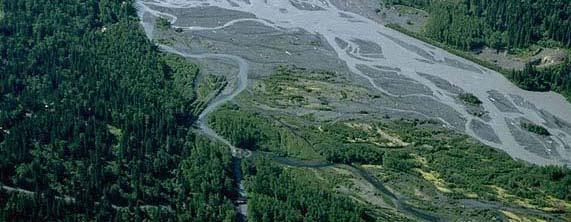
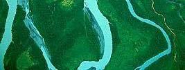
7 River corridor scale: features main channel width corridor width
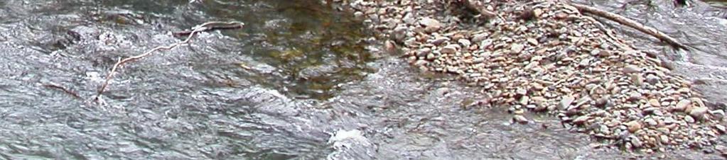
8 Cross sectional scale: point bars and alternate bars
9 Cross sectional scale: multiple bars corridor width main channel width
10 Aquatic Habitats River aquatic habitats include the floodplains. They depend on: Flow (discharge variations, velocities) Morphology (bed topography, spatial variability, cover) Sediment (transport and substrate) Water quality (pollutants, turbidity, temperature)
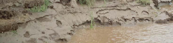
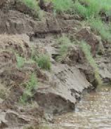
11 Morphology: spatial variability


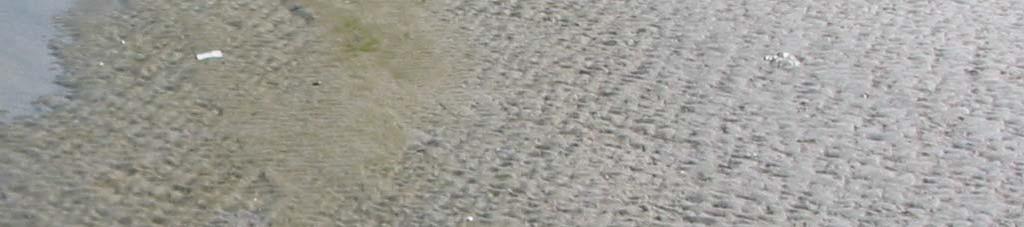
12 Substrate


13 Substrate t and morpholog gy: cover from predators dt and sheltering
14 IMPORTANCE OF BEN NTHOS: Benthos is the food resources for fish and other aquatic animals and live on the substrate IMPORTANCE OF SUBS STRATE: Substrate is of basic importance for benthos, for spawning grounds and fish larvae


15 Different species require different habitats depending on the stage of their life cycle: adult juvenile fry egg incubation reproduction

16 Due to the existence of specific biological calendars (species dependent) the requirements interms of substrate, flowvelocit ty, depth,cover vary with the season. Biological calendar of the Grayling (Thymallus thymallus) dult uvenile ry ncubation eproduction JAN FEB MAR APR MAY JUN JUL AUG SEP OCT NOV DEC
17 Morphodynamic phenomena Morphological phenomena: are the results of the processes at different spatial and temporal scales. Each has specific spatial scales basin scale (sediment yield, discharge generation) reach scale (riverbed aggradation and degradation, planform formation, river slope changes, avulsion) river corridor scale (floodplainrise rise, cut off forming, regular flooding, bend growth, channel migration) cross sectional scale (bar forming, pool forming, bank retreat, river widening or narrowing g) depth scale (bank erosion, scour forming, dune and antidune forming) process scale scale (ripple formin ng)
18 Morphodynamic phenomena Morphological phenomena: are the results of the processes at different spatial and temporal scales. Each has specific spatial scales basin scale (sediment yield, discharge generation) reach scale (riverbed aggradation and degradation, planform formation, river slope changes, avulsion) river corridor scale (floodplainrise rise, cut off forming, regular flooding, bend growth, channel migration) cross sectional scale (bar forming, pool forming, bank retreat, river widening or narrowing g) depth scale (bank erosion, scour forming, dune and antidune forming) process scale scale (ripple formin ng)


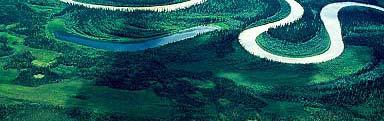
19 Morphological processes at the reach/corridor scale Sinuosity Bend growth Channel migration Planimetric changes Bend cut off/aggradation


20 Morphological phenomenon deposit formation at the cross sectional scale: large
21 orphological phenomenon at the depth scale: bank rosion
22 CHARACTERISTIC TEMPORAL SCALES MORPHOLOGICAL PHE ENOMENA Depend on the amounts of sediment to be moved to produce the changes and on the flow strength Example assuming the same discharge: Ripple forming: fast (minutes) Dune forming: rather fast (days) Pointbar forming: medium (mon nths to years) Pool forming: medium (months Planimetricchanges: i slow (tens to years) of years) Valley formation: very slow (hundred of years)
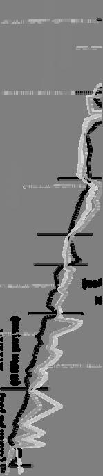
23 DISCHARGE CYCLE Most rivers display an annual discharge cycle, although there are large differences between years Fl low, m^3/s g y, Month Avg Stdev Congo River at Kinshasa Black curve shows average, red shows standard deviation for the years
24 Jamuna River (Bangladesh) 100, Discharge of the Jamuna River 80,000 Discharg ge (m³/s) 60,000 40,000 20, Year
25 IS THERE A FORMATIVE DISCHARGE? A single formative discharge does not exist: each type of geomorphological phenomenon has a different formative discharge For environmental lflows many values of the discharge should be considered: Low flows (sedimentation of fines) High flows (flushing) specifying AMOUNT, TIMING & DURATION


26 River Reach Classification Each reach type displays different features as a result of morphological processes SEA STEEP MOUNTAIN BRAIDED MEANDERING DELTA REACH REACH REACH


27 Factors governing the river planform formation Flow strength Sediment supply Sdi Sediment composition Bank erodibility Riparian vegetation Frequency of floods SEA TEEP OUNTAIN EACH BRAIDED MEANDERING DELT TA REACH REACH
28 MEANDERING vs BRAIDING Low flow strength Low sediment supply Fine sediment Low bank erodibility Dense riparian vegetation Low frequency of intense floods High flow strength Highsediment supply Coarse sediment Highbank erodibility Scarce riparian vegetation High frequency of intense floods
29 River Connectivity: 4 Dimensions Longitudinal Sediment movement Dams Lateral Connection to floodplain Flooding regime Vertical Interstatial spaces Temporal Connected in time, seasonal Dams
30 River Connectivity: 4 Dimensions Longitudinal onsider these in e-flow assessment Dams Sediment movement Dams Lateral Connection to floodplain Flooding regime Vertical Interstatial spaces Temporal Connected in time, seasonal


31 TYPE OF SEDIMENT: NON COHESIVE sand + gravel cobbles


32 TYPE OF SEDIMENT: COHESIVE silt and clay
33 Sediment classification based on grain size (A.G.U.) Clay: D < 4 μm Silt: 4 μm < D < 62 μm Fine sand: 62 μm < D < 250 μmμ Medium sand: 250 μm < D < 500 μm Coarse sand: 500 μm < D < 1000 μm Very coarse sand: 1000 μm < D < 2000 μm Gravel: 2 mm < D < 64 mm Cobbles: 64 mm < D < 256 mm Boulders: D > 256 mm FINES
34 GRANULOMETRIC CURVES
35 Sediment Transport CAPACITY LIMITED Classification based on origin bed-material load washload bedload suspended load Classification based on transport mechanism SUPPLY LIMITED Z related to flow strength th (flow velocity / stream power / shear stress / Shields parameter) SUSPENDED LOAD BED LOAD c
36 Transport Capacity Formulas Give the amount of sediment passing through a crossvelocity section as a function of flow Derived in the lab Capacity limited formulas: Engelund & Hansen, Meyer Peter & Müller, Van Rijn Power law: qs Not for wash load = b u mu Qw water Qs suspension load Qs bedload
37 Sediment and Morphological Modelling Couples sediment transport formulas to hydraulic engines Models cover allscales Basin reach cross section etc Nested modelling can offer strategic, basin wide, overview of morphological processes and response Catchment model for sediment yield 1D for sediment movement, channel migration (aggradation/deposition) 2D for detailled processes bank erosion, over bank processes 3D for detail e.g. reservoir sediments
 Further work: catchment")
38 Example: Mekong River, Reservoir Sedimentation Mekong River Commission Reservoir sedimentation Flushing options (Francis Fruchart CNR France) Further work: catchment connectivity


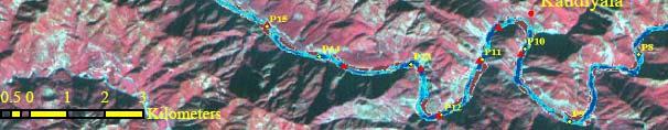


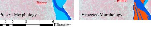
39 Example: Ganga River: Lateral Connectivity Present form GIS, Satellite, DEM analysis Future form Cross sections increase to Cross sections, increase to flow depth
40 Summary Important components for EFA: Habitats at various scales Processes at various scales Sediment types Prediction methods Case studies
41 Thanks for listening!

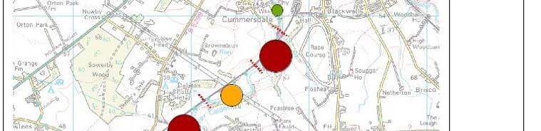
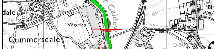
42 Case Study: Sediment increasing flood risk Approximately 3000properties across the city may be at risk of flooding Historic perception that the accumulation of sediment is a cause of flooding in central Carlisle. Past flood risk management along the lower Caldew involved repeated dredging Tributary of the River Eden Catchment area of 275 km 2 Rainfall 2800 mm/year Flashy flow regime
43 Methodology Nested spatial approach Geomorphological Assessment of 12km of river 1D Long term Sediment Modelling of 4km of River Geomorphological Assessme nt Field Study Sediment Budget Sediment and Hydraulic modelling (ISIS and ISIS Sediment) Long term hydrological hd linflow dt data for sediment model dl Modelling to ascertain trends in bed movement
44 Geomorphological Assessment Reviewofprevious studies Historical trend analysis Archive record search Environmental data sets Geomorphological mapping Sediment budget construction


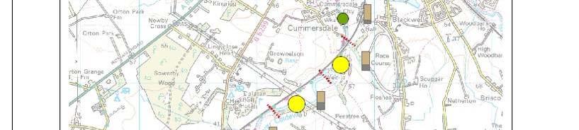


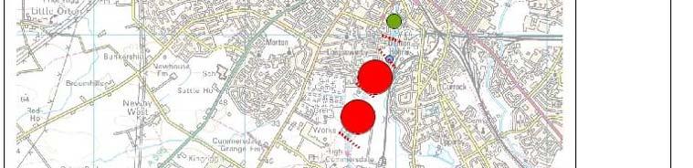


45 Sediment Budget 1 Erosion Deposition

 per Sediment 4 3 2 1 Buckabank")


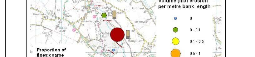
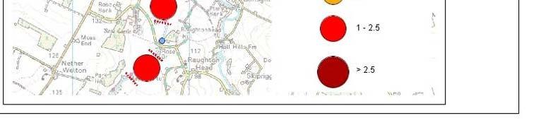
46 Sediment Budget 2 ~5 year budget Erosion and Deposition normalised by reach length (metres) 6 5 metre volume (m 3 ) per Sediment Buckabank weir Erosion per metre Reach number Erosion = 13,731 m 3 Deposition =14 4,842 m Deposition per metre Carlisle
 Model construction Existing")


 Areas of")


47 Modelling: Sediment & Hydraulics (Method) Model construction Existing ISIS model coupled to sediment module Bed samples collected from the river Validation and sensitivity assessment Long term hydrological inflow data Model simulations (Event based, 5 year and 12 year) Areas of erosion/deposition linked to geomorphological findings Identify accumulation sites for berm analysis Investigate impact to Standard of Protection through h Carlisle l


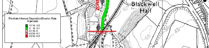
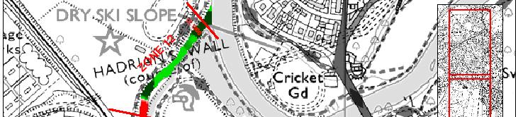


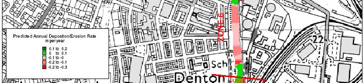
48 Modelling: Sediment & Hydraulics (Results)


49 Modelling: Sediment & Hydraulics (Results)
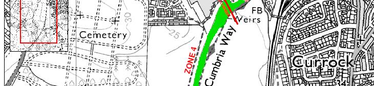
50 Conclusions Currently the River Caldew is in dynamic equilibrium Deposition upstream of Holdmhead Weir Erosion downstrem Sediment deposition solely does not exacerbate current flood risk through Carlisle Vegetation stabilises bars through the reach Vegetation does exacerbate flood risk Natural sediment exchange upstream of Carlisle should be allowed to continue
Strategies for managing sediment in dams. Iwona Conlan Consultant to IKMP, MRCS
 Strategies for managing sediment in dams Iwona Conlan Consultant to IKMP, MRCS 1 Sediment trapping by dams Active storage capacity Dead storage coarse material (bed load) Fine materials (suspension) Francis
SCOPE OF PRESENTATION STREAM DYNAMICS, CHANNEL RESTORATION PLANS, & SEDIMENT TRANSPORT ANALYSES IN RELATION TO RESTORATION PLANS
 DESIGN METHODS B: SEDIMENT TRANSPORT PROCESSES FOR STREAM RESTORATION DESIGN PETER KLINGEMAN OREGON STATE UNIVERSITY CIVIL ENGINEERING DEPT., CORVALLIS 2 ND ANNUAL NORTHWEST STREAM RESTORATION DESIGN SYMPOSIUM
Stream Geomorphology. Leslie A. Morrissey UVM July 25, 2012
 Stream Geomorphology Leslie A. Morrissey UVM July 25, 2012 What Functions do Healthy Streams Provide? Flood mitigation Water supply Water quality Sediment storage and transport Habitat Recreation Transportation
Do you think sediment transport is a concern?
 STREAM RESTORATION FRAMEWORK AND SEDIMENT TRANSPORT BASICS Pete Klingeman 1 What is Your Restoration Project Like? k? Do you think sediment transport is a concern? East Fork Lewis River, WA Tidal creek,
Step 5: Channel Bed and Planform Changes
 Step 5: Channel Bed and Planform Changes When disturbed, streams go through a series of adjustments to regain equilibrium with the flow and sediment supply of their watersheds. These adjustments often
(3) Sediment Movement Classes of sediment transported
 Sediment Movement Classes of sediment transported") 9/17/15 (3) Sediment Movement Classes of sediment transported Dissolved load Suspended load Important for scouring algae Bedload (5-10% total load) Moves along bed during floods Source of crushing for
9/17/15 (3) Sediment Movement Classes of sediment transported Dissolved load Suspended load Important for scouring algae Bedload (5-10% total load) Moves along bed during floods Source of crushing for
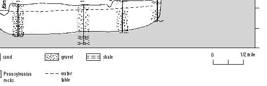
Aquifer an underground zone or layer of sand, gravel, or porous rock that is saturated with water.
 Aggradation raising of the streambed by deposition that occurs when the energy of the water flowing through a stream reach is insufficient to transport sediment conveyed from upstream. Alluvium a general
Development and application of demonstration MIKE 21C morphological model for a bend in Mekong River
 Development and application of demonstration MIKE 21C morphological model for a bend in Mekong River September 2015 0 Table of Contents 1. Introduction... 2 2. Data collection... 3 2.1 Additional data...
(3) Sediment Movement Classes of sediment transported
 Sediment Movement Classes of sediment transported") (3) Sediment Movement Classes of sediment transported Dissolved load Suspended (and wash load ) Important for scouring algae Bedload (5-10% total load Moves along bed during floods Source of crushing for
(3) Sediment Movement Classes of sediment transported Dissolved load Suspended (and wash load ) Important for scouring algae Bedload (5-10% total load Moves along bed during floods Source of crushing for
ADDRESSING GEOMORPHIC AND HYDRAULIC CONTROLS IN OFF-CHANNEL HABITAT DESIGN
 ADDRESSING GEOMORPHIC AND HYDRAULIC CONTROLS IN OFF-CHANNEL HABITAT DESIGN Conor Shea - Hydrologist U.S. Fish and Wildlife Service Conservation Partnerships Program Arcata, CA Learning Objectives Examine
Sedimentation in the Nile River
 Advanced Training Workshop on Reservoir Sedimentation Sedimentation in the Nile River Prof. Dr. Abdalla Abdelsalam Ahmed 10-16 Oct. 2007, IRTCES, Beijing, China CWR,Sudan 1 Water is essential for mankind
BZ471, Steam Biology & Ecology Exam 1
 BZ471, Exam1, p.1 BZ471, Steam Biology & Ecology Exam 1 Name Matching. Select the single best (most precise) answer for each of the following. Use each answer no more than once. No partial credit is given.
Dolores River Watershed Study
 CHAPTER 4: RIVER AND FLOODPLAIN ISSUES The Dolores River falls into a category of streams in Colorado that share some unique characteristics. Like some other mountain streams in the state, it has a steep
Riparian Assessment. Steps in the right direction... Drainage Basin/Watershed: Start by Thinking Big. Riparian Assessment vs.
 Riparian Assessment vs. Monitoring Riparian Assessment What is a healthy stream? Determine stream/riparian health Determine change or trend, especially in response to mgmt Classification = designation
How to predict the sedimentological impacts of reservoir operations?
 ICSE 212 How to predict the sedimentological impacts of reservoir operations? E. Valette EDF CIH eric.valette@edf.fr M. Jodeau EDF R&D LNHE magali.jodeau@edf.fr Presentation of the numerical code Courlis
Tom Ballestero University of New Hampshire. 1 May 2013
 Tom Ballestero University of New Hampshire 1 May 2013 1 Hydrology 2 Basic Hydrology Low flows most common Flows that fill the stream to the banks and higher are much less common Filling the stream to the
HYDRAULIC STRUCTURES, EQUIPMENT AND WATER DATA ACQUISITION SYSTEMS - Vol. I - Hydraulics of Two-Phase Flow: Water and Sediment - G R Basson
 HYDRAULICS OF TWO-PHASE FLOWS: WATER AND SEDIMENT G R Basson Dept. of Civil Engineering, University of Stellenbosch, South Africa. Keywords: sediment, sediment transport, turbulence, river regime, stream
River Response. Sediment Water Wood. Confinement. Bank material. Channel morphology. Valley slope. Riparian vegetation.
 River Response River Response Sediment Water Wood Confinement Valley slope Channel morphology Bank material Flow obstructions Riparian vegetation climate catchment vegetation hydrological regime channel
Wetland & Floodplain Functional Assessments and Mapping To Protect and Restore Riverine Systems in Vermont. Mike Kline and Laura Lapierre Vermont DEC
 Wetland & Floodplain Functional Assessments and Mapping To Protect and Restore Riverine Systems in Vermont Mike Kline and Laura Lapierre Vermont DEC NWI+ Hydro-Geomorphic Characterization of Wetlands and
MATHEMATICAL MODELING OF FLUVIAL SEDIMENT DELIVERY, NEKA RIVER, IRAN. S.E. Kermani H. Golmaee M.Z. Ahmadi
 JOURNAL OF ENVIRONMENTAL HYDROLOGY The Electronic Journal of the International Association for Environmental Hydrology On the World Wide Web at http://www.hydroweb.com VOLUME 16 2008 MATHEMATICAL MODELING
7.3 Sediment Delivery Analysis
 7.3 Sediment Delivery Analysis In order to evaluate potential changes in sedimentation patterns that could occur due to impacts from the FCP and LPP alignments, sediment assessment models were constructed
Technical Review of Pak Beng Hydropower Project (1) Hydrology & Hydraulics and (2) Sediment Transport & River Morphology
 Hydrology & Hydraulics and (2) Sediment Transport & River Morphology") Technical Review of Pak Beng Hydropower Project (1) Hydrology & Hydraulics and (2) Sediment Transport & River Morphology The 2 nd Regional Stakeholder Forum The Pak Beng Hydropower Project 5 th May 2017
Technical Review of Pak Beng Hydropower Project (1) Hydrology & Hydraulics and (2) Sediment Transport & River Morphology The 2 nd Regional Stakeholder Forum The Pak Beng Hydropower Project 5 th May 2017
Tarbela Dam in Pakistan. Case study of reservoir sedimentation
 Tarbela Dam in Pakistan. HR Wallingford, Wallingford, UK Published in the proceedings of River Flow 2012, 5-7 September 2012 Abstract Reservoir sedimentation is a main concern in the Tarbela reservoir
NATURAL RIVER. Karima Attia Nile Research Institute
 NATURAL RIVER CHARACTERISTICS Karima Attia Nile Research Institute NATURAL RIVER DEFINITION NATURAL RIVER DEFINITION Is natural stream of water that flows in channels with ih more or less defined banks.
Final Report. Prepared for. American Rivers, California Trout, Friends of the River and Trout Unlimited
 A of the Potential Downstream Sediment Deposition Following the Removal of Iron Gate, Copco, and J.C. Boyle Dams, Klamath River, CA Final Report Prepared for American Rivers, California Trout, Friends
PART 2:! FLUVIAL HYDRAULICS" HYDROEUROPE
 PART 2:! FLUVIAL HYDRAULICS" HYDROEUROPE 2009 1 HYDROEUROPE 2009 2 About shear stress!! Extremely complex concept, can not be measured directly!! Computation is based on very primitive hypotheses that
Upper Drac River restoration project
 Upper Drac River restoration project Restoration of a braided river bed incised in clay substratum through sediment reloading and bed widening SHF Conference, Nantes, 6 & 7 october 2014 Small scale morphological
Coarse Sediment Augmentation on Regulated Rivers. Scott McBain McBain & Trush, Inc.
 Coarse Sediment Augmentation on Regulated Rivers Scott McBain McBain & Trush, Inc. scott@mcbaintrush.com Components Some geomorphic and ecological considerations Conceptual approach at understanding augmentation
State of the River: Geomorphic Structure. Josh Wyrick, Ph.D. UC Davis
 State of the River: Geomorphic Structure Josh Wyrick, Ph.D. UC Davis 1 Geomorphic Structure Methodology Data Collection (topography, rating curve, hydraulics, substrate, vegetation & cover) GIS-Based Analyses
Why Geomorphology for Fish Passage
 Channel Morphology - Stream Crossing Interactions An Overview Michael Love Michael Love & Associates mlove@h2odesigns.com (707) 476-8938 Why Geomorphology for Fish Passage 1. Understand the Scale of the
Rivers T. Perron
 1 Rivers T. Perron 12.001 After our discussions of large-scale topography, how we represent topography in maps, and how topography interacts with geologic structures, you should be frothing at the mouth
The River Restoration Centre therrc.co.uk. Understanding Fluvial Processes: supporting River Restoration. Dr Jenny Mant
 The River Restoration Centre therrc.co.uk Understanding Fluvial Processes: supporting River Restoration Dr Jenny Mant Jenny@therrc.co.uk Understanding your catchment Hydrology Energy associated with the
Perspectives on river restoration science, geomorphic processes, and channel stability
 Perspectives on river restoration science, geomorphic processes, and channel stability Stream Restoration Forum: Science and Regulatory Connections Andrew C. Wilcox Department of Geosciences University
Sediment Transport, Numerical Modeling and Reservoir Management some Concepts and Applications
 Sediment Transport, Numerical Modeling and Reservoir Management some Concepts and Applications CEMRACS 2013 August 6 th Magali Jodeau EDF R&D LNHE magali.jodeau@edf.fr Overview of the presentation What
Water quality needs: Flow, velocity. Fish biologists need: Critical depth or velocity. Hydrology gives flows m 3 /s or day
 Environmental Water Allocation Hydraulics Dr L Beevers Heriot Watt University, it UK l.beevers@hw.ac.uk Overview Why hydraulics in EWA? Different types of flows Theory Case studies Review Why do we need
Overview of fluvial and geotechnical processes for TMDL assessment
 Overview of fluvial and geotechnical processes for TMDL assessment Christian F Lenhart, Assistant Prof, MSU Research Assoc., U of M Biosystems Engineering Fluvial processes in a glaciated landscape Martin
Erosion Surface Water. moving, transporting, and depositing sediment.
 + Erosion Surface Water moving, transporting, and depositing sediment. + Surface Water 2 Water from rainfall can hit Earth s surface and do a number of things: Slowly soak into the ground: Infiltration
NATURE OF RIVERS B-1. Channel Function... ALLUVIAL FEATURES. ... to successfully carry sediment and water from the watershed. ...dissipate energy.
 1 2 Function... Sevier River... to successfully carry sediment and water from the watershed....dissipate energy. 3 ALLUVIAL FEATURES 4 CHANNEL DIMENSION The purpose of a stream is to carry water and sediment
Restoration Goals TFG Meeting. Agenda
 San Joaquin River Restoration Program Restoration Goals TFG Meeting Reach 2B Update April 28, 2010 Agenda 1. Introductions 2. Program Restoration Goal Context 3. Program Update a) Interim Flows b) EIS/EIR
Diagnostic Geomorphic Methods for Understanding Future Behavior of Lake Superior Streams What Have We Learned in Two Decades?
 Diagnostic Geomorphic Methods for Understanding Future Behavior of Lake Superior Streams What Have We Learned in Two Decades? Faith Fitzpatrick USGS WI Water Science Center, Middleton, WI fafitzpa@usgs.gov
What? River response to base level rise. The morphodynamic system. Why? Channel-forming discharge. Flow. u = What s in a name. Flow Sediment transport
 River response to base level rise and other boundary conditions Dr. Maarten Kleinhans Summer course climate change and fluvial systems Course materials of Prof. Gary Parker Flow Sediment transport What?
LAB-SCALE INVESTIGATION ONBAR FORMATION COORDINATES IN RIVER BASED ON FLOW AND SEDIMENT
 LAB-SCALE INVESTIGATION ONBAR FORMATION COORDINATES IN RIVER BASED ON FLOW AND SEDIMENT Mat Salleh M. Z., Ariffin J., Mohd-Noor M. F. and Yusof N. A. U. Faculty of Civil Engineering, University Technology
ES 105 Surface Processes I. Hydrologic cycle A. Distribution % in oceans 2. >3% surface water a. +99% surface water in glaciers b.
 ES 105 Surface Processes I. Hydrologic cycle A. Distribution 1. +97% in oceans 2. >3% surface water a. +99% surface water in glaciers b. >1/3% liquid, fresh water in streams and lakes~1/10,000 of water
Influence of Morphological Changes on Ecology: A Cascade of Scales
 Influence of Morphological Changes on Ecology: A Cascade of Scales Prof. Dr.-Ing. Silke Wieprecht University Stuttgart Institute of Hydraulic Engineering Department of Hydraulic Engineering and Water Resources
Determining the Suitable Sediment extraction Locations of Existing Sand and Gravel Mines on Boshar River in Iran using HEC-RAS Modeling
 ICSE6-134 Determining the Suitable Sediment extraction Locations of Existing Sand and Gravel Mines on Boshar River in Iran using HEC-RAS Modeling Mohammad GHARESIFARD 1, Ali JAHEDAN 2, Bahar MOLAZEM 3
Unconventional Wisdom and the Effects of Dams on Downstream Coarse Sediment Supply. Byron Amerson, Jay Stallman, John Wooster, and Derek Booth
 Unconventional Wisdom and the Effects of Dams on Downstream Coarse Sediment Supply 3 February 2009 Byron Amerson, Jay Stallman, John Wooster, and Derek Booth Sultan River, WA OBJECTIVE Consider the landscape
Watershed concepts for community environmental planning
 Purpose and Objectives Watershed concepts for community environmental planning Dale Bruns, Wilkes University USDA Rural GIS Consortium May 2007 Provide background on basic concepts in watershed, stream,
Earth Science Chapter 6 Section 2 Review
 Name: Class: Date: Earth Science Chapter 6 Section Review Multiple Choice Identify the choice that best completes the statement or answers the question. 1. Most streams carry the largest part of their
River floodplain regime and stratigraphy. Drs. Nanette C. Kingma.
 River floodplain regime and stratigraphy. Drs. Nanette C. Kingma. Formation of floodplain. Formation of floodplains: lateral channel migration in channel deposition suspended-load fall out during higher
Sediment management plans in French mountainous catchments with illustrations from emblematic projects Dr. Benoit Terrier
 Sediment management plans in French mountainous catchments with illustrations from emblematic projects Dr. Benoit Terrier Agence de l Eau Rhône Méditerranée et Corse, FRANCE Presentation layout 1. The
60 PERCENT DESIGN REPORT HABITAT RESTORATION OF THE CHELAN RIVER REACH 4 AND TAILRACE
 60 PERCENT DESIGN REPORT HABITAT RESTORATION OF THE CHELAN RIVER REACH 4 AND TAILRACE Prepared for Public Utility District Number 1 of Chelan County 327 North Wenatchee Avenue Wenatchee, Washington 98801
Analysis of Sedimentation in Wonogiri Reservoir
 Journal of the Civil Engineering Forum Vol. 2 No. 1 (January 2016) Analysis of Sedimentation in Wonogiri Reservoir Tri Joko Inti Budi Santosa Large River Basin Organization of Bengawan Solo, Surakarta,
Surface Water and Stream Development
 Surface Water and Stream Development Surface Water The moment a raindrop falls to earth it begins its return to the sea. Once water reaches Earth s surface it may evaporate back into the atmosphere, soak
Subcommittee on Sedimentation Draft Sediment Analysis Guidelines for Dam Removal
 Subcommittee on Sedimentation Draft Sediment Analysis Guidelines for Dam Removal August 4, 2011 Jennifer Bountry, M.S., P.E. Tim Randle, M.S., P.E., D.WRE. Blair Greimann, Ph.D., P.E. Sedimentation and
RESTORATION DESIGN FOR REROUTED WATERCOURSES
 With thanks to: Thames Water Utilities Limited RESTORATION DESIGN FOR REROUTED WATERCOURSES Project Design Team Colin Thorne, Nick Clifford Gary Priestnall Philip Soar Kieran Conlan, Steve Dangerfield
STUDY GUIDE FOR CONTENT MASTERY. Surface Water Movement
 Surface Water SECTION 9.1 Surface Water Movement In your textbook, read about surface water and the way in which it moves sediment. Complete each statement. 1. An excessive amount of water flowing downslope
BZ471, Steam Biology & Ecology Exam
 BZ471, Eam1, p.1 BZ471, Steam Biology & Ecology Eam Name Multiple choice When benthic organisms enter the water column with a regular diel periodicity: a) catastrophic drift b) behavioral drift c) constant
How Do Human Impacts and Geomorphological Responses Vary with Spatial Scale in the Streams and Rivers of the Illinois Basin?
 How Do Human Impacts and Geomorphological Responses Vary with Spatial Scale in the Streams and Rivers of the Illinois Basin? Bruce Rhoads Department of Geography University of Illinois at Urbana-Champaign
 1.3.1.1 Incipient Motion Particle movement will occur when the instantaneous fluid force on a particle is just larger than the instantaneous resisting force related to the submerged particle weight and
Fact sheet: Glacial rivers (all Europe)
") Fact sheet: Glacial rivers (all Europe) General description Valleyplanform Hydrology and The valley form varies from a gorge to a V-shaped valley and the single-thread channel is mainly characterized by
Fact sheet: Glacial rivers (all Europe) General description Valleyplanform Hydrology and The valley form varies from a gorge to a V-shaped valley and the single-thread channel is mainly characterized by
Limitation to qualitative stability indicators. the real world is a continuum, not a dichotomy ~ 100 % 30 % ~ 100 % ~ 40 %
 Stream Stability Assessment & BEHI Surveys Joe Rathbun MDEQ Water Resources Division rathbunj@michigan.gov 517--373 517 373--8868 Stability Stream can transport its water and sediment inputs without changing
Landscape Development
 Landscape Development Slopes Dominate Natural Landscapes Created by the interplay of tectonic and igneous activity and gradation Deformation and uplift Volcanic activity Agents of gradation Mass wasting
Upper Truckee River Restoration Lake Tahoe, California Presented by Brendan Belby Sacramento, California
 Upper Truckee River Restoration Lake Tahoe, California Presented by Brendan Belby Sacramento, California Mike Rudd (Project Manager), Charley Miller & Chad Krofta Declines in Tahoe s Water Clarity The
Geomorphology Geology 450/750 Spring Fluvial Processes Project Analysis of Redwood Creek Field Data Due Wednesday, May 26
 Geomorphology Geology 450/750 Spring 2004 Fluvial Processes Project Analysis of Redwood Creek Field Data Due Wednesday, May 26 This exercise is intended to give you experience using field data you collected
The SedAlp Project: WP6: INTERACTION WITH STRUCTURES
 The SedAlp Project: WP6: INTERACTION WITH STRUCTURES 6 th International conference Water in the Alps Herrenchiemsee, 12 th of October, 2016 Jošt Sodnik Contents Structure of SedAlp project (www.sedalp.eu)
HEC-RAS Reservoir Transport Simulation of Three Reservoirs in the Lower Susquehanna River Basin. Mike Langland and Ed Koerkle
 HEC-RAS Reservoir Transport Simulation of Three Reservoirs in the Lower Susquehanna River Basin Mike Langland and Ed Koerkle Topics Background / Project Objectives Data Selection - Sediment and Geometric
Dam Removal Analysis Guidelines for Sediment
 A review of: Dam Removal Analysis Guidelines for Sediment Joe Rathbun (Retired) rathbunj@sbcglobal.net Some Potential Sediment Issues Reservoir restoration Downstream water quality Downstream deposition
!"#$%&&'()*+#$%(,-./0*)%(!
*+#$%(,-./0*)%(!") 8:30 Sign in Hoosic River Revival Coalition!"#$%&&'()*+#$%(,-./0*)%(! 12-#30+4/#"5-(60 9:00 Welcome and Introductions 9:15 Goals for Today s Program: A Description of the Planning Process 9:30 First Session:
8:30 Sign in Hoosic River Revival Coalition!"#$%&&'()*+#$%(,-./0*)%(! 12-#30+4/#"5-(60 9:00 Welcome and Introductions 9:15 Goals for Today s Program: A Description of the Planning Process 9:30 First Session:
BED LOAD SEDIMENT TRANSPORT
 BED LOAD SEDIMENT TRANSPORT Kamal EL KADI ABDERREZZAK EDF-R&D, Laboratoire National d Hydraulique et Environnement (LNHE) 1 17-19 September 2009 UNL, Santa Fe, Argentina OUTLINE I. Bed load II. Settling
Dams, sediment, and channel changes and why you should care
 Dams, sediment, and channel changes and why you should care Gordon E. Grant USDA Forest Service PNW Research Station Corvallis, Oregon Dam effects on river regimes FLOW (Q) SEDIMENT (Qs) TEMP CHEMISTRY
Final Report for TWDB Contract No
 Final Report for TWDB Contract No. 1004831127 Sediment Transport Modeling of Channel Scale Geomorphic Processes J.K. Haschenburger University of Texas at San Antonio July 31, 2012 1 Introduction This study
Stream Restoration and Environmental River Mechanics. Objectives. Pierre Y. Julien. 1. Peligre Dam in Haiti (deforestation)
") Stream Restoration and Environmental River Mechanics Pierre Y. Julien Malaysia 2004 Objectives Brief overview of environmental river mechanics and stream restoration: 1. Typical problems in environmental
Stream Restoration and Environmental River Mechanics Pierre Y. Julien Malaysia 2004 Objectives Brief overview of environmental river mechanics and stream restoration: 1. Typical problems in environmental
Technical Memorandum. To: From: Copies: Date: 10/19/2017. Subject: Project No.: Greg Laird, Courtney Moore. Kevin Pilgrim and Travis Stroth
 Technical Memorandum To: From: Greg Laird, Courtney Moore Kevin Pilgrim and Travis Stroth 5777 Central Avenue Suite 228 Boulder, CO 80301 www.otak.com Copies: [Electronic submittal] Date: 10/19/2017 Subject:
Rapid Geomorphic Assessments: RGA s
 Establishing Current Reference Conditions Rates and concentrations of suspended-sediment transport vary over time and space due to factors such as precipitation characteristics and discharge, geology,
Lectures Hydrology & Fluvial Geomorphology. Gauley River Images. Ancients' (= Biblical) Model of Water (Hydrologic) Cycle
 Model of Water (Hydrologic) Cycle") Lectures 11-13 13 Hydrology & Fluvial Geomorphology Gauley River Images http://www.youtube.com/watch?v=eulmuyegtz4&feature=related Ancients' (= Biblical) Model of Water (Hydrologic) Cycle Stream Water
Lectures 11-13 13 Hydrology & Fluvial Geomorphology Gauley River Images http://www.youtube.com/watch?v=eulmuyegtz4&feature=related Ancients' (= Biblical) Model of Water (Hydrologic) Cycle Stream Water
Project Proposal. Lyme Brook. Newcastle-under-Lyme. 3 rd July 2015
 Project Proposal Lyme Brook Newcastle-under-Lyme 3 rd July 2015 Contents Page 1.0 Introduction... 1.0 2.0 Background and rationale... 2.0 3.0 Proposed measures... 5 4.0 Summary of Recommendations... 10
Summary. Streams and Drainage Systems
 Streams and Drainage Systems Summary Streams are part of the hydrologic cycle and the chief means by which water returns from the land to the sea. They help shape the Earth s surface and transport sediment
6.11 Naas River Management Unit
 6.11 Naas River Management Unit 6.11.1 Site 41 Issue: Bed and bank erosion Location: E 0685848 N 6058358 Waterway: Naas River Management Unit: Naas River Facing downstream from Bobeyan Rd bridge Facing
Texas A & M University and U.S. Bureau of Reclamation Hydrologic Modeling Inventory Model Description Form
 Texas A & M University and U.S. Bureau of Reclamation Hydrologic Modeling Inventory Model Description Form JUNE, 1999 Name of Model: Two-Dimensional Alluvial River and Floodplain Model (MIKE21 CHD & CST)
Fluvial Processes in River Engineering
 Fluvial Processes in River Engineering Howard H. Chang San Diego State University... A WILEY-INTERSCIENCE PUBLTCATION John Wiley & Sons New York Chicbester Brisbane Toronto Singapore CONTENTS PARTI FLUVIAL
Why Stabilizing the Stream As-Is is Not Enough
 Why Stabilizing the Stream As-Is is Not Enough Several examples of alternatives to the County s design approach have been suggested. A common theme of these proposals is a less comprehensive effort focusing
Avoiding Geohazards in the Mid-Atlantic Highlands by Using Natural Stream Principles
 Avoiding Geohazards in the Mid-Atlantic Highlands by Using Natural Stream Principles J. Steven Kite, WVU Neal Carte, WVDOT Will Harman, Michael Baker Corp. Donald D. Gray, WVU Photo: W. Gillespie North
B-1. Attachment B-1. Evaluation of AdH Model Simplifications in Conowingo Reservoir Sediment Transport Modeling
 Attachment B-1 Evaluation of AdH Model Simplifications in Conowingo Reservoir Sediment Transport Modeling 1 October 2012 Lower Susquehanna River Watershed Assessment Evaluation of AdH Model Simplifications
ON SOME MOUNTAIN STREAMS AND RIVERS MORPHODYNAMICAL PARAMETER CHARACTERISTICS USING FIELD AND NUMERICAL MODELING
 Agricultural University of Krakow, Department of Water Engineering Wojciech Bartnik, Leszek Książek, Artur Radecki-Pawlik, Andrzej Strużyński ON SOME MOUNTAIN STREAMS AND RIVERS MORPHODYNAMICAL PARAMETER
3/3/2013. The hydro cycle water returns from the sea. All "toilet to tap." Introduction to Environmental Geology, 5e
 Introduction to Environmental Geology, 5e Running Water: summary in haiku form Edward A. Keller Chapter 9 Rivers and Flooding Lecture Presentation prepared by X. Mara Chen, Salisbury University The hydro
APPLICATION OF HEC-RAS MODEL FOR ESTIMATING CHANGES IN WATERCOURSE GEOMETRY DURING FLOODS
 Studia Geotechnica et Mechanica, Vol. XXXIV, No. 2, 2012 DOI: 105277/sgm021206 APPLICATION OF HEC-RAS MODEL FOR ESTIMATING CHANGES IN WATERCOURSE GEOMETRY DURING FLOODS JOANNA MARKOWSKA Department of Environmental
Stream Classification
 Stream Classification Why Classify Streams? Communication Tool Describe Existing Conditions & Trends Describe Restoration Goals Research Tool Morphologic Stream Classification Systems Schumm (1977) Alluvial
Technical note about the monitoring of hydromorphological restoration/management of the Drava River in Slovenia
 Technical note about the monitoring of hydromorphological restoration/management of the Drava River in Slovenia 1 Project: HyMoCARES Work package: WPC. Communication Activity: Web Site Deliverable: Case
Mangyeong River Hydraulic Modeling Analysis
 Mangyeong River Hydraulic Modeling Analysis Draft Prepared For: Korea Institute of Construction Technology, Republic of Korea by: Dr. Pierre Y. Julien Jaehoon Kim Colorado State University Engineering
mountain rivers fixed channel boundaries (bedrock banks and bed) high transport capacity low storage input output
 high transport capacity low storage input output") mountain rivers fixed channel boundaries (bedrock banks and bed) high transport capacity low storage input output strong interaction between streams & hillslopes Sediment Budgets for Mountain Rivers Little
mountain rivers fixed channel boundaries (bedrock banks and bed) high transport capacity low storage input output strong interaction between streams & hillslopes Sediment Budgets for Mountain Rivers Little
GLG362/GLG598 Geomorphology K. Whipple October, 2009 I. Characteristics of Alluvial Channels
 I. Characteristics of Alluvial Channels Self-formed morphology set by entrainment, transport, and deposition They move unconsolidated sedimentary materials present in the valley fill flood plain/bank flow
Fresh Water: Streams, Lakes Groundwater & Wetlands
 Fresh Water:, Lakes Groundwater & Wetlands Oct 27 Glaciers and Ice Ages Chp 13 Nov 3 Deserts and Wind and EXAM #3 Slope hydrologic cycle P = precip I = precip intercepted by veg ET = evapotranspiration
Rivers and Streams. Streams. Hydrologic Cycle. Drainage Basins and Divides. Colorado River Drainage Basin. Colorado Drainage Basins.
 Chapter 14 Hydrologic Cycle Rivers and Streams Streams A stream is a body of water that is confined in a channel and moves downhill under the influence of gravity. This definition includes all sizes of
GEOL 1121 Earth Processes and Environments
 GEOL 1121 Earth Processes and Environments Wondwosen Seyoum Department of Geology University of Georgia e-mail: seyoum@uga.edu G/G Bldg., Rm. No. 122 Seyoum, 2015 Chapter 6 Streams and Flooding Seyoum,
Licca Liber - the free Lech
 Licca Liber - the free Lech Source: W. Schilling WWA Donauwörth The river Lech an overview Hydrography / Hydrology catchment area 4000 km² Length 256 km Delta H 1100 m Slope Ø 0,4 % discharge in Augsburg
What do you need for a Marathon?
 What do you need for a Marathon? Water and a snack? What about just a normal day? 1 flush = 3.5 gallons 1 flush = 3.5 gallons 10 minute shower = 20 gal 1 flush = 3.5 gallons 10 minute shower = 20 gal Jeans
Illinois State Water Survey Division
 Illinois State Water Survey Division SURFACE WATER SECTION SWS Miscellaneous Publication 108 SEDIMENT YIELD AND ACCUMULATION IN THE LOWER CACHE RIVER by Misganaw Demissie Champaign, Illinois June 1989
Annual transport rates at two locations on the fore-slope.
 Sediment Transport by Currents Fore-slope Sediment transport rates and sediment concentrations were computed from the hydrodynamic model runs as well as from direct measurements of current velocities at
Running Water Earth - Chapter 16 Stan Hatfield Southwestern Illinois College
 Running Water Earth - Chapter 16 Stan Hatfield Southwestern Illinois College Hydrologic Cycle The hydrologic cycle is a summary of the circulation of Earth s water supply. Processes involved in the hydrologic
DAM REMOVAL ENGINEERING ISSUES & OPTIONS
 DAM REMOVAL ENGINEERING ISSUES & OPTIONS Presented by: James G. Mac Broom, P.E. Milone & Mac Broom, Inc. October 2011 CLEAR GOALS and OBJECTIVES Fish Passage Habitat Defragmentation Water Quality Dam Failure