Licca Liber - the free Lech
|
|
|
- Edward Lambert
- 6 years ago
- Views:
Transcription
1 Licca Liber - the free Lech

2 Source: W. Schilling WWA Donauwörth

3 The river Lech an overview Hydrography / Hydrology catchment area 4000 km² Length 256 km Delta H 1100 m Slope Ø 0,4 % discharge in Augsburg with Wertach MQ 114 m³/s HQ m³/s Source: wikipedia.org
4 Cross sections and lateral view

 Sector")
5 Area of interest Augsburg Gersthofen Lechkanal Staustufe Ellgau Staustufe 23 Gersthofener Wehr Hochablass Thierhaupten Sector 2 (south) Sector 1 (north)

6 Historical situation and after the correction Lech, heute Lech, 1924
 Problem increased: downstream erosions no sediment continuity reduction in ecological variety barriers for the")
7 Correction: length reduction Aims of the correction: Improved flood protection Land gain Reduction of groundwater level Patches against the progressive erosion (Canyon creation): hydraulic structures weirs, ground sill hydro power plants (diversion in Lechkanal north Augsburg) Problem increased: downstream erosions no sediment continuity reduction in ecological variety barriers for the aquatic fauna Source: W. Schilling WWA Donauwörth

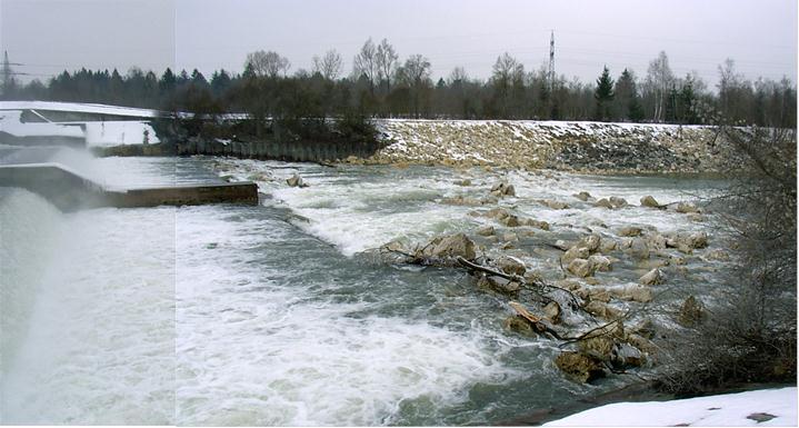
8 Hydro power plant chain from the Forgensee to Augsburg Source: W. Schilling WWA Donauwörth

9 HPP 23 total sediment trap Source: W. Schilling WWA Donauwörth

10 Consequences of the Sediment deficit (Wertach) Collapse of the Bobinger bridge Endangering of the Inningen barrage Source: W. Schilling WWA Donauwörth

11 Sister river: Wertach Erosion to a canyon river Sinking ground water level Source: W. Schilling WWA Donauwörth


12 Actual situation at the Lech

13 Visualization of erosion from 1993 to 2010 (south sector)
14 Volume balance Sector 2
15 Hydraulic problem at the old hydraulic structures HW99 structure Rip rap Gravel / river bed

16 And other design problems Source: W. Schilling WWA Donauwörth


17 Visualization of erosion from 1986 to 2010 (north sector)
18 Volume balance Sector 1


19 Bank erosions in the north sector
20 Different studies from water management office Donauwörth came to same results Lech is a morphological intensive active river (Station 56.7 to Danube) Sediment transport (eroded) m³/a Transport capacity from around m³ /a Average erosion between 1cm and 3.5 cm per year Local erosions between 1m and 3m in 3 decades Source: W. Schilling WWA Donauwörth

21 Photos from the Lech south Augsburg At 1908 and today Possible width for restoration and stabilization Source: W. Schilling WWA Donauwörth

22 Look around for an successful restoration Source: W. Schilling WWA Donauwörth

23 Widening combined with open armored layer Source: W. Schilling WWA Donauwörth

24 Source: W. Schilling WWA Donauwörth


25 Regime - Lech original actual continuative branched No manipulated discharge Natural sediment flux Separated /interrupted habitats restricted Controlled discharge No sediment inflow from upstream future?


26 Cover layer - armoring?
27 Grain size distribution (south sector) River bed material Bank material Natural armoring layer

28 Regime Classification (Zarn) Grain diameter: d m ~ 0,02 m verzweigt slope: 1,0 < I < 2,0 width: 80 m < B < 180 m alternierende Bänke Alternierende Bänke / Mäander Mäander

29 Can we go back to this regime?
30 Cross section (regime sustainability?) Formed by flood Natural bank fixation (manipulated hydrograph) -> forced erosion in main channel -> concentrated discharge -> no new sediment from upstream -> cut branches off over widening is no solution
31 Find a solution Flora - Fauna Protection Morphological Stabilisation Human Morphodynamic sustainability Solution Actual situation
32 Variation parameter for morphological stabilization Slope Cross section design Roughness Iterative process manipulated hydrograph Flood protection, ground water level

33 Stabilization concepts slope Cross sectional design Roughness (bed and bank)
34 Possible stabilization concepts Slope of the river bed I Topography Technical construction I Stability I Stability < I Topography Morphological stability level Technical construction. Weirs, ramps and so on
35 Possible stabilization concepts Widening Alternierende Bänke Verzweigtes Gewässer
36 Possible stabilization concepts Open armored rip rap layer I topogr. = I Stability_New I stability, existing Increase erosion defense Existing situation: I stability < I Topography new concept: I stability. = I Topography Width [m] Stone diameter [cm] Number of stones per m² , , ,5


37 Stabilization Sector 2 south Augsburg scope Flood area between dikes: m width Connect existing lakes to Lech Recreate 1999 bed level (before flood event)
38 Stabilization Sector 2 south Augsburg Lateral view existing design - 1,1 1,8 Downstream protection of Lechstaustufe 23 2,1 1,6 1,7 1,5 2,264 missing stabilization 2,2
39 Stabilization Sector 2 south Augsburg Lateral view H L = 3450 m 50% - 75 % of H must be stabilizated
40 Stabilization Sector 2 south Augsburg H (OK HX ) I (Hochablass Schwelle 6) H Soll 488, ,25 3,0 3,5 2,24-2,13 H ,76 5,5 1,52 Original design H ,19 6,1 1,35 H ,40 6,9 1,13 Av. level 1999 Talweg

41 Sinking groundwater level? development Sinking rate: ~. 0,65 cm/a Sinking rate: ca. 0,36 cm/a Weir structure 6
42 Connection of existing lakes to the Lech Ecological connection Improvement of water quality Initialization of a flushing No over-widening Diverted discharge? How much should be diverted from the Lech? How to connect? Technical construction Nature like connection (maybe not perfect controllable)


43 Weidmannsee level: 501,2 m asl Change in levee positions


44 Auensee level 493,10 m asl


45 Kuhsee level: 484,30 m asl

46 Sediment management Area for sediment compensation Directly downstream Storage reservoir 23

47 Thank you for your attention
Stream Restoration and Environmental River Mechanics. Objectives. Pierre Y. Julien. 1. Peligre Dam in Haiti (deforestation)
") Stream Restoration and Environmental River Mechanics Pierre Y. Julien Malaysia 2004 Objectives Brief overview of environmental river mechanics and stream restoration: 1. Typical problems in environmental
Stream Restoration and Environmental River Mechanics Pierre Y. Julien Malaysia 2004 Objectives Brief overview of environmental river mechanics and stream restoration: 1. Typical problems in environmental
The River Restoration Centre therrc.co.uk. Understanding Fluvial Processes: supporting River Restoration. Dr Jenny Mant
 The River Restoration Centre therrc.co.uk Understanding Fluvial Processes: supporting River Restoration Dr Jenny Mant Jenny@therrc.co.uk Understanding your catchment Hydrology Energy associated with the
The SedAlp Project: WP6: INTERACTION WITH STRUCTURES
 The SedAlp Project: WP6: INTERACTION WITH STRUCTURES 6 th International conference Water in the Alps Herrenchiemsee, 12 th of October, 2016 Jošt Sodnik Contents Structure of SedAlp project (www.sedalp.eu)
kein Wässerchen trüben
 Bundesamt für Wasserwirtschaft Institut für Wasserbau und hydrometrische Prüfung Federal Agency for Watermanagement Institute for Hydraulic Engineering and Calibration of Hydrometrical Current-Meters kein
Upper Drac River restoration project
 Upper Drac River restoration project Restoration of a braided river bed incised in clay substratum through sediment reloading and bed widening SHF Conference, Nantes, 6 & 7 october 2014 Small scale morphological
SCOPE OF PRESENTATION STREAM DYNAMICS, CHANNEL RESTORATION PLANS, & SEDIMENT TRANSPORT ANALYSES IN RELATION TO RESTORATION PLANS
 DESIGN METHODS B: SEDIMENT TRANSPORT PROCESSES FOR STREAM RESTORATION DESIGN PETER KLINGEMAN OREGON STATE UNIVERSITY CIVIL ENGINEERING DEPT., CORVALLIS 2 ND ANNUAL NORTHWEST STREAM RESTORATION DESIGN SYMPOSIUM
Field Observations and One-Dimensional Flow Modeling of Summit Creek in Mack Park, Smithfield, Utah
 Intermountain Center for River Rehabilitation and Restoration, Utah State University 31 July 2018 Field Observations and One-Dimensional Flow Modeling of Summit Creek in Mack Park, Smithfield, Utah I.
Fact sheet: Glacial rivers (all Europe)
") Fact sheet: Glacial rivers (all Europe) General description Valleyplanform Hydrology and The valley form varies from a gorge to a V-shaped valley and the single-thread channel is mainly characterized by
Fact sheet: Glacial rivers (all Europe) General description Valleyplanform Hydrology and The valley form varies from a gorge to a V-shaped valley and the single-thread channel is mainly characterized by
KEY CONTROLS ON SEDIMENT BUDGETING IN THE MISSISSIPPI RIVER FROM SOURCE TO SINK
 KEY CONTROLS ON SEDIMENT BUDGETING IN THE MISSISSIPPI RIVER FROM SOURCE TO SINK Mead Allison The Water Institute of the Gulf & Tulane University What Controls the Availability of Sediment in the Restoration
Restoring river-floodplain interconnection and riparian habitats along the embanked Danube between Neuburg and Ingolstadt (Germany)
") Restoring river-floodplain interconnection and riparian habitats along the embanked Danube between Neuburg and Ingolstadt (Germany) Dipl.-Geogr. Gerald Blasch Department of Physical Geography, Cath. University
Restoring river-floodplain interconnection and riparian habitats along the embanked Danube between Neuburg and Ingolstadt (Germany) Dipl.-Geogr. Gerald Blasch Department of Physical Geography, Cath. University
Technical Review of Pak Beng Hydropower Project (1) Hydrology & Hydraulics and (2) Sediment Transport & River Morphology
 Hydrology & Hydraulics and (2) Sediment Transport & River Morphology") Technical Review of Pak Beng Hydropower Project (1) Hydrology & Hydraulics and (2) Sediment Transport & River Morphology The 2 nd Regional Stakeholder Forum The Pak Beng Hydropower Project 5 th May 2017
Technical Review of Pak Beng Hydropower Project (1) Hydrology & Hydraulics and (2) Sediment Transport & River Morphology The 2 nd Regional Stakeholder Forum The Pak Beng Hydropower Project 5 th May 2017
RAILWAYS AND FISH: HOW TO PROTECT AND ENHANCE FISH HABITAT VALUES AT STREAM CROSSINGS THROUGH PROJECT DESIGN AND CONSTRUCTION
 RAILWAYS AND FISH: HOW TO PROTECT AND ENHANCE FISH HABITAT VALUES AT STREAM CROSSINGS THROUGH PROJECT DESIGN AND CONSTRUCTION Rail Environment Conference November 2016 AGENDA Objective Background Benefits
MATHEMATICAL MODELING OF FLUVIAL SEDIMENT DELIVERY, NEKA RIVER, IRAN. S.E. Kermani H. Golmaee M.Z. Ahmadi
 JOURNAL OF ENVIRONMENTAL HYDROLOGY The Electronic Journal of the International Association for Environmental Hydrology On the World Wide Web at http://www.hydroweb.com VOLUME 16 2008 MATHEMATICAL MODELING
Four Mile Run Levee Corridor Stream Restoration
 Four Mile Run Levee Corridor Stream Restoration 30% Design Summary U.S. Army Corps of Engineers, Baltimore District Presentation Outline Four Mile Run 1.) Historic Perspective 2.) Existing Conditions 3.)
Stream Geomorphology. Leslie A. Morrissey UVM July 25, 2012
 Stream Geomorphology Leslie A. Morrissey UVM July 25, 2012 What Functions do Healthy Streams Provide? Flood mitigation Water supply Water quality Sediment storage and transport Habitat Recreation Transportation
Sediment monitoring, long-term loads, balances and management strategies in southern Bavaria
 Erosion and Sediment Yield: Global and Regional Perspectives (Proceedings of the Exeter Symposium July 1996). IAHS Publ. no. 236, 1996. 575 Sediment monitoring, long-term loads, balances and management
Summary of Hydraulic and Sediment-transport. Analysis of Residual Sediment: Alternatives for the San Clemente Dam Removal/Retrofit Project,
 Appendix N SUMMARY OF HYDRAULIC AND SEDIMENT-TRANSPORT ANALYSIS OF RESIDUAL SEDIMENT: ALTERNATIVES FOR THE SAN CLEMENTE DAM REMOVAL/RETROFIT PROJECT, CALIFORNIA the San Clemente Dam Removal/Retrofit Project,
Improvement of navigation conditions on the Danube (Calarasi-Braila and Lower Danube) - Ecological concerns?
 - Ecological concerns?") Improvement of navigation conditions on the Danube (Calarasi-Braila and Lower Danube) - Ecological concerns? Georg Rast, Christine Bratrich, Orieta Hulea WWF Germany/DCPO Topics of the presentation Major
Improvement of navigation conditions on the Danube (Calarasi-Braila and Lower Danube) - Ecological concerns? Georg Rast, Christine Bratrich, Orieta Hulea WWF Germany/DCPO Topics of the presentation Major
RESTORATION DESIGN FOR REROUTED WATERCOURSES
 With thanks to: Thames Water Utilities Limited RESTORATION DESIGN FOR REROUTED WATERCOURSES Project Design Team Colin Thorne, Nick Clifford Gary Priestnall Philip Soar Kieran Conlan, Steve Dangerfield
DAM REMOVAL ENGINEERING ISSUES & OPTIONS
 DAM REMOVAL ENGINEERING ISSUES & OPTIONS Presented by: James G. Mac Broom, P.E. Milone & Mac Broom, Inc. October 2011 CLEAR GOALS and OBJECTIVES Fish Passage Habitat Defragmentation Water Quality Dam Failure
Technical note about the monitoring of hydromorphological restoration/management of the Drava River in Slovenia
 Technical note about the monitoring of hydromorphological restoration/management of the Drava River in Slovenia 1 Project: HyMoCARES Work package: WPC. Communication Activity: Web Site Deliverable: Case
River Restoration and Rehabilitation. Pierre Y. Julien
 River Restoration and Rehabilitation Pierre Y. Julien Department of Civil and Environmental Engineering Colorado State University Fort Collins, Colorado River Mechanics and Sediment Transport Lima Peru
CASE STUDY NATHPA JHAKRI, INDIA
 SEDIMENT MANAGEMENT CASE STUDY NATHPA JHAKRI, INDIA Key project features Name: Nathpa Jhakri Country: India Category: reduce sediment production (watershed management); upstream sediment trapping; bypass
Wetland & Floodplain Functional Assessments and Mapping To Protect and Restore Riverine Systems in Vermont. Mike Kline and Laura Lapierre Vermont DEC
 Wetland & Floodplain Functional Assessments and Mapping To Protect and Restore Riverine Systems in Vermont Mike Kline and Laura Lapierre Vermont DEC NWI+ Hydro-Geomorphic Characterization of Wetlands and
Technical Memorandum No
 Pajaro River Watershed Study in association with Technical Memorandum No. 1.2.10 Task: Evaluation of Four Watershed Conditions - Sediment To: PRWFPA Staff Working Group Prepared by: Gregory Morris and
NUMERICAL MODELLING IN ENVIRONMENTAL IMPACT ASSESSMENT OF CONSTRUCTION WORKS WITHIN RIVER BAYS - A CASE STUDY
 NUMERICAL MODELLING IN ENVIRONMENTAL IMPACT ASSESSMENT OF CONSTRUCTION WORKS WITHIN RIVER BAYS - A CASE STUDY M. Jovanović 1, R. Kapor, B. Zindović University of Belgrade Faculty of Civil Engineering E-mail:
GEOL 1121 Earth Processes and Environments
 GEOL 1121 Earth Processes and Environments Wondwosen Seyoum Department of Geology University of Georgia e-mail: seyoum@uga.edu G/G Bldg., Rm. No. 122 Seyoum, 2015 Chapter 6 Streams and Flooding Seyoum,
Dams, sediment, and channel changes and why you should care
 Dams, sediment, and channel changes and why you should care Gordon E. Grant USDA Forest Service PNW Research Station Corvallis, Oregon Dam effects on river regimes FLOW (Q) SEDIMENT (Qs) TEMP CHEMISTRY
A MULTI-CRITERIA APPROACH SUPPORTING THE INVESTIGATION OF A FLOODPLAIN POTENTIALLY CONTAMINATED BY PESTICIDES
 A MULTI-CRITERIA APPROACH SUPPORTING THE INVESTIGATION OF A FLOODPLAIN POTENTIALLY CONTAMINATED BY PESTICIDES L ZILIANI, B GROPPELLI, S CECCON, F COLOMBO (RAMBOLL ENVIRON) D BOCCHIOLA, M C RULLI, G RAVAZZANI,
FOREST RESEARCH INSTITUTE, DEHRADUN
 PROJECT REPORT DRAINAGE AND REPLENISHMENT STUDY OF MINED AREA OF GANGA SHYAMPUR RIVER HARIDWAR Submitted to UTTARAKHAND FOREST DEVELOPMENT CORPORATION (UFDC) 73, Nehru Road, Deharadun Prepared&Submitted
River Response. Sediment Water Wood. Confinement. Bank material. Channel morphology. Valley slope. Riparian vegetation.
 River Response River Response Sediment Water Wood Confinement Valley slope Channel morphology Bank material Flow obstructions Riparian vegetation climate catchment vegetation hydrological regime channel
Pirai river (Bolivia)
") Pirai river (Bolivia) Confluent of the Amazon river which average discharge is only 6 m3/s, but with peak discharge over 5000 m3/s, a challenge for river basin management and for flood control HYDROEUROPE
Pirai river (Bolivia) Confluent of the Amazon river which average discharge is only 6 m3/s, but with peak discharge over 5000 m3/s, a challenge for river basin management and for flood control HYDROEUROPE
!"#$%&&'()*+#$%(,-./0*)%(!
*+#$%(,-./0*)%(!") 8:30 Sign in Hoosic River Revival Coalition!"#$%&&'()*+#$%(,-./0*)%(! 12-#30+4/#"5-(60 9:00 Welcome and Introductions 9:15 Goals for Today s Program: A Description of the Planning Process 9:30 First Session:
8:30 Sign in Hoosic River Revival Coalition!"#$%&&'()*+#$%(,-./0*)%(! 12-#30+4/#"5-(60 9:00 Welcome and Introductions 9:15 Goals for Today s Program: A Description of the Planning Process 9:30 First Session:
Strategies for managing sediment in dams. Iwona Conlan Consultant to IKMP, MRCS
 Strategies for managing sediment in dams Iwona Conlan Consultant to IKMP, MRCS 1 Sediment trapping by dams Active storage capacity Dead storage coarse material (bed load) Fine materials (suspension) Francis
Physical modelling of sediment transport in mountain torrents upstream of open check dams
 Physical modelling of sediment transport in mountain torrents upstream of open check dams Authors: Sebastian SCHWINDT Dr. Mário J. FRANCA Check dam in the region of Trent (Italy) Paper Code: EGU2015-6166
Upper Truckee River Restoration Lake Tahoe, California Presented by Brendan Belby Sacramento, California
 Upper Truckee River Restoration Lake Tahoe, California Presented by Brendan Belby Sacramento, California Mike Rudd (Project Manager), Charley Miller & Chad Krofta Declines in Tahoe s Water Clarity The
Sediment management plans in French mountainous catchments with illustrations from emblematic projects Dr. Benoit Terrier
 Sediment management plans in French mountainous catchments with illustrations from emblematic projects Dr. Benoit Terrier Agence de l Eau Rhône Méditerranée et Corse, FRANCE Presentation layout 1. The
mountain rivers fixed channel boundaries (bedrock banks and bed) high transport capacity low storage input output
 high transport capacity low storage input output") mountain rivers fixed channel boundaries (bedrock banks and bed) high transport capacity low storage input output strong interaction between streams & hillslopes Sediment Budgets for Mountain Rivers Little
mountain rivers fixed channel boundaries (bedrock banks and bed) high transport capacity low storage input output strong interaction between streams & hillslopes Sediment Budgets for Mountain Rivers Little
Why Geomorphology for Fish Passage
 Channel Morphology - Stream Crossing Interactions An Overview Michael Love Michael Love & Associates mlove@h2odesigns.com (707) 476-8938 Why Geomorphology for Fish Passage 1. Understand the Scale of the
Removal of riverbank protection along the River Rhine (the Netherlands)
") RR 2004 3rd European Conference on River Restoration RIVER RESTORATION 2004 Zagreb, Croatia, 17-21 May 2004 Removal of riverbank protection along the River Rhine (the Netherlands) L.J. Bolwidt, H.E.J.
RR 2004 3rd European Conference on River Restoration RIVER RESTORATION 2004 Zagreb, Croatia, 17-21 May 2004 Removal of riverbank protection along the River Rhine (the Netherlands) L.J. Bolwidt, H.E.J.
Solutions to Flooding on Pescadero Creek Road
 Hydrology Hydraulics Geomorphology Design Field Services Photo courtesy Half Moon Bay Review Solutions to Flooding on Pescadero Creek Road Prepared for: San Mateo County Resource Conservation District
The Danube River. Hydrological Connectivity and Human Influence. By: Pat O Connell, Pat Wilkins, Tiana Royer, and Kevin Gaitsch
 The Danube River Hydrological Connectivity and Human Influence By: Pat O Connell, Pat Wilkins, Tiana Royer, and Kevin Gaitsch Danube River Characteristics Length: 2860 km Drainage Area: 816,000 km 2 Peak
Perspectives on river restoration science, geomorphic processes, and channel stability
 Perspectives on river restoration science, geomorphic processes, and channel stability Stream Restoration Forum: Science and Regulatory Connections Andrew C. Wilcox Department of Geosciences University
Advanced /Surface Hydrology Dr. Jagadish Torlapati Fall 2017 MODULE 2 - ROUTING METHODS
 Routing MODULE - ROUTING METHODS Routing is the process of find the distribution of flow rate and depth in space and time along a river or storm sewer. Routing is also called Flow routing or flood routing.
How Do Human Impacts and Geomorphological Responses Vary with Spatial Scale in the Streams and Rivers of the Illinois Basin?
 How Do Human Impacts and Geomorphological Responses Vary with Spatial Scale in the Streams and Rivers of the Illinois Basin? Bruce Rhoads Department of Geography University of Illinois at Urbana-Champaign
Assessment of Lake Forest Lake Sediment Trapping Efficiency and Capacity. Marlon R. Cook Groundwater Assessment Program Geological Survey of Alabama
 Assessment of Lake Forest Lake Sediment Trapping Efficiency and Capacity Marlon R. Cook Groundwater Assessment Program Geological Survey of Alabama Impacts of the Lake at Lake Forest on the connectivity
STREAM RESTORATION AWRA Summer Specialty Conference, GIS and Water Resources IX
 STREAM RESTORATION 2016 AWRA Summer Specialty Conference, GIS and Water Resources IX Innovative Use of 2D Hydraulic Modeling in Stream Restoration Design Presented by: Li Gao, PE and Robert Scrafford,
Appendix O. Sediment Transport Modelling Technical Memorandum
 Appendix O Sediment Transport Modelling Technical Memorandum w w w. b a i r d. c o m Baird o c e a n s engineering l a k e s design r i v e r s science w a t e r s h e d s construction Final Report Don
Carmel River Bank Stabilization at Rancho San Carlos Road Project Description and Work Plan March 2018
 Carmel River Bank Stabilization at Rancho San Carlos Road Project Description and Work Plan March 2018 EXISTING CONDITION The proposed Carmel River Bank Stabilization at Rancho San Carlos Road Project
EXAMPLES (SEDIMENT TRANSPORT) AUTUMN 2018
 AUTUMN 2018") EXAMPLES (SEDIMENT TRANSPORT) AUTUMN 2018 Q1. Using Cheng s formula estimate the settling velocity of a sand particle of diameter 1 mm in: (a) air; (b) water. Q2. Find the critical Shields parameter diameter
EXAMPLES (SEDIMENT TRANSPORT) AUTUMN 2018 Q1. Using Cheng s formula estimate the settling velocity of a sand particle of diameter 1 mm in: (a) air; (b) water. Q2. Find the critical Shields parameter diameter
Vetiver System for Stream Bank Stabilisation. Paul Truong
 Vetiver System for Stream Bank Stabilisation (With special references to the river and canal bank stabilisation in Australia and Vietnam) Paul Truong Director, The Vetiver Network International, Veticon
Hydrologic Analysis for Ecosystem Restoration
 Hydrologic Analysis for Ecosystem Restoration Davis, California Objectives: To provide participants with: 1) an understanding of the issues in restoration studies; 2) an overview of Corps policies and
Each basin is surrounded & defined by a drainage divide (high point from which water flows away) Channel initiation
 Channel initiation") DRAINAGE BASINS A drainage basin or watershed is defined from a downstream point, working upstream, to include all of the hillslope & channel areas which drain to that point Each basin is surrounded &
DRAINAGE BASINS A drainage basin or watershed is defined from a downstream point, working upstream, to include all of the hillslope & channel areas which drain to that point Each basin is surrounded &
HAW CREEK, PIKE COUNTY, MISSOURI-TRIB TO SALT RIVER ERODING STREAM THREATHENING COUNTY ROAD #107, FOURTEEN FT TALL ERODING BANK WITHIN 4 FT OF THE
 HAW CREEK, PIKE COUNTY, MISSOURI-TRIB TO SALT RIVER ERODING STREAM THREATHENING COUNTY ROAD #107, FOURTEEN FT TALL ERODING BANK WITHIN 4 FT OF THE ROAD, PROJECT CONSTRUCTED IN 1 DAY, MARCH 10, 2009 BY
APPLICATION OF HEC-RAS MODEL FOR ESTIMATING CHANGES IN WATERCOURSE GEOMETRY DURING FLOODS
 Studia Geotechnica et Mechanica, Vol. XXXIV, No. 2, 2012 DOI: 105277/sgm021206 APPLICATION OF HEC-RAS MODEL FOR ESTIMATING CHANGES IN WATERCOURSE GEOMETRY DURING FLOODS JOANNA MARKOWSKA Department of Environmental
CASE STUDY NATHPA JHAKRI, INDIA
 SEDIMENT MANAGEMENT CASE STUDY NATHPA JHAKRI, INDIA Key project features Name: Nathpa Jhakri Country: India Category: reforestation/revegetation; upstream sediment trapping; bypass channel/tunnel; reservoir
The Use of Water an Impact to the Eco-system
 Continuous Sediment Transfer ConSedTrans - Method A way to reduce the risk of sedimentation and siltation, flooding, soil and coast erosion, and saltation of groundwater. ACWUA s 5th Best Practices Conference
INFLOW DESIGN FLOOD CONTROL SYSTEM PLAN 40 C.F.R. PART PLANT YATES ASH POND 2 (AP-2) GEORGIA POWER COMPANY
 GEORGIA POWER COMPANY") INFLOW DESIGN FLOOD CONTROL SYSTEM PLAN 40 C.F.R. PART 257.82 PLANT YATES ASH POND 2 (AP-2) GEORGIA POWER COMPANY EPA s Disposal of Coal Combustion Residuals from Electric Utilities Final Rule (40 C.F.R.
INFLOW DESIGN FLOOD CONTROL SYSTEM PLAN 40 C.F.R. PART 257.82 PLANT YATES ASH POND 2 (AP-2) GEORGIA POWER COMPANY EPA s Disposal of Coal Combustion Residuals from Electric Utilities Final Rule (40 C.F.R.
Influence of dam removal and past sediment mining on river morphology and biology: example of the Vienne River (France)
") Université François Rabelais de Tours, CNRS/INSU - UMR 6113 CETU Elmis Influence of dam removal and past sediment mining on river morphology and biology: example of the Vienne River (France) S. Rodrigues,
Université François Rabelais de Tours, CNRS/INSU - UMR 6113 CETU Elmis Influence of dam removal and past sediment mining on river morphology and biology: example of the Vienne River (France) S. Rodrigues,
The Imperative of Sediment Management Concepts in River Basin Management Plans
 The Imperative of Sediment Management Concepts in River Basin Management Plans Stefan Vollmer, Thomas Hoffmann, Gudrun Hillebrand, Ina Quick, Axel Winterscheid Department M3 Groundwater, Geology, River
Sessom Creek Sand Bar Removal HCP Task 5.4.6
 Sessom Creek Sand Bar Removal HCP Task 5.4.6 Prepared by: Dr. Thomas Hardy Texas State University Dr. Nolan Raphelt Texas Water Development Board January 6, 2013 DRAFT 1 Introduction The confluence of
Morphological Changes of Reach Two of the Nile River
 ICHE 2014, Hamburg - Lehfeldt & Kopmann (eds) - 2014 Bundesanstalt für Wasserbau ISBN 978-3-939230-32-8 Morphological Changes of Reach Two of the Nile River E. Said Egyptian Environmental Affairs Agency,
Probabilistic Evaluation of a Meandering Low-Flow Channel. February 24 th, UMSRS
 Probabilistic Evaluation of a Meandering Low-Flow Channel February 24 th, 2014 2014 UMSRS 1 2 acknowledgments Low- Flow Channel (LFC) overview Proposed Diversion Channel collects runoff from: The Rush
Lecture Outlines PowerPoint. Chapter 5 Earth Science 11e Tarbuck/Lutgens
 Lecture Outlines PowerPoint Chapter 5 Earth Science 11e Tarbuck/Lutgens 2006 Pearson Prentice Hall This work is protected by United States copyright laws and is provided solely for the use of instructors
Longitudinal dams as an alternative to wing dikes in river engineering. Fredrik Huthoff
 Longitudinal dams as an alternative to wing dikes in river engineering Fredrik Huthoff Contents Introduction Why consider longitudinal dams? Room for the river in the Netherlands The pilot study The Dutch
Geomorphology. considerations
 Environmental Flows Geomorphology considerations Dr Beevers, Heriot Watt University: Dr A Crosato UNESCO IHE Hydraulics Summary Water components important for ecology etc (depth, velocity, innundation
ERDC/LAB TR-0X-X 100. Figure 7-3 Maximum velocity magnitudes for existing conditions for 100-year flood event
 ERDC/LAB TR-0X-X 100 Figure 7-3 Maximum velocity magnitudes for existing conditions for 100-year flood event ERDC/LAB TR-0X-X 101 Figure 7-4 Model schematization of Option 1 Figure 7-5 Bed displacement
Rock Sizing for Waterway & Gully Chutes
 Rock Sizing for Waterway & Gully Chutes WATERWAY MANAGEMENT PRACTICES Photo 1 Rock-lined waterway chute Photo 2 Rock-lined gully chute 1. Introduction A waterway chute is a stabilised section of channel
CR AAO Bridge. Dead River Flood & Natural Channel Design. Mitch Koetje Water Resources Division UP District
 CR AAO Bridge Dead River Flood & Natural Channel Design Mitch Koetje Water Resources Division UP District Old County Road AAO Bridge Map courtesy of Marquette County Silver Lake Basin McClure Basin
Local Scouring due to Flow Jet at Downstream of Rectangular Sharp-Crested Weirs
 Local Scouring due to Flow Jet at Downstream of Rectangular Sharp-Crested Weirs DEHGHANI, AMIR. AHMAD 1, BASHIRI, HAMID and MESHKATI SHAHMIRZADI, MOHAMMAD. EBRAHIM 3 1,3 Dept. of Water Engineering, Gorgan
Scheepvaart en ecologische doelstellingen
 Scheepvaart en ecologische doelstellingen Margriet Schoor 25 April 2008 The Rhine Delta Rotterdam 2/3 1/3 Scheepvaart en ecologische doelstellingen 2 Germany Navigation on the Rhine Busiest river in Europe
Sediment management in the Danube River Basin. Igor Liška ICPDR
 Sediment management in the Danube River Basin Igor Liška ICPDR Danube River Protection Convention 29 June 1994, Sofia (Bulgaria) Protection of water & ecological resources Sustainable use of water Reduce
Influence of the Major Drainages to the Mississippi River and Implications for System Level Management
 Influence of the Major Drainages to the Mississippi River and Implications for System Level Management Brian M. Vosburg Geologist Louisiana Coastal Protection and Restoration Authority brian.vosburg@la.gov
Teacher s Pack Key Stage 3 GEOGRAPHY
 Teacher s Pack Key Stage 3 GEOGRAPHY Geography Key Stage 3 Fieldwork Worksheet Rivers: 1. Is the water fresh or salty? (test its resistance or specific gravity) 2. Do you know where the water is coming
River Nith restoration, cbec UK Ltd, October 2013 APPENDIX A
 APPENDIX A FLUVIAL AUDIT METHOD STATEMENT Fluvial Audit Methodology INTRODUCTION The procedure used to characterize the geomorphic and sedimentary regimes of the River Till is an adaptation of the Fluvial
Elwha River response to dam removals through four years and a big flood:
 Elwha River response to dam removals through four years and a big flood: Lessons learned, channel response, and sediment effects from the world s largest engineered dam removal Andy Ritchie NPS Elwha Restoration
Regaining sediments: the Orba River lower reach bank erosions (NW Italy)
") Regaining sediments: the Orba River lower reach bank erosions (NW Italy) Mandarino A. (1)*, Maerker M. (2), Zucca F. (2), Firpo M. (1) (1) Department of Earth, Environment and Life Sciences (DISTAV), University
Regaining sediments: the Orba River lower reach bank erosions (NW Italy) Mandarino A. (1)*, Maerker M. (2), Zucca F. (2), Firpo M. (1) (1) Department of Earth, Environment and Life Sciences (DISTAV), University
Birecik Dam & HEPP Downstream River Arrangement R. Naderer, G. Scharler Verbundplan GmbH, 5021 Salzburg, Austria
 Birecik Dam & HEPP Downstream River Arrangement R. Naderer, G. Scharler Verbundplan GmbH, 5021 Salzburg, Austria e-mail: scharlerg@verbund.co.at Abstract Birecik Dam & HEPP on the Euphrates river in Turkey
Sediment and Water Quality in HEC-RAS. Mark Jensen
 Sediment and Water Quality in HEC-RAS Mark Jensen The HEC-RAS Modeling System 1D River Hydraulics Graphical User Interface Steady & Unsteady Flow Bridges, Culverts, Dams, weirs, gates, etc Data storage/management
Biodiversity Blueprint Overview
 Biodiversity Blueprint Overview Climate Variability Climate projections for the Glenelg Hopkins Regions suggest that the weather will be hotter and drier in the coming years which will impact on land use,
A PRIMER ON DAM REMOVALS IN MICHIGAN. Joe Rathbun Michigan Dept. Environmental Quality
 A PRIMER ON DAM REMOVALS IN MICHIGAN Joe Rathbun Michigan Dept. Environmental Quality rathbunj@michigan.gov Talk Outline Michigan dam factoids Effects of dams Removing a dam Steps Potential stumbling blocks
Dam Removal Analysis Guidelines for Sediment
 A review of: Dam Removal Analysis Guidelines for Sediment Joe Rathbun (Retired) rathbunj@sbcglobal.net Some Potential Sediment Issues Reservoir restoration Downstream water quality Downstream deposition
Pilot-Project Project Bad Deutsch Altenburg:
 Pilot-Project Project Bad Deutsch Altenburg: River Restoration and Prevention of Riverbed-Erosion in the Danube Floodplain National Park (Austria) Stefan Schneeweihs Mohács, 2013 11 18 Pictures: F. Kovacs,
SusWater WP6 Status desember 2017
 SusWater WP6 Status desember 2017 Mesohabitater / strømningstyper Elvetyper Workshops Leveranser WP6 Forsker-workshops Nordisk vannforvaltning EU WFD Ad-hoc task force HyMo Notater og rapporter Test av
Technical Memorandum No Sediment Model
 Pajaro River Watershed Study in association with Technical Memorandum No. 1.2.9 Sediment Model Task: Development of Sediment Model To: PRWFPA Staff Working Group Prepared by: Gregory Morris and Elsie Parrilla
Avoiding Geohazards in the Mid-Atlantic Highlands by Using Natural Stream Principles
 Avoiding Geohazards in the Mid-Atlantic Highlands by Using Natural Stream Principles J. Steven Kite, WVU Neal Carte, WVDOT Will Harman, Michael Baker Corp. Donald D. Gray, WVU Photo: W. Gillespie North
A STUDY OF LOCAL SCOUR AT BRIDGE PIERS OF EL-MINIA
 A STUDY OF LOCAL SCOUR AT BRIDGE PIERS OF EL-MINIA Dr. Gamal A. Sallam 1 and Dr. Medhat Aziz 2 ABSTRACT Bridges are critical structures that require a substantial investment to construct and serve an important
Chapter 11. Rivers: Shaping our landscape
 Chapter 11 Rivers: Shaping our landscape Learning outcomes In this presentation you will learn: Common terms associated with rivers About the three stages of a river About the processes of river erosion
Important Copyright Information
 Important Copyright Information The following content is provided for educational purposes by the workshop presenter. This content may or may not have been peer reviewed. Information, opinions and recommendations
Influence of Morphological Changes on Ecology: A Cascade of Scales
 Influence of Morphological Changes on Ecology: A Cascade of Scales Prof. Dr.-Ing. Silke Wieprecht University Stuttgart Institute of Hydraulic Engineering Department of Hydraulic Engineering and Water Resources
New Approaches to Restoring NH s Rivers Natural Channel Design and Dam Removal
 NHACC Annual Meeting 2012 New Approaches to Restoring NH s Rivers Natural Channel Design and Dam Removal Peter J. Walker CROOKED STREAMS are a menace to life and crops in the areas bordering on their banks.
Field Methods to Determine/ Verify Bankfull Elevation, XS Area & Discharge
 Module # 6 Field Methods to Determine/ Verify Bankfull Elevation, XS Area & Discharge Iowa s River Restoration Toolbox Level 1 / Base Training Overview of Basic Field Data Collection Site Map Cross Sections
Development and application of demonstration MIKE 21C morphological model for a bend in Mekong River
 Development and application of demonstration MIKE 21C morphological model for a bend in Mekong River September 2015 0 Table of Contents 1. Introduction... 2 2. Data collection... 3 2.1 Additional data...
Figure 1. Which part of the river is labelled in Figure 1? a) Mouth b) Source c) Lower course d) channel
 Mouth b) Source c) Lower course d) channel") Rivers 1. Study Figure 1 showing the long profile of a river Figure 1 A Which part of the river is labelled in Figure 1? a) Mouth b) Source c) Lower course d) channel (1 mark) 2. Complete the sentences
Rivers 1. Study Figure 1 showing the long profile of a river Figure 1 A Which part of the river is labelled in Figure 1? a) Mouth b) Source c) Lower course d) channel (1 mark) 2. Complete the sentences
Assessment. Assessment
 2001 SPRINGBROOK CREEK RESTORATION - THREE YEAR POST-CONSTRUCTION REVIEW - Presented by Bruce Henderson and Andy Harris 2005 River Restoration Northwest Symposium Skamania Lodge, Washington www.hendersonlandservices.com
Vegetation effects on river hydraulics. Johannes J. (Joe) DeVries David Ford Consulting Engineers, Inc. Sacramento, CA
 DeVries David Ford Consulting Engineers, Inc. Sacramento, CA") Vegetation effects on river hydraulics Johannes J. (Joe) DeVries David Ford Consulting Engineers, Inc. Sacramento, CA jjdevries@ford-consulting.com SAC05 D2P31 RM 99.0L VIEW UPSTREAM AT UPSTREAM END DWR
Vegetation effects on river hydraulics Johannes J. (Joe) DeVries David Ford Consulting Engineers, Inc. Sacramento, CA jjdevries@ford-consulting.com SAC05 D2P31 RM 99.0L VIEW UPSTREAM AT UPSTREAM END DWR
Case Study 2: Twenty-mile Creek Rock Fords
 Case Study : Twenty-mile Creek Rock Fords Location Crossing Description Washington. Okanagan National Forest. Methow Valley Ranger District. Chewuch river basin, East Chewuch Road. The Twenty-mile Creek
Flood and Stream Restoration
 2 3 4 Pedestrian bridge under construction 3 CSPs perched on DS side Large area of sand deposition Bottom layer of gabions has been scoured out large bar of gabion stone Gabions slumping bank slope failure
24.0 Mineral Extraction
 Chapter 24 - Mineral Extraction 24.0 Mineral Extraction 24.1 Introduction Apart from gravel, sand, rock, limestone and salt extraction in relatively small quantities mineral extraction is not a strong
Subcommittee on Sedimentation Draft Sediment Analysis Guidelines for Dam Removal
 Subcommittee on Sedimentation Draft Sediment Analysis Guidelines for Dam Removal August 4, 2011 Jennifer Bountry, M.S., P.E. Tim Randle, M.S., P.E., D.WRE. Blair Greimann, Ph.D., P.E. Sedimentation and